We have some great sponsors for the Weather Talk Blog. Please let our sponsors know that you appreciate their support for the Weather Talk Blog.
Milner and Orr Funeral Home and Cremation Services located in Paducah, Kentucky and three other western Kentucky towns – at Milner and Orr they believe in families helping families. You can find Milner and Orr on Facebook, as well.
![]()
.

Wortham Dental Care located in Paducah, Kentucky. The gentle dentist. Mercury free dentistry. They also do safe Mercury removal. You can find Wortham Dental Care on Facebook, as well
.

For all of your families eye care needs. Visit their web-site here. Or, you can also visit their Facebook page.
.

Endrizzi’s Storm Shelters – For more information click here. Endrizzi Contracting and Landscaping can be found on Facebook, as well – click here
.

Best at Enabling Body Shop Profitability since 1996. Located In Paducah Kentucky and Evansville Indiana; serving all customers in between. They provide Customer Service, along with all the tools necessary for body shops to remain educated and competitive. Click the logo above for their main web-site. You can find McClintock Preferred Finishes on Facebook, as well
.

Duck/goose decoys? Game calls? Optics? We have you covered! Click the logo above or visit Final Flight on Facebook, as well.
.
.
I have launched the new weather texting service! I could use your help. Be sure and sign up and fully support all of the weather data you see each day.
This is a monthly subscription service. Supporting this helps support everything else. The cost is $3 a month for one phone, $5 a month for three phones, and $10 a month for seven phones.
For more information visit BeauDodsonWeather.com
Or directly sign up at Weathertalk.com


This forecast update covers far southern Illinois, far southeast Missouri, and far western Kentucky. See the coverage map on the right side of the blog.
Remember that weather evolves. Check back frequently for updates, especially during active weather.
River Crest Forecasts are posted further down in the blog.
Click Here For River Stage Forecasts…
Avoid flooded roadways!
Saturday night – Clear and cold.
Temperatures: Lows in the middle 20s
Winds: West/southwest winds at 5 mph
What is the chance for precipitation? 0%
Coverage of precipitation? None
My confidence in this part of the forecast verifying is High
Should I be concerned about snow or ice? No
Should I cancel my outdoor plans? No
Is severe weather expected? No
What impact is expected? Rivers and streams will continue to run high. Avoid flooded roadways.
Flash flood watch for Jackson, Alexander, and Union Counties in southern Illinois. This is for the potential of levee failures and/or the overtopping of levees.
Sunday – Mostly sunny and cool. Some increase in clouds possible from north to south during the afternoon and evening hours.
Temperatures: Highs in the 42 to 46 degree range
Winds: Becoming northwest at 7-14 mph. Gusts to 16 mph in the afternoon.
What is the chance for precipitation? 0%
Coverage of precipitation? None
My confidence in this part of the forecast verifying is High
Should I be concerned about snow or ice? No
Should I cancel my outdoor plans? No
Is severe weather expected? No
What impact is expected? Rivers and streams will continue to run high. Avoid flooded roadways.
Sunday night – Becoming cloudy. Small chance for a flurry.
Temperatures: Lows in the lower to middle 20s
Winds: North/northwest at 4-8 mph.
What is the chance for precipitation? 10%
Coverage of precipitation? None
My confidence in this part of the forecast verifying is High
Should I be concerned about snow or ice? No
Should I cancel my outdoor plans? No
Is severe weather expected? No
What impact is expected? Rivers and streams will continue to run high. Avoid flooded roadways.
Monday – Cloudy and colder. Small chance for a flurry.
Temperatures: Highs in the 32 to 38 degree range.
Winds: North winds at 6-12 mph.
What is the chance for precipitation? 10%
Coverage of precipitation? None
My confidence in this part of the forecast verifying is High
Should I be concerned about snow or ice? No
Should I cancel my outdoor plans? No
Is severe weather expected? No
What impact is expected? Rivers and streams will continue to run high. Avoid flooded roadways.
Monday night – Decreasing clouds and chilly.
Temperatures: Lows in the 16-24 degree range
Winds: Northeast winds at 4-8 mph.
What is the chance for precipitation? 0%
Coverage of precipitation? None
My confidence in this part of the forecast verifying is High
Should I be concerned about snow or ice? No
Should I cancel my outdoor plans? No
Is severe weather expected? No
What impact is expected? Rivers and streams will continue to run high. Avoid flooded roadways.
Tuesday – Mostly sunny and chilly.
Temperatures: Highs in the 34 to 38 degree range.
Winds: East winds at 5 mph.
What is the chance for precipitation? 0%
Coverage of precipitation? None
My confidence in this part of the forecast verifying is High
Should I be concerned about snow or ice? No
Should I cancel my outdoor plans? No
Is severe weather expected? No
What impact is expected? Rivers and streams will continue to run high. Avoid flooded roadways.


Don’t forget to check out the Southern Illinois Weather Observatory web-site for weather maps, tower cams, scanner feeds, radars, and much more! Click here

An explanation of what is happening in the atmosphere over the coming days…
Highlights
1. River flooding is the concern
2. Major/historic river flooding will occur over the next four days. Especially the Mississippi River
3. Avoid flooded roadways.
4. Possibly some rain around the 7th-9th of January.
5. Monitoring for potential winter weather as we head into the second week of January.
6. Long range appears cold. I was thinking FEB/MAR for winter, but maybe I will be off a couple of weeks. Time will tell.
Like a broken record, the main concern will be river flooding. This is a serious situation for those near levee’s. Some levee’s have been weakened by the recent heavy rainfall combined with rising river waters. A flash flood watch has been issued for Jackson, Union, and Alexander counties. This flood watch is not for new rain. This watch is because of the levee system being threatened with failure.

Listen to local emergency officials as far as evacuations are concerned.
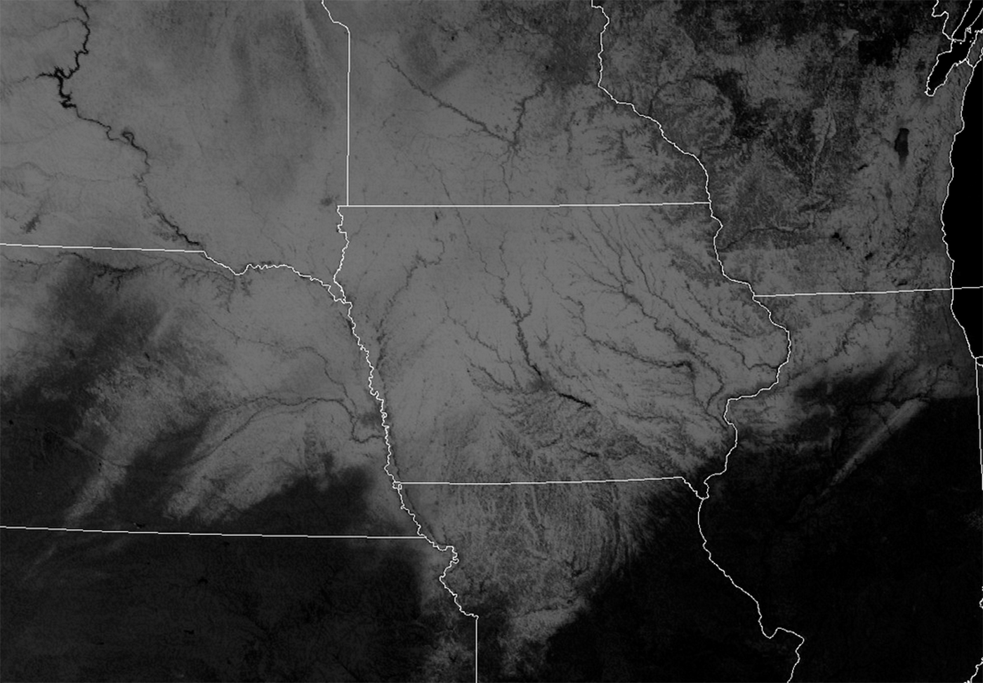
Check out this Saturday afternoon satellite view! The white would be snow and ice covered areas. For you geography majors 🙂 can you name all those rivers! Click image for a much larger view.
Forecast discussion…
Calm weather will continue into Monday. Chilly weather. A reinforcing shot of cold air will arrive on Sunday night into Tuesday. I can’t rule out a flurry on Sunday night and Monday. Nothing of significance.
Here is the future-cast satellite view on Sunday night into Monday.
This first image is for Sunday evening. You can see white over our region. A low stratus deck is forecast to move from north to south into our region on Sunday afternoon into Monday morning.

Moving ahead to Monday morning at 9 am

Then by Monday afternoon the guidance indicates perhaps some clearing. We will see how it goes. Either way, chilly few days ahead of us. And, with some clouds, it will feel even chillier.

Moving ahead to the middle and end of next week:
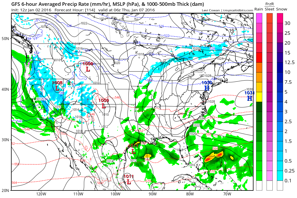
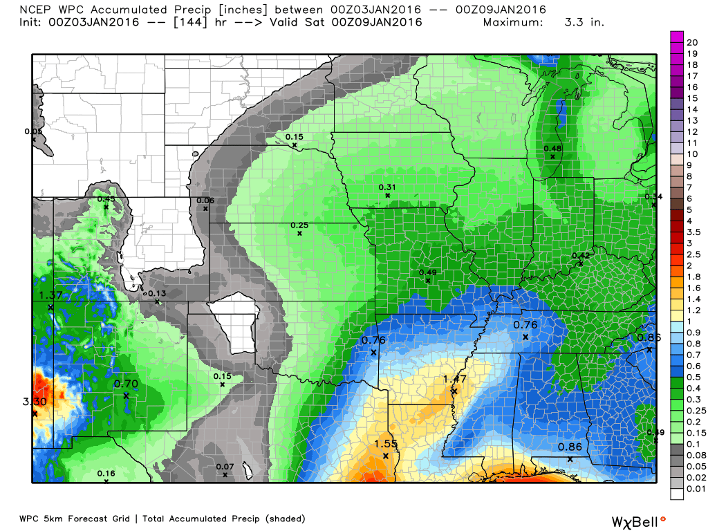
I am watching a possible precipitation maker for Wednesday into Friday.
Let’s get a glimpse of that on the GFS model guidance. This seems about right based on ensembles. Precipitation may move in as early as Wednesday night. I can not complaint rule out a few sleet pellets or brief period of freezing rain if the precipitation does move in before sunrise. However, at this time, it does not appear to be anything of significance. As always, this will need to be monitored. It only takes a little bit of freezing rain to cause some travel issues. Let’s keep an eye on it.
We would warm up enough on Thursday into Friday to change everything over to rain.
GFS maps
This first map is for Thursday morning around 1 am to 3 am. Some green over Missouri into western Tennessee. Again, let’s keep an eye on this. Temperatures could be near freezing.
I am fairly confident we will experience some precipitation with this event, but not confident on what time it arrives.
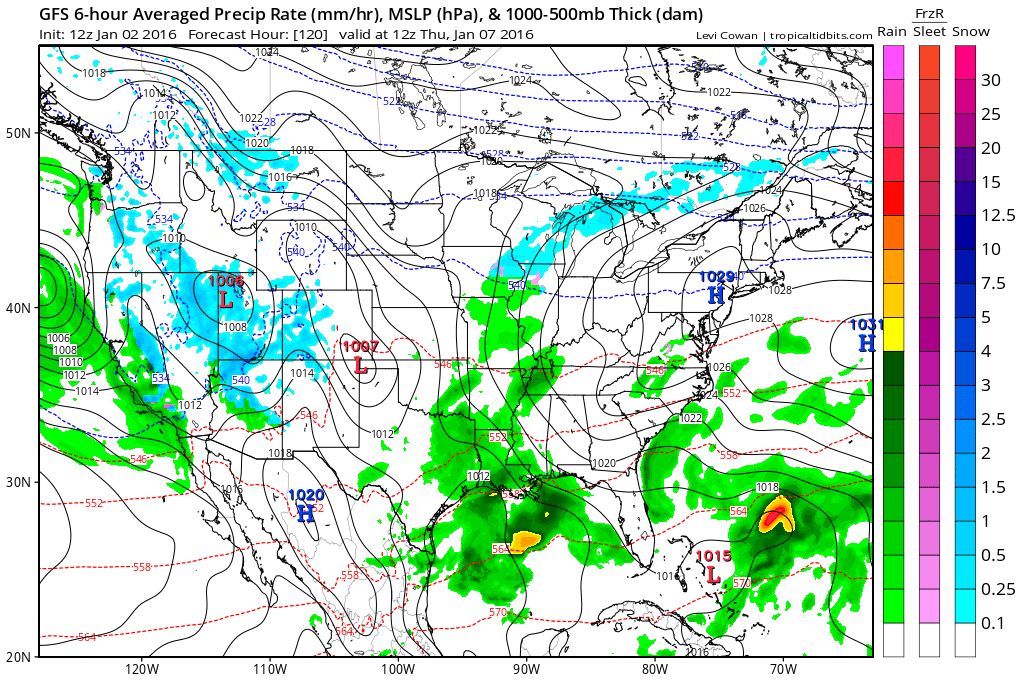
This next map is for 6 am on Thursday morning. This does not appear to be a big precipitation maker. But, some rain, none-the-less.
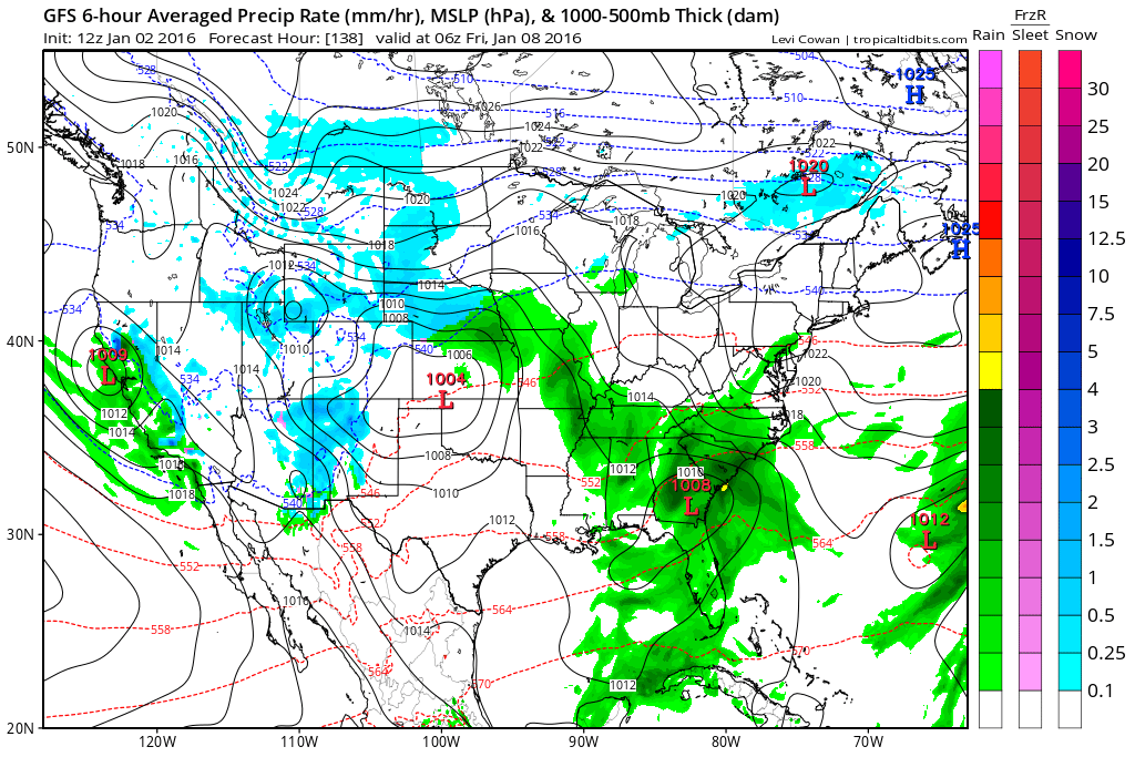
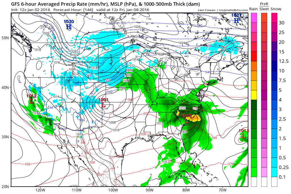
Moving ahead to Friday morning around 1 am to 3 am. You can see a 1004 millibar low over the Kansas and Oklahoma border. Rain in our region. Snow back into Nebraska.
Moving ahead to Friday morning at 6 am. Low over the Texas Panhandle. The GFS isn’t handling the placement of the low very well. Or the intensity. This will need to be monitored.
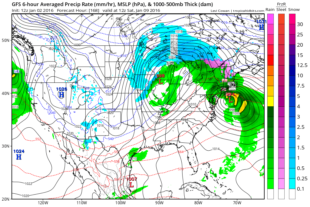
Finally, moving ahead to Saturday morning at 6 am. The system has rapidly moved into northern Illinois. GFS indicates the surface low at 998 mb. Rain should come to an end as the low departs.
In the long range, there continues to be indications of a wintry pattern for the second and third week of January. Of course this is in the long range and confidence is never very high once you get past day five through seven. Let’s keep an eye on it. It does appear that we may have a setup where quite a bit of cold could push southward into our region. And, perhaps some precipitation, as well.
Let’s monitor January 12th-20th for some snow or wintry precipitation.
Looking at CIPS analogs. This is basically a model that bases its forecast by comparing what is happening now to what has happened in the past (during similar patterns).
Colder temperatures appear almost a certainty. This is centered around January 10th-15th. The blue indicates below normal temperatures.

But, the real question will be snow. Can we bring a precipitation maker into the region. If so, snow would be a good bet. But, confidence is low, at this point. Just something to watch. I know you snow lovers are growing anxious for a few flakes.
I do believe winter weather is showing up in the charts. And, perhaps it is going to last for awhile. I was thinking the shift would start in the middle of January. I have been saying winter would show up in February and March of this year. But, perhaps signals are saying I will end up being off a couple of weeks. Let’s keep watching the charts and see how everything unfolds.
And, finally 🙂
It’s that time of the year again! Starting to hear people tell me their weather channel app (or other sources) are telling them to expect 2″ of snow on day thirteen. I remind everyone that we can barely forecast snowfall totals one or two days in advance, let alone day TEN!
Here is a great chart that I found online.
On the left you see the big number 28. That is 28″ of snow. See the bottom numbers? Those are the number of days out from the actual event. Then as you move right the day of the event grows closer and closer. Until you are at day zero. The models showed 28″ of snow on day ten. By the time the storm arrived it ended up producing 9″ of snow. Models are horrible beyond a certain point (sometimes they are horrible a day or two before an event). Just remember this when your weather channel app tells you to expect 2″ of snow ten days out.


Here are the current river stage forecasts. You can click your state and then the dot for your location. It will bring up the full forecast and hydrograph.
Click Here For River Stage Forecasts…
Here are some current forecast hydrographs. These will be updated each day with new information.


Smithland Lock and Dam

Paducah, Kentucky Forecast Stage

Cairo, Illinois

Cape Girardeau, Missouri
Clickable map


Here are the current river stage forecasts. You can click your state and then the dot for your location. It will bring up the full forecast and hydrograph.
Click Here For River Stage Forecasts…

No snow anticipated.

Sunday – No snow or ice anticipated.
Monday – No snow or ice anticipated.
Tuesday – No snow or ice anticipated.
Wednesday – No snow or ice anticipated.
Wednesday night – Monitor updates.
Thursday – Monitor updates.

No major changes in this update.

River flooding continues to be the main concern. A flash flood watch has been issued for Jackson, Union, and Alexander Counties in southern Illinois. Levee’s may be topped or may fail. Listen to local officials as they coordinate evacuations.
Monitor the latest crest forecast numbers.
Avoid flooded roadways.

Monitor river stages.
Avoid flooded roadways.

No wild card in the forecast through 48 hours. Calm weather into Monday.

How much precipitation should we expect over the next few days?
No rain in the short term forecast (or snow)
Watching Thursday and Friday for some rain chances.

Can we expect severe thunderstorms over the next 24 to 48 hours? Remember that a severe thunderstorm is defined as a thunderstorm that produces 58 mph winds or higher, quarter size hail or larger, and/or a tornado.
The thunderstorm threat level will be a ZERO for the next seven day.
.
No risk of severe weather through next Thursday.

We have regional radars and local city radars – if a radar does not seem to be updating then try another one. Occasional browsers need their cache cleared. You may also try restarting your browser. That usually fixes the problem. Occasionally we do have a radar go down. That is why I have duplicates. Thus, if one fails then try another one.
If you have any problems then please send me an email beaudodson@usawx.com
WEATHER RADAR PAGE – Click here —
We also have a new national interactive radar – you can view that radar by clicking here.
Local interactive city radars include St Louis, Mt Vernon, Evansville, Poplar Bluff, Cape Girardeau, Marion, Paducah, Hopkinsville, Memphis, Nashville, Dyersburg, and all of eastern Kentucky – these are interactive radars. Local city radars – click here
NOTE: Occasionally you will see ground clutter on the radar (these are false echoes). Normally they show up close to the radar sites – including Paducah.


Here is the official 6-10 day and 8-14 day temperature and precipitation outlook. Check the date stamp at the top of each image (so you understand the time frame).
The forecast maps below are issued by the Weather Prediction Center (NOAA).


The latest 8-14 day temperature and precipitation outlook. Note the dates are at the top of the image. These maps DO NOT tell you how high or low temperatures or precipitation will be. They simply give you the probability as to whether temperatures or precipitation will be above or below normal.


Here are the current river stage forecasts. You can click your state and then the dot for your location. It will bring up the full forecast and hydrograph.
Click Here For River Stage Forecasts…

Who do you trust for your weather information and who holds them accountable?
I have studied weather in our region since the late 1970’s. I have 37 years of experience in observing our regions weather patterns. My degree is in Broadcast Meteorology from Mississippi State University and an Associate of Science (AS). I am currently working on my Bachelor’s Degree in Geoscience.
My resume includes:
Member of the American Meteorological Society.
NOAA Weather-Ready Nation Ambassador.
Meteorologist for McCracken County Emergency Management. I served from 2005 through 2015.
I own and operate the Southern Illinois Weather Observatory.
Recipient of the Mark Trail Award, WPSD Six Who Make A Difference Award, Kentucky Colonel, and the Caesar J. Fiamma” Award from the American Red Cross.
In 2009 I was presented with the Kentucky Office of Highway Safety Award.
Recognized by the Kentucky House of Representatives for my service to the State of Kentucky leading up to several winter storms and severe weather outbreaks.
I am also President of the Shadow Angel Foundation which serves portions of western Kentucky and southern Illinois.
There is a lot of noise on the internet. A lot of weather maps are posted without explanation. Over time you should learn who to trust for your weather information.
My forecast philosophy is simple and straight forward.
- Communicate in simple terms
- To be as accurate as possible within a reasonable time frame before an event
- Interact with you on Twitter, Facebook, and the blog
- Minimize the “hype” that you might see on television or through other weather sources
- Push you towards utilizing wall-to-wall LOCAL TV coverage during severe weather events
I am a recipient of the Mark Trail Award, WPSD Six Who Make A Difference Award, Kentucky Colonel, and the Caesar J. Fiamma” Award from the American Red Cross. In 2009 I was presented with the Kentucky Office of Highway Safety Award. I was recognized by the Kentucky House of Representatives for my service to the State of Kentucky leading up to several winter storms and severe weather outbreaks.
If you click on the image below you can read the Kentucky House of Representatives Resolution.

Many of my graphics are from www.weatherbell.com – a great resource for weather data, model data, and more


You can sign up for my AWARE email by clicking here I typically send out AWARE emails before severe weather, winter storms, or other active weather situations. I do not email watches or warnings. The emails are a basic “heads up” concerning incoming weather conditions.