
.
January 22, 2018
Monday Forecast Details
From 11 AM onward
Forecast: Breezy and mild. A 30% of additional showers and thunderstorms. A mix of sun and clouds. Clearing from west to east.
Temperatures: MO ~ 58 to 63 and temps may fall late in the day IL ~ 58 to 62 during the morning and then falling late in the day KY ~ 60 to 65
What is the chance of precipitation? MO ~ 30% IL ~ 30% KY ~ 30% TN ~ 30%
Coverage of precipitation: Isolated during the afternoon.
Wind chill values: N/A
Accumulating snow or ice: No
Winds: South and southwest at 15 to 35 mph with higher gusts likely.
What impacts are anticipated from the weather? Wet roadways. Lightning possible. Strong winds.
My confidence in the forecast verifying: High
Is severe weather expected? Small chance of high winds with any storms that form.
The NWS defines severe weather as 58 mph wind or great, 1″ hail or larger, and/or tornadoes
Should I cancel my outdoor plans? No, but check radars
.
Monday Night Forecast Details:
Forecast: Becoming cloudy. Windy. Colder. Patchy light rain or snow flurries possible overnight. No accumulation.
Temperatures: MO ~ 32 to 36 IL ~ 30 to 35 KY ~ 33 to 36
What is the chance of precipitation? MO ~ 20% IL ~ 20% KY ~ 20% TN ~ 20%
Coverage of precipitation: None to isolated
Wind chill values: 20 to 30
Accumulating snow or ice: No
Winds: West and southwest at 15 to 25 mph and gusty
What impacts are anticipated from the weather? Wet roads.
My confidence in the forecast verifying: High
Is severe weather expected? No
The NWS defines severe weather as 58 mph wind or great, 1″ hail or larger, and/or tornadoes
Should I cancel my outdoor plans: No, but check radars.
.
January 23, 2018
Tuesday Forecast Details
Forecast: A mix of sun and clouds. Cooler. A slight chance of a snow flurry or sprinkle.
Temperatures: MO ~ 38 to 44 IL ~ 38 to 44 KY ~ 40 to 45
What is the chance of precipitation? MO ~ 10% IL ~ 10% KY ~ 10% TN ~ 10%
Coverage of precipitation: Most likely none
Wind chill values: 28 to 38
Accumulating snow or ice: No
Winds: West wind 7 to 14 mph with gusts to 16 mph
What impacts are anticipated from the weather? None
My confidence in the forecast verifying: High
Is severe weather expected? No
The NWS defines severe weather as 58 mph wind or great, 1″ hail or larger, and/or tornadoes
Should I cancel my outdoor plans? No
.
Tuesday Night Forecast Details:
Forecast: A few evening clouds, otherwise becoming mostly clear. Colder.
Temperatures: MO ~ 25 to 30 IL ~ 25 to 30 KY ~ 25 to 30
What is the chance of precipitation? MO ~ 0% IL ~ 0% KY ~ 0% TN ~ 0%
Coverage of precipitation: Most likely none
Wind chill values: 20 to 30
Accumulating snow or ice: No
Winds: West at 7 to 14 mph
What impacts are anticipated from the weather? None
My confidence in the forecast verifying: High
Is severe weather expected? No
The NWS defines severe weather as 58 mph wind or great, 1″ hail or larger, and/or tornadoes
Should I cancel my outdoor plans: No
.
January 24, 2018
Wednesday Forecast Details
Forecast: Mostly sunny
Temperatures: MO ~ 45 to 50 IL ~ 45 to 50 KY ~ 45 to 50
What is the chance of precipitation? MO ~ 0% IL ~ 0% KY ~ 0% TN ~ 0%
Coverage of precipitation: None
Wind chill values: N/A
Accumulating snow or ice: N0
Winds: West winds at 5 to 10 mph
What impacts are anticipated from the weather? None
My confidence in the forecast verifying: High
Is severe weather expected? No
The NWS defines severe weather as 58 mph wind or great, 1″ hail or larger, and/or tornadoes
Should I cancel my outdoor plans? No
.
Wednesday Night Forecast Details:
Forecast: Mostly clear.
Temperatures: MO ~ 25 to 30 IL ~ 25 to 30 KY ~ 25 to 30
What is the chance of precipitation? MO ~ 0% IL ~ 0% KY ~ 0% TN ~ 0%
Coverage of precipitation: None
Wind chill values: N/A
Accumulating snow or ice: No
Winds: South and southwest winds at 5 to 10 mph
What impacts are anticipated from the weather? None
My confidence in the forecast verifying: High
Is severe weather expected? No
The NWS defines severe weather as 58 mph wind or great, 1″ hail or larger, and/or tornadoes
Should I cancel my outdoor plans: No
.
January 25, 2018
Thursday Forecast Details
Forecast: Mostly sunny.
Temperatures: MO ~ 50 to 55 IL ~ 50 to 55 KY ~ 50 to 55
What is the chance of precipitation? MO ~ 0% IL ~ 0% KY ~ 0% TN ~ 0%
Coverage of precipitation: None
Wind chill values: N/A
Accumulating snow or ice: No
Winds: South and southwest at 7 to 14 mph
What impacts are anticipated from the weather? None
My confidence in the forecast verifying: High
Is severe weather expected? No
The NWS defines severe weather as 58 mph wind or great, 1″ hail or larger, and/or tornadoes
Should I cancel my outdoor plans? No
.
Thursday Night Forecast Details:
Forecast: Clear.
Temperatures: MO ~ 34 to 38 IL ~ 34 to 38 KY ~ 34 to 38
What is the chance of precipitation? MO ~ 0% IL ~ 0% KY ~ 0% TN ~ 0%
Coverage of precipitation: None
Wind chill values: N/A
Accumulating snow or ice: No
Winds: Southwest and west at 6 to 12 mph
What impacts are anticipated from the weather? None
My confidence in the forecast verifying: High
Is severe weather expected? No
The NWS defines severe weather as 58 mph wind or great, 1″ hail or larger, and/or tornadoes
Should I cancel my outdoor plans: No
.
January 26, 2018
Friday Forecast Details
Forecast: Partly to mostly sunny. Increasing clouds late in the day. Mild.
Temperatures: MO ~ 54 to 56 IL ~ 54 to 56 KY ~ 54 to 56
What is the chance of precipitation? MO ~ 10% IL ~ 10% KY ~ 10% TN ~ 10%
Coverage of precipitation: None
Wind chill values: N/A
Accumulating snow or ice: No
Winds: South and southwest at 7 to 14 mph
What impacts are anticipated from the weather? None
My confidence in the forecast verifying: Medium
Is severe weather expected? No
The NWS defines severe weather as 58 mph wind or great, 1″ hail or larger, and/or tornadoes
Should I cancel my outdoor plans? No
.
Friday Night Forecast Details:
Forecast: Cloudy. Showers possible.
Temperatures: MO ~ 44 to 48 IL ~ 44 to 48 KY ~ 44 to 48
What is the chance of precipitation? MO ~ 40% IL ~ 40% KY ~ 40% TN ~ 40%
Coverage of precipitation: Scattered
Wind chill values: N/A
Accumulating snow or ice: No
Winds: Southwest at 6 to 12 mph
What impacts are anticipated from the weather? Wet roadways
My confidence in the forecast verifying: Medium
Is severe weather expected? No
The NWS defines severe weather as 58 mph wind or great, 1″ hail or larger, and/or tornadoes
Should I cancel my outdoor plans: Monitor updates
.
January 27, 2018
Saturday Forecast Details
Forecast: Mostly cloudy. Showers possible.
Temperatures: MO ~ 52 to 56 IL ~ 52 to 56 KY ~ 52 to 56
What is the chance of precipitation? MO ~ 40% IL ~ 40% KY ~ 40% TN ~ 40%
Coverage of precipitation: Scattered
Wind chill values: N/A
Accumulating snow or ice: No
Winds: South and southwest at 7 to 14 mph
What impacts are anticipated from the weather? Wet roadways.
My confidence in the forecast verifying: Medium
Is severe weather expected? No
The NWS defines severe weather as 58 mph wind or great, 1″ hail or larger, and/or tornadoes
Should I cancel my outdoor plans? Monitor updates
.
Saturday Night Forecast Details:
Forecast: Partly to mostly cloudy.
Temperatures: MO ~ 30 to 35 IL ~ 30 to 35 KY ~ 30 to 35
What is the chance of precipitation? MO ~ 40% IL ~ 40% KY ~ 40% TN ~ 40%
Coverage of precipitation: Scattered
Wind chill values: N/A
Accumulating snow or ice: No
Winds: West at 6 to 12 mph
What impacts are anticipated from the weather? Wet roadways
My confidence in the forecast verifying: Medium
Is severe weather expected? No
The NWS defines severe weather as 58 mph wind or great, 1″ hail or larger, and/or tornadoes
Should I cancel my outdoor plans: Monitor updates
.
January 28, 2018
Sunday Forecast Details
Forecast: Mostly sunny. Cooler.
Temperatures: MO ~ 40 to 45 IL ~ 40 to 45 KY ~ 40 to 45
What is the chance of precipitation? MO ~ 0% IL ~ 0% KY ~ 0% TN ~ 0%
Coverage of precipitation: None
Wind chill values: N/A
Accumulating snow or ice: No
Winds: West at 5 to 10 mph
What impacts are anticipated from the weather? None
My confidence in the forecast verifying: Medium
Is severe weather expected? No
The NWS defines severe weather as 58 mph wind or great, 1″ hail or larger, and/or tornadoes
Should I cancel my outdoor plans? No
.
Sunday Night Forecast Details:
Forecast: Mostly clear and chilly.
Temperatures: MO ~ 30 to 35 IL ~ 30 to 35 KY ~ 30 to 35
What is the chance of precipitation? MO ~ 0% IL ~ 0% KY ~ 0% TN ~ 0%
Coverage of precipitation: None
Wind chill values: N/A
Accumulating snow or ice: No
Winds: West at 5 to 10 mph
What impacts are anticipated from the weather? None
My confidence in the forecast verifying: Medium
Is severe weather expected? No
The NWS defines severe weather as 58 mph wind or great, 1″ hail or larger, and/or tornadoes
Should I cancel my outdoor plans: No
.

.
Tonight through Saturday: Snow is not anticipated. A small chance of a flurry tonight. Nothing to worry about.
.

.
The National Weather Service definition of a severe thunderstorm is one that produces quarter size hail or larger, 58 mph winds or greater, and/or a tornado.
Monday night through Friday: Severe weather is not anticipated. Small chance of lightning Friday night and Saturday. Low confidence.
.

.
Interactive Weather Radar Page. Choose the city nearest your location: Click this link.
Short term outlook:
The good news is that I am not anticipating widespread bitterly cold air this week. Finally, a break in the pattern. This break may last into at least a portion of next week.
Tonight into Tuesday
Some clouds tonight. Gusty winds. An isolated light shower or flurry possible.
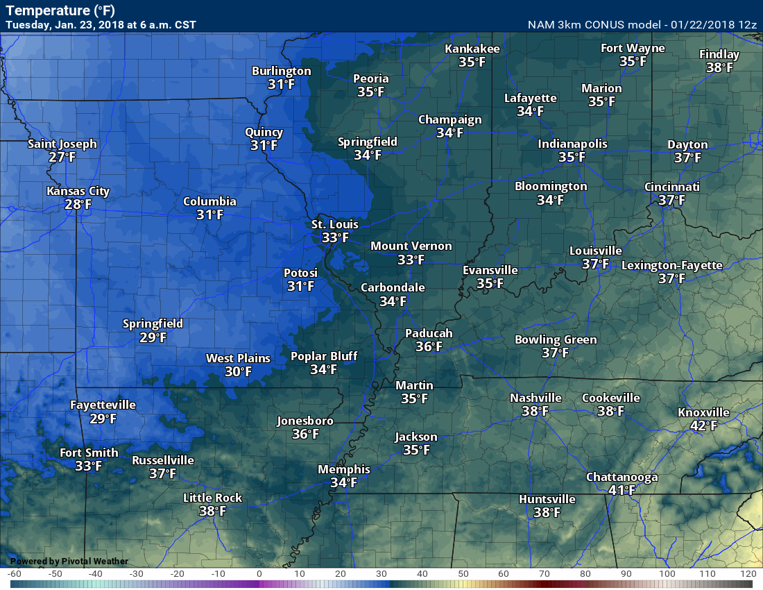
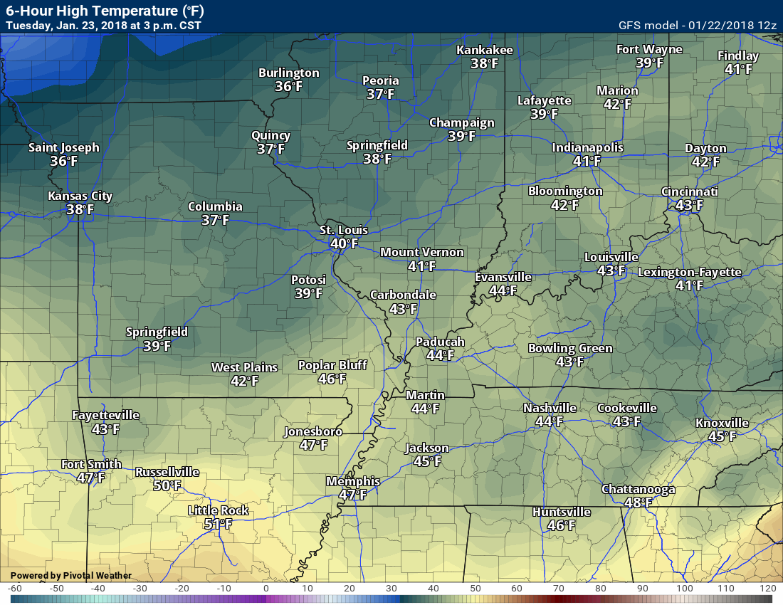
It will be cooler on Tuesday morning. Lows should dip into the 30’s. Highs on Tuesday may remain in the 40’s.
6 AM Tuesday temperatures.
.
.
3 PM Tuesday temperatures
.
Wednesday through Friday
Calm weather. A mix of sun and clouds. Highs mostly in the upper 40’s to middle 50’s and lows mostly in the middle 30’s to lower 40’s. Not too bad considering it is January. I am sure most of you will welcome a break from the extreme cold.
.
Beau’s Winter Weather Outlook
.

.
I am not tracking any snow or ice event. Keep checking back. The cold pattern may return as we move into next week and the following.


We offer regional radars and local city radars – if a radar does not update then try another one. Occasional browsers need their cache cleared. You may also try restarting your browser. This will usually fix any problems.
During the winter you can track snow and ice by clicking the winterize button on the local city view interactive radars.
You may email me at beaudodson@usawx.com
Interactive Weather Radar Page. Choose the city nearest your location: Click this link
National interactive radar: Click this link.