
.
January 17, 2018
Cold wind chills tonight.
Wednesday Night Forecast Details:
Forecast: Mostly clear. Bitterly cold. Low wind chills.
Temperatures: MO ~ 6 to 12 IL ~ 6 to 12 KY ~ 5 to 12
What is the chance of precipitation? MO ~ 0% IL ~ 0% KY ~ 0% TN ~ 0%
Coverage of precipitation: None
Wind chill values: -8 to 8
Accumulating snow or ice: No
Winds: South and southwest at 5 to 10 mph with gusts to 12
What impacts are anticipated from the weather? Low wind chill values. Icy roads from recent snow.
My confidence in the forecast verifying: High
Is severe weather expected? No
The NWS defines severe weather as 58 mph wind or great, 1″ hail or larger, and/or tornadoes
Should I cancel my outdoor plans: No
.
January 18, 2018
Thursday Forecast Details
Forecast: Mostly sunny. A little milder (still below normal and still cold)
Temperatures: MO ~ 32 to 36 IL ~ 32 to 36 KY ~ 32 to 36
What is the chance of precipitation? MO ~ 0% IL ~ 0% KY ~ 0% TN ~ 0%
Coverage of precipitation: None
Wind chill values: 15 to 25
Accumulating snow or ice: No
Winds: South and southwest at 5 to 10 mph with gusts to 16 mph
What impacts are anticipated from the weather? None
My confidence in the forecast verifying: High
Is severe weather expected? No
The NWS defines severe weather as 58 mph wind or great, 1″ hail or larger, and/or tornadoes
Should I cancel my outdoor plans? No
.
Thursday Night Forecast Details:
Forecast: Mostly clear. Cold.
Temperatures: MO ~ 18 to 24 IL ~ 18 to 24 KY ~ 18 to 24
What is the chance of precipitation? MO ~ 0% IL ~ 0% KY ~ 0% TN ~ 0%
Coverage of precipitation: None
Wind chill values: 15 to 20
Accumulating snow or ice: No
Winds: South and southwest at 5 to 10 mph with gusts to 20 mph
What impacts are anticipated from the weather? None
My confidence in the forecast verifying: High
Is severe weather expected? No
The NWS defines severe weather as 58 mph wind or great, 1″ hail or larger, and/or tornadoes
Should I cancel my outdoor plans: No
.
January 19, 2018
Friday Forecast Details
Forecast: Mostly sunny. Patchy fog possible. Not as cold.
Temperatures: MO ~ 38 to 44 IL ~ 38 to 44 KY ~ 38 to 44
What is the chance of precipitation? MO ~ 0% IL ~ 0% KY ~ 0% TN ~ 0%
Coverage of precipitation: None.
Wind chill values: 35 to 40
Accumulating snow or ice: No
Winds: South and southwest at 7 to 14 mph with gusts to 25 mph
What impacts are anticipated from the weather? Patchy fog.
My confidence in the forecast verifying: High
Is severe weather expected? No
The NWS defines severe weather as 58 mph wind or great, 1″ hail or larger, and/or tornadoes
Should I cancel my outdoor plans? No
.
Friday Night Forecast Details:
Forecast: A few clouds. Patchy fog possible. Small chance of drizzle. I will monitor this part of the forecast.
Temperatures: MO ~ 30 to 35 IL ~ 30 to 35 KY ~ 30 to 35
What is the chance of precipitation? MO ~ 5% IL ~ 5% KY ~ 5% TN ~ 5%
Coverage of precipitation: Most likely none. I can’t completely rule out some drizzle. I will need to monitor temperatures.
Wind chill values: 30 to 35
Accumulating snow or ice: Unlikely
Winds: South and southwest at 8 to 16 mph
What impacts are anticipated from the weather? Perhaps fog with low visibility. Maybe wet roadways. I will need to monitor the drizzle portion of the forecast.
My confidence in the forecast verifying: Medium
Is severe weather expected? No
The NWS defines severe weather as 58 mph wind or great, 1″ hail or larger, and/or tornadoes
Should I cancel my outdoor plans: No
.
January 20, 2018
Saturday Forecast Details
Forecast: Some fog. Cloudy. Patchy drizzle possible. Warmer.
Temperatures: MO ~ 46 to 52 IL ~ 45 to 50 KY ~ 46 to 52
What is the chance of precipitation? MO ~ 20% IL ~ 20% KY ~ 20% TN ~ 20%
Coverage of precipitation: Isolated
Wind chill values: N/A
Accumulating snow or ice: No
Winds: South and southwest at 10 to 20 mph
What impacts are anticipated from the weather? Maybe wet roadways
My confidence in the forecast verifying: Medium
Is severe weather expected? No
The NWS defines severe weather as 58 mph wind or great, 1″ hail or larger, and/or tornadoes
Should I cancel my outdoor plans? Monitor
.
Saturday Night Forecast Details:
Forecast: Cloudy. Fog possible. Patchy drizzle.
Temperatures: MO ~ 42 to 46 IL ~ 44 to 48 KY ~ 44 to 48
What is the chance of precipitation? MO ~ 20% IL ~ 20% KY ~ 20% TN ~ 20%
Coverage of precipitation: Isolated or patchy
Wind chill values: 40 to 45
Accumulating snow or ice: No
Winds: South and southwest at 8 to 16 mph
What impacts are anticipated from the weather? Wet roadways. Patchy fog.
My confidence in the forecast verifying: Medium
Is severe weather expected? No
The NWS defines severe weather as 58 mph wind or great, 1″ hail or larger, and/or tornadoes
Should I cancel my outdoor plans: Have a plan B
.
January 21, 2018
Sunday Forecast Details
Forecast: Cloudy. Patchy fog. Breezy. A few spotty showers. Most of the day should be dry. Mild.
Temperatures: MO ~ 54 to 56 IL ~ 52 to 56 KY ~ 52 to 56
What is the chance of precipitation? MO ~ 30% IL ~ 30% KY ~ 30% TN ~ 30%
Coverage of precipitation: Isolated to scattered
Wind chill values: N/A
Accumulating snow or ice: No
Winds: South and southwest at 10 to 15 mph with gusts to 30 mph
What impacts are anticipated from the weather? Wet roadways. If fog develops, then lower visibility possible
My confidence in the forecast verifying: Medium
Is severe weather expected? No
The NWS defines severe weather as 58 mph wind or great, 1″ hail or larger, and/or tornadoes
Should I cancel my outdoor plans? No, but check radars.
.
Sunday Night Forecast Details:
Forecast: Cloudy. Rain likely. Thunderstorms possible. Locally heavy rain possible. Gusty winds.
Temperatures: MO ~ 38 to 44 IL ~ 38 to 44 KY ~ 38 to 44
What is the chance of precipitation? MO ~ 80% IL ~ 80% KY ~ 80% TN ~ 80%
Coverage of precipitation: Becoming widespread.
Wind chill values: 34 to 40
Accumulating snow or ice: No
Winds: South wind at 10 to 20 mph with gusts to 35 mph
What impacts are anticipated from the weather? Wet roadways. Lightning.
My confidence in the forecast verifying: Medium
Is severe weather expected? Monitor updates
The NWS defines severe weather as 58 mph wind or great, 1″ hail or larger, and/or tornadoes
Should I cancel my outdoor plans: Have a plan B
.
January 22, 2018
Monday Forecast Details
Forecast: Mostly cloudy. Breezy. Showers possible before 2 PM. Rain should be ending west to east. A few downpours possible.
Temperatures: MO ~ 44 to 48 IL ~ 44 to 48 KY ~ 44 to 48
What is the chance of precipitation? MO ~ 60% IL ~ 60% KY ~ 60% TN ~ 60%
Coverage of precipitation: Scattered to perhaps widespread early in the morning
Wind chill values: N/A
Accumulating snow or ice: No
Winds: Winds becoming west and southwest at 14 to 25 mph and gusty.
What impacts are anticipated from the weather? Perhaps wet roadways. Perhaps lightning early in the morning.
My confidence in the forecast verifying: Medium
Is severe weather expected? Unlikely
The NWS defines severe weather as 58 mph wind or great, 1″ hail or larger, and/or tornadoes
Should I cancel my outdoor plans? No
.
Monday Night Forecast Details:
Forecast: Clearing. An evening shower possible, but most of the rain should be over.
Temperatures: MO ~ 38 to 44 IL ~ 38 to 44 KY ~ 38 to 44
What is the chance of precipitation? MO ~ 0% IL ~ 0% KY ~ 0% TN ~ 0%
Coverage of precipitation: None
Wind chill values: 30 to 35
Accumulating snow or ice: No
Winds: North at 5 to 10 mph
What impacts are anticipated from the weather? None.
My confidence in the forecast verifying: Medium
Is severe weather expected? No
The NWS defines severe weather as 58 mph wind or great, 1″ hail or larger, and/or tornadoes
Should I cancel my outdoor plans: No
.

.
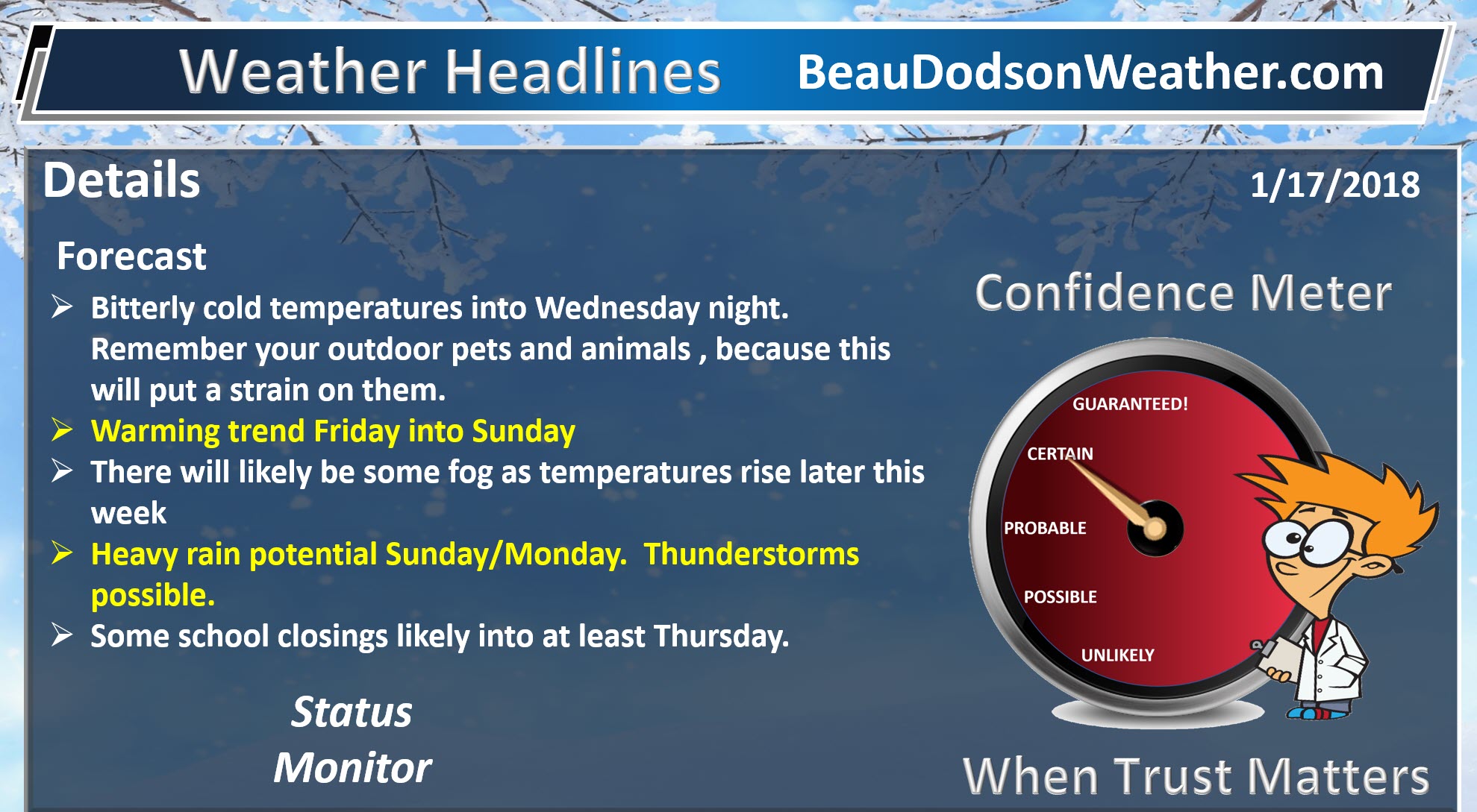
Tonight through next Tuesday: Bitterly cold air and low wind chill values tonight and early tomorrow morning. No snow or ice anticipated. Roads will remain icy.
.

.
The National Weather Service definition of a severe thunderstorm is one that produces quarter size hail or larger, 58 mph winds or greater, and/or a tornado.
Sunday and Sunday night: Thunderstorms will be possible. Lightning would be the main concern. Perhaps some gusty winds. Severe weather is not anticipated.
.

January 17, 2018
The daily outlook can be found at the bottom of this post.
Forecast
Interactive Weather Radar Page. Choose the city nearest your location: Click this link
Our active weather pattern is going to continue into the coming weeks.
First, we have to deal with the cold temperatures over the next 48 hours.
Highs today will range from 18 to 26 degrees. The colder air will be over the deeper snow pack.
Lows tonight will dip back down into the upper single digits to lower teens. Cold!
The good news is that a warming trend will begin on Thursday and Friday. This will lead to high temperatures in the 30’s on Thursday and perhaps the 40’s on Friday.
Even warmer air arrives on Saturday and Sunday ahead of our next weather maker.
Highs on Saturday will likely reach into the upper 40’s to lower 50’s. Lower to middle 50’s are possible on Sunday. Some of the guidance even indicates 60 degree temperatures.
We will likely have to deal with some dense fog from time to time. Especially over the snow pack area.
I will need to monitor the fog risk. Typically, as warmer air moves into our region over a snow pack, we have dense fog.
A few light showers or drizzle will be possible late Friday night into Saturday night. This will occur as low level moisture increases. Temperatures Friday night may dip below freezing. IF drizzle were to form, then we would need to watch the bridges and overpasses.
Active precipitation pattern
We have several storm systems to monitor over the next three weeks.
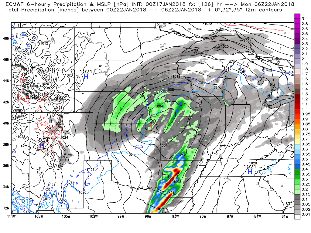
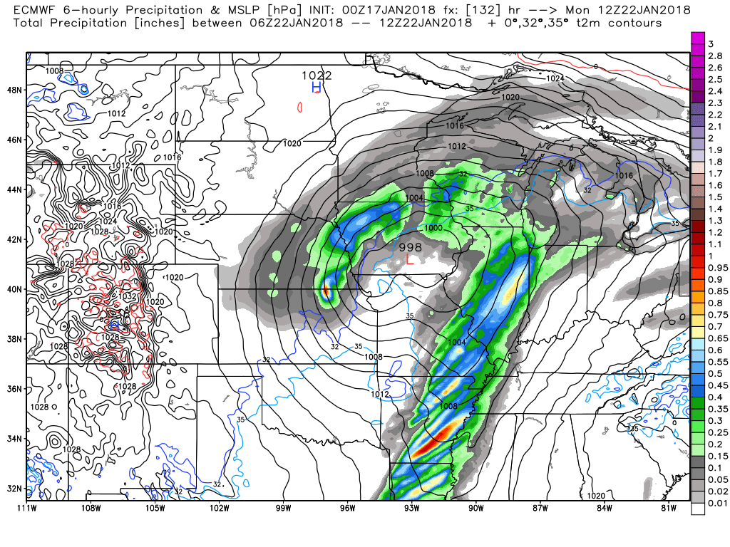
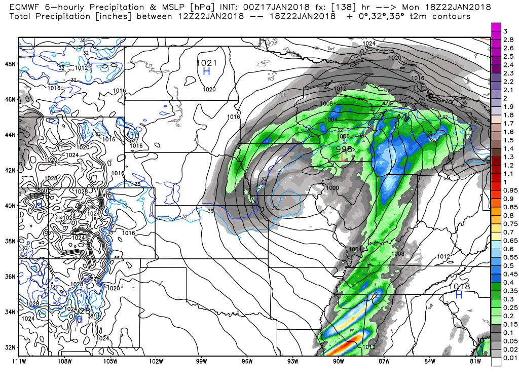
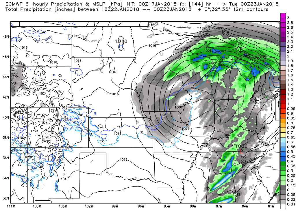
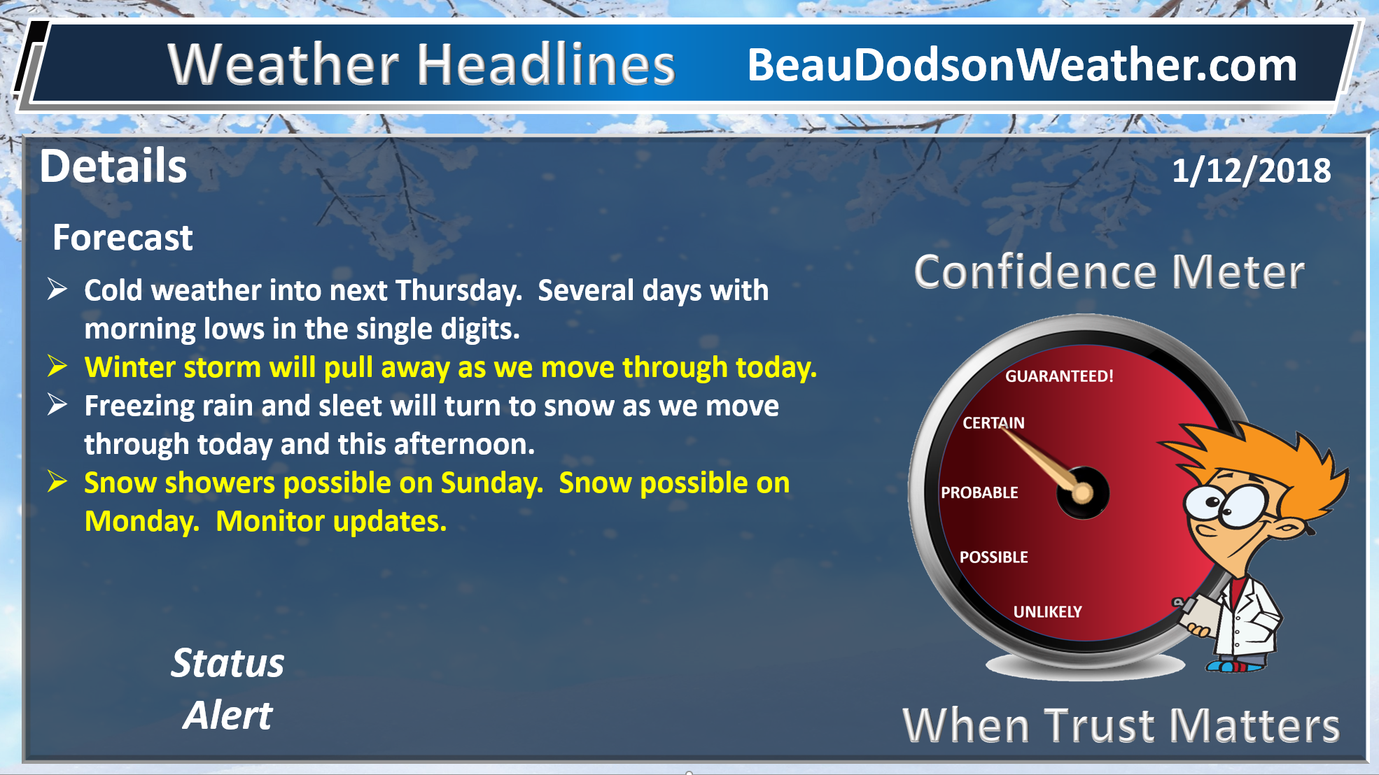
The first system will arrive on Sunday afternoon into Monday night. This system will be warm and will produce rain. I can’t rule out thunderstorms along the cold front.
The greatest rain chance will be Sunday night into early Monday morning.
Here is the EC six hour rain totals. You can see the movement of the system.
12 PM to 6 PM Sunday
The colors represent rain totals for the six hour period.
.

.
6 PM Sunday to 12 AM Monday
The colors represent rain totals for the six hour period.
.
.
12 AM to 6 AM Monday
The colors represent rain totals for the six hour period.
.
.
6 AM to 12 PM Monday
The colors represent rain totals for the six hour period.
.
.
12 PM to 6 PM Monday
The colors represent rain totals for the six hour period.
.
.
Wind fields aloft are strong. Strong and gusty winds are possible Sunday into Monday.
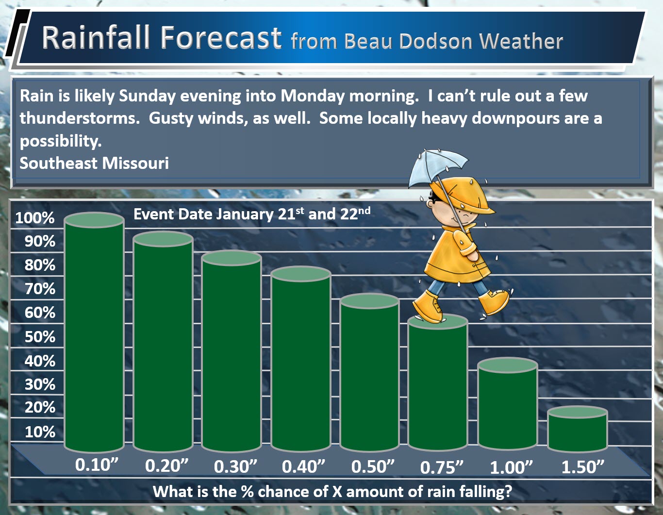
Rainfall totals of 0.30″ to 0.60″ are anticipated. Locally higher totals are likely. This is especially true if thunderstorms form.
Here are my rainfall probability numbers. What is the % chance of X amount of rain falling.
This graphic is for southeast Missouri
.
.
This graphic is for southern Illinois, western Kentucky, and northwest Tennessee
.

.
With the recent heavy snow pack we could have some water issues in a few locations. Let’s keep an eye on it. It does not appear to be a large flash flood event. Just some pockets of problems could occur.
The snow will likely have melted by the time the line of showers and thunderstorms arrive.
There is a small chance of flurries as the colder air moves in behind the cold front. At this time, accumulation appears unlikely. The most likely area for this to happen would be across northern parts of southeast Missouri and northern parts of southern Illinois.
Another system is possible towards the middle of next week and then another towards next weekend. It is still too early to know if these two events will be rain, snow, or both. Guidance is mixed on the topic. It is still too far out for any real confidence.
Of interest has been the potential of larger systems towards the end of next week. Somewhere between the 25th and 29th. Guidance has been hinting at this event for awhile. Perhaps a large precipitation maker. Again, too soon to know rain or snow or both. Monitor updates.
.
Beau’s Winter Weather Outlook
.
.


We offer regional radars and local city radars – if a radar does not update then try another one. Occasional browsers need their cache cleared. You may also try restarting your browser. This will usually fix any problems.
During the winter you can track snow and ice by clicking the winterize button on the local city view interactive radars.
You may email me at beaudodson@usawx.com
Interactive Weather Radar Page. Choose the city nearest your location: Click this link
National interactive radar: Click this link.