
.
Thank you for all the snow reports and photographs!
Short update tonight. It has been a LONG three days!
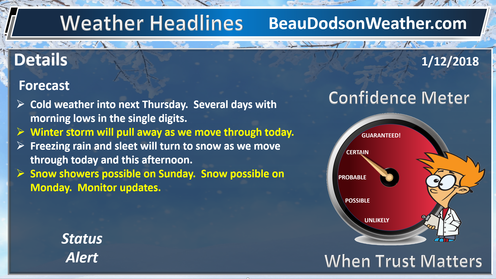
Bitterly cold air over the coming week. Snow likely Monday. Some accumulation possible.
Numerous nights with lows dipping into the single digits.
Don’t forget our outdoor friends. Furry friends also are cold in this weather.
.
January 12, 2018
Friday Night Forecast Details:
Winter Storm Alert
Blowing and drifting snow likely (in areas that have received snow)
Forecast: Cloudy. Cold. Windy. Low wind chill values of -5 to 10 above. Blowing and drifting snow (in areas that received the snow). Snow this evening over western Kentucky and portions of western Tennessee. Precipitation ending from west to east. Heavy snow possible over the Pennyrile area of western Kentucky before 8 PM. Heavy snow will be ending over the rest of western KY and western Tennessee. Banding could produce another 2 to 3″ of snow in some locations (mainly the Pennyrile area of western Kentucky).
Temperatures: MO ~ 14 to 18 IL ~ 12 to 16 KY ~ 10 to 15
What is the chance of precipitation? MO ~ 40% IL ~ 40% KY ~ 80% ending west to east TN ~ 60% ending west to east
Coverage of precipitation: Ending from west to east.
Wind chill values: -5 to 10 above
Accumulating snow or ice: Yes.
Winds: North at 10 to 15 mph with gusts to 35 mph
What impacts are anticipated from the weather? Icy roads and surfaces. Drifting snow. Blowing snow. Low wind chills.
My confidence in the forecast verifying: High
Is severe weather expected? No
The NWS defines severe weather as 58 mph wind or great, 1″ hail or larger, and/or tornadoes
Should I cancel my outdoor plans: Have a plan B
.
January 13, 2018
Saturday Forecast Details
Forecast: A mix of sun and clouds. Cold. Breezy during the morning.
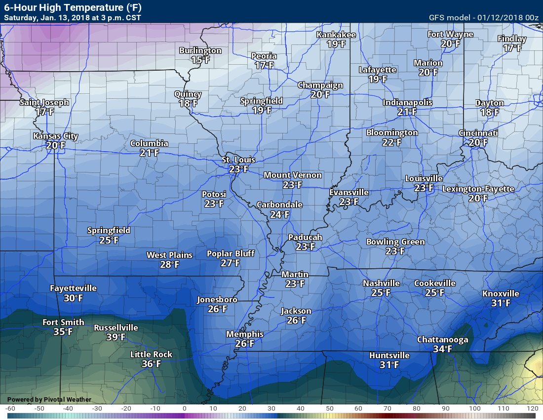
Temperatures: MO ~ 22 to 26 IL ~ 22 to 25 KY ~ 22 to 25
What is the chance of precipitation? MO ~ 10% IL ~ 10% KY ~ 10% TN ~ 10%
Coverage of precipitation: Most likely none.
Wind chill values: 5 to 15 degrees
Accumulating snow or ice: No
Winds: North at 10 to 15 mph with gusts before 12 pm in the 20 to 25 mph range.
What impacts are anticipated from the weather? Icy roads will remain. Low wind chill values.
My confidence in the forecast verifying: High
Is severe weather expected? No
The NWS defines severe weather as 58 mph wind or great, 1″ hail or larger, and/or tornadoes
Should I cancel my outdoor plans? Have a plan B
.
Saturday Night Forecast Details:
Forecast: Mostly clear. A few clouds. Bitterly cold. Temperatures will vary based on snow and ice cover.
Temperatures: MO ~ 5 to 10 IL ~ 4 below to 5 above KY ~ 5 below to 6 above
What is the chance of precipitation? MO ~ 0% IL ~ 0% KY ~ 0% TN ~ 0%
Coverage of precipitation: Most likely none. Small chance of flurries.
Wind chill values: -5 to 5
Accumulating snow or ice: No
Winds: North at 6 to 12 mph
What impacts are anticipated from the weather? Icy roads will remain. Low wind chill values.
My confidence in the forecast verifying: High
Is severe weather expected? No
The NWS defines severe weather as 58 mph wind or great, 1″ hail or larger, and/or tornadoes
Should I cancel my outdoor plans: Have a plan B
.
January 14, 2018
Sunday Forecast Details
Forecast: Partly to occasionally mostly cloudy. Cold. Snow flurries or snow showers possible. Little or no accumulation.
Temperatures: MO ~ 20 to 25 IL ~ 18 to 24 KY ~ 18 to 24
What is the chance of precipitation? MO ~ 20% IL ~ 20% KY ~ 20% TN ~ 20%
Coverage of precipitation: Spotty snow showers possible.
Wind chill values: -8 to 8 above during the morning. 8 to 16 during the afternoon.
Accumulating snow or ice: Most likely no
Winds: North at 10 to 15 mph
What impacts are anticipated from the weather? Icy roads will remain. Low wind chill values.n
My confidence in the forecast verifying: Medium
Is severe weather expected? No
The NWS defines severe weather as 58 mph wind or great, 1″ hail or larger, and/or tornadoes
Should I cancel my outdoor plans? Have a plan B
.
Sunday Night Forecast Details:
Forecast: Quite a few clouds. Snow flurries possible.
Temperatures: MO ~ 16 to 22 IL ~ 16 to 22 KY ~ 16 to 22
What is the chance of precipitation? MO ~ 20% IL ~ 20% KY ~ 20% TN ~ 20%
Coverage of precipitation: Scattered flurries or snow showers
Wind chill values: -5 to 10
Accumulating snow or ice: Monitor
Winds: Variable at 5 to 10 mph
What impacts are anticipated from the weather? Roads may still be icy
My confidence in the forecast verifying: Medium
Is severe weather expected? No
The NWS defines severe weather as 58 mph wind or great, 1″ hail or larger, and/or tornadoes
Should I cancel my outdoor plans: Have a plan B
.
.
January 15, 2018
Monday Forecast Details
Winter weather alert for late morning into the evening hours. Snow likely.
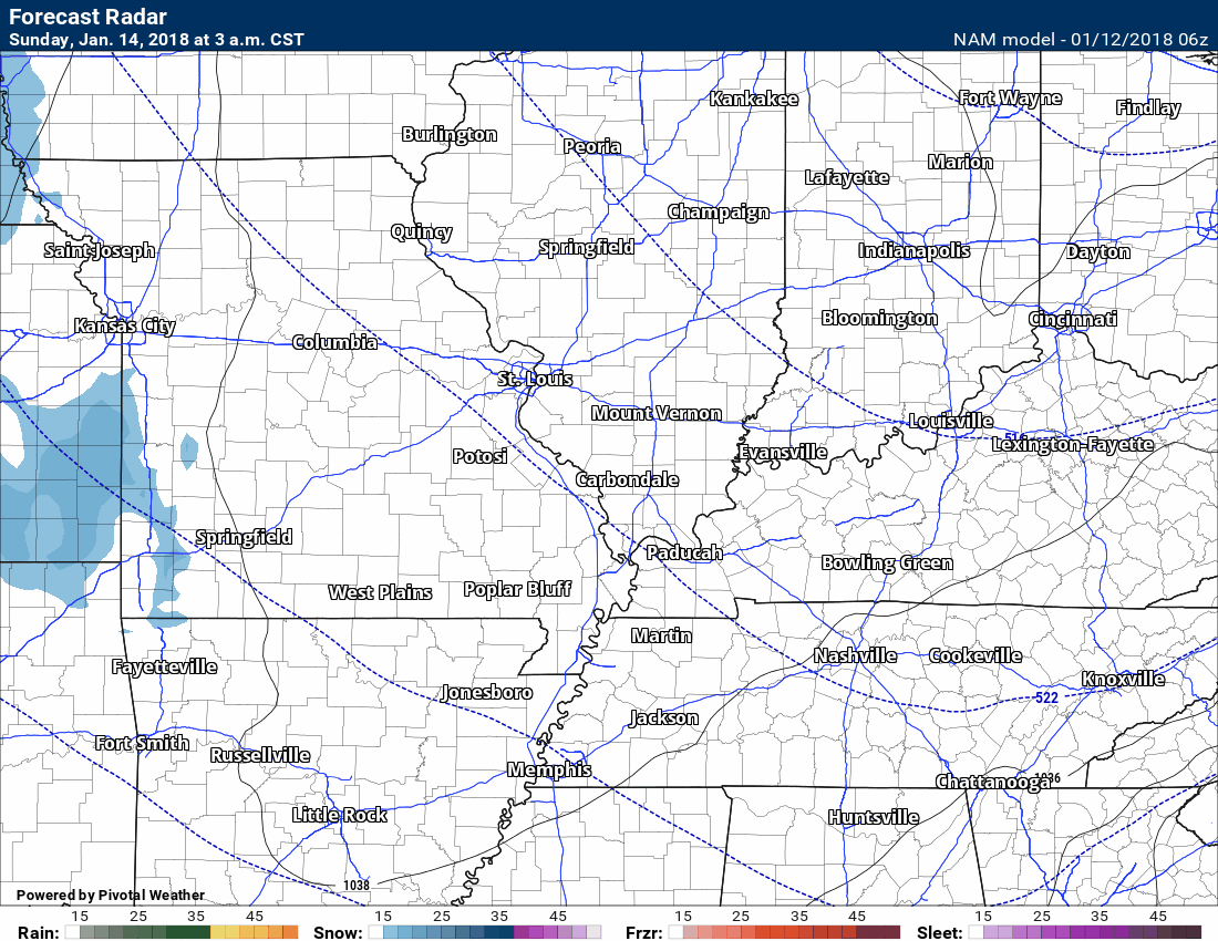
Forecast: Increasing clouds. Cold. A band of snow developing from the north. Snow may be mixed with sleet or rain near the KY/TN border and across the Missouri Bootheel. Most likely time period would be after 11 am. I will need to fine tune that part of the forecast. Some accumulation possible.
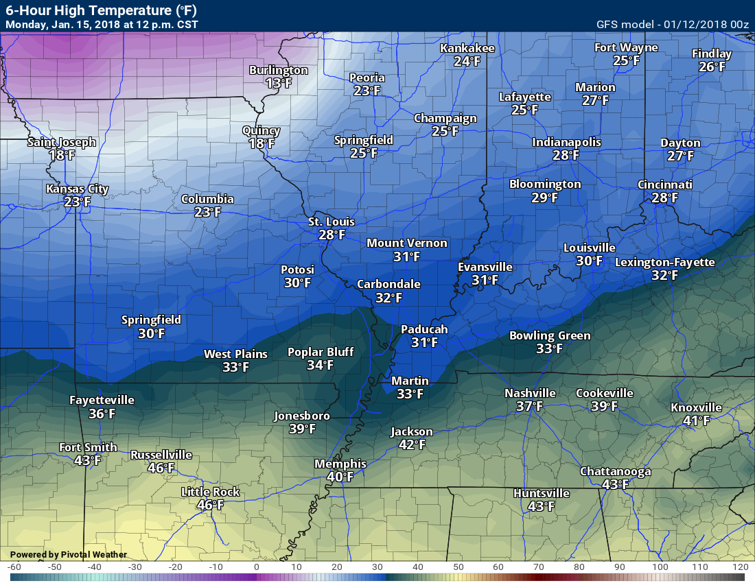
Temperatures: MO ~ 32 to 36 IL ~ 28 to 34 KY ~ 28 to 24
What is the chance of precipitation? MO ~ 40% IL ~ 70% KY ~ 60% TN ~ 50%
Coverage of precipitation: A band of precipitation possible moving north to south.
Wind chill values: 18 to 24
Accumulating snow or ice: Yes. One to three inches of snow will be possible.
Winds: Variable at 8 to 16 becoming north at 10 to 20 mph and gusty
What impacts are anticipated from the weather? Icy roads possible. Blowing snow possible late.
My confidence in the forecast verifying: Medium
Is severe weather expected? No
The NWS defines severe weather as 58 mph wind or great, 1″ hail or larger, and/or tornadoes
Should I cancel my outdoor plans? Have a plan B
.
Monday Night Forecast Details:
Winter weather alert for the evening hours
Wind chill alert for the overnight hours into Tuesday morning
Forecast: Cloudy with snow showers possible. Bitterly cold. Blowing snow possible.
Temperatures: MO ~ 3 to 8 IL ~ 2 below to 6 above KY ~ 2 below to 8 above
What is the chance of precipitation? MO ~ 30% IL ~ 40% KY ~ 50% early TN ~ 50% early
Coverage of precipitation: Scattered early
Wind chill values: -12 to 8 above
Accumulating snow or ice: Yes, but ending
Winds: North at 10 to 20 mph. Gusty winds.
What impacts are anticipated from the weather? Icy roads possible. Bitterly cold air. Low wind chill values. Blowing snow possible.
My confidence in the forecast verifying: Medium
Is severe weather expected? No
The NWS defines severe weather as 58 mph wind or great, 1″ hail or larger, and/or tornadoes
Should I cancel my outdoor plans: Have a plan B
.
January 16, 2018
Tuesday Forecast Details
Wind chill alert Tuesday morning
Forecast: Partly cloudy. Bitterly cold.
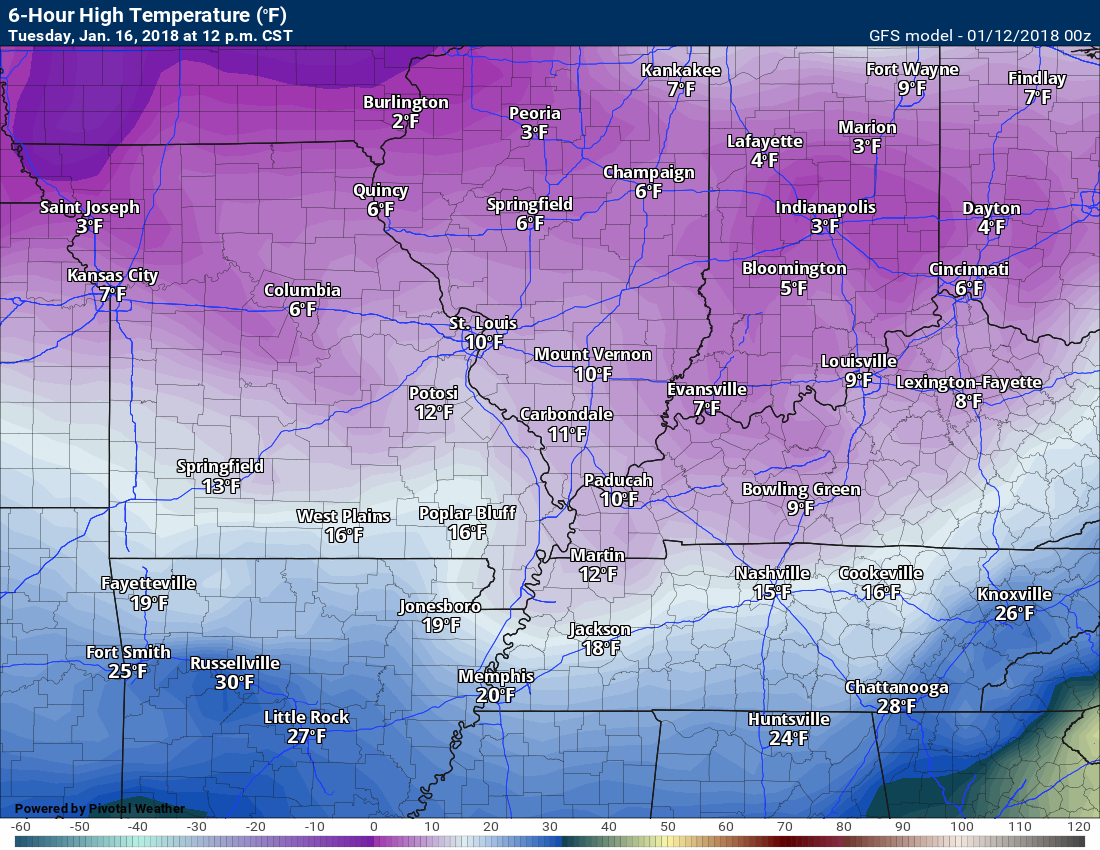
Temperatures: MO ~ 16 to 24 IL ~ 16 to 24 KY ~ 16 to 24
What is the chance of precipitation? MO ~ 10% IL ~ 10% KY ~ 10% TN ~ 10%
Coverage of precipitation: Most likely none
Wind chill values: -10 to 10
Accumulating snow or ice: No
Winds: North at 10 to 15 mph
What impacts are anticipated from the weather? Icy roads possible. Bitterly cold air. Low wind chill values.
My confidence in the forecast verifying: Medium
Is severe weather expected? No
The NWS defines severe weather as 58 mph wind or great, 1″ hail or larger, and/or tornadoes
Should I cancel my outdoor plans? Have a plan B
.
Tuesday Night Forecast Details:
Wind chill alert
Forecast: Mostly clear. Bitterly cold.
Temperatures: MO ~ 4 to 8 IL ~ 4 to 8 KY ~ 5 to 10
What is the chance of precipitation? MO ~ 0% IL ~ 0% KY ~ 0% TN ~ 0%
Coverage of precipitation: None
Wind chill values: -10 to 10
Accumulating snow or ice: No
Winds: North at 5 to 10 mph
What impacts are anticipated from the weather? Icy roads possible. Bitterly cold air. Low wind chill values.
My confidence in the forecast verifying: Medium
Is severe weather expected? No
The NWS defines severe weather as 58 mph wind or great, 1″ hail or larger, and/or tornadoes
Should I cancel my outdoor plans: Have a plan B
.
January 17, 2018
Wednesday Forecast Details
Wind chill alert Wednesday morning
Forecast: Partly cloudy. Bitterly cold.
Temperatures: MO ~ 16 to 24 IL ~ 16 to 24 KY ~ 16 to 24
What is the chance of precipitation? MO ~ 0% IL ~ 0% KY ~ 0% TN ~ 0%
Coverage of precipitation: Most likely none
Wind chill values: -5 to 12
Accumulating snow or ice: No
Winds: North at 10 to 15 mph
What impacts are anticipated from the weather? Low wind chill values.
My confidence in the forecast verifying: Medium
Is severe weather expected? No
The NWS defines severe weather as 58 mph wind or great, 1″ hail or larger, and/or tornadoes
Should I cancel my outdoor plans? Have a plan B
.
Wednesday Night Forecast Details:
Forecast: Mostly clear. Bitterly cold.
Temperatures: MO ~ 4 to 8 IL ~ 4 to 8 KY ~ 5 to 10
What is the chance of precipitation? MO ~ 0% IL ~ 0% KY ~ 0% TN ~ 0%
Coverage of precipitation: None
Wind chill values: -8 to 12
Accumulating snow or ice: No
Winds: North at 5 to 10 mph
What impacts are anticipated from the weather? Low wind chill values.
My confidence in the forecast verifying: Medium
Is severe weather expected? No
The NWS defines severe weather as 58 mph wind or great, 1″ hail or larger, and/or tornadoes
Should I cancel my outdoor plans: Have a plan B
.
Saturday 3 PM temperature map
.
.
Sunday 3 PM temperature map
.

.
Monday 3 PM temperature map
.
.
Tuesday 12 PM temperature map
.
.
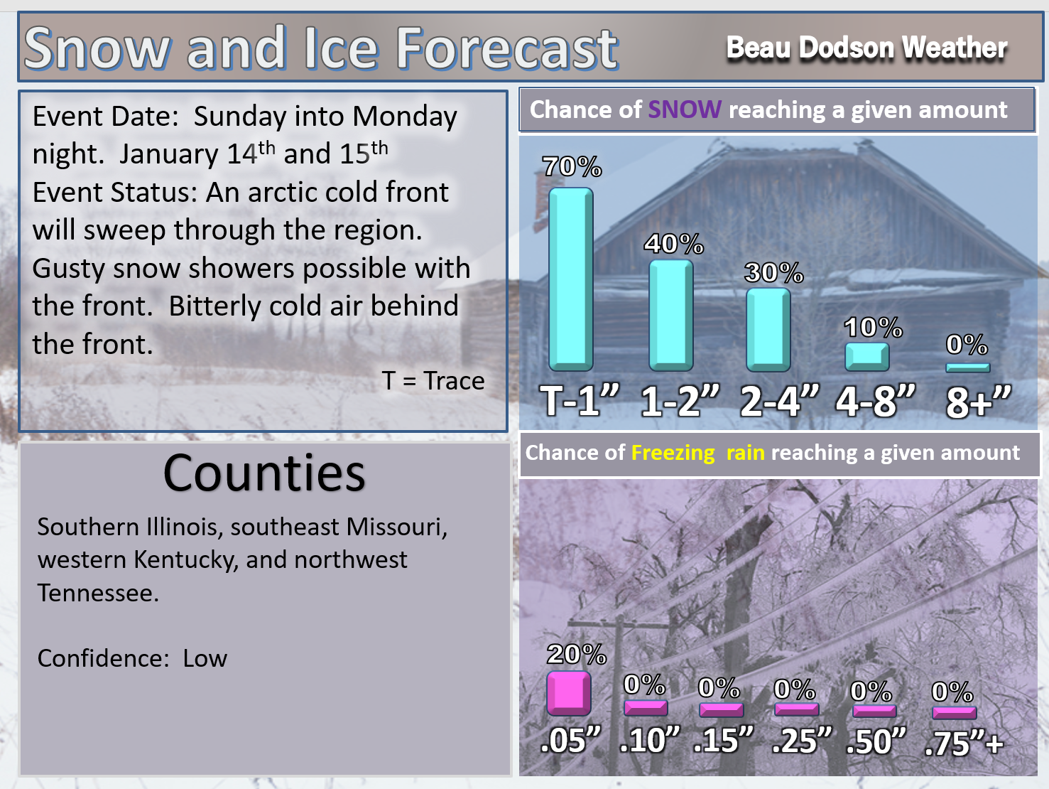
A few snow showers are possible on Sunday and Sunday night.
A strong arctic cold front will arrive on Monday and Tuesday. A band of gusty snow showers may accompany the front. There is the potential for accumulating snow, especially on Monday.
Winds of 30 to 40 mph will accompany the cold front and sharply colder air will follow.
You can expect widespread single digits on Tuesday and Wednesday morning. Winds chills below zero, as well.
Here is the future-cast radar for Sunday into Monday. You can see that band of precipitation along the front on Monday.
Time stamp upper left hand corner of the animation.
.
.
Beau’s Winter Weather Outlook
.
Sunday and Monday
Monday has the higher chance of producing accumulating snow.
.
.


We offer regional radars and local city radars – if a radar does not update then try another one. Occasional browsers need their cache cleared. You may also try restarting your browser. This will usually fix any problems.
During the winter you can track snow and ice by clicking the winterize button on the local city view interactive radars.
You may email me at beaudodson@usawx.com
Interactive Weather Radar Page. Choose the city nearest your location: Click this link
National interactive radar: Click this link.