8 AM Video update
Friday the 13th
![]() .
.

Are you in need of new eye glasses? New contacts? Perhaps you need an eye exam. Then be sure and visit the Eye Care Associates of western Kentucky (the Paducah location). For all of your families eye care needs.
Visit their web-site here. Or, you can also visit their Facebook page.

Best at Enabling Body Shop Profitability since 1996. Located In Paducah Kentucky and Evansville Indiana; serving all customers in between. They provide Customer Service, along with all the tools necessary for body shops to remain educated and competitive. Click the logo above for their main web-site.
You can find McClintock Preferred Finishes on Facebook, as well

Expressway Carwash and Express Lube are a locally owned and operated full-service Carwash and Lube established in 1987.
They have been proudly serving the community for 29 years now at their Park Avenue location and 20 years at their Southside location. They have been lucky enough to partner with Sidecar Deli in 2015, which allows them to provide their customers with not only quality service, but quality food as well.
If you haven’t already, be sure to make Expressway your one-stop shop, with their carwash, lube and deli. For hours of operation and pricing visit www.expresswashlube.com or Expressway Carwash on Facebook.
.
.
Looking for some tasty holiday treats? Fluff Cupcakes has what you and your family need. Located in Benton, Kentucky. They even deliver!

**** VALENTINE’S DAY SPECIAL **** $25 dollar special includes ~ 4 assorted Valentine fluff cupcakes in a fabulous box! 18″ Mylar Happy Valentine Day cupcake balloon tied to the box! Valentine’s Day enclosure card! Free delivery in Marshall County! Free delivery to businesses in Paducah, Murray, and Mayfield! Payment is required at time of order. To place an order you can message Tracy on the fluff cupcake page, email, text, or call. Tracy will invoice thru PayPal, & also accepts credit/debit cards, cash, and/or checks. 270-205-2552 tracyd@dcelectricinc.com
I have used Fluff Cupcakes, during Thanksgiving and Christmas, for the last couple of years. I can tell you that the cupcakes are delicious. Be sure and contact Tracy and place your order. Birthdays, holidays, or just because! Visit them on Facebook at this link – click here

Heath Health Foods is a locally owned and operated retail health and wellness store. Since opening in February 2006; the store has continued to grow as a ministry with an expanding inventory which also offers wellness appointments and services along with educational opportunities.
Visit their web-site here. And. visit Heath Health Foods on Facebook!
.
If you are on this site then it means you are a paying customer to Weather Talk. If you are not a customer (because someone sent you the password or link) and would like to become one then visit www.weathertalk.com
If you want to receive the winter weather outlooks, via a text, then be sure and opt-in text option three (behind the Personal Notification Settings tab on the Weather Talk web-site). When I update the winter weather outlook, I will text you the link and password
Keep in mind that a normal work day for me is between 8 and 12 hours. During active weather, it is not uncommon for those hours to extend to 18+ hours. I do not work for radio or television. I am a private meteorologist and work for you. The proceeds are used for web site maintenance, graphics, the interactive radars, the AWARE emails, the computer equipment to run all of this, the texting service, software, and my time. Proceeds are also used for a variety of local charities.
As always, your support is appreciated. Happy 2017! I hope you have a wonderful, prosperous, and healthy year ahead.
Thank you
Beau Dodson
DISCLAIMER: If you are reading this winter weather outlook then it means you understand the complexities of winter forecasting.
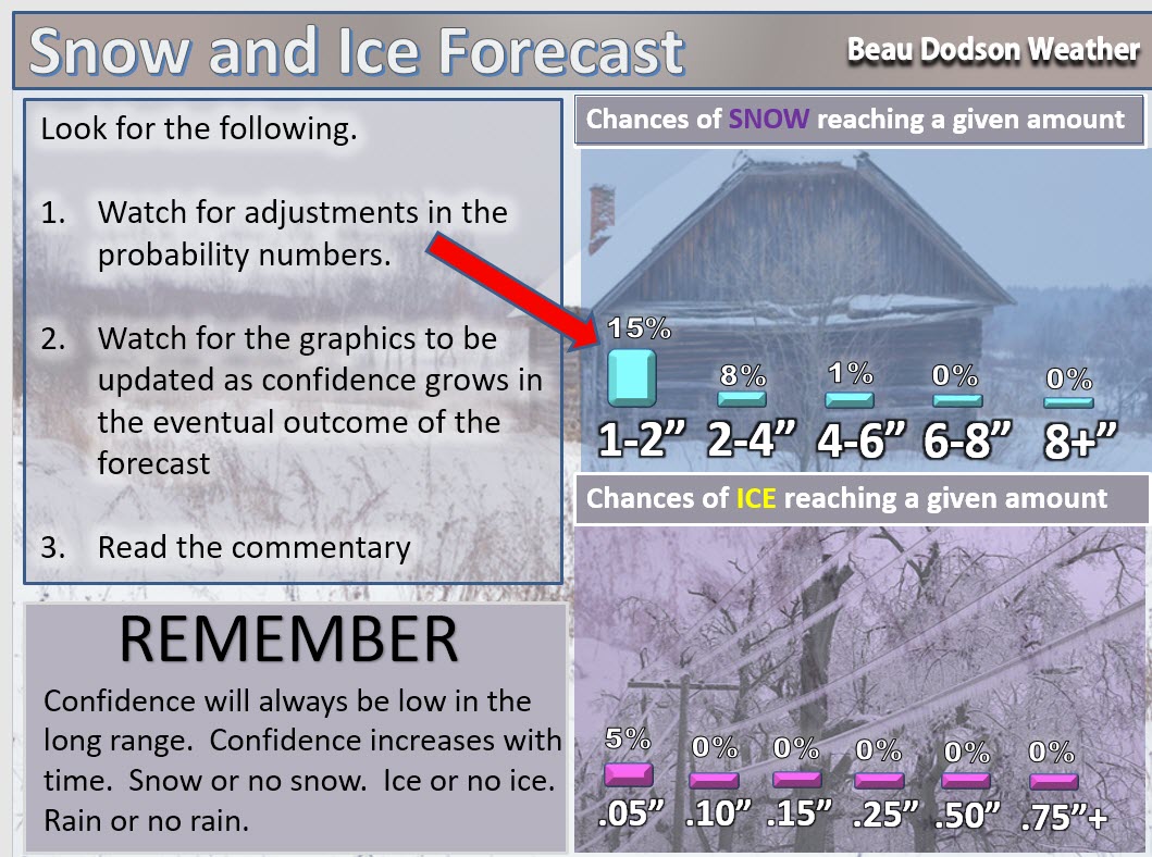
Winter storm forecasting is difficult 12 to 24 hours in advance, let alone days in advance. Don’t skim the graphics. Read the commentary and actual forecast thoughts.
What you read here is for planning purposes only. There can be and often are wild fluctuations in model guidance past two or three days. Again, keep this in mind. Don’t say “Beau said it is going to snow on Thursday”
Confidence on snow events, past two or three days, is typically going to be low. Again, forecasters can not accurately predict snow totals more than 12 to 24 hours in advance.
Low confidence means significant adjustments are possible in the forecast.
Welcome to the winter weather outlook

An explanation of what is happening in the atmosphere over the coming days.
Do you need the day to day forecast? If so then you will want to visit the regular blog page. Here is the link – Click here.
Don’t focus on specifics when it comes to the long range outlooks!
What is important is always the pattern when it comes to long range forecasting. There is not a meteorologist in the country that can accurately predict detailed snow forecasts weeks in advance. Not going to happen.
I can show you the overall pattern.
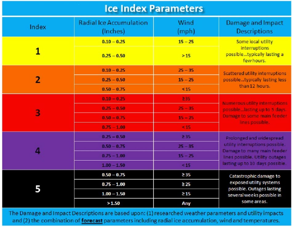
What to take from these maps:
The winter weather update is issued twice each week. It is updated daily during winter weather events (leading up to the events).
.
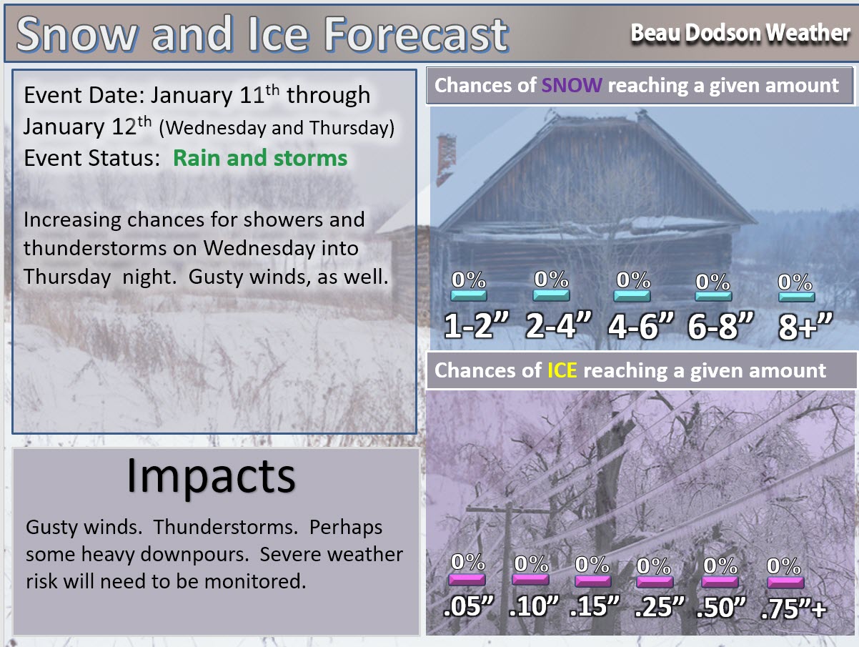
Updated 3 PM January 12, 2017

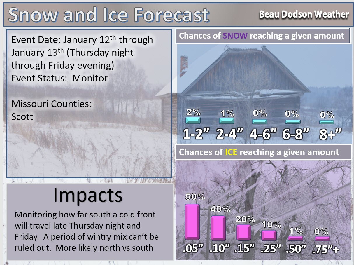
Wednesday, January 11th through Thursday night, January 12th
Concern: Showers and perhaps some thunderstorms. Gusty winds.
Impact? Wet roadways. Perhaps lightning. Monitor the thunderstorm part of the forecast.
Risk: High There is a high risk for rain and storms with this event.
Confidence level in this forecast. One being the lowest confidence level. Ten being the highest confidence level.
Confidence level on rain occurring Wednesday into Thursday night (on and off rain).
Confidence level: 10 Rain is likely to occur.
Risk: of severe thunderstorms occurring with this event
Risk: Low risk. Monitor updates.
Lightning is possible. Severe weather risk appears low.
There will be some instability in our region on Thursday and Thursday afternoon/evening. Some thunderstorms are likely to occur. I will monitor the severe weather potential. The risk is low, but not zero.
Risk: of wintry precipitation on Wednesday through Thursday evening.
Risk: Low risk It is unlikely that wintry precipitation will occur on Wednesday through Thursday evening. Wintry weather is likely for portions of our region Thursday night into Friday. Monitor watches and warnings.
Confidence level in this forecast: on a scale from 1 to 10. One being the lowest confidence level. Ten being the highest confidence level.
Confidence level: 8 It appears unlikely that wintry precipitation will occur on Wednesday into Thursday evening. Thursday night into Friday, however, will have a risk for some freezing rain and sleet over portions of the region. Not everywhere, but portions.
Milk and Cookies with Beau winter weather Q&A: No.
.
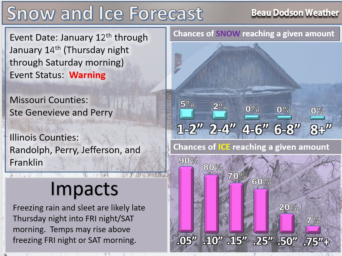
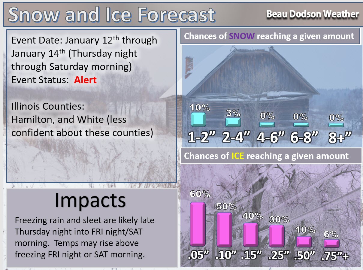
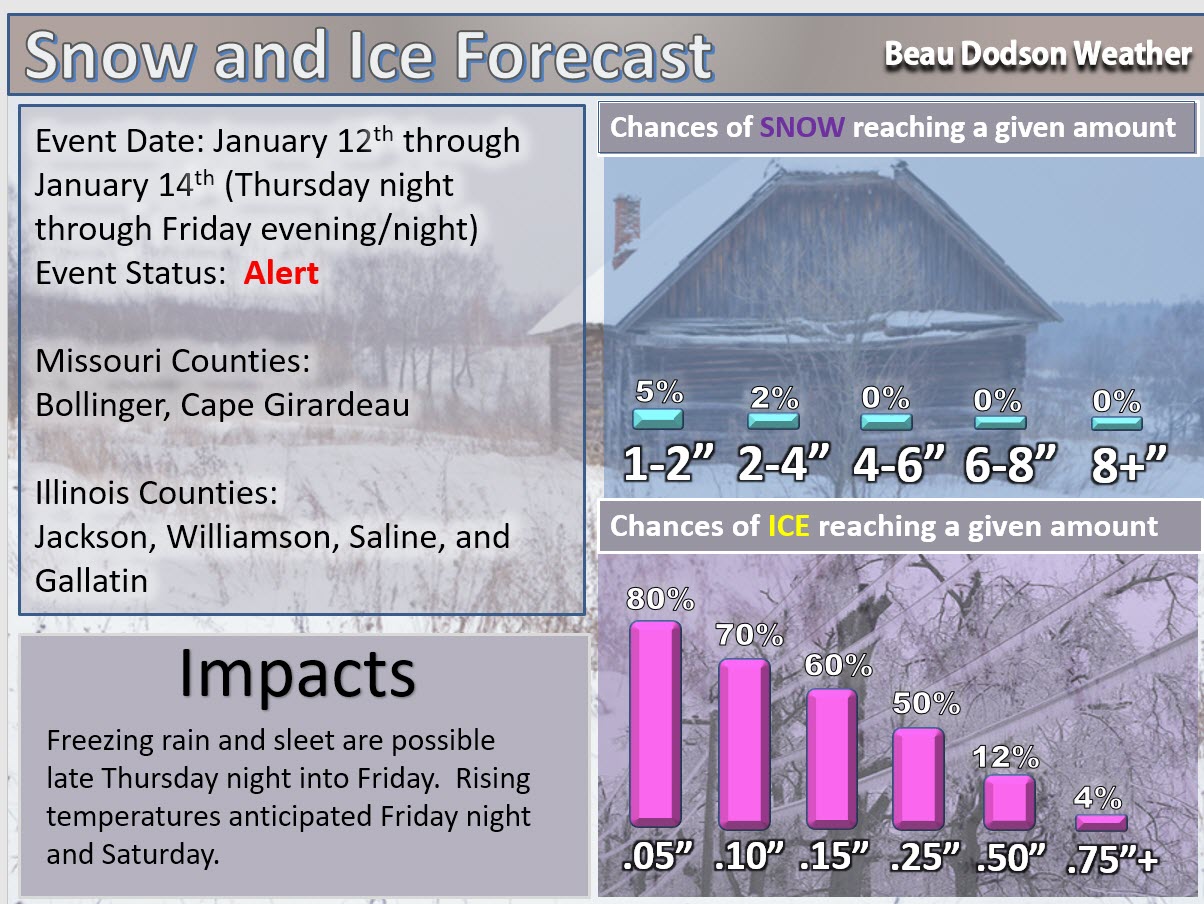
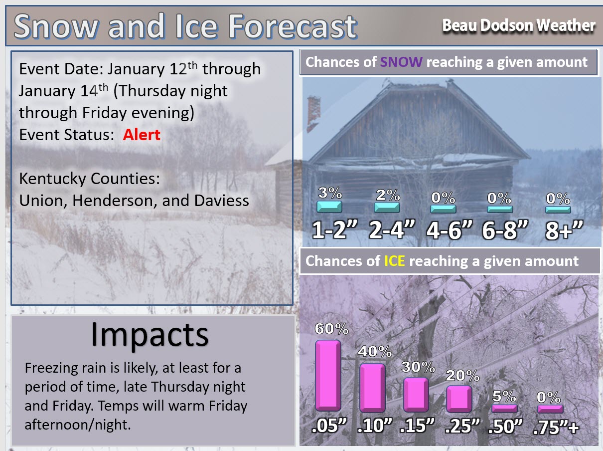
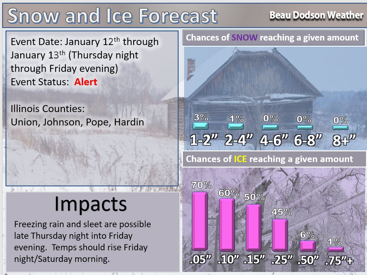
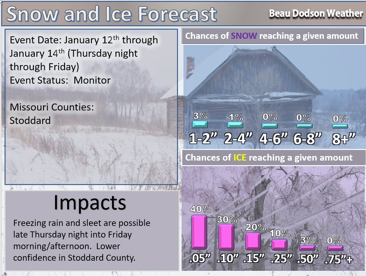
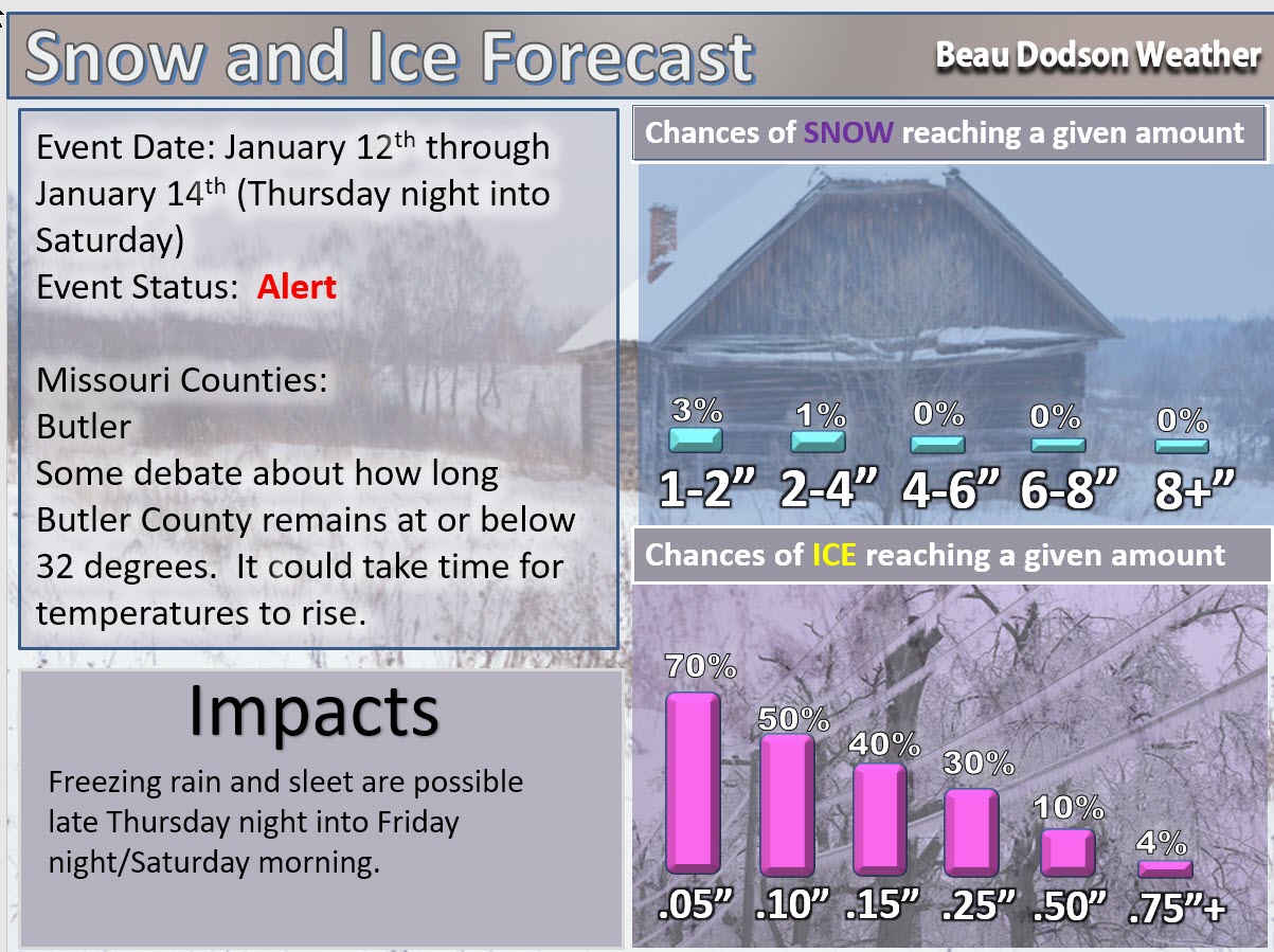
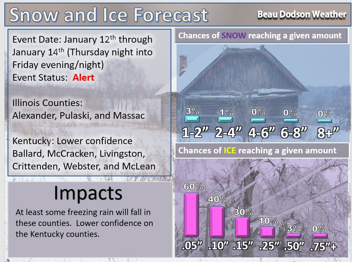
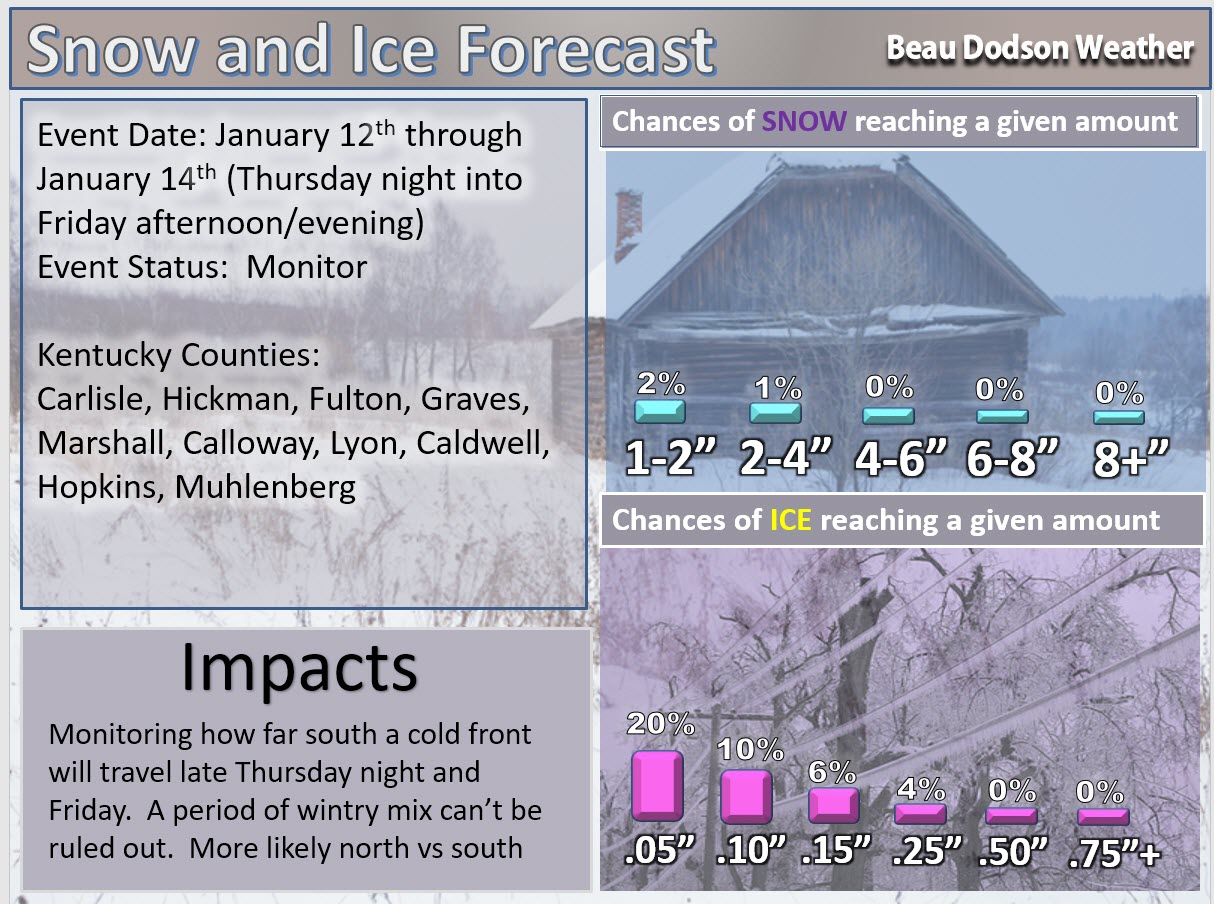
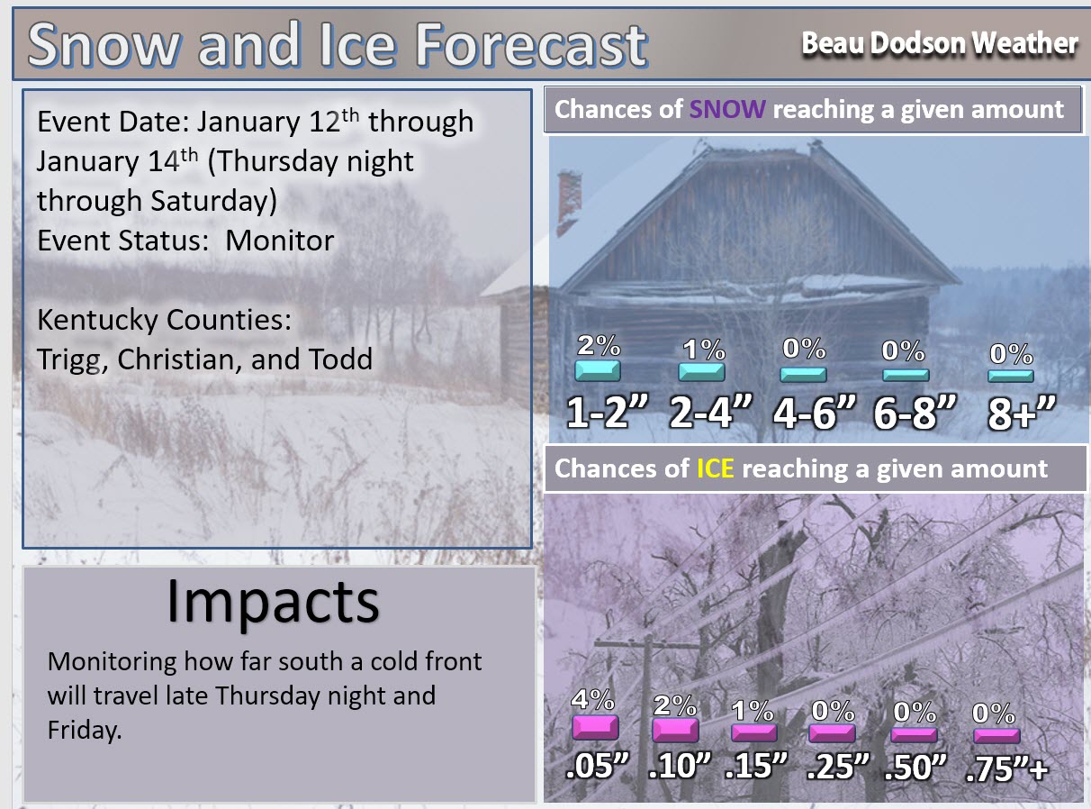
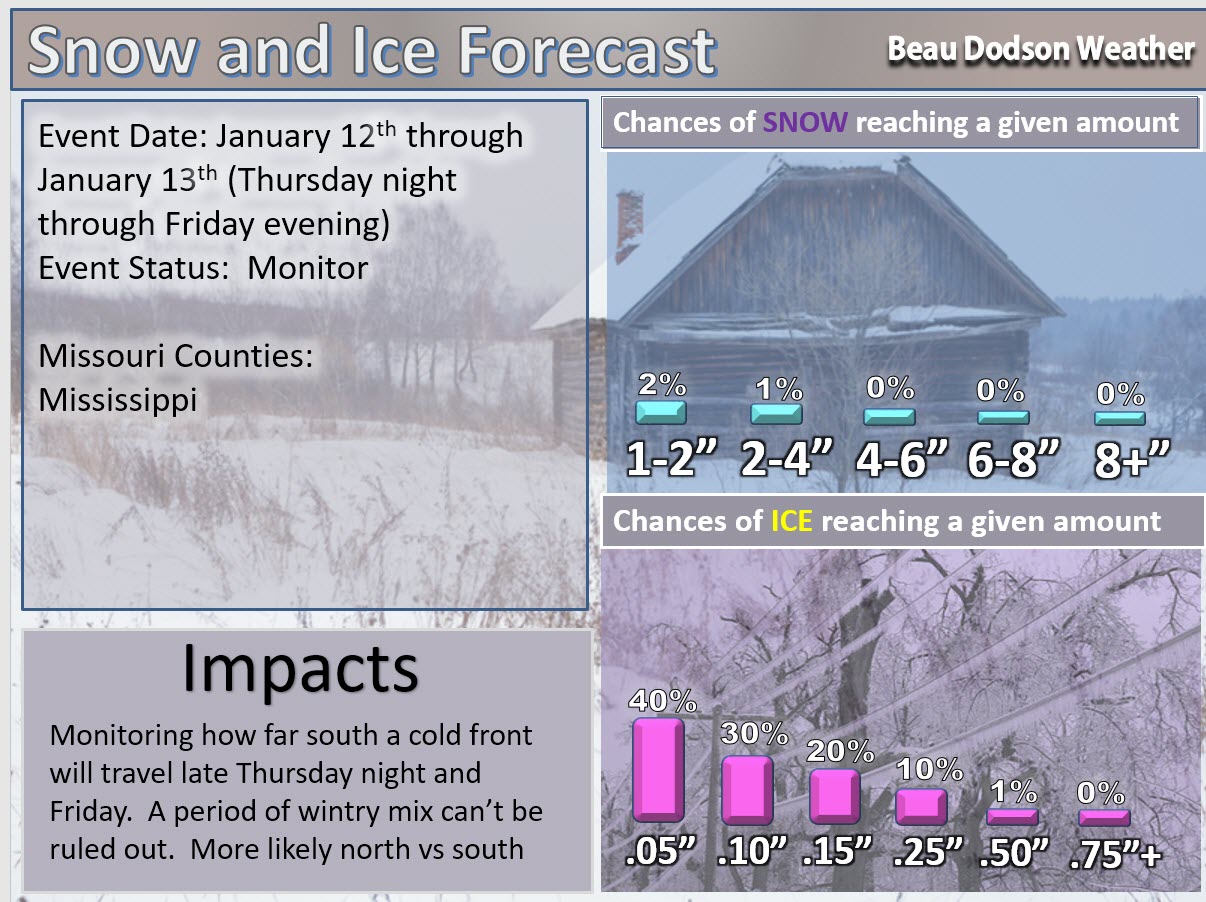
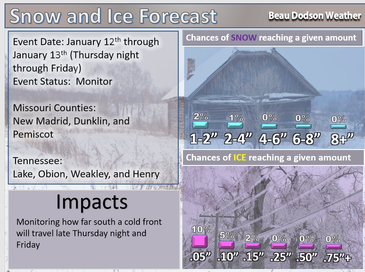
Thursday night, January 12th through Saturday, January 14th
Some icing concerns for portions of southeast Missouri and southern Illinois. Light accumulations of freezing rain anticipated. Totals less than 0.25″ are expected. Portions of northwest Kentucky may also have issues.
Less confidence for areas along the Ohio River.
There will be lulls in precipitation. This also raises questions on totals and duration of the event. Warm road and warm ground conditions might offset some of the ice accumulation.
Highest risk will be over southeast Missouri and southern Illinois. Areas further south should monitor updates.
Concern: Complex overrunning precipitation event. This will need to be monitored. These type of events can produce quite a bit of precipitation. There are hints in the guidance that a front may stall over our region (or near our region).
Impact? Wintry precipitation could cause some ice buildup on trees and power lines. Some roads may become icy.
Risk: High. There is a high risk that precipitation will occur Thursday night into Sunday.
Confidence level in this forecast. One being the lowest confidence level. Ten being the highest confidence level.
Confidence level on some precipitation occurring Thursday night into Sunday.
Confidence level: 10
Risk: of severe thunderstorms occurring with this event
Risk: At this time, the risk is low
I am currently not anticipating severe thunderstorms on Thursday night into Saturday. As always, monitor updates.
Risk: of wintry precipitation late Thursday night into portions of Saturday
Risk: High risk There is a high risk of freezing rain and sleet late Thursday night into Friday night/Saturday morning over portions of our region. There could be a wide range of precipitation types from north to south. A boundary will be near our region. Temperatures may fall into the 20’s and 30’s north of the boundary and 40’s and 50’s south of the boundary. A complex forecast. Monitor updates.
Confidence level in this forecast: on a scale from 1 to 10. One being the lowest confidence level. Ten being the highest confidence level.
Confidence level: 9 There is high confidence that at least some portion of the region will experience a wintry mix on Thursday night into Saturday.
Let’s break it down by counties.
Milk and Cookies with Beau winter weather Q&A: Yes. 7 PM (Thursday night) on The Beau Dodson Weather Facebook page
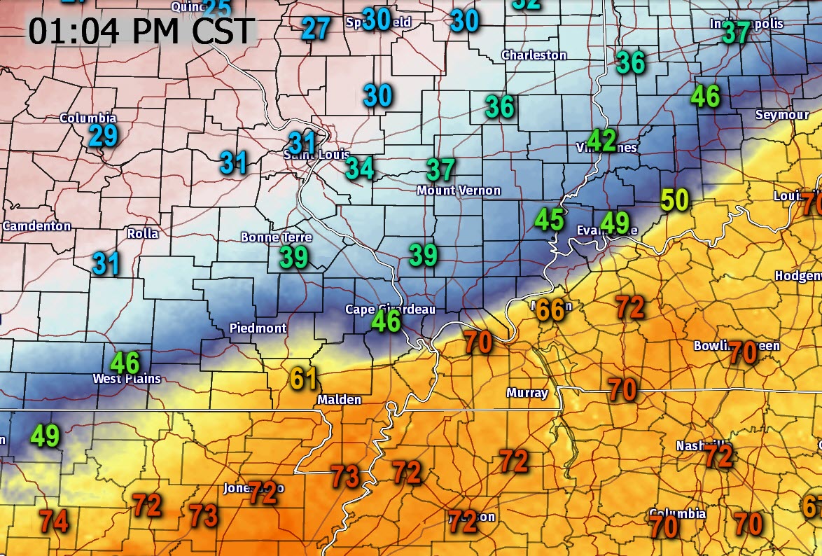
A strong cold front/stationary front is pushing through the region. Temperatures to the north of the boundary have fallen into the 20’s and 30’s. South of the boundary temperatures are warmer.
Here is the 1 PM temperature map. Wow, what a change! Many areas have witnessed 20 degree temperature drops in a matter of minutes.
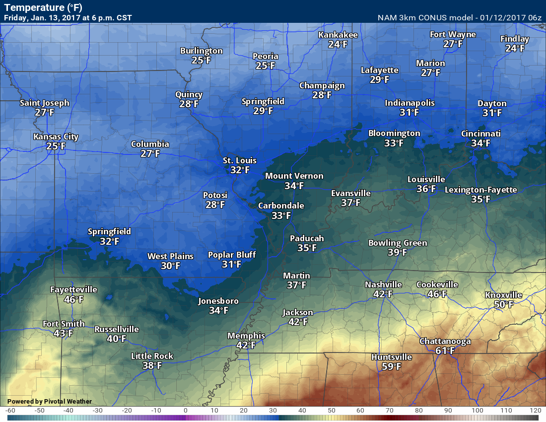
Here is the 6 AM and 6 PM temperature maps for Friday. Tricky forecasting on exactly where the 32 degree line will settle. Then the question becomes how fast does it move north on Friday afternoon and night.
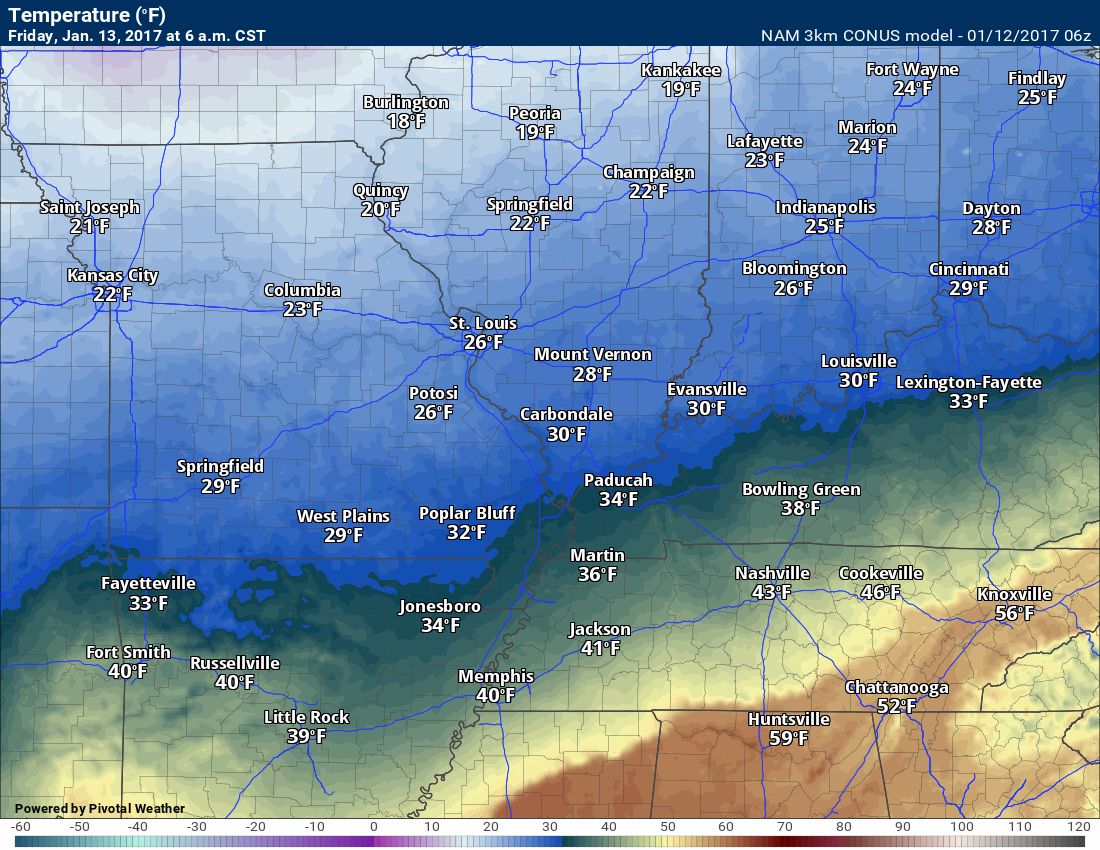
and
The boundary will sharpen late Thursday night into Friday. At the same time, south and southwesterly flow at the surface and aloft will ride up and over the front. This will trigger some precipitation along the front.
Where the boundary stalls is key to precipitation type in our region.
At this time, the probabilities favor portions of Missouri and Illinois dipping below freezing on Thursday night into part of Friday night. Beyond Friday night the temperatures should start to rise above freezing. This will need to be closely monitored.
Areas further south should monitor updates. Models do not have a handle on where the 32 degree line will eventually settle.
It should end up near the Ohio River. Within one county north or south. That is the current forecast. Again, monitor updates.
Freezing rain and sleet are forecast to occur north of the boundary. Most likely freezing rain. Perhaps a little sleet. No snow anticipated.
Models are showing 1 to 2 inches of freezing rain. The problem with models is that they don’t actually forecast anything. They just show you numbers. Typically, I cut the ice totals in half. That would mean 0.50″ to 1″ of freezing rain for some areas.
My thoughts today (Thursday afternoon) are that a trace to 0.20″ of freezing rain will be the eventual outcome. I can not completely rule out the Missouri Ozarks into parts of southern Illinois receiving 0.25″ to 0.30″. That would likely be the exception and not the rule. As always, monitor updates.
As always, monitor updates. Any changes in the position of the front could change forecast details.
Here is what X amount of freezing rain can do to power lines and trees. This is a light event.
Click image to view higher resolution
Again, my forecast is for a trace to perhaps 0.20″ with pockets of slightly higher possible.
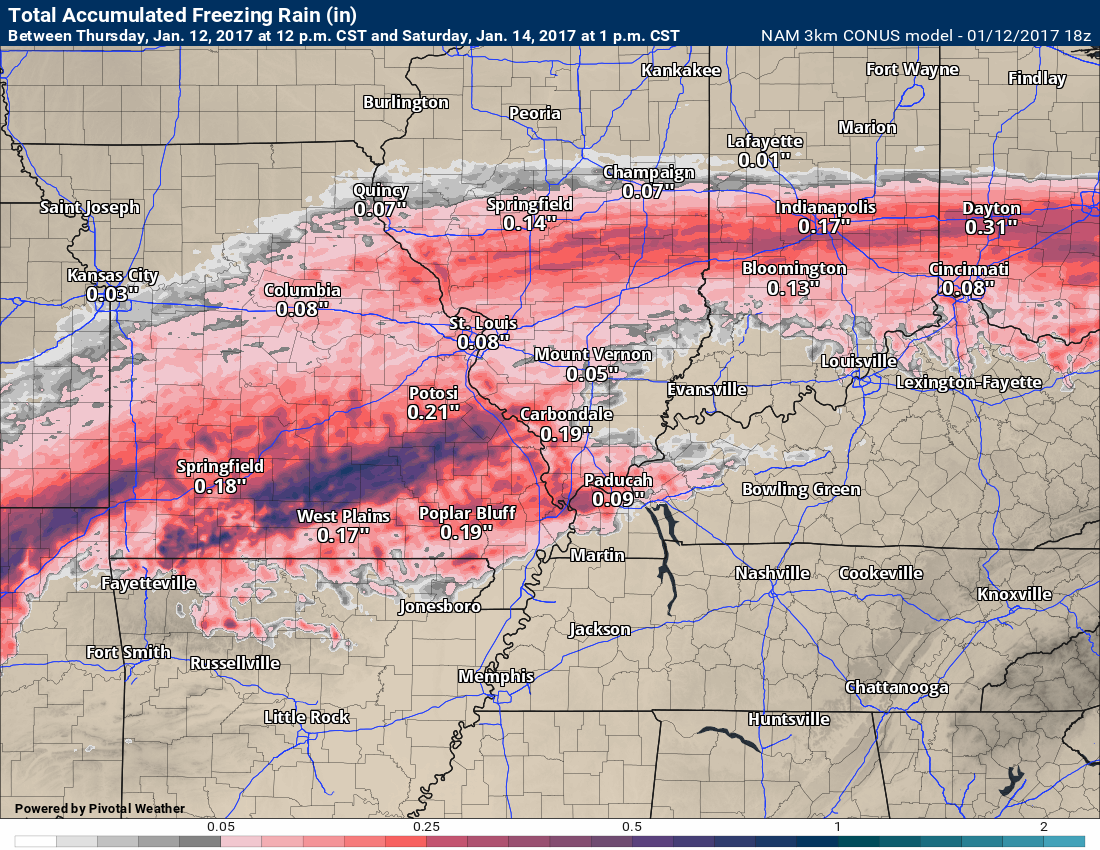
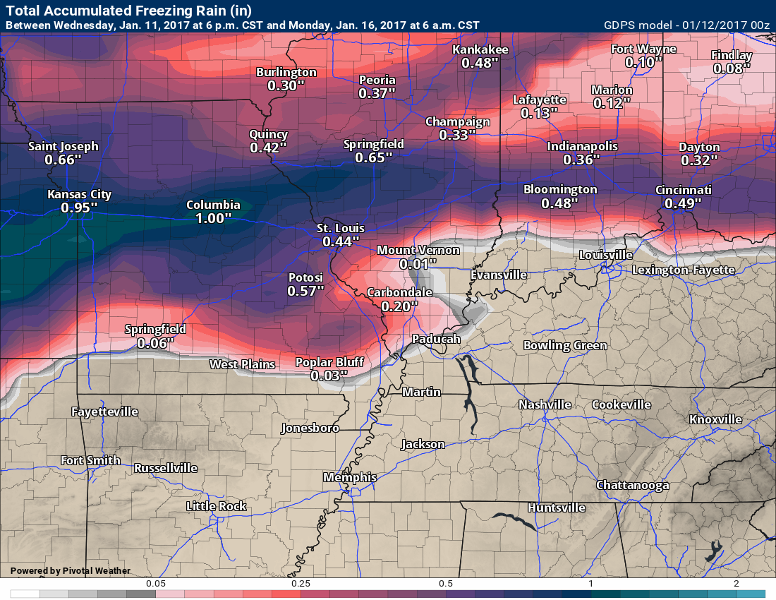
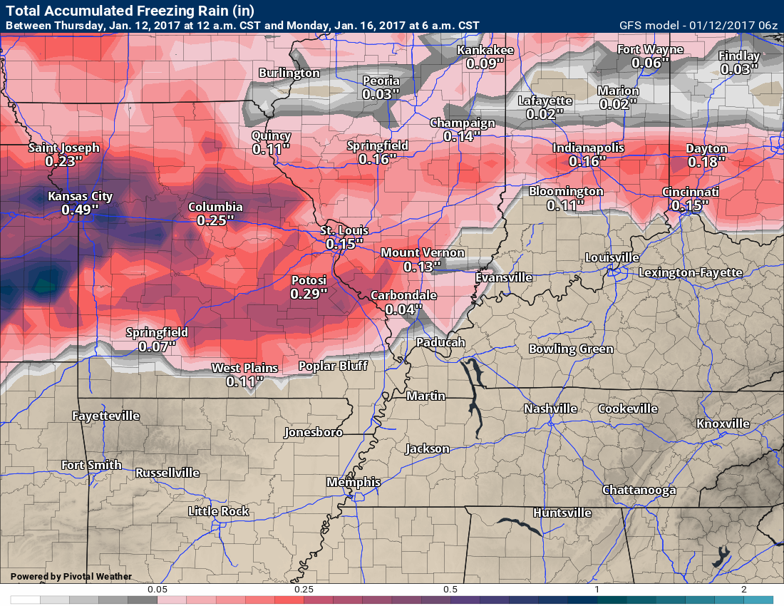
Let’s look at freezing rain amounts on the model guidance.
Again, I typically cut these by 50%-60%. There are other factors that come into play, as well. You can’t just look at these maps and say X amount of freezing rain is going to fall at a certain location. It does not work that way. I have witnessed a lot of maps floating around on Twitter and Facebook. They are deceptive, at best.
Here is the NAM guidance.
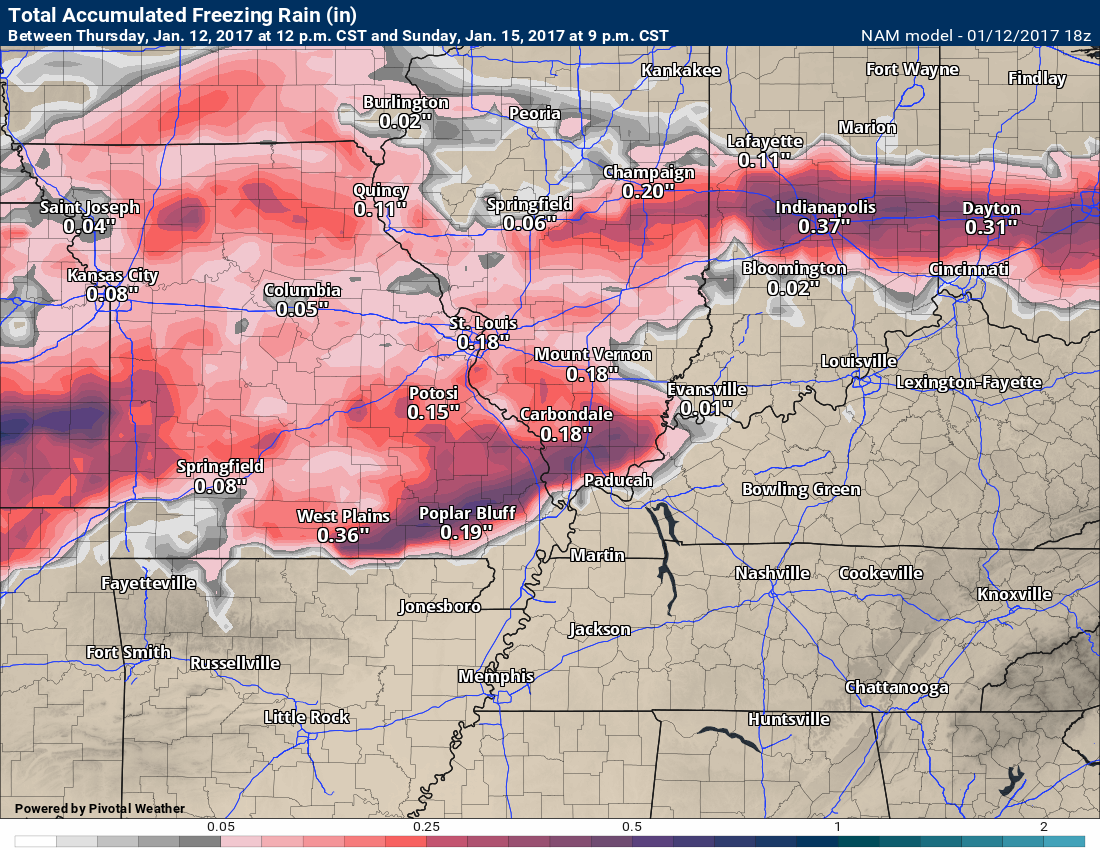
Here is a higher resolution NAM model
Notice portions of the area do not receive much ice. Parts of SE IL are in question on the NAM guidance. Keep that in mind.
Here is the GEM guidance. It shows freezing rain over much of our region
The GFS, on the other hand, paints the ice further north.
The NWS has started to update on this event, as well.
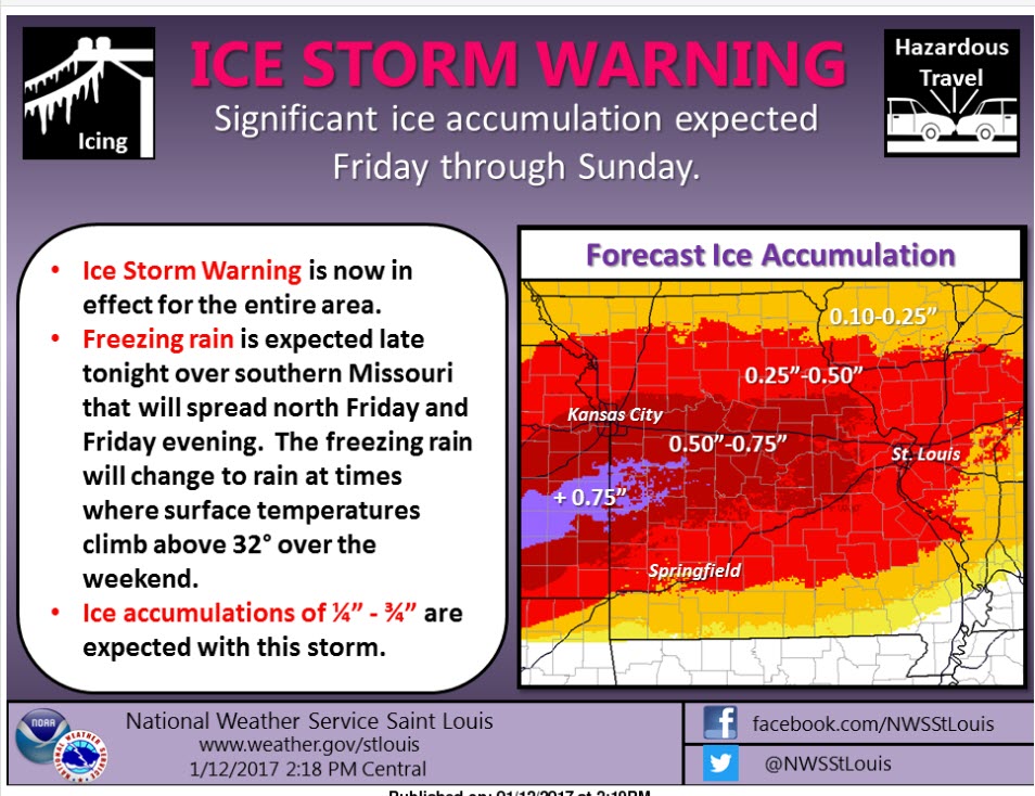
Here is the St Louis, MO National Weather Service forecast totals
What is anticipated
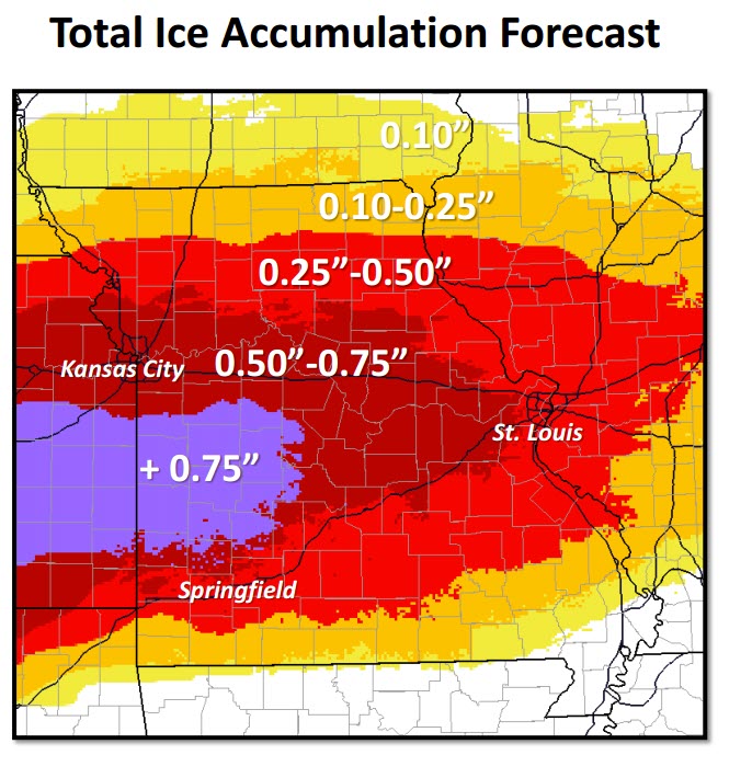
The NWS has also started to issue advisories and warnings. Here was their 2 pm map
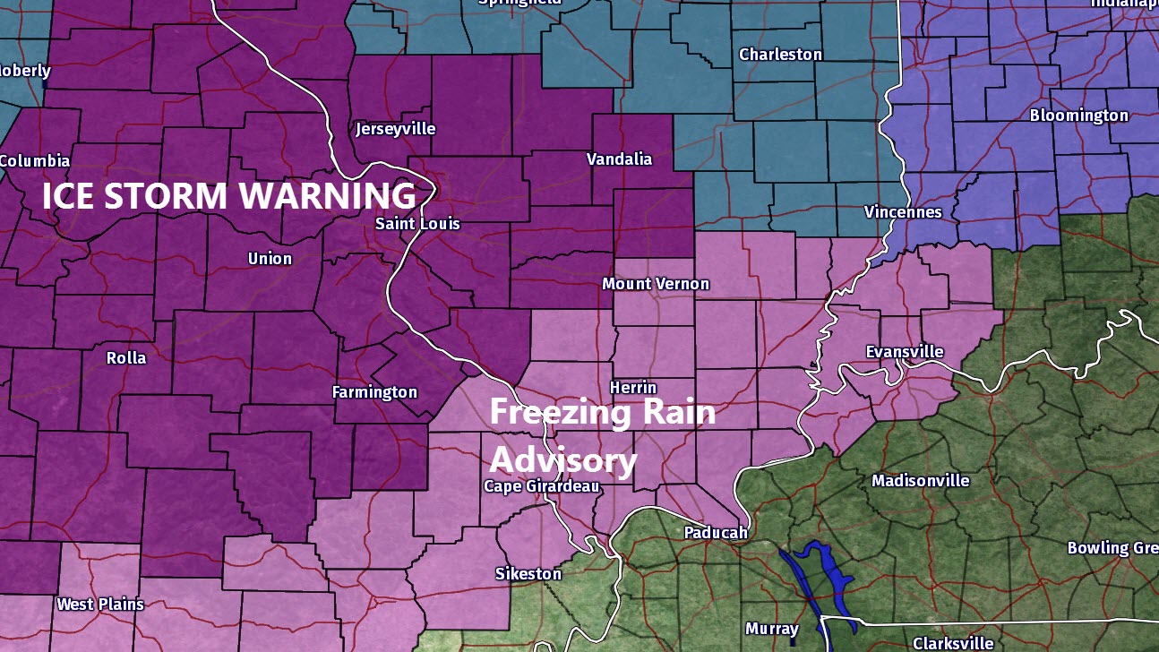
The St Louis, MO NWS office issued this graphic
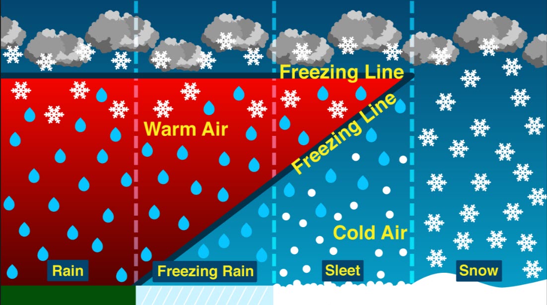
What determines precipitation type? That is a great question! It is complex.
Temperatures aloft are partly responsible for precipitation type at the surface. This is why you can experience freezing rain with temperatures in the teens. With temperatures in the teens you would think it would snow! Not always.
Warm air aloft will melt snowflakes. Once a snowflake melts it can never become a snowflake again. It can, however, turn to a pellet of sleet (water that has frozen on the way to the ground).
If the warm layer aloft is deep (but temperatures at the surface are at or below freezing) then odds favor freezing rain. If the warm layer aloft is shallow then odds favor sleet. If the temperature from the surface all the way up into the atmosphere is below freezing then you should experience snow.
Unfortunately, our region often finds itself caught in the middle of precipitation type. It is not uncommon for rain to fall in Union City, Tennessee while snow is falling in Carbondale, Illinois.
The event on Friday and Saturday will, for a period of time, have a deep warm layer. That is why freezing rain is forecast. Other precipitation types are also possible.
Here is a graphic that explains what I talked about above. Notice the depth of the warm layer from rain to snow.
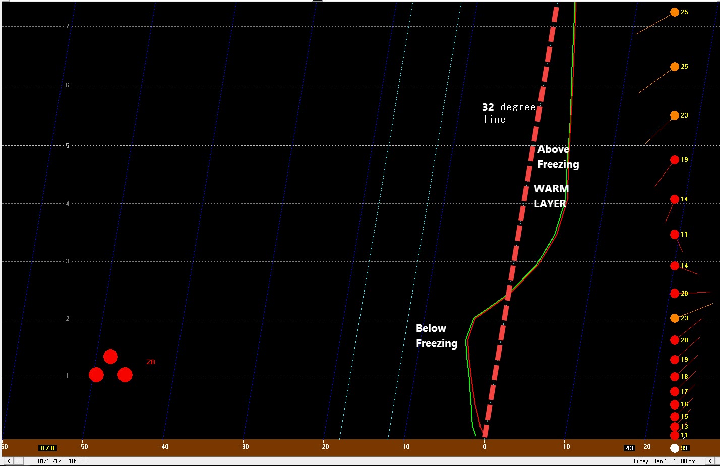
Here is a sounding from Carbondale, Illinois on Friday.
The bottom of the graphic is where you live. Ground level. The higher you go up on the chart the higher into the atmosphere you have traveled.
Notice the dotted red line? That is the freezing line from the surface all the way up into the atmosphere. Part of the atmosphere is above freezing. That is a warm layer aloft. That will melt snowflakes. It is cold at the surface. Thus, freezing rain or sleet is the favored precipitation type (for a brief period of time).
Here is my current forecast
Updated at 3 PM on Thursday, January 12th

We have regional radars and local city radars – if a radar does not seem to be updating then try another one. Occasional browsers need their cache cleared. You may also try restarting your browser. That usually fixes the problem. Occasionally we do have a radar go down. That is why I have duplicates. Thus, if one fails then try another one.
If you have any problems then please send me an email beaudodson@usawx.com
CLICK WINTERIZE on the interactive radars to see where snow, sleet, freezing rain, or rain is occurring. If you don’t click winterize then you won’t see everything.
WEATHER RADAR PAGE – Click here —
We also have a new national interactive radar – you can view that radar by clicking here.
Local interactive city radars include St Louis, Mt Vernon, Evansville, Poplar Bluff, Cape Girardeau, Marion, Paducah, Hopkinsville, Memphis, Nashville, Dyersburg, and all of eastern Kentucky – these are interactive radars. Local city radars – click here
Regional Radar

I have placed Alert’s on some of the counties. That simply means that confidence in a wintry mix at or above 50%. That does not include impacts. In other words, just because freezing rain falls from the sky does not mean the roads will become slick. Again, since roads are warm, this is a big question mark..
I can tell you the forecast. I am not forecasting road conditions.
Winter storm watches, warnings, and freezing rain advisories (other) are already being issued for portions of the region. Monitor those here
WATCHES and WARNINGS MAP CLICK HERE
5:20 PM THURSDAY VIDEO UPDATE
Here are the county by county numbers.
Impacts will vary. There remain questions on how much frozen precipitation will accumulate on surfaces. There remain questions on road temperatures (remember, we will experience temperatures in the 60’s/70’s before this event).
Updated Thursday at 3 PM
Definitions:
Sleet: Little pellets of ice that bounce when they land on your car or sidewalk.
Freezing rain: Freezing rain is rain that immediately freezes on contact with surfaces. Freezing rain is what cause power lines and trees to droop under the weight of the ice.

Thursday night into Friday night: On and off precipitation chances. Freezing drizzle or freezing rain possible in the ALERT zone on Thursday night (late) into Friday. Some question on coverage of precipitation. Expect at least some freezing rain in the region.
Temperatures on Friday night into Saturday should rise from south to north. Temperatures are likely to go above freezing area-wide by late Friday night or more likely Saturday.
Want to preview additional precipitation events over the coming weeks?
Here is the previous outlook that includes those graphics. Click here The password is frosty
January and February forecast for temperatures
Let’s break it down using the Gary Lezak long range recurring forecast theory/numbers
Again, confidence is always low on this type of forecast. It is more for fun and interest than anything else. Do not make plans according to these forecast numbers.
January 9th through January 11th: Above normal temperatures
January 11th through January 14: Changeable temperatures with a boundary near our region. Temperatures will fluctuate.
January 15th through January 19th: Colder than normal
January 20th into January 22nd: Changeable anomalies
January 23rd through January 26th: Below normal temperatures
January 27th through January 28th: Above normal temperatures
January 29th through January 31st: Below normal temperatures
February 1st through February 14th: Mostly below normal temperatures with a few days of above normal temperatures.
February 15th through February 25th: Above normal temperatures. A couple of below normal temperature days.
February 26th through February 28th: Below normal temperatures
Current indications are that above normal precipitation may occur during the spring months.
Perhaps a continuation of the December and January pattern. Frequent systems to track.
Winter weather disclaimer.
This is a long range forecast. That means confidence is low as to the eventual outcome. Keep that in mind. Meteorologists have a hard enough time forecasting snow 24 hours in advance let alone days or weeks in advance.
If you want to read my philosophy, on long range forecasting, then I will point you to this article – Click Here
Long range forecasting is a little bit of skill and a lot of luck. The skill level dramatically decreases once we move past week one.
This next paragraph is Meteorologist John Dee’s comments on long range forecast. I agree with him.
I would like to start out by trying to differentiate between seasonal forecasting and weather forecasting for the next week or so.All weather forecasting involves a percentage of guessing. A forecast for the next 24-48 hours might be 90% science and 10% guesswork, and by the time you are trying to forecast for days 7, 8, 9 and 10, the percentages might be more like 50% science and 50% guesswork. By the time you get into seasonal forecasting, there is little proven science and methodology behind those forecasts- at least methods that truly work. Most seasonal forecasts are really just creative writing using meteorological terms! End of his comments.
End of his comments.
Winter is defined as December through February.
How do weather app’s know the forecast for anywhere in the world? Why does my weather app say heavy snow in two weeks?
These are questions that I receive on a regular basis. It is important to remember the weather app’s (for the most part) are computer-generated forecasts. There are a few app’s that allow tv stations to edit the forecast. Most, however, do not.
Why not to trust your cell phone app’s weather forecast.
App’s are, for the most part, not human based forecasts. They are simply spitting out what one computer model says. This is why the forecast on your app changes every few hours. Do not trust app’s. I call them cr’apps.
The link to the daily (free blog) is this talk.weathertalk.com
You can also check my Twitter feed (@beaudodson) and the Beau Dodson Weather Facebook page.
Remember, models are not forecasters. Models are nothing more than a set of algorithms/numbers turned into a pretty map. There is no interpretation by a human. They are for guidance only. People who post these maps are not issuing a forecast. They are just showing you the most extreme snowfall map they can find. Some of us in the weather business call this click bait.
What is click bait? It is showing people incredible snowfall maps with outrageous headlines. This happens in the spring, as well. In the spring it is normally a headline that reads BIG TORNADO OUTBREAK FORECAST. Then the details show the system is 5, 6, 7 or more days away. This serves only to scare people or upset them.
My advice, don’t share those posts or pages. Check with your trusted weather sources. See what they are saying. Your trusted weather sources are always going to be monitoring the situation. A forecast should ramp up and not down.
What does ramp up and not down mean? It means you don’t tell people that 8″ of snow will occur seven days down the road. You start out by mentioned a possible system down the road, but the details are not specific and it is too early for an accurate forecast. As time progresses, the confidence in what will happen will grow. It is at that time that you start to ramp up the rhetoric.
Occasionally the snow maps are correct, but most of the time they are not.
Snow can not be accurately forecast days in advance (with any confidence). Meteorologists do well to forecast snow accumulations within the 24 hour mark. I have witnessed snow forecasts bust WHILE it is snowing. What does bust mean? It means the forecast busted/did not verify.
Definitions:
Analogs: Analog forecasting is based on looking at previous years and trying to find a similar match to current conditions. This can help forecasters determine probabilities of X, Y, and Z happening. Weather repeats itself. Finding the match is what is difficult.
Arctic Outbreak: Bitterly cold air that moves from the arctic into Canada and then into the United States. These cold outbreaks are responsible for temperatures below zero to lower teens in our region.
Clipper: An Alberta clipper (also known as a Canadian Clipper) is a fast moving low pressure area which generally affects the central provinces of Canada and parts of the Upper Midwest and Great Lakes regions of the United States, precipitating a sudden temperature drop and sharp winds.
Ensembles: See below for a longer explanation. Ensembles are models that are run multiple times with slightly different variables. The more agreement among the ensemble guidance the higher the confidence in the eventual outcome of weather conditions.
GFS: An American model. Medium to high skill model.
GEM: A Canadian model. Medium skill model.
NAM & WRF: An American short range model. High skill level.
EC: A European model. High skill model.
CFS-2: An American model array used for long range forecasting. Low to medium skill model.
Guidance: Another word for models.
Isobars: Equal lines of pressure. Tightly packed isobars typically mean windier conditions.
Low pressure: Typically associated with rain or snow. Unsettled weather.
Canadian High Pressure: Typically associated with cold to bitter cold temperatures.
Models: Models are what forecasters use for guidance when issuing a forecast. Models alone do not forecast the weather. They offer guidance when making forecast decisions.
Pattern: The general weather conditions in the long range.
Trends: What direction is the guidance moving. Warmer? Colder? Track of the low further north of south?
Short range: One to three days into the future.
Medium range: Four to six days into the future.
Long range: More than six days into the future.
What are ensembles?
There are two types of models. There is what we call the control/operational run and there are ensembles. Ensembles give you a spread. They show you different possible solutions. The more ensemble members agree the better the chance the forecast will verify.
For example, let’s say I run the GFS model ten times. Each time with slightly different variables. Once finished, eight of the ten model runs show rain next Wednesday. That means you have a higher than normal confidence in the eventual outcome of the weather conditions. It does not mean the model will always be correct. It just adds to the confidence level.
The EC model is for Medium-term Weather Prediction, the operational model is re-run at a lower resolution (than the control run) and this is then repeated 50 times, each with slightly different starting conditions.
Don’t focus on specifics when it comes to the long range outlooks!
NOT specifics. What is important is always going to be the pattern when it comes to long range forecasting. There is not a meteorologist in the country that can accurately predict detailed forecasts weeks in advance. Not going to happen.
What we can do is show you the overall pattern. That gives us a general idea of what might happen.
Remember, it is not uncommon to have wild fluctuations in what the models show past week one. In other words, these maps can change from run to run. Most computer models are updated four times each day.
.
Here is the official 6-10 day and 8-14 day temperature and precipitation outlook. Check the date stamp at the top of each image (so you understand the time frame).
The forecast maps below are issued by the Weather Prediction Center (NOAA).


The latest 8-14 day temperature and precipitation outlook. Note the dates are at the top of the image. These maps DO NOT tell you how high or low temperatures or precipitation will be. They simply give you the probability as to whether temperatures or precipitation will be above or below normal.


Have you switched phone carriers?
If you have recently switched phone carriers then be sure and adjust your Weather Talk account settings. Just click on the My Personal Notification Settings tab. You will then see the pull down menu with different phone carriers. Choose the one that best fits your phone (ATT, Verizon, and so on).
Updated PayPal or credit cards.
Don’t forget to update your credit card information if you have a new card. You can do that by clicking on the My Account tab and then click the second green button. The same applies to PayPal.
Your support helps cover costs. Each month I have at or more than $700 in expenses. That is my out of pocket expenses. Don’t forget the proceeds also help with the Shadow Angel Foundation projects. You can view those projects at this link – Click Here.

Invite Your Friends!
Be sure and invite your friends to sign up for the Weather Talk text messages. Remember, there are four text messages you can choose from.
You can adjust your account settings whenever you like.
The first text message option is the most important one. The severe weather text messages. I send these out during severe thunderstorms, tornadoes, and winter storms.
The second text message option is the daily weather forecast. Typically this is updated between 12 pm and 4 pm each day. You will receive the forecast for tonight and tomorrow. They will arrive as two messages. This is because of limits on how many characters can be sent in a text. I am also hand typing them.
The third text message option is the social media texts for severe weather/winter storm days. I will send you the latest link to videos, the blog, and the Facebook threads.
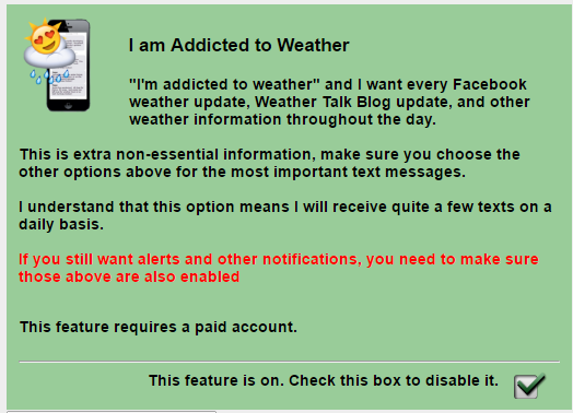
The fourth text option (does NOT replace any of the other three) is for non-severe weather day social media links. I will send you a link to the latest video, blog update, Facebook thread, and winter storm outlooks. Again, this text option does NOT replace the other three. You still need to select the other three (or whichever ones you wish to receive).
Here is what the four text message options look like on the Weather Talk website (under the My Personal Notification Settings tab).
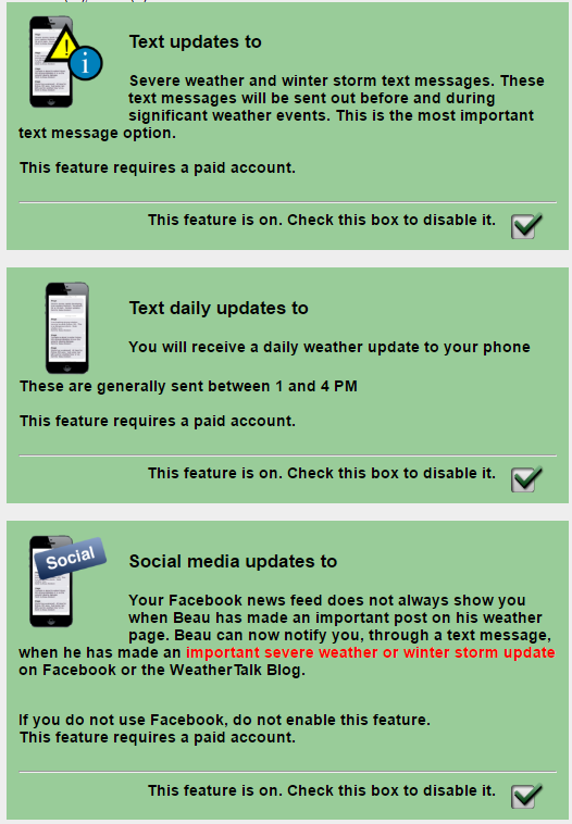
and the fourth one (which does not replace the other three)