
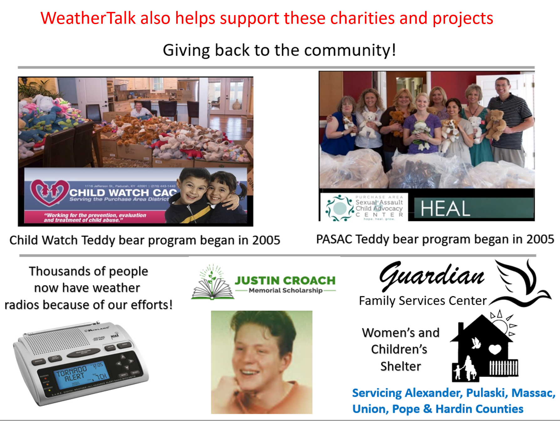
Did you know that your WeatherTalk subscription helps support numerous local charity events?
Check them out at these links
The Justin Croach Memorial Scholarship
Daily WeatherTalk schedule

We offer interactive local city view radars and regional radars.
If a radar does not update then try another one. If a radar does not appear to be refreshing then hit Ctrl F5. You may also try restarting your browser.

Interactive Radars:
Interactive live weather radar page. Choose the city nearest your location. If one of the city radars won’t load then try a nearby one. Click here.
Live GOES 16 Satellite views. Click here
December 22, 2018
Saturday forecast: Partly sunny. Cool.
My confidence in the forecast verifying: High (80% confidence in the forecast)
Temperature range: MO ~ 48 to 52 IL ~48 to 52 KY ~ 48 to 52 TN ~ 48 to 52
Wind chill (feels like) temperature forecast: 45 to 50
What is the chance/probability of precipitation? MO ~ 0% IL ~ 0% KY ~ 0% TN ~ 0%
Coverage of precipitation: None
Is flooding anticipated? No
Is accumulating snow or ice anticipated? No
Is non-accumulating snow or ice anticipated? No
Are icy road conditions anticipated? No
Wind direction and speed: West and northwest at 5 to 10 mph. Wind becoming south and southwest.
What impacts are anticipated from the weather? None
Is severe weather expected? No
The NWS officially defines severe weather as 58 mph wind or great, 1″ hail or larger, and/or tornadoes
Will lightning be possible? No
Should I cancel my outdoor plans? No
Will the weather impact my outdoor plans? None
UV Index: 2 Low
Sunrise: 7:06 AM
Saturday Night Forecast Details:
Forecast: Mostly clear and chilly early. Increasing clouds late. A chance of a late-night shower or snow shower.
My confidence in the forecast verifying: Medium (60% confidence in the forecast)
Temperature range: MO ~ 28 to 34 IL ~ 28 to 34 KY ~ 30 to 34 TN ~ 30 to 34
Wind chill (feels like) temperature forecast: 25
What is the chance/probability of precipitation? MO ~ 10% IL ~ 10% KY ~ 30% TN ~ 30%
Coverage of precipitation: Isolated
Is flooding anticipated? No
Is accumulating snow or ice anticipated? No
Is non-accumulating snow or ice anticipated? Perhaps
Are icy road conditions anticipated? No
Wind direction and speed: Southwest and west at 5 to 10 mph. Wind becoming northwest.
What impacts are anticipated from the weather? A few wet roadways.
Is severe weather expected? No
The NWS officially defines severe weather as 58 mph wind or great, 1″ hail or larger, and/or tornadoes
Will lightning be possible? No
Should I cancel my outdoor plans? No
Will the weather impact my outdoor plans? None
Sunset: 4:41 PM
Moonrise: 4:57 PM Full
Moonset: 6:48 AM
December 23, 2018
Sunday forecast: Cloudy. Cold. Breezy. A chance of rain showers mixed with snow and sleet showers.
My confidence in the forecast verifying: Medium (60% confidence in the forecast)
Temperature range: MO ~ 44 to 48 IL ~42 to 46 KY ~ 44 to 48 TN ~ 45 to 50
Wind chill (feels like) temperature forecast: 25 to 35
What is the chance/probability of precipitation? MO ~ 40% IL ~ 40% KY ~ 60% TN ~ 60%
Coverage of precipitation: Scattered to perhaps numerous in some areas
Is flooding anticipated? No
Is accumulating snow or ice anticipated? Dusting at most
Is non-accumulating snow or ice anticipated? A chance of a snow/sleet shower early in the day.
Are icy road conditions anticipated? Not likely, but watch bridges and elevated surfaces early in the day
Wind direction and speed: North and northwest at 5 to 10 mph with gusts to 20 mph
What impacts are anticipated from the weather? A few wet roadways. Icy bridges.
Is severe weather expected? No
The NWS officially defines severe weather as 58 mph wind or great, 1″ hail or larger, and/or tornadoes
Will lightning be possible? No
Should I cancel my outdoor plans? No, but check radars
Will the weather impact my outdoor plans? A few showers could make for damp and cool conditions.
UV Index: 2 Low
Sunrise: 7:07 AM
Sunday Night Forecast Details:
Forecast: Partly cloudy. Cool. Patchy freezing fog possible.
My confidence in the forecast verifying: Medium (60% confidence in the forecast)
Temperature range: MO ~ 25 to 30 IL ~ 25 to 30 KY ~ 28 to 32 TN ~ 30 to 34
Wind chill (feels like) temperature forecast: 20 to 25
What is the chance/probability of precipitation? MO ~ 0% IL ~ 0% KY ~ 0% TN ~ 0%
Coverage of precipitation: Most likely none.
Is flooding anticipated? No
Is accumulating snow or ice anticipated? No
Is non-accumulating snow or ice anticipated? No
Are icy road conditions anticipated? Possible
Wind direction and speed: Variable at 5 to 10 mph
What impacts are anticipated from the weather? Patchy fog could cause icy bridges.
Is severe weather expected? No
The NWS officially defines severe weather as 58 mph wind or great, 1″ hail or larger, and/or tornadoes
Will lightning be possible? No
Should I cancel my outdoor plans? No
Will the weather impact my outdoor plans? No
Sunset: 4:42 PM
Moonrise: 6:00 PM Waning Gibbous
Moonset: 7:53 AM
December 24, 2018
Christmas Eve
Monday forecast: Patchy morning freezing fog. Partly cloudy.
My confidence in the forecast verifying: high (70% confidence in the forecast)
Temperature range: MO ~ 46 to 50 IL ~46 to 50 KY ~ 46 to 50 TN ~ 46 to 50
Wind chill (feels like) temperature forecast:
What is the chance/probability of precipitation? MO ~ 0% IL ~ 0% KY ~ 0% TN ~ 0%
Coverage of precipitation: None
Is flooding anticipated? No
Is accumulating snow or ice anticipated? No
Is non-accumulating snow or ice anticipated? No
Are icy road conditions anticipated? Early in the morning patchy ice possible
Wind direction and speed: Southwest at 4 to 8 mph with gusts to 12 mph
What impacts are anticipated from the weather? Patchy morning freezing fog could cause icy bridges.
Is severe weather expected? No
The NWS officially defines severe weather as 58 mph wind or great, 1″ hail or larger, and/or tornadoes
Will lightning be possible? No
Should I cancel my outdoor plans? No
Will the weather impact my outdoor plans? No
UV Index: 3 Medium
Sunrise: 7:07 AM
Monday Night Forecast Details:
Christmas Eve
Forecast: Cloudy. A fast moving weak system will push into the region. A rain or snow shower possible.
My confidence in the forecast verifying: Medium (40% confidence in the forecast)
Temperature range: MO ~ 30 to 35 IL ~ 30 to 35 KY ~ 30 to 35 TN ~ 30 to 35
Wind chill (feels like) temperature forecast: 25 to 30
What is the chance/probability of precipitation? MO ~ 30% IL ~ 30% KY ~ 30% TN ~ 30%
Coverage of precipitation: Scattered.
Is flooding anticipated? No
Is accumulating snow or ice anticipated? Most likely no
Is non-accumulating snow or ice anticipated? Possible
Are icy road conditions anticipated? No
Wind direction and speed: Southeast at 6 to 12 mph
What impacts are anticipated from the weather? A few wet roadways.
Is severe weather expected? No
The NWS officially defines severe weather as 58 mph wind or great, 1″ hail or larger, and/or tornadoes
Will lightning be possible? No
Should I cancel my outdoor plans? No
Will the weather impact my outdoor plans? Most likely no
Sunset: 4:42 PM
Moonrise: 7:08 PM Waning Gibbous
Moonset: 8:52 AM
December 25, 2018
Christmas
Tuesday forecast: Partly sunny. A chance of a shower or snow shower. Any snow showers would be early in the day with no impact.
My confidence in the forecast verifying: Medium (40% confidence in the forecast)
Temperature range: MO ~ 44 to 48 IL ~44 to 48 KY ~ 44 to 48 TN ~ 44 to 48
Wind chill (feels like) temperature forecast:
What is the chance/probability of precipitation? MO ~ 30% IL ~ 30% KY ~ 30% TN ~ 30%
Coverage of precipitation: Scattered
Is flooding anticipated? No
Is accumulating snow or ice anticipated? No
Is non-accumulating snow or ice anticipated? Some snowflakes in the air can’t be ruled out early Tuesday morning. No accumulation if it occurs at all.
Are icy road conditions anticipated? No
Wind direction and speed: South and southeast at 5 to 10 mph
What impacts are anticipated from the weather? Perhaps a few wet roadways.
Is severe weather expected? No
The NWS officially defines severe weather as 58 mph wind or great, 1″ hail or larger, and/or tornadoes
Will lightning be possible? No
Should I cancel my outdoor plans? No
Will the weather impact my outdoor plans? A few showers could cause damp conditions. Many areas should remain dry.
UV Index: 2 Low
Sunrise: 7:07 AM
Tuesday Night Forecast Details:
Christmas Night
Forecast: Partly cloudy.
My confidence in the forecast verifying: Medium (60% confidence in the forecast)
Temperature range: MO ~ 35 to 40 IL ~ 35 to 40 KY ~ 35 to 40 TN ~ 35 to 40
Wind chill (feels like) temperature forecast: 30 to 35
What is the chance/probability of precipitation? MO ~ 0% IL ~ 0% KY ~ 0% TN ~ 0%
Coverage of precipitation: None
Is flooding anticipated? No
Is accumulating snow or ice anticipated? No
Is non-accumulating snow or ice anticipated? No
Are icy road conditions anticipated? No
Wind direction and speed: East and southeast at 4 to 8 mph
What impacts are anticipated from the weather? None
Is severe weather expected? No
The NWS officially defines severe weather as 58 mph wind or great, 1″ hail or larger, and/or tornadoes
Will lightning be possible? No
Should I cancel my outdoor plans? No
Will the weather impact my outdoor plans? Most likely no.
Sunset: 4:43 PM
Moonrise: 8:19 PM Waning Gibbous
Moonset: 9:44 AM
December 26, 2018
Wednesday Forecast: Partly sunny. Clouds increasing during the PM hours. A slight chance of a shower after 4 PM.
My confidence in the forecast verifying: Low (30% confidence in the forecast)
Temperature range: MO ~ 52 to 54 IL ~ 50 to 54 KY ~ 52 to 54 TN ~ 52 to 54
Wind chill (feels like) temperature forecast:
What is the chance/probability of precipitation? MO ~ 20% IL ~ 20% KY ~ 20% TN ~ 20%
Coverage of precipitation: None to isolated PM hours
Is flooding anticipated? No
Is accumulating snow or ice anticipated? No
Is non-accumulating snow or ice anticipated? No
Are icy road conditions anticipated? No
Wind direction and speed: East and southeast at 7 to 14 mph
What impacts are anticipated from the weather? Most likely none.
Is severe weather expected? No
The NWS officially defines severe weather as 58 mph wind or great, 1″ hail or larger, and/or tornadoes
Will lightning be possible? No
Should I cancel my outdoor plans? No
Will the weather impact my outdoor plans? Most likely no
UV Index: 2 Low
Sunrise: 7:08 AM
Wednesday Night Forecast Details:
Forecast: Cloudy. Rain showers developing. Temperatures steady or rising.
My confidence in the forecast verifying: Medium (40% confidence in the forecast)
Temperature range: MO ~ 44 to 48 IL ~ 44 to 48 KY ~ 45 to 50 TN ~ 45 to 50
Wind chill (feels like) temperature forecast:
What is the chance/probability of precipitation? MO ~ 50% IL ~ 50% KY ~ 50% TN ~ 50%
Coverage of precipitation: Scattered. Increasing coverage overnight.
Is flooding anticipated? No
Is accumulating snow or ice anticipated? No
Is non-accumulating snow or ice anticipated? No
Are icy road conditions anticipated? No
Wind direction and speed: East and southeast at 6 to 12 mph with gusts to 20 mph
What impacts are anticipated from the weather? Wet roadways.
Is severe weather expected? Most likely no, but monitor updates.
The NWS officially defines severe weather as 58 mph wind or great, 1″ hail or larger, and/or tornadoes
Will lightning be possible? Most likely no, but monitor updates.
Should I cancel my outdoor plans? Monitor updates.
Will the weather impact my outdoor plans? Rain could cause damp conditions. The timing of the rain is still in question. Monitor updates.
Sunset: 4:43 PM
Moonrise: 9:30 PM Waning Gibbous
Moonset: 10:28 AM
December 27, 2018
Thursday Forecast: Cloudy. Rain. A thunderstorm possible. Mild. Moderate rain possible. Windy, at times.
My confidence in the forecast verifying: Medium (50% confidence in the forecast)
Temperature range: MO ~ 55 to 60 IL ~ 55 to 60 KY ~ 55 to 60 TN ~ 55 to 60
Wind chill (feels like) temperature forecast:
What is the chance/probability of precipitation? MO ~ 70% IL ~ 70% KY ~ 70% TN ~ 70%
Coverage of precipitation: Widespread
Is flooding anticipated? Low risk
Is accumulating snow or ice anticipated? No
Is non-accumulating snow or ice anticipated? No
Are icy road conditions anticipated? No
Wind direction and speed: South and southeast at 10 to 20 mph with gusts to 30 mph
What impacts are anticipated from the weather? Wet roadways. Lightning possible.
Is severe weather expected? Monitor updates
The NWS officially defines severe weather as 58 mph wind or great, 1″ hail or larger, and/or tornadoes
Will lightning be possible? Yes
Should I cancel my outdoor plans? Have a plan B
Will the weather impact my outdoor plans? Rain could cause wet conditions for outdoor activities. I would suggest monitoring updates. This is still in the long range.
UV Index: 2 Low
Sunrise: 7:08 AM
Thursday Night Forecast Details:
Forecast: Cloudy. Showers. A thunderstorm possible.
My confidence in the forecast verifying: Medium (50% confidence in the forecast)
Temperature range: MO ~ 43 to 46 IL ~ 44 to 48 KY ~ 45 to 50 TN ~ 45 to 50
Wind chill (feels like) temperature forecast:
What is the chance/probability of precipitation? MO ~ 50% IL ~ 60% KY ~ 60% TN ~ 60%
Coverage of precipitation: Widespread, esp early
Is flooding anticipated? Low risk
Is accumulating snow or ice anticipated? No
Is non-accumulating snow or ice anticipated? No
Are icy road conditions anticipated? No
Wind direction and speed: South and southeast at 8 to 16 mph with gusts to 25 mph. Wind becoming southwest.
What impacts are anticipated from the weather? Wet roadways. Lightning.
Is severe weather expected? Most likely no, but monitor updates.
The NWS officially defines severe weather as 58 mph wind or great, 1″ hail or larger, and/or tornadoes
Will lightning be possible? Yes
Should I cancel my outdoor plans? Have a plan B
Will the weather impact my outdoor plans? Rain could cause damp conditions. Monitor updates.
Sunset: 4:44PM
Moonrise: 10:35 PM Waning Gibbous
Moonset: 11:08 AM
December 28, 2018
Friday Forecast: Cloudy early. Rain showers early. Rain ending west to east. Perhaps some afternoon clearing.
My confidence in the forecast verifying: Medium (40% confidence in the forecast)
Temperature range: MO ~ 50 to 55 IL ~ 50 to 55 KY ~ 52 to 56 TN ~ 52 to 56
Wind chill (feels like) temperature forecast:
What is the chance/probability of precipitation? MO ~ 20% IL ~ 20% KY ~ 30% TN ~ 30%
Coverage of precipitation: Scattered early. Precip should be ending.
Is flooding anticipated? No
Is accumulating snow or ice anticipated? No
Is non-accumulating snow or ice anticipated? No
Are icy road conditions anticipated? No
Wind direction and speed: Becoming northwest at 7 to 14 mph and gusty
What impacts are anticipated from the weather? Some wet roadways
Is severe weather expected? No
The NWS officially defines severe weather as 58 mph wind or great, 1″ hail or larger, and/or tornadoes
Will lightning be possible? No
Should I cancel my outdoor plans? No
Will the weather impact my outdoor plans? Damp conditions from the rain over the previous 24 to 36 hours
UV Index: 2 Low
Sunrise: 7:09 AM
Friday Night Forecast Details:
Forecast: Mostly clear. Colder.
My confidence in the forecast verifying: Low (30% confidence in the forecast)
Temperature range: MO ~ 25 to 30 IL ~ 25 to 30 KY ~ 25 to 30 TN ~ 25 to 30
Wind chill (feels like) temperature forecast: 20 to 25
What is the chance/probability of precipitation? MO ~ 0% IL ~ 0% KY ~ 0% TN ~ 0%
Coverage of precipitation: None
Is flooding anticipated? No
Is accumulating snow or ice anticipated? No
Is non-accumulating snow or ice anticipated? No
Are icy road conditions anticipated? No
Wind direction and speed: North and northwest at 5 to 10 mph
What impacts are anticipated from the weather? None
Is severe weather expected? No
The NWS officially defines severe weather as 58 mph wind or great, 1″ hail or larger, and/or tornadoes
Will lightning be possible? No
Should I cancel my outdoor plans? No
Will the weather impact my outdoor plans? No
Sunset: 4:45 PM
Moonrise: 11:46 PM Waning Gibbous
Moonset: 11:43 AM
.

Saturday night: A small chance of flurries late.
Sunday: A small chance of rain/snow mix early in the day. Otherwise, temperatures rise into the 40’s. No concerns.
Monday: Wintry precipitation is not anticipated. Late Monday night a light rain shower is possible. I can’t rule out a snowflake, but it seems unlikely based on temperatures.
Tuesday: An early morning rain/snow shower mix is possible. No travel concerns. No accumulation. It will warm well above freezing on Christmas Day.
Wednesday: Wintry precipitation is not anticipated.
Thursday: Wintry precipitation is not anticipated.
Friday: Wintry precipitation is not anticipated.

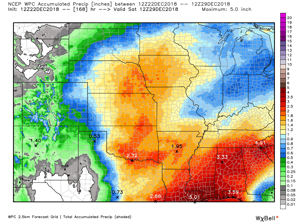
Here is the WPC/NOAA rainfall outlook.
Click to enlarge graphics on the blog.
A few showers are possible Sunday into Tuesday. Precip totals would be light.
Widespread showers and thunderstorms will impact the region Wednesday night into Friday morning.
I am forecasting a widespread 0.40″ to 0.80″ rain event. Locally higher totals likely where thunderstorms occur.

We offer interactive local city live radars and regional radars.
If a radar does not update then try another one. If a radar does not appear to be refreshing then hit Ctrl F5 on your keyboard.
You may also try restarting your browser. The local city view radars also have clickable warnings.
During the winter months, you can track snow and ice by clicking the winterize button on the local city view interactive radars.

Questions? Broken links? Other questions?
You may email me at beaudodson@usawx.com

The National Weather Service defines a severe thunderstorm as one that produces quarter size hail or larger, 58 mph winds or greater, and/or a tornado.
Today through next Wednesday: No severe weather concerns.
Next Wednesday night through next Friday: Thunderstorms are possible late Wednesday night and more likely Thursday and Thursday night. The risk of severe weather locally appears small but not zero. Monitor updates.
Interactive live weather radar page. Choose the city nearest your location. If one of the cities does not work then try a nearby one. Click here.
National map of weather watches and warnings. Click here.
Storm Prediction Center. Click here.
Weather Prediction Center. Click here.

Live lightning data: Click here.

Interactive GOES R satellite. Track clouds. Click here.

Here are the latest local river stage forecast numbers Click Here.
Here are the latest lake stage forecast numbers for Kentucky Lake and Lake Barkley Click Here.

- Holiday updates
- Widespread rain event mid to late week
- Tracking colder air in January
Good day, everyone. The updates will be short today through Christmas.
I did update the daily details above.
No major weather concerns through Wednesday. A couple of fast moving weak systems will pass through the region tonight and Sunday and again Monday night and Tuesday. These could trigger a couple of showers and/or snow/rain showers. It will be too mild for accumulating snow. Novelty flakes in the air (if it occurs at all).
The big weather story will be a large winter storm that will take aim at the central United States Wednesday night into Friday. Our region will solidly be in the warm sector. That means showers and thunderstorms.
Some locally moderate rain appears likely. Gusty winds, as well.
Blizzard conditions are possible in Nebraska, the Dakota’s, and Minnesota. We will avoid the snow.
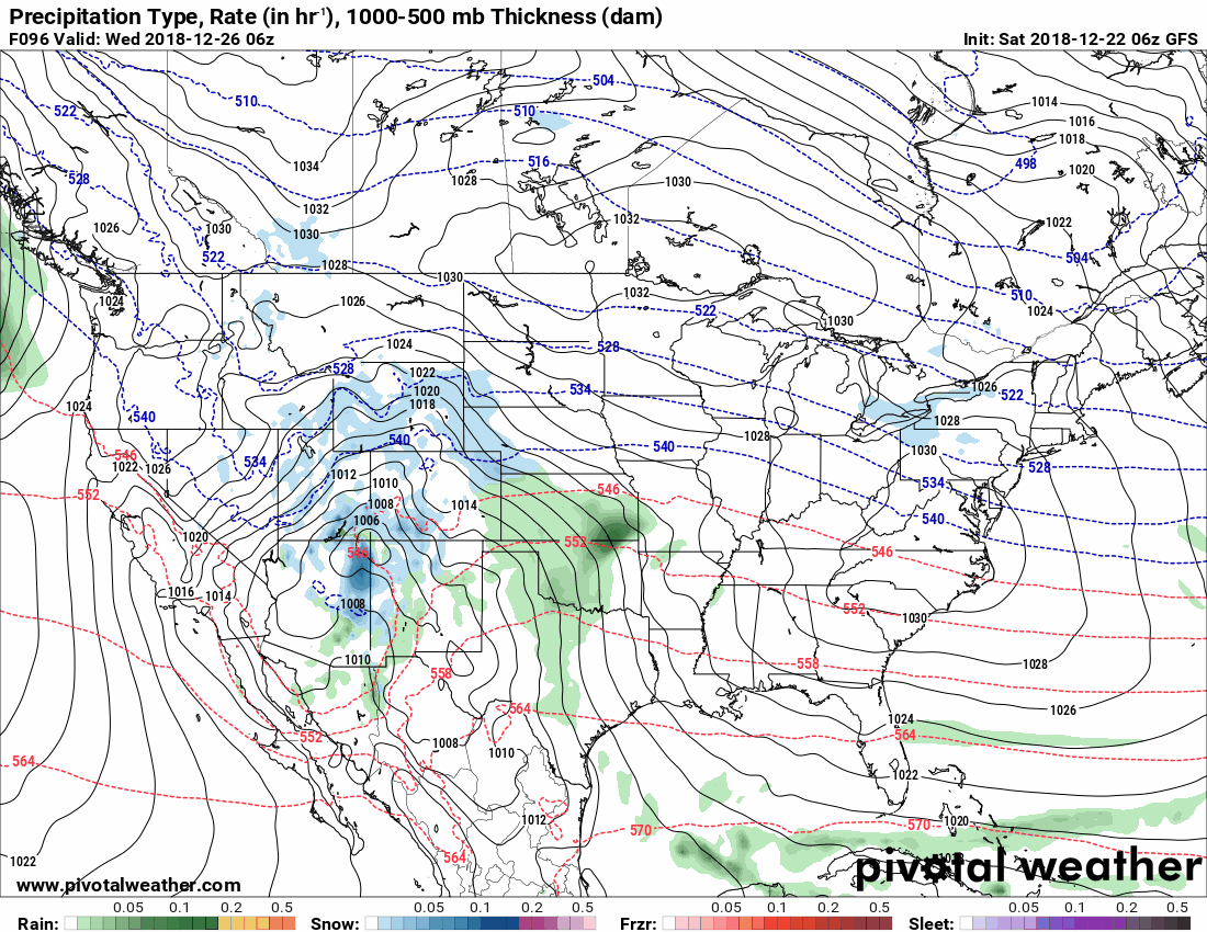
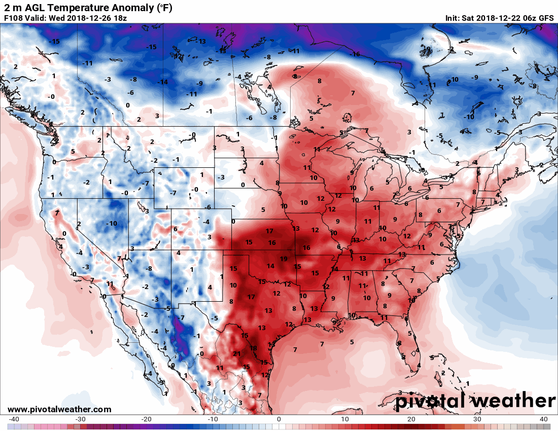
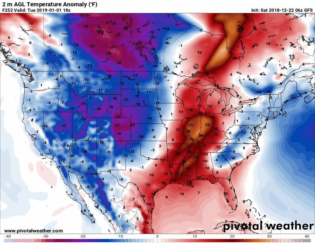
Here is that system on the GFS model guidance.
Most of the rain occurs on Thursday.
Green is rain. Dark green and yellow are moderate rain. Blue is snow.
Much above normal temperatures will accompany the storm system. We are on the warm side. Plenty of mild and moist air will be pulled northward.
Here is the temperature anomaly animation. You can see temperatures will be well above normal Wednesday into Friday. Deep red and orange/brown colors represent well above normal temperatures.
I am tracking a possible arctic outbreak of cold air (also called the polar vortex). Nothing unusual about the polar vortex. It has been around forever. It has delivered cold weather to our region forever. Somewhere along the line, the words arctic outbreak became polar vortex. Catchphrases, I supposed.
Either way, we may be looking at colder weather as we move into January. Some of the models are showing a dump of cold air around the first and second week of the month. We will see how it trends. I am not a huge fan of long-range forecast, as you know.
The problem is that this is in lala land for models. The long range. The end of the GFS run. Confidence is low.
GFS also has a cold bias. There are other favorable signals for colder air during the first week or two of January.
I am watching it.
Did you know that you can find me on Twitter?

![]()

A new weather podcast is now available! Weather Geeks (which you might remember is on The Weather Channel each Sunday)
To learn more visit their website. Click here.
![]()

WeatherBrains Episode 674
Tonight’s Guest Panelist is a meteorologist recently retired as MIC from the NWS Birmingham. Jim Stefkovitch, welcome to the show!
Our second Guest Panelist is the MIC of the NWS in Atlanta. Keith Stellman, welcome to the show!
Tonight’s Guest WeatherBrain is a Professional of Sociology at Northwestern University. His PhD is from Harvard, and he has received numerous fellowships. In fact, he is probably the smartest person we have ever had on the show. Dr. Gary Alan Fine, welcome to WeatherBrains.
Other discussions in this weekly podcast include topics like:
- TV meteorologist tragically lost to suicide
- The role of politics in the day-to-day operations of the NWS
- Upcoming 5th anniversary of “Snowmageddon”
- Astronomy Outlook with Tony Rice
- and more!
Link to their website https://weatherbrains.com/
Previous episodes can be viewed by clicking here.
We offer interactive local city live radars and regional radars. If a radar does not update then try another one. If a radar does not appear to be refreshing then hit Ctrl F5. You may also try restarting your browser.
The local city view radars also have clickable warnings.
During the winter months, you can track snow and ice by clicking the winterize button on the local city view interactive radars.
You may email me at beaudodson@usawx.com
Find me on Facebook!

Find me on Twitter!

Did you know that a portion of your monthly subscription helps support local charity projects?
You can learn more about those projects by visiting the Shadow Angel Foundation website and the Beau Dodson News website.

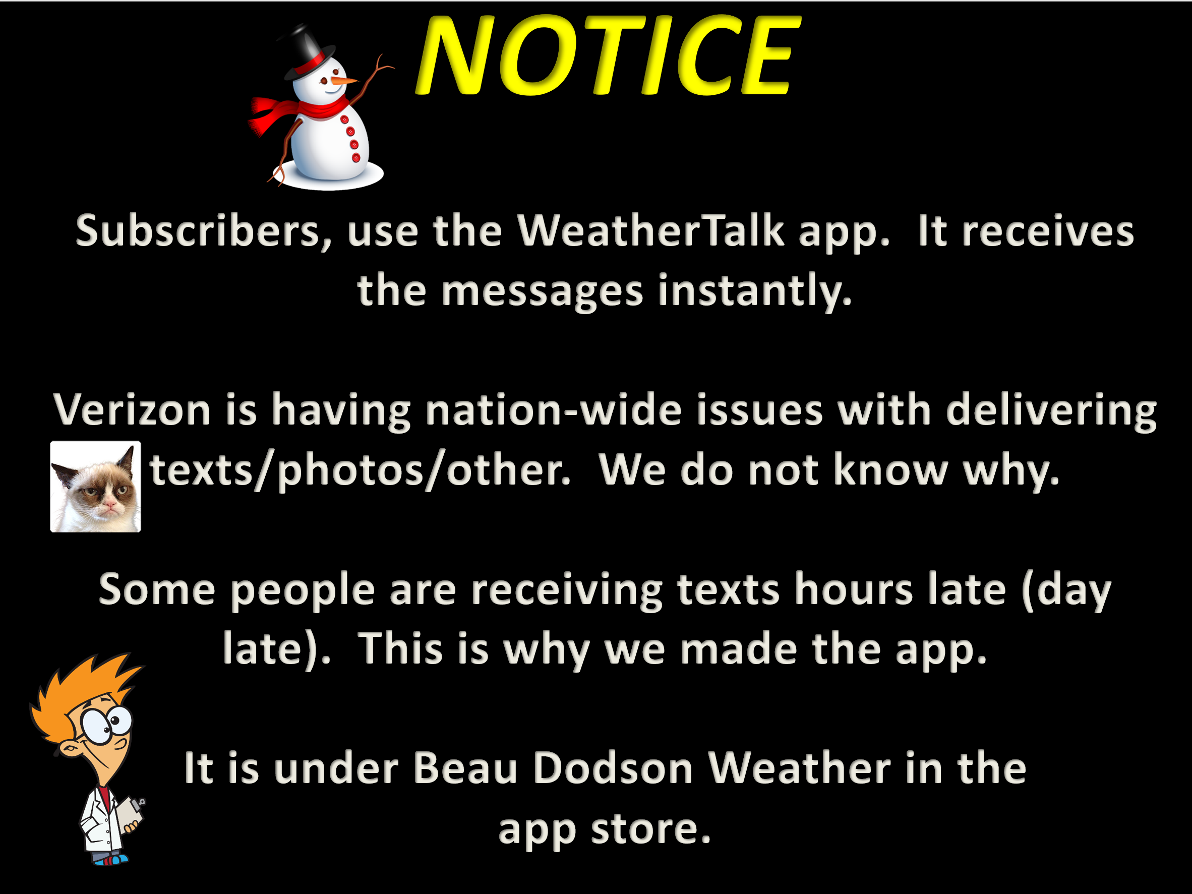
I encourage subscribers to use the app vs regular text messaging. We have found text messaging to be delayed during severe weather. The app typically will receive the messages instantly. I recommend people have three to four methods of receiving their severe weather information.
Remember, my app and text alerts are hand typed and not computer generated. You are being given personal attention during significant weather events.
