What you need to know.
.
Key Points
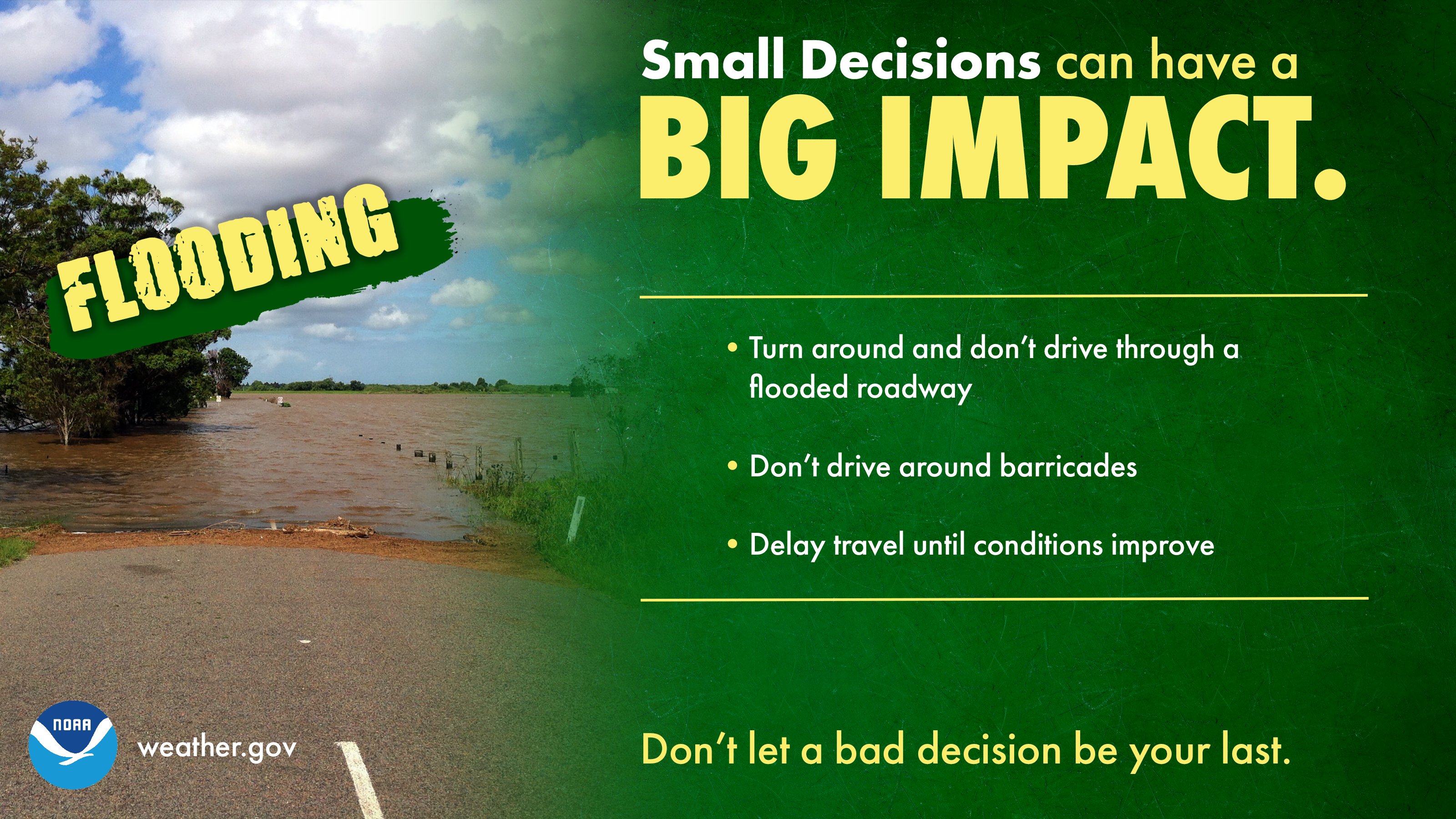
- Locally heavy rain has caused the NWS to issue some flash flood warnings and advisories. Avoid flooded roadways.
- There is a chance that some thunderstorms become severe this afternoon and evening. Damaging wind and tornadoes are the main concern. Heavy rain, of course.
- The threat is higher from the Missouri Bootheel and then eastward along the Kentucky/Tennessee border counties. From there southward.
- The threat is lower over the northern three-quarters of southeast Missouri, southern Illinois, and northwest Kentucky. Those areas should monitor.
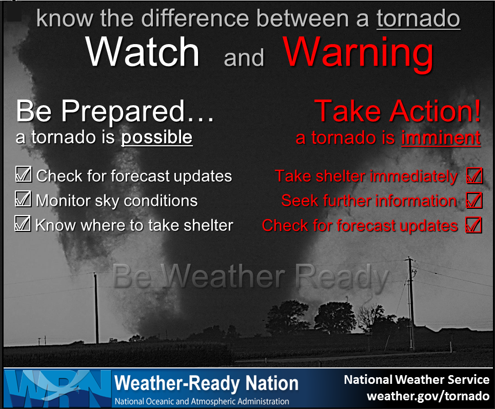
- Remember, a watch means to monitor updates. A warning means to seek shelter. A warning is a higher threat.
.
Call to action.
Monitor updated weather forecasts.
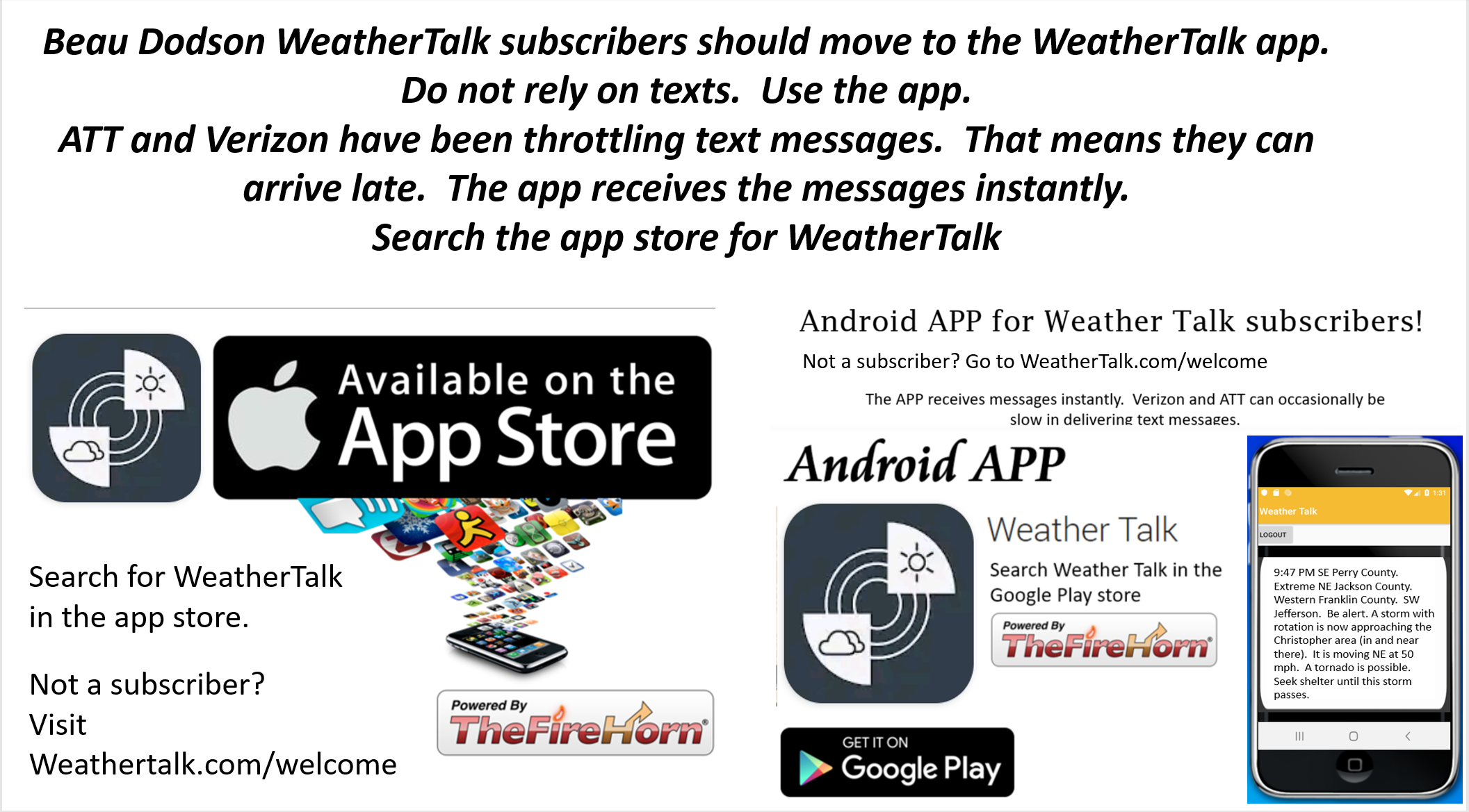
Make sure you are using the Weather Talk app. Download it from the app store. It is under Weather Talk.
TURN ON YOUR BEAU DODSON WEATHER TALK APP. Make sure it is on. Make sure you have not accidentally logged out of the app.
The app is for subscribers (please log into your account and make sure your payment has been updated. We have a large number of declined cards and PayPal payments.
Subscribe at www.weathertalk.com/welcome then go to your app store and search for WeatherTalk. Apple users click here. Android users click here
.
February 28, 2021
Scroll down to read more information on today’s severe weather concerns.
.
6:40 PM
The tornado watch has been cancelled.
.
6:30 PM
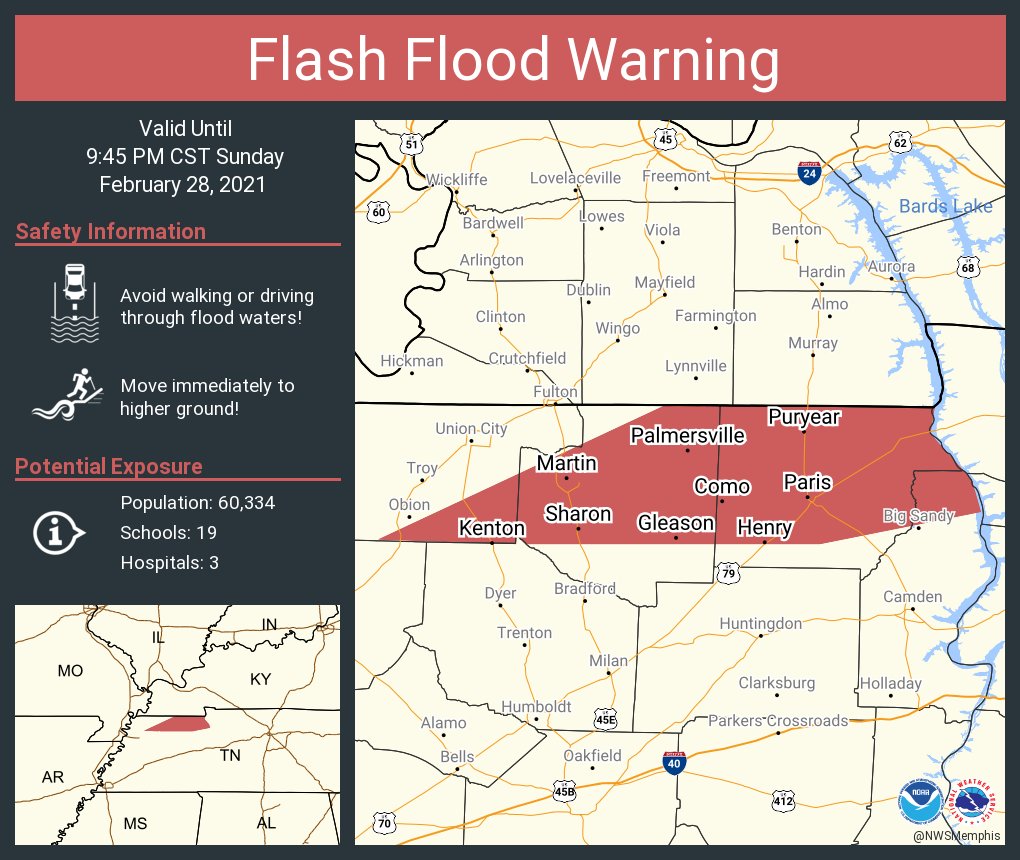
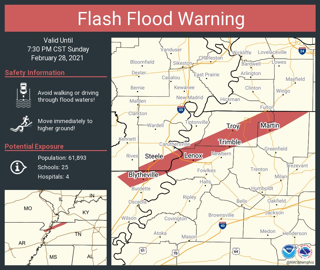
BULLETIN - EAS ACTIVATION REQUESTED
FLASH FLOOD WARNING
NATIONAL WEATHER SERVICE MEMPHIS TN
635 PM CST SUN FEB 28 2021

THE NATIONAL WEATHER SERVICE IN MEMPHIS HAS ISSUED A

* FLASH FLOOD WARNING FOR...
  NORTHEASTERN BENTON COUNTY IN WESTERN TENNESSEE...
  HENRY COUNTY IN WESTERN TENNESSEE...
  SOUTHEASTERN OBION COUNTY IN WESTERN TENNESSEE...
  WEAKLEY COUNTY IN WESTERN TENNESSEE...
.
5:15 PM
The threat of severe weather has ended.
Flash flooding will continue.
Avoid flooded roadways, please.
.
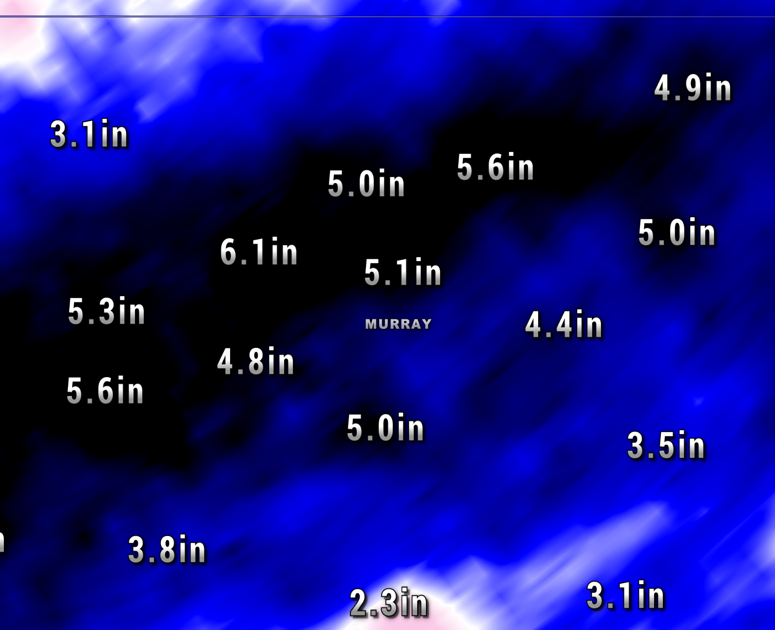
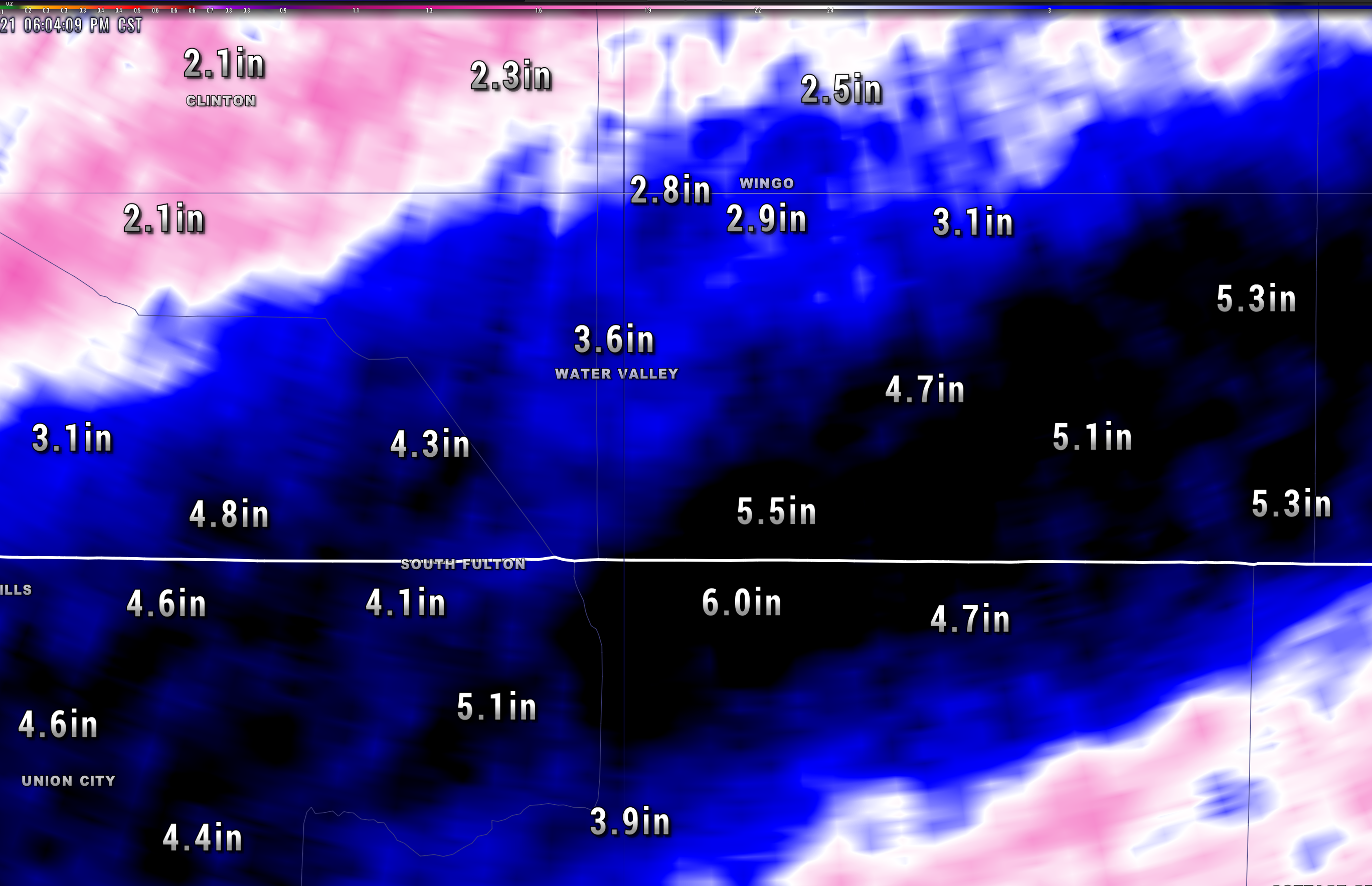
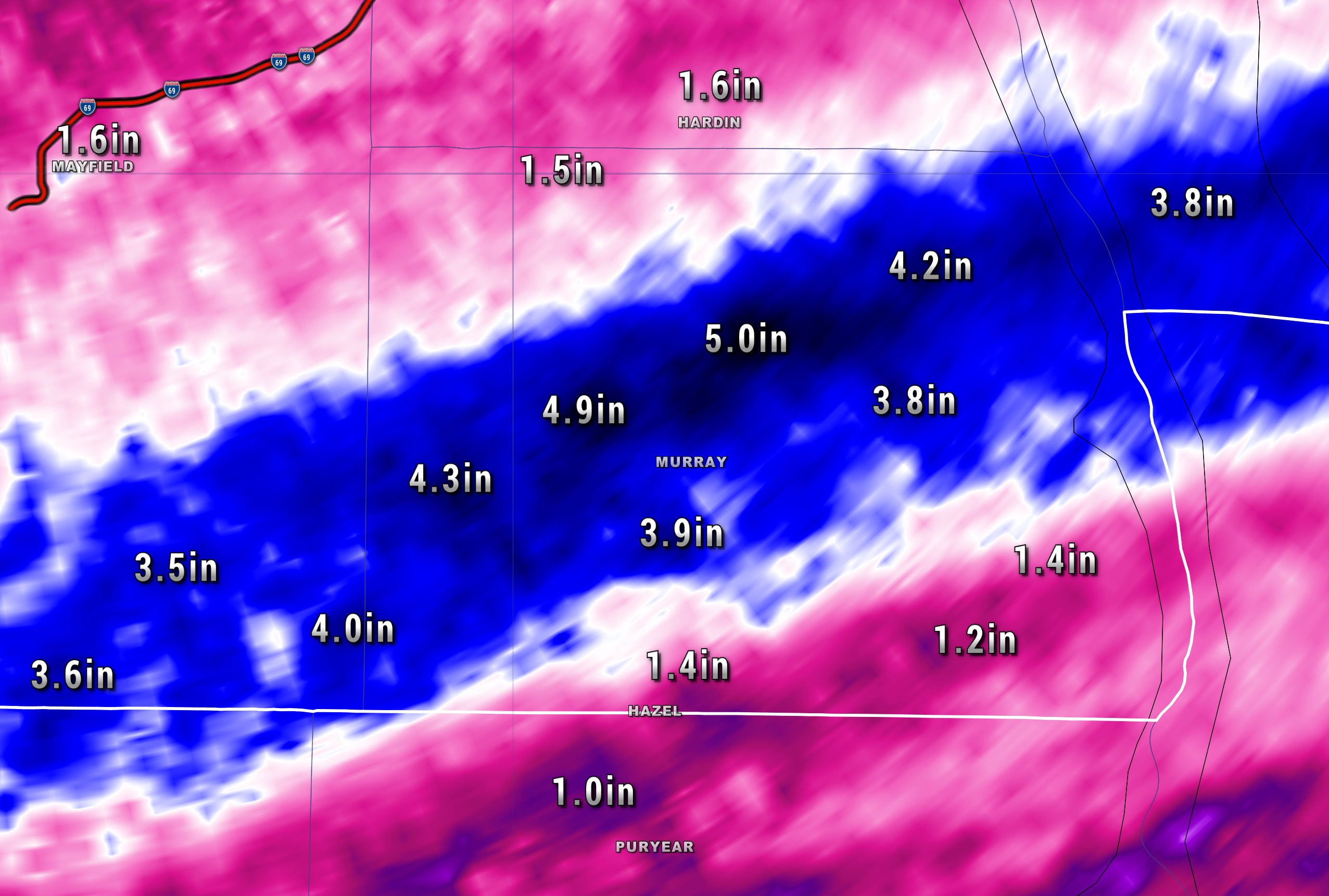
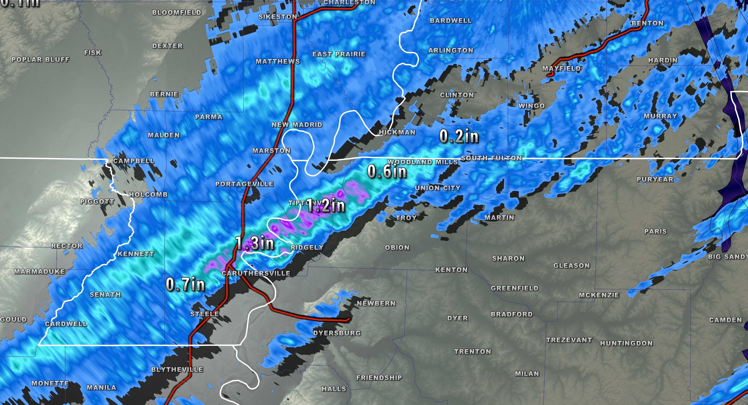
6:00 PM
Some locations have received one to two months worth of rain in less than 24-hours.
Check out these radar estimated totals.
Click on the images to enlarge them.

.
.
.
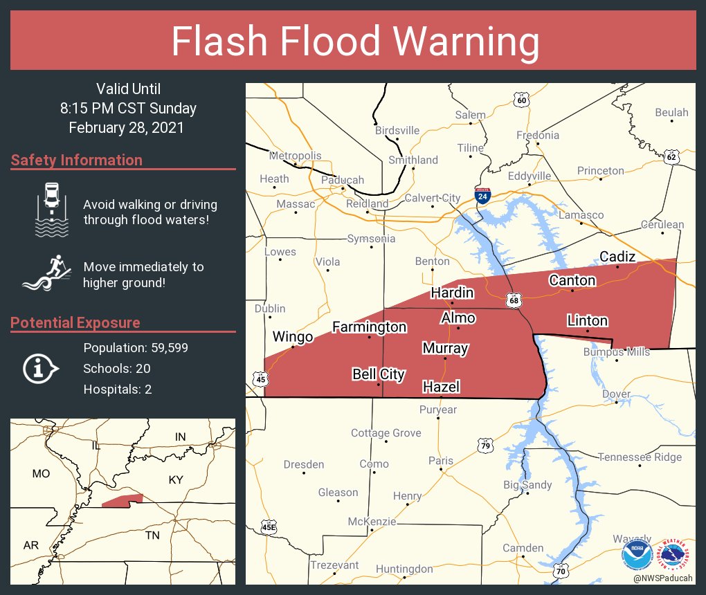
5:45 PM
.
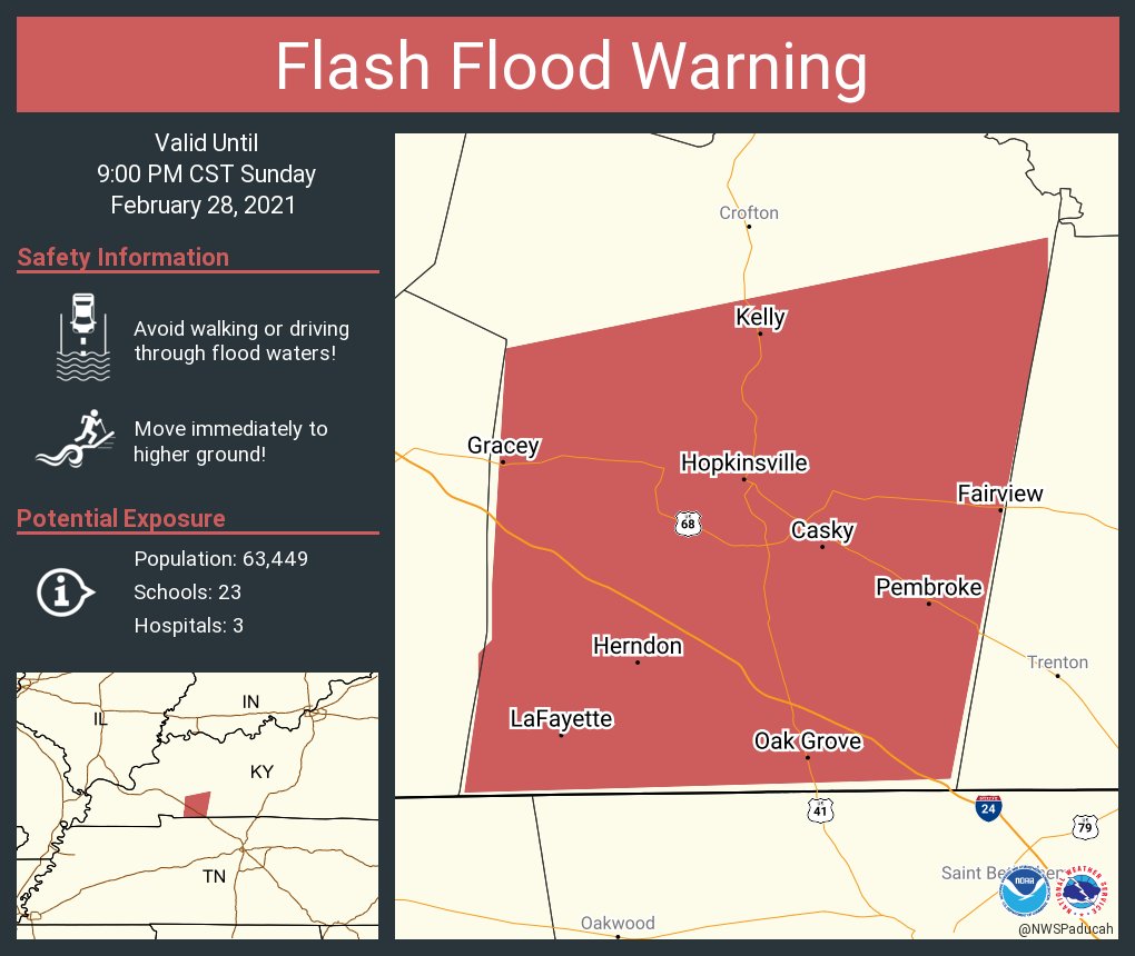
5:30 PM
FLASH FLOOD WARNING REMAINS IN EFFECT UNTIL 9 PM CST THIS EVENING
FOR CHRISTIAN COUNTY...

AT 527 PM CST, EMERGENCY MANAGEMENT REPORTED MANY ROADS FLOODED
ACROSS THE WARNED AREA. BETWEEN 3 AND 6 INCHES OF RAIN HAVE FALLEN.
FLASH FLOODING IS ALREADY OCCURRING.
.
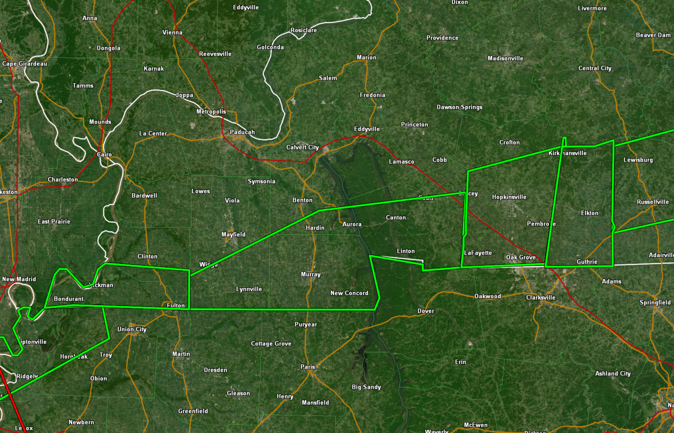
5:17 PM
Very heavy rain is falling across portions of western Kentucky.
During the past hour, radar estimates this is how much has fallen.

Check out the totals near Murray. This is what fell last night and this morning.
.
5:10 PM
.
5:00 PM
.
FLASH FLOOD WARNING
NATIONAL WEATHER SERVICE MEMPHIS TN
444 PM CST SUN FEB 28 2021

THE NATIONAL WEATHER SERVICE IN MEMPHIS HAS ISSUED A

* FLASH FLOOD WARNING FOR...
  SOUTHEASTERN LAKE COUNTY IN WESTERN TENNESSEE...
  NORTHWESTERN OBION COUNTY IN WESTERN TENNESSEE...

* UNTIL 745 PM CST.

* AT 444 PM CST, DOPPLER RADAR INDICATED THUNDERSTORMS PRODUCING
  HEAVY RAIN ACROSS THE WARNED AREA. BETWEEN 2 AND 3 INCHES OF RAIN
  HAVE FALLEN. FLASH FLOODING IS ONGOING OR EXPECTED TO BEGIN
  SHORTLY.

  HAZARD...FLASH FLOODING CAUSED BY THUNDERSTORMS.
.
FLASH FLOOD STATEMENT
NATIONAL WEATHER SERVICE PADUCAH KY
457 PM CST SUN FEB 28 2021

KYC035-083-157-221-010215-
/O.CON.KPAH.FF.W.0003.000000T0000Z-210301T0215Z/
/00000.0.ER.000000T0000Z.000000T0000Z.000000T0000Z.OO/
CALLOWAY KY-GRAVES KY-MARSHALL KY-TRIGG KY-
457 PM CST SUN FEB 28 2021

...FLASH FLOOD WARNING REMAINS IN EFFECT UNTIL 815 PM CST THIS
EVENING FOR CALLOWAY, SOUTHERN GRAVES, SOUTHEASTERN MARSHALL AND
TRIGG COUNTIES...

AT 457 PM CST, DOPPLER RADAR AND AUTOMATED RAIN GAUGES INDICATED
THUNDERSTORMS CONTINUE TO PRODUCE VERY HEAVY RAIN ACROSS THE WARNED
AREA. ADDITIONAL SIGNIFICANT FLOODING IS IMMINENT ACROSS SOUTHERN
GRAVES INTO CALLOWAY COUNTIES.
.
4:55 PM
The risk of severe weather is diminishing. The risk of flash flooding remains high.
Clouds and ongoing heavy rain are keeping instability in check. This is lowering the risk of tornadoes. There is still a low-end risk that a storm may produce damaging wind.
The bigger concern continues to be widespread heavy rain. Many locations are experiencing flash flooding and this will continue into the evening.
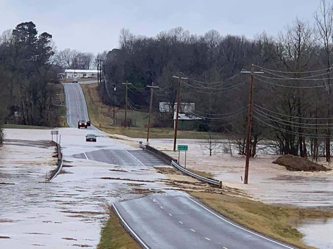
Avoid flooded roadways. Multiple roads were washed out in the region today. Some culverts were washed away. You could drive into water, thinking that the road is still there, but it may not be. Turn around and find an alternative route.
The rain will end west to east overnight.
.
4:41 PM
FLASH FLOOD WARNING
NATIONAL WEATHER SERVICE MEMPHIS TN
437 PM CST SUN FEB 28 2021

THE NATIONAL WEATHER SERVICE IN MEMPHIS HAS ISSUED A

* FLASH FLOOD WARNING FOR...
  NORTH CENTRAL MISSISSIPPI COUNTY IN EASTERN ARKANSAS...
  SOUTHERN PEMISCOT COUNTY IN SOUTHEASTERN MISSOURI...
  NORTHWESTERN DYER COUNTY IN WESTERN TENNESSEE...
  SOUTH CENTRAL LAKE COUNTY IN WESTERN TENNESSEE...
  CENTRAL OBION COUNTY IN WESTERN TENNESSEE...
  NORTHERN WEAKLEY COUNTY IN WESTERN TENNESSEE...

* UNTIL 730 PM CST.

* AT 437 PM CST, DOPPLER RADAR INDICATED THUNDERSTORMS PRODUCING
  HEAVY RAIN ACROSS THE WARNED AREA. BETWEEN 2 AND 3 INCHES OF RAIN
  HAVE FALLEN. FLASH FLOODING IS ONGOING OR EXPECTED TO BEGIN
  SHORTLY.
.
4:15 PM
Flash flood remains the big concern this evening.
.
4:00 PM
Flash flood update
https://www.wpc.ncep.noaa.gov/metwatch/metwatch_mpd_multi.php?md=34&yr=2021

.
3:56 PM
Radar indicated one hour rain totals coming out of NW TN.
Moving into western KY.
This is going to cause more problems with flooding.
.
3:45 PM
Flash flood warnings cover several western Kentucky counties.
Avoid flooded roadways.
.
3:41 PM

BULLETIN - EAS ACTIVATION REQUESTED
FLASH FLOOD WARNING
NATIONAL WEATHER SERVICE MEMPHIS TN
337 PM CST SUN FEB 28 2021

THE NATIONAL WEATHER SERVICE IN MEMPHIS HAS ISSUED A

* FLASH FLOOD WARNING FOR...
  NORTH CENTRAL MISSISSIPPI COUNTY IN EASTERN ARKANSAS...
  SOUTHEASTERN DUNKLIN COUNTY IN SOUTHEASTERN MISSOURI...
  PEMISCOT COUNTY IN SOUTHEASTERN MISSOURI...
  LAKE COUNTY IN WESTERN TENNESSEE...
  NORTHWESTERN OBION COUNTY IN WESTERN TENNESSEE...

* UNTIL 600 PM CST.

* AT 337 PM CST, DOPPLER RADAR INDICATED THUNDERSTORMS PRODUCING
  HEAVY RAIN ACROSS THE WARNED AREA. FLASH FLOODING IS ONGOING OR
  EXPECTED TO BEGIN SHORTLY.

  HAZARD...FLASH FLOODING CAUSED BY THUNDERSTORMS.

  SOURCE...DOPPLER RADAR.

  IMPACT...FLOODING OF SMALL CREEKS AND STREAMS, URBAN AREAS,
           HIGHWAYS, STREETS AND UNDERPASSES AS WELL AS OTHER
           DRAINAGE AND LOW LYING AREAS.
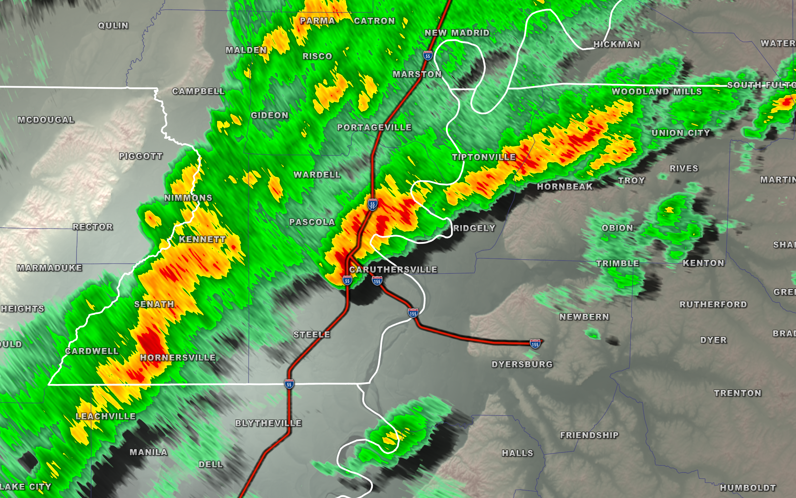
3:39 PM
Storms continue to move through the Missouri Bootheel and into northwest Tennessee.
Some of these storms may produce damaging wind and even a tornado.
Seek shelter until the storms have moved past your area.
See the local radars to track the storms
Radars with clickable watches and warnings.
https://wtalk.co/B3XHASFZ
Backup radar site in case the above one is not working.
https://weathertalk.com/morani
.
Some photos from today
.
Dangerous life-threatening flooding occurring in Elkton, KY. https://t.co/NhB6hFaWB9
— NWS Paducah, KY (@NWSPaducah) February 28, 2021
.
TN/KY border flooding this morning in Fulton and South Fulton per Joni Yates. #tnwx #kywx #pahspotter #flood pic.twitter.com/REAiAgcnKj
— Jennifer ☈ ukavina (@RukavinaBidwell) February 28, 2021
.
Numerous roads with water over them in Pembroke KY and surrounding areas of Christian County. #TurnAroundDontDrown https://t.co/Pemaam4b74
— NWS Paducah, KY (@NWSPaducah) February 28, 2021
.
Tress Shop Rd/KY 475 in Todd County impassable due to flash flooding in the 1300 block. Photo from Perry Knight. @NWSPaducah pic.twitter.com/O9w42MvOfQ
— WHOP AM/FM (@WHOPradio) February 28, 2021
.
Major flooding reported in Murray on North 16th.
Serious flooding has been reported across much of Calloway county.
📸: Max Parrish @NWSPaducah #kywx pic.twitter.com/ugAPJ90GIF
— Noah Bergren (@NbergWX) February 28, 2021
.
Todd County Sheriff’s Sgt. Patrick Turner reports high water over many roads, even ones that do not normally flood. He advises motorists to use extreme caution if they must get out and to never try to drive through standing water. @NWSPaducah pic.twitter.com/IFXhzadopl
— WHOP AM/FM (@WHOPradio) February 28, 2021
.
A van became disabled in Hopkinsville on East 9th Street near the railroad tracks. Flooding is occurring across the southern Pennyrile region. #kywx pic.twitter.com/S603YlkgN2
— Joshua Claussen (@StormyClaussen) February 28, 2021
Murray, KY residential area and backyard of friend Chelsea Tucker who lives near Bee Creek and Bailey Road. Rainfall over 3-4” this morning with more on the way. #pahspotter #kywx #flooding #flashflood @NWSPaducah @JimCantore @MeanMotionMedia @weatherchannel pic.twitter.com/dKjeFibF6q
— Jennifer ☈ ukavina (@RukavinaBidwell) February 28, 2021
3:18 PM
Dunklin, Pemiscot, and Lake County.
Radar shows an area of rotation near Hollywood and Hornersville in Dunklin County moving into Pemiscot County, MO. The storm is moving E NE at 45 mph.
Damaging wind will be possible with these thunderstorms.
Seek shelter until this storm passes.
Radars with clickable watches and warnings.
https://wtalk.co/B3XHASFZ
Backup radar site in case the above one is not working.
https://weathertalk.com/morani
.
2:55 PM
NATIONAL WEATHER SERVICE PADUCAH KY
250 PM CST SUN FEB 28 2021

FLASH FLOOD EMERGENCY FOR CENTRAL TODD COUNTY...INCLUDING
ELKTON

THE NATIONAL WEATHER SERVICE IN PADUCAH HAS ISSUED A

* FLASH FLOOD WARNING FOR...
  TODD COUNTY IN SOUTH CENTRAL KENTUCKY...

* UNTIL 900 PM CST SUNDAY.

* AT 250 PM CST, EMERGENCY MANAGEMENT REPORTED EVACUATION OF SEVERAL
  HOMES IN ELKTON. WIDESPREAD FLASH FLOODING OF SMALL STREAMS ACROSS
  BOTH RURAL AND URBAN AREAS IS OCCURRING. BETWEEN 4 AND 6 INCHES OF
  RAIN HAVE FALLEN. ADDITIONAL ROUNDS OF HEAVY RAIN ARE EXPECTED TO
  MOVE THROUGH TODD COUNTY THROUGH EARLY THIS EVENING, WHICH WILL
  ONLY MAKE THE ONGOING FLOODING SITUATION WORSE.

  THIS IS A FLASH FLOOD EMERGENCY FOR CENTRAL TODD COUNTY...
  INCLUDING ELKTON. THIS IS A PARTICULARLY DANGEROUS SITUATION. SEEK
  HIGHER GROUND NOW!
.
2:53 PM
Dunklin and Pemiscot Counties. Lake County, TN.
Radar shows a new storm with rotation west of Steele, MO. That would be SE Dunklin County entering Pemiscot County. There has been rotation with this storm.
Be alert as these storms move through your area.
Radars with clickable watches and warnings.
https://wtalk.co/B3XHASFZ
Backup radar site in case the above one is not working.
https://weathertalk.com/morani
.
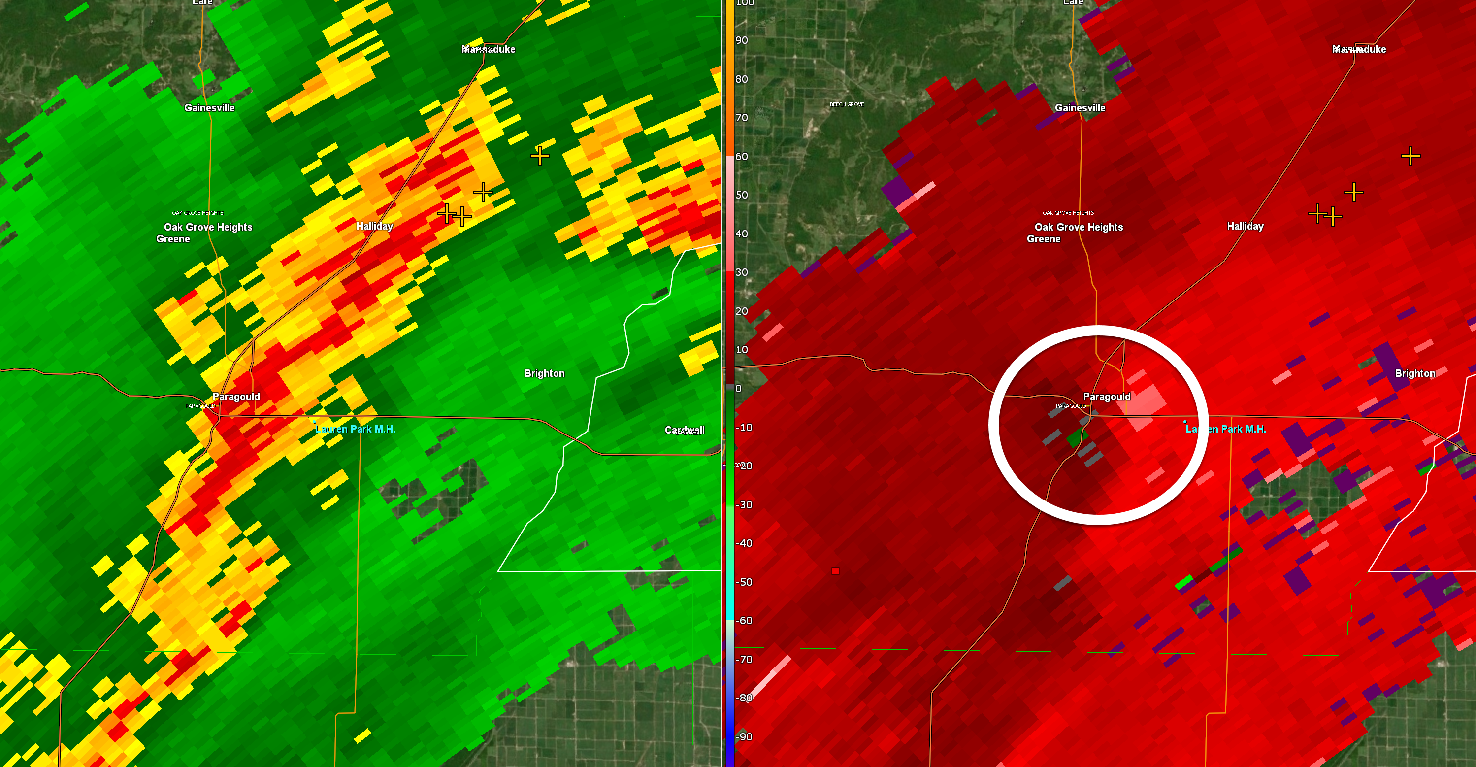
2:38 PM
Dunklin and Pemiscot Counties.
An area of rotation was noted on radar near Paragould, AR. This storm is moving E NE at 45 mph.
Be alert as these storms move into the Bootheel.
Radars with clickable watches and warnings.
https://wtalk.co/B3XHASFZ
Backup radar site in case the above one is not working.
https://weathertalk.com/morani
.
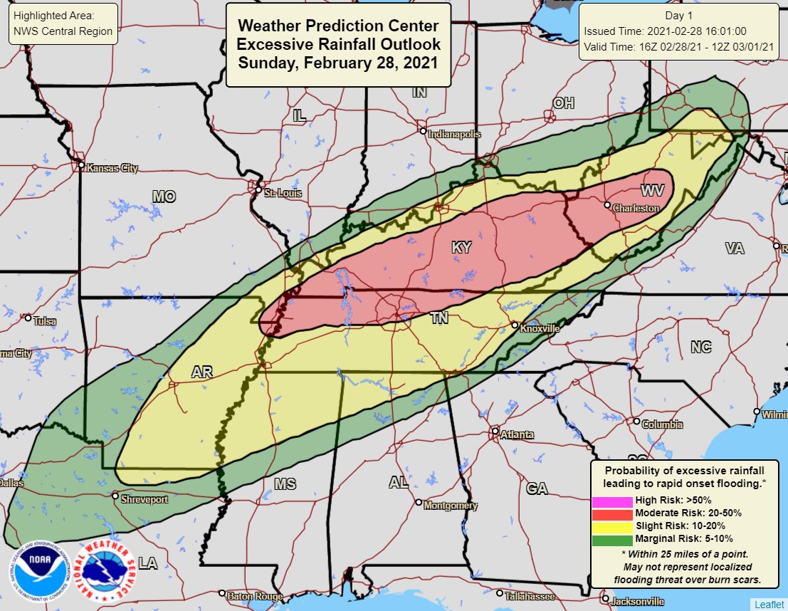
2:25 PM
Tornado watch
Click to enlarge


.
2:21 PM
BULLETIN - EAS ACTIVATION REQUESTED
FLASH FLOOD WARNING
NATIONAL WEATHER SERVICE PADUCAH KY
210 PM CST SUN FEB 28 2021

THE NATIONAL WEATHER SERVICE IN PADUCAH HAS ISSUED A

* FLASH FLOOD WARNING FOR...
  FULTON COUNTY IN WESTERN KENTUCKY...
  SOUTHERN HICKMAN COUNTY IN WESTERN KENTUCKY...

* UNTIL 815 PM CST SUNDAY.

* AT 210 PM CST, DOPPLER RADAR INDICATED THUNDERSTORMS PRODUCING
  HEAVY RAIN ACROSS THE WARNED AREA. THIS AREA RECEIVED CONSIDERABLE
  HEAVY RAINFALL THIS MORNING, AND THIS ADDITIONAL RAIN WILL CAUSE
  FLASH FLOODING TO DEVELOP QUICKLY.

  HAZARD...FLASH FLOODING CAUSED BY THUNDERSTORMS.

  SOURCE...DOPPLER RADAR.

  IMPACT...FLOODING OF SMALL CREEKS AND STREAMS, URBAN AREAS,
           HIGHWAYS, STREETS AND UNDERPASSES AS WELL AS OTHER
           DRAINAGE AND LOW LYING AREAS.
1:00 PM
A severe thunderstorm or tornado watch is likely going to be issued for portions of the area.
.
12:45 PM
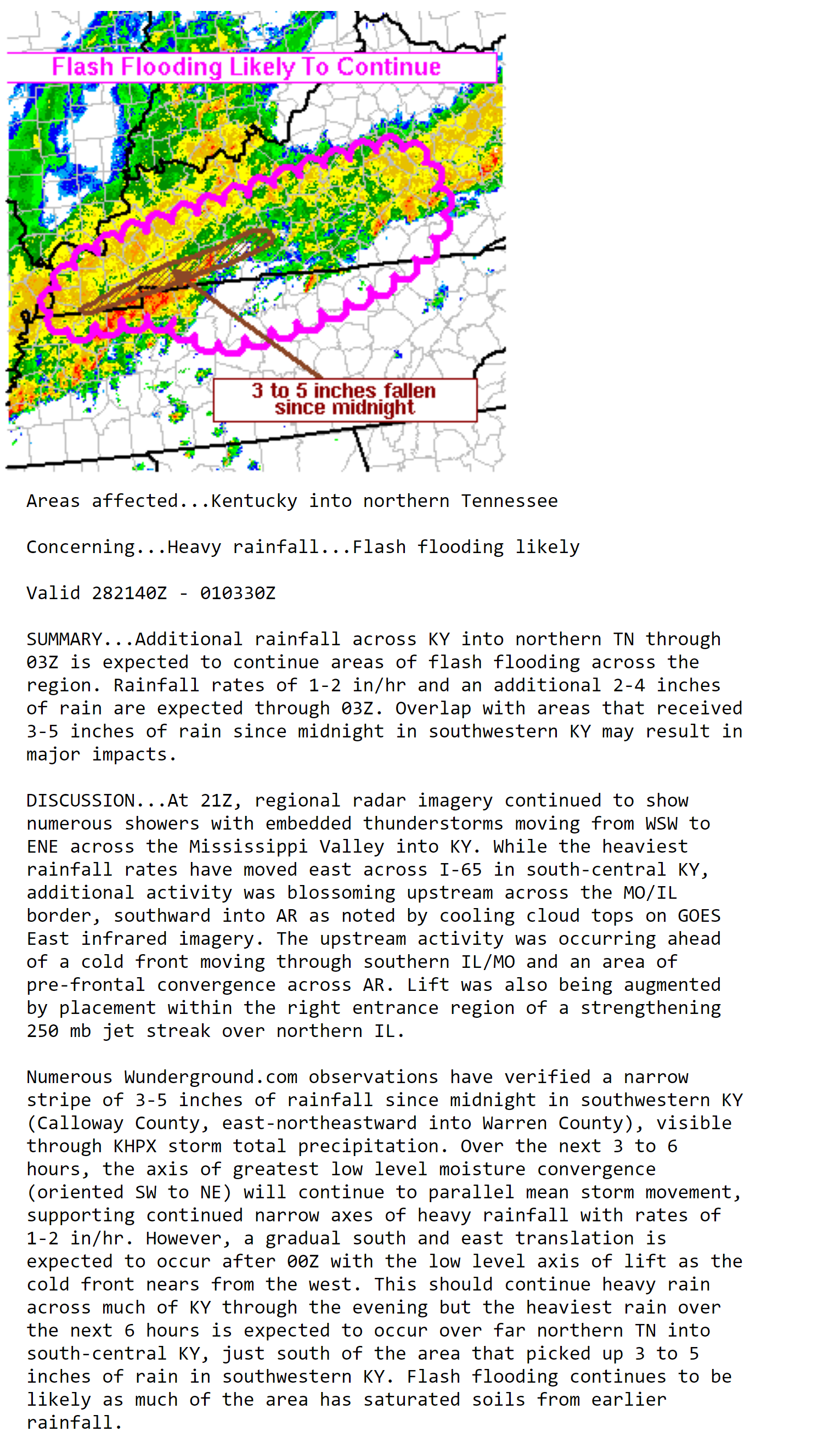
Discussion concerning heavy rain.


10:40 AM
Severe thunderstorms are possible later this afternoon and evening. Mainly across far southeast Missouri, western Kentucky, and western Tennessee.
Areas further north should monitor, as well.
Scroll down for more graphics.
.
10:40 AM
Opportunity Church in Murray, Kentucky, has been flooded. Unsure who took these photographs.
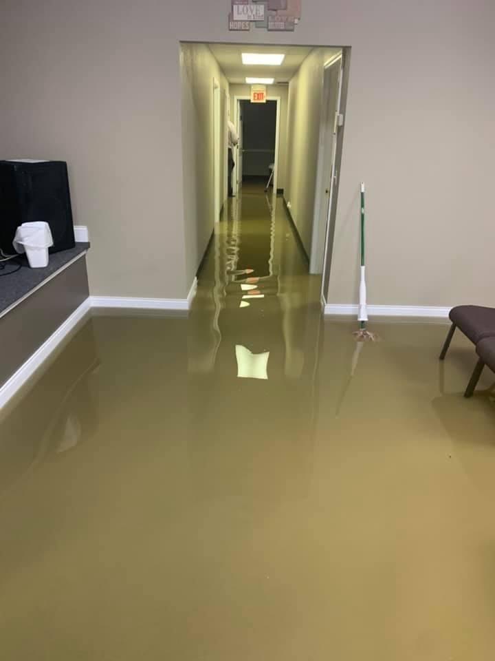

.
Unsure who took this photograph but you should not drive through this kind of water. It is dangerous.
.
10:30 AM
I am watching for the formation of a line of storms this afternoon.
The NAM model shows it well. Notice the placement.
Time-stamp upper left. Click to enlarge the animation.

.
9:45 AM
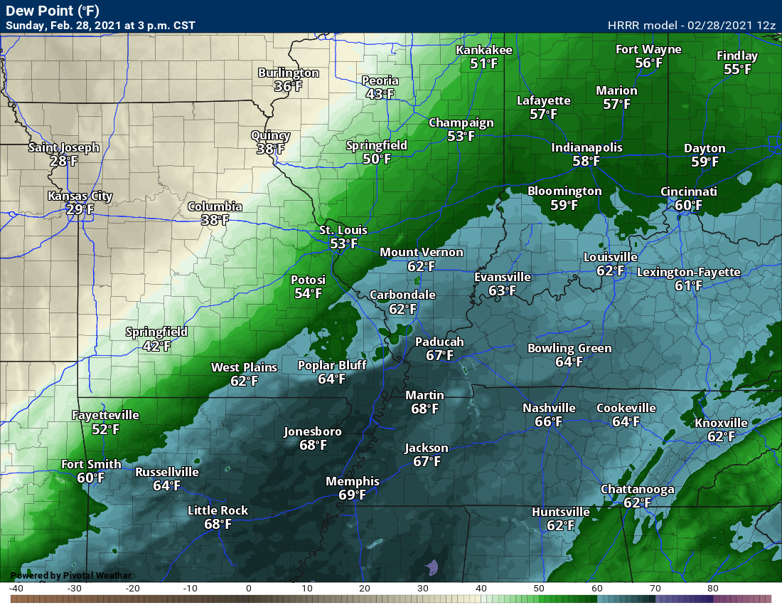
Dew points will rise today into the 60s. Humid air. The air will feel heavier across areas with mid to upper 60s.
Dew point is what makes it feel humid outside.
.
Let’s look at the Hrrr model future-cast radar. This shows you the concern later today.
Double click on the animation to enlarge it. Time-stamp upper left.

.
9:30 AM
Diana Foster sent this photo in from Murray, Kentucky. Early morning flooding.
Local Storm Report by NWS PAH: 2 SE Murray [Calloway Co, KY] mesonet reports HEAVY RAIN of M3.05 INCH at 09:00 AM CST — mesonet station murk2 1.6 se murray.
9:25 AM
Significant flash flooding has been reported across portions of southern Graves County into Calloway County. Areas east of there, as well.
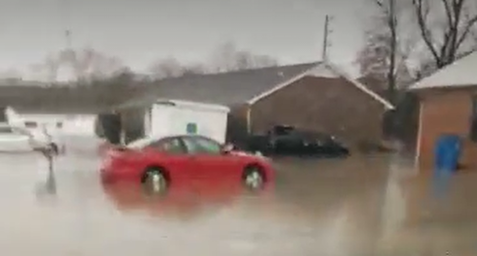
Serious flooding is ongoing in Murray, Kentucky. There have been reports of water entering homes and businesses.
There have also been numerous reports of swift water flowing over many roadways. Remember, it only takes six inches of fast flowing water to move a vehicle.
Please avoid flooded roadways. Turn around and find an alternative route. Emergency services are already busy dealing with the flooding.
The heaviest rain, for now, is about to move out of Graves and Calloway Counties. Heavy rain will continue across portions of Trigg, Christian, and Todd Counties.
Additional showers and thunderstorms are possible throughout the day. Thus, additional flooding will be possible.
.
9:17 reports. Murray, Kentucky.
Source: trained spotter
Remark: considerable flash flooding occurring the murray area. numerous roads are flooded, including us 641 and highway 80. water is entering homes and businesses.
.
 9 AM radar
.
FLASH FLOOD WARNING NATIONAL WEATHER SERVICE PADUCAH KY 823 AM CST SUN FEB 28 2021 THE NATIONAL WEATHER SERVICE IN PADUCAH HAS ISSUED A * FLASH FLOOD WARNING FOR... CALLOWAY COUNTY IN WESTERN KENTUCKY... SOUTHERN GRAVES COUNTY IN WESTERN KENTUCKY... SOUTHEASTERN MARSHALL COUNTY IN WESTERN KENTUCKY... TRIGG COUNTY IN WESTERN KENTUCKY... * UNTIL 230 PM CST SUNDAY. * AT 823 AM CST, DOPPLER RADAR INDICATED THUNDERSTORMS PRODUCING HEAVY RAIN ACROSS THE WARNED AREA. BETWEEN 1 AND 2 INCHES OF RAIN HAVE FALLEN. FLASH FLOODING IS ONGOING OR EXPECTED TO BEGIN SHORTLY.. .
FLASH FLOOD WARNING
NATIONAL WEATHER SERVICE PADUCAH KY
851 AM CST SUN FEB 28 2021

THE NATIONAL WEATHER SERVICE IN PADUCAH HAS ISSUED A

* FLASH FLOOD WARNING FOR...
  CHRISTIAN COUNTY IN SOUTH CENTRAL KENTUCKY...
  TODD COUNTY IN SOUTH CENTRAL KENTUCKY...

* UNTIL 300 PM CST SUNDAY.

* AT 851 AM CST, DOPPLER RADAR INDICATED THUNDERSTORMS PRODUCING
  HEAVY RAIN ACROSS THE WARNED AREA. FLASH FLOODING IS ONGOING OR
  EXPECTED TO BEGIN SHORTLY.

  HAZARD...FLASH FLOODING CAUSED BY THUNDERSTORMS.
.
.
I will keep the blog updated today. Scroll down to read more information.
Make sure you have downloaded the Beau Dodson Weather App. Make sure it is on. Open it and check.
The app is under WeatherTalk in the app store.

Apple users click here

Android users click here
.
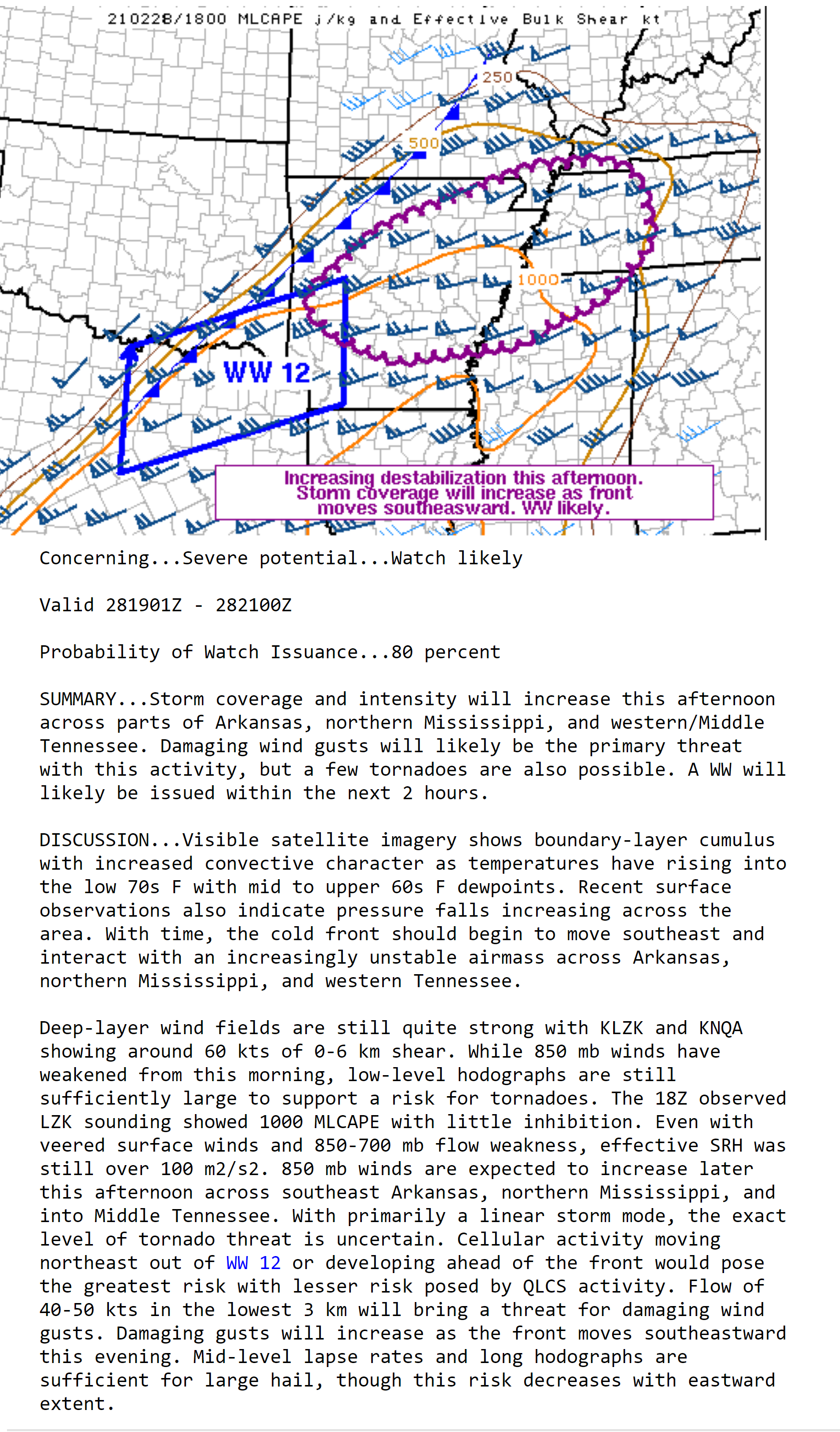
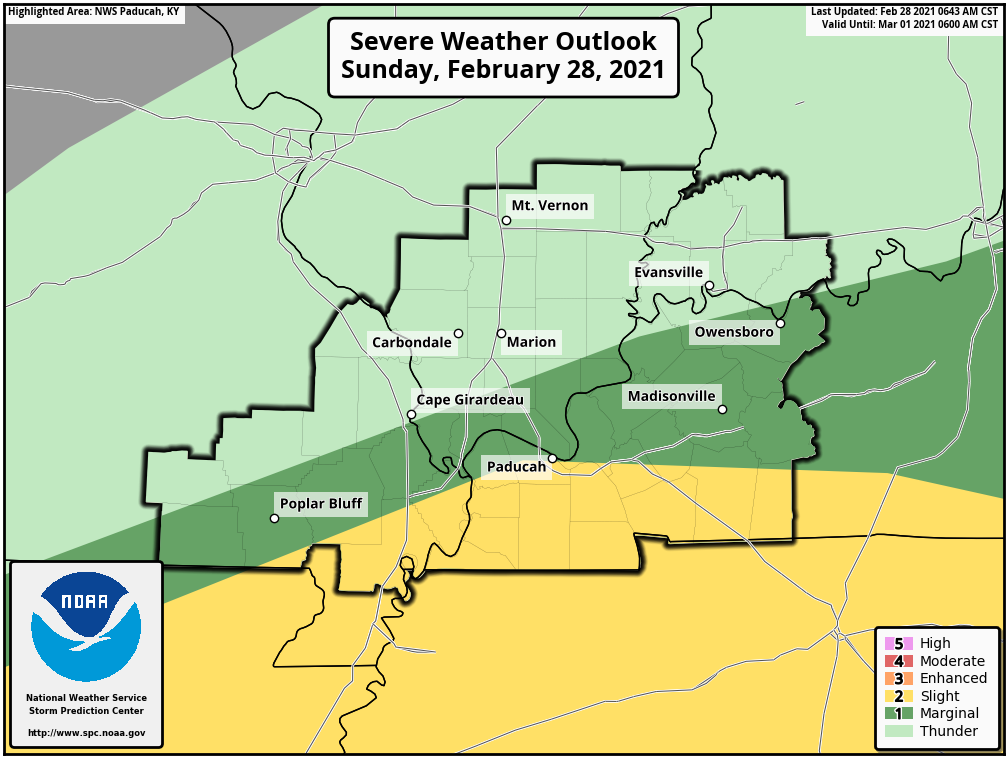
FORECAST DISCUSSION
We may have some severe thunderstorms later this afternoon. It appears the 3 PM to 8 PM time-frame is the period of concern.
A few thunderstorms could produce damaging wind gusts. There is also a risk of tornadoes.
The Storm Prediction Center has outlined portions of the region for a level one and two risk.
Two is the higher level. That would be the yellow zone.
Don’t get too got up in the exact placement of the color zones. Weather does not always follow our colors.
Take the general idea that some storms could be intense today.
The thick black zone is simply the Paducah, Kentucky, National Weather Service forecast area. Ignore that.
The light green zone is where thunderstorms are possible, but they should remain below severe levels.
The dark green and yellow zones are where a few storms may become severe.
The Storm Prediction Center will update this between 10 and 11 AM and then again between 1 and 2 PM.
.
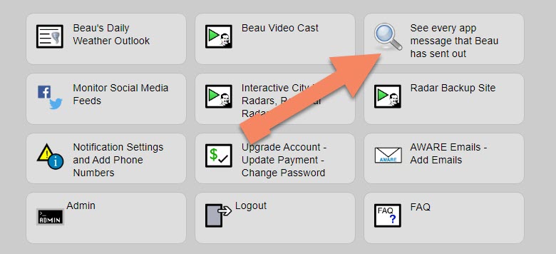
Note: We added a “see all” button on the website. This allows you to see every message that I have sent out (to all my forecast counties).
Here is the link. Click here.
To view the live radars, visit these links.
Radars
Interactive city-view radars
http://weatherobservatory.com/weather-radar.htm
A third backup radar
https://weathertalk.com/morani
Clickable watches and warnings can be viewed on the local city-view interactive radars (link above). Be sure and turn on the warnings above the local radars.
A new regional radar we offer
https://imagery.weathertalk.com/prx/RadarLoop.mp4
Lightning data
https://wtalk.co/7QT7WHKU
.
Storm Prediction Center severe weather outlook.
Here is the latest Storm Prediction Center outlook. Remember, don’t pay too much attention to the different colors. Focus on the actual forecast. The forecast is for a few severe thunderstorms.
The black outline is our local area.
Light green is where thunderstorms may occur but should be below severe levels.
Dark green is a level one risk. Yellow is a level two risk. Orange is a level three (enhanced) risk. Red is a level four (moderate) risk. Pink is a level five (high) risk.
One is the lowest risk. Five is the highest risk.
A severe storm is one that produces 58 mph wind or higher, quarter size hail, and/or a tornado.

.
Tomorrow’s severe weather outlook.

Not receiving app/text messages?
USE THE APP. ATT and Verizon are slowing or stopping the text messages.
Make sure you have the correct app/text options turned on. Find those under the personal notification settings tab at www.weathertalk.com. Red is off. Green is on.
Subscribers, PLEASE USE THE APP. ATT and Verizon are not reliable during severe weather. They are delaying text messages.
The app is under WeatherTalk in the app store.
Apple users click here
Android users click here
.

Live lightning data: Click here.