- Monthly costs to run Weather Talk can top $2000.00
Please consider subscribing!
Here are my monthly out of pocket costs to deliver you the weather.
.

.
Do you want more? How about short and long range outlooks, videos, and more detailed analysis! You will receive that with your subscription.
Subscribe at www.beaudodsonweather.com
Once subscribed you can choose from four different app/text messages!
.
.
.

.
Interactive Weather Radar Page. Choose the city nearest your location: Click this link.
January 28, 2018
Sunday Forecast Details
Forecast: Mostly sunny with a few passing clouds. A bit cooler.
Temperatures: MO ~ 53 to 56 IL ~ 50 to 55 KY ~ 52 to 55
What is the chance of precipitation? MO ~ 0% IL ~ 0% KY ~ 0% TN ~ 0%
Coverage of precipitation: None
Wind chill values: N/A
Accumulating snow or ice: No
Winds: North at 5 to 10 mph
What impacts are anticipated from the weather? None
My confidence in the forecast verifying: High
Is severe weather expected? No
The NWS defines severe weather as 58 mph wind or great, 1″ hail or larger, and/or tornadoes
Should I cancel my outdoor plans? No
.
Sunday Night Forecast Details:
Forecast: Mostly clear early. Increasing clouds overnight. Light snow showers or snow flurries possible late. No accumulation to perhaps a dusting in spots. Best chance of that would be across southern Illinois into northwest Kentucky.
Temperatures: MO ~ 26 to 32 IL ~ 26 to 32 KY ~ 26 to 32
What is the chance of precipitation? MO ~ 30% IL ~ 40% KY ~ 30% TN ~ 20%
Coverage of precipitation: Scattered late at night
Wind chill values: 22 to 30
Accumulating snow or ice: Small chance of a dusting
Winds: North winds at 5 to 10 mph with gusts to 14 mph late
What impacts are anticipated from the weather? Most likely none, but monitor updates.
My confidence in the forecast verifying: Medium
Is severe weather expected? No
The NWS defines severe weather as 58 mph wind or great, 1″ hail or larger, and/or tornadoes
Should I cancel my outdoor plans: No
.
January 29, 2018
Monday Forecast Details
Forecast: Gusty winds at times. Cloudy. A chance of flurries or snow showers before 2 pm. Ending from northwest to southeast. Some areas will likely not see any precipitation. No accumulation to perhaps a spotty dusting.
Temperatures: MO ~ 34 to 38 IL ~ 34 to 38 KY ~ 34 to 38
What is the chance of precipitation? MO ~ 20% IL ~ 30% KY ~ 40% TN ~ 10%
Coverage of precipitation: Isolated to spotty possible
Wind chill values: 20 to 34
Accumulating snow or ice: Small chance of a dusting in a few spots.
Winds: North at 5 to 10 mph with gusts to 30 mph
What impacts are anticipated from the weather? Most likely none, but monitor updates.
My confidence in the forecast verifying: Medium
Is severe weather expected? No
The NWS defines severe weather as 58 mph wind or great, 1″ hail or larger, and/or tornadoes
Should I cancel my outdoor plans? No
.
Monday Night Forecast Details:
Forecast: Any evening clouds departing. Becoming mostly clear. Cold.
Temperatures: MO ~ 16 to 24 IL ~ 16 to 22 KY ~ 16 to 24
What is the chance of precipitation? MO ~ 0% IL ~ 0% KY ~ 0% TN ~ 0%
Coverage of precipitation: None
Wind chill values: 10 to 20
Accumulating snow or ice: No
Winds: North at 10 to 20 mph early becoming north at 6 to 12 mph
What impacts are anticipated from the weather? None
My confidence in the forecast verifying: High
Is severe weather expected? No
The NWS defines severe weather as 58 mph wind or great, 1″ hail or larger, and/or tornadoes
Should I cancel my outdoor plans: No
.
January 30, 2018
Tuesday Forecast Details
Forecast: Mostly sunny. Chilly.
Temperatures: MO ~ 35 to 40 IL ~ 35 to 40 KY ~ 35 to 40
What is the chance of precipitation? MO ~ 0% IL ~ 0% KY ~ 0% TN ~ 0%
Coverage of precipitation: None
Wind chill values: 28 to 35
Accumulating snow or ice: No
Winds: North becoming south at 6 to 12 mph
What impacts are anticipated from the weather? None
My confidence in the forecast verifying: High
Is severe weather expected? No
The NWS defines severe weather as 58 mph wind or great, 1″ hail or larger, and/or tornadoes
Should I cancel my outdoor plans? No
.
Tuesday Night Forecast Details:
Forecast: Mostly clear. Cold. Breezy, at times.
Temperatures: MO ~ 25 to 30 IL ~ 25 to 30 KY ~ 25 to 30
What is the chance of precipitation? MO ~ 0% IL ~ 0% KY ~ 0% TN ~ 0%
Coverage of precipitation: None
Wind chill values: 20 to 30
Accumulating snow or ice: No
Winds: South at 7 to 14 mph becoming gusty overnight.
What impacts are anticipated from the weather? None
My confidence in the forecast verifying: High
Is severe weather expected? No
The NWS defines severe weather as 58 mph wind or great, 1″ hail or larger, and/or tornadoes
Should I cancel my outdoor plans: No
.
January 31, 2018
Wednesday Forecast Details
Forecast: Mostly sunny during the morning. Some increase in clouds during the afternoon. Breezy during the afternoon.
Temperatures: MO ~ 48 to 54 IL ~ 48 to 54 KY ~ 48 to 54
What is the chance of precipitation? MO ~ 0% IL ~ 0% KY ~ 0% TN ~ 0%
Coverage of precipitation: None
Wind chill values: N/A
Accumulating snow or ice: No
Winds: South at 7 to 14 mph with gusts to 22 mph during the afternoon
What impacts are anticipated from the weather? None
My confidence in the forecast verifying: High
Is severe weather expected? No
The NWS defines severe weather as 58 mph wind or great, 1″ hail or larger, and/or tornadoes
Should I cancel my outdoor plans? No
.
Wednesday Night Forecast Details:
Forecast: Becoming cloudy. A chance of mainly late night showers.
Temperatures: MO ~ 35 to 40 IL ~ 35 to 40 KY ~ 35 to 40
What is the chance of precipitation? MO ~ 40% IL ~ 40% KY ~ 40% TN ~ 30%
Coverage of precipitation: Scattered, but perhaps increasing late at night
Wind chill values: 26 to 38
Accumulating snow or ice: No
Winds: South becoming southwest at 6 to 12 mph.
What impacts are anticipated from the weather? Wet roadways
My confidence in the forecast verifying: Medium
Is severe weather expected? No
The NWS defines severe weather as 58 mph wind or great, 1″ hail or larger, and/or tornadoes
Should I cancel my outdoor plans: No
.
The Thursday and Friday part of the forecast remains in LOW confidence.
February 1, 2018
Thursday Forecast Details
Forecast: Mostly cloudy. Rain showers likely. Colder air may move into the area late in the day. I will be monitoring that portion of the forecast. If the cold air moves in fast enough then rain showers may change to snow showers.
Temperatures: MO ~ 34 to 44 Temps may fall during the day IL ~ 34 to 44 temps may fall during the day KY ~ 42 to 48
What is the chance of precipitation? MO ~ 60% IL ~ 60% KY ~ 60% TN ~ 60%
Coverage of precipitation: Scattered to perhaps widespread.
Wind chill values: 25 to 40
Accumulating snow or ice: Monitor updates.
Winds: West at 8 to 16 mph and gusty. Winds becoming north and northwest behind the cold front (northern portions of the area).
What impacts are anticipated from the weather? Wet roadways. Monitor updates.
My confidence in the forecast verifying: LOW
Is severe weather expected? No
The NWS defines severe weather as 58 mph wind or great, 1″ hail or larger, and/or tornadoes
Should I cancel my outdoor plans? Have a plan B
.
Thursday Night Forecast Details:
Forecast: Cloudy. Rain may change to snow.
Temperatures: MO ~ 18 to 25 IL ~ 18 to 24 KY ~ 24 to 28
What is the chance of precipitation? MO ~ 60% IL ~ 60% KY ~ 60% TN ~ 60%
Coverage of precipitation: Scattered to perhaps widespread
Wind chill values: 15 to 25
Accumulating snow or ice: Possible
Winds: Becoming west and northwest at 10 to 20 mph
What impacts are anticipated from the weather? Monitor updates
My confidence in the forecast verifying: LOW
Is severe weather expected? No
The NWS defines severe weather as 58 mph wind or great, 1″ hail or larger, and/or tornadoes
Should I cancel my outdoor plans: Have a plan B
.
February 2, 2018
Friday Forecast Details
Forecast: Mostly cloudy. Snow possible. Colder. Confidence remains low concerning snow accumulation.
Temperatures: MO ~ 24 to 28 IL ~ 24 to 28 KY ~ 24 to 28
What is the chance of precipitation? MO ~ 50% IL ~ 50% KY ~ 50% TN ~ 50%
Coverage of precipitation:
Wind chill values: 10 to 20
Accumulating snow or ice: Monitor updates
Winds: North and northwest at 6 to 12 mph and gusty
What impacts are anticipated from the weather? Icy roads possible
My confidence in the forecast verifying: LOW
Is severe weather expected? No
The NWS defines severe weather as 58 mph wind or great, 1″ hail or larger, and/or tornadoes
Should I cancel my outdoor plans? Monitor updates
.
Friday Night Forecast Details:
Forecast: Partly cloudy early. Clearing. Colder
Temperatures: MO ~ 14 to 18 IL ~ 14 to 18 KY ~ 14 to 18
What is the chance of precipitation? MO ~ 20% IL ~ 20% KY ~ 20% TN ~ 20%
Coverage of precipitation:
Wind chill values: 8 to 16
Accumulating snow or ice:
Winds: North at 6 to 12 mph
What impacts are anticipated from the weather? Monitor updates.
My confidence in the forecast verifying: Medium
Is severe weather expected? No
The NWS defines severe weather as 58 mph wind or great, 1″ hail or larger, and/or tornadoes
Should I cancel my outdoor plans: Monitor updates
.
..

.
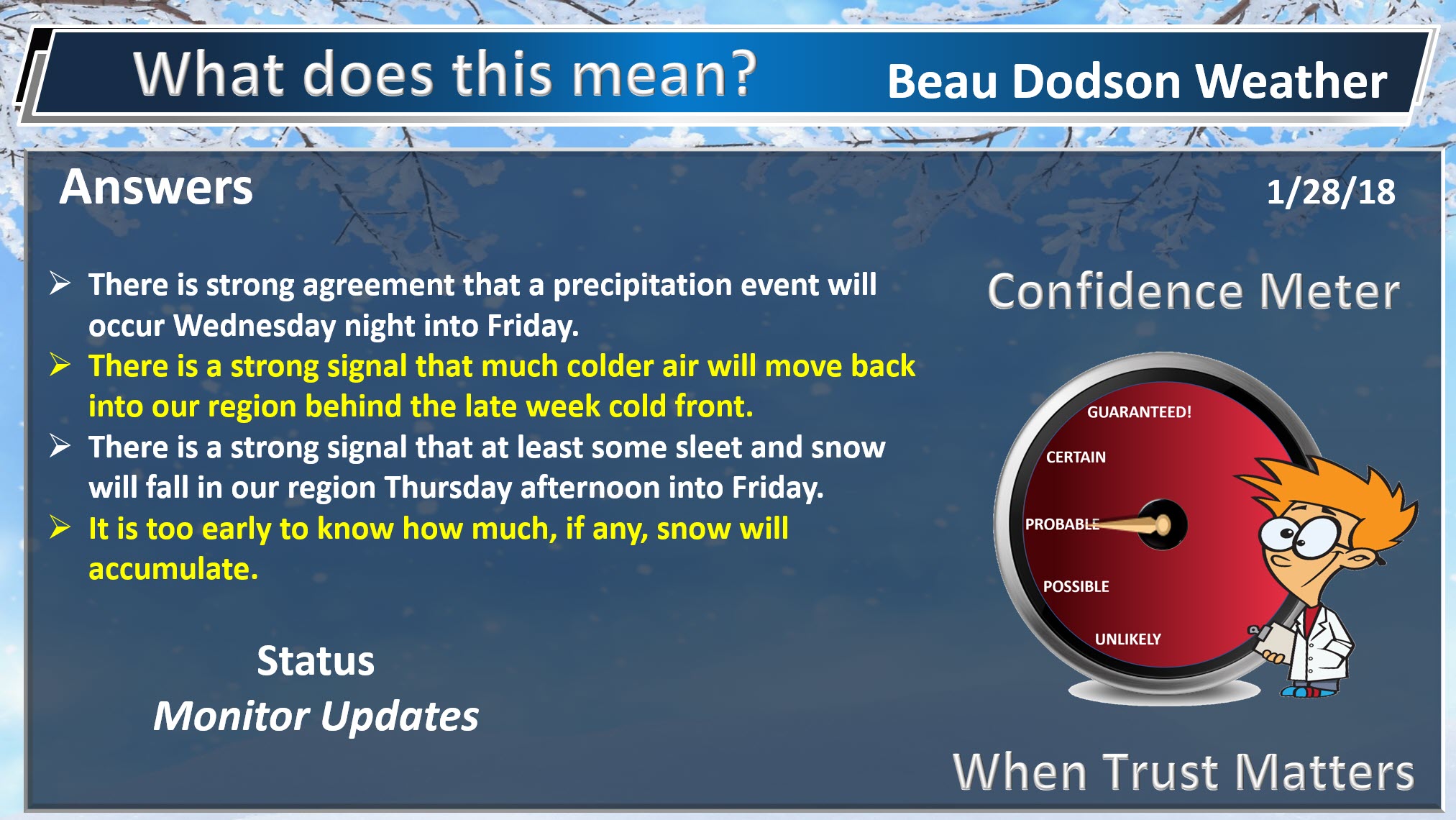
Today through Wednesday afternoon: A fast moving disturbance may deliver some snow showers Sunday night and Monday morning. Accumulations of nothing to perhaps a dusting in some areas. Best chance of a dusting would be across southern Illinois into northwest Kentucky. Lesser chances elsewhere. Temperatures will rise above freezing on Monday. Many areas may not even see snowflakes. High confidence.
I am tracking a winter storm for Thursday into Friday. Details, of course, remain a bit murky. This system is still days away. As many of you know, forecasting snow can be difficult 24 hours in advance let along days in advance. Medium confidence.
At this time, it appears another arctic cold front will push into the region on Thursday/Thursday night. Temperatures will fall sharply behind the front. Rain will turn to sleet and snow as the cold air nudges southward. High confidence.
There remain questions about how much precipitation will fall.
If you have travel plans for Thursday into the weekend then you should monitor updates forecasts and have a plan B.
Bitterly cold air is anticipated Friday night. Single digits are possible, especially if we have a blanket of snow.
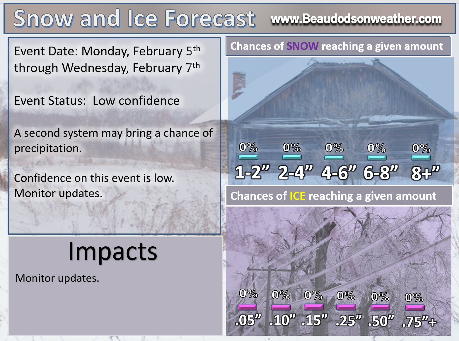
A third system is possible around February 5th through February 8th. Long way off. Confidence is low.
.

.
The National Weather Service definition of a severe thunderstorm is one that produces quarter size hail or larger, 58 mph winds or greater, and/or a tornado.
Now through next Wednesday: No severe weather concerns.
.

.
Interactive Weather Radar Page. Choose the city nearest your location: Click this link.
Short term outlook:
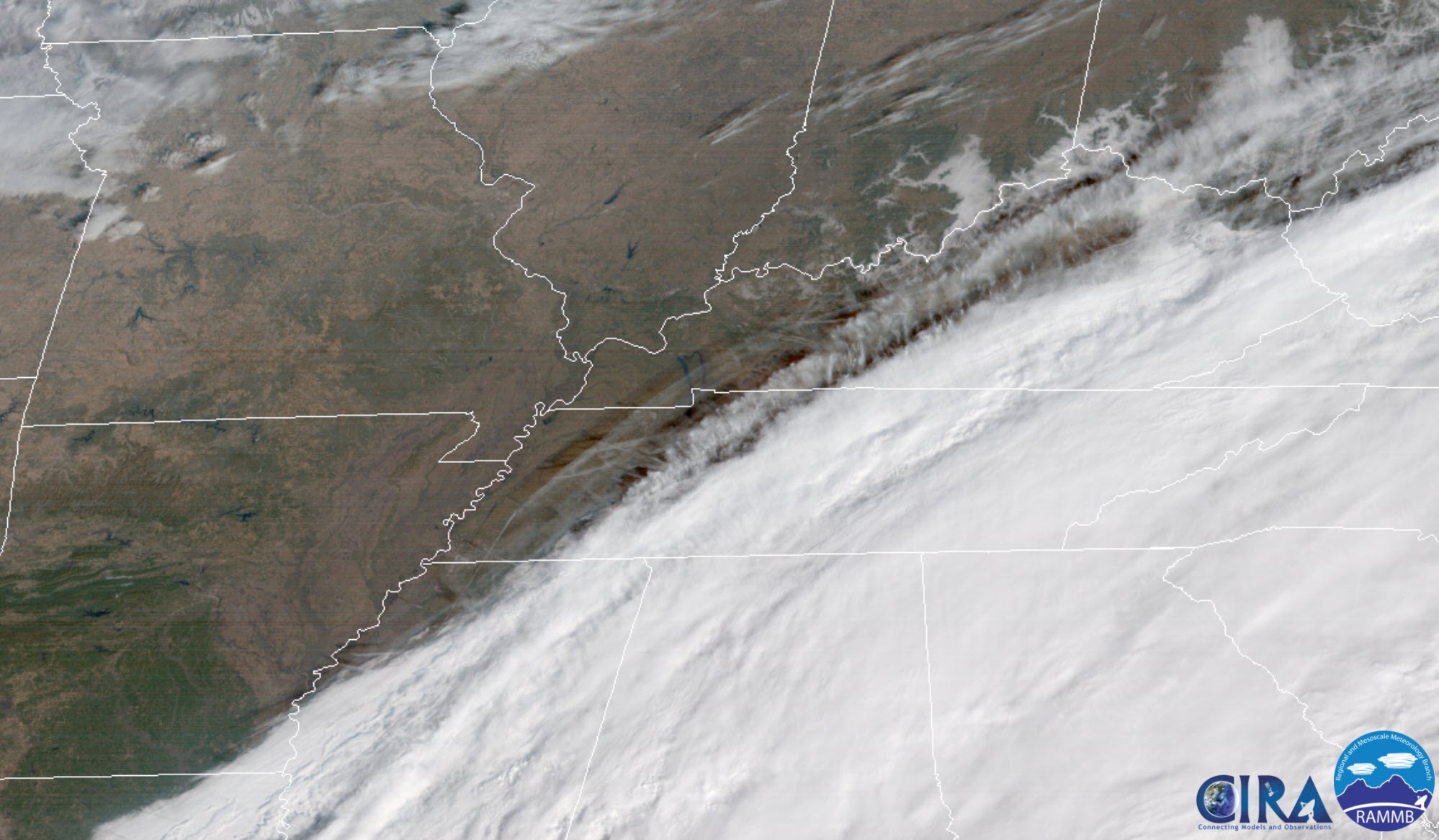
Fog has mixed out and that has left us with mostly sunny sky conditions across the area for your Sunday afternoon.
No precipitation to worry about through the first half of tonight.
Here is the satellite view. You can see the thick clouds off to our east. Those will continue to push away from our area.
.
.
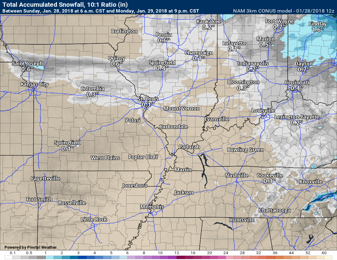
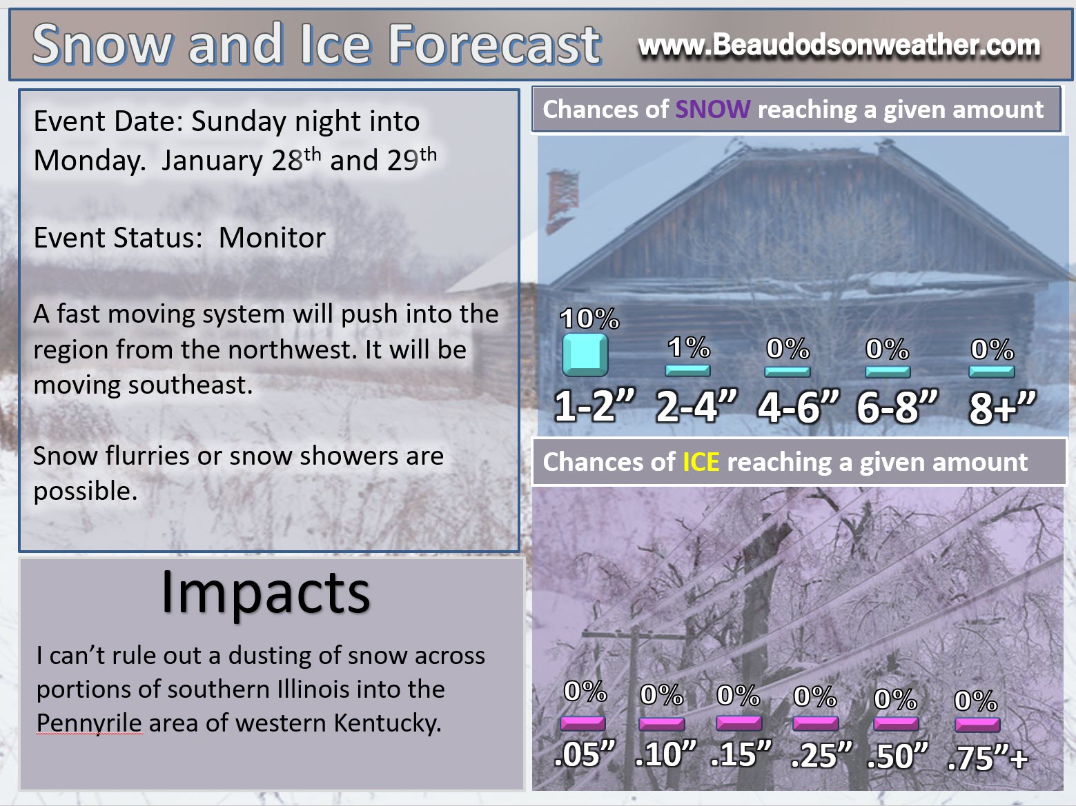
A weak system will race from northwest to the southeast late tonight and on Monday. A band of light snow flurries and snow showers will be possible with this system. Scattered reports of a dusting of snow are possible. The best chance of this happening would be over southern Illinois and northwest Kentucky.
Many areas may not even see a snowflake.
Temperatures on Monday will rise above freezing.
Here are three different models. The NAM, the NAM 3K, and the GFS. You can see that they paint little in the way of accumulation. Perhaps a spotty dusting.
.

.
.

.
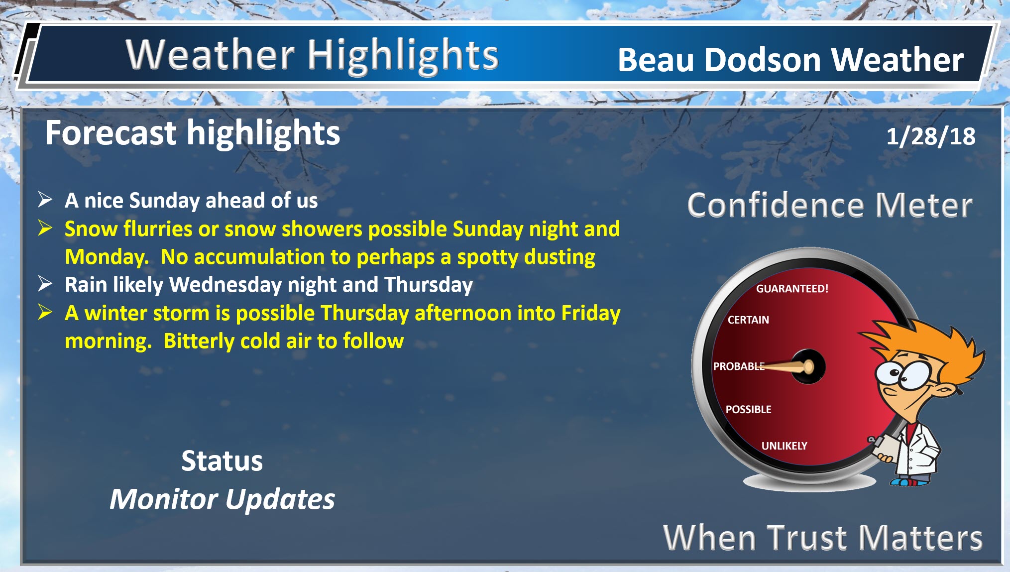
Beau’s Winter Weather Outlook
WHAT and when? Light snow showers possible Sunday night and Monday morning. Confidence is medium.
WHAT and when? Sleet and snow possible Thursday afternoon into Friday. Confidence is medium.
WHAT and when? A third system possible February 5th through 8th. Confidence is low.
WHERE? Sunday night and Monday would most likely be across southern Illinois into northwest Kentucky and the Pennyrile area of western Kentucky. A dusting of snow can’t be ruled out, but odds are against higher totals. Many areas may not even see a snowflake. Temperatures will rise above freezing on Monday.
WHERE? Area-wide event possible Thursday afternoon into Friday. Southeast Missouri, southern Illinois, western Kentucky, and northwest Tennessee.
WHERE? The third system (February 5th through the 7th) would be area-wide, as well. Southeast Missouri, southern Illinois, western Kentucky, and northwest Tennessee.
.
.
.
.

.
This first graphic is for Sunday night and Monday. A weak fast moving system could deliver a few snowflakes.
Confidence is high that there will be some snowflakes in the air. Confidence on accumulation is low.
.
.
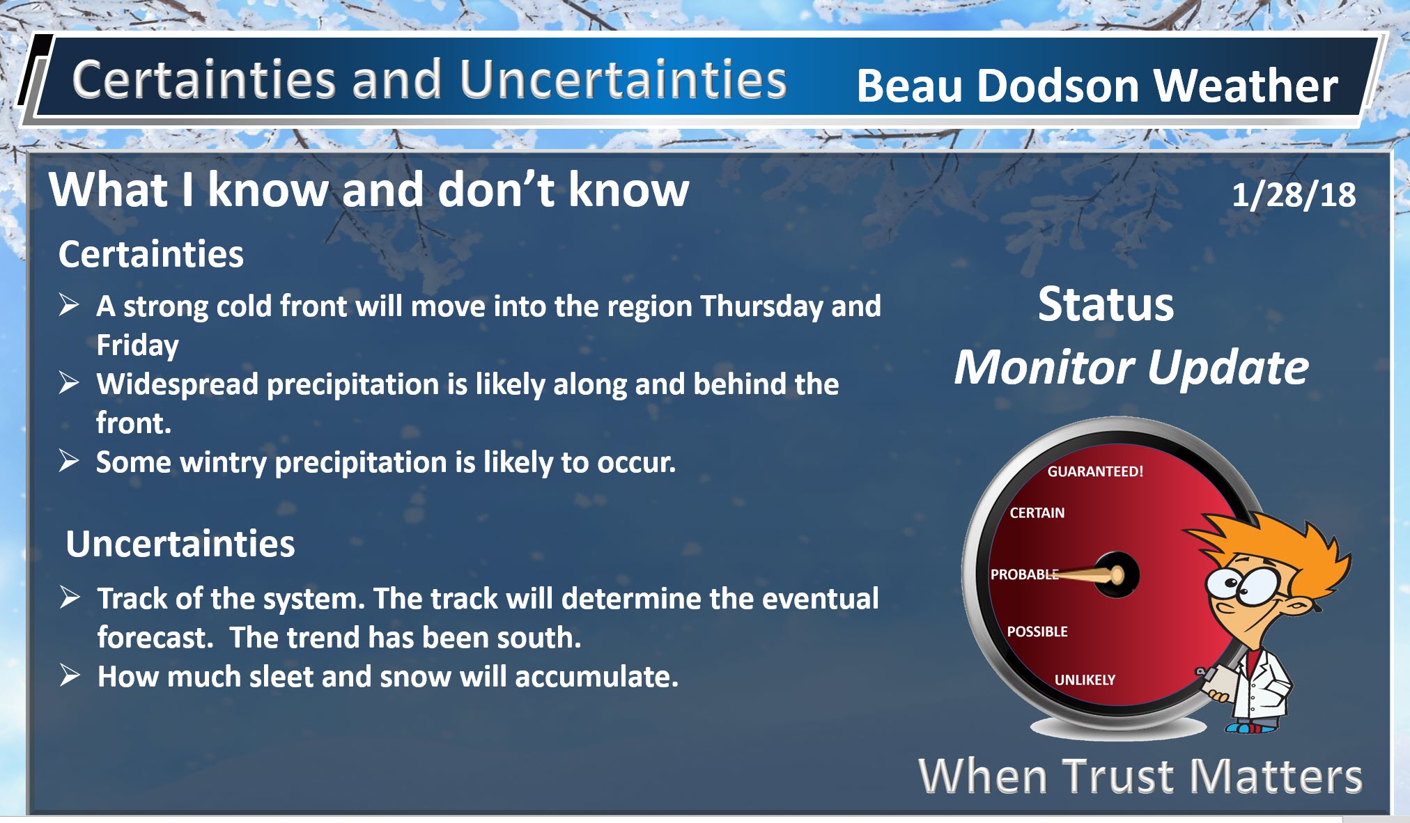
The Wednesday night through Friday system:
Confidence that there will be precipitation Wednesday night into Friday is medium to high.
Confidence on what type of precipitation is medium.
Confidence on how much precipitation is low.
Status? Monitor updates.
My current forecast is rain developing Wednesday night. Rain is likely on Thursday.
A cold front will push through the region on Thursday. Temperatures ahead of the front will likely be in the 40’s and 50’s. Temperatures behind the front will fall into the 20’s and 30’s.
Most of the precipitation will fall behind the cold front.
It might be tricky to pre-treat roadways. Rain ahead of the system could wash the chemicals off the road. This will need to be monitored. Assuming we have precipitation.
Rain should change to sleet and snow from north to south on Thursday afternoon and evening.
Snow is possible Thursday afternoon or night into into Friday morning. Some accumulation is possible, but it is still way too soon to know the answer to that question.
It is still too early to be predicting how much (if any) snow will accumulate.
.

.
A second system is possible around February 5th or 6th. Low confidence on that one.
Some model guidance has sped this system up. Some guidance shows it on Sunday and Monday vs Monday and Tuesday.
.
.
Monitor updates, because the forecast will need adjusting.
Wednesday night into Friday
The next big weather story will be a storm system that will bring rain to our region on Wednesday night into Thursday. A strong cold front will be moving south across our region. Rain should turn to sleet and snow as the colder air arrives.
How much snow remains a question.
You can see the cold air arriving in this GEM weather model animation.
Time stamp is located in the upper left portion of the graphic.
Click to enlarge
Brrr (here we go again)
Couple of things to keep in mind.
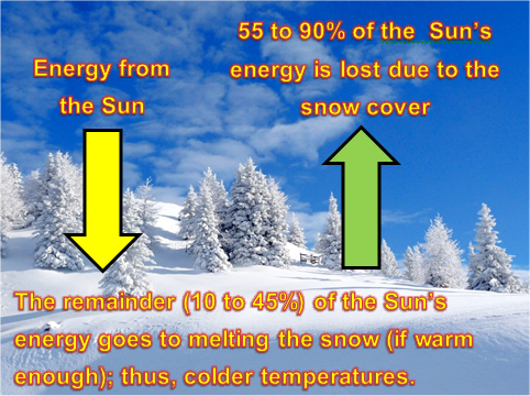
- A deeper snow pack will mean colder temperatures.
- If we don’t have accumulating snow then it will still be cold, but not as cold.
.

.
Rain will likely be falling across the area before the snow arrives. This raises concerns for transportation departments being able to treat the roads. This is what happened during our previous two winter storms. This made travel difficult. The sleet also made it worse.
At this time, it doesn’t appear there will be as much sleet with this event as the previous one. Still early for certainties.
This graphic below is the future-cast radar from the GFS model guidance. Green represents rain. Blue would be snow. This is what MIGHT look like as we move into Thursday and Friday.
This morning’s run of the GFS model shows no storm system at all. It lost the system. It now shows a system on Saturday and Sunday.
Again, this is ONE models opinion. There are many different models. No one model is ever exactly right.
Models are for guidance and are not gospel.
.
.
The GFS now shows wintry precipitation moving into our region on Saturday and Sunday. This is the first time the mode has shown this solution. I am skeptical based on what everything is showing. As always, I will be monitoring trends in the guidance.
Green is rain. Blue is snow. Pink/purple is sleet and freezing rain.
.
.
Here is the Canadian model guidance future-cast radar for Wednesday night into Friday.
There is NO agreement between the operational (main) GFS model and the Canadian model.
.
.
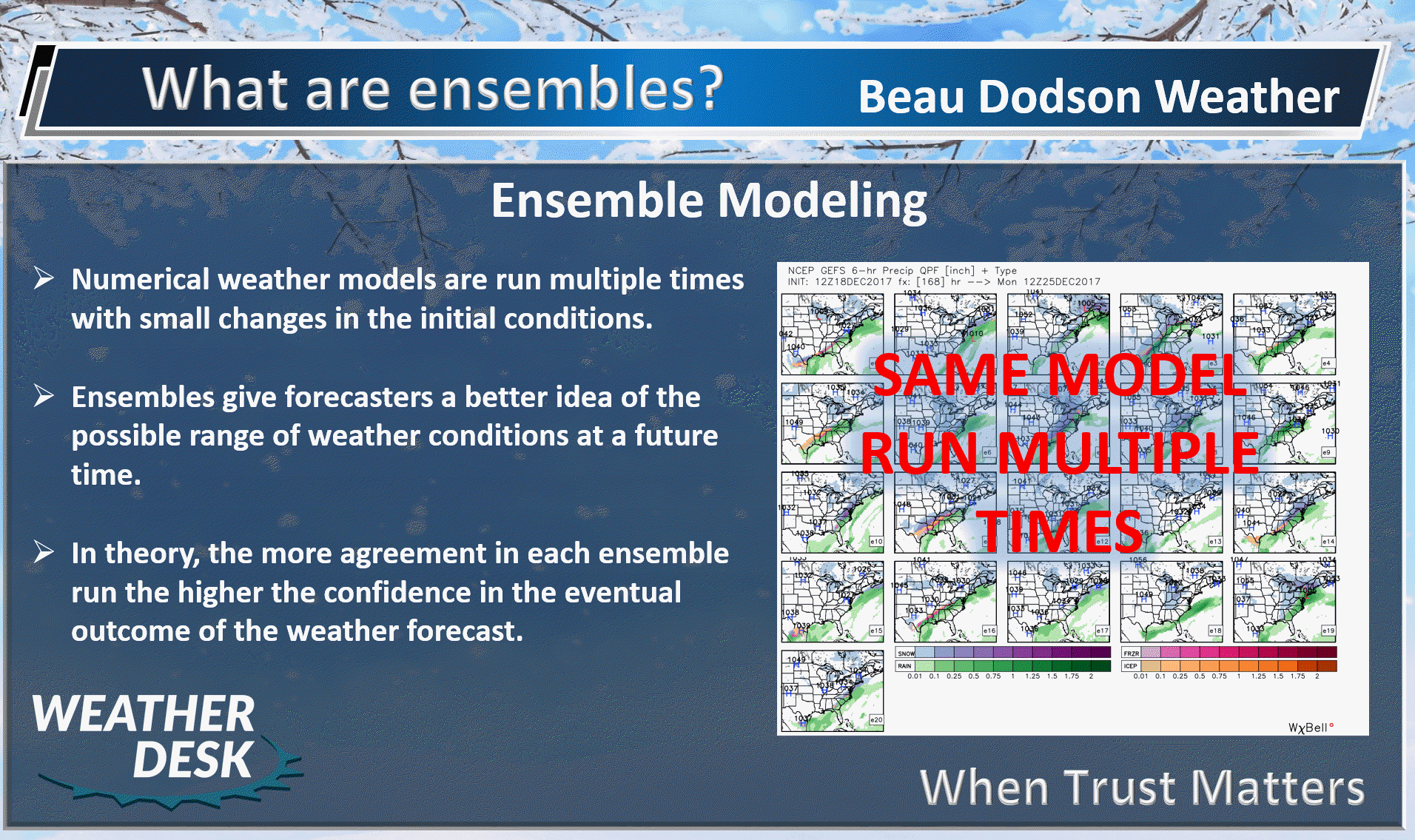
Let’s look at some ensemble data. What are ensembles? See this post that I made last night. Click here.
Click image to enlarge images
.
.
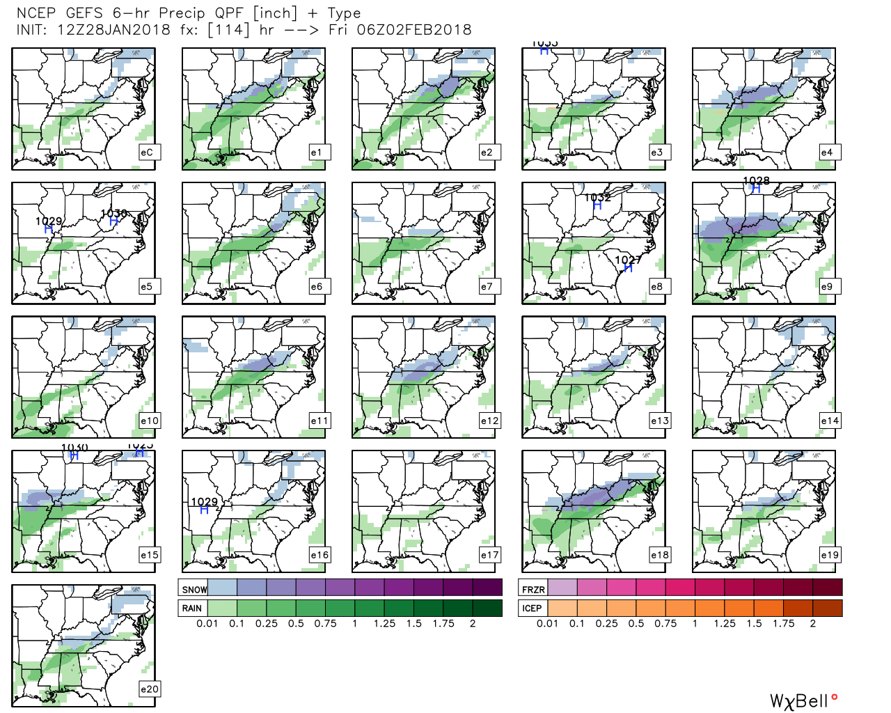
I am going to post the GFS ensembles. Each graphic represents the time stamp above it.
The ensembles are NOT in agreement with the main operational run of the GFS (the one I posted above).
That means the main operational run of the GFS is the outlier. Meaning, most of the other models do not agree with it. It is something I will be monitoring over the coming days.
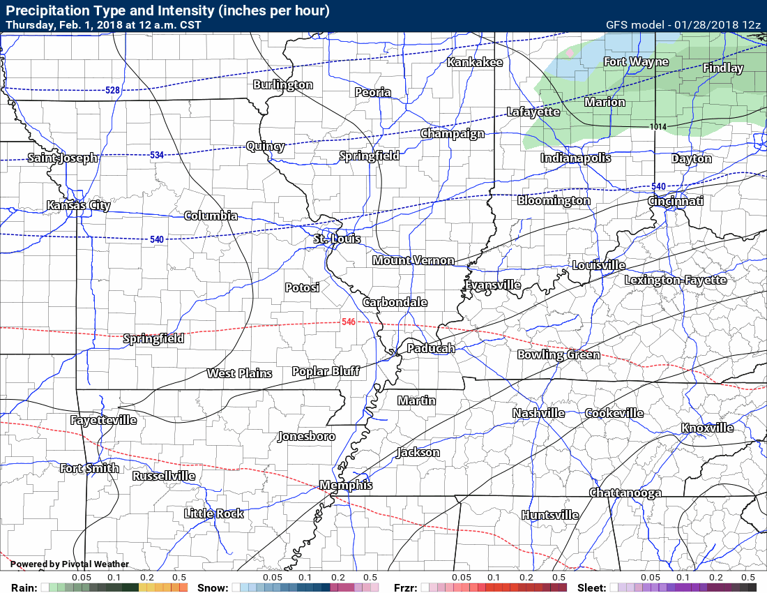
The first one is 6 PM Thursday.
You can see quite a few of the squares have green over our region. That means that quite a few of the ensemble members believe it will be raining here by Thursday morning.
I would agree. It does appear precipitation is likely to occur on Thursday morning and it should be in the form of rain.
Remember, the more squares that agree with each other, the higher the confidence in the forecast. It does not mean that is what will happen. It is one models opinion on the weather pattern.
Each square represents 6 PM Thursday. It square represents the previous six hour precipitation totals. So this first one would be precipitation totals between 12 PM Thursday and 6 PM Thursday.
Each square is one run of the GFS model.
(in case you missed this post) What are ensembles? See this post that I made last night. Click here.
Click image to enlarge
This is a BIG change from 24 hours ago. The GFS is now showing numerous squares with no precipitation at all. This raises questions. This is a large shift in the model guidance. Normally, large shifts raises doubts in what it is showing. With that said, we still have a long way to go on this one.
There have been some trends for the system to push further south. This will need to be monitored.
.

.
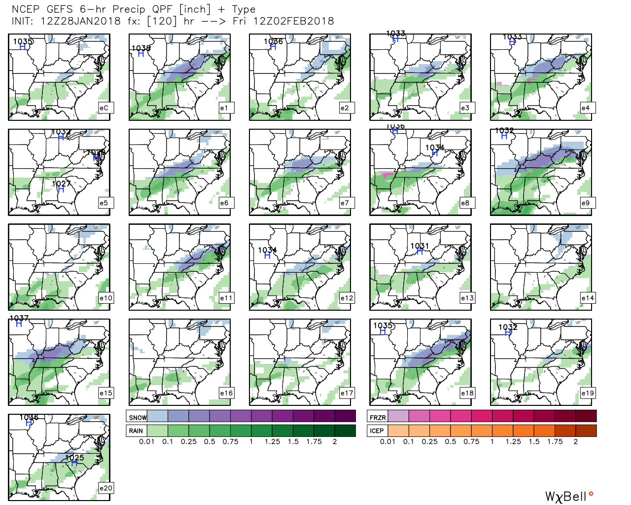
This next image (below) is 12 AM Friday
There are numerous squares with snow (blue/purple). The orange color represents sleet.
The bulk of the squares show some precipitation.
12 AM Friday, the GFS is all over the place. No precipitation. Rain. Snow. It shows a lot of different scenarios. That raises a lot of questions about confidence levels. The GFS has made significant adjustments was just 12 to 24 hours ago.
Click image to enlarge.
.
.
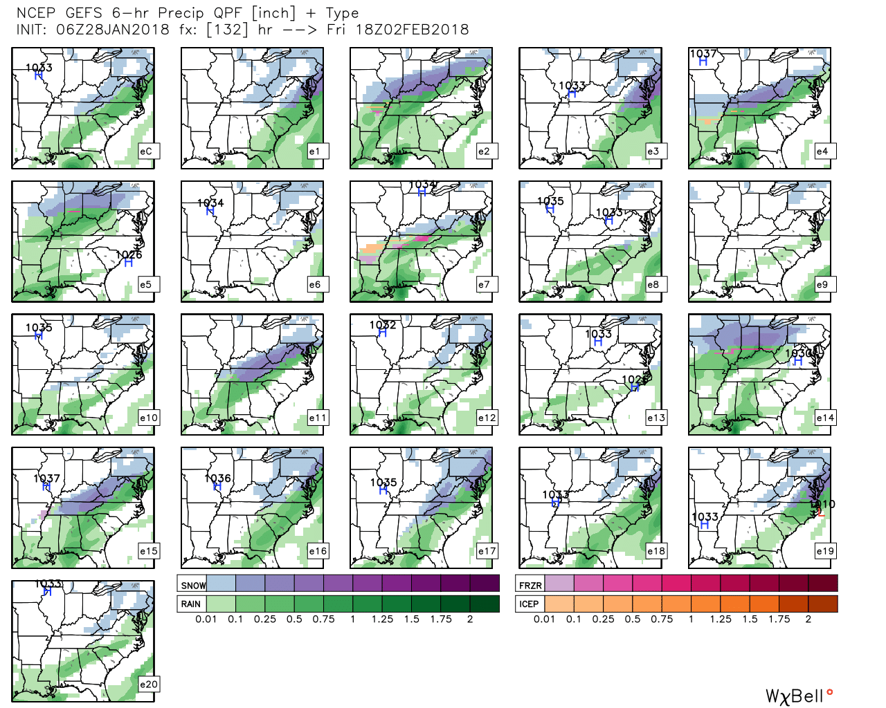
This next image represents 6 AM Friday
Again, it is all over the place. Some model runs show no precipitation. Some show rain. Some show snow.
Confidence in the GFS model solution is low.
Often times models tend to lose systems in this time frame. They then return to earlier solutions once we draw nearer to the event.
Many questions remain about this precipitation event. Monitor updates, as always.
Click image to enlarge
.
.
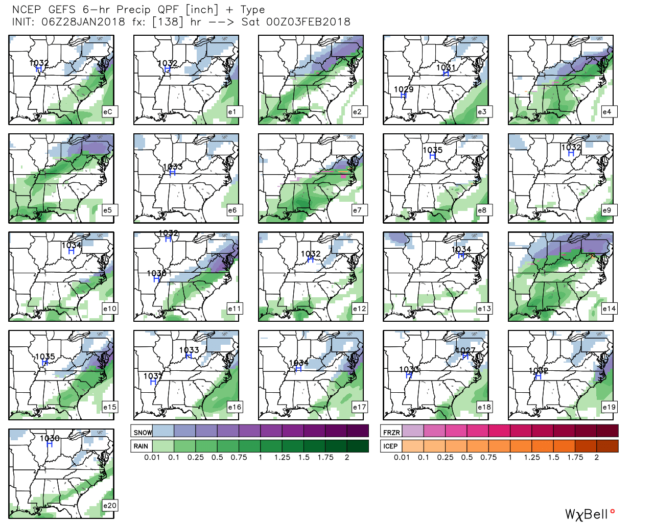
This next image is for 12 PM Friday
Again, all over the place. No precipitation. Rain. Snow. GFS has many different possible solutions.
.
.
This next image is for 6 PM Friday
The GFS ensembles are showing different solutions. No consistency. This lowers confidence in what the GFS is showing.
.
.
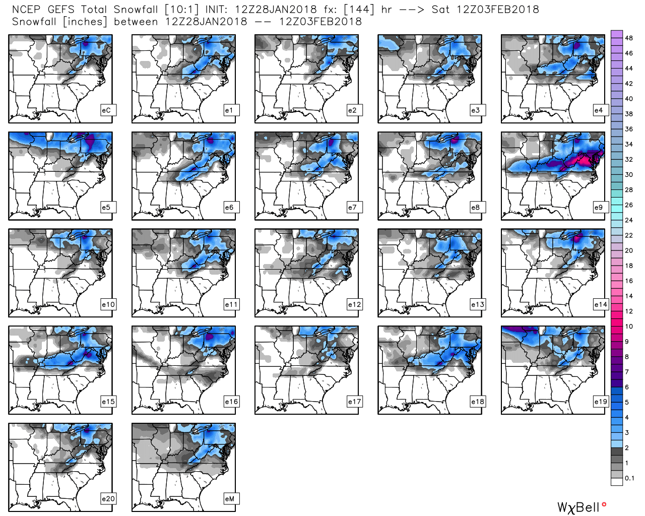
Now, the fun part.
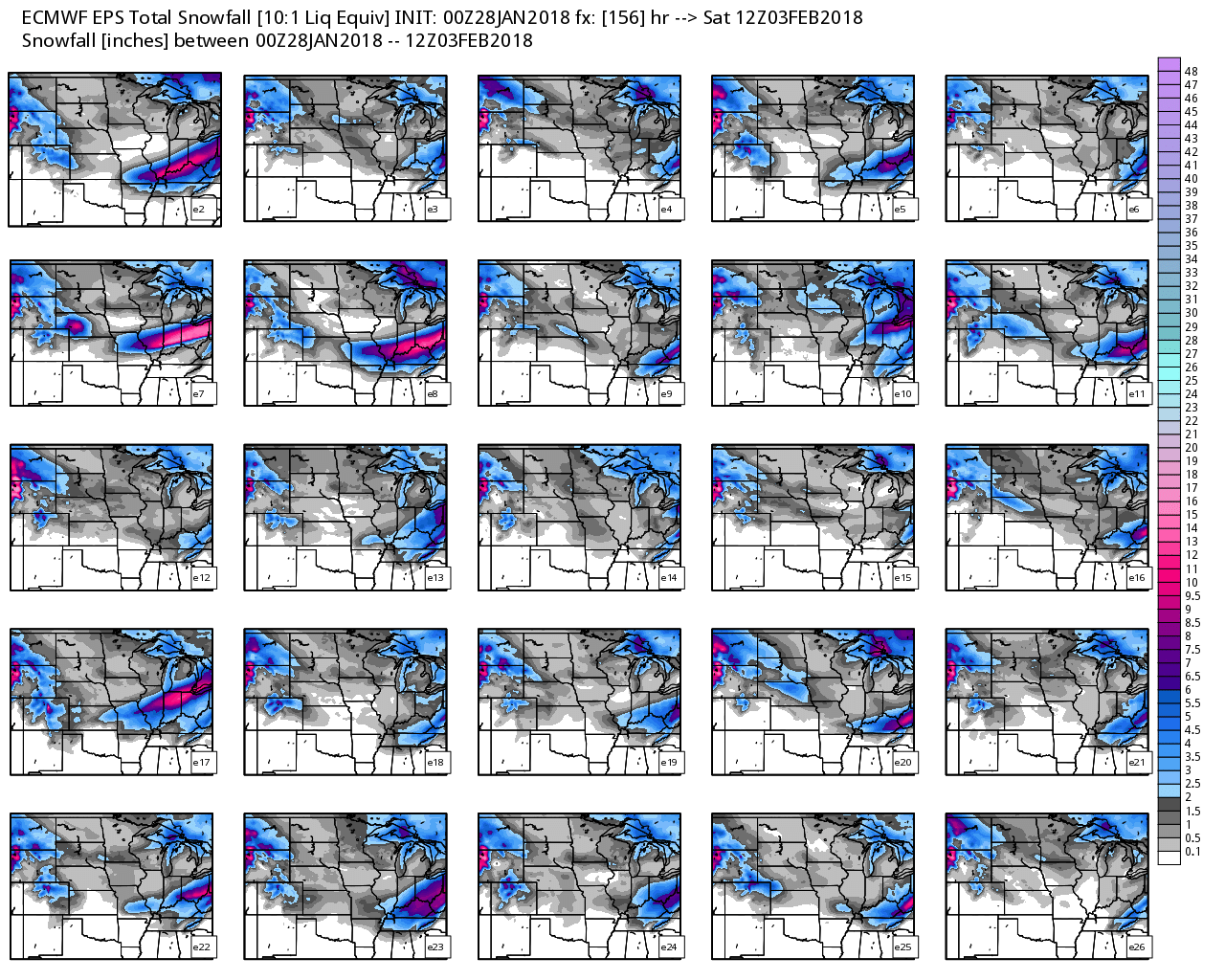
Each of those squares is one run of the GFS model. In other words, if you added up all the squares from the above images, what would their snow totals be?
You see a WIDE range of totals. We don’t know yet how much (if any) snow will accumulate.
I am just showing you the raw model output. The raw graphics.
The scale is on the right side of the graphic.
This is through 6 AM Saturday.
Many panels now show no measurable snowfall.
Click images to enlarge them
.
.
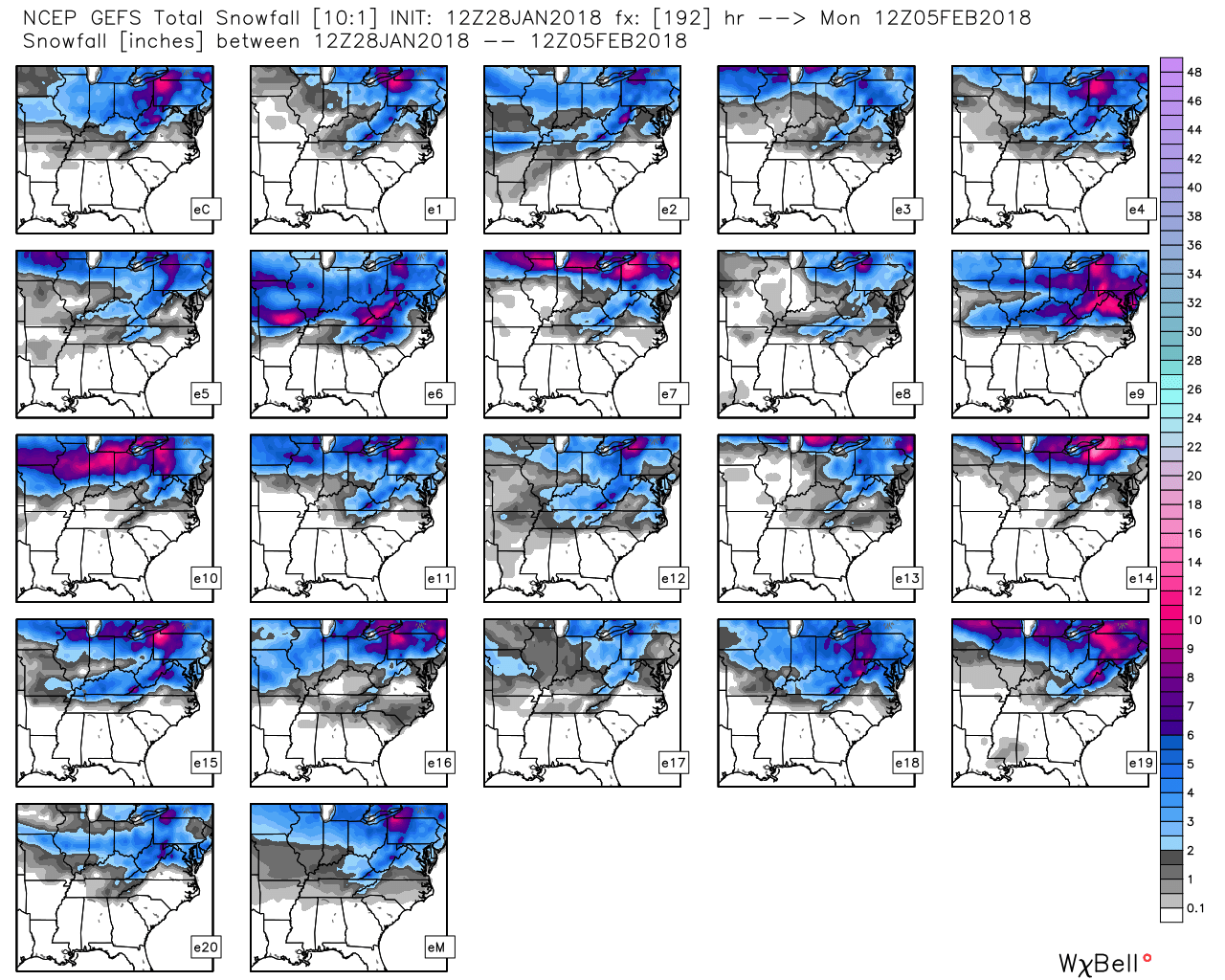
The GFS, however, does show snow accumulation Saturday night into Monday. This is a big shift from previous runs.
.
.
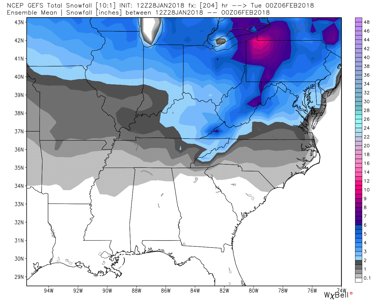
How about the mean. What does MEAN mean? The MEAN is the average of all of the models.
This is the GFS ensemble MEAN for snowfall totals.
Will this happen? I don’t know, yet.
This is just the GFS models opinion. Each model is different.
The fun part of this is that the model runs four times a day. That means it will likely change, somewhat, four times a day.
If the models keep showing he same end result over and over again then our confidence in the forecast will increase.
We don’t chase models. In other words, I already have a forecast in mind for this event. I have to monitor trends in guidance to fine tune that forecast.
My forecast philosophy is to ramp up and not down. That means don’t put out BIG totals early on. I won’t have higher confidence until Wednesday.
I am also a big believer in monitoring trends. The trend is your friend. In other words, the trends usually tell you more than just one model run.
The GFS decreased totals from yesterday’s data.
.
.
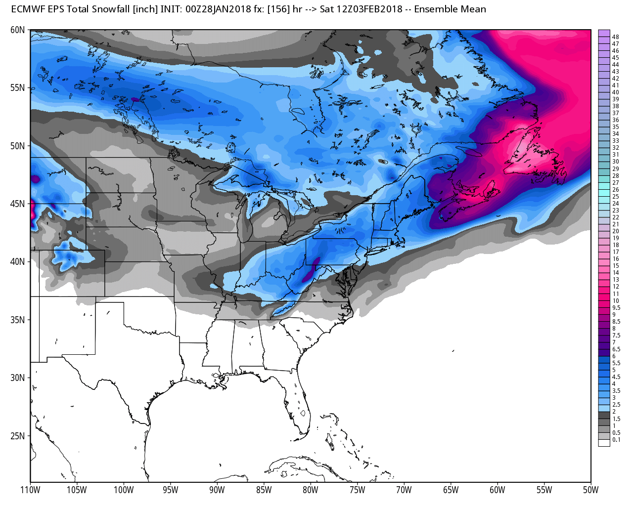
Let me show you another model. This is the EC. The EC is the European model.
Here is the MEAN snowfall from the EC model.
Notice the differences between the two models.
There was not much change in today’s EC model run vs yesterday.
.
.
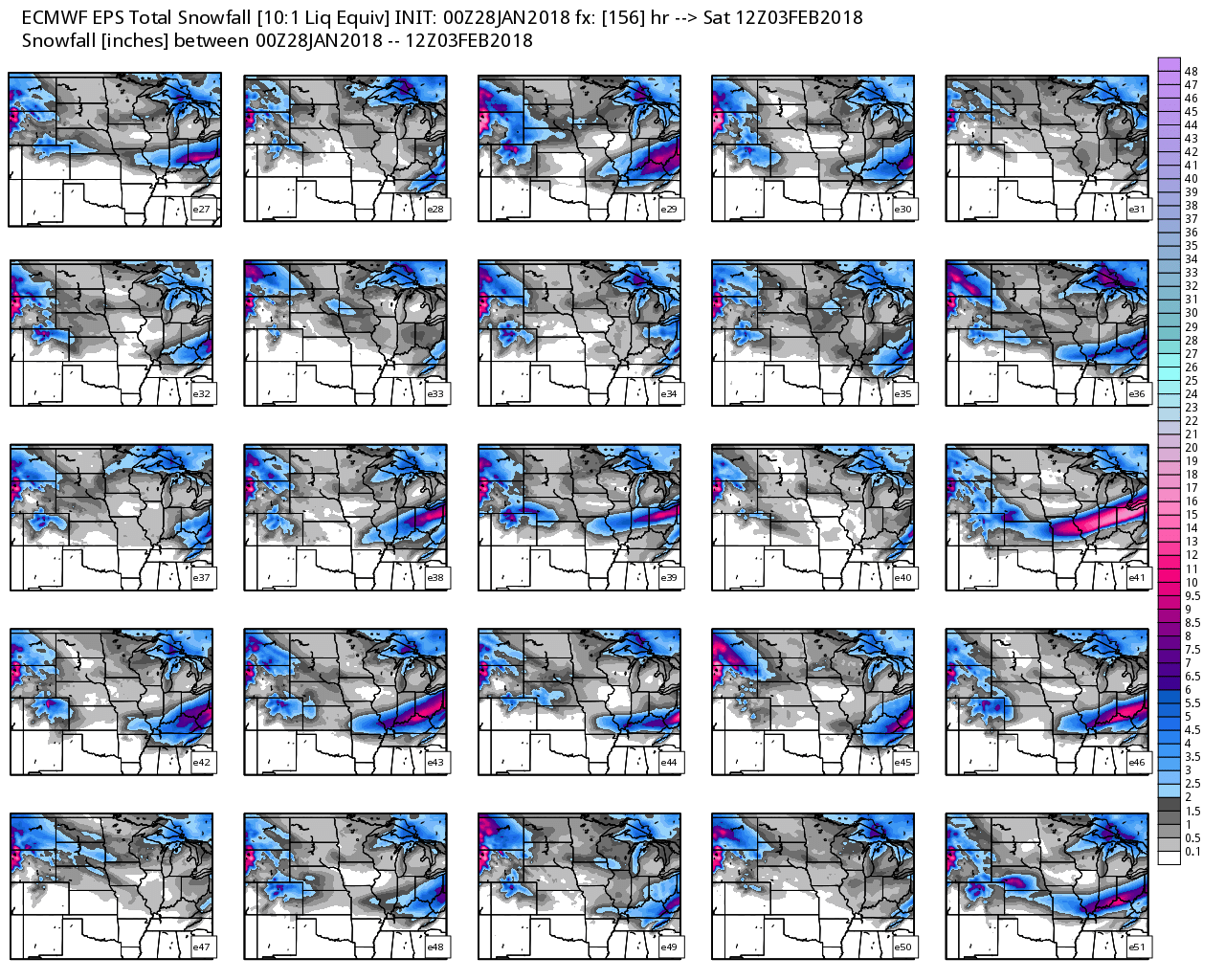
Let me show you the EC ensemble panels.
Each square represents one run of the EC model. Each square is showing you the total amount of frozen precipitation that each run is forecasting.
Some of the squares show very little if any snow or ice. Some squares show quite a bit.
Click to enlarge
.
.
The EC model has more ensemble squares than the GFS. That is why there are two graphics.
Here is the second EC ensemble forecast panel.
.
.
Colder air will follow the winter storm. IF we have snow on the ground, then temperatures may dip into the single digits. This is highly depend on snow cover.
.
.
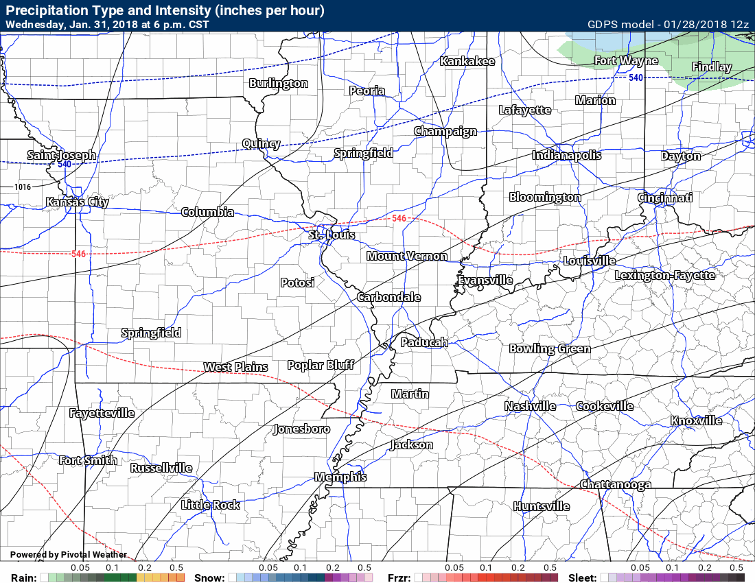
These temperatures are from the GFS model. If we have snow on the ground then it will be colder.
We start off quite mild on Wednesday. This is the 6 PM Wednesday temperature forecast.
.

.
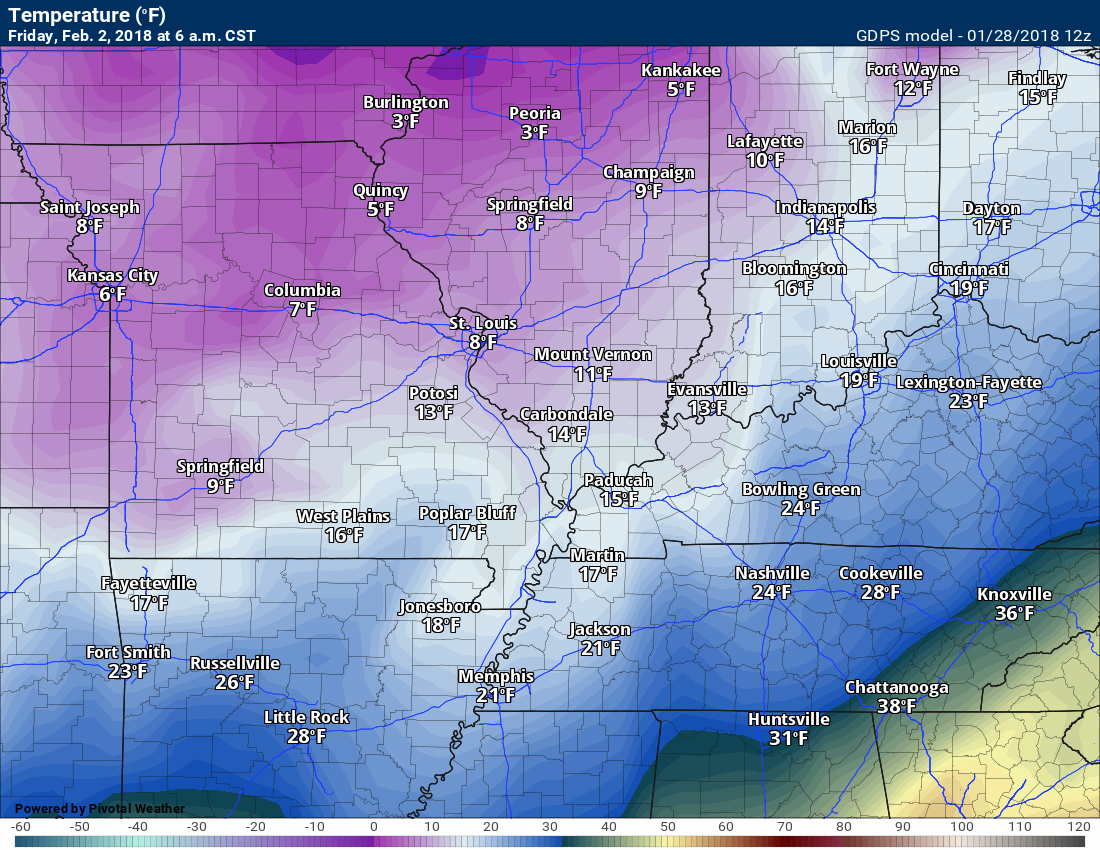
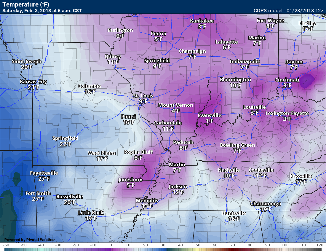
Here is the 6 AM Friday temperature forecast from the GEM model.
The GFS model is warmer, because it did not show any snow on the ground.
The GEM model is colder, because it does have a blanket of snow over our region.
.
.
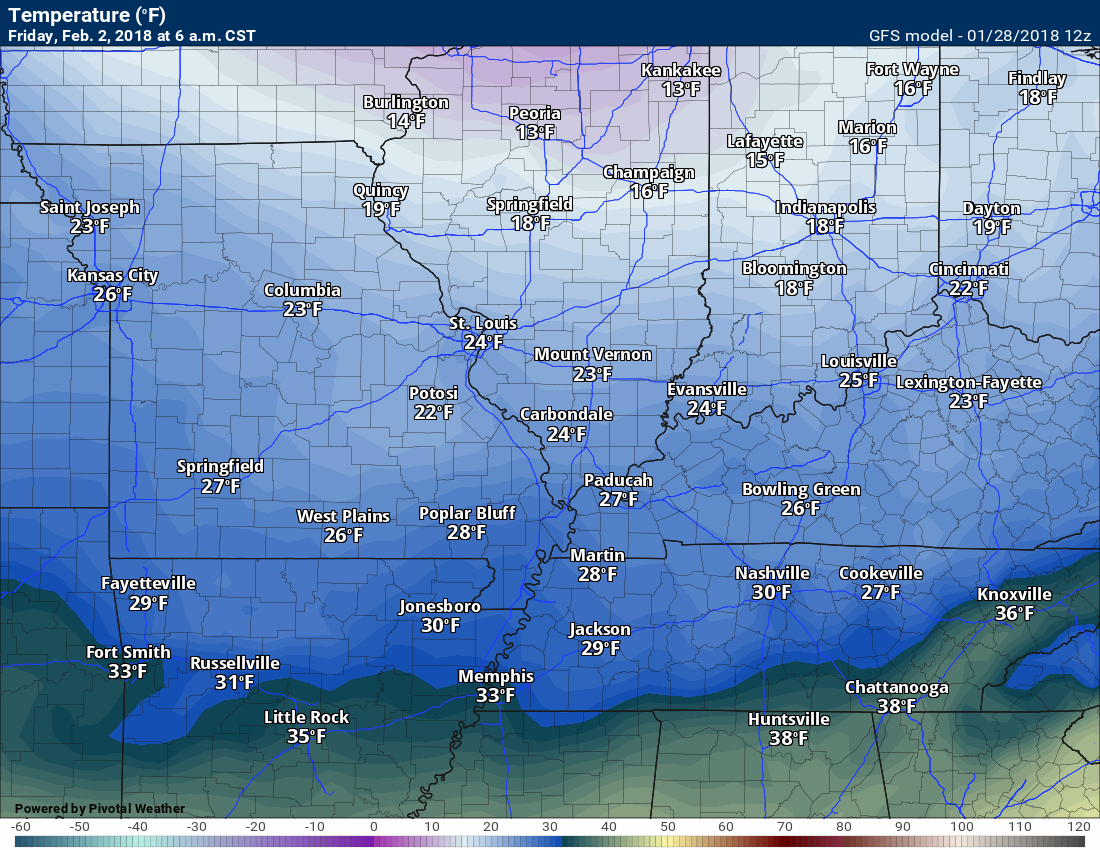
Here is the GFS model for the same time period. Friday 6 AM.
.
.
This next graphic is 6 AM Saturday
Again, to be this cold you would have to have snow on the ground. That remains a big question mark.
.
.
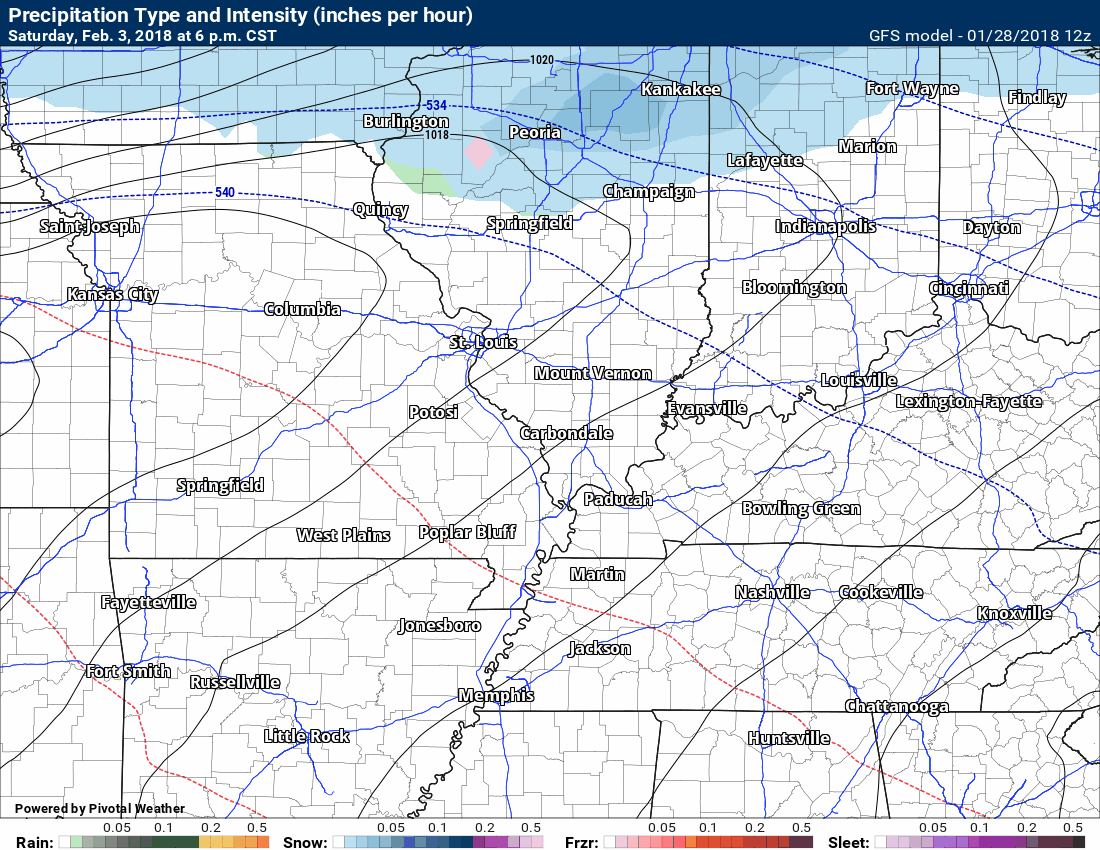
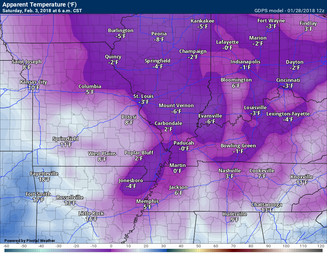
Wind chills would be even colder. Gusty winds are likely with this system.
Here is the 6 AM wind chill forecast for Saturday, February 3rd.
Again, HIGHLY dependent on there actually being snow on the ground.
.
.
A third system is possible around February 5th through 7th. Long way out for that one. Confidence is low.
.


We offer regional radars and local city radars – if a radar does not update then try another one. Occasional browsers need their cache cleared. You may also try restarting your browser. This will usually fix any problems.
During the winter you can track snow and ice by clicking the winterize button on the local city view interactive radars.
You may email me at beaudodson@usawx.com
Interactive Weather Radar Page. Choose the city nearest your location: Click this link
National interactive radar: Click this link.