
Are you in need of new eye glasses? New contacts? Perhaps you need an eye exam. Then be sure and visit the Eye Care Associates of western Kentucky (the Paducah location). For all of your families eye care needs.
Visit their web-site here. Or, you can also visit their Facebook page.

Best at Enabling Body Shop Profitability since 1996. Located In Paducah Kentucky and Evansville Indiana; serving all customers in between. They provide Customer Service, along with all the tools necessary for body shops to remain educated and competitive. Click the logo above for their main web-site.
You can find McClintock Preferred Finishes on Facebook, as well

Expressway Carwash and Express Lube are a locally owned and operated full-service Carwash and Lube established in 1987.
They have been proudly serving the community for 29 years now at their Park Avenue location and 20 years at their Southside location. They have been lucky enough to partner with Sidecar Deli in 2015, which allows them to provide their customers with not only quality service, but quality food as well.
If you haven’t already, be sure to make Expressway your one-stop shop, with their carwash, lube and deli. For hours of operation and pricing visit www.expresswashlube.com or Expressway Carwash on Facebook.

The quad states area source for Precision Ag Technology. Locally owned and operated, specializing in planting, harvesting, fertilizer application and drainage. Visit them on their website and on Facebook. You can also find them on Twitter. They are located in Almo, Kentucky. Phone 270-718-0245

Facebook update Q&A thread Link Click here
1. Make sure your weather radios are in working order.
2. Make sure you have turned on WeatherOne in your text message service. That is the first text message option and is the one I use to send you tornado alerts. Sign up at www.Beaudodsonweather.com
3. Monitor updated forecast, because confidence on what happens Tuesday night and Wednesday morning is low.
Video update
I will update the video several times today
Click on the YouTube logo (bottom right) to enlarge the video. Large size is better for viewing.
This blog page will be updated throughout the day.
Facebook update/Questions and answers
Link to the latest Facebook update CLICK HERE
Tuesday
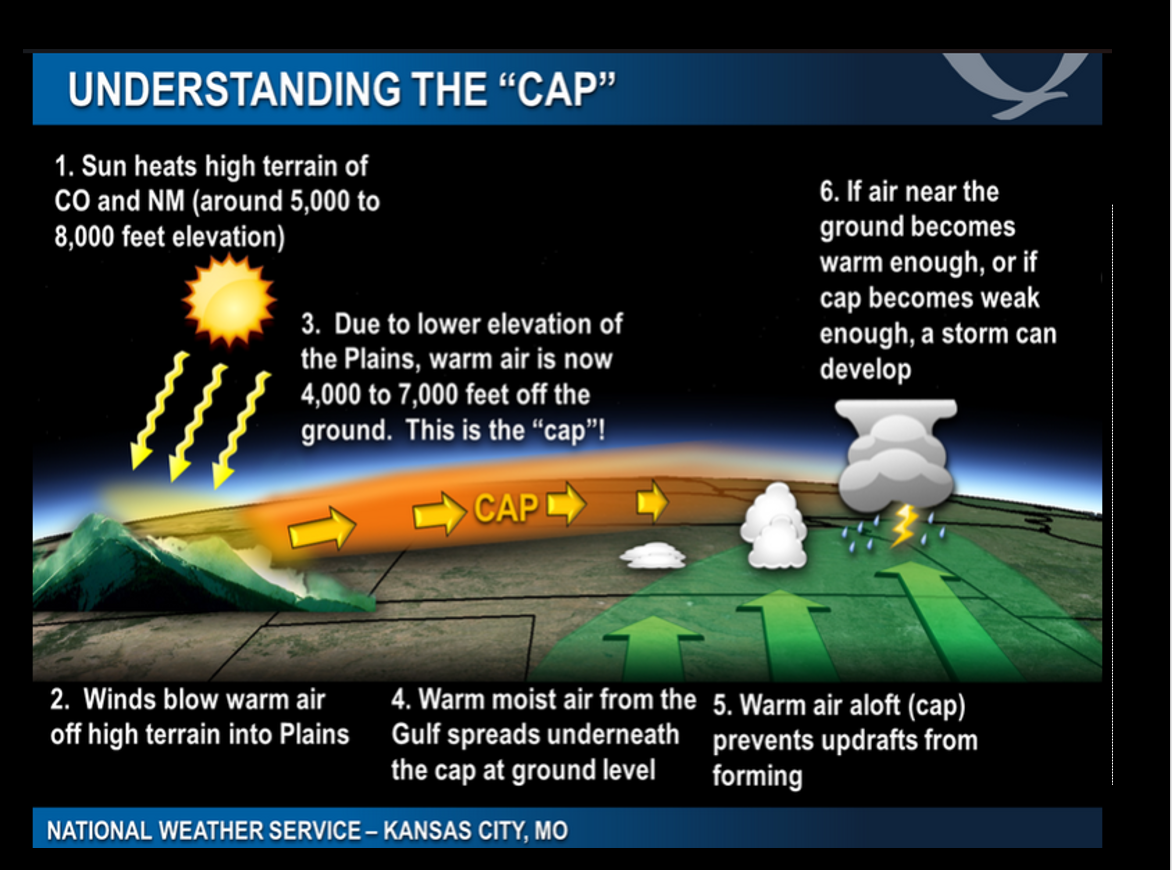
Unsettled day ahead of us. There is a CAP developing. A CAP is like a lid. It prevents the atmosphere from producing thunderstorms. The CAP might hold through much of today. When the CAP breaks then storms form. This will need to be monitored. See the CAP graphic further down in this blog update.
Morning storms will move off to the northeast. New storms could form before sunset (esp over southeast Missouri and southwest Illinois). Some of the storms this afternoon and evening could become severe. Large hail and damaging winds are possible today. A few tornadoes can not be ruled out.
It is impossible to tell you what counties will be hit by severe weather. All I can tell you, at this time, is that some severe weather will likely occur later this afternoon into Wednesday morning. Once storms form, then we can start tracking them and forecast county by county.
A tornado watch will likely be issued later this afternoon and tonight. Multiple watches are likely. A watch means that conditions are favorable for severe weather. A warning means to take action.
Two types of storms are possible over the next 24 hours. A squall line (a line of thunderstorms) will likely form along an incoming cold front. The squall line may not arrive, in our local area, until the wee hours of Wednesday morning. Probably after 2 am. It may not exit our region until after 8 am. It will move from W/NW to E/SE.
The squall line could produce pockets of winds greater than 60 mph, quarter size hail (or larger), and even rain wrapped short-lived tornadoes.
The second type of storms, that could form today, would be supercells. Supercells tend to be scattered. They will move southwest to northeast. If supercells form, then they could move at 60 to 80 mph. Seek shelter, if a warning is issued. You may not have much time to respond.
Supercell thunderstorms tend to produce the longer tracked tornadoes, large hail, and damaging winds.
There remains some questions about whether supercells will or will not form. Most of the guidance does develop supercells.
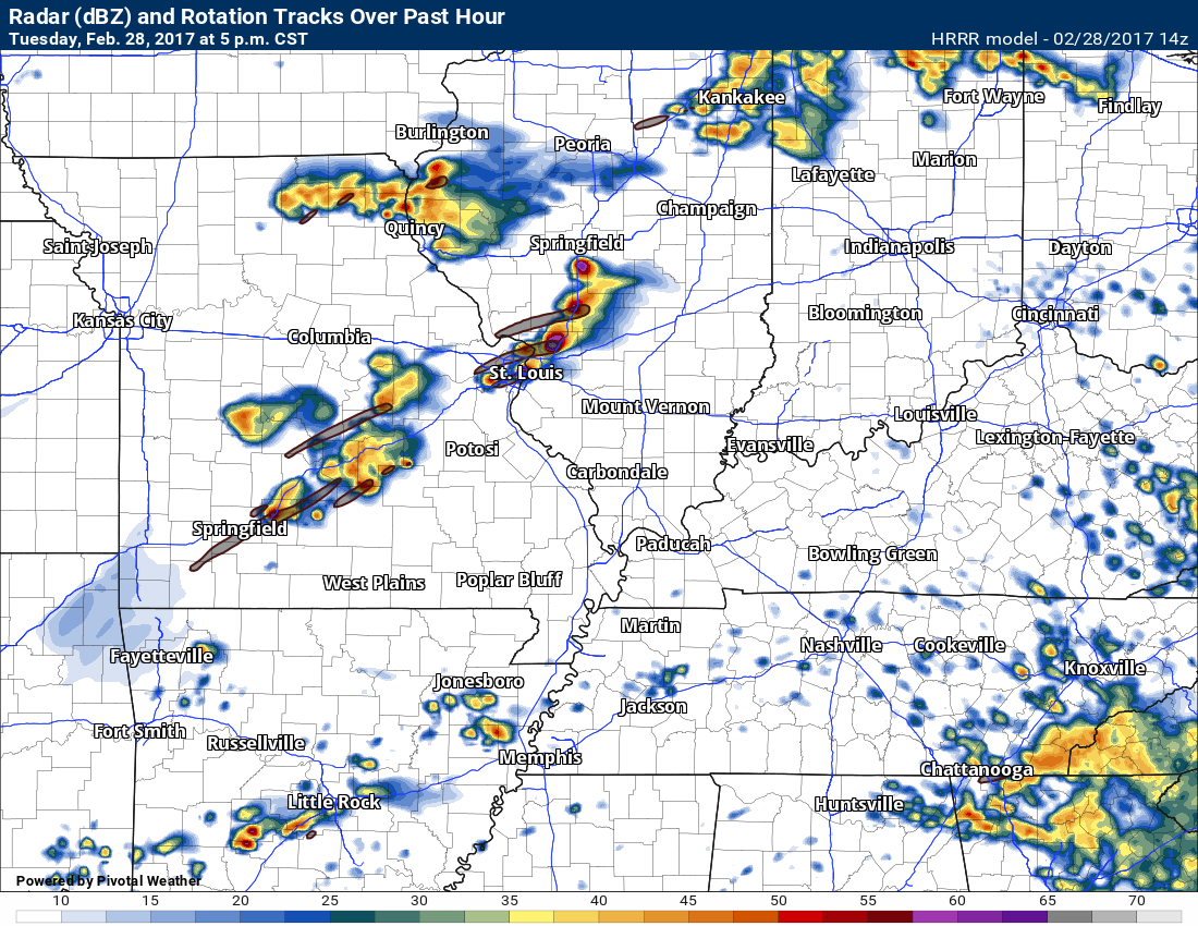
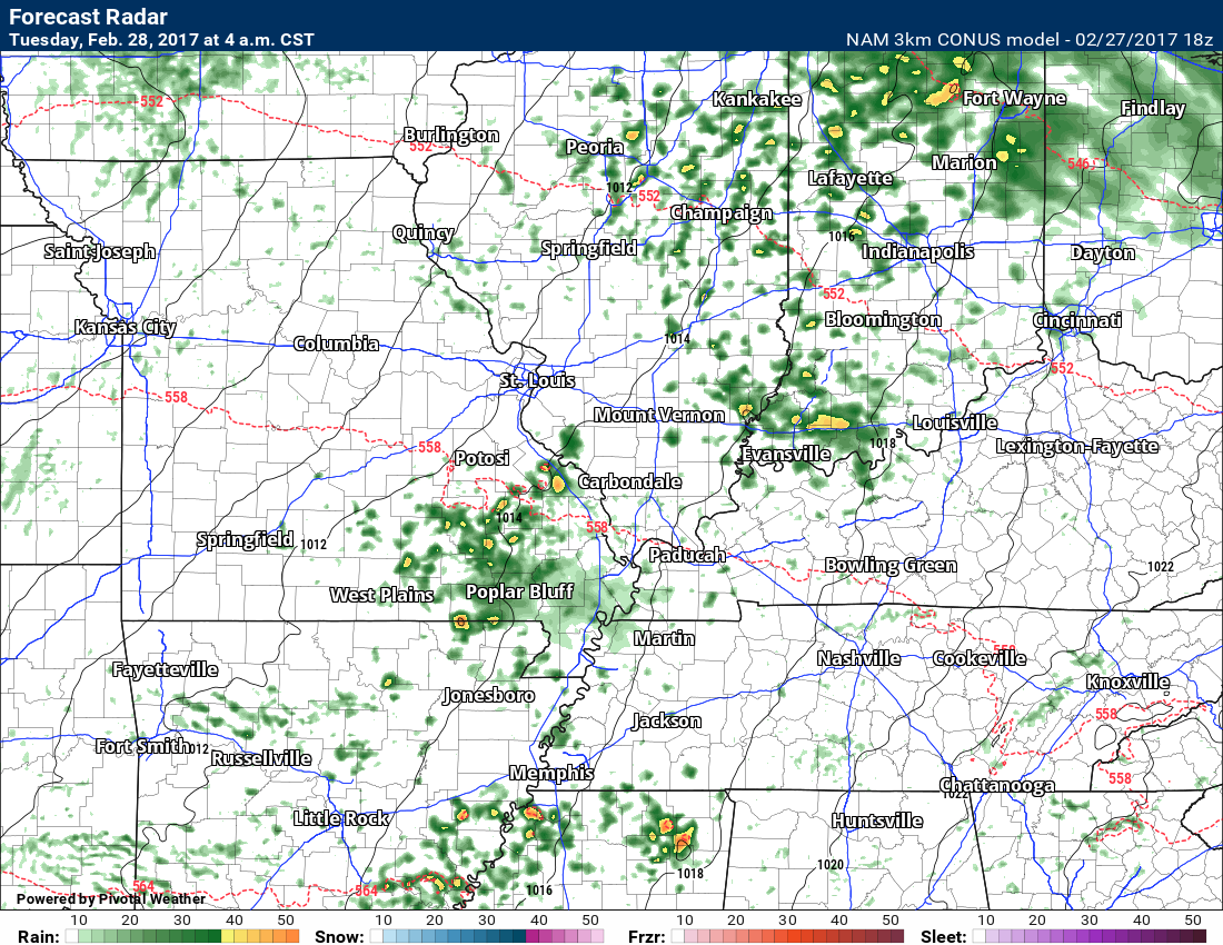
Here is the latest HRRR chart. This is the future-cast radar for later today. This is what radar might look like. Don’t get too hung up on the exact placement of storms. The model is giving you the GENERAL idea of what to expect.
This is the 5 PM future-cast radar. You can see some supercells over portions of Missouri and Illinois. Again, exact placement will need to be monitored.
A lot of the guidance is shifting a bit further northwest.
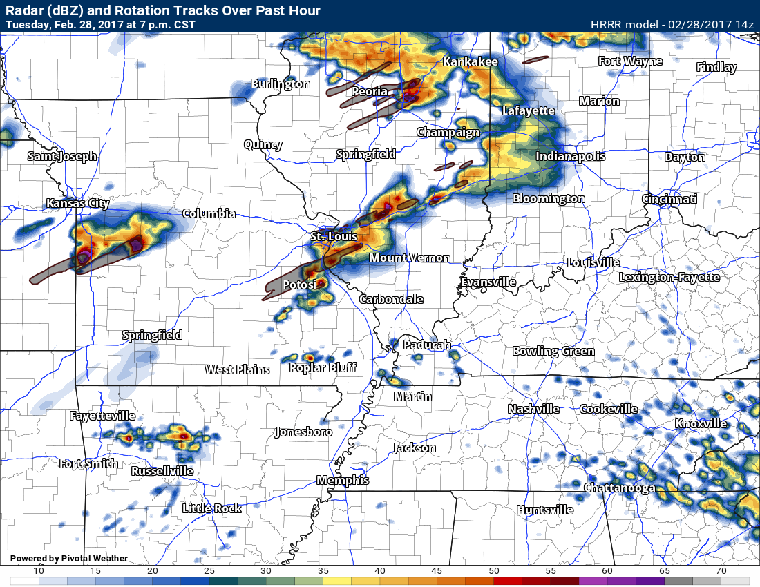
Here is the 7 PM future-cast radar. Again, don’t get too hung up on the exact placement of storms. Take the general idea that the atmosphere is unstable.
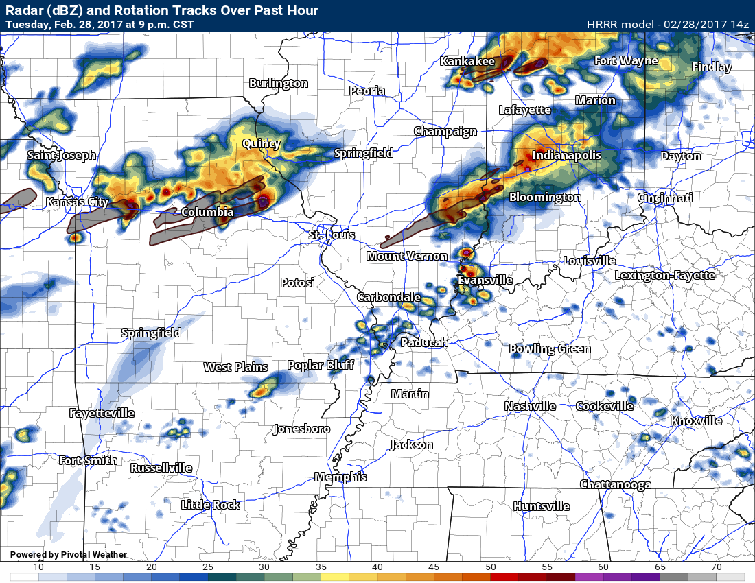
9 PM
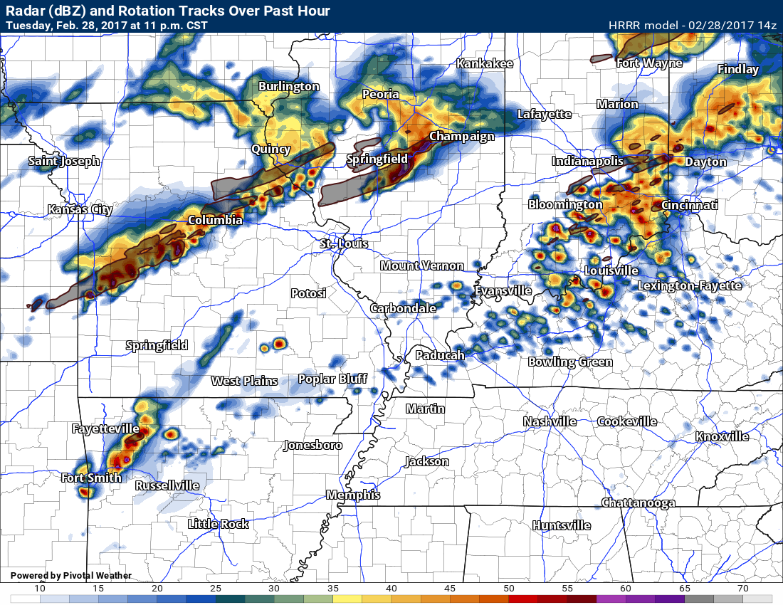
11 PM
3 AM
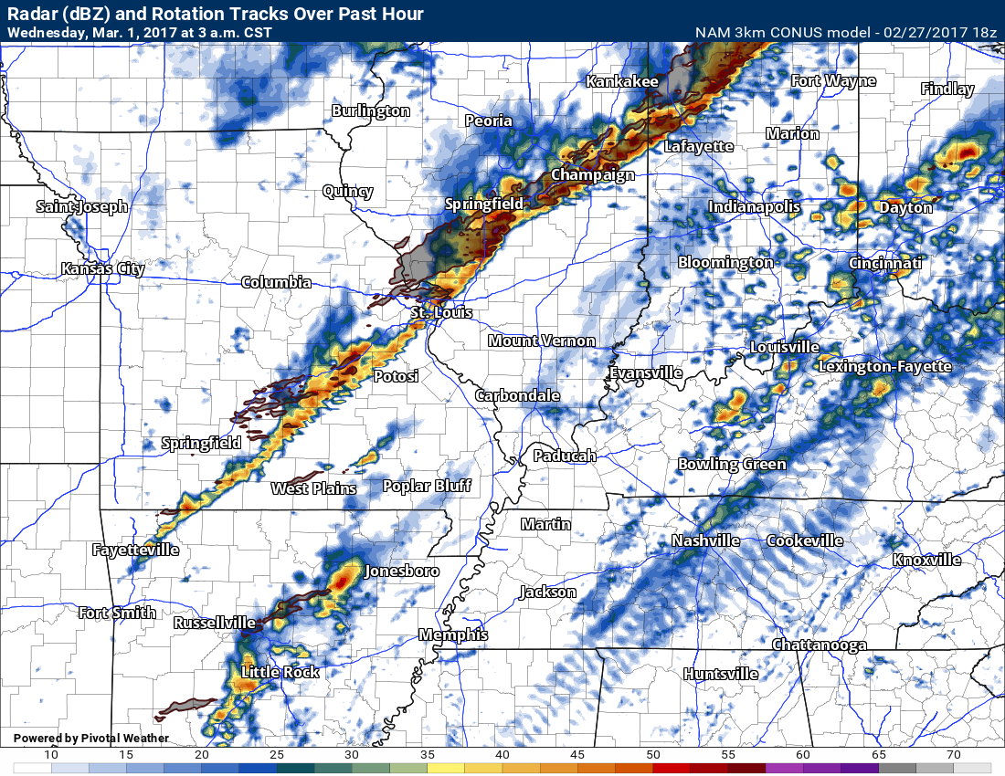
It is possible that portions of the region may not have to deal with stronger storms until after 2 or 3 am. This is especially true over Kentucky and Tennessee. That is one possibility. This will need to be monitored. Timing of storms is a bit uncertain. Hopefully, through the day, I can fine tune that part of the forecast.
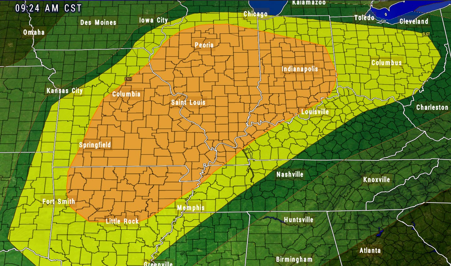
The Storm Prediction Center has the entire region outlined for some storms. Monitor updates throughout the day.
The yellow zone is the slight risk zone. That is where severe storms are likely to occur, but perhaps not widespread.
The orange zone is the enhanced risk. That is the highest risk (so far today) for severe weather. That is where the probabilities favor the most intense weather. Don’t get too hung up on the colors.
The risk covers the entire region.
CAP
The Beau Dodson Weather APP is ready for Apple users (Android is next). The purpose of this APP is for me to deliver your text messages instantly. ATT and Verizon have not always been reliable when it comes to speed. The APP allows instant delivery. You can keep your test messages on and use the APP. You can set the APP to turn off your text messages and just receive them through the APP.
We are working on the Android APP. Hopefully, it will be available in a week or so.
The APP is for subscribers.

The direct download can be viewed here
https://itunes.apple.com/us/app/id1190136514
If you have not signed up for the texting service then you may do so at www.beaudodsonweather.com
If you have not signed up for the texts messages, then please do. Your support helps with all of this

and
