
Click one of the links below to take you directly to that section
![]()
![]()
![]()
![]()
![]()
![]()
![]()
.

.
Seven Day Hazardous Weather Outlook
Facebook Q&A THREAD CLICK HERE

.
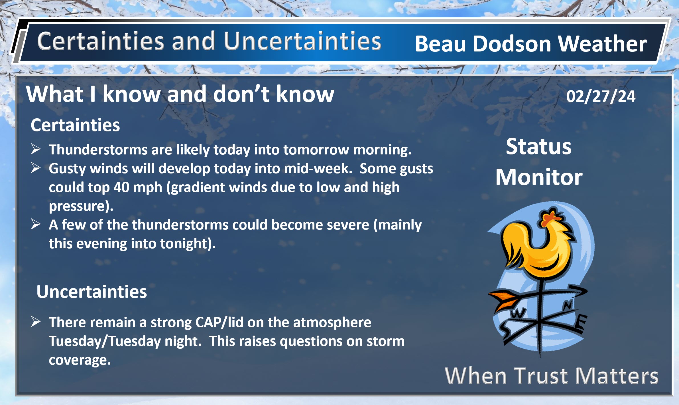
1. Is lightning in the forecast? YES. Lightning is possible today into tomorrow morning. Lightning is possible Sunday night into Monday night.
2. Are severe thunderstorms in the forecast? MONITOR. Some storms could be severe today into tomorrow morning. Another chance of severe weather Sunday night into Monday night.
The concern will be damaging wind and hail. There is a low level tornado risk, as well. The primary time-frame of concern will be tonight into early tomorrow morning.
I will monitor the Sunday night into Monday night threat, as well. Still several days to watch that one.
The Storm Prediction Center has outlined our region for a few severe storms. High wind is the primary concern. Perhaps nickel size hail, as well.
As always, don’t get too caught up in the colors. The atmosphere doesn’t always obey our colors.
The orange zone has a higher chance of severe weather than the yellow and dark green. But, a severe storm is a sever storm. Whether it is in the yellow or dark green doesn’t matter. The light green is where sub-severe storms are possible.
Tuesday
Tornado Risk Zone
Hail Risk Zone. Hatched means very large hail will be possible.
Wind Risk Zone

3. Is flash flooding in the forecast? NOT AT THIS TIME. I will monitor early next week.
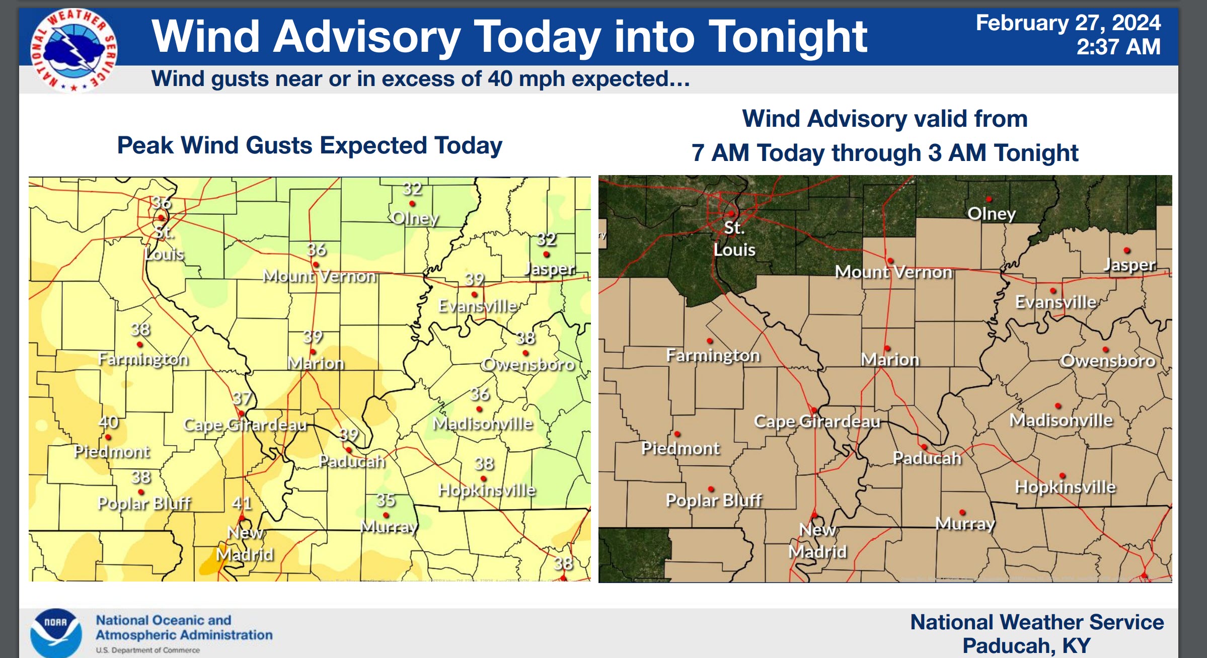
4. Will non-thunderstorm winds top 40 mph? POSSIBLE. Gusty winds are likely today and tonight. Another chance of strong wind gusts next Sunday and Monday.
5. Will the heat index exceed 100 degrees? NO.
6. Will the wind chill dip below 10 degrees? NO.
7. Is measurable snow and/or sleet in the forecast? NO.
8. Is freezing rain/ice in the forecast? NO.
Freezing rain is rain that falls and instantly freezes on objects such as trees and power lines Freezing fog possible, as well.
.

Fire weather risk level.
Tuesday and Tuesday night: 5. Medium risk.
Wednesday: 3. Very Low risk.
Wednesday night: 3. Very Low risk.
Thursday: 4. Low risk.
Fire Weather Discussion
South winds are expected to increase today across the entire area with gusts of 35 to 45 mph during the day. Relative humidity values will stay above 45 to 50 percent except for parts of the Ozark Foothills of southeast Missouri where a dryline may pass far enough east to drop humidity into the 20 to 35 percent range. A red flag warning has been issued for this area with the chances higher the further west you go. Thunderstorms are then forecast tonight ahead of a front that will turn temperatures sharply colder. A moderating trend is then expected through the rest of the week into the weekend.
A Haines Index of 6 means a high potential for an existing fire to become large or exhibit erratic fire behavior, 5 means medium potential, 4 means low potential, and anything less than 4 means very low potential.
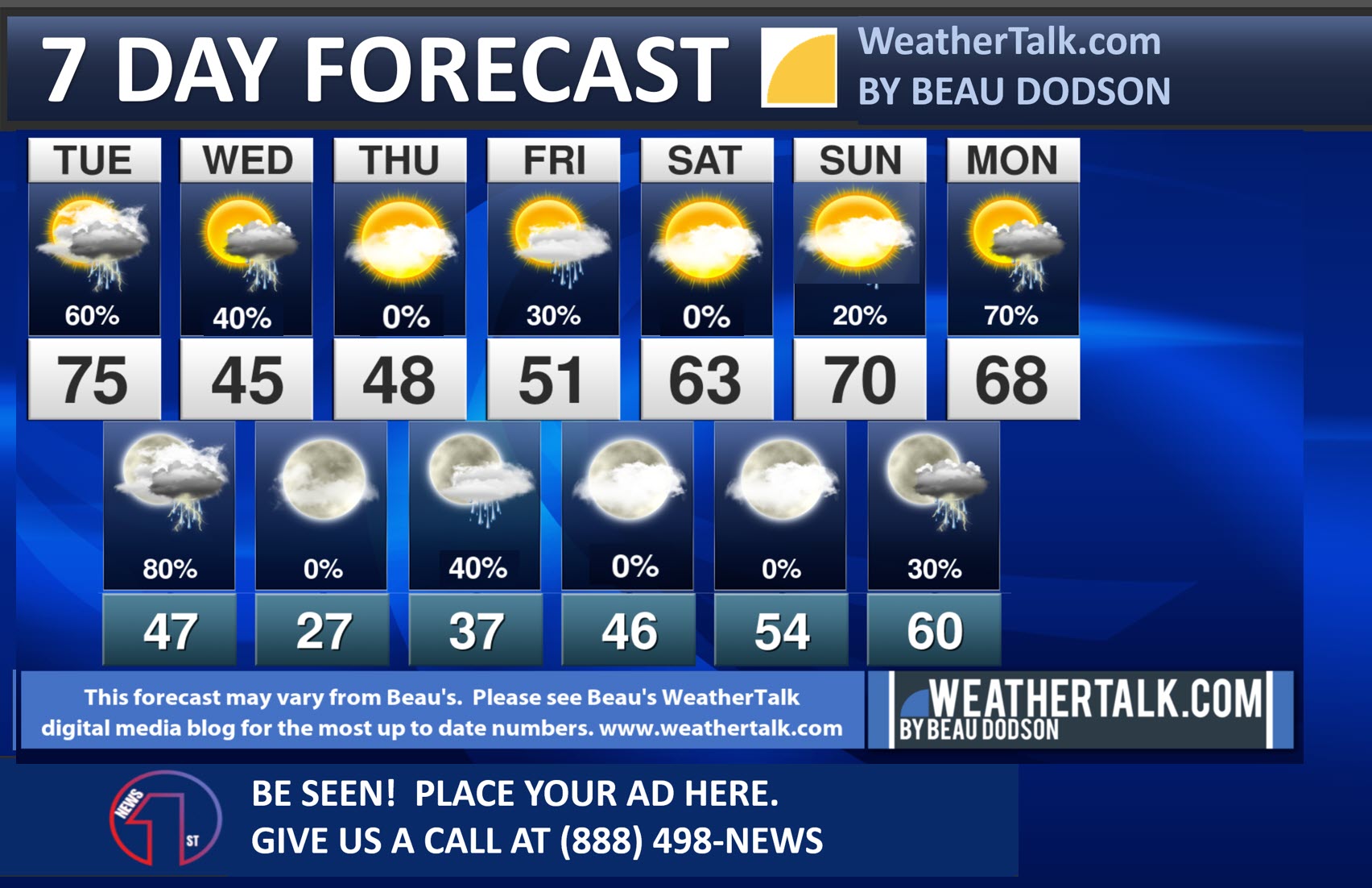
Seven-day forecast for southeast Missouri, southern Illinois, western Kentucky, and western Tennessee.
This is a BLEND for the region. Scroll down to see the region by region forecast.
.

THE FORECAST IS GOING TO VARY FROM LOCATION TO LOCATION. Scroll down to see your local forecast details.
48-hour forecast Graphics


.
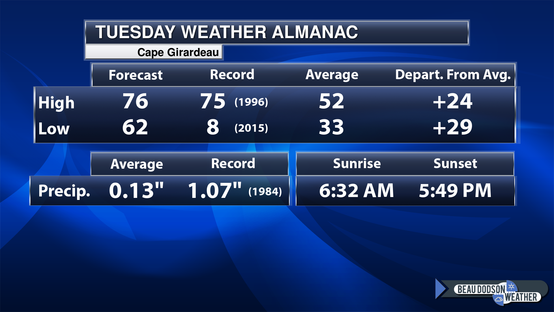
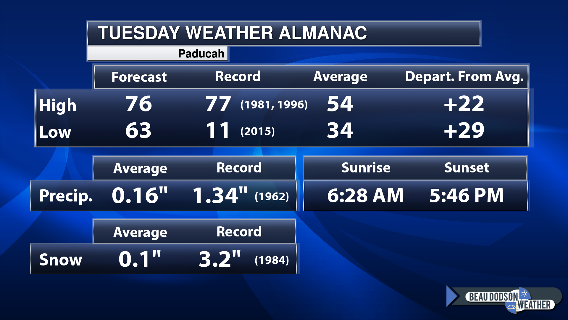
Today’s Local Almanacs (for a few select cities). Your location will be comparable.
Note, the low is this morning’s low and not tomorrows.
The forecast temperature shows you today’s expected high and this morning’s low.
The graphic shows you the record high and record low for today. It shows you what year that occurred, as well.
It then shows you what today’s average temperature is.
It shows you the departures (how may degrees above or below average temperatures will be ).
It shows you the average precipitation for today. Average comes from thirty years of rain totals.
It also shows you the record rainfall for the date and what year that occurred.
The sunrise and sunset are also shown.


![]()
.
.
Tuesday Forecast: A mix of sun and clouds. Very warm. Windy. A chance of mainly morning showers and thunderstorms. There will be a strong CAP/lid on the atmosphere. This could keep thunderstorms from forming until the cold front moves in Tuesday night.
What is the chance of precipitation?
Far northern southeast Missouri ~ 10%
Southeast Missouri ~ 20%
The Missouri Bootheel ~ 30%
I-64 Corridor of southern Illinois ~ 10%
Southern Illinois ~ 20%
Extreme southern Illinois (southern seven counties) ~ 30%
Far western Kentucky (Purchase area) ~ 30%
The Pennyrile area of western KY ~ 30%
Northwest Kentucky (near Indiana border) ~ 20%
Northwest Tennessee ~ 30%
Coverage of precipitation: Widely scattered
Timing of the precipitation: Before 12 PM. Otherwise, very low chances the rest of the day.
Far northern southeast Missouri ~ 76° to 82°
Southeast Missouri ~ 76° to 78°
The Missouri Bootheel ~ 76° to 78°
I-64 Corridor of southern Illinois ~ 74° to 78°
Southern Illinois ~ 74° to 78°
Extreme southern Illinois (southern seven counties) ~ 74° to 78°
Far western Kentucky ~ 74° to 78°
The Pennyrile area of western KY ~ 74° to 78°
Northwest Kentucky (near Indiana border) ~ 74° to 78°
Northwest Tennessee ~ 74° to 78°
Winds will be from this direction: South southwest 15 to 35 mph. Gusty.
Wind chill or heat index (feels like) temperature forecast: 70° to 78°
What impacts are anticipated from the weather? Wet roadways. Lightning. Monitor the risk of intense thunderstorms late in the day.
Should I cancel my outdoor plans? No, but monitor the Beau Dodson Weather Radars.
UV Index: 2. Low.
Sunrise: 6:29 AM
Sunset: 5:47 PM .
.
Tuesday Night Forecast: Mostly cloudy. A line of showers and thunderstorms developing late at night. Moving in from the west northwest. A few intense storms are possible with gusty wind and hail. Lightning, as well. Supercells could form ahead of the line this evening into the overnight hours, as well. If supercells form, then they could produce very large hail. A tornado can’t be ruled out, as well. Stay weather aware.
What is the chance of precipitation?
Far northern southeast Missouri ~ 70%
Southeast Missouri ~ 70%
The Missouri Bootheel ~ 70%
I-64 Corridor of southern Illinois ~ 80%
Southern Illinois ~ 80%
Extreme southern Illinois (southern seven counties) ~ 80%
Far western Kentucky (Purchase area) ~ 80%
The Pennyrile area of western KY ~ 70%
Northwest Kentucky (near Indiana border) ~ 70%
Northwest Tennessee ~ 70%
Coverage of precipitation: Becoming numerous late at night. A line of storms.
Timing of the precipitation: Any given point of time.
Temperature range:
Far northern southeast Missouri ~ 28° to 32°
Southeast Missouri ~ 33° to 36°
The Missouri Bootheel ~ 38° to 42°
I-64 Corridor of southern Illinois ~ 32° to 35°
Southern Illinois ~ 33° to 36°
Extreme southern Illinois (southern seven counties) ~ 34° to 38°
Far western Kentucky ~ 34° to 38°
The Pennyrile area of western KY ~ 40° to 44°
Northwest Kentucky (near Indiana border) ~ 40° to 42°
Northwest Tennessee ~ 43° to 46°
Winds will be from this direction: South southwest 15 to 35 mph. Gusty. Becoming west northwest behind the cold front.
Wind chill or heat index (feels like) temperature forecast: 24° to 42°
What impacts are anticipated from the weather? Wet roadways. Lightning. A few storms could be severe.
Should I cancel my outdoor plans? Have a plan B. Monitor the threat of thunderstorms. Stay weather aware.
Moonrise: 8:54 PM
Moonset: 7:57 AM
The phase of the moon: Waning Gibbous
.
Wednesday Forecast: Mostly cloudy early. Some clearing. A chance of mainly morning showers and thunderstorms. Turning colder. Falling temperatures.
What is the chance of precipitation?
Far northern southeast Missouri ~ 10%
Southeast Missouri ~ 10%
The Missouri Bootheel ~ 20%
I-64 Corridor of southern Illinois ~ 20%
Southern Illinois ~ 30%
Extreme southern Illinois (southern seven counties) ~ 30%
Far western Kentucky (Purchase area) ~ 40%
The Pennyrile area of western KY ~ 60%
Northwest Kentucky (near Indiana border) ~ 60%
Northwest Tennessee ~ 60%
Coverage of precipitation: Ending west to east.
Timing of the precipitation: Mostly before noon.
Far northern southeast Missouri ~ 40° to 44°
Southeast Missouri ~ 42° to 44°
The Missouri Bootheel ~ 42° to 44°
I-64 Corridor of southern Illinois ~ 42° to 44°
Southern Illinois ~ 42° to 45°
Extreme southern Illinois (southern seven counties) ~ 42° to 45°
Far western Kentucky ~ 42° to 45°
The Pennyrile area of western KY ~ 42° to 45°
Northwest Kentucky (near Indiana border) ~ 42° to 44°
Northwest Tennessee ~ 42° to 45°
Winds will be from this direction: Southwest becoming west northwest at 15 to 35 mph.
Wind chill or heat index (feels like) temperature forecast: 32° to 58°
What impacts are anticipated from the weather? Wet roadways. Lightning. A few of the morning storms could be intense.
Should I cancel my outdoor plans? Have a plan B early in the day over KY/TN. The rest of the area may be mostly dry by morning as storms move off to the east southeast.
UV Index: 3. Moderate.
Sunrise: 6:28 AM
Sunset: 5:48 PM .
.
Wednesday Night Forecast: Decreasing clouds.
What is the chance of precipitation?
Far northern southeast Missouri ~ 0%
Southeast Missouri ~ 0%
The Missouri Bootheel ~ 0%
I-64 Corridor of southern Illinois ~ 0%
Southern Illinois ~ 0%
Extreme southern Illinois (southern seven counties) ~ 0%
Far western Kentucky (Purchase area) ~ 0%
The Pennyrile area of western KY ~ 0%
Northwest Kentucky (near Indiana border) ~ 0%
Northwest Tennessee ~ 0%
Coverage of precipitation:
Timing of the precipitation:
Temperature range:
Far northern southeast Missouri ~ 18° to 22°
Southeast Missouri ~ 20° to 22°
The Missouri Bootheel ~ 22° to 24°
I-64 Corridor of southern Illinois ~ 20° to 22°
Southern Illinois ~ 22° to 24°
Extreme southern Illinois (southern seven counties) ~ 23° to 26°
Far western Kentucky ~ 23° to 26°
The Pennyrile area of western KY ~ 23° to 26°
Northwest Kentucky (near Indiana border) ~ 23° to 26°
Northwest Tennessee ~ 23° to 26°
Winds will be from this direction: Northwest 10 to 20 mph. Gusty.
Wind chill or heat index (feels like) temperature forecast: 15° to 25°
What impacts are anticipated from the weather? Cold.
Should I cancel my outdoor plans?
Moonrise: 9:53 PM
Moonset: 8:19 AM
The phase of the moon: Waning Gibbous
.
Thursday Forecast: Mostly sunny early in the day. Becoming partly cloudy.
What is the chance of precipitation?
Far northern southeast Missouri ~ 0%
Southeast Missouri ~ 0%
The Missouri Bootheel ~ 0%
I-64 Corridor of southern Illinois ~ 0%
Southern Illinois ~ 0%
Extreme southern Illinois (southern seven counties) ~ 0%
Far western Kentucky (Purchase area) ~ 0%
The Pennyrile area of western KY ~ 0%
Northwest Kentucky (near Indiana border) ~ 0%
Northwest Tennessee ~0%
Coverage of precipitation:
Timing of the precipitation:
Far northern southeast Missouri ~ 44° to 48°
Southeast Missouri ~ 44° to 48°
The Missouri Bootheel ~ 48° to 50°
I-64 Corridor of southern Illinois ~ 44° to 48°
Southern Illinois ~ 48° to 50°
Extreme southern Illinois (southern seven counties) ~ 48° to 50°
Far western Kentucky ~ 48° to 50°
The Pennyrile area of western KY ~ 48° to 50°
Northwest Kentucky (near Indiana border) ~ 48° to 50°
Northwest Tennessee ~ 48° to 50°
Winds will be from this direction: Southeast 6 to 12 mph.
Wind chill or heat index (feels like) temperature forecast: 38° to 46°
What impacts are anticipated from the weather?
Should I cancel my outdoor plans? No
UV Index: 3. Moderate.
Sunrise: 6:27 AM
Sunset: 5:49 PM .
.
Thursday Night Forecast: Thickening clouds. A chance of showers.
What is the chance of precipitation?
Far northern southeast Missouri ~ 20%
Southeast Missouri ~ 20%
The Missouri Bootheel ~ 40%
I-64 Corridor of southern Illinois ~ 20%
Southern Illinois ~ 20%
Extreme southern Illinois (southern seven counties) ~ 40%
Far western Kentucky (Purchase area) ~ 40%
The Pennyrile area of western KY ~ 40%
Northwest Kentucky (near Indiana border) ~ 40%
Northwest Tennessee ~ 40%
Coverage of precipitation: Scattered
Timing of the precipitation: After 6 PM
Temperature range:
Far northern southeast Missouri ~ 32° to 34°
Southeast Missouri ~ 33° to 35°
The Missouri Bootheel ~ 33° to 35°
I-64 Corridor of southern Illinois ~ 33° to 35°
Southern Illinois ~ 33° to 36°
Extreme southern Illinois (southern seven counties) ~ 33° to 36°
Far western Kentucky ~33° to 35°
The Pennyrile area of western KY ~ 34° to 38°
Northwest Kentucky (near Indiana border) ~ 33° to 35°
Northwest Tennessee ~ 34° to 38°
Winds will be from this direction: South southeast 7 to 14 mph.
Wind chill or heat index (feels like) temperature forecast: 30° to 34°
What impacts are anticipated from the weather? Wet roadways.
Should I cancel my outdoor plans? No, but check the radars.
Moonrise: 10:54PM
Moonset: 8:43 AM
The phase of the moon: Waning Gibbous
.
Friday Forecast: Mostly cloudy early. A chance of early morning showers. Becoming partly sunny.
What is the chance of precipitation?
Far northern southeast Missouri ~ 20%
Southeast Missouri ~ 20%
The Missouri Bootheel ~ 30%
I-64 Corridor of southern Illinois ~ 20%
Southern Illinois ~ 20%
Extreme southern Illinois (southern seven counties) ~ 30%
Far western Kentucky (Purchase area) ~ 30%
The Pennyrile area of western KY ~ 30%
Northwest Kentucky (near Indiana border) ~ 30%
Northwest Tennessee ~ 30%
Coverage of precipitation: Scattered
Timing of the precipitation: Any given point of time.
Far northern southeast Missouri ~ 50° to 52°
Southeast Missouri ~ 52° to 54°
The Missouri Bootheel ~ 53° to 56°
I-64 Corridor of southern Illinois ~ 50° to 52°
Southern Illinois ~ 52° to 54°
Extreme southern Illinois (southern seven counties) ~ 52° to 54°
Far western Kentucky ~ 52° to 54°
The Pennyrile area of western KY ~ 52° to 55°
Northwest Kentucky (near Indiana border) ~ 52° to 55°
Northwest Tennessee ~ 52° to 55°
Winds will be from this direction:
Wind chill or heat index (feels like) temperature forecast: 48° to 58°
What impacts are anticipated from the weather? Wet roadways.
Should I cancel my outdoor plans? No, but monitor updates.
UV Index: 3. Moderate.
Sunrise: 6:25AM
Sunset: 5:50 PM .
.
Friday Night Forecast: Decreasing clouds. Any remaining showers will end.
What is the chance of precipitation?
Far northern southeast Missouri ~ 0%
Southeast Missouri ~ 0%
The Missouri Bootheel ~ 0%
I-64 Corridor of southern Illinois ~ 0%
Southern Illinois ~ 20%
Extreme southern Illinois (southern seven counties) ~ 20%
Far western Kentucky (Purchase area) ~ 20%
The Pennyrile area of western KY ~ 20%
Northwest Kentucky (near Indiana border) ~ 30%
Northwest Tennessee ~ 20%
Coverage of precipitation: Widely scattered
Timing of the precipitation: Before midnight
Temperature range:
Far northern southeast Missouri ~ 40° to 44°
Southeast Missouri ~ 40° to 44°
The Missouri Bootheel ~ 43° to 46°
I-64 Corridor of southern Illinois ~ 40° to 44°
Southern Illinois ~ 40° to 44°
Extreme southern Illinois (southern seven counties) ~ 43° to 46°
Far western Kentucky ~ 43° to 46°
The Pennyrile area of western KY ~ 43° to 46°
Northwest Kentucky (near Indiana border) ~ 43° to 46°
Northwest Tennessee ~ 43° to 46°
Winds will be from this direction: South southeast at 7 to 14 mph. Becoming W SW.
Wind chill or heat index (feels like) temperature forecast: 38° to 42°
What impacts are anticipated from the weather?
Should I cancel my outdoor plans?
Moonrise: 11:58PM
Moonset: 9:10 AM
The phase of the moon: Waning Gibbous
.
Click here if you would like to return to the top of the page.

-
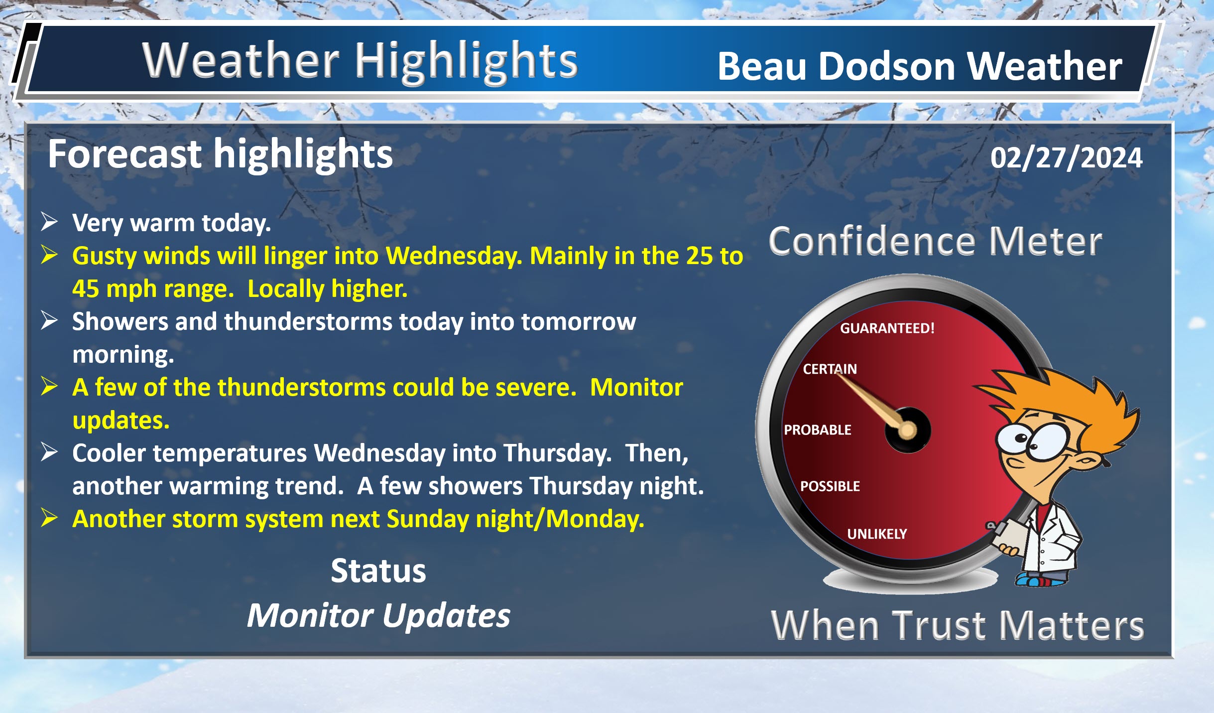
- Very warm today.
- Gusty winds today. Occasional gusts above 40 mph likely.
- A few thunderstorms this morning. Ending. Then, a lull.
- Additional storms will form this evening and tonight. Perhaps some supercells. A line of storms will eventually form along the front.
- Turning colder Wednesday with rapidly falling temperatures on gusty northwest winds. Rain could end as rain/snow mix with no accumulation.
- Warming trend begins Friday into the weekend.
- A few showers Thursday night/Friday morning. Nothing major.
- Another big storm system next week. Monitor updates.
Weather advice:
Do you have any suggestions or comments? Email me at beaudodson@usawx.com
Make sure you have three to five ways of receiving your severe weather information.
Beau’s Forecast Discussion
A stormy 24 hours ahead of us.
First, look at how mild it is this morning. Just crazy mild for February. This would be mild for daytime highs, let alone morning lows.
Double click images to enlarge them.
We do have a few storms on radar this morning, but those will quickly push off to the east.
That will leave most of today dry and very warm. Highs will top out in the 74 to 78 degree range with pockets of greater than 78 degrees.
This is WELL above average.
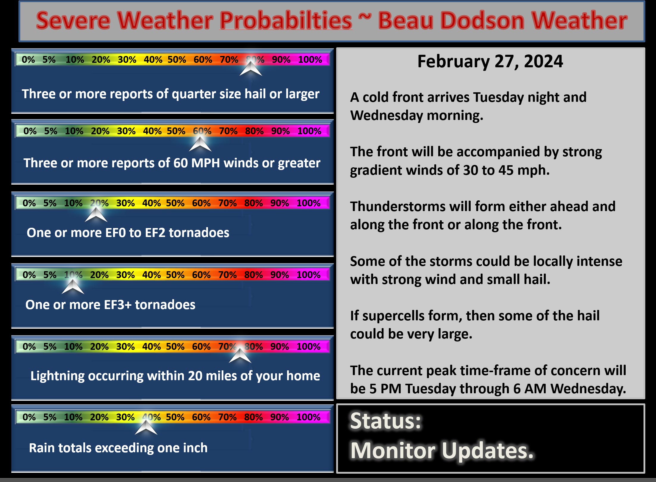
A strong cold front will push into the region this evening. I will be watching to see if supercells form along or ahead of the cold front.
A very strong CAP will blanket the region. A CAP keeps air parcels from rising. To form thunderstorms, you need air parcels to rise.
If the CAP does break, then supercells and a line of thunderstorms will form.
This would most likely occur between 4 PM and 12 AM. The supercell threat appears to be the first half of the event, then a line of thunderstorms will form.
The atmosphere will be very unstable. Wind shear will be enough to produce turning winds throughout the atmosphere. This could lead to a few reports of golf ball size hail, 60+ mph wind gusts, and even a tornado. I can’t rule out a strong tornado. Stay tuned.
Stay alert and monitor your Beau Dodson Weather App.
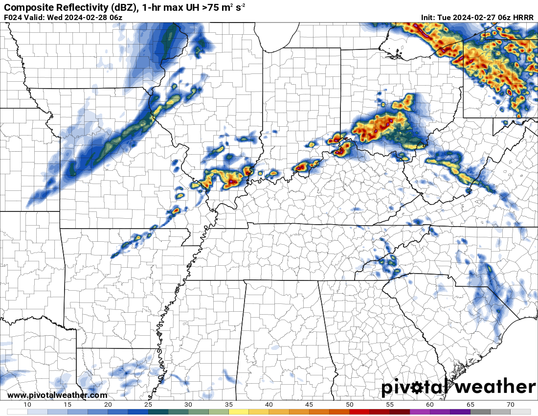
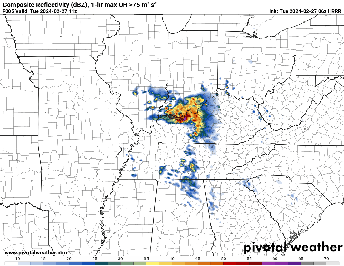
The Hrrr high res model shows a supercell forming around 3 to 5 pm in southern Illinois. Just one model’s opinion, but I will be watching.
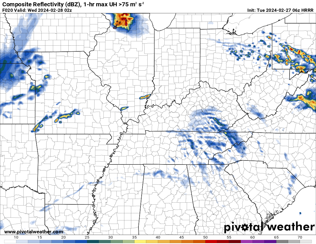
9 PM supercells on the Hrrr model.
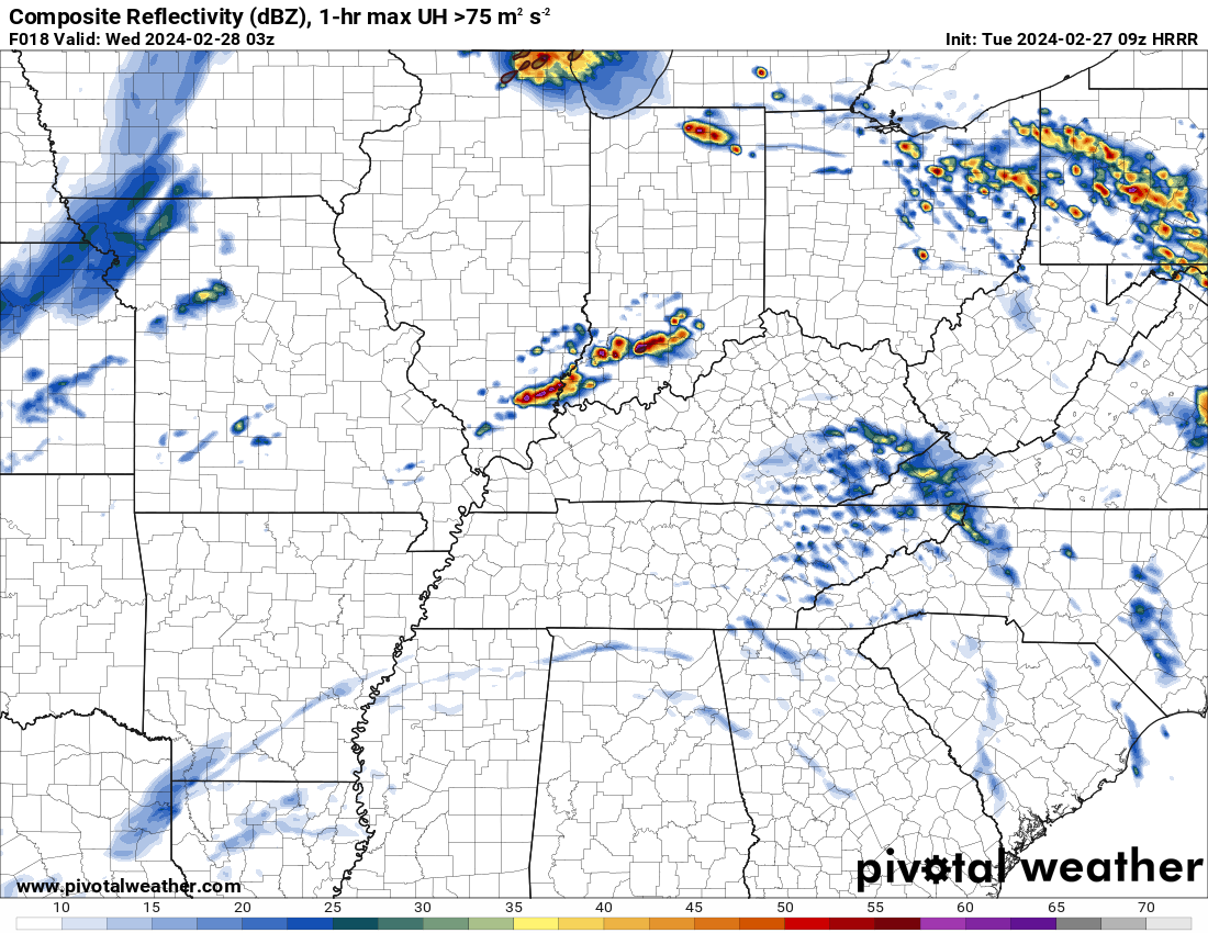
It shows more supercells at midnight. Something to closely monitor this evening and tonight. It will be a long night for forecasters.
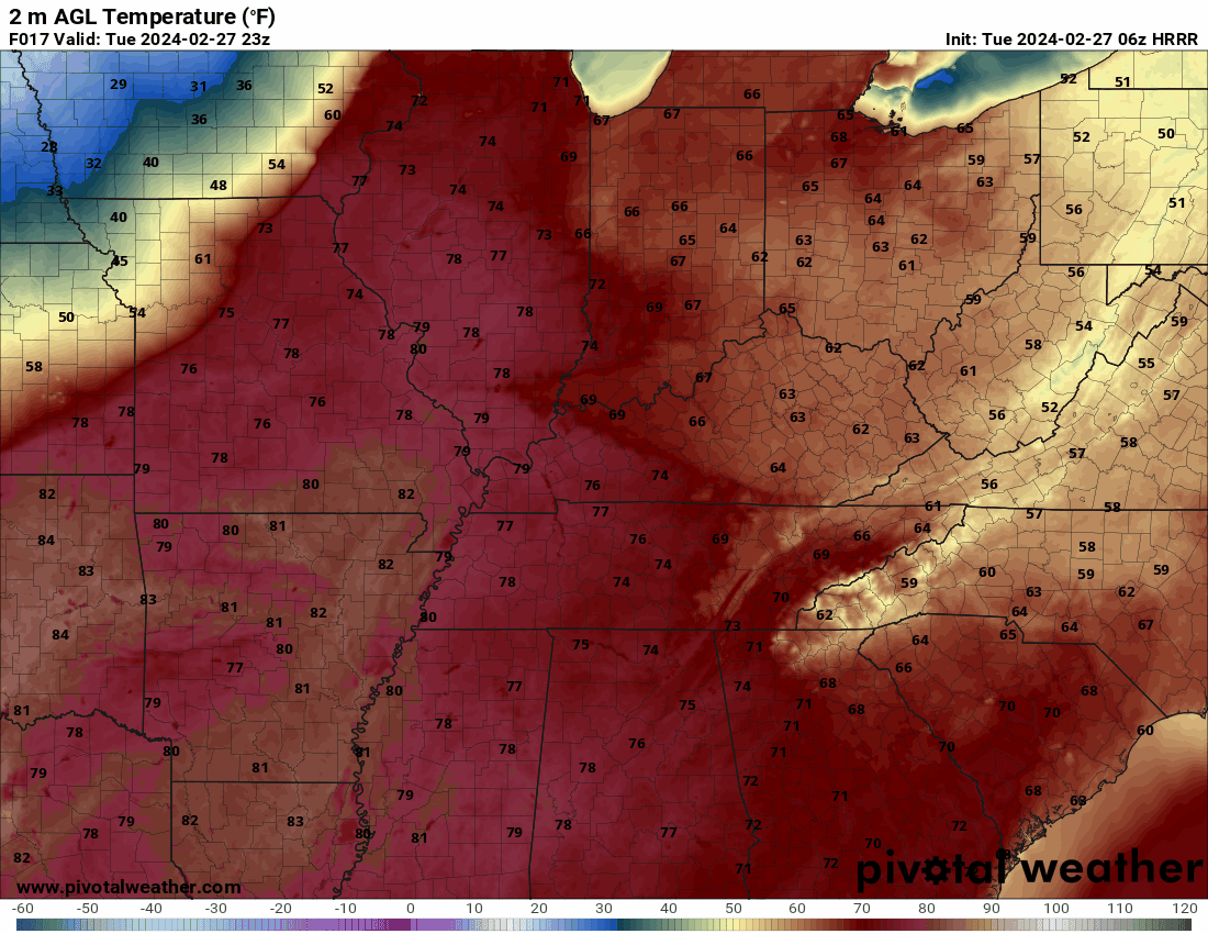
It will turn colder behind the cold front late tonight into tomorrow. Gusty northwest winds will develop behind the front. It will feel like winter tomorrow and tomorrow night. Thursday will be cooler, as well.
Here is the Hrrr model temperature forecast. You can see the rapidly falling temperatures behind the cold front.
Time is in Zulu. 00z=6 pm. 12z=6 am. 18z=12 pm.
Double click images to enlarge them.

A fast moving weak system will bring showers back to the forecast Thursday night and Friday morning. Rain totals will be light.
We begin to warm up as early as Friday and Saturday. Highs will again approach 70 degrees by late in the weekend.
Yet another storm system will bring thunderstorms back to the area next Sunday night and Monday. Some could be intense.
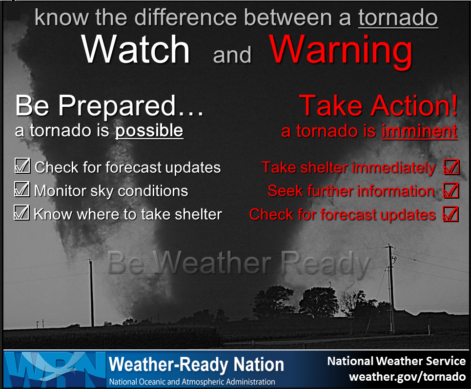
Remember, a warning is more serious than a watch.
![]()
.
Click here if you would like to return to the top of the page.
This outlook covers southeast Missouri, southern Illinois, western Kentucky, and far northwest Tennessee.

.
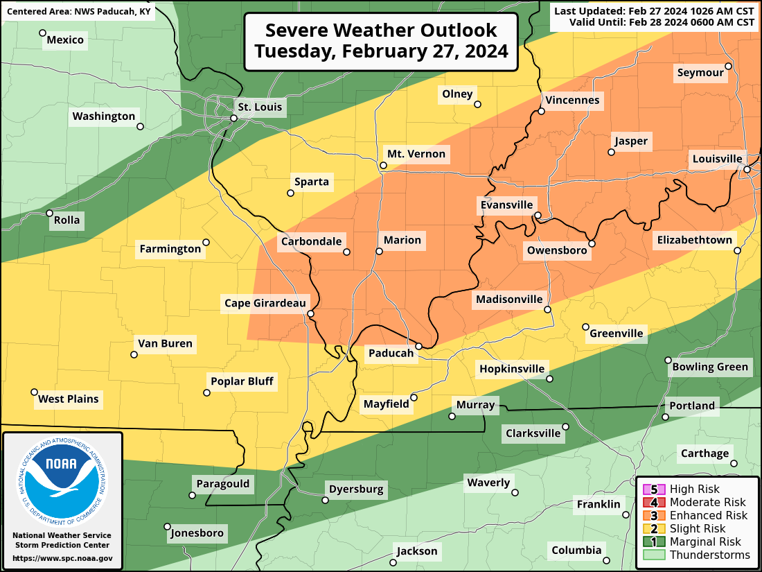
Today’s Storm Prediction Center’s Severe Weather Outlook
Light green is where thunderstorms may occur but should be below severe levels.
Dark green is a level one risk. Yellow is a level two risk. Orange is a level three (enhanced) risk. Red is a level four (moderate) risk. Pink is a level five (high) risk.
One is the lowest risk. Five is the highest risk.
A severe storm is one that produces 58 mph wind or higher, quarter size hail, and/or a tornado.
Explanation of tables. Click here.

.
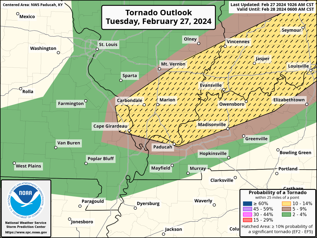
Tornado Probability Outlook

.
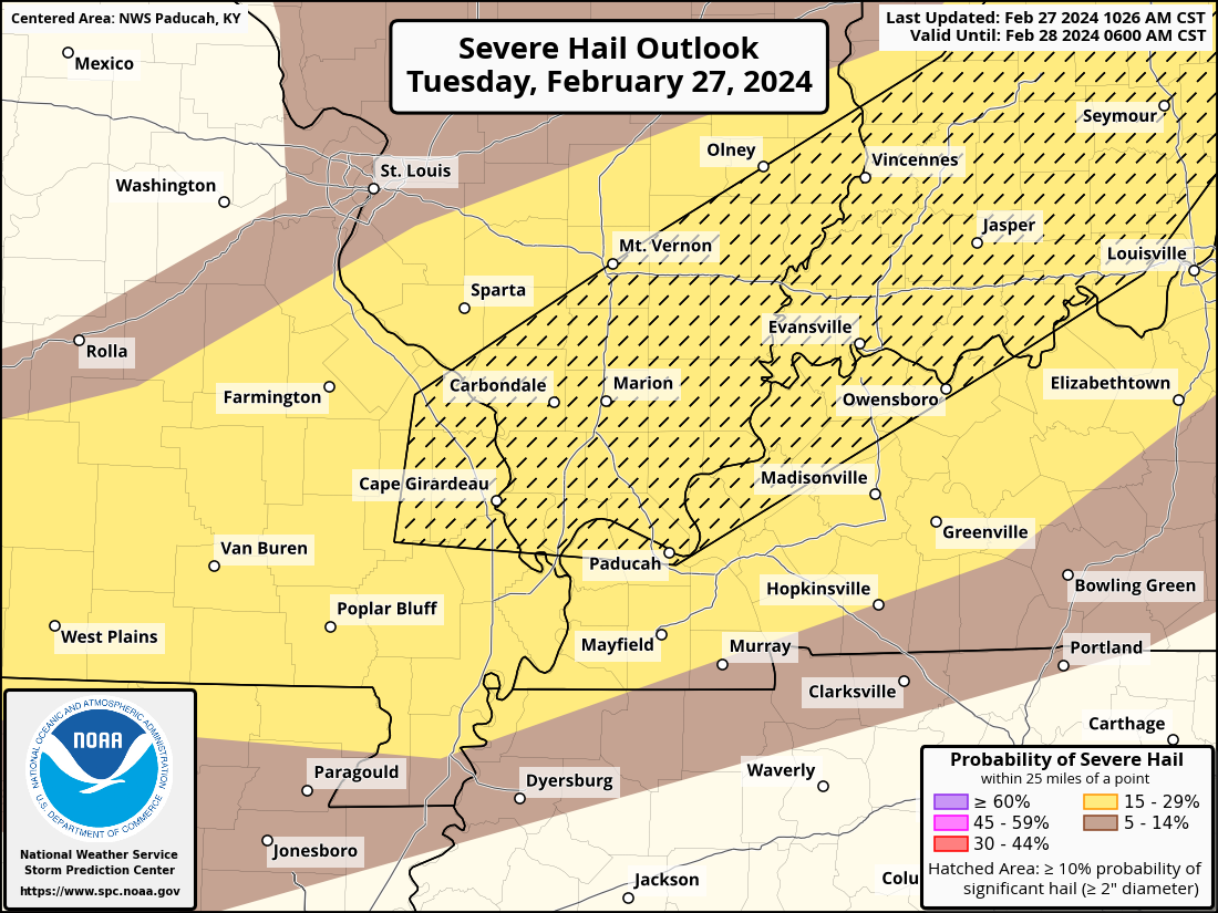
Large Hail Probability Outlook

.
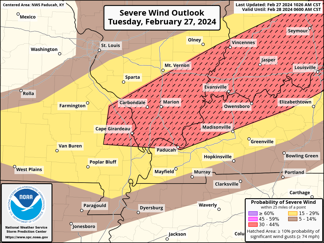
High wind Probability Outlook

.
Tomorrow’s severe weather outlook.

.
Day Three Severe Weather Outlook

.

.
The images below are from NOAA’s Weather Prediction Center.
24-hour precipitation outlook..
 .
.
.
48-hour precipitation outlook.
. .
.
![]()
_______________________________________
.

Click here if you would like to return to the top of the page.
Again, as a reminder, these are models. They are never 100% accurate. Take the general idea from them.
What should I take from these?
- The general idea and not specifics. Models usually do well with the generalities.
- The time-stamp is located in the upper left corner.
.
What am I looking at?
You are looking at computer model data. Meteorologists use many different models to forecast the weather.
Occasionally, these maps are in Zulu time. 12z=7 AM. 18z=1 PM. 00z=7 PM. 06z=1 AM
Green represents light rain. Dark green represents moderate rain. Yellow and orange represent heavier rain.
.
This animation is the HRRR Model.
Occasionally, these maps are in Zulu time. 12z=6 AM. 18z=12 PM. 00z=6 PM. 06z=12 AM
Double click images to enlarge them. Blue is snow. Pink is a wintry mix. Green is rain.
.
This animation is the NAM 3Z Model.
Occasionally, these maps are in Zulu time. 12z=6 AM. 18z=12 PM. 00z=6 PM. 06z=12 AM
Double click images to enlarge them.
.
This animation is the GFS Model.
Green is rain. Yellow and orange are heavier rain. Pink is a wintry mix. Blue is snow. Dark blue is heavier snow.
Occasionally, these maps are in Zulu time. 12z=6 AM. 18z=12 PM. 00z=6 PM. 06z=12 AM
Double click images to enlarge them.
.
This animation is the EC Model.
Green is rain. Yellow and orange are heavier rain. Pink is a wintry mix. Blue is snow. Dark blue is heavier snow.
Occasionally, these maps are in Zulu time. 12z=6 AM. 18z=12 PM. 00z=6 PM. 06z=12 AM
Double click images to enlarge them.
..![]()

.
Click here if you would like to return to the top of the page.
.Average high temperatures for this time of the year are around 51 degrees.
Average low temperatures for this time of the year are around 31 degrees.
Average precipitation during this time period ranges from 0.50″ to 1.00″
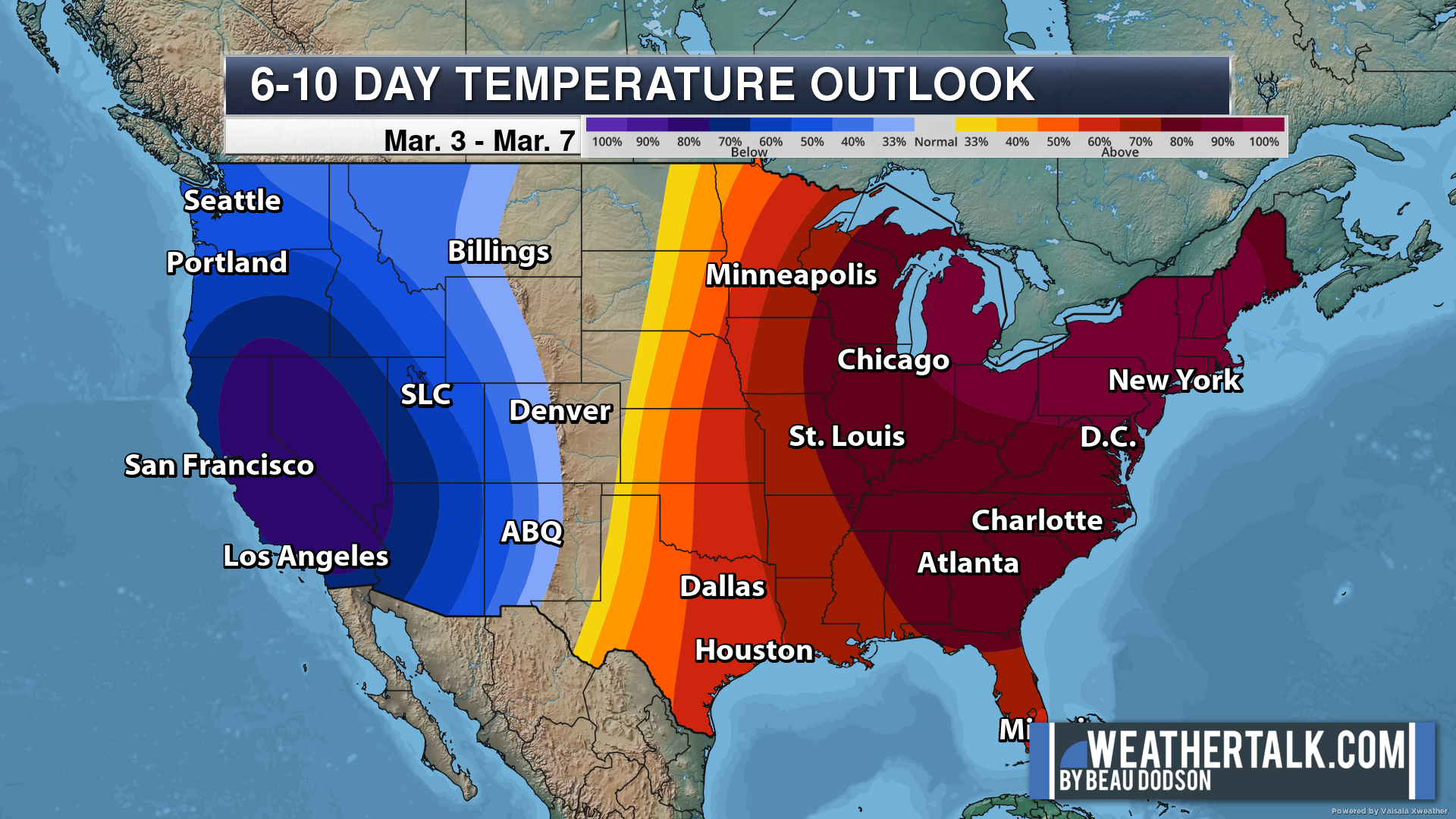
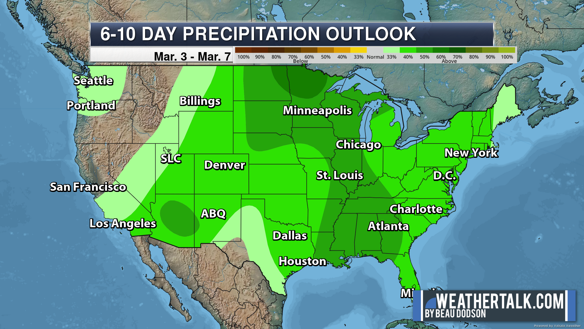
Six to Ten Day Outlook.
Blue is below average. Red is above average. The no color zone represents equal chances.
Average highs for this time of the year are in the lower 60s. Average lows for this time of the year are in the lower 40s.
Green is above average precipitation. Yellow and brown favors below average precipitation. Average precipitation for this time of the year is around one inch per week.
.

Average low temperatures for this time of the year are around 32 degrees.
Average precipitation during this time period ranges from 0.50″ to 1.00″
.
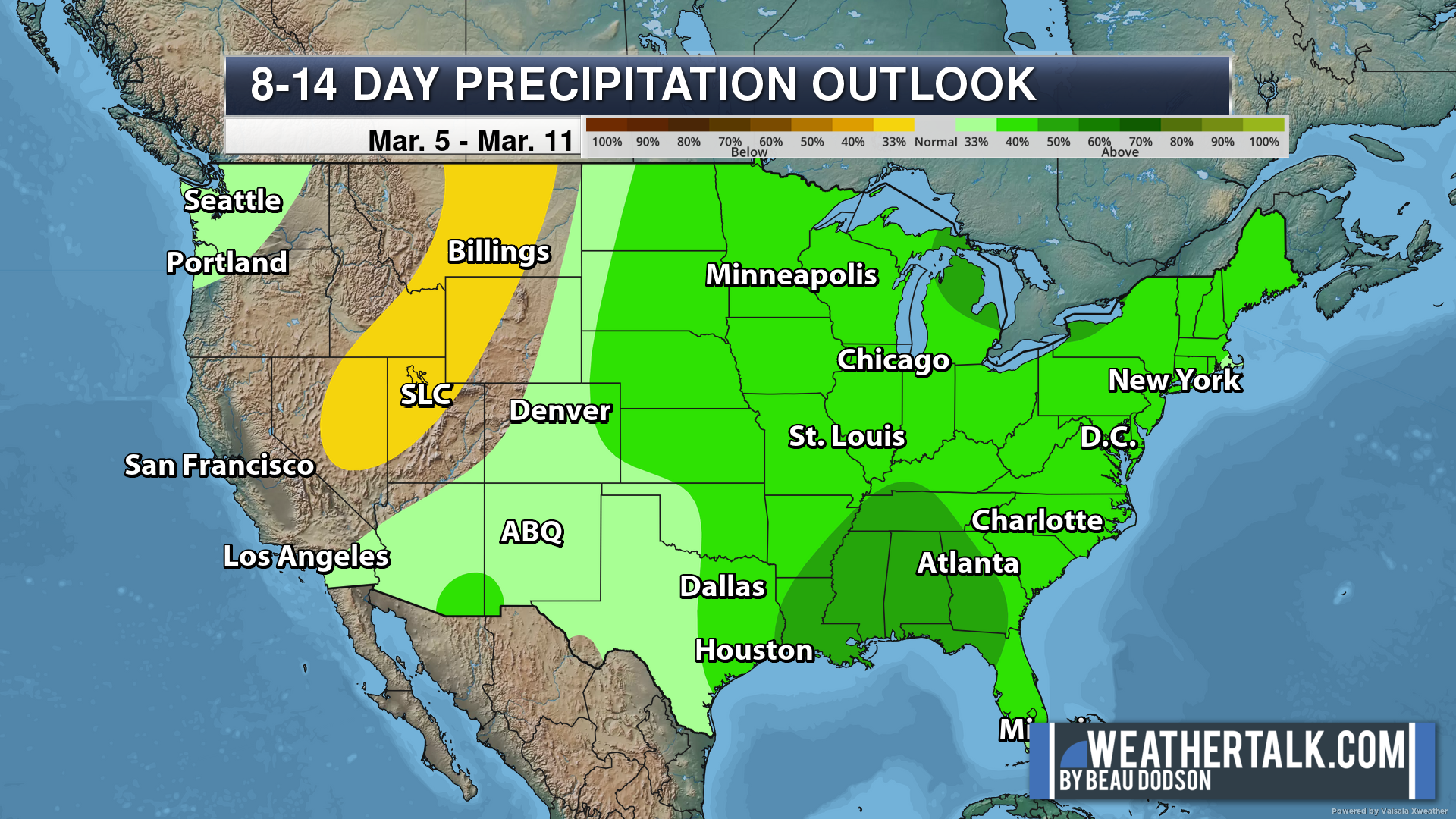
Eight to Fourteen Day Outlook.
Blue is below average. Red is above average. The no color zone represents equal chances.
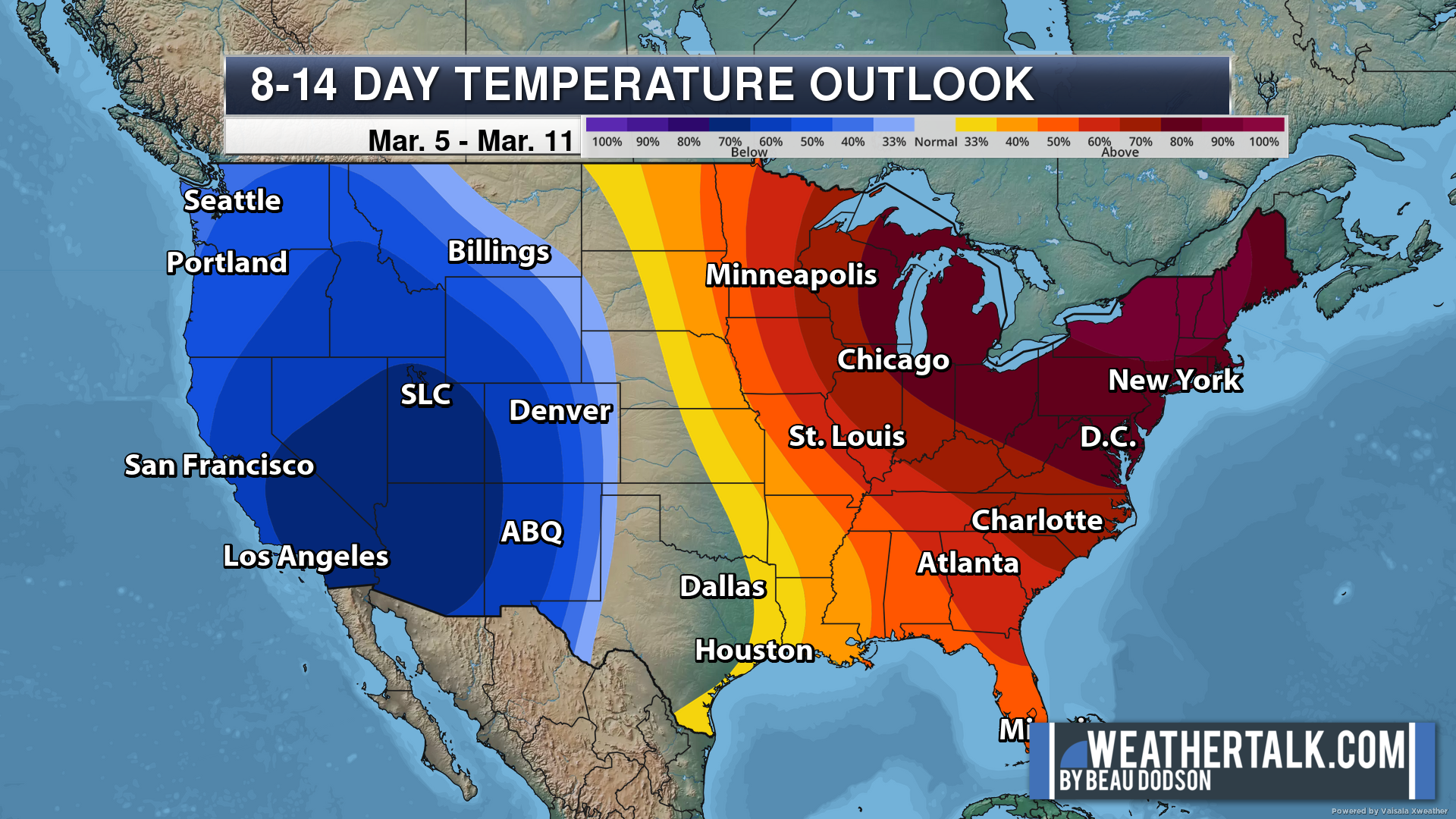
Green is above average precipitation. Yellow and brown favors below average precipitation. Average precipitation for this time of the year is around one inch per week.
.
![]()
The app is for subscribers. Subscribe at www.weathertalk.com/welcome then go to your app store and search for WeatherTalk
Subscribers, PLEASE USE THE APP. ATT and Verizon are not reliable during severe weather. They are delaying text messages.
The app is under WeatherTalk in the app store.

Apple users click here

Android users click here
.

Radars and Lightning Data
Interactive-city-view radars. Clickable watches and warnings.
https://wtalk.co/B3XHASFZ
If the radar is not updating then try another one. If a radar does not appear to be refreshing then hit Ctrl F5. You may also try restarting your browser.
Backup radar site in case the above one is not working.
https://weathertalk.com/morani
Regional Radar
https://imagery.weathertalk.com/prx/RadarLoop.mp4
** NEW ** Zoom radar with chaser tracking abilities!
ZoomRadar
Lightning Data (zoom in and out of your local area)
https://wtalk.co/WJ3SN5UZ
Not working? Email me at beaudodson@usawx.com
National map of weather watches and warnings. Click here.
Storm Prediction Center. Click here.
Weather Prediction Center. Click here.
.

Live lightning data: Click here.
Real time lightning data (another one) https://map.blitzortung.org/#5.02/37.95/-86.99
Our new Zoom radar with storm chases
.
.

Interactive GOES R satellite. Track clouds. Click here.
GOES 16 slider tool. Click here.
College of DuPage satellites. Click here
.

Here are the latest local river stage forecast numbers Click Here.
Here are the latest lake stage forecast numbers for Kentucky Lake and Lake Barkley Click Here.
.
.
Find Beau on Facebook! Click the banner.


 .
.