Are you in need of new eye glasses? New contacts? Perhaps you need an eye exam. Then be sure and visit the Eye Care Associates of western Kentucky (the Paducah location). For all of your families eye care needs.
Visit their web-site here. Or, you can also visit their Facebook page.
Best at Enabling Body Shop Profitability since 1996. Located In Paducah Kentucky and Evansville Indiana; serving all customers in between. They provide Customer Service, along with all the tools necessary for body shops to remain educated and competitive. Click the logo above for their main web-site.
You can find McClintock Preferred Finishes on Facebook, as well
Expressway Carwash and Express Lube are a locally owned and operated full-service Carwash and Lube established in 1987.
They have been proudly serving the community for 29 years now at their Park Avenue location and 20 years at their Southside location. They have been lucky enough to partner with Sidecar Deli in 2015, which allows them to provide their customers with not only quality service, but quality food as well.
If you haven’t already, be sure to make Expressway your one-stop shop, with their carwash, lube and deli. For hours of operation and pricing visit www.expresswashlube.com or Expressway Carwash on Facebook.
The quad states area source for Precision Ag Technology. Locally owned and operated, specializing in planting, harvesting, fertilizer application and drainage. Visit them on their website and on Facebook. You can also find them on Twitter. They are located in Almo, Kentucky. Phone 270-718-0245

Facebook update Q&A thread Link Click here
1. Make sure your weather radios are in working order.
2. Make sure you have turned on WeatherOne in your text message service. That is the first text message option and is the one I use to send you tornado alerts. Sign up at www.Beaudodsonweather.com
3. Monitor updated forecast, because confidence on what happens Tuesday night and Wednesday morning is low.
Video update
Click the YouTube logo to watch in full screen mode
Facebook update/Questions and answers
Click here for Q an A Facebook link
Tonight
Thunderstorms are possible tonight after midnight. Some of the storms could produce dime to nickel size hail.
Severe weather, outside of hail, is not anticipated. In other words, I am not concerned about tornadoes or damaging winds tonight into early Tuesday morning.
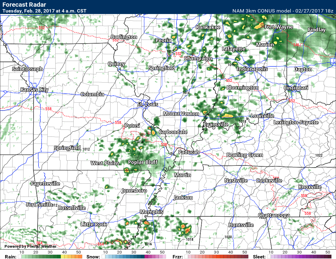
Here is a future-cast radar shot for 4 am Tuesday morning
As you can see, scattered storms in the area with lightning and possibly some hail.
This won’t be exact. This is a computer model. You get the general idea. Spotty storms will be possible across the entire region. It is even possible a cluster of storms form.
Tuesday
Morning storms should come to an end. Again, small hail possible.
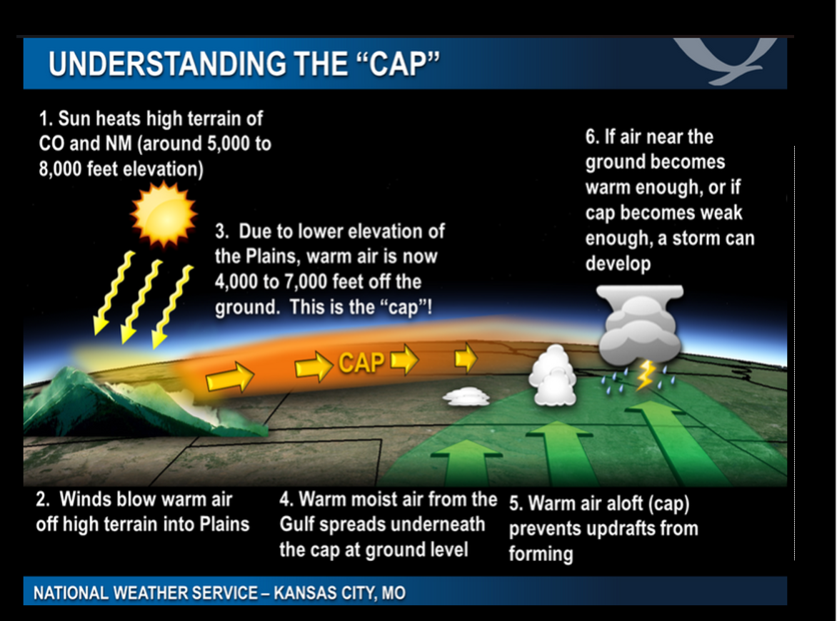
We should be capped on Tuesday afternoon. A CAP (see graphic below) is when warm air aloft prevents updrafts from rising. This prevents thunderstorms from forming. The CAP allows energy to build.
IF the CAP does break then supercell thunderstorms are possible with large hail, damaging winds, and perhaps even a tornado. Closely monitor, as always, updates.
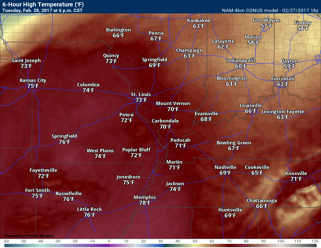
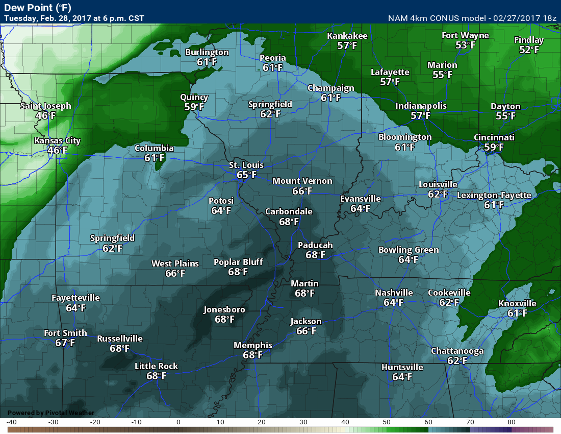
Check out these amazing temperatures for Tuesday afternoon and then the dew points. High dew points, as well. Lot of moisture in the atmosphere. Unstable atmosphere.
Dew point map
Tuesday night and Wednesday morning:
All modes of severe weather will be possible IF the CAP breaks and storms form ahead of a squall line.
What is a squall line? A squall line is a line of thunderstorms that forms along and ahead of cold fronts. Squall lines can produce hail, damaging winds, and occasionally short lived tornadoes.
The big question will be supercells. Do supercells form ahead of the cold front.
Supercells are the storms that produce large hail, damaging winds, and longer tracked tornadoes.
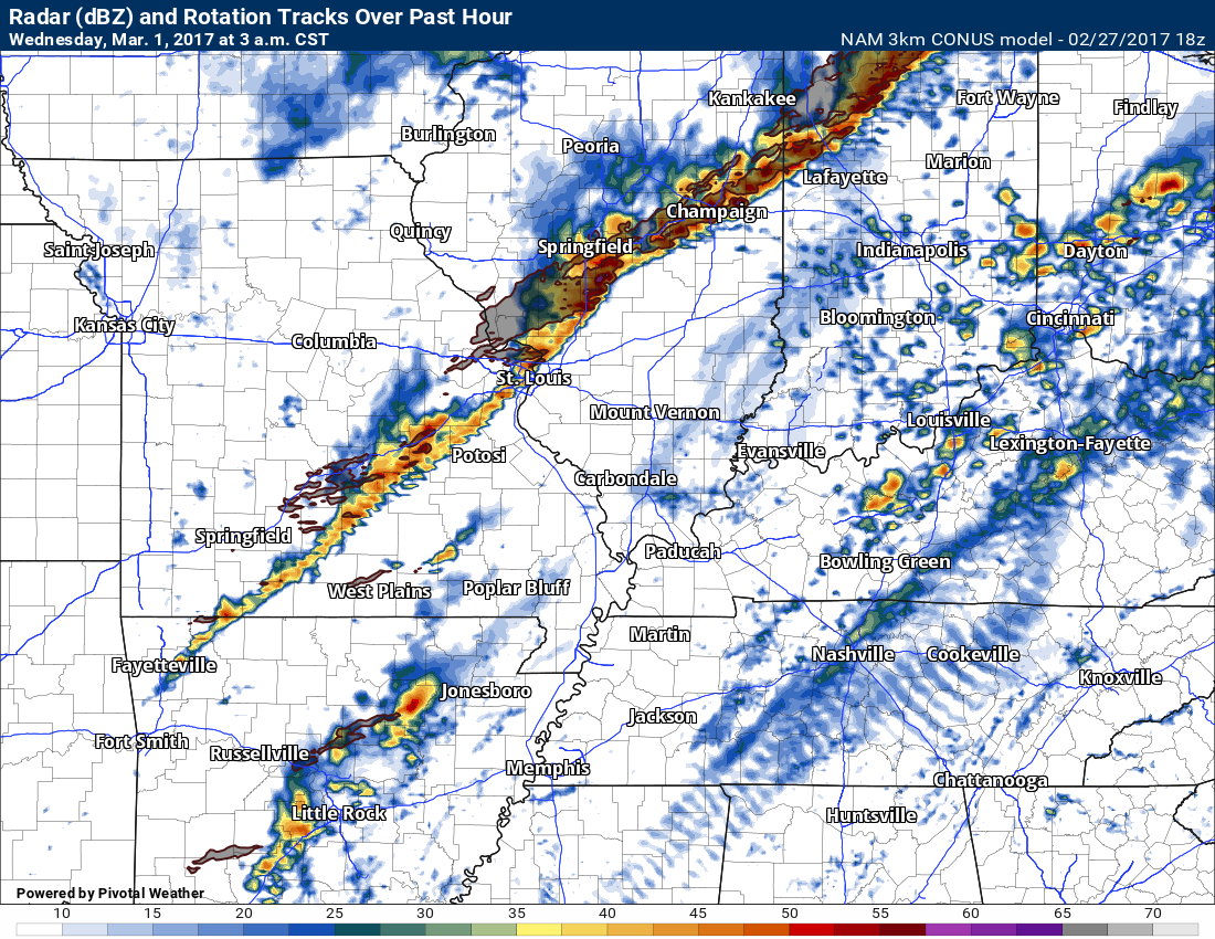
You can see here on the 3K NAM guidance the squall line to our northwest on Tuesday night. It will sweep across the region on Tuesday night and Wednesday. Look ahead of the squall line. Those are supercells. This is what we need to closely monitor.
You can see some supercells in Arkansas. These would race northeast at 60 to 70 mph. Fast moving storms.
The local NWS offices, the Storm Prediction Center, and every local meteorologist is currently wrestling with this question.
I always tell you when I don’t know.
I don’t know if supercells will form ahead of the squall line.
I am confident a squall line forms and moves through the area after midnight on Tuesday night/Wednesday morning.
Even if supercells don’t form, the squall line will be capable of producing wind damage, hail, and short-lived tornadoes.
I would encourage you to monitor updated forecasts. This will most likely be an all night event. Meaning, Tuesday night and Wednesday morning will need to be monitored by forecasters.
It is possible the worst of the weather will occur between 12 am Wednesday and 9 am Wednesday. That means it will be occurring while most people sleep. Thus, the reason I told you to make sure your weather radios are working and you have your text messages working.
I monitor all of the latest guidance and update accordingly.
On Tuesday night I will be with you all night to track the storms.
CAP
The Beau Dodson Weather APP is ready for Apple users (Android is next). The purpose of this APP is for me to deliver your text messages instantly. ATT and Verizon have not always been reliable when it comes to speed. The APP allows instant delivery. You can keep your test messages on and use the APP. You can set the APP to turn off your text messages and just receive them through the APP.
We are working on the Android APP. Hopefully, it will be available in a week or so.
The APP is for subscribers.
The direct download can be viewed here
https://itunes.apple.com/us/app/id1190136514
If you have not signed up for the texting service then you may do so at www.beaudodsonweather.com
If you have not signed up for the texts messages, then please do. Your support helps with all of this
and


