.
Click one of the links below to take you directly to that section
![]()
![]()
![]()
![]()
![]()
![]()
![]()
Do you have any suggestions or comments? Email me at beaudodson@usawx.com
.
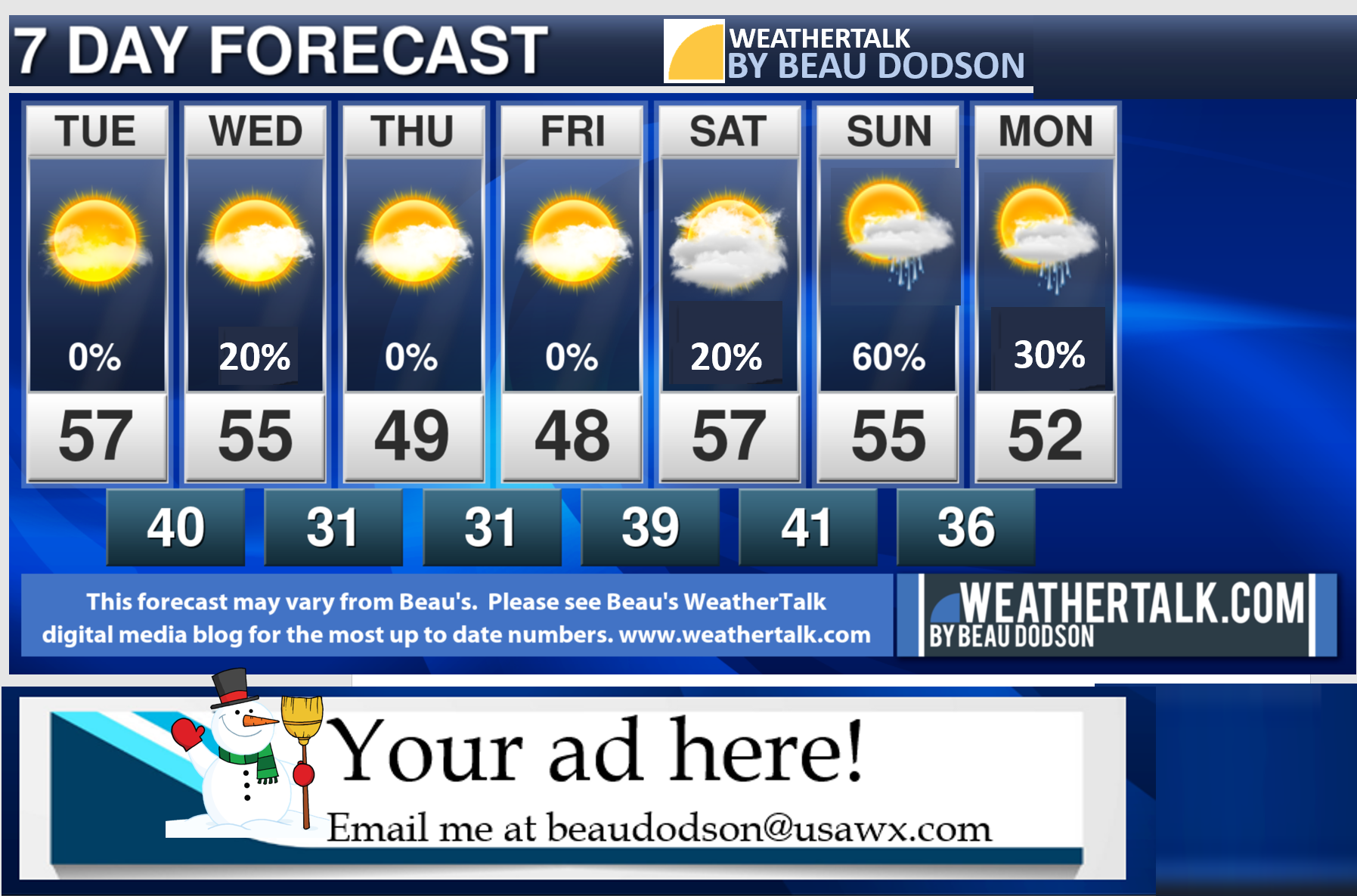
7-day forecast for southeast Missouri, southern Illinois, western Kentucky, and western Tennessee.
This is a BLEND for the region. See the detailed region by region forecast further down in this post.
.


.
.
.

.
Tuesday to Tuesday
1. Are accumulating snow or ice in the forecast? No.
2. Is lightning in the forecast? Monitor. I am watching Sunday. I will also keep an eye on Tuesday onward. I can’t rule out lightning.
3. Are severe thunderstorms in the forecast? No.
* The NWS officially defines a severe thunderstorm as a storm with 58 mph wind or greater, 1″ hail or larger, and/or tornadoes
4. Is flash flooding in the forecast? Monitor. Locally heavy rain into next week, esp over our southern counties of the Missouri Bootheel into Kentucky/Tennessee, may have some issues. Monitor updates.
6. Will the wind chill dip below 10 degrees above zero? No.
.
..

.
February 23, 2021
How confident am I that this days forecast will verify? High Confidence
Tuesday Forecast: Mostly sunny. Mild!!! Patchy AM fog.
What is the chance of precipitation? SE MO ~ 0% IL ~ 0% KY ~ 0% TN ~ 0%
Temperature range: MO Bootheel 62° to 65° SE MO 58° to 65° South IL 60° to 65° Northwest KY (near Indiana border) 60° to 65° West KY 62° to 65° NW TN 62° to 65°
Wind direction and speed: West southwest becoming south southwest at 6 to 12 mph
Wind chill or heat index (feels like) temperature forecast: 56° to 64°
Coverage of precipitation: None
What impacts are anticipated from the weather? None
Should I cancel my outdoor plans? No
UV Index: 3. Moderate
Sunrise: 6:34 AM
Sunset: 5:44 PM
.
Tuesday night Forecast: Increasing clouds. A slight chance of fog.
What is the chance of precipitation? SE MO ~ 0% IL ~ 0% KY ~ 0% TN ~ 0%
Temperature range: MO Bootheel 42° to 44° SE MO 40° to 42° South IL 38° to 42° Northwest KY (near Indiana border) 38° to 42° West KY 40° to 44° NW TN 40° to 44°
Wind direction and speed: South southwest at 5 to 10 mph with gusts to 18 mph.
Wind chill or heat index (feels like) temperature forecast: 32° to 40°
Coverage of precipitation: None
What impacts are anticipated from the weather? Low visibility in fog.
Should I cancel my outdoor plans? No
Moonrise: 1:51 PM
Moonset: 4:13 AM
The phase of the moon: Waxing Gibbous
.
February 24, 2021
How confident am I that this days forecast will verify? High Confidence
Wednesday Forecast: Intervals of clouds. A slight chance of sprinkles.
What is the chance of precipitation? SE MO ~ 20% IL ~ 20% KY ~ 20% TN ~ 20%
Temperature range: MO Bootheel 54° to 56° SE MO 52° to 55° South IL 52° to 55° Northwest KY (near Indiana border) 52° to 55° West KY 54° to 56° NW TN 54° to 58°
Wind direction and speed: South southwest at 8 to 16 mph. Gusty.
Wind chill or heat index (feels like) temperature forecast: 48° to 55°
Coverage of precipitation: None to isolated
What impacts are anticipated from the weather? None
Should I cancel my outdoor plans? No
UV Index: 4. Moderate
Sunrise: 6:32 AM
Sunset: 5:45 PM
.
Wednesday night Forecast: Cloudy with a small chance of showers before 1 AM before temperatures fall below freezing.
What is the chance of precipitation? SE MO ~ 20% IL ~ 20% KY ~ 20% TN ~ 20%
Temperature range: MO Bootheel 30° to 34° SE MO 26° to 30° South IL 26° to 30° Northwest KY (near Indiana border) 28° to 30° West KY 28° to 32° NW TN 30° to 34°
Wind direction and speed: North 8 to 16 mph. Gusty.
Wind chill or heat index (feels like) temperature forecast: 20° to 30°
Coverage of precipitation: None to isolated
What impacts are anticipated from the weather? Isolated wet roadways
Should I cancel my outdoor plans? No
Moonrise: 2:54 PM
Moonset: 5:03 AM
The phase of the moon: Waxing Gibbous
.
February 25, 2021
How confident am I that this days forecast will verify? High Confidence
Thursday Forecast: Partly cloudy. Cooler. A few clouds.
What is the chance of precipitation? SE MO ~ 0% IL ~ 0% KY ~ 0% TN ~ 0%
Temperature range: MO Bootheel 50° to 52° SE MO 44° to 48° South IL 44° to 48° Northwest KY (near Indiana border) 44° to 48° West KY 44° to 48° NW TN 44° to 48°
Wind direction and speed: North at 7 to 14 mph
Wind chill or heat index (feels like) temperature forecast: 40° to 45°
Coverage of precipitation: None
What impacts are anticipated from the weather? None
Should I cancel my outdoor plans? No
UV Index: 2. Low
Sunrise: 6:31 AM
Sunset: 5:46 PM
.
Thursday night Forecast: Increasing clouds. A slight chance of a shower. The NWS has snow and rain mix. Either way, I am not expecting impacts.
What is the chance of precipitation? SE MO ~ 20% IL ~ 10% KY ~ 20% TN ~ 20%
Temperature range: MO Bootheel 28° to 30° SE MO 25° to 30° South IL 24° to 28° Northwest KY (near Indiana border) 25° to 30° West KY 28° to 32° NW TN 30° to 34°
Wind direction and speed: Northeast at 4 to 8 mph
Wind chill or heat index (feels like) temperature forecast: 22° to 28°
Coverage of precipitation: None to isolated
What impacts are anticipated from the weather? None
Should I cancel my outdoor plans? No
Moonrise: 4:01 PM
Moonset: 5:47 AM
The phase of the moon: Waxing Gibbous
.
February 26, 2021
How confident am I that this days forecast will verify? Medium Confidence
Friday Forecast: Partly cloudy. A chance of scattered showers. A slight chance of wet snowflakes mixing in with the snow. The NWS has a rain and snow mix with no impacts.
What is the chance of precipitation? SE MO ~ 30% IL ~ 20% KY ~ 30% TN ~ 50%
Temperature range: MO Bootheel 44° to 48° SE MO 43° to 46° South IL 43° to 46° Northwest KY (near Indiana border) 44° to 48° West KY 44° to 48° NW TN 44° to 48°
Wind direction and speed: East northeast at 5 to 10 mph
Wind chill or heat index (feels like) temperature forecast: 40° to 45°
Coverage of precipitation: Scattered
What impacts are anticipated from the weather? Wet roadways.
Should I cancel my outdoor plans? No, but check radars
UV Index: 3. Medium.
Sunrise: 6:30 AM
Sunset: 5:47 PM
.
Friday night Forecast: Cloudy. A small chance of showers over mainly western Kentucky and northwest Tennessee.
What is the chance of precipitation? SE MO ~ 20% IL ~ 10% KY ~ 20% TN ~ 20%
Temperature range: MO Bootheel 40° to 44° SE MO 32° to 35° South IL 32° to 35° Northwest KY (near Indiana border) 32° to 35° West KY 34° to 38° NW TN 42° to 45°
Wind direction and speed: East southeast at 7 to 14 mph
Wind chill or heat index (feels like) temperature forecast: 28° to 36°
Coverage of precipitation: Isolated
What impacts are anticipated from the weather? None for most
Should I cancel my outdoor plans? No
Moonrise: 5:11 PM
Moonset: 6:26 AM
The phase of the moon: Full
.
February 27, 2021
How confident am I that this days forecast will verify? LOW Confidence
Confidence in rain chances Saturday are low. I need to monitor a possible cold front during that time-frame. For now, I introduced low-end rain chances.
Saturday Forecast: Partly sunny. Let’s keep an eye on rain chances nudging into the area from the south.
What is the chance of precipitation? SE MO ~ 40% IL ~ 30% KY ~ 40% TN ~ 50%
Temperature range: MO Bootheel 55° to 60° SE MO 54° to 58° South IL 54° to 58° Northwest KY (near Indiana border) 54° to 58° West KY 54° to 58° NW TN 54° to 58°
Wind direction and speed: South southeast at 7 to 14 mph
Wind chill or heat index (feels like) temperature forecast: 50° to 55°
Coverage of precipitation: None to isolated
What impacts are anticipated from the weather? None for most. Perhaps some isolated wet roadways.
Should I cancel my outdoor plans? No, but monitor updates
UV Index: 4. Medium.
Sunrise: 6:28 AM
Sunset: 5:48 PM
.
Saturday night Forecast: Cloudy. A chance of showers.
What is the chance of precipitation? SE MO ~ 60% IL ~ 60% KY ~ 70% TN ~ 70%
Temperature range: MO Bootheel 44° to 46° SE MO 38° to 44° South IL 38° to 44° Northwest KY (near Indiana border) 38° to 44° West KY 42° to 44° NW TN 44° to 48°
Wind direction and speed: Southeast at 5 to 10 mph with gusts to 15 mph
Wind chill or heat index (feels like) temperature forecast: 35° to 45°
Coverage of precipitation: Scattered to perhaps numerous
What impacts are anticipated from the weather? Wet roadways
Should I cancel my outdoor plans? No, but check radars
Moonrise: 6:21 PM
Moonset: 7:01 AM
The phase of the moon: Full
.
February 28, 2021
How confident am I that this days forecast will verify? LOW Confidence
Sunday Forecast: Mostly cloudy. A chance of showers. A chance of a thunderstorm.
What is the chance of precipitation? SE MO ~ 50% IL ~ 50% KY ~ 60% TN ~ 60%
Temperature range: MO Bootheel 54° to 58° SE MO 53° to 56° South IL 52° to 55° Northwest KY (near Indiana border) 52° to 55° West KY 52° to 55° NW TN 54° to 58°
Wind direction and speed: South southwest at 5 to 10 mph with gusts to 15 mph.
Wind chill or heat index (feels like) temperature forecast: 45° to 55°
Coverage of precipitation: Scattered to numerous.
What impacts are anticipated from the weather? Wet roadways. Lightning.
Should I cancel my outdoor plans? No, but check radars and monitor updates.
UV Index: 3. Medium.
Sunrise: 6:27 AM
Sunset: 5:45 PM
.
Sunday night Forecast: Cloudy. A chance of showers.
What is the chance of precipitation? SE MO ~ 50% IL ~ 40% KY ~ 50% TN ~ 50%
Temperature range: MO Bootheel 43° to 46° SE MO 40° to 44° South IL 40° to 44° Northwest KY (near Indiana border) 40° to 44° West KY 42° to 44° NW TN 44° to 48°
Wind direction and speed: North at 7 to 14 mph. Gusty.
Wind chill or heat index (feels like) temperature forecast: 38° to 44°
Coverage of precipitation: Scattered to perhaps numerous. Lower confidence.
What impacts are anticipated from the weather? Wet roadways. Lightning.
Should I cancel my outdoor plans? No, but check radars and monitor updates.
Moonrise: 7:33 PM
Moonset: 7:34 AM
The phase of the moon: Waning Gibbous
.
.

Double click on the images to enlarge them.

.
.
![]()
![]()
Graphic-cast
Click here if you would like to return to the top of the page.
Illinois
During active weather check my handwritten forecast towards the top of the page.

.
Kentucky
During active weather check my handwritten forecast towards the top of the page.


.

.

.
.Tennessee
During active weather check my handwritten forecast towards the top of the page.

.
.
Today through February 28th. Severe weather is not anticipated.
.
Today’s outlook (below).
Light green is where thunderstorms may occur but should be below severe levels.
Dark green is a level one risk. Yellow is a level two risk. Orange is a level three (enhanced) risk. Red is a level four (moderate) risk. Pink is a level five (high) risk.
One is the lowest risk. Five is the highest risk.
A severe storm is one that produces 58 mph wind or higher, quarter size hail, and/or a tornado.
The tan states are simply a region that SPC outlined on this particular map. Just ignore that.

The black outline is our local area.

.
Tomorrow’s severe weather outlook.

.

.
The images below are from the WPC. Their totals are a bit lower than our current forecast. I wanted to show you the comparison.
24-hour precipitation outlook.
.
 .
.
48-hour precipitation outlook.
.
.
72-hour precipitation outlook.
.
.
![]()

![]()
..
Weather advice:
.
Weather Discussion
-
- A mild day ahead of us! Enjoy it.
- Weak cold front Wednesday/Wednesday night will knock a few degrees off the thermometer.
- Watching the weekend into next week for a more active weather pattern.
.
.
Fairly calm weather over the next 24 to 48 hours.
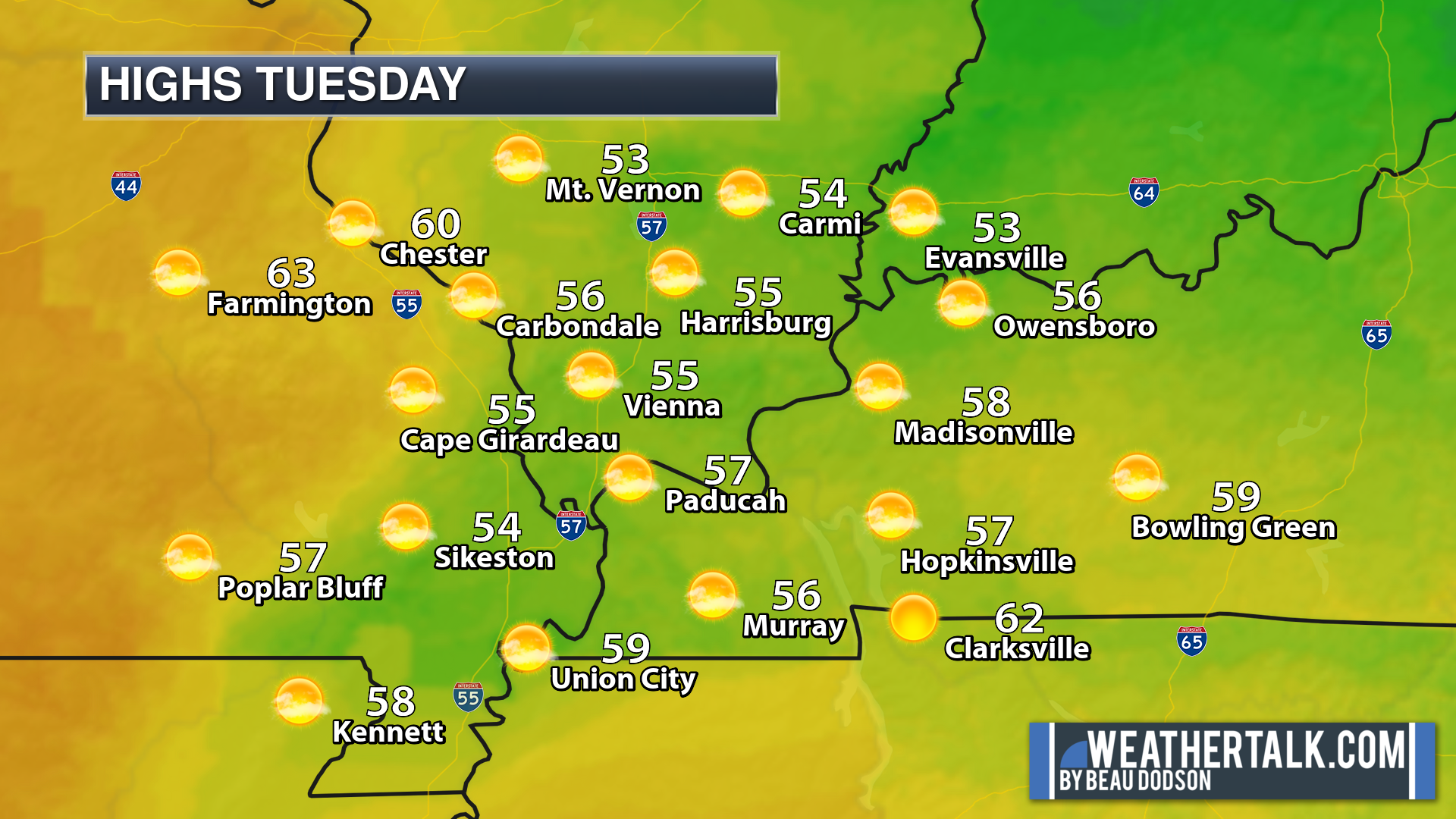
Today will be nice. Temperatures in the 50s. Some sunshine will make it feel warmer. Our snow is disappearing in most areas.
Some locations may top 60 degrees this afternoon. We will take that without any complaints!
This graphic is a keeper.
.
A cold front will push across the region Wednesday. There is not much moisture to work with. Thus, I only have a small chance of light rain in the county by county forecast.
This front will help to drop temperatures Wednesday night into Friday. Not by much, but you will notice a difference from today’s nice weather.
No arctic cold outbreaks in the charts! I do believe we see another solid cold shot in March. That would be before spring arrives (which is not far off). We can even have wet snow in March. Let’s see how that trends over the coming weeks. For now, snow free weather is the going forecast.
Northwest winds will develop behind the cold front, as well. Gusty, at times.
Forecast headaches begin over the weekend.
A well-advertised series of southern systems will push across the Gulf of Mexico States. This raises questions about our local area.
We will be on the northern edge of many of these systems.
If it were going to be colder, then we would be dealing with snow and ice.
That is not the case. It will be mild enough for an all rain event or mostly rain event. The NWS does have wet snowflakes mixed with rain Thursday night with zero accumulation.
I have rain in the forecast, for now.
Either way, snow and ice are not a concern through next Wednesday.
Rain totals are a concern. The ground is still frozen and soggy. We do not need heavy rain.
The chance of heavy rain is higher from Arkansas into Tennessee. Areas further north will want to monitor updates. Any shift in the warm front and area of low pressure will mean a shift in the heavy rain totals.
I posted some maps below.
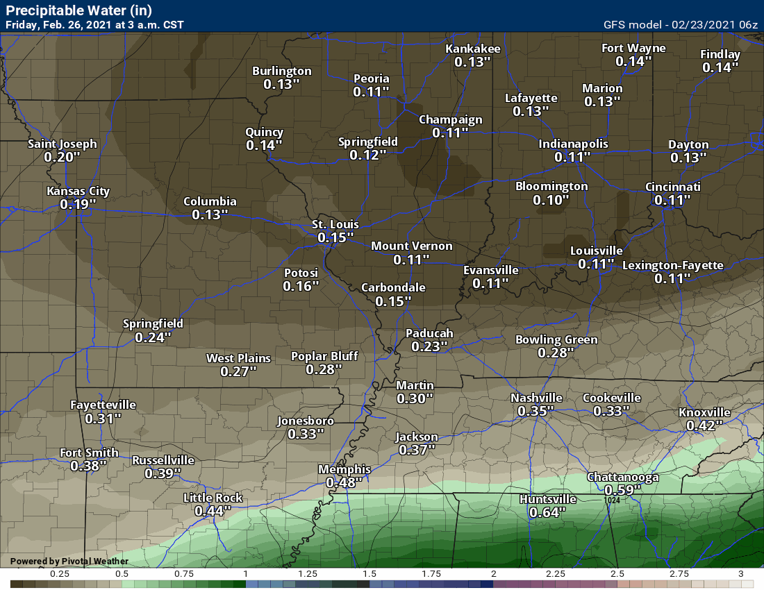
Precipitable water values will be on the rise. I have not discussed PWAT values in months. No reason too!

But, that is changing. Let’s take a look at the GFS model PWAT value forecast.
Notice they are higher to our south vs north. That is the boundary we will need to closely monitor over the coming seven to ten days.
.
There are a couple of time periods where rain appears more likely.
There will be a chance of a few rain showers Thursday night and Friday. A better chance Sunday into Sunday night and another chance around next Tuesday into Thursday.
This will be a series of systems. The forecast will be complicated for any 24-hour period. Especially, this far out. Thus, adjustments in the timing will be possible.
For example, some models are dry Saturday and the GFS model shows locally heavy rain Saturday.
Stay tuned. Some flooding may occur if some of these southern systems drift northward.
At this time, severe weather appears a no-go through next Tuesday. I can’t 100% rule out lightning Sunday.
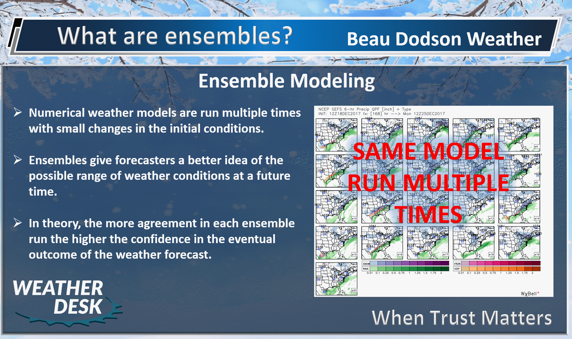
Let me show you some ensemble graphics.
What are ensembles?
First, the EC ensembles.
There is a strong signal for locally heavy rain between now and next Thursday.
A few rain events will be possible.
Questions remain on how far north to take the precipitation. Notice the higher totals are over the Tennessee Valley.
The second image is snow. I do not expect accumulating snow through next Thursday.
These maps represent the Mean of the ensembles.
Double click on the images to enlarge them.


.
Now the GFS ensembles.
Notice the EC and GFS agree on the placement of the heavier rain totals.
This is a strong signal for locally heavy rain in the Tennessee Valley through next Thursday.
The second image would be the snow forecast. I do not expect accumulating snow in our local area.


.
The WPC/NOAA is forecasting these rain totals. Again, there may be adjustments north or south.

.
Click on the images below to enlarge them.
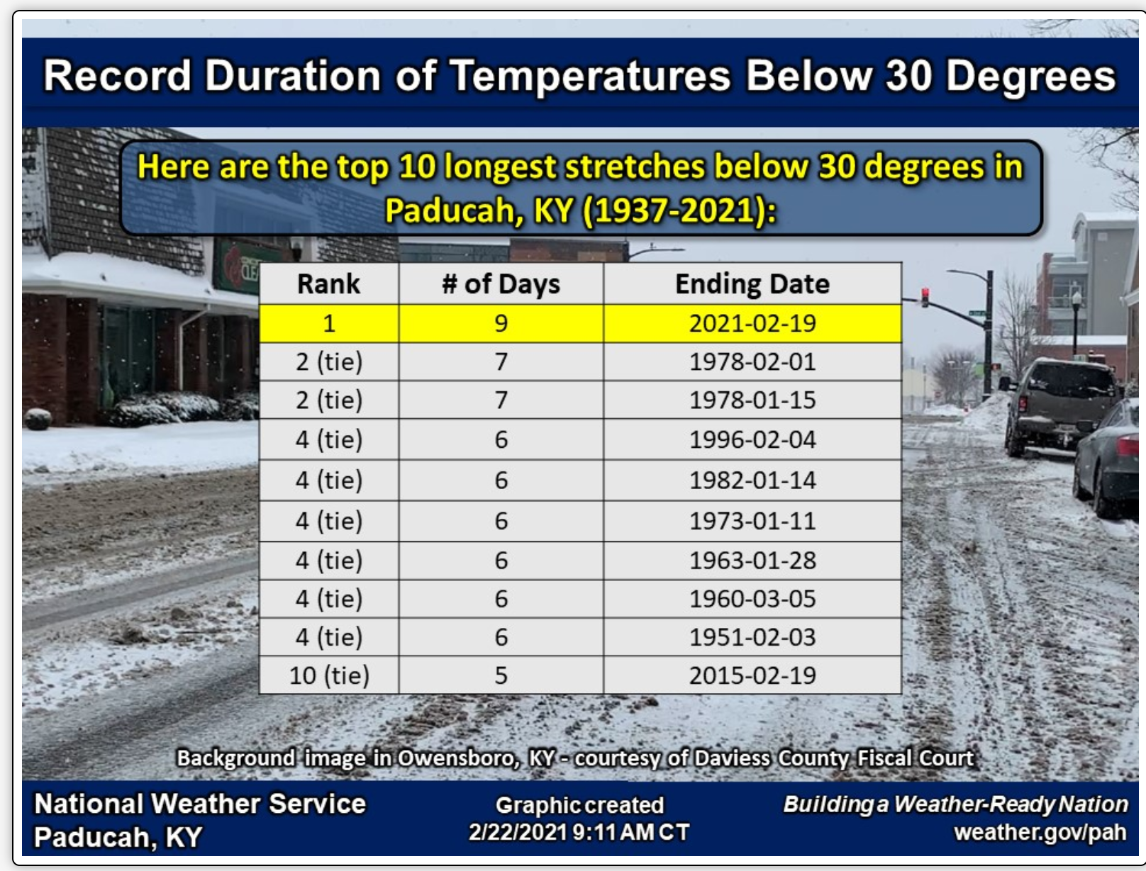
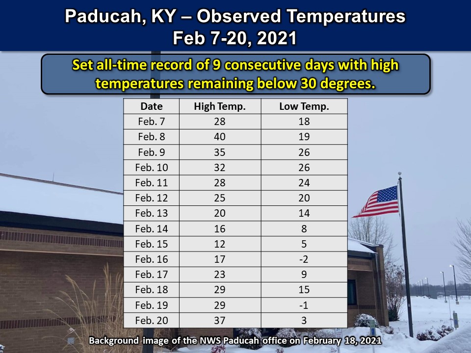
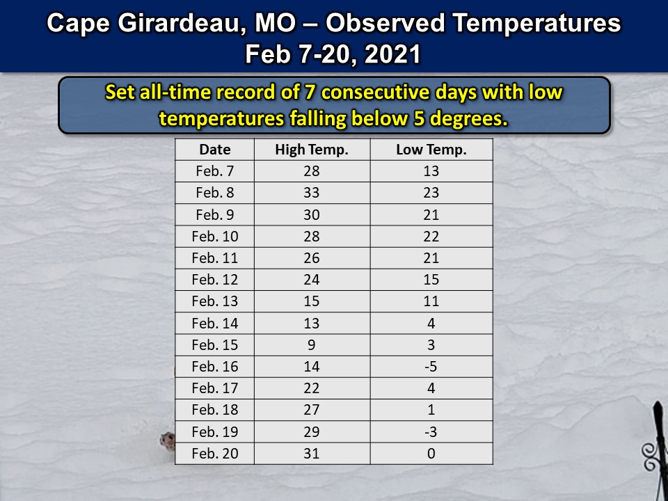
A review of our recent cold outbreak and storm events. This was put together by the Paducah, Kentucky, NWS.


.


Click here if you would like to return to the top of the page.
Again, as a reminder, these are models. They are never 100% accurate. Take the general idea from them.
What should I take from these?
- The general idea and not specifics. Models usually do well with the generalities.
- The time-stamp is located in the upper left corner.
- The EC European weather model is in Zulu time.
.
What am I looking at?
You are looking at different models. Meteorologists use many different models to forecast the weather. All models are wrong. Some are more wrong than others. Meteorologists have to make a forecast based on the guidance/models.
I show you these so you can see what the different models are showing as far as precipitation. If most of the models agree, then the confidence in the final weather forecast increases.
You can see my final forecast at the top of the page.
.
This animation is the Storm Prediction Center WRF model.
This animation shows you what radar might look like as the next system pulls through the region. It is a future-cast radar.
Time-stamp upper left. Click the animation to enlarge it.
No precip
.
This animation is the Hrrr short-range model.
No precip
.
This animation is the 3K NAM American Model.
This animation shows you what radar might look like as the next system pulls through the region. It is a future-cast radar.
Time-stamp upper left. Click the animation to enlarge it.
No precip
.
This next animation is the lower-resolution NAM American Model.
This animation shows you what radar might look like as the system pulls through the region. It is a future-cast radar.
Time-stamp upper left. Click the animation to enlarge it.
.
This next animation is the GFS American Model.
This animation shows you what radar might look like as the system pulls through the region. It is a future-cast radar.
Time-stamp upper left. Click the animation to enlarge it.
The system later today and tonight. Weak event.
Short-range. The GFS pops some light sprinkles along the incoming Wednesday cold front. Do not expect much if anything at all.
And longer-range
.
This next animation is the EC European Weather model.
This animation shows you what radar might look like as the system pulls through the region. It is a future-cast radar.
Time-stamp upper left. Click the animation to enlarge it.
System one. Today/tonight.

.
.
![]()
.


.
Click here if you would like to return to the top of the page.
.
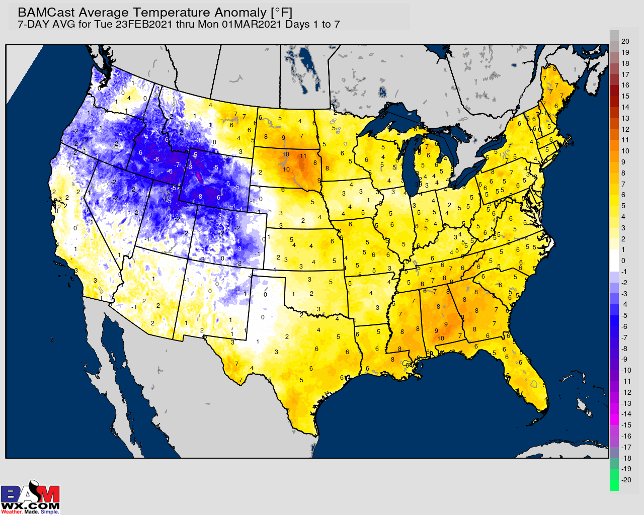
Average high temperatures for this time of the year are around 52 degrees.
Average low temperatures for this time of the year are around 32 degrees.
Average precipitation during this time period ranges from 0.70″ to 1.00″
Yellow and orange colors are above average temperatures. Red is much above average. Light blue and blue are below-average temperatures. Green to purple colors represents much below-average temperatures.
This outlook covers February 23rd through March 1st
Click on the image to expand it.
.
.
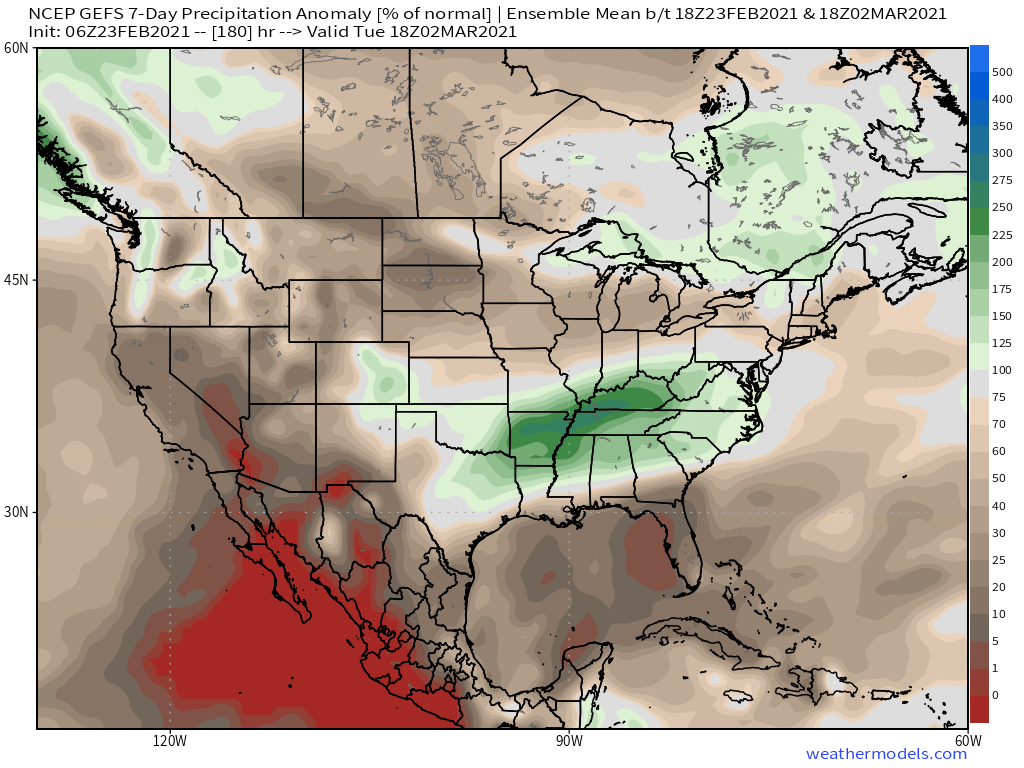
The precipitation forecast is PERCENT OF AVERAGE. Brown is below average. Green is above average. Blue is much above average.
.

Average low temperatures for this time of the year are around 34 degrees
Average precipitation during this time period ranges from 0.70″ to 1.00″
.
This outlook covers March 2nd through March 8th
Click on the image to expand it.

.
The precipitation forecast is PERCENT OF AVERAGE. Brown is below average. Green is above average. Blue is much above average.
.
.

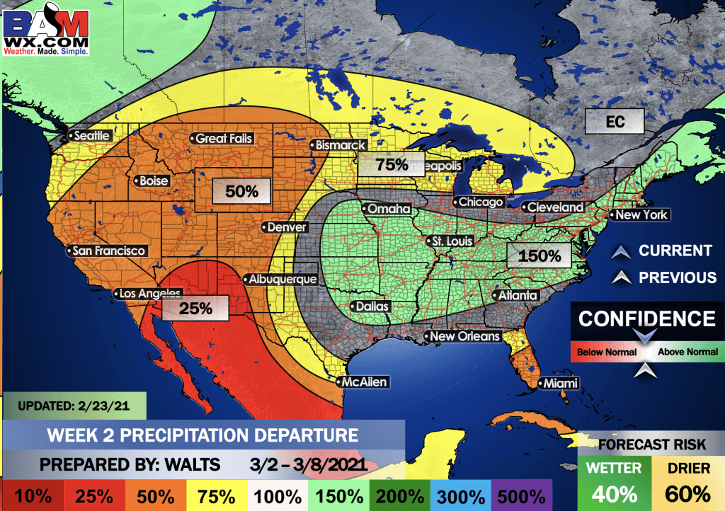
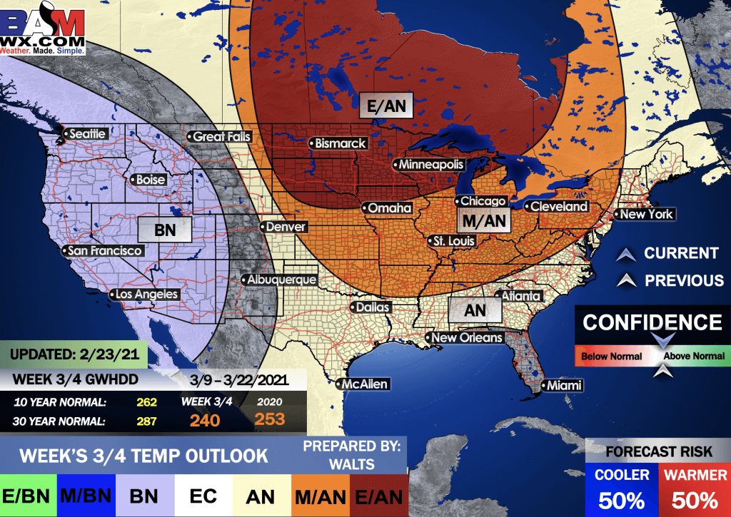
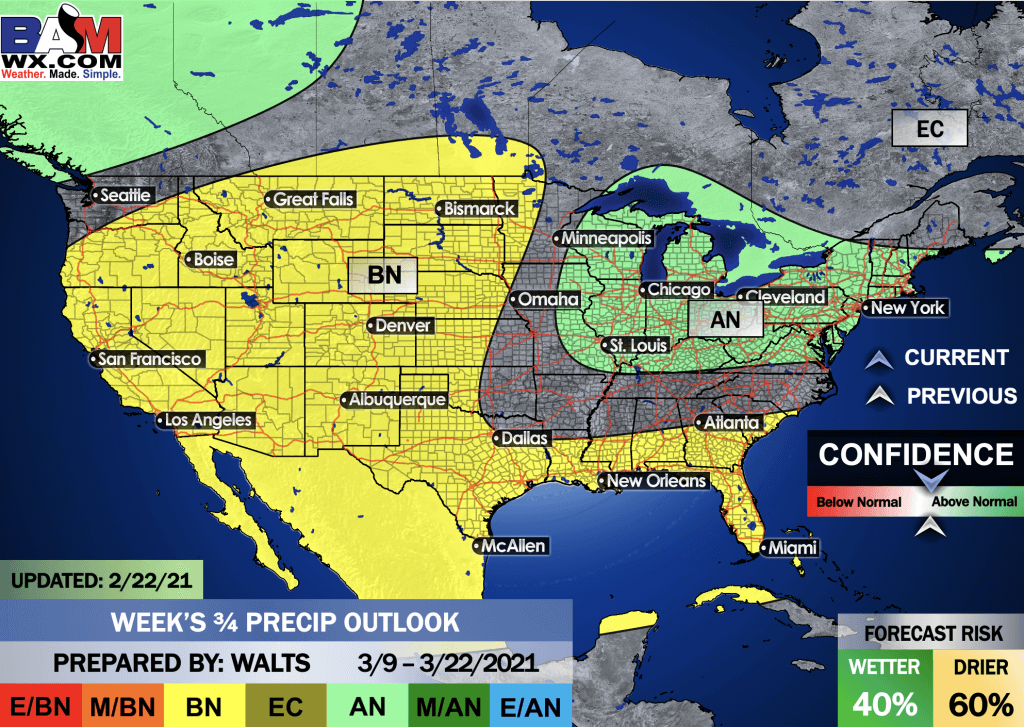
EC = Equal chances of above or below average
BN= Below average
M/BN = Much below average
AN = Above average
M/AN = Much above average
E/AN = Extremely above average
Average low temperatures for this time of the year are around 37 degrees
Average precipitation during this time period ranges from 1.40″ to 2.00″
This outlook covers March 9th through March 22nd
.
Precipitation outlook
LONG RANGE DISCUSSION
Key Points: This was written by the BAMwx team. I don’t edit it.
.
E/BN extremely below normal.
M/BN is much below normal
EC equal chances
AN above normal
M/AN much above normal
E/AN extremely above normal.
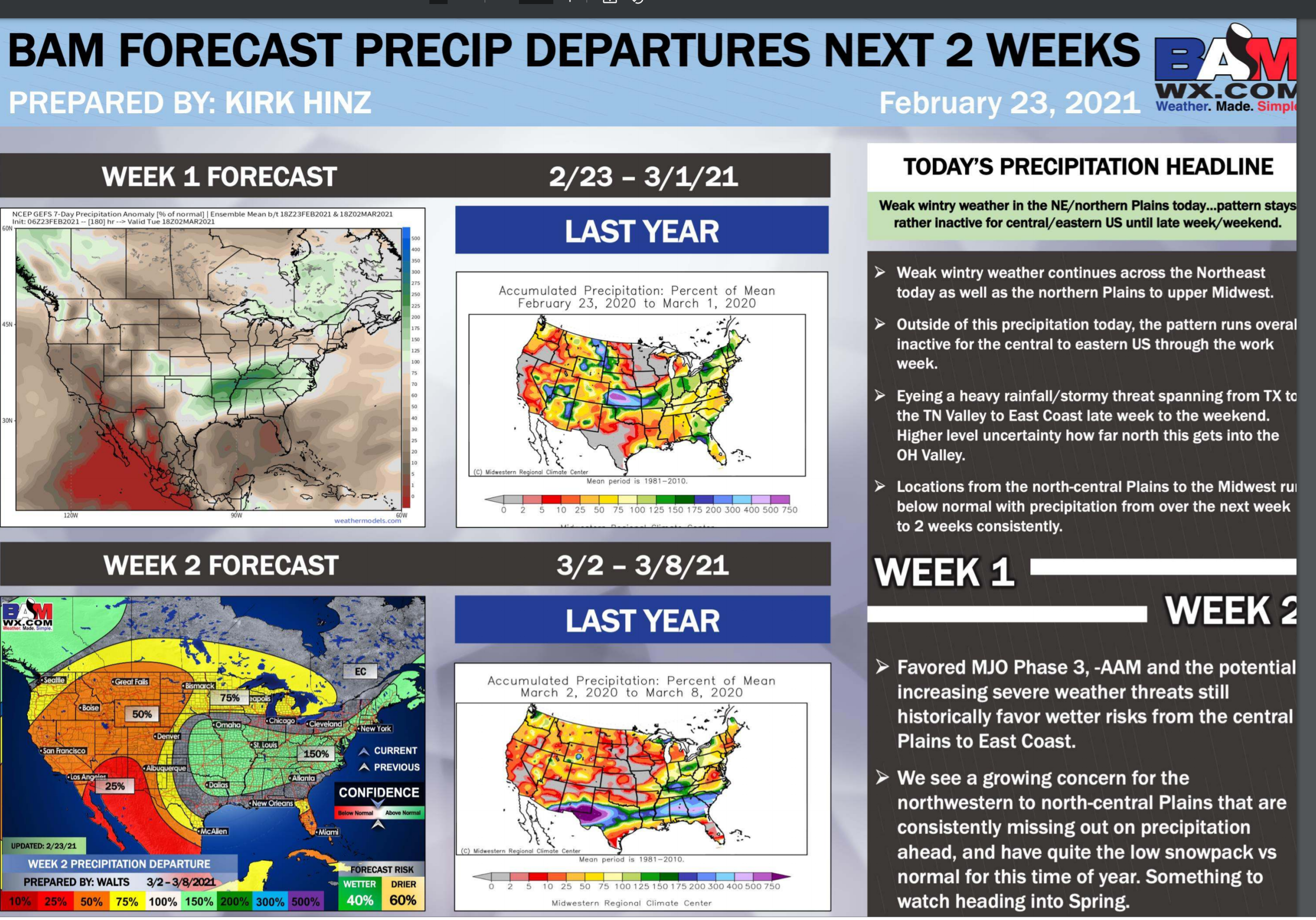
February Temperature Outlook
.
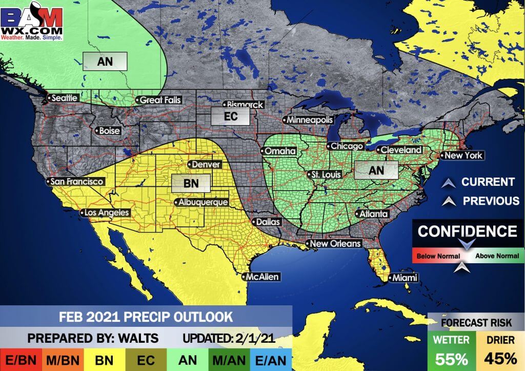
February Precipitation Outlook
.
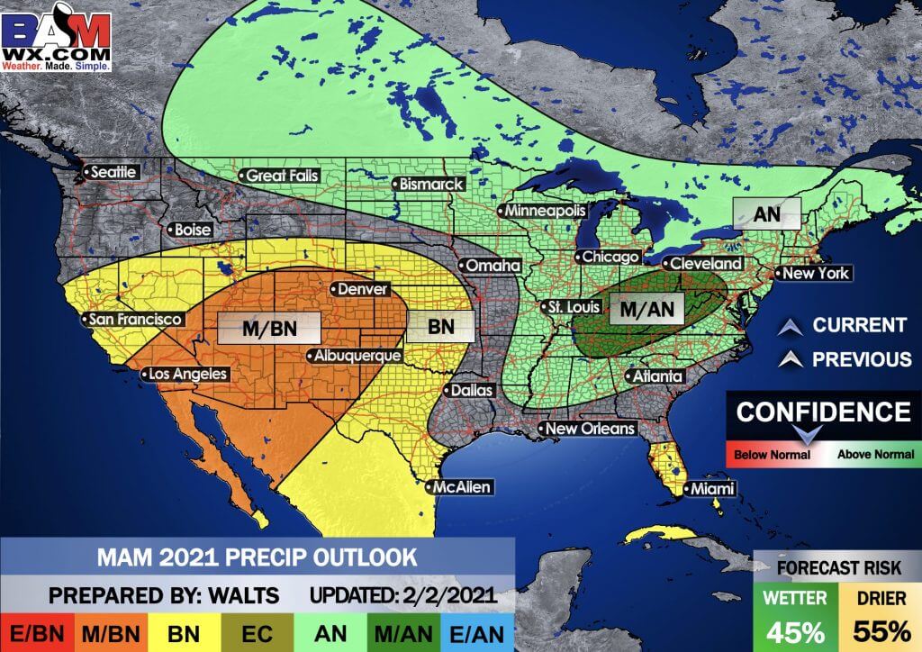
Spring Outlook
E/BN extremely below normal.
M/BN is much below normal
EC equal chances
AN above normal
M/AN much above normal
E/AN extremely above normal.
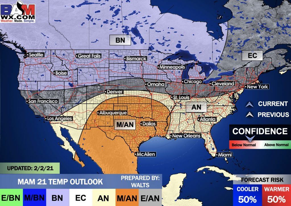
March, April, and May Temperature Outlook
.
March, April, and May Precipitation Outlook
.
E/BN extremely below normal.
M/BN is much below normal
EC equal chances
AN above normal
M/AN much above normal
E/AN extremely above normal.
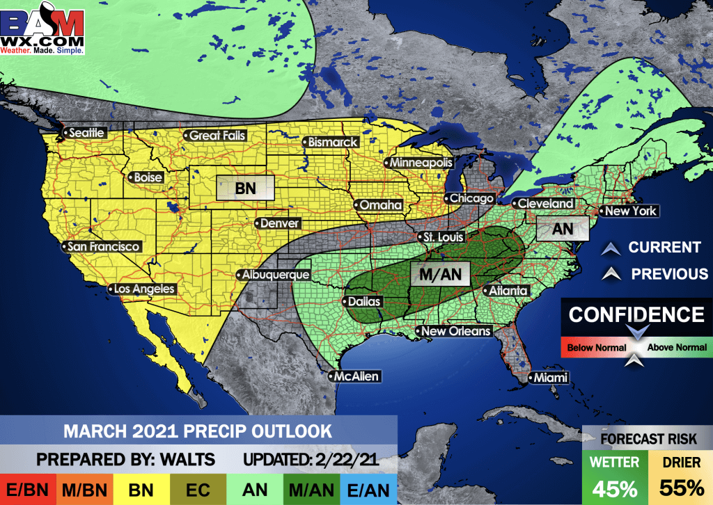
And the preliminary March outlooks
Temperature departures
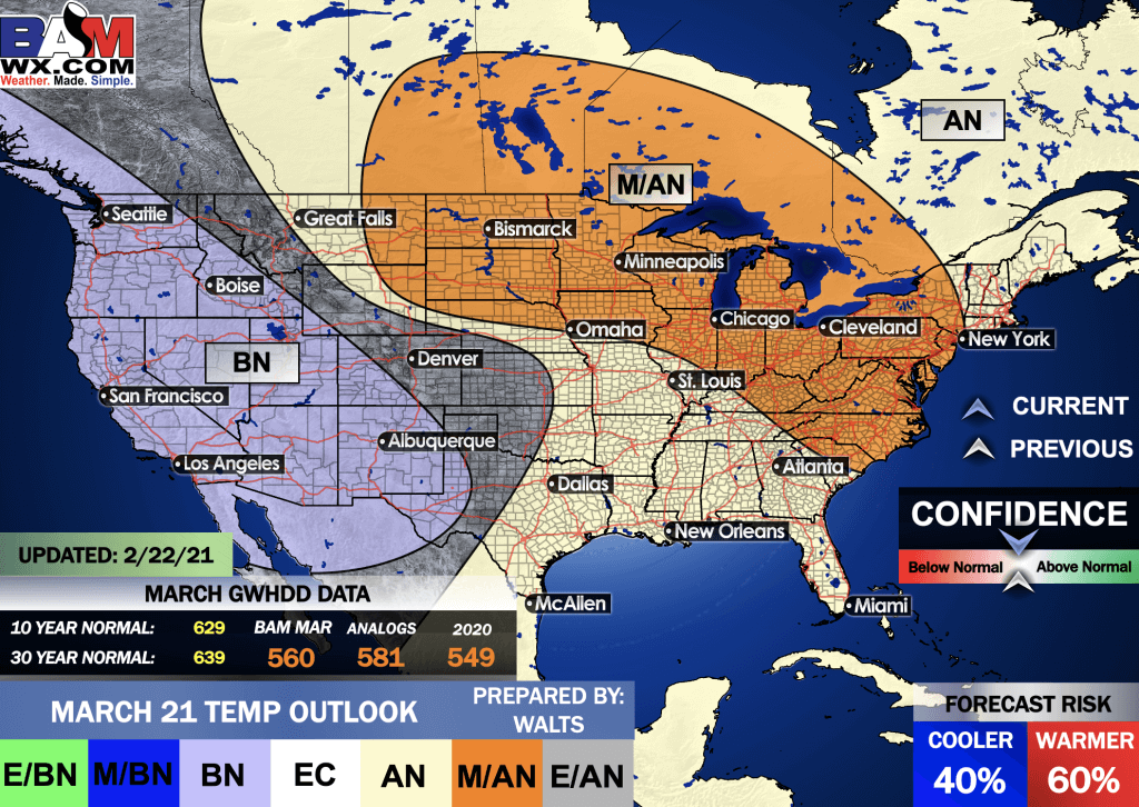
Precipitation
.
And the preliminary April outlooks
E/BN extremely below normal.
M/BN is much below normal
EC equal chances
AN above normal
M/AN much above normal
E/AN extremely above normal.
Temperature departures
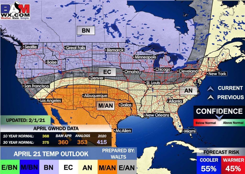
Precipitation
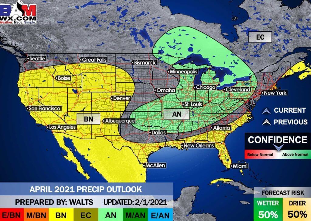
.
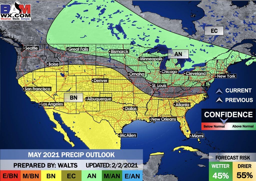
And the preliminary May outlooks
E/BN extremely below normal.
M/BN is much below normal
EC equal chances
AN above normal
M/AN much above normal
E/AN extremely above normal.
Temperature departures
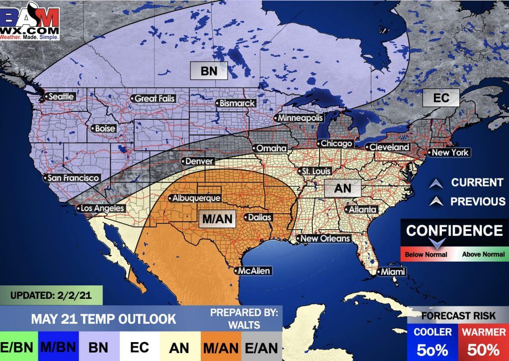
Precipitation
.
![]()

Great news! The videos are now found in your Weathertalk app and on the WeatherTalk website.
These are bonus videos for subscribers.
The app is for subscribers. Subscribe at www.weathertalk.com/welcome then go to your app store and search for WeatherTalk
Subscribers, PLEASE USE THE APP. ATT and Verizon are not reliable during severe weather. They are delaying text messages.
The app is under WeatherTalk in the app store.

Apple users click here

Android users click here
.

Radar Link: Interactive local city-view radars & regional radars.
You will find clickable warning and advisory buttons on the local city-view radars.
If the radar is not updating then try another one. If a radar does not appear to be refreshing then hit Ctrl F5. You may also try restarting your browser.
Not working? Email me at beaudodson@usawx.com
National map of weather watches and warnings. Click here.
Storm Prediction Center. Click here.
Weather Prediction Center. Click here.
.

Live lightning data: Click here.
.

Interactive GOES R satellite. Track clouds. Click here.
GOES 16 slider tool. Click here.
College of Dupage satellites. Click here
.

Here are the latest local river stage forecast numbers Click Here.
Here are the latest lake stage forecast numbers for Kentucky Lake and Lake Barkley Click Here.
.
.
Find Beau on Facebook! Click the banner.


 .
.