This is what you are missing out on if you are not a $3 a month subscriber!
- Daily forecast texts from my computer to your app/cell phone
- Severe weather app/text alerts from my keyboard to your app/cell phone
- Social media links sent directly to your app/cell phone. When I update the blog, videos, or Facebook you will receive the link.
- Missouri Valley centered video updates
- Ohio Valley centered video updates
- Long-range video updates
- Week one temperature and precipitation outlook
- Week two temperature and precipitation outlook
- Week three and four temperature and precipitation outlook
- Monthly outlooks
Monthly operating costs for Weather Talk can top $2000.00. Your $3 subscription helps pay for those costs. I work for you.
.

.
Your $3 per month also helps support these local charity projects.
.

.

.
Interactive Weather Radar Page. Choose the city nearest your location: Click this link.
We offer regional radars and local city radars – if a radar does not update then try another one. Occasional browsers need their cache cleared. You may also try restarting your browser. This will usually fix any problems.
During the winter you can track snow and ice by clicking the winterize button on the local city view interactive radars.
.

.
A flood watch is in effect through Saturday night.
February 23, 2018
Friday Forecast Details
Forecast: Cloudy. Rain likely. Thunderstorms possible. Locally heavy rain.
Temperatures: MO ~ 56 to 62 IL ~ 56 to 60 KY ~ 60 to 65
What is the chance of precipitation? MO ~ 70% IL ~ 70% KY ~ 70% TN ~ 70%
Coverage of precipitation: Widespread
Wind chill values: N/A
Accumulating snow or ice: No
Winds: Variable at 7 to 14 mph with gusts to 18 mph
What impacts are anticipated from the weather? Wet roadways. Lightning. Locally heavy rain.
My confidence in the forecast verifying: High
Is severe weather expected? No
The NWS defines severe weather as 58 mph wind or great, 1″ hail or larger, and/or tornadoes
Should I cancel my outdoor plans? Have a plan B
.
Friday Night Forecast Details:
Forecast: Cloudy. Showers and thunderstorms possible. Locally heavy rain.
Temperatures: MO ~ 48 to 54 IL ~ 46 to 55 KY ~54 to 60
What is the chance of precipitation? MO ~ 70% IL ~ 70% KY ~ 70% TN ~ 70%
Coverage of precipitation: Widespread.
Wind chill values: N/A
Accumulating snow or ice: No
Winds: Northeast and east at 5 to 10 mph with gusts to 16 mph
What impacts are anticipated from the weather? Wet roadways. Lightning. Locally heavy rain.
My confidence in the forecast verifying: Medium
Is severe weather expected? No
The NWS defines severe weather as 58 mph wind or great, 1″ hail or larger, and/or tornadoes
Should I cancel my outdoor plans? Have a plan B
.
February 24, 2018
Saturday Forecast Details
Forecast: Partly to mostly cloudy. Warm. Windy. Periods of showers and thunderstorms. A few storms could be severe during the afternoon hours. Locally heavy rain.
Temperatures: MO ~ 64 to 68 IL ~ 64 to 68 KY ~65 to 70
What is the chance of precipitation? MO ~ 70% IL ~ 70% KY ~ 70% TN ~ 70%
Coverage of precipitation: Numerous
Wind chill values: N/A
Accumulating snow or ice: No
Winds: South and southeast at 14 to 28 mph with higher gusts
What impacts are anticipated from the weather? Wet roadways. Lightning. Heavy rain. Severe storms possible with hail, high winds, and even tornadoes.
My confidence in the forecast verifying: High
Is severe weather expected? Severe thunderstorms are possible during the afternoon. Monitor updates.
The NWS defines severe weather as 58 mph wind or great, 1″ hail or larger, and/or tornadoes
Should I cancel my outdoor plans? Have a plan B
.
Saturday Night Forecast Details:
Forecast: Cloudy. Showers and thunderstorms in the evening. Some storms could be severe. Locally heavy rain. Precipitation ending overnight from west to east. Turning colder.
Temperatures: MO ~ 38 to 44 IL ~ 40 to 45 KY ~ 42 to 46
What is the chance of precipitation? MO ~ 90% IL ~ 90% KY ~ 90% TN ~ 90%
Coverage of precipitation: Numerous, especially the first half of the night.
Wind chill values: N/A
Accumulating snow or ice: No
Winds: South winds at 6 to 12 mph with gusts to 20 mph. Winds becoming west and northwest at 10 to 20 mph.
What impacts are anticipated from the weather? Wet roadways. Lightning. Heavy rain. Severe storms possible with hail, high winds, and even tornadoes.
My confidence in the forecast verifying: Medium
Is severe weather expected? Severe thunderstorms are possible.
The NWS defines severe weather as 58 mph wind or great, 1″ hail or larger, and/or tornadoes
Should I cancel my outdoor plans: Have a plan B
February 25, 2018
Sunday Forecast Details
Forecast: Partly sunny. Cool.
Temperatures: MO ~ 54 to 58 IL ~ 54 to 58 KY ~ 54 to 58
What is the chance of precipitation? MO ~ 0% IL ~ 0% KY ~ 0% TN ~ 0%
Coverage of precipitation: None
Wind chill values: N/A
Accumulating snow or ice: No
Winds: West and northwest at 8 to 16 mph
What impacts are anticipated from the weather? None
My confidence in the forecast verifying: High
Is severe weather expected? No
The NWS defines severe weather as 58 mph wind or great, 1″ hail or larger, and/or tornadoes
Should I cancel my outdoor plans? No
.
Sunday Night Forecast Details:
Forecast: Mostly clear. A few passing clouds. Patchy fog.
Temperatures: MO ~ 35 to 40 IL ~ 35 to 40 KY ~ 36 to 42
What is the chance of precipitation? MO ~ 0% IL ~ 0% KY ~ 0% TN ~ 0%
Coverage of precipitation: None
Wind chill values: N/A
Accumulating snow or ice: No
Winds: North 5 mph with gusts to 10 mph
What impacts are anticipated from the weather? None
My confidence in the forecast verifying: High
Is severe weather expected? No
The NWS defines severe weather as 58 mph wind or great, 1″ hail or larger, and/or tornadoes
Should I cancel my outdoor plans: No
.
February 26, 2018
Monday Forecast Details
Forecast: Partly sunny.
Temperatures: MO ~ 54 to 58 IL ~ 54 to 58 KY ~ 54 to 58
What is the chance of precipitation? MO ~ 0% IL ~ 0% KY ~ 0% TN ~ 0%
Coverage of precipitation: None
Wind chill values: N/A
Accumulating snow or ice: No
Winds: East and northeast at 5 to 10 mph
What impacts are anticipated from the weather? None
My confidence in the forecast verifying: High
Is severe weather expected? No
The NWS defines severe weather as 58 mph wind or great, 1″ hail or larger, and/or tornadoes
Should I cancel my outdoor plans? No
.
Monday Night Forecast Details:
Forecast: A few passing clouds. Cool. Patchy fog.
Temperatures: MO ~ 34 to 38 IL ~ 34 to 38 KY ~ 34 to 38
What is the chance of precipitation? MO ~ 0% IL ~ 0% KY ~ 0% TN ~ 0%
Coverage of precipitation: None
Wind chill values: N/A
Accumulating snow or ice: No
Winds: North and northeast 5 mph
What impacts are anticipated from the weather? None
My confidence in the forecast verifying: High
Is severe weather expected? No
The NWS defines severe weather as 58 mph wind or great, 1″ hail or larger, and/or tornadoes
Should I cancel my outdoor plans: No
.
February 27, 2018
Tuesday Forecast Details
Forecast: Mostly sunny. Mild.
Temperatures: MO ~ 58 to 62 IL ~ 58 to 62 KY ~ 58 to 62
What is the chance of precipitation? MO ~ 0% IL ~ 0% KY ~ 0% TN ~ 0%
Coverage of precipitation: None
Wind chill values: N/A
Accumulating snow or ice: No
Winds: East and southeast at 5 to 10 mph
What impacts are anticipated from the weather? None
My confidence in the forecast verifying: Medium
Is severe weather expected? No
The NWS defines severe weather as 58 mph wind or great, 1″ hail or larger, and/or tornadoes
Should I cancel my outdoor plans? No
.
Tuesday Night Forecast Details:
Forecast: Increasing clouds. A chance of showers late.
Temperatures: MO ~ 42 to 46 IL ~ 42 to 46 KY ~ 42 to 46
What is the chance of precipitation? MO ~ 30% IL ~ 30% KY ~ 30% TN ~ 30%
Coverage of precipitation: Scattered late
Wind chill values: N/A
Accumulating snow or ice: No
Winds: Variable at 4 to 8 mph
What impacts are anticipated from the weather? Wet roadways late.
My confidence in the forecast verifying: Medium
Is severe weather expected? No
The NWS defines severe weather as 58 mph wind or great, 1″ hail or larger, and/or tornadoes
Should I cancel my outdoor plans: No
.

.
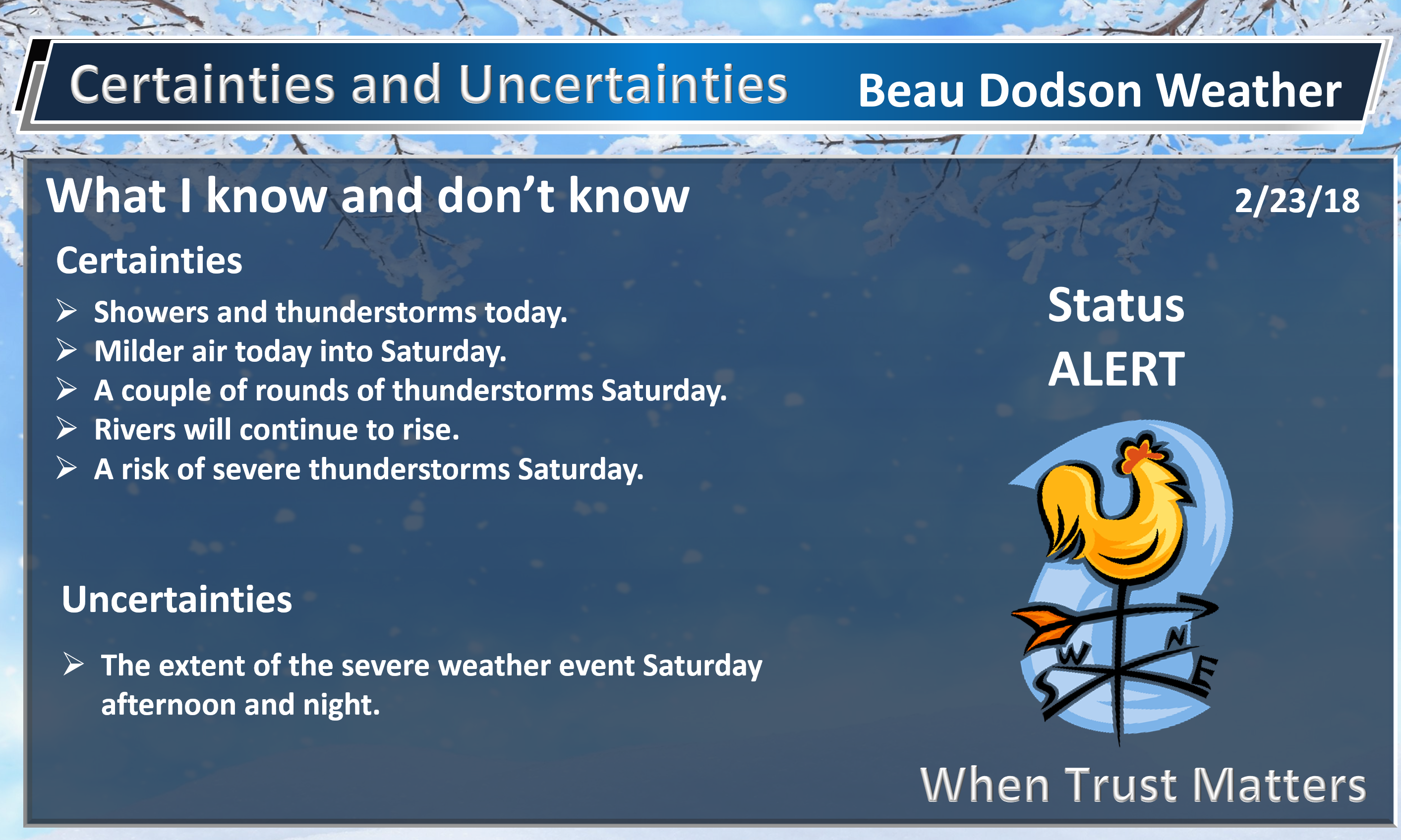
Friday through Wednesday: Winter weather is not anticipated.
.

.
The National Weather Service definition of a severe thunderstorm is one that produces quarter size hail or larger, 58 mph winds or greater, and/or a tornado.
Today through Saturday morning: On and off thunderstorms chances are possible. At this time, the severe weather risk appears low. Lightning will be the main concern. Heavy rain will be a concern.
Saturday afternoon and Saturday night: Monitor updates. Severe storms are possible during this time frame. Large hail, damaging winds, and tornadoes will be the concern. Heavy rain and flash flooding, as well.
.

.
The daily outlook can be found at the bottom of this post.
.
.
We offer regional radars and local city radars – if a radar does not update then try another one. Occasional browsers need their cache cleared. You may also try restarting your browser. This will usually fix any problems.
.
.
.
.
.
We offer regional radars and local city radars – if a radar does not update then try another one. Occasional browsers need their cache cleared. You may also try restarting your browser. This will usually fix any problems.
During the winter you can track snow and ice by clicking the winterize button on the local city view interactive radars.
You may email me at beaudodson@usawx.com
Interactive Weather Radar Page. Choose the city nearest your location: Click this link
Forecast:
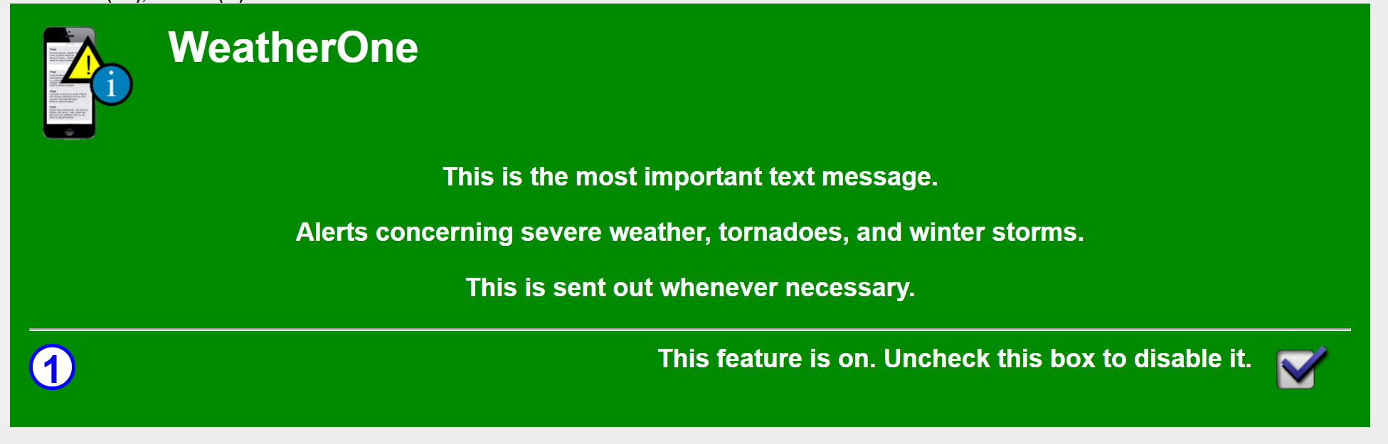
Make sure you have turned on WeatherOne. This is the app/text option for severe storms and tornadoes. You can find this under your personal notification settings in your www.weathertalk.com account.
It will look like this (green means that it is on)
.
.
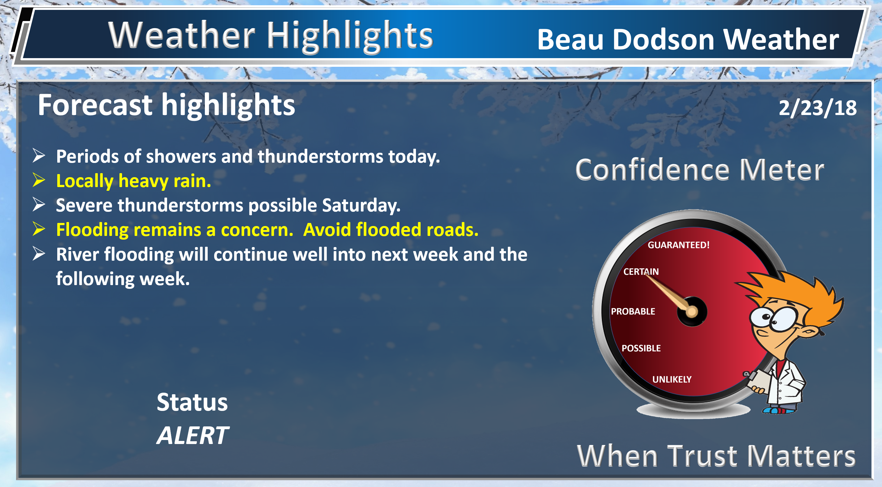
HIGHLIGHTS
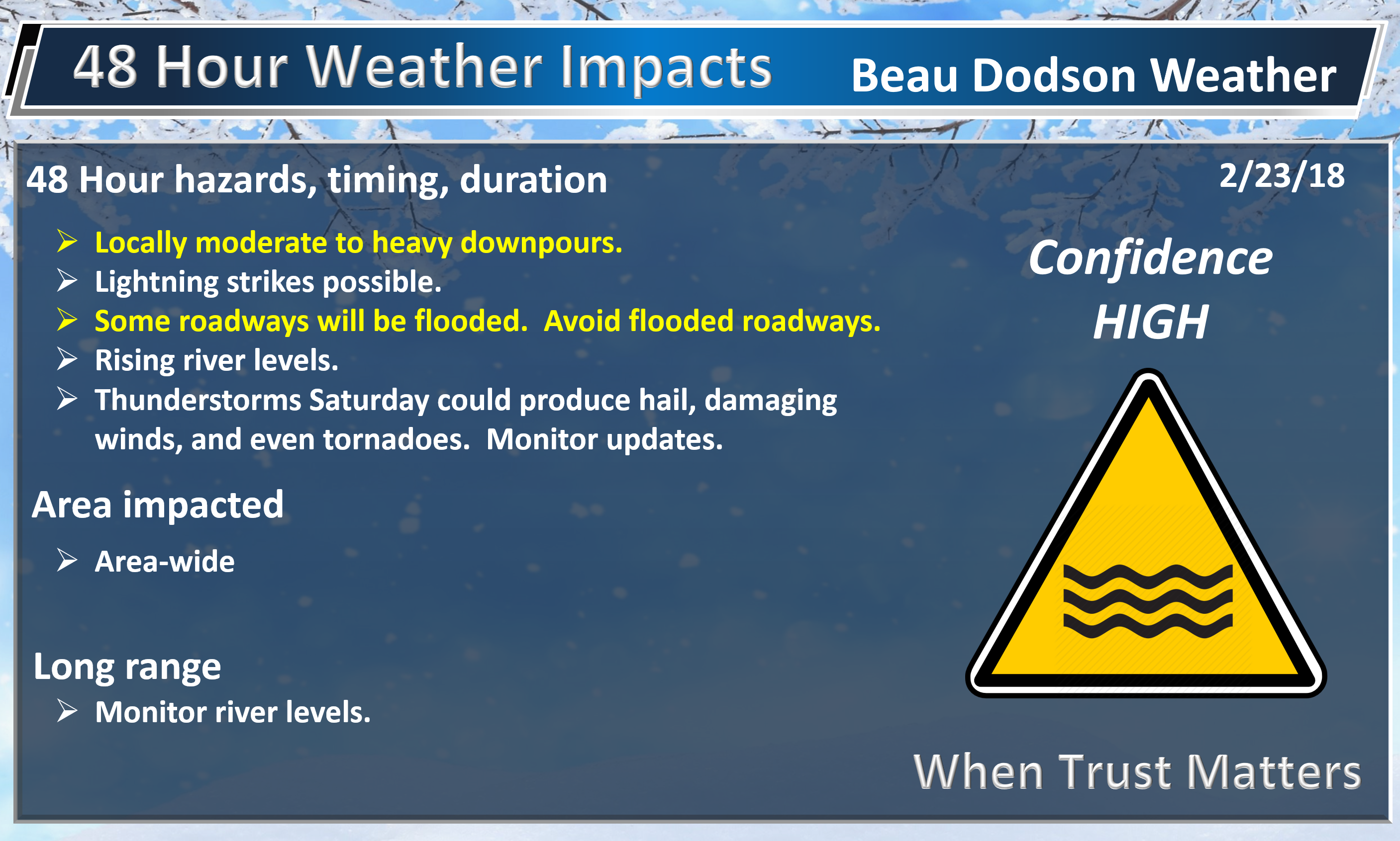
- Flash flood concerns.
- Locally heavy rain continues to be a concern into Saturday night.
- Severe thunderstorms possible Saturday afternoon and night.
- Dry Sunday! A break from the rain.
High confidence today into Friday night.
Need to check the latest river crest forecast? Click here.
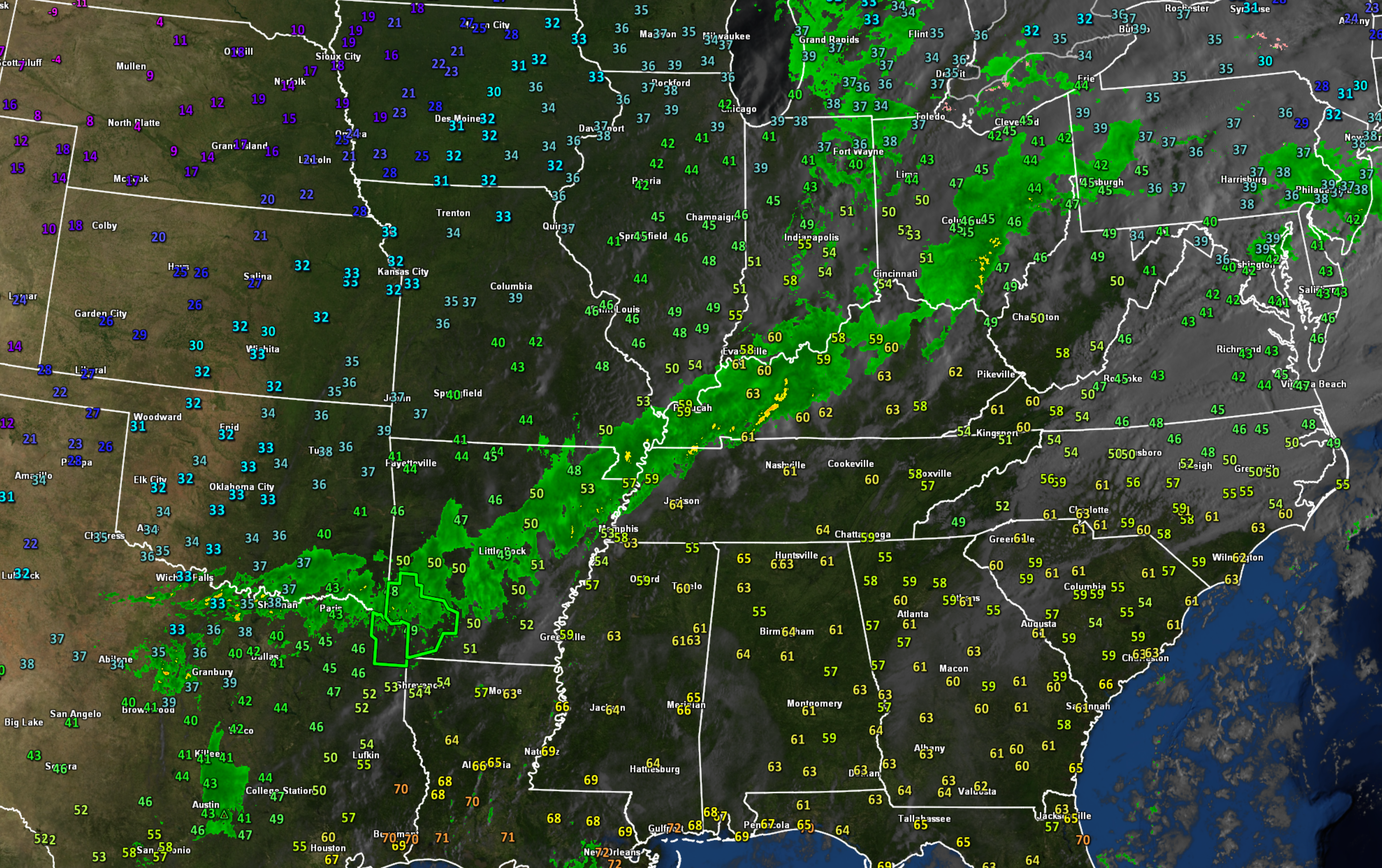
Rain rain rain rain. When will it stop?
Check out this feed of moisture on the 7:30 AM radar image.
Click image to enlarge.
.
.
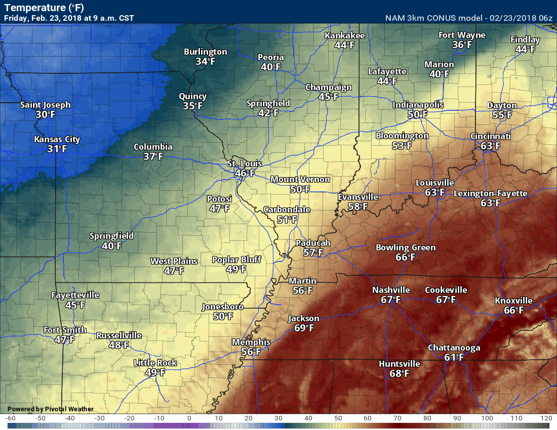
Much of the area has now received two to four inches of rain over the past few days. Some more and some less, of course. That is the way it always will be. I suppose the good news is that this hasn’t been a catastrophic ice storm event because it could have been. The map above also shows you temperatures. There is cold air behind the cold front.
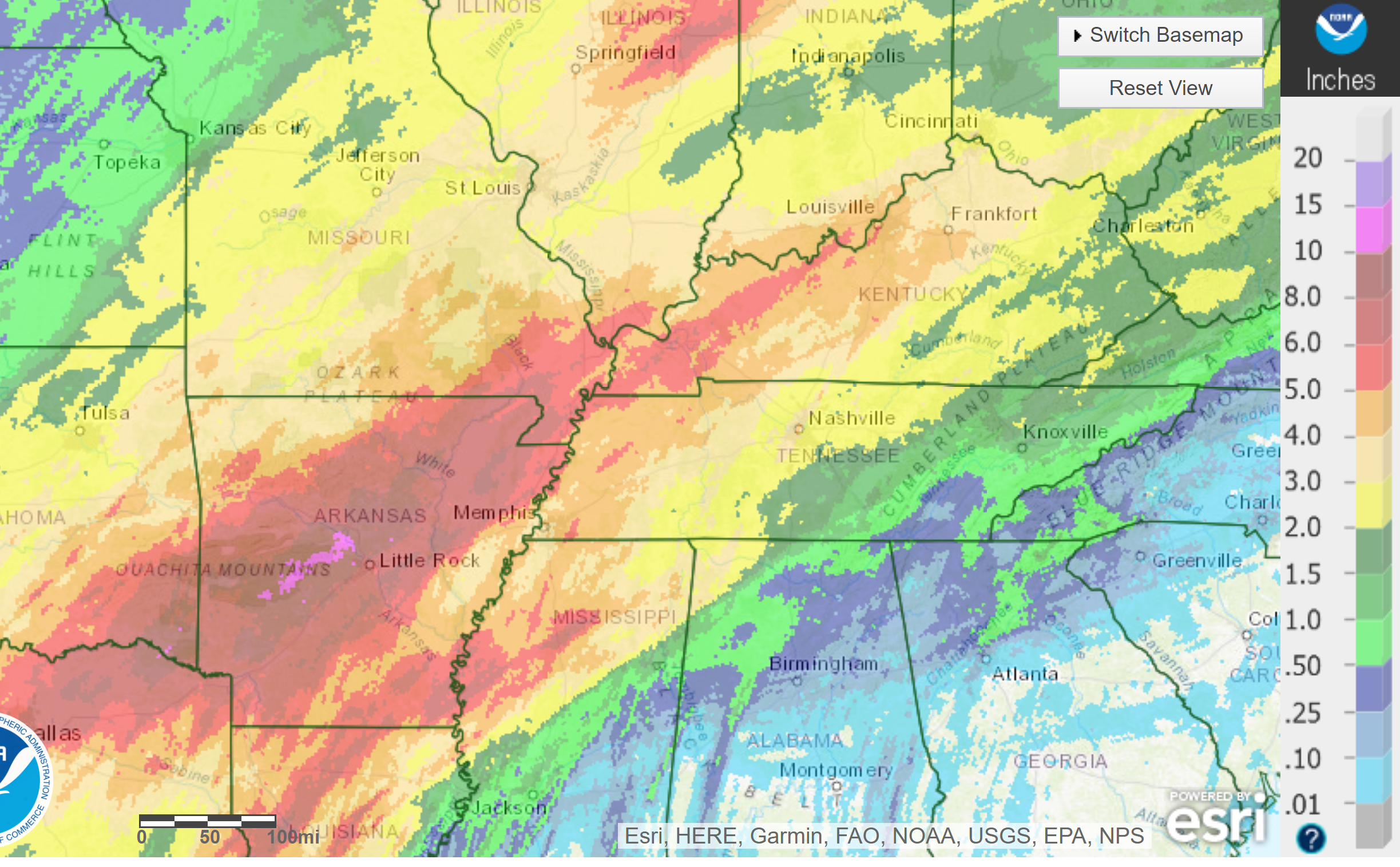
Here is how much rain has fallen. Keep in mind, these are RADAR estimated rainfall totals and not ground truth. This covers the last seven days.
Static image.
.
.
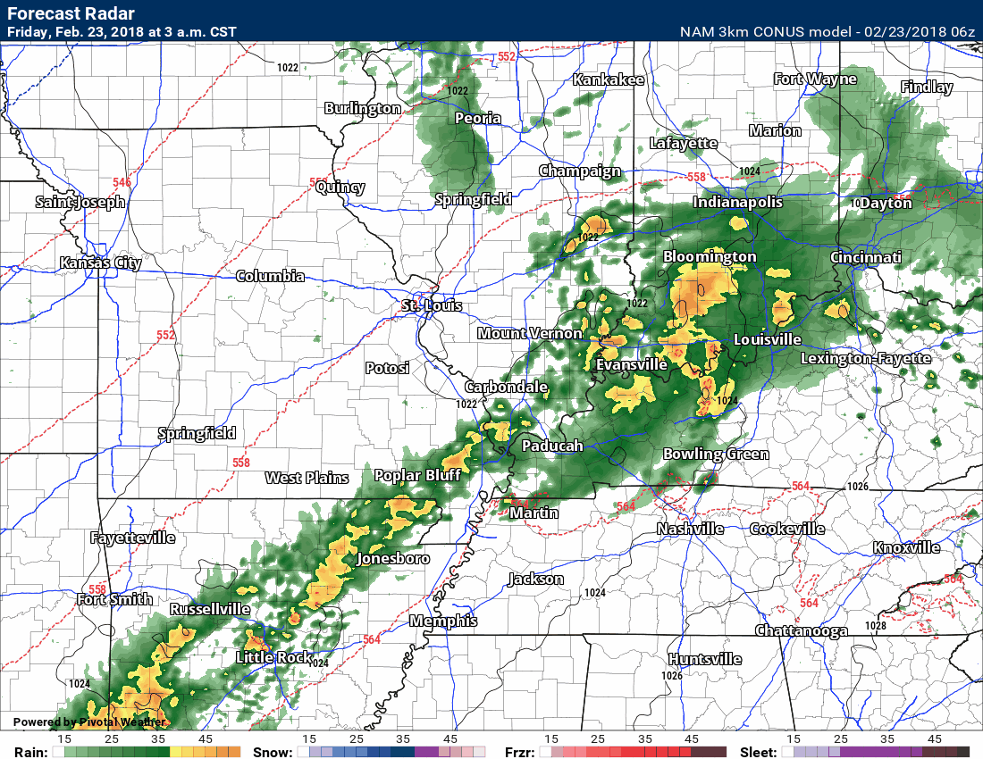
Rain will continue today but should begin to diminish in intensity. The band will intensify further west this afternoon. Here is the future-cast NAM 3K model radar. This is what radar should look like today.
Notice how the rain begins to diminish? Notice later tonight another band of moderate to possibly heavy rain moves back into the region?
Notice Saturday could produce more than one round of showers and thunderstorms. It is that last band that could produce severe weather. See the line at the end of the animation? That is the cold front sweeping eastward.
Timestamp upper left portion of the animation.
.
.
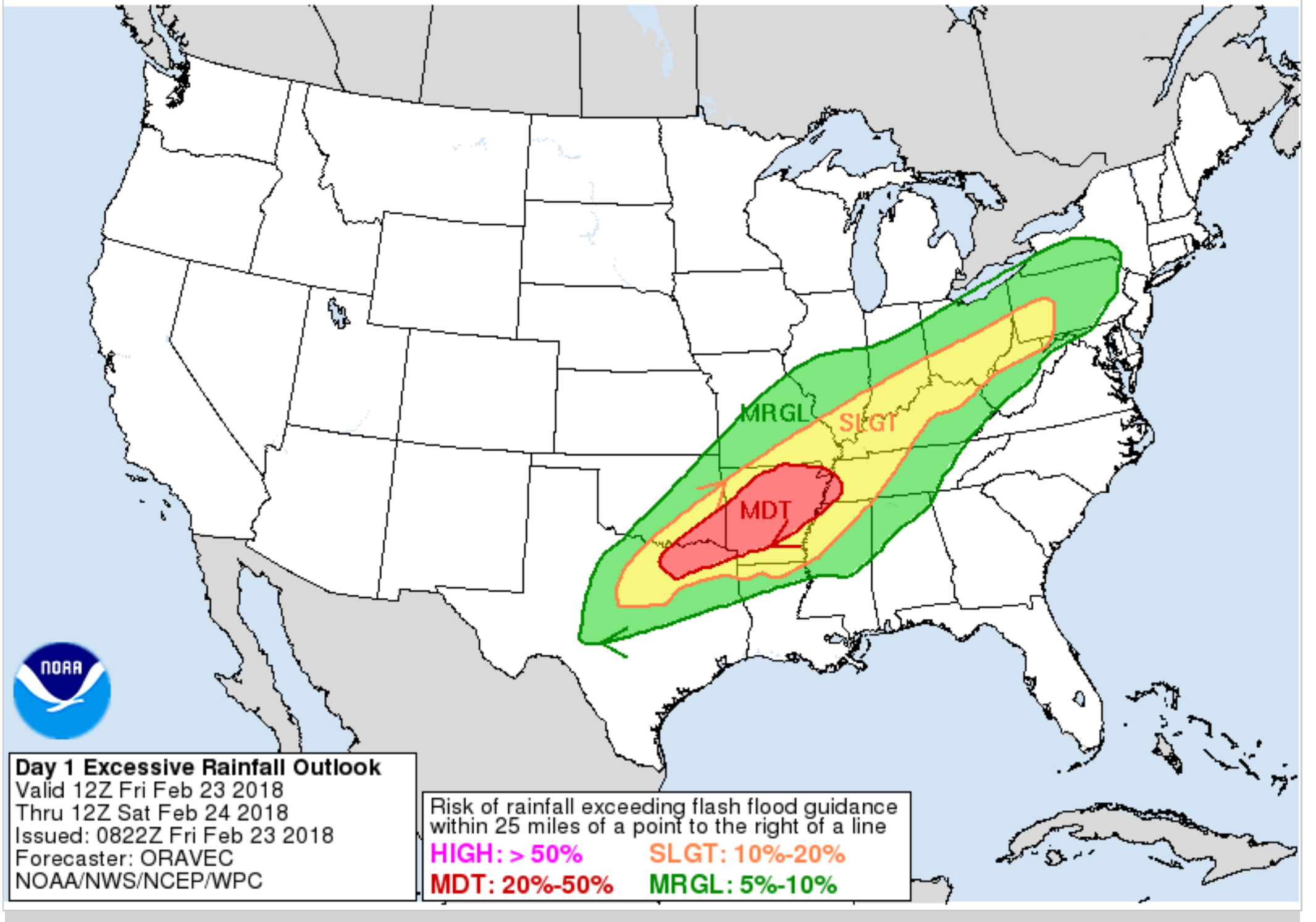
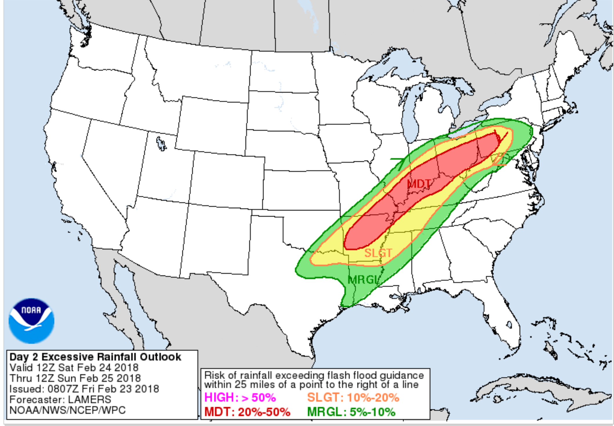
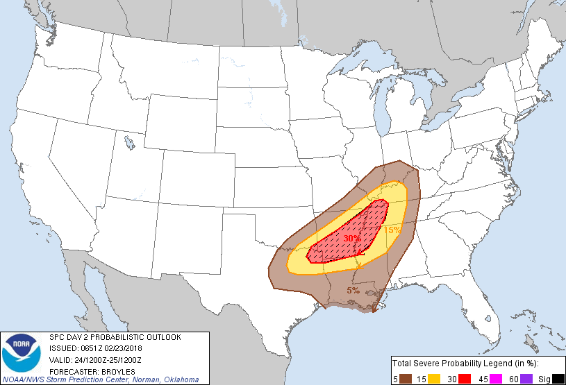
The WPC has placed us in a slight to moderate risk of flash flooding over the next 48 hours.
Today’s flash flood outlook.
.
.
Saturday’s flash flood risk zone.
.
.
Temperatures today will be milder than the last two days. That is because of a warm front passing through the area.
Here is the 3K temperature animation. You can see the milder air nudging into our region. You can also see the cooler air behind the Saturday/Saturday night cold front.
.
.
The next big discussion is the risk of severe thunderstorms as we push into Saturday afternoon and Saturday night. There are a lot of moving parts to the severe weather portion of the forecast.
Keep in mind, severe weather forecasting is fickle. Everything has to come together just right in order for a severe weather outlook to verify. It is not a perfect science. Forecasters typically don’t have a handle on what will happen until the morning of the event. There are many variables that could impact a severe weather forecast. Thus, check back for updates.
Ongoing rain and clouds could help keep instability levels lower on Saturday. That would be great news.
All of the ingredients appear to be coming together for a severe weather event Saturday afternoon and night. This event could produce some reports of damaging winds, hail, and even tornadoes.
I would recommend everyone monitor updates.
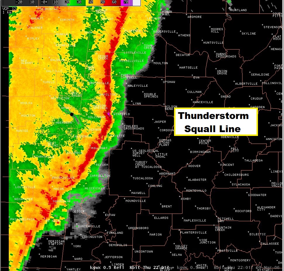
A QLCS event is the most likely scenario. I can’t rule out supercells.
Supercells are individual thunderstorms. Supercells typically produce stronger tornadoes. A QLCS event, on the other hand, is more like a squall line. A line of thunderstorms.
QLCS events can produce short-lived tornadoes. They are tricky to warn on because they can last anywhere from seconds to a few minutes. By the time a warning is issued the tornado has dissipated.
Here is what a QLCS would look like on radar. A long line of thunderstorms.
This is not tomorrow’s event. I am just giving you an example.
Tornadoes typically occur where there are kinks or notches in the line. Not always, but occasionally.
The ground is wet. That is a concern for trees if high winds occur. It would be easier to uproot trees.
.
.
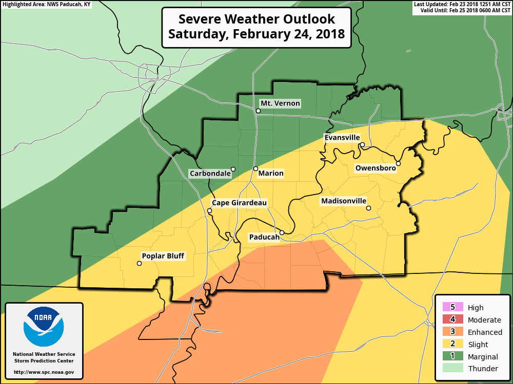
The Storm Prediction Center has outlined this area for the possibility of severe thunderstorms (mainly Saturday afternoon into Saturday night).
The light green is where lightning is possible.
The dark green is a level one out of five severe thunderstorm risk.
The yellow is a level two out of five severe thunderstorm risk.
The orange is a level three out of five severe thunderstorm risk.
The black thick line is simply the Paducah, KY National Weather Service warning area. It has nothing to do with weather.
One is the lowest risk. Five is the highest risk.
DO NOT GET CAUGHT UP ON EXACTLY WHERE THE DIFFERENT COLORS BEGIN AND END. THIS GRAPHIC WILL LIKELY NEED ADJUSTING.
.
.
They have hatched portions of the outlook. A hatched area is where a few stronger tornadoes could occur. Again, this graphic will shift around in future updates.
.
.
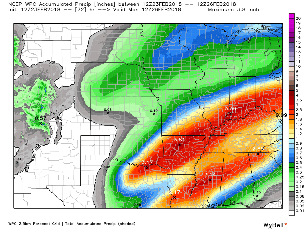
Additional heavy rain is likely over the coming days. Here is the latest WPC forecast. This covers today through Saturday night.
.
.
We typically look for four ingredients when thinking about severe thunderstorms.
- Moisture
- Instability
- Wind shear
- Lift
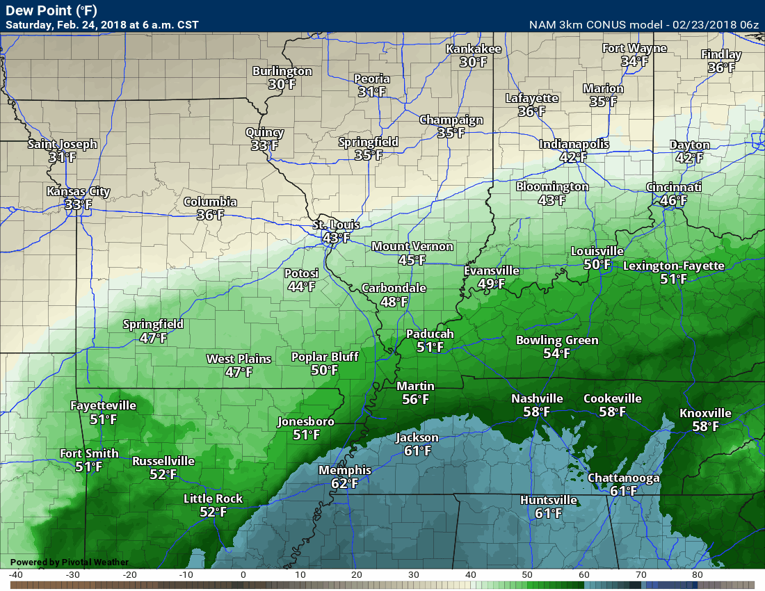
I normally look for dew points of 60 degrees and above. Here is the dew point forecast for Saturday. I will put this in motion.
Dew points will be in the 60’s ahead of the cold front. Plenty of fuel for thunderstorms.
Timestamp upper left portion of the graphic.
.
.
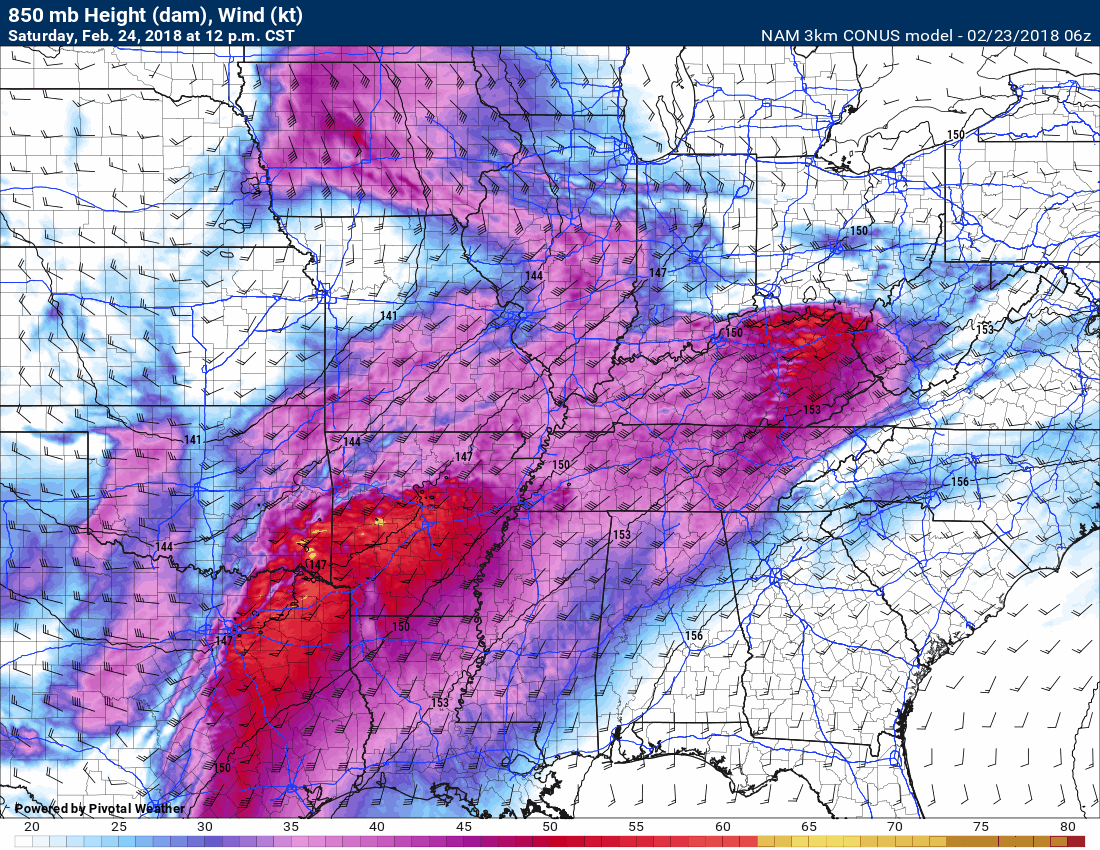
Let me show you an animation of the 850 MB winds ( a couple of thousand feet above us). Again, this is the low-level jet stream that will help fuel thunderstorms. These strong winds also create wind shear. Wind shear is one ingredient when thinking about severe weather.
The yellow and orange colors represent very strong low-level winds.
.
.
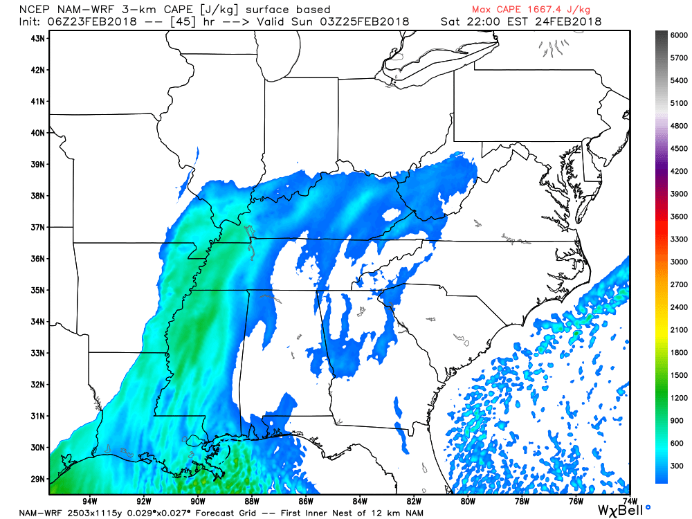
CAPE is a measure of energy in the atmosphere. Thunderstorms use this energy. Want to learn more about CAPE? Click here.
We will have CAPE/energy on Saturday. The question is how much CAPE will there be?
This is 9 PM Saturday. You can see CAPE building in from the south. Those colors represent CAPE. For this time of the year, that is sufficient CAPE for severe thunderstorms.
We will need to monitor the timing of the event. The later into the night we move the less CAPE there will be. Less CAPE would be good.
.
.
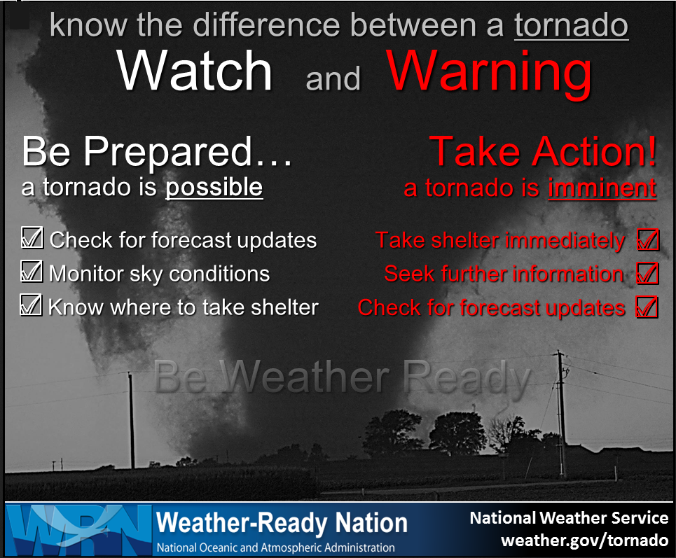
Monitor updates Saturday. A watch means to be aware. A warning means to seek shelter. Storms will be moving fast. You may not have much time to take action.
.
.
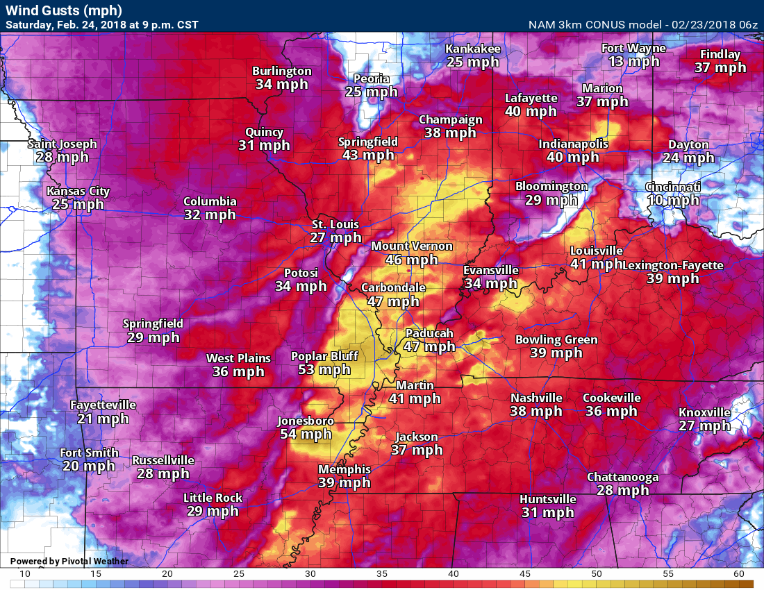
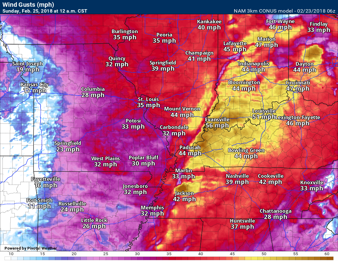
Strong winds are also possible Saturday afternoon into Sunday morning (early). These numbers are associated with the line of thunderstorms. Winds of forty to sixty mph will be possible.
9 PM Saturday wind gust map (this won’t be exact, but I am giving you a general idea of what the model is showing)
.
.
Sunday 12 AM wind gust map.
.
.
We will need to monitor river stages. Rivers are going to rise over the coming weeks.
.

.
The preliminary spring and summer forecast has been posted on the subscription website. Subscribe at www.beaudodsonweather.com
Spring and Summer outlook – Click here
.


We offer regional radars and local city radars – if a radar does not update then try another one. Occasional browsers need their cache cleared. You may also try restarting your browser. This will usually fix any problems.
During the winter you can track snow and ice by clicking the winterize button on the local city view interactive radars.
You may email me at beaudodson@usawx.com
Interactive Weather Radar Page. Choose the city nearest your location: Click this link
National interactive radar: Click this link.