This is what you are missing out on if you are not a $3 a month subscriber!
- Daily forecast texts from my computer to your app/cell phone
- Severe weather app/text alerts from my keyboard to your app/cell phone
- Social media links sent directly to your app/cell phone. When I update the blog, videos, or Facebook you will receive the link.
- Missouri Valley centered video updates
- Ohio Valley centered video updates
- Long-range video updates
- Week one temperature and precipitation outlook
- Week two temperature and precipitation outlook
- Week three and four temperature and precipitation outlook
- Monthly outlooks
Monthly operating costs for Weather Talk can top $2000.00. Your $3 subscription helps pay for those costs. I work for you.
.

.
Your $3 per month also helps support these local charity projects.
.

.

.
Interactive Weather Radar Page. Choose the city nearest your location: Click this link.
We offer regional radars and local city radars – if a radar does not update then try another one. Occasional browsers need their cache cleared. You may also try restarting your browser. This will usually fix any problems.
During the winter you can track snow and ice by clicking the winterize button on the local city view interactive radars.
.

.
February 22, 2018
Thursday Forecast Details
Forecast: A flood watch is in effect through Saturday night. Partly to mostly cloudy. Patchy drizzle or showers during the day. It may be mostly dry today. Rain chances will begin to increase as we move into this evening.
Temperatures: MO ~ 46 to 54 IL ~ 46 to 54 KY ~ 54 to 58
What is the chance of precipitation? MO ~ 30% IL ~ 30% KY ~ 30% TN ~ 30%
Coverage of precipitation: Patchy or widely scattered
Wind chill values: N/A
Accumulating snow or ice: No
Winds: North and northeast at 7 to 14 mph
What impacts are anticipated from the weather? Wet roadways.
My confidence in the forecast verifying: High
Is severe weather expected? No
The NWS defines severe weather as 58 mph wind or great, 1″ hail or larger, and/or tornadoes
Should I cancel my outdoor plans? Have a plan B and monitor radars
.
Thursday Night Forecast Details:
Forecast: Cloudy. Rain re-developing area-wide. Thunderstorms possible. Temperatures steady or slowly rising.
Temperatures: MO ~ 42 to 50 IL ~ 44 to 50 KY ~ 52 to 56
What is the chance of precipitation? MO ~ 80% IL ~ 80% KY ~ 70% TN ~ 70%
Coverage of precipitation: Increasing coverage overnight. Becoming widespread.
Wind chill values: 40’s
Accumulating snow or ice: No
Winds: East and northeast winds at 6 to 12 mph. Winds becoming south and southeast.
What impacts are anticipated from the weather? Wet roadways. Lightning. Locally heavy rain.
My confidence in the forecast verifying: High
Is severe weather expected? No
The NWS defines severe weather as 58 mph wind or great, 1″ hail or larger, and/or tornadoes
Should I cancel my outdoor plans: Have a plan B
.
A flood watch is in effect through Saturday night.
February 23, 2018
Friday Forecast Details
Forecast: Cloudy. Rain likely. Thunderstorms possible. Locally heavy rain.
Temperatures: MO ~ 56 to 62 IL ~ 56 to 60 KY ~ 60 to 65
What is the chance of precipitation? MO ~ 70% IL ~ 70% KY ~ 70% TN ~ 70%
Coverage of precipitation: Widespread
Wind chill values: N/A
Accumulating snow or ice: No
Winds: Variable at 7 to 14 mph with gusts to 18 mph
What impacts are anticipated from the weather? Wet roadways. Lightning. Locally heavy rain.
My confidence in the forecast verifying: High
Is severe weather expected? No
The NWS defines severe weather as 58 mph wind or great, 1″ hail or larger, and/or tornadoes
Should I cancel my outdoor plans? Have a plan B
.
Friday Night Forecast Details:
Forecast: Cloudy. Showers and thunderstorms possible. Locally heavy rain.
Temperatures: MO ~ 48 to 54 IL ~ 46 to 55 KY ~54 to 60
What is the chance of precipitation? MO ~ 70% IL ~ 70% KY ~ 70% TN ~ 70%
Coverage of precipitation: Widespread.
Wind chill values: N/A
Accumulating snow or ice: No
Winds: Northeast and east at 5 to 10 mph with gusts to 16 mph
What impacts are anticipated from the weather? Wet roadways. Lightning. Locally heavy rain.
My confidence in the forecast verifying: Medium
Is severe weather expected? No
The NWS defines severe weather as 58 mph wind or great, 1″ hail or larger, and/or tornadoes
Should I cancel my outdoor plans? Have a plan B
.
February 24, 2018
Saturday Forecast Details
Forecast: Partly to mostly cloudy. Warm. Windy. Periods of showers and thunderstorms. A few storms could be severe during the afternoon hours. Locally heavy rain.
Temperatures: MO ~ 64 to 68 IL ~ 64 to 68 KY ~65 to 70
What is the chance of precipitation? MO ~ 70% IL ~ 70% KY ~ 70% TN ~ 70%
Coverage of precipitation: Numerous
Wind chill values: N/A
Accumulating snow or ice: No
Winds: South and southeast at 14 to 28 mph with higher gusts
What impacts are anticipated from the weather? Wet roadways. Lightning. Heavy rain. Some severe storms possible.
My confidence in the forecast verifying: High
Is severe weather expected? Severe thunderstorms are possible during the afternoon. Monitor updates.
The NWS defines severe weather as 58 mph wind or great, 1″ hail or larger, and/or tornadoes
Should I cancel my outdoor plans? Have a plan B
.
Saturday Night Forecast Details:
Forecast: Cloudy. Showers and thunderstorms in the evening. Some storms could be intense. Locally heavy rain. Precipitation ending overnight from west to east. Turning colder.
Temperatures: MO ~ 38 to 44 IL ~ 40 to 45 KY ~ 42 to 46
What is the chance of precipitation? MO ~ 70% IL ~ 70% KY ~ 70% TN ~ 70%
Coverage of precipitation: Numerous, especially the first half of the night.
Wind chill values: N/A
Accumulating snow or ice: No
Winds: South winds at 6 to 12 mph with gusts to 20 mph. Winds becoming west and northwest at 10 to 20 mph.
What impacts are anticipated from the weather? Wet roadways. Lightning. Heavy rain. A few storms could be severe.
My confidence in the forecast verifying: Medium
Is severe weather expected? Severe thunderstorms are possible.
The NWS defines severe weather as 58 mph wind or great, 1″ hail or larger, and/or tornadoes
Should I cancel my outdoor plans: Have a plan B
February 25, 2018
Sunday Forecast Details
Forecast: Partly sunny. Cool.
Temperatures: MO ~ 54 to 58 IL ~ 54 to 58 KY ~ 54 to 58
What is the chance of precipitation? MO ~ 0% IL ~ 0% KY ~ 0% TN ~ 0%
Coverage of precipitation: None
Wind chill values: N/A
Accumulating snow or ice: No
Winds: West and northwest at 8 to 16 mph
What impacts are anticipated from the weather? None
My confidence in the forecast verifying: High
Is severe weather expected? No
The NWS defines severe weather as 58 mph wind or great, 1″ hail or larger, and/or tornadoes
Should I cancel my outdoor plans? No
.
Sunday Night Forecast Details:
Forecast: Mostly clear. A few passing clouds. Patchy fog.
Temperatures: MO ~ 35 to 40 IL ~ 35 to 40 KY ~ 36 to 42
What is the chance of precipitation? MO ~ 0% IL ~ 0% KY ~ 0% TN ~ 0%
Coverage of precipitation: None
Wind chill values: N/A
Accumulating snow or ice: No
Winds: North 5 mph with gusts to 10 mph
What impacts are anticipated from the weather? None
My confidence in the forecast verifying: High
Is severe weather expected? No
The NWS defines severe weather as 58 mph wind or great, 1″ hail or larger, and/or tornadoes
Should I cancel my outdoor plans: No
.
February 26, 2018
Monday Forecast Details
Forecast: Partly sunny.
Temperatures: MO ~ 54 to 58 IL ~ 54 to 58 KY ~ 54 to 58
What is the chance of precipitation? MO ~ 0% IL ~ 0% KY ~ 0% TN ~ 0%
Coverage of precipitation: None
Wind chill values: N/A
Accumulating snow or ice: No
Winds: East and northeast at 5 to 10 mph
What impacts are anticipated from the weather? None
My confidence in the forecast verifying: High
Is severe weather expected? No
The NWS defines severe weather as 58 mph wind or great, 1″ hail or larger, and/or tornadoes
Should I cancel my outdoor plans? No
.
Monday Night Forecast Details:
Forecast: A few passing clouds. Cool. Patchy fog.
Temperatures: MO ~ 34 to 38 IL ~ 34 to 38 KY ~ 34 to 38
What is the chance of precipitation? MO ~ 0% IL ~ 0% KY ~ 0% TN ~ 0%
Coverage of precipitation: None
Wind chill values: N/A
Accumulating snow or ice: No
Winds: North and northeast 5 mph
What impacts are anticipated from the weather? None
My confidence in the forecast verifying: High
Is severe weather expected? No
The NWS defines severe weather as 58 mph wind or great, 1″ hail or larger, and/or tornadoes
Should I cancel my outdoor plans: No
.
February 27, 2018
Tuesday Forecast Details
Forecast: Mostly sunny. Mild.
Temperatures: MO ~ 58 to 62 IL ~ 58 to 62 KY ~ 58 to 62
What is the chance of precipitation? MO ~ 0% IL ~ 0% KY ~ 0% TN ~ 0%
Coverage of precipitation: None
Wind chill values: N/A
Accumulating snow or ice: No
Winds: East and southeast at 5 to 10 mph
What impacts are anticipated from the weather? None
My confidence in the forecast verifying: Medium
Is severe weather expected? No
The NWS defines severe weather as 58 mph wind or great, 1″ hail or larger, and/or tornadoes
Should I cancel my outdoor plans? No
.
Tuesday Night Forecast Details:
Forecast: Increasing clouds. A chance of showers late.
Temperatures: MO ~ 42 to 46 IL ~ 42 to 46 KY ~ 42 to 46
What is the chance of precipitation? MO ~ 30% IL ~ 30% KY ~ 30% TN ~ 30%
Coverage of precipitation: Scattered late
Wind chill values: N/A
Accumulating snow or ice: No
Winds: Variable at 4 to 8 mph
What impacts are anticipated from the weather? Wet roadways late.
My confidence in the forecast verifying: Medium
Is severe weather expected? No
The NWS defines severe weather as 58 mph wind or great, 1″ hail or larger, and/or tornadoes
Should I cancel my outdoor plans: No
.

.
Thursday through Sunday: Winter weather is not anticipated.
.

.
The National Weather Service definition of a severe thunderstorm is one that produces quarter size hail or larger, 58 mph winds or greater, and/or a tornado.
Thursday through Saturday morning: On and off thunderstorms chances are possible. At this time, the severe weather risk appears low. Lightning will be the main concern. Heavy rain will be a concern.
Saturday afternoon and Saturday night: Monitor updates. Severe storms are possible during this time frame.
.

.
The daily outlook can be found at the bottom of this post.
.
.
We offer regional radars and local city radars – if a radar does not update then try another one. Occasional browsers need their cache cleared. You may also try restarting your browser. This will usually fix any problems.
..
.
.
.
.
Forecast:
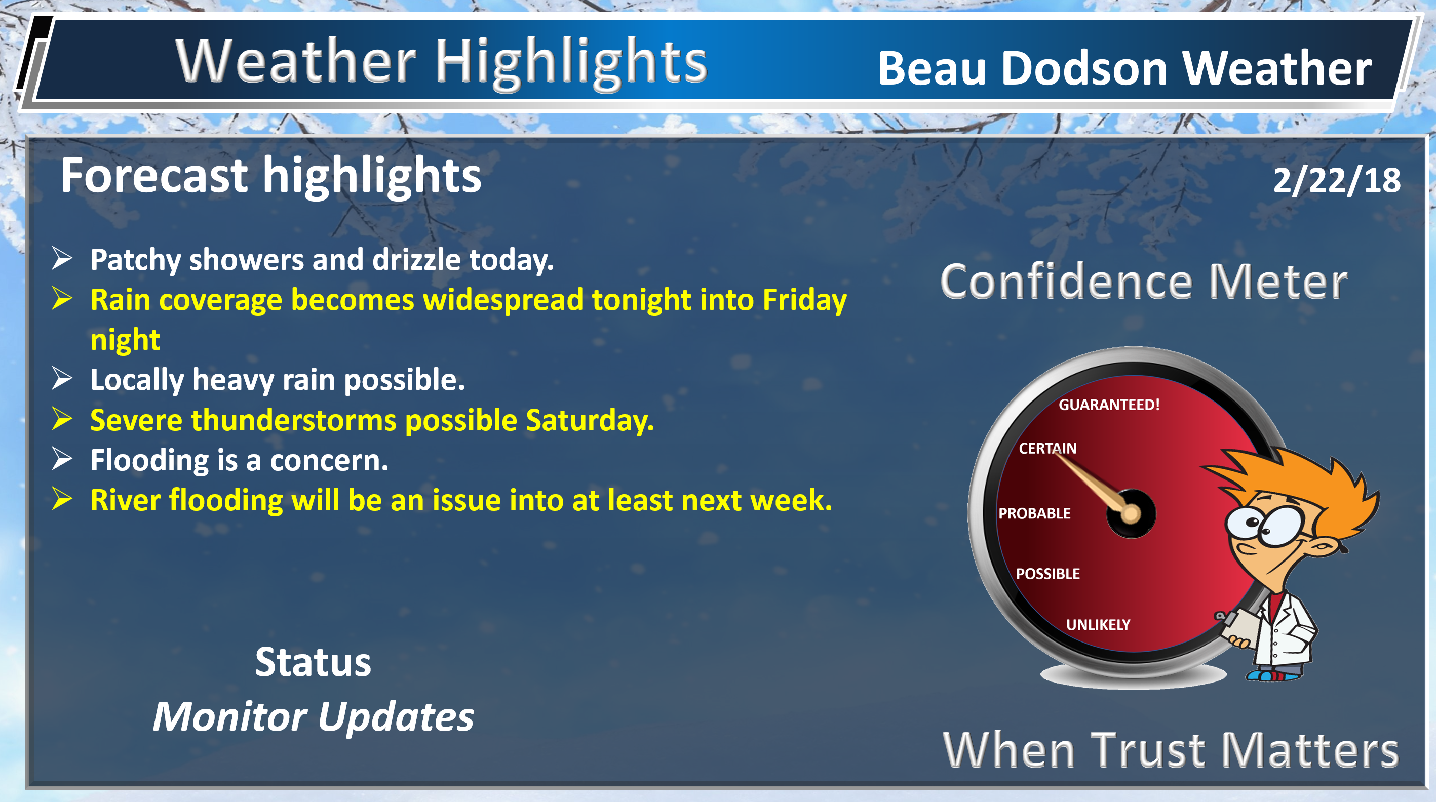
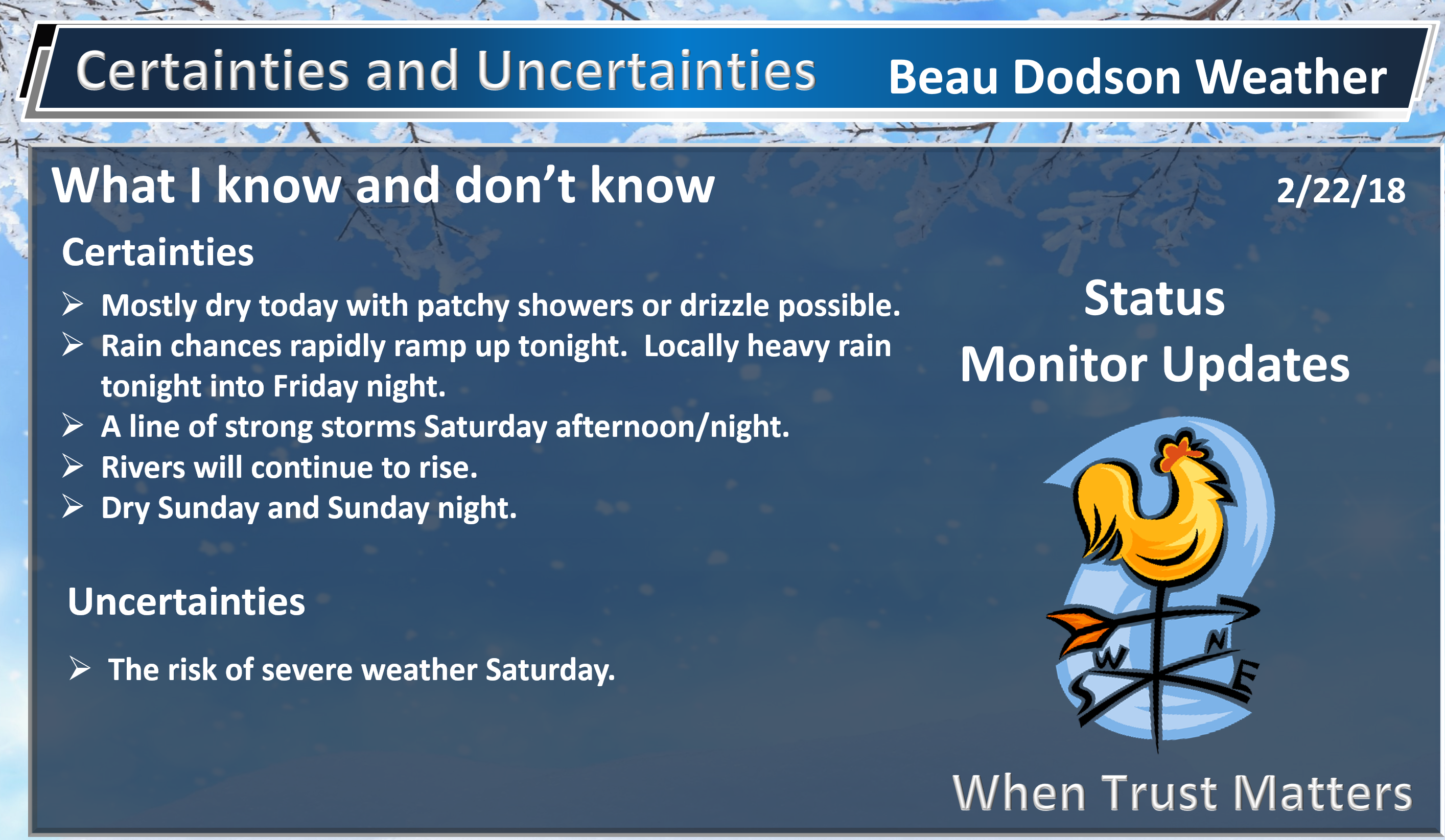
HIGHLIGHTS
- More rain.
- Locally heavy rain continues to be a concern into Saturday night.
- I am monitoring Saturday into Saturday night for strong to severe thunderstorms. Monitor updates.
- Dry Sunday! A break from the rain.
High confidence today into Friday night.
Are you tired of the rain, yet? I am!
Rainfall over the past few days has generally been in the one to three-inch range across the region. There was even some freezing rain across parts of southeast Missouri and southern Illinois on Wednesday.
The freezing rain has come to an end, but the rain has not.
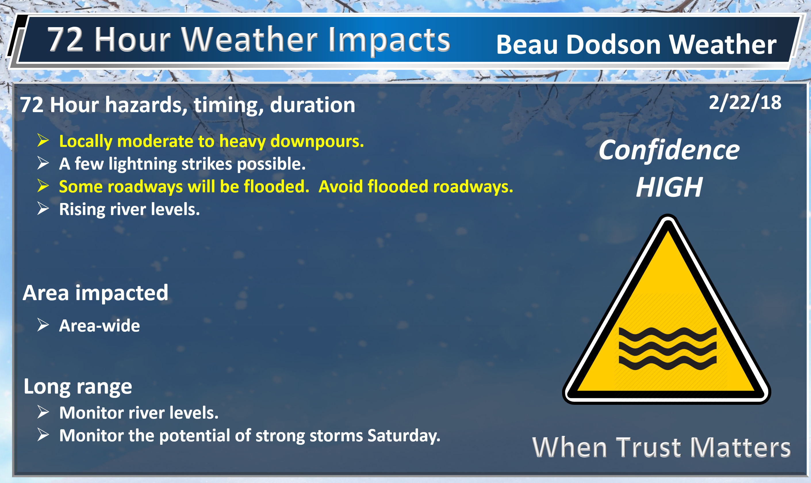
We will have scattered showers to deal with today into tonight. Better chances of rain arrive late tonight into Friday night. Some of the rain will be moderate to heavy.
There have been reports of water over roadways. Flooding is going to be a concern for several more days. Flood watches blanket the entire region. Avoid flooded roadways, as always.
Those living along rivers will want to monitor river forecast crest levels. You may check those numbers at this link. Click here.
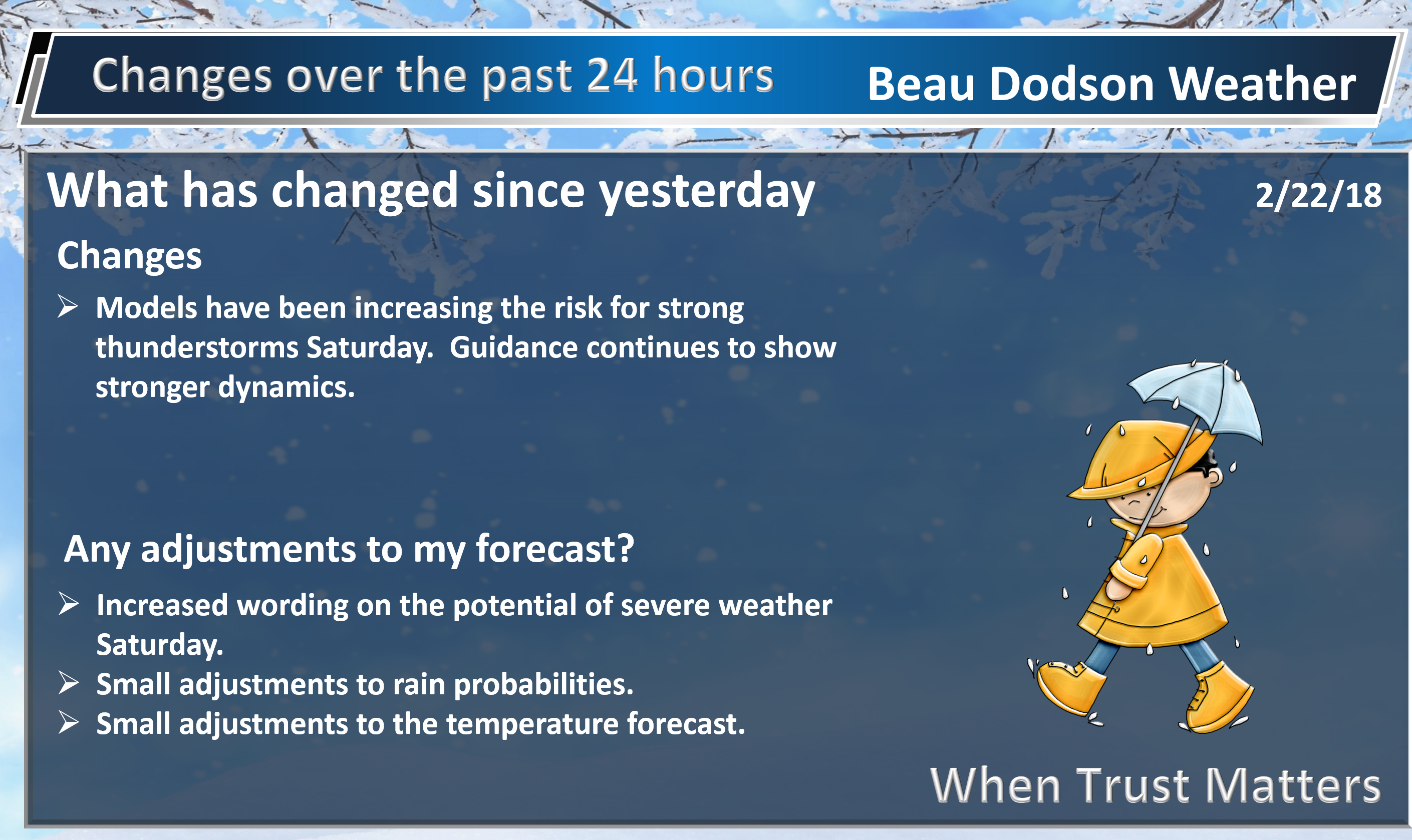
In addition to the above, I am closely monitoring Saturday into Saturday night for strong to severe thunderstorms.
Damaging winds, hail, and perhaps tornadoes will be the concern. It is not clear as to whether we will be dealing with a line of thunderstorms (QLCS) or both a line of thunderstorms and individual supercells.
There will be clouds and rain to deal with Friday night into Saturday morning. This raises questions about instability levels.
If clouds clear and we heat up a bit then severe thunderstorms chances will increase.
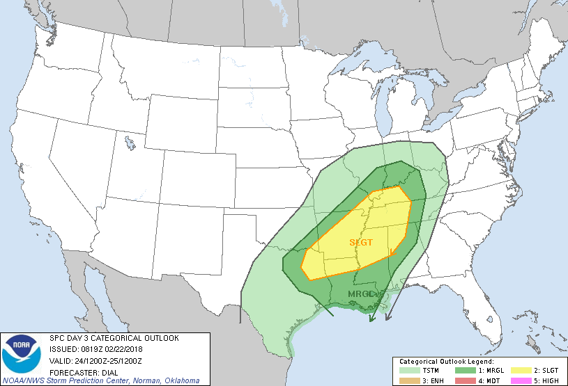
The Storm Prediction Center has outlined this area in dark green and yellow for the possibility of severe storms Saturday afternoon and night. This will shift around. Monitor updates, as always.
Dark green is a level one out of five risk. Yellow is a level two out five risk. One is the lower risk and five is the highest risk.
They may need to increase these levels. There remain some questions about CAPE/energy/instability levels.
.
.
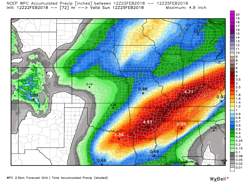
Additional heavy rain is likely over the coming days. Here is the latest WPC forecast. This covers today through Saturday night.
.
.
We typically look for four ingredients when thinking about severe thunderstorms.
- Moisture
- Instability
- Wind shear
- Lift
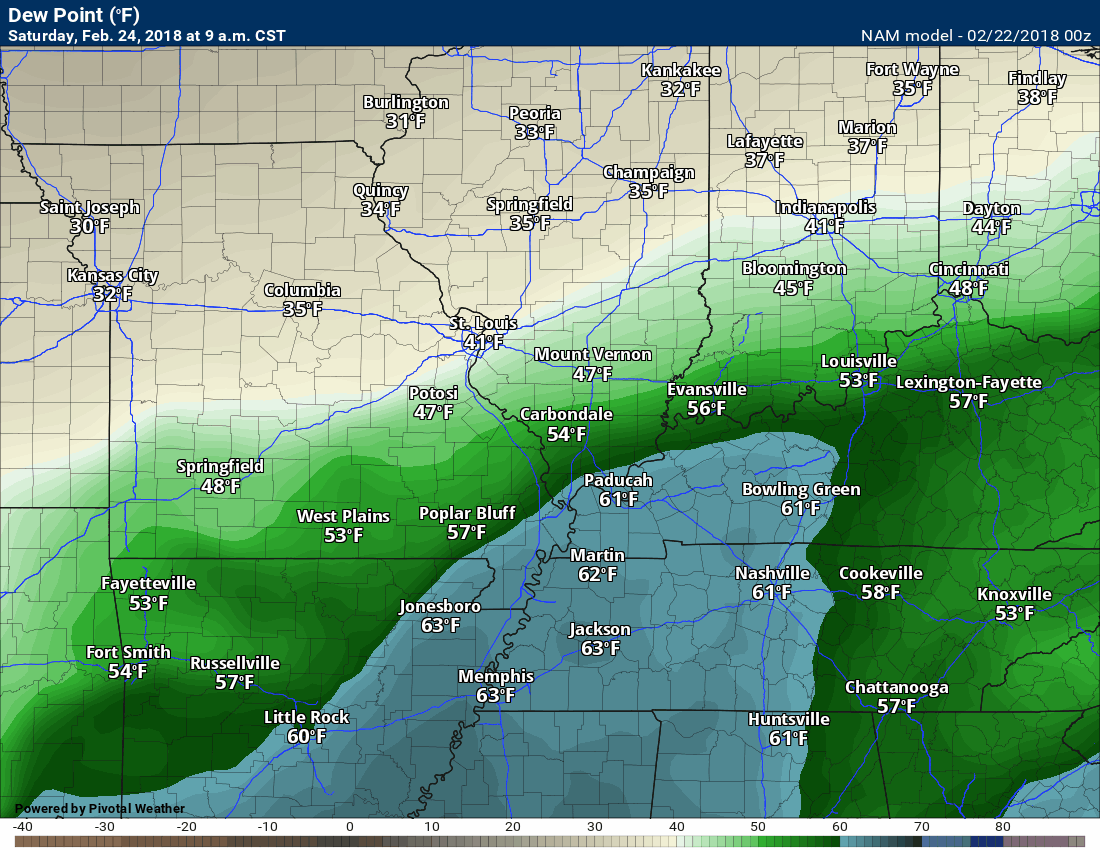
I normally look for dew points of 60 degrees and above. Here is the dew point forecast for Saturday. I will put this in motion.
Dew points will be in the 60’s ahead of the cold front. Plenty of fuel for thunderstorms.
Timestamp upper left portion of the graphic.
.
.
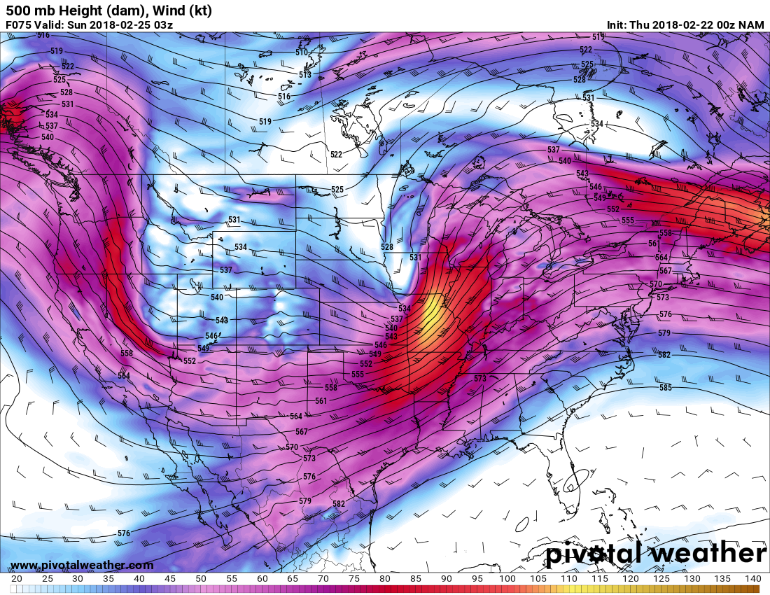
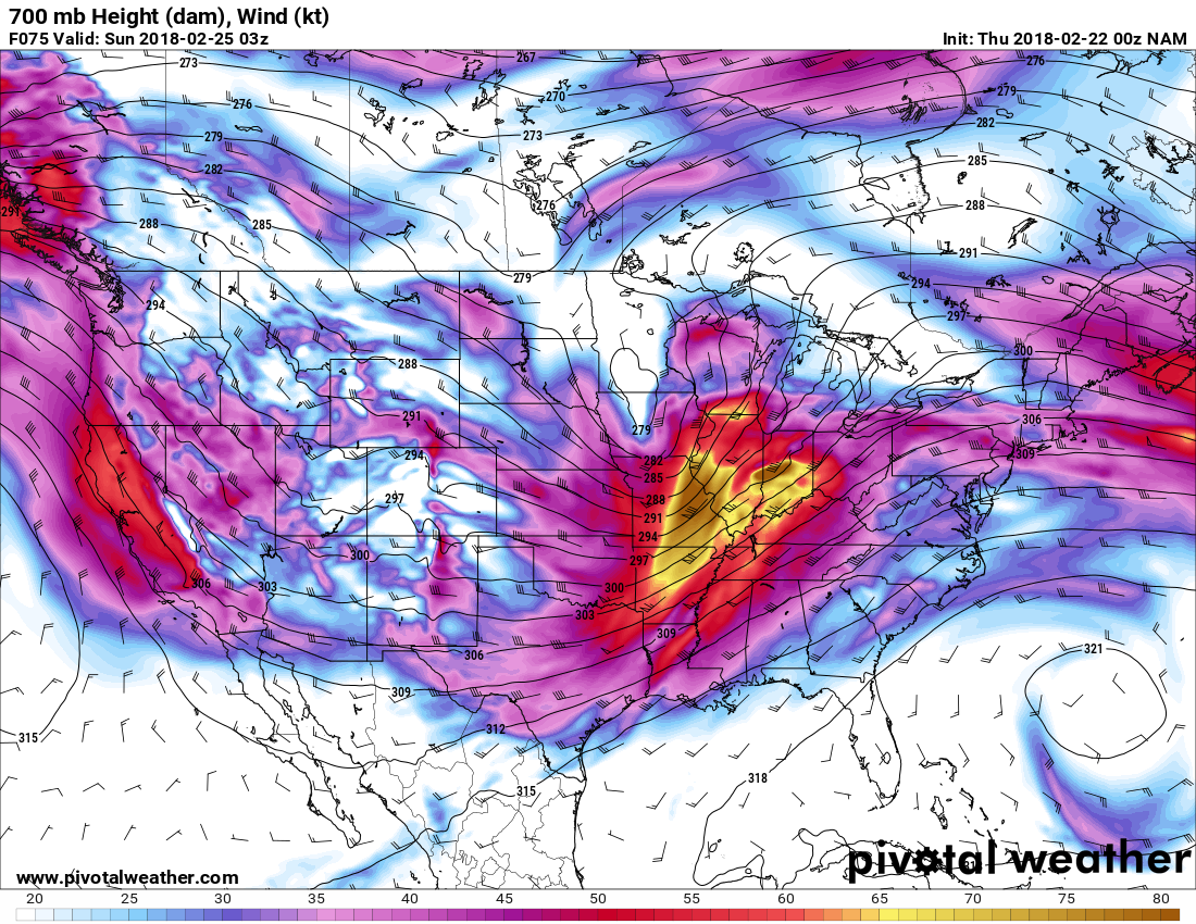
Let’s take a look at lift.
Here are the upper-level wind maps. These maps show you low level jets, jet streams, and jet streaks. Basically, winds thousands of feet above our heads.
500 mb level. Strong jet streak moving through our region. Those are 100 to 115-knot winds in the yellow (at the 500 mb level)
.
.
700 mb level. Powerful winds at the 700 mb level, as well. Divergence over Illinois indicates considerable lift.
.
.
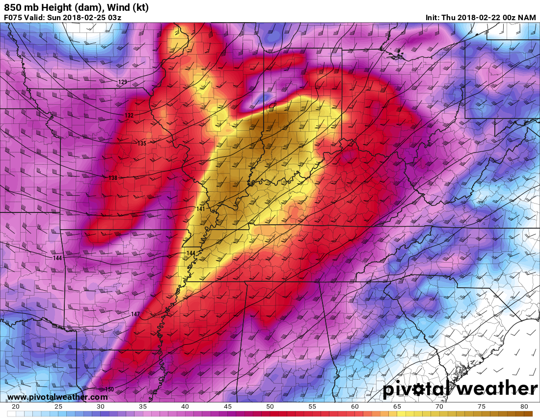
Impressive 850 mb winds. Low-level jet stream. These are strong low level winds a couple thousand feet aloft. This can result in wind damage if thunderstorms tap into those winds.
.
.
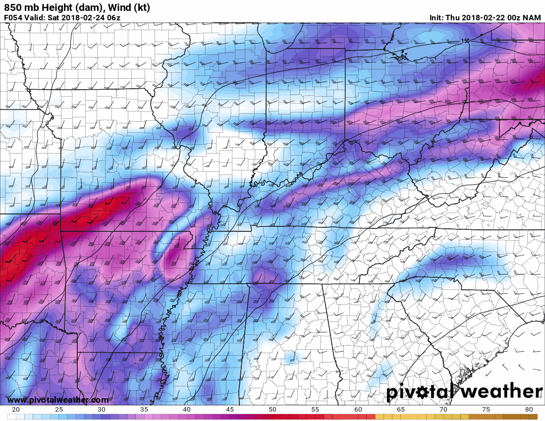
Let me show you an animation of the 850 mb winds. Again, this is the low-level jet stream that will help fuel thunderstorms. These strong winds also create wind shear. Wind shear is one ingredient when thinking about severe weather.
.
.
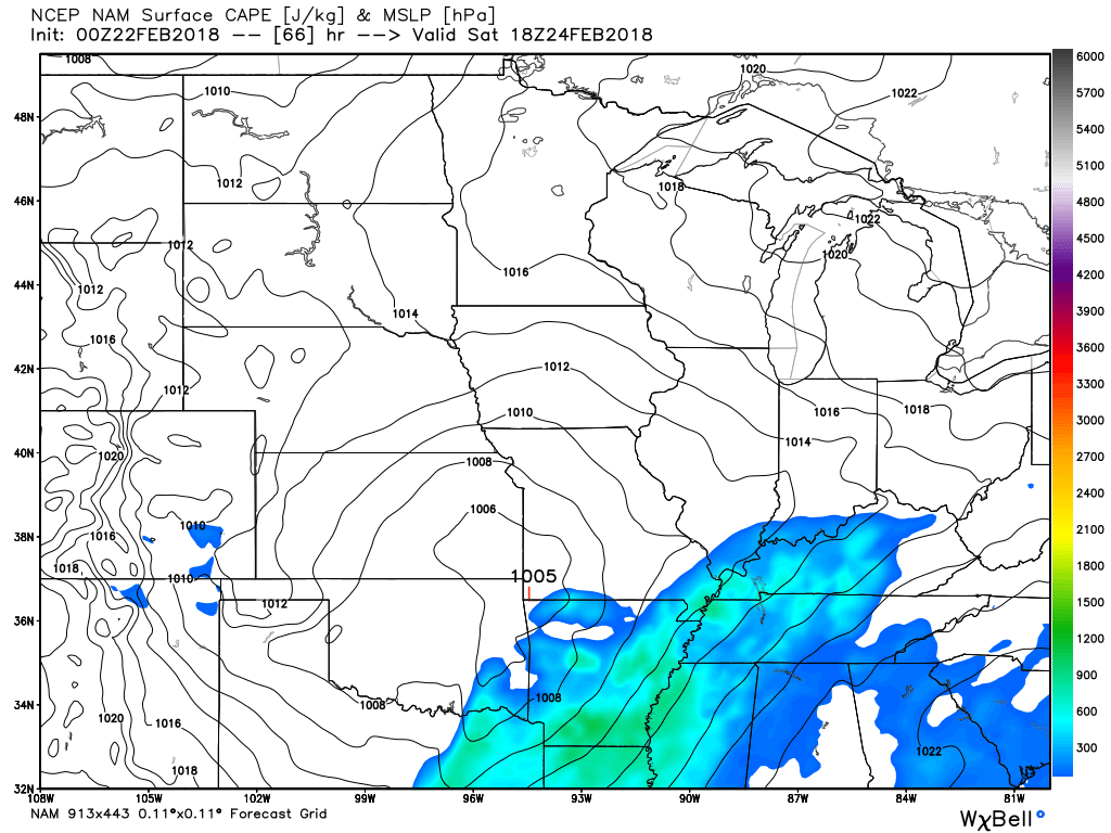
CAPE is a measure of energy in the atmosphere. Thunderstorms use this energy. Want to learn more about CAPE? Click here.
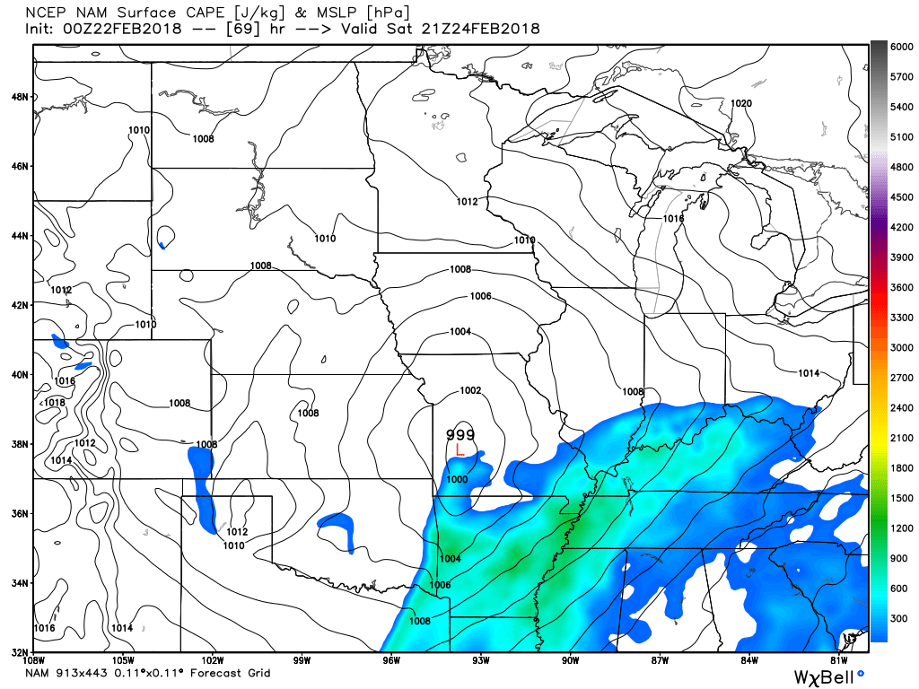
We will have CAPE/energy on Saturday. The question is how much CAPE will there be?
This is 12 PM Saturday. You can see CAPE building in from the south. Those colors represent CAPE. For this time of the year, that is sufficient CAPE for severe thunderstorms.
.
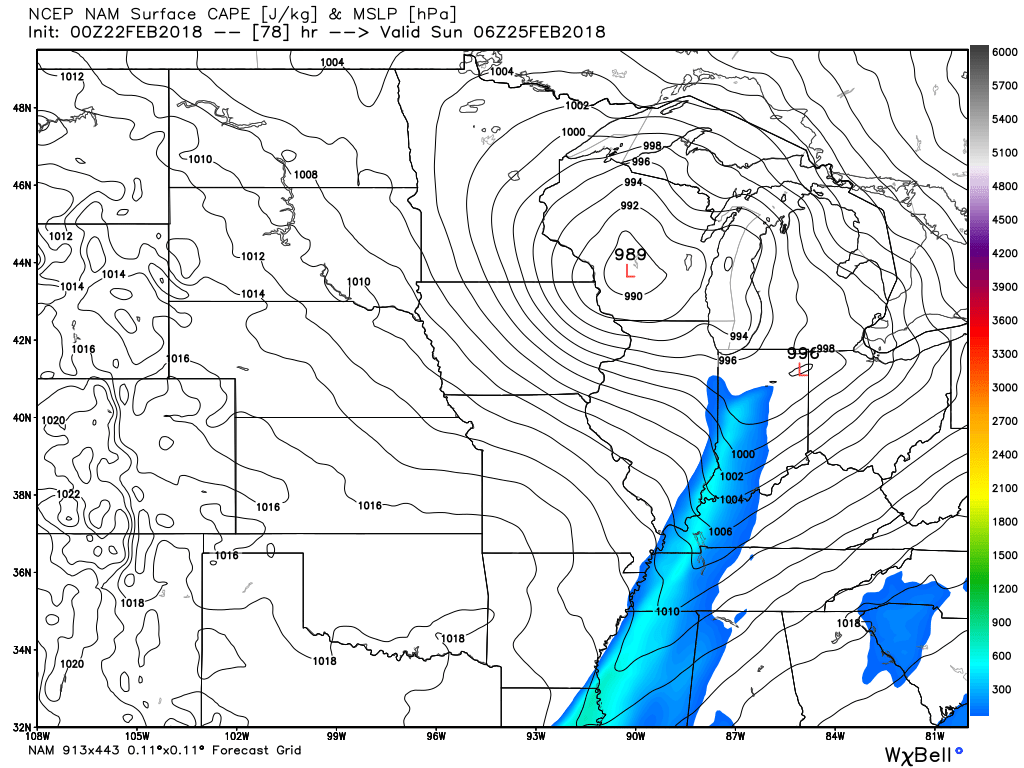
3 PM Saturday
6 PM Saturday
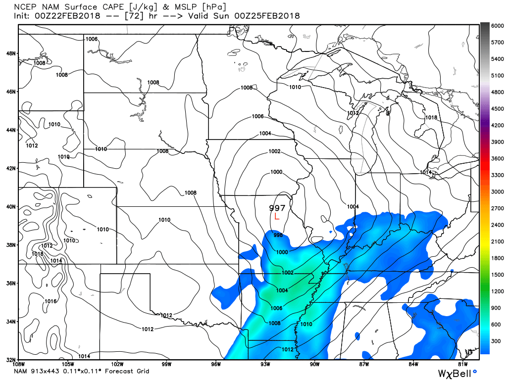
9 PM Saturday
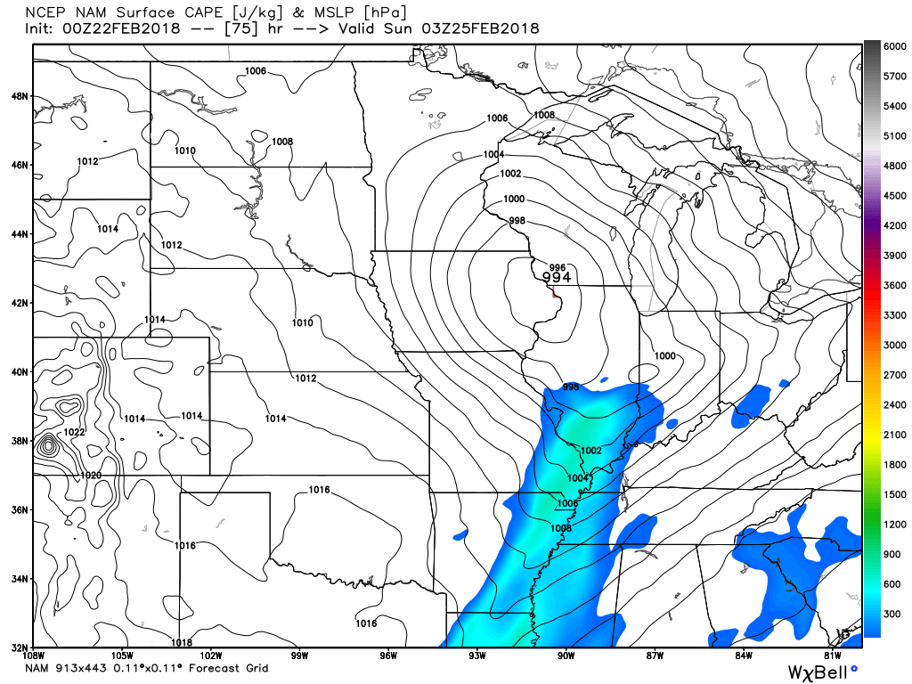
12 AM Sunday (CAPE is waning and the front is pushing off to the east)
.
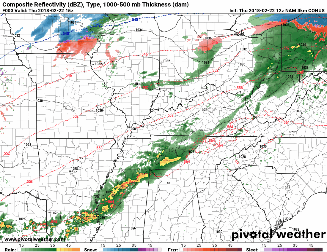
Let’s take a look at a future-cast radar animation.
Green and yellow/orange represent rain. Blue is snow. Purple, pink, and red represent freezing rain.
This model is the high-resolution 3K NAM.
This is one model’s opinion. Other models may disagree. Model’s are for guidance and are not gospel. Typically, no one model is 100% correct. It normally takes a blend of model guidance to put together a forecast.
This does not cover the entire event on Saturday. This takes us out to 3 PM Saturday.
The NAM has quite a bit of rain and clouds Saturday. This could lessen instability levels. This remains a question. Less instability would mean less of a severe weather risk.
.
.
We will need to monitor river stages. Rivers are going to rise over the coming weeks.
.

.
The preliminary summer forecast has been posted on the subscription website. Subscribe at www.beaudodsonweather.com
Summer outlook – Click here
.


We offer regional radars and local city radars – if a radar does not update then try another one. Occasional browsers need their cache cleared. You may also try restarting your browser. This will usually fix any problems.
During the winter you can track snow and ice by clicking the winterize button on the local city view interactive radars.
You may email me at beaudodson@usawx.com
Interactive Weather Radar Page. Choose the city nearest your location: Click this link
National interactive radar: Click this link.