
Click one of the links below to take you directly to that section
![]()
![]()
![]()
![]()
![]()
![]()
![]()
Do you have any suggestions or comments? Email me at beaudodson@usawx.com
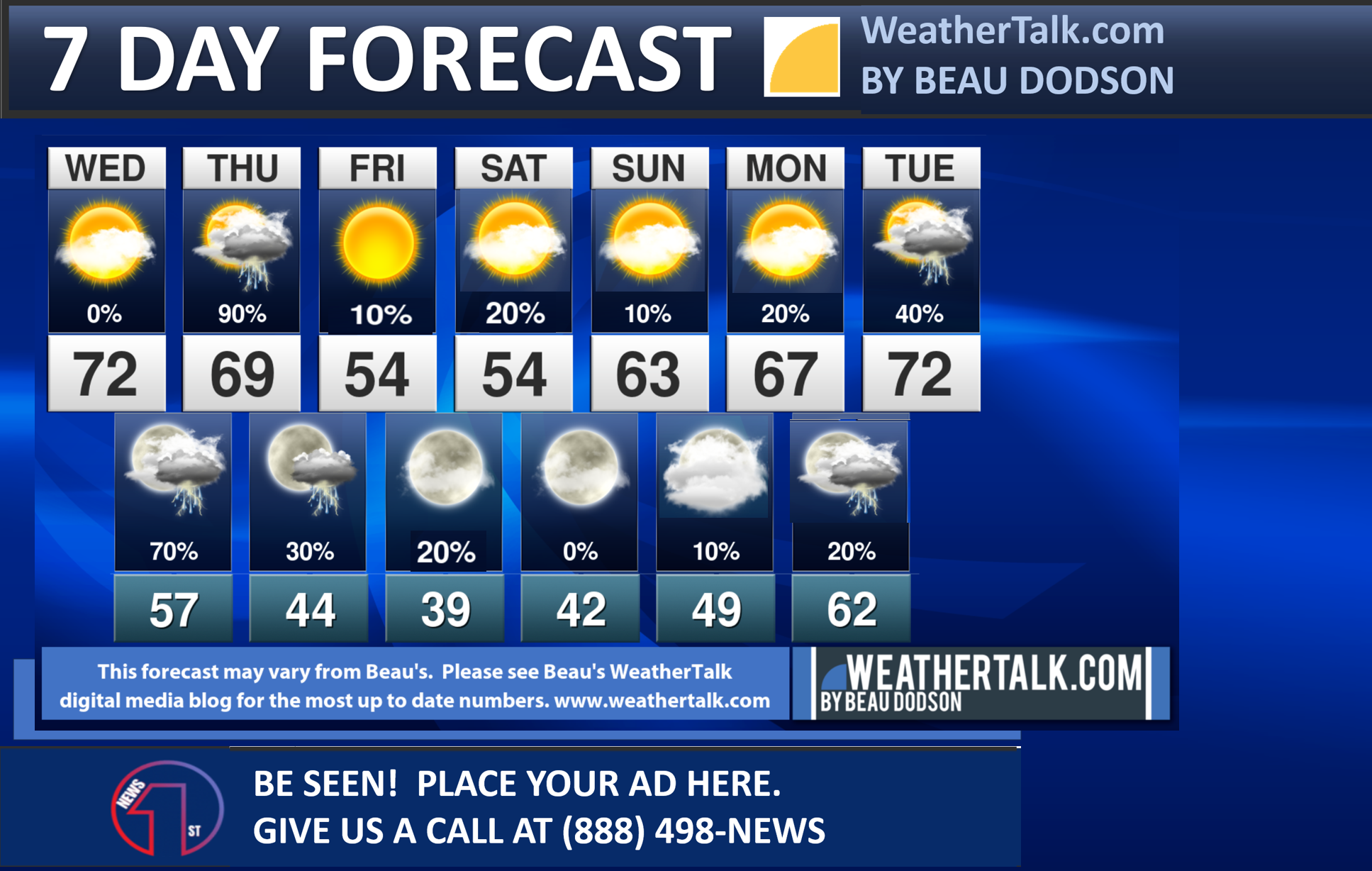
Seven-day forecast for southeast Missouri, southern Illinois, western Kentucky, and western Tennessee.
This is a BLEND for the region. Scroll down to see the region by region forecast.
THE FORECAST IS GOING TO VARY FROM LOCATION TO LOCATION. Scroll down to see the region by region forecast.
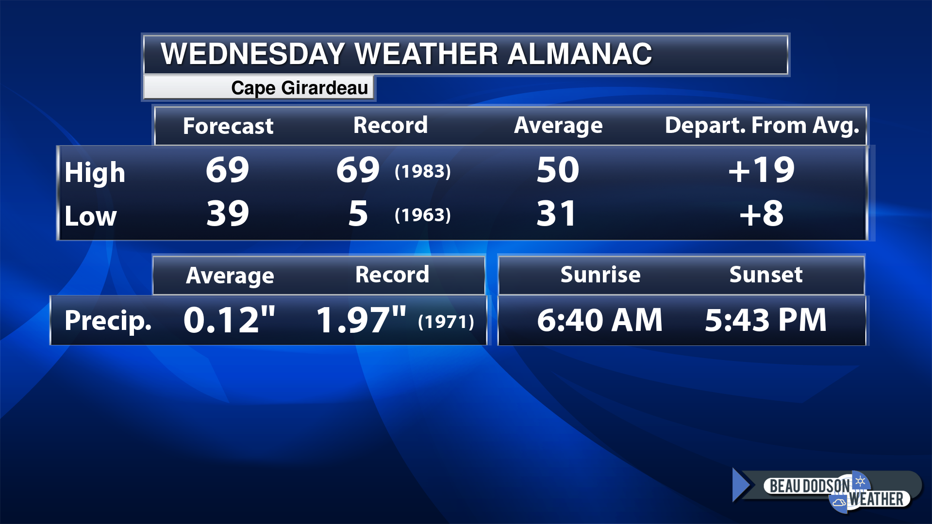
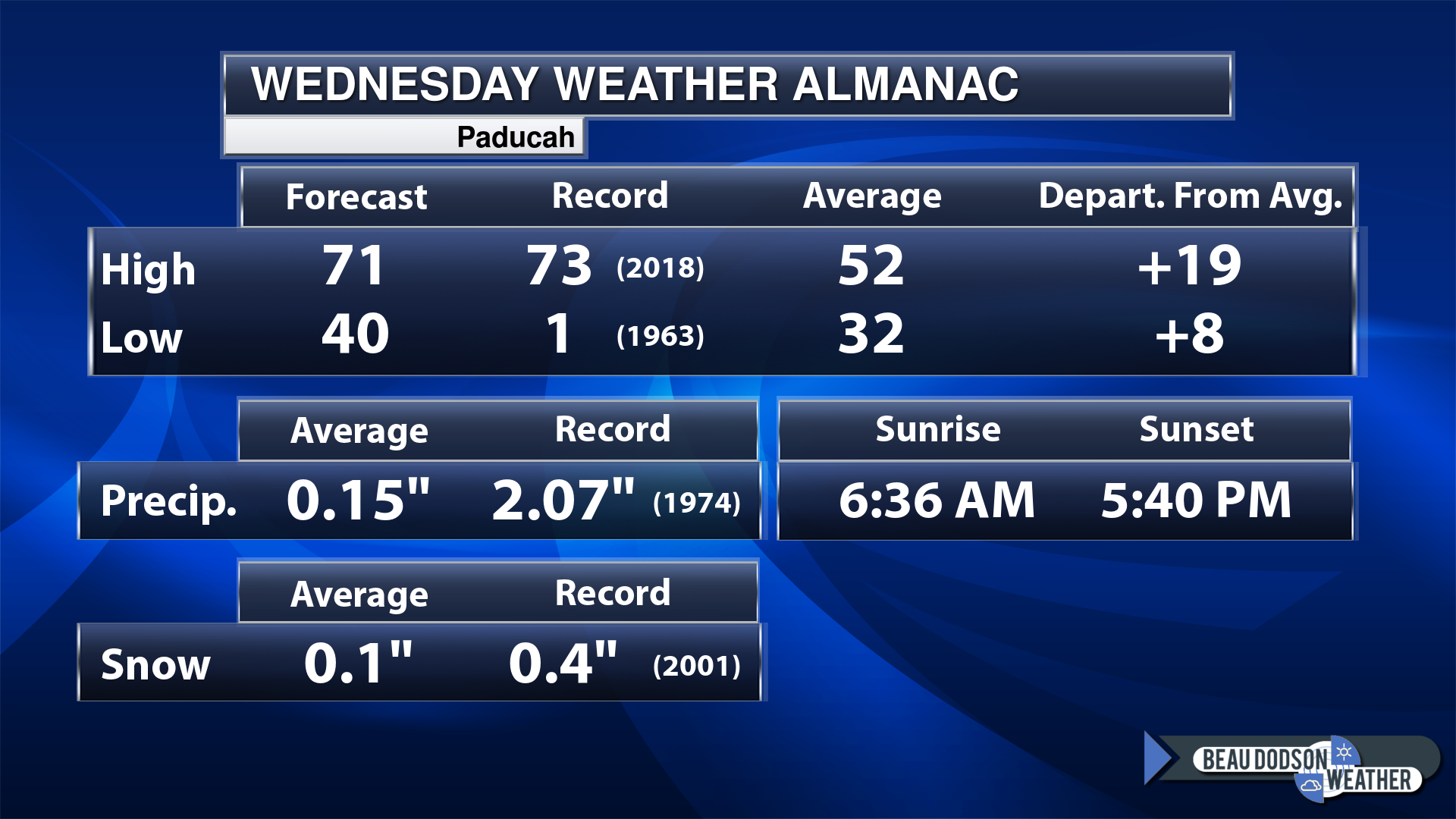
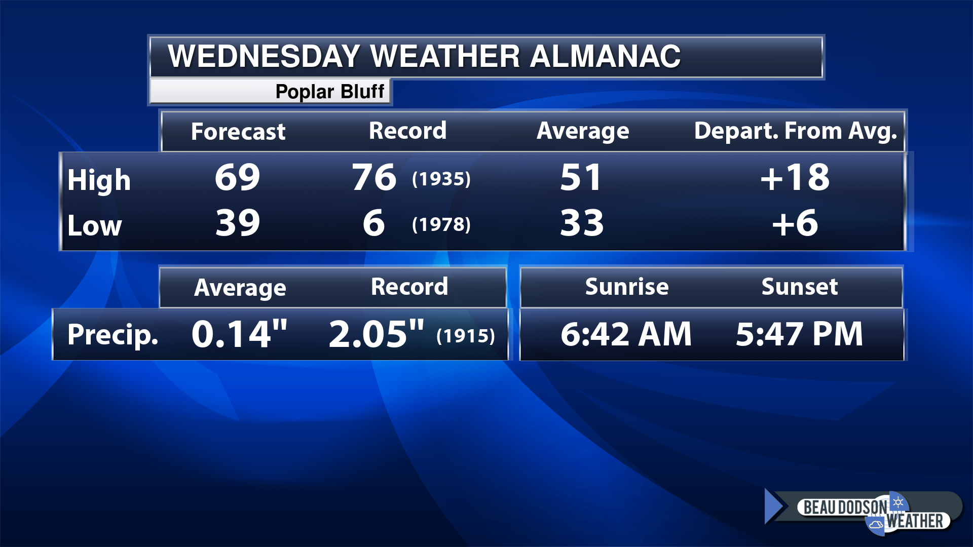
Today’s Local Almanacs (for a few select cities). Your location will be comparable.
Note, the low is this morning’s low and not tomorrows.
Today’s almanac numbers from a few select local cities.
The forecast temperature shows you today’s expected high and this morning’s low.
The graphic shows you the record high and record low for today. It shows you what year that occurred, as well.
It then shows you what today’s average temperature is.
Then, it shows you the departures (how may degrees above or below average temperatures will be ).
It shows you the average precipitation for today. Average comes from thirty years of rain totals.
It also shows you the record rainfall for the date and what year that occurred.
The sunrise and sunset are also shown.

If you have not subscribed to my YouTube Channel then click on this link and it will take you to my videos.
Click the button below and it will take you to the Beau Dodson YouTube Channel.

![]()
48-hour forecast


.

.
Wednesday to Wednesday
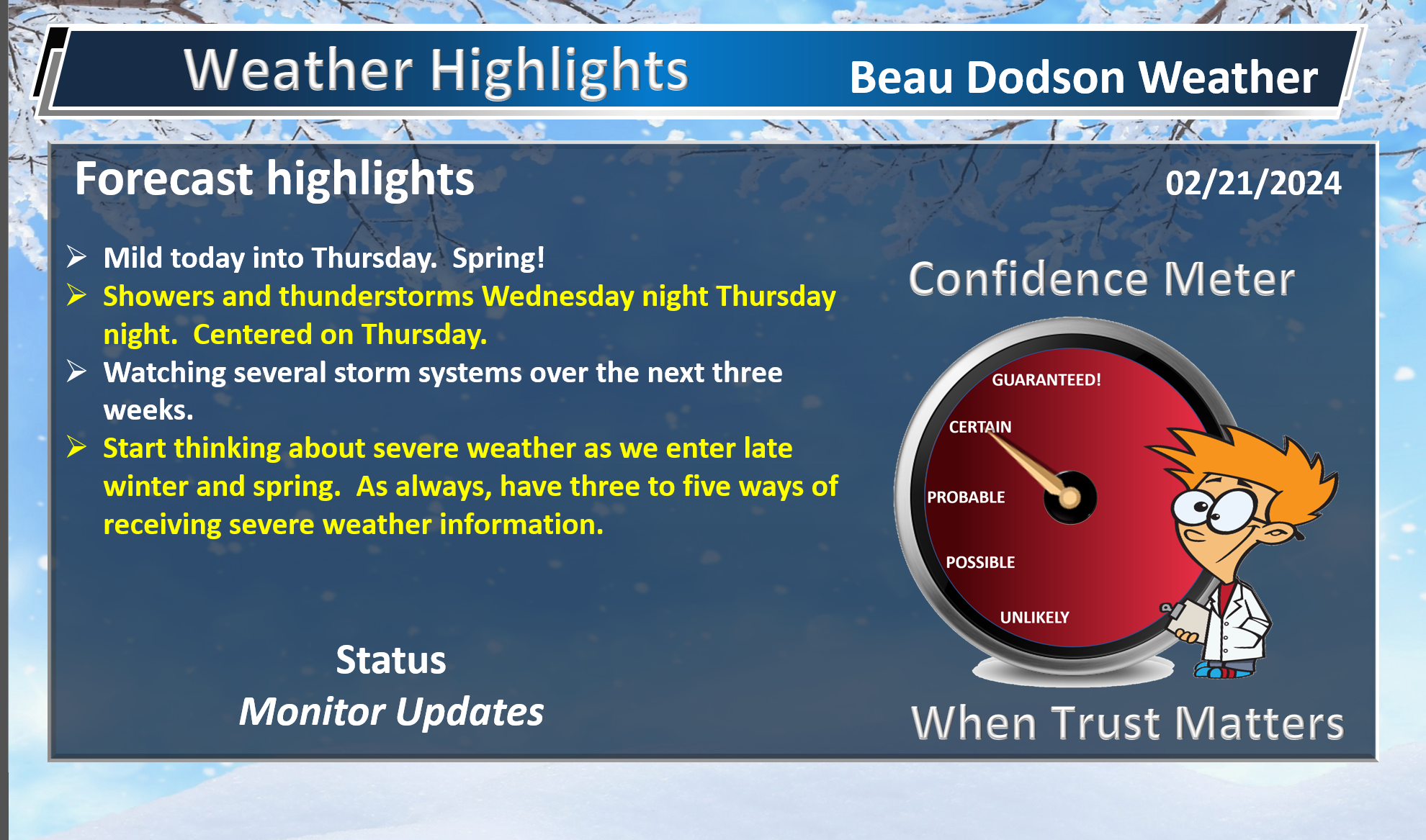
1. Is lightning in the forecast? YES. Lightning is likely Thursday/Thursday night. Another chance next Wednesday and Thursday.
2. Are severe thunderstorms in the forecast? YES. I am closely watching Thursday. A few of Thursday’s storms could produce gusty wind and small hail. The threat of actual severe storms is low. I am watching next Tuesday. A larger severe weather event appears possible. Monitor updates.
3. Is flash flooding in the forecast? NO.
4. Will the heat index exceed 100 degrees? NO.
5. Will the wind chill dip below 10 degrees? NO.
6. Is measurable snow and/or sleet in the forecast? NO.
7. Is freezing rain/ice in the forecast? NO.
Freezing rain is rain that falls and instantly freezes on objects such as trees and power lines Freezing fog possible, as well.
.
Fire weather risk level.
Wednesday: 5. Moderate risk.
Wednesday night. 4. Low risk.
Thursday through Thursday night: 3. Very low risk.
Fire Weather Discussion
Strong southerly winds will usher in a more humid airmass today. Temperatures will be much warmer but with higher dewpoints expected, RH values should be quite a bit higher today compared to recent days. Sustained south winds near 15 mph and gusts of 20 to 25 mph are expected, which will help provide good smoke dispersion. A frontal passage occurs on Thursday accompanied by a good chance for a wetting rain along with a few thunderstorms. Winds switch around to northwesterly Thursday night through Saturday, ushering in a much cooler airmass. Southerly winds return on Sunday along with a significant warming trend that is expected to last into mid next week, when a strong storm system may impact the region.
A Haines Index of 6 means a high potential for an existing fire to become large or exhibit erratic fire behavior, 5 means medium potential, 4 means low potential, and anything less than 4 means very low potential.
.

.
Wednesday Forecast: Mostly sunny the first half of the day. Increasing clouds during the afternoon and evening. Very mild for February.
What is the chance of precipitation?
Far northern southeast Missouri ~ 0%
Southeast Missouri ~ 0%
The Missouri Bootheel ~ 0%
I-64 Corridor of southern Illinois ~ 0%
Southern Illinois ~ 0%
Extreme southern Illinois (southern seven counties) ~ 0%
Far western Kentucky (Purchase area) ~ 0%
The Pennyrile area of western KY ~ 0%
Northwest Kentucky (near Indiana border) ~ 0%
Northwest Tennessee ~ 0%
Coverage of precipitation:
Timing of the precipitation:
Far northern southeast Missouri ~ 66° to 68°
Southeast Missouri ~ 66° to 70°
The Missouri Bootheel ~ 66° to 70°
I-64 Corridor of southern Illinois ~ 63° to 66°
Southern Illinois ~ 64° to 68°
Extreme southern Illinois (southern seven counties) ~ 66° to 70°
Far western Kentucky ~ 66° to 70°
The Pennyrile area of western KY ~ 66° to 70°
Northwest Kentucky (near Indiana border) ~ 66° to 70°
Northwest Tennessee ~ 68° to 70°
Winds will be from this direction: Southwest 10 to 25 mph. Gusty.
Wind chill or heat index (feels like) temperature forecast: 62° to 68°
What impacts are anticipated from the weather?
Should I cancel my outdoor plans? No
UV Index: 4. Moderate.
Sunrise: 6:37 AM
Sunset: 5:41 PM .
.
Wednesday Night Forecast: Mostly cloudy. A chance of late night showers and thunderstorms. Breezy.
What is the chance of precipitation?
Far northern southeast Missouri ~ 40%
Southeast Missouri ~ 40%
The Missouri Bootheel ~ 30%
I-64 Corridor of southern Illinois ~ 30%
Southern Illinois ~ 30%
Extreme southern Illinois (southern seven counties) ~ 30%
Far western Kentucky (Purchase area) ~ 30%
The Pennyrile area of western KY ~ 30%
Northwest Kentucky (near Indiana border) ~ 30%
Northwest Tennessee ~ 30%
Coverage of precipitation: Scattered
Timing of the precipitation: After midnight.
Temperature range:
Far northern southeast Missouri ~ 52° to 55°
Southeast Missouri ~ 52° to 55°
The Missouri Bootheel ~ 52° to 55°
I-64 Corridor of southern Illinois ~ 52° to 55°
Southern Illinois ~ 52° to 55°
Extreme southern Illinois (southern seven counties) ~ 52° to 55°
Far western Kentucky ~ 52° to 55°
The Pennyrile area of western KY ~ 52° to 55°
Northwest Kentucky (near Indiana border) ~ 52° to 55°
Northwest Tennessee ~ 52° to 55°
Winds will be from this direction: South southwest 10 to 30 mph.
Wind chill or heat index (feels like) temperature forecast: 48° to 54°
What impacts are anticipated from the weather? Wet roadways.
Should I cancel my outdoor plans? No, but monitor the Beau Dodson Weather Radars
Moonrise: 3:00 PM
Moonset: 5:24 AM
The phase of the moon: Waxing Gibbous
.
Thursday Forecast: Mostly cloudy with showers and thunderstorms. Breezy.
What is the chance of precipitation?
Far northern southeast Missouri ~ 80%
Southeast Missouri ~ 80%
The Missouri Bootheel ~ 100%
I-64 Corridor of southern Illinois ~ 80%
Southern Illinois ~ 80%
Extreme southern Illinois (southern seven counties) ~ 100%
Far western Kentucky (Purchase area) ~ 100%
The Pennyrile area of western KY ~ 90%
Northwest Kentucky (near Indiana border) ~ 80%
Northwest Tennessee ~ 100%
Coverage of precipitation: Widespread
Timing of the precipitation: Any given point of time.
Far northern southeast Missouri ~ 62° to 65°
Southeast Missouri ~ 62° to 65°
The Missouri Bootheel ~ 64° to 68°
I-64 Corridor of southern Illinois ~ 62° to 65°
Southern Illinois ~ 64° to 66°
Extreme southern Illinois (southern seven counties) ~ 64° to 66°
Far western Kentucky ~ 64° to 66°
The Pennyrile area of western KY ~ 64° to 68°
Northwest Kentucky (near Indiana border) ~ 64° to 68°
Northwest Tennessee ~ 64° to 68°
Winds will be from this direction: South southwest 10 to 30 mph. Gusty. Wind becoming west northwest behind the cold front.
Wind chill or heat index (feels like) temperature forecast: 62° to 68°
What impacts are anticipated from the weather? Wet roadways. Lightning.
Should I cancel my outdoor plans? Have a plan B. Rain is likely.
UV Index: 2. Low.
Sunrise: 6:36 AM
Sunset: 5:42 PM .
.
Thursday Night Forecast: Mostly cloudy. A chance of evening showers and thunderstorms. Breezy.
What is the chance of precipitation?
Far northern southeast Missouri ~ 20%
Southeast Missouri ~ 20%
The Missouri Bootheel ~ 20%
I-64 Corridor of southern Illinois ~ 20%
Southern Illinois ~ 20%
Extreme southern Illinois (southern seven counties) ~ 40%
Far western Kentucky (Purchase area) ~ 40%
The Pennyrile area of western KY ~ 60%
Northwest Kentucky (near Indiana border) ~ 30%
Northwest Tennessee ~ 40%
Coverage of precipitation: Scattered
Timing of the precipitation: Before midnight.
Temperature range:
Far northern southeast Missouri ~ 36° to 40°
Southeast Missouri ~ 36° to 40°
The Missouri Bootheel ~ 38° to 42°
I-64 Corridor of southern Illinois ~ 38° to 42°
Southern Illinois ~ 40° to 44°
Extreme southern Illinois (southern seven counties) ~ 40° to 44°
Far western Kentucky ~ 40° to 44°
The Pennyrile area of western KY ~ 40° to 44°
Northwest Kentucky (near Indiana border) ~ 40° to 44°
Northwest Tennessee ~ 40° to 44°
Winds will be from this direction: Northwest 15 to 25 mph with higher gusts.
Wind chill or heat index (feels like) temperature forecast: 34° to 42°
What impacts are anticipated from the weather? Wet roadways. Lightning.
Should I cancel my outdoor plans? Have a plan B early in the evening. The rain may have ended over a good chunk of the region. Ending west to east.
Moonrise: 4:02 PM
Moonset: 5:59 AM
The phase of the moon: Waxing Gibbous
.
Friday Forecast: Becoming mostly sunny.
What is the chance of precipitation?
Far northern southeast Missouri ~ 0%
Southeast Missouri ~ 0%
The Missouri Bootheel ~ 0%
I-64 Corridor of southern Illinois ~ 0%
Southern Illinois ~ 0%
Extreme southern Illinois (southern seven counties) ~ 0%
Far western Kentucky (Purchase area) ~ 0%
The Pennyrile area of western KY ~ 0%
Northwest Kentucky (near Indiana border) ~ 0%
Northwest Tennessee ~ 0%
Coverage of precipitation:
Timing of the precipitation:
Far northern southeast Missouri ~ 52° to 55°
Southeast Missouri ~ 52° to 55°
The Missouri Bootheel ~ 54° to 58°
I-64 Corridor of southern Illinois ~ 52° to 54°
Southern Illinois ~ 52° to 55°
Extreme southern Illinois (southern seven counties) ~ 52° to 55°
Far western Kentucky ~ 54° to 58°
The Pennyrile area of western KY ~ 54° to 58°
Northwest Kentucky (near Indiana border) ~ 54° to 58°
Northwest Tennessee ~ 54° to 58°
Winds will be from this direction: Northwest 10 to 20 mph. Gusty.
Wind chill or heat index (feels like) temperature forecast: 50° to 55°
What impacts are anticipated from the weather?
Should I cancel my outdoor plans? No
UV Index: 2. Low.
Sunrise: 6:35 AM
Sunset: 5:43 PM .
.
Friday Night Forecast: A few clouds. A slight chance of light showers over mainly southern Illinois and northwest Kentucky.
What is the chance of precipitation?
Far northern southeast Missouri ~ 10%
Southeast Missouri ~ 0%
The Missouri Bootheel ~ 0%
I-64 Corridor of southern Illinois ~ 20%
Southern Illinois ~ 20%
Extreme southern Illinois (southern seven counties) ~ 10%
Far western Kentucky (Purchase area) ~ 0%
The Pennyrile area of western KY ~ 10%
Northwest Kentucky (near Indiana border) ~ 20%
Northwest Tennessee ~ 0%
Coverage of precipitation: Widely scattered
Timing of the precipitation: After 8 PM
Temperature range:
Far northern southeast Missouri ~ 33° to 36°
Southeast Missouri ~ 33° to 36°
The Missouri Bootheel ~ 34° to 38°
I-64 Corridor of southern Illinois ~ 32° to 34°
Southern Illinois ~ 33° to 36°
Extreme southern Illinois (southern seven counties) ~ 34° to 38°
Far western Kentucky ~ 34° to 38°
The Pennyrile area of western KY ~ 34° to 38°
Northwest Kentucky (near Indiana border) ~ 33° to 36°
Northwest Tennessee ~ 34° to 38°
Winds will be from this direction: Northwest 7 to 14 mph.
Wind chill or heat index (feels like) temperature forecast: 30° to 35°
What impacts are anticipated from the weather?
Should I cancel my outdoor plans? No
Moonrise: 5:03 PM
Moonset: 6:27 AM
The phase of the moon: Full
.
Saturday Forecast: Partly cloudy. A slight chance of sprinkles. A bit lower confidence on whether there might be a few showers in the region.
What is the chance of precipitation?
Far northern southeast Missouri ~ 20%
Southeast Missouri ~ 20%
The Missouri Bootheel ~ 10%
I-64 Corridor of southern Illinois ~ 20%
Southern Illinois ~ 20%
Extreme southern Illinois (southern seven counties) ~ 20%
Far western Kentucky (Purchase area) ~ 20%
The Pennyrile area of western KY ~ 20%
Northwest Kentucky (near Indiana border) ~ 20%
Northwest Tennessee ~ 10%
Coverage of precipitation: Isolated
Timing of the precipitation: Any given point of time.
Far northern southeast Missouri ~ 52° to 55°
Southeast Missouri ~ 52° to 55°
The Missouri Bootheel ~ 56° to 60°
I-64 Corridor of southern Illinois ~ 52° to 54°
Southern Illinois ~ 52° to 55°
Extreme southern Illinois (southern seven counties) ~ 52° to 55°
Far western Kentucky ~ 54° to 58°
The Pennyrile area of western KY ~ 56° to 60°
Northwest Kentucky (near Indiana border) ~ 54° to 58°
Northwest Tennessee ~ 56° to 60°
Winds will be from this direction: Northwest 7 to 14 mph.
Wind chill or heat index (feels like) temperature forecast: 50° to 58°
What impacts are anticipated from the weather?
Should I cancel my outdoor plans? No
UV Index: 4. Moderate.
Sunrise: 6:33 AM
Sunset: 5:44 PM .
.
Saturday Night Forecast: A few passing clouds. Cool.
What is the chance of precipitation?
Far northern southeast Missouri ~ 0%
Southeast Missouri ~ 0%
The Missouri Bootheel ~ 0%
I-64 Corridor of southern Illinois ~ 0%
Southern Illinois ~ 0%
Extreme southern Illinois (southern seven counties) ~ 0%
Far western Kentucky (Purchase area) ~ 0%
The Pennyrile area of western KY ~ 0%
Northwest Kentucky (near Indiana border) ~ 0%
Northwest Tennessee ~ 0%
Coverage of precipitation:
Timing of the precipitation:
Temperature range:
Far northern southeast Missouri ~ 35° to 40°
Southeast Missouri ~ 35° to 40°
The Missouri Bootheel ~ 38° to 40°
I-64 Corridor of southern Illinois ~ 33° to 36°
Southern Illinois ~ 34° to 38°
Extreme southern Illinois (southern seven counties) ~ 35° to 40°
Far western Kentucky ~ 35° to 40°
The Pennyrile area of western KY ~ 35° to 40°
Northwest Kentucky (near Indiana border) ~ 35° to 40°
Northwest Tennessee ~ 35° to 40°
Winds will be from this direction: Becoming west southwest at 7 to 14 mph.
Wind chill or heat index (feels like) temperature forecast: 32° to 38°
What impacts are anticipated from the weather?
Should I cancel my outdoor plans? No
Moonrise: 6:02 PM
Moonset: 6:53 AM
The phase of the moon: Full
.
Sunday Forecast: Partly cloudy.
What is the chance of precipitation?
Far northern southeast Missouri ~ 0%
Southeast Missouri ~ 0%
The Missouri Bootheel ~ 0%
I-64 Corridor of southern Illinois ~ 0%
Southern Illinois ~ 0%
Extreme southern Illinois (southern seven counties) ~ 0%
Far western Kentucky (Purchase area) ~ 0%
The Pennyrile area of western KY ~ 0%
Northwest Kentucky (near Indiana border) ~ 0%
Northwest Tennessee ~ 0%
Coverage of precipitation:
Timing of the precipitation:
Far northern southeast Missouri ~ 65° to 70°
Southeast Missouri ~ 65° to 70°
The Missouri Bootheel ~ 65° to 70°
I-64 Corridor of southern Illinois ~ 65° to 70°
Southern Illinois ~ 65° to 70°
Extreme southern Illinois (southern seven counties) ~ 65° to 70°
Far western Kentucky ~ 65° to 70°
The Pennyrile area of western KY ~ 65° to 70°
Northwest Kentucky (near Indiana border) ~ 65° to 70°
Northwest Tennessee ~ 65° to 70°
Winds will be from this direction: South southwest 10 to 25 mph. Gusty.
Wind chill or heat index (feels like) temperature forecast: 65° to 70°
What impacts are anticipated from the weather?
Should I cancel my outdoor plans? No
UV Index: 4. Moderate.
Sunrise: 6:32 AM
Sunset: 5:45 PM .
.
Sunday Night Forecast: Partly cloudy.
What is the chance of precipitation?
Far northern southeast Missouri ~ 0%
Southeast Missouri ~ 0%
The Missouri Bootheel ~ 0%
I-64 Corridor of southern Illinois ~ 0%
Southern Illinois ~ 0%
Extreme southern Illinois (southern seven counties) ~ 0%
Far western Kentucky (Purchase area) ~ 0%
The Pennyrile area of western KY ~ 0%
Northwest Kentucky (near Indiana border) ~ 0%
Northwest Tennessee ~ 0%
Coverage of precipitation:
Timing of the precipitation:
Temperature range:
Far northern southeast Missouri ~ 44° to 46°
Southeast Missouri ~ 44° to 48°
The Missouri Bootheel ~ 46° to 48°
I-64 Corridor of southern Illinois ~ 44° to 46°
Southern Illinois ~ 44° to 46°
Extreme southern Illinois (southern seven counties) ~ 44° to 48°
Far western Kentucky ~ 44° to 48°
The Pennyrile area of western KY ~ 44° to 48°
Northwest Kentucky (near Indiana border) ~ 44° to 46°
Northwest Tennessee ~ 46° to 48°
Winds will be from this direction: South southwest 10 to 25 mph. Gusty.
Wind chill or heat index (feels like) temperature forecast: 42° to 46°
What impacts are anticipated from the weather?
Should I cancel my outdoor plans? No
Moonrise: 7:00 PM
Moonset: 7:15 AM
The phase of the moon: Waning Gibbous
.
Click here if you would like to return to the top of the page.

-
- Mild mild mild. Spring weather has arrived!
- Mild weather to continue into next week.
- A strong cold front moves through the region Thursday/Thursday night. Bringing showers and thunderstorms.
- Watching several systems next week. Monitor for the risk of thunderstorms.
Weather advice:
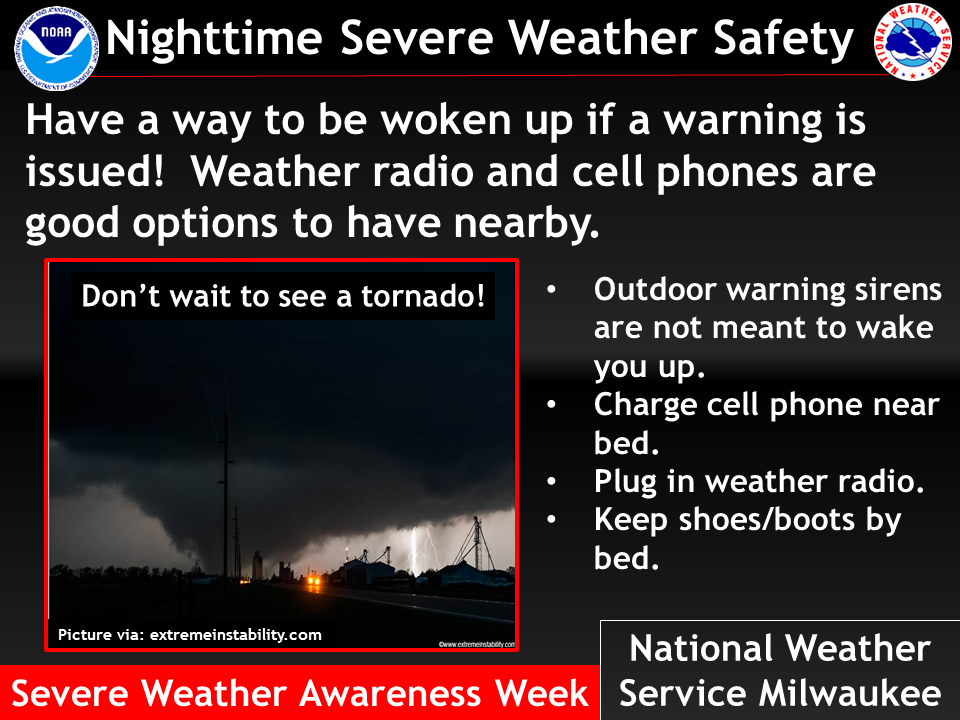
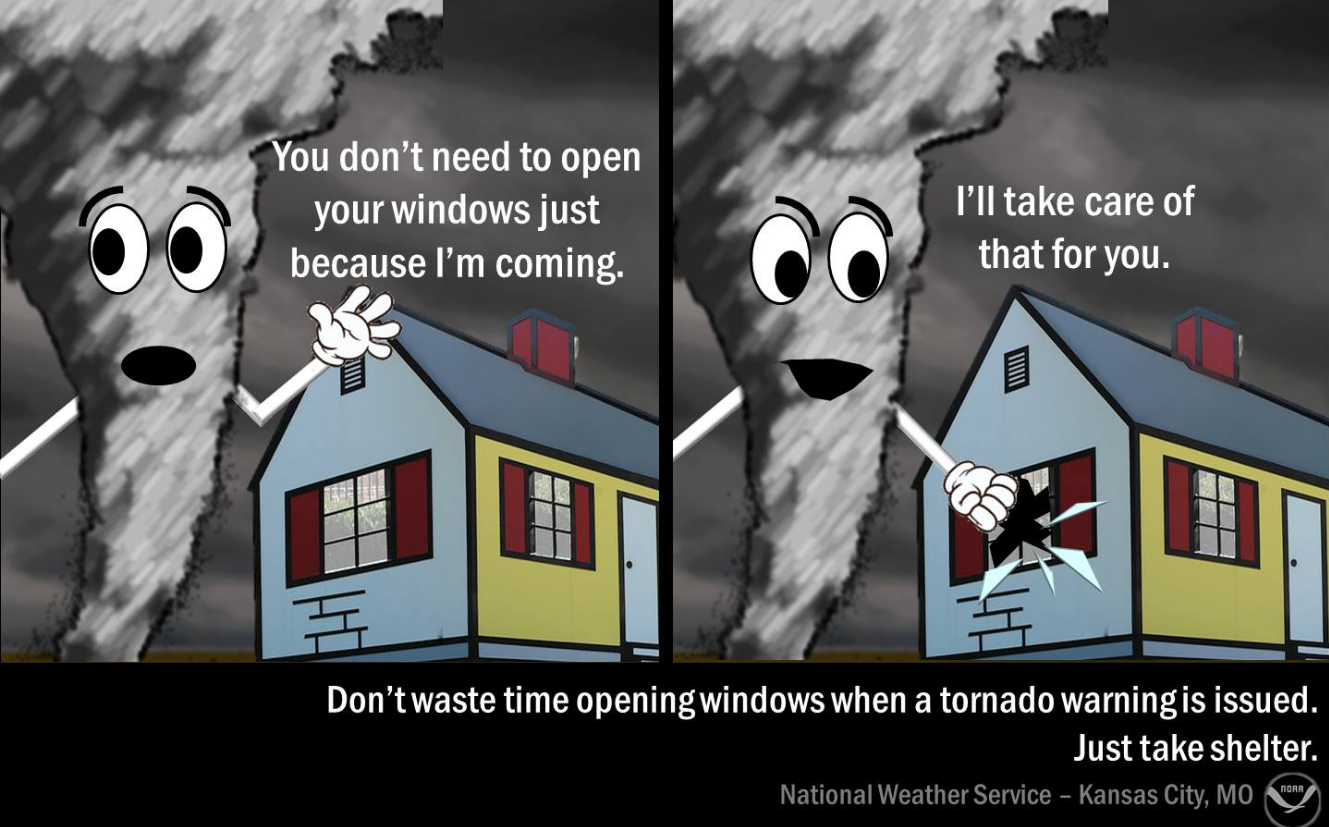
Make sure you have three to five ways of receiving your severe weather information.
Let’s start thinking about severe weather as we move into the coming weeks.
Forecast Discussion
That front will move eastward Thursday night.
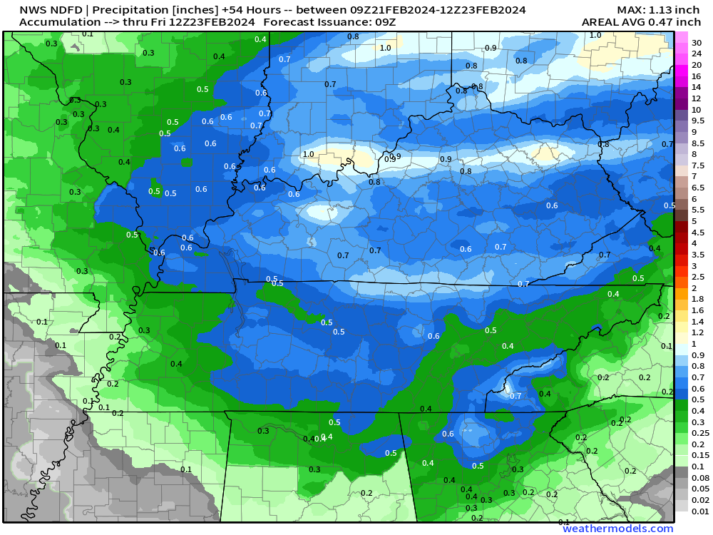
Rainfall totals will range from 0.20″ to 0.55″.
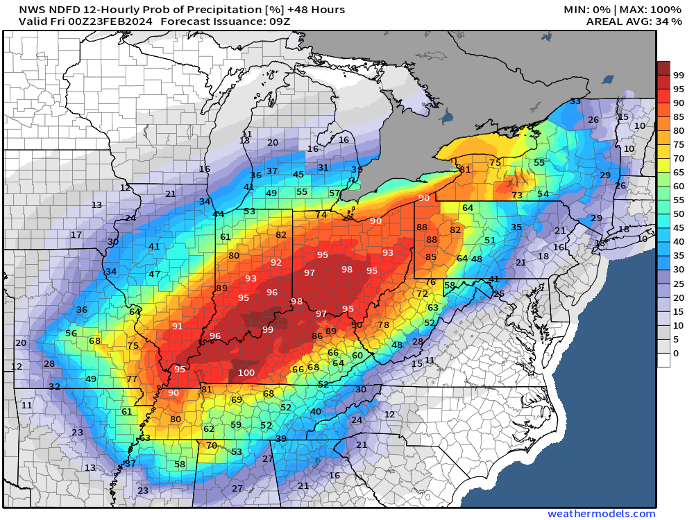
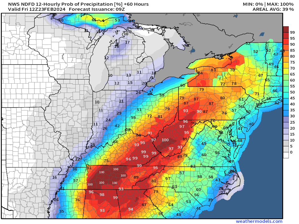
Let’s look at rain probabilities.
Wednesday night
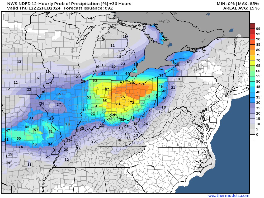
Thursday
Thursday night
Friday into Sunday will be dry. A little cooler, but honestly the bulk of the cold will miss us behind this front.
There is a weak system that will brush the region Sunday. Some data shows sprinkles. I will watch it.
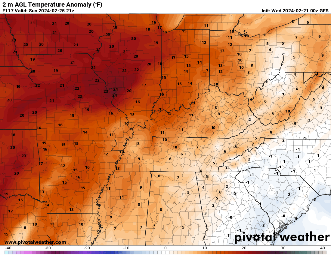
Temperatures Saturday and Sunday will be near normal to above normal.
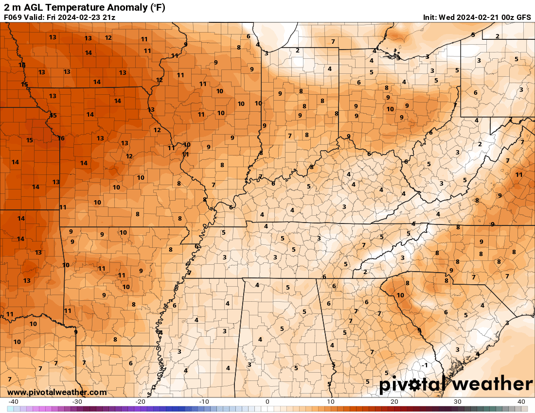
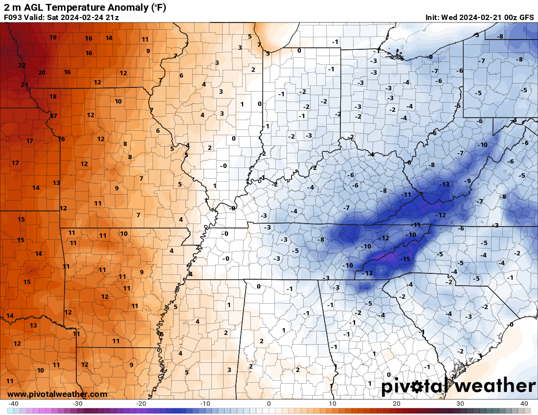
Let’s look at anomalies
How many degrees above average.
Normal highs are around 52 degrees. Normal lows are around 34 degrees.
Friday
Saturday
Sunday
Monday
Tuesday
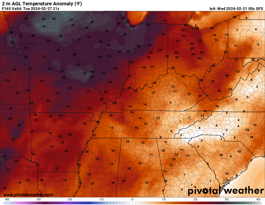
Mild next week with several systems to closely monitor. There could be several days of severe weather next week in the central and eastern USA. We need to watch it closely.
I am watching Tuesday for increasing chances of thunderstorms.
The SPC will start posting severe weather updates on this tomorrow.
We usually don’t forecast severe weather in the long long range. But, I am watching a couple of low pressure centers and cold fronts next week. Monitor updates in case we end up in the severe weather threat zone.
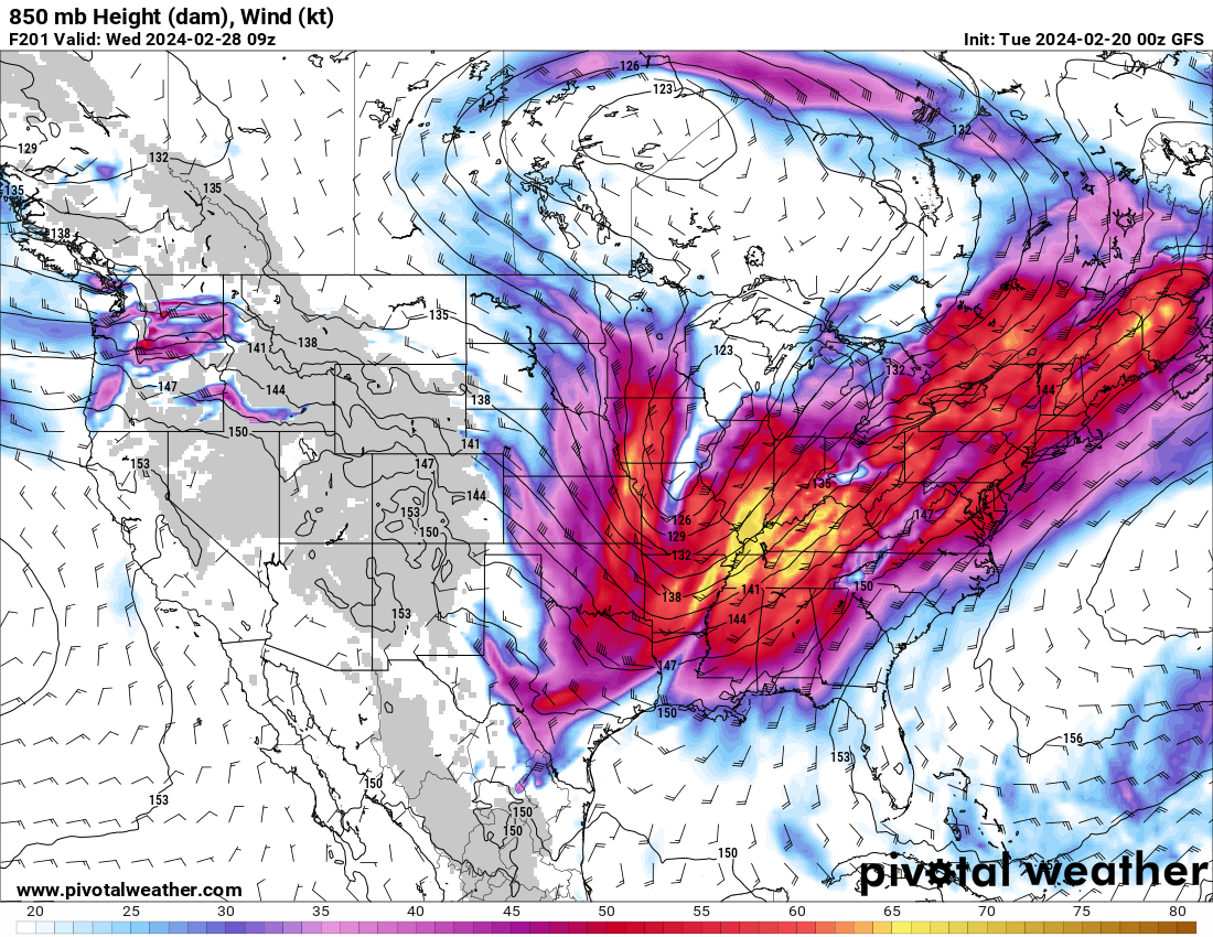
Looking at the 500 mb winds. We can see it looks like a ski jump. That is a signal for severe weather.
This is Tuesday.
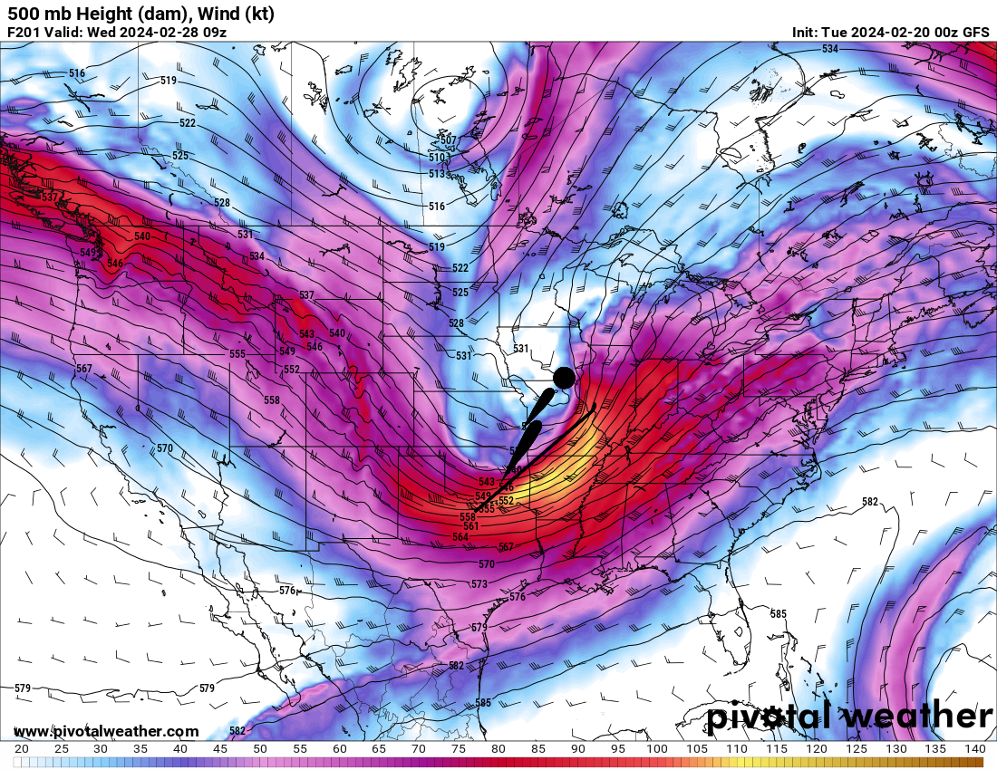
And strong 850 mb low level jet
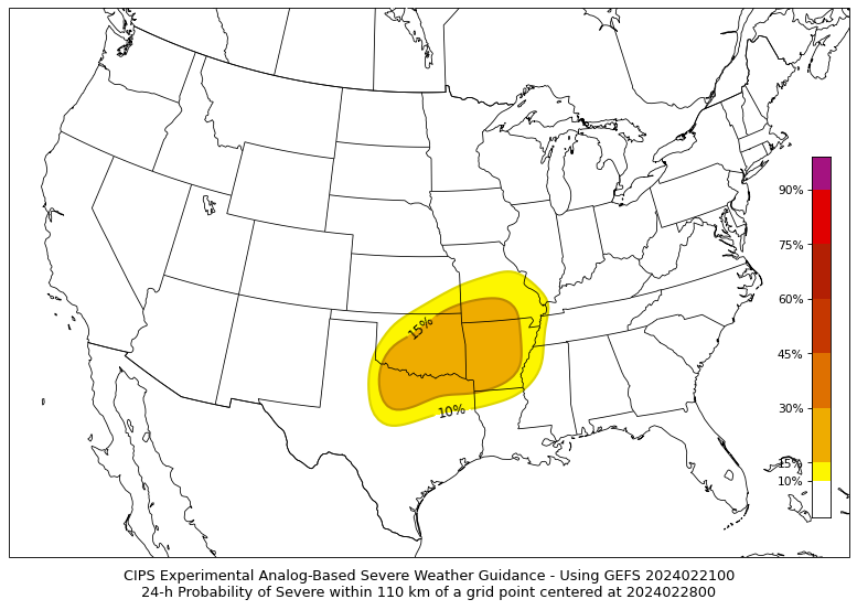
CIPS analogs looks back at past events and compares the setup.
They do show some signals for severe weather next week.
Just a matter of where. It is likely that this area will expand with time.
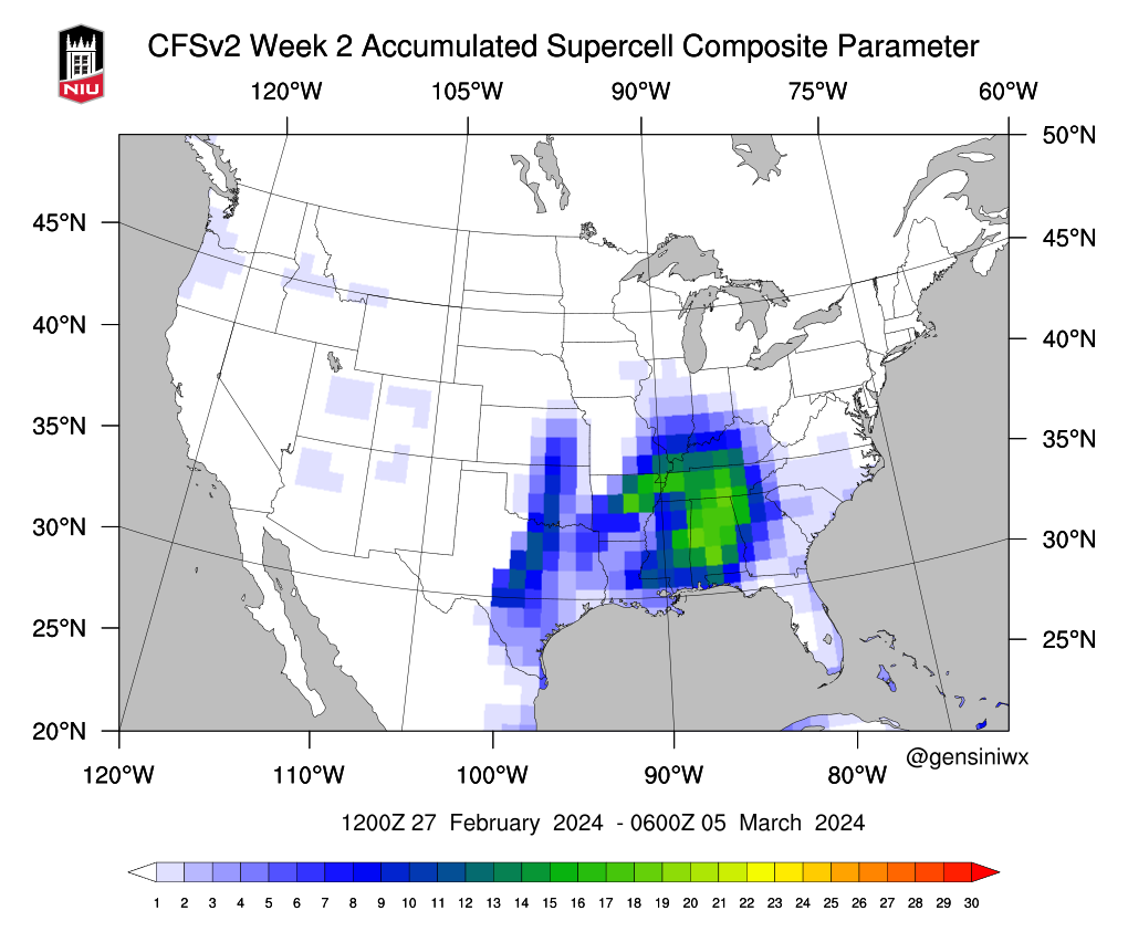
Next weeks accumulated supercell parameters. This simply shows you where severe weather could occur.
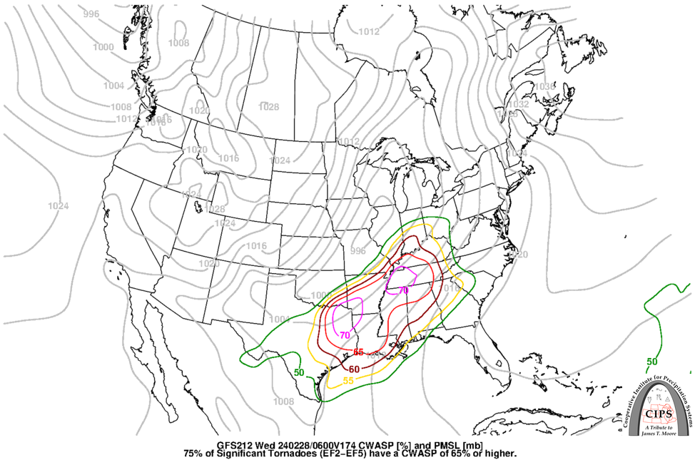
Another severe weather parameter is CWASP
![]()
.
Click here if you would like to return to the top of the page.
This outlook covers southeast Missouri, southern Illinois, western Kentucky, and far northwest Tennessee.

.
Today’s Storm Prediction Center’s Severe Weather Outlook
Light green is where thunderstorms may occur but should be below severe levels.
Dark green is a level one risk. Yellow is a level two risk. Orange is a level three (enhanced) risk. Red is a level four (moderate) risk. Pink is a level five (high) risk.
One is the lowest risk. Five is the highest risk.
A severe storm is one that produces 58 mph wind or higher, quarter size hail, and/or a tornado.
Explanation of tables. Click here.

.
Tornado Probability Outlook

.
Large Hail Probability Outlook

.
High wind Probability Outlook

.
Tomorrow’s severe weather outlook.

.
Day Three Severe Weather Outlook

.

.
The images below are from NOAA’s Weather Prediction Center.
24-hour precipitation outlook..
 .
.
.
48-hour precipitation outlook.
. .
.
![]()
_______________________________________
.

Click here if you would like to return to the top of the page.
Again, as a reminder, these are models. They are never 100% accurate. Take the general idea from them.
What should I take from these?
- The general idea and not specifics. Models usually do well with the generalities.
- The time-stamp is located in the upper left corner.
.
What am I looking at?
You are looking at computer model data. Meteorologists use many different models to forecast the weather.
Occasionally, these maps are in Zulu time. 12z=7 AM. 18z=1 PM. 00z=7 PM. 06z=1 AM
Green represents light rain. Dark green represents moderate rain. Yellow and orange represent heavier rain.
.
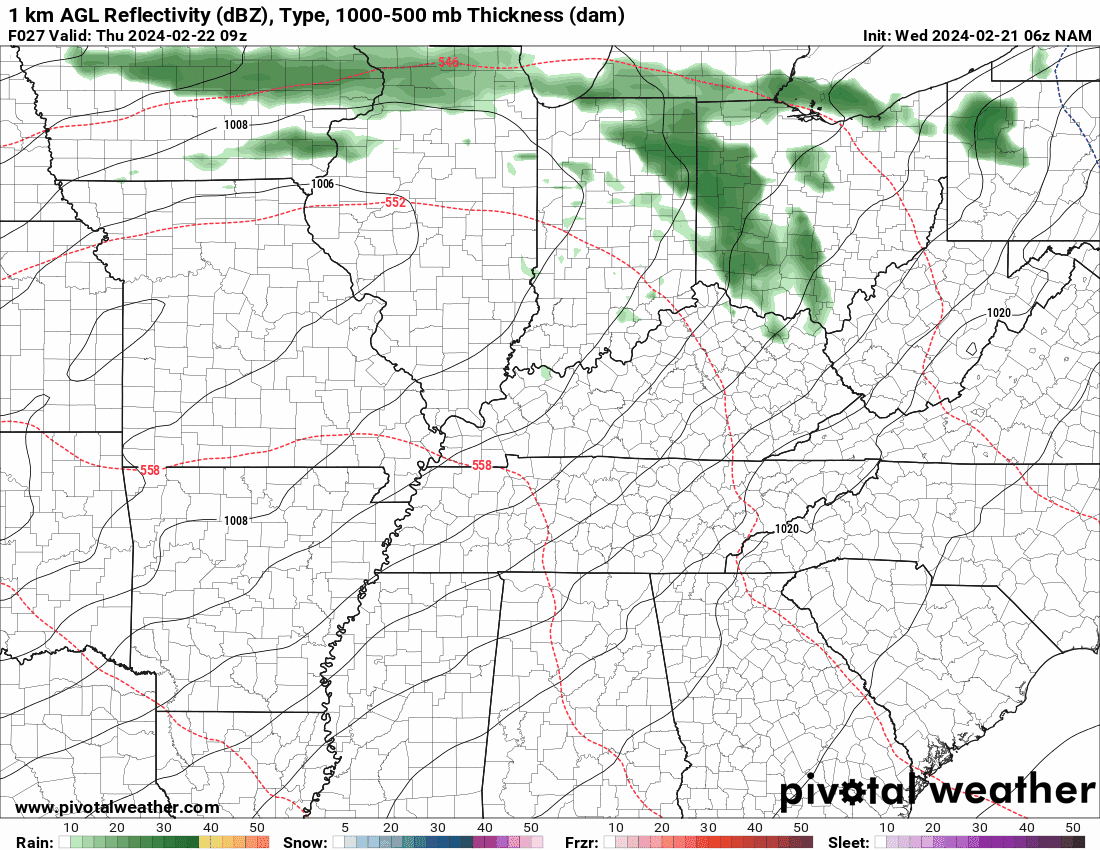
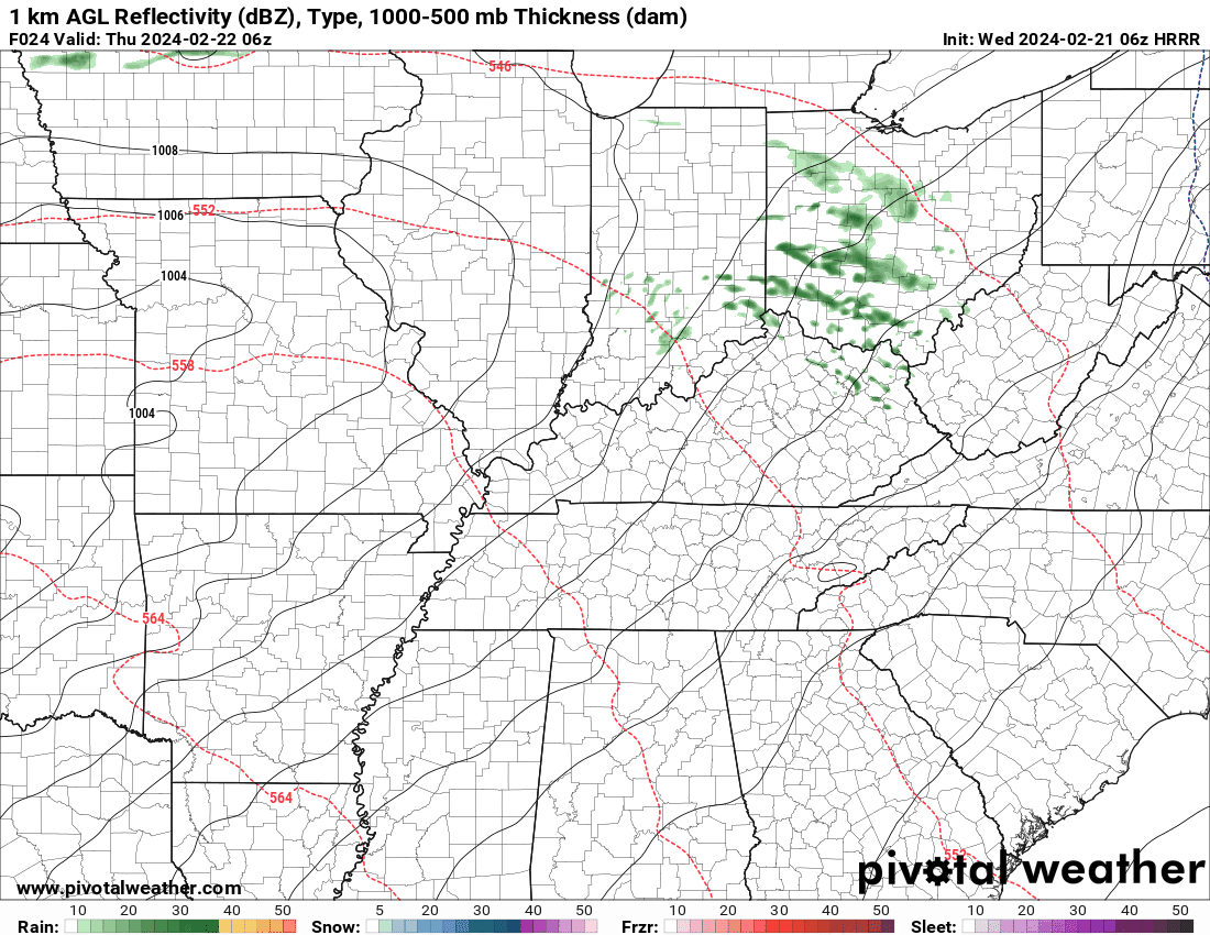
This animation is the HRRR Model.
Occasionally, these maps are in Zulu time. 12z=6 AM. 18z=12 PM. 00z=6 PM. 06z=12 AM
Double click images to enlarge them. Blue is snow. Pink is a wintry mix. Green is rain.
.
This animation is the NAM Model.
Occasionally, these maps are in Zulu time. 12z=6 AM. 18z=12 PM. 00z=6 PM. 06z=12 AM
Double click images to enlarge them.
.
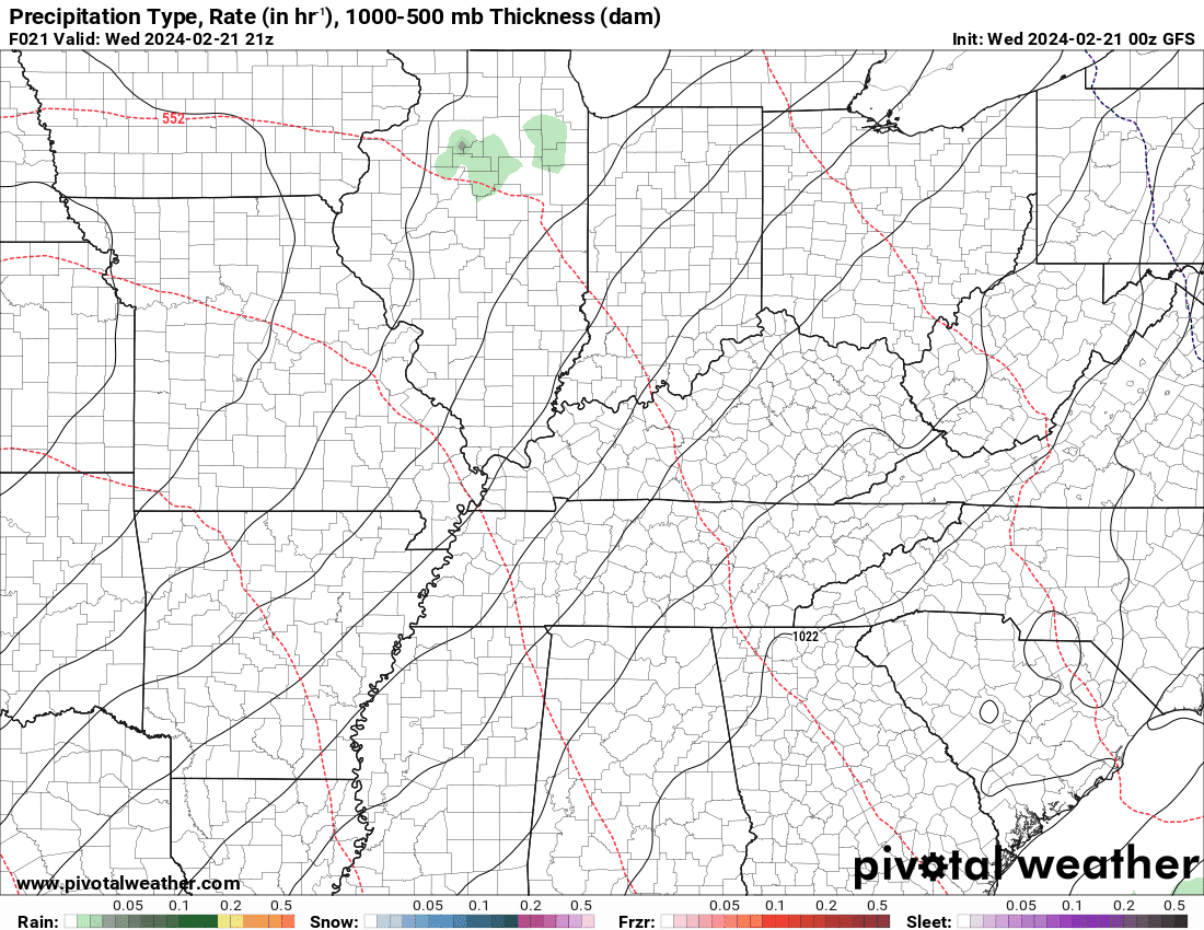
This animation is the GFS Model.
Green is rain. Yellow and orange are heavier rain. Pink is a wintry mix. Blue is snow. Dark blue is heavier snow.
Occasionally, these maps are in Zulu time. 12z=6 AM. 18z=12 PM. 00z=6 PM. 06z=12 AM
Double click images to enlarge them.
.
This animation is the EC Model.
Green is rain. Yellow and orange are heavier rain. Pink is a wintry mix. Blue is snow. Dark blue is heavier snow.
Occasionally, these maps are in Zulu time. 12z=6 AM. 18z=12 PM. 00z=6 PM. 06z=12 AM
Double click images to enlarge them.
..![]()

.
Click here if you would like to return to the top of the page.
.Average high temperatures for this time of the year are around 51 degrees.
Average low temperatures for this time of the year are around 31 degrees.
Average precipitation during this time period ranges from 0.50″ to 1.00″
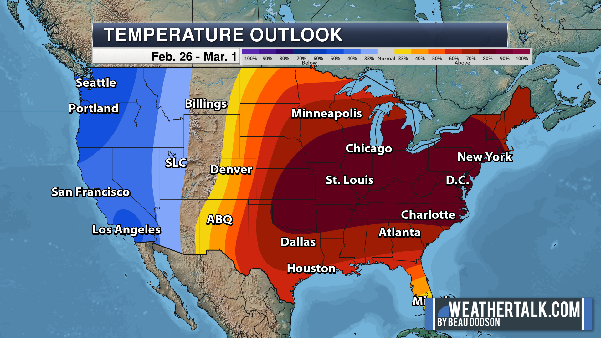
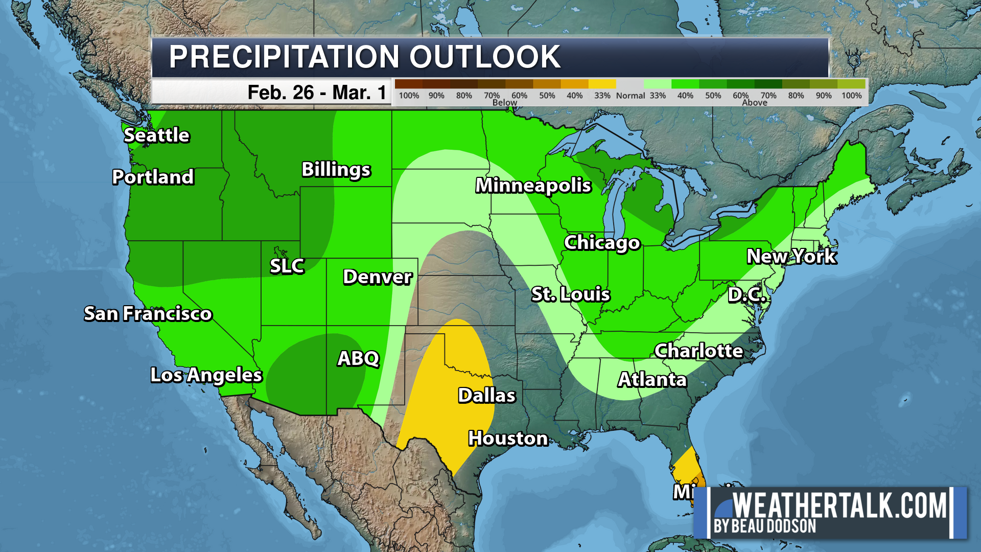
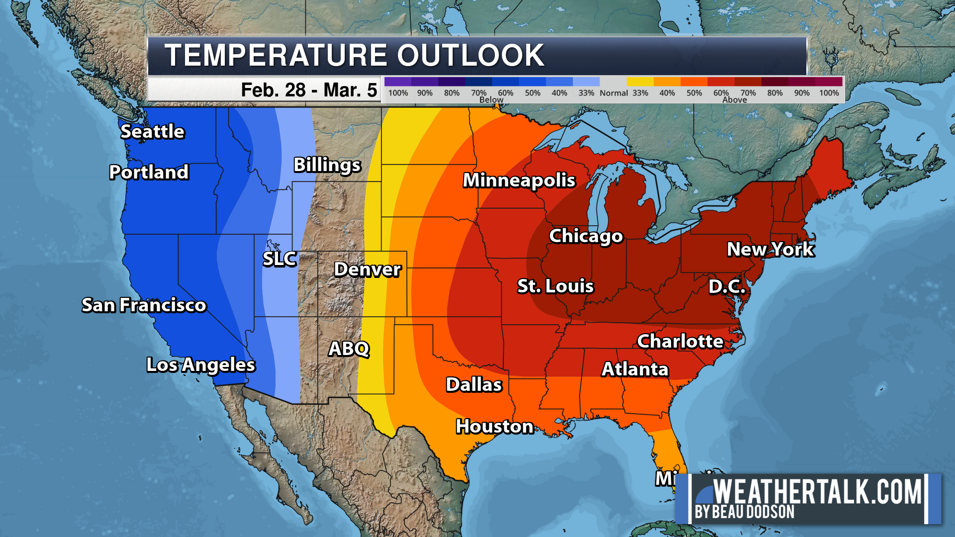
Six to Ten Day Outlook.
Blue is below average. Red is above average. The no color zone represents equal chances.
Average highs for this time of the year are in the lower 60s. Average lows for this time of the year are in the lower 40s.
Green is above average precipitation. Yellow and brown favors below average precipitation. Average precipitation for this time of the year is around one inch per week.
.

Average low temperatures for this time of the year are around 32 degrees.
Average precipitation during this time period ranges from 0.50″ to 1.00″
.
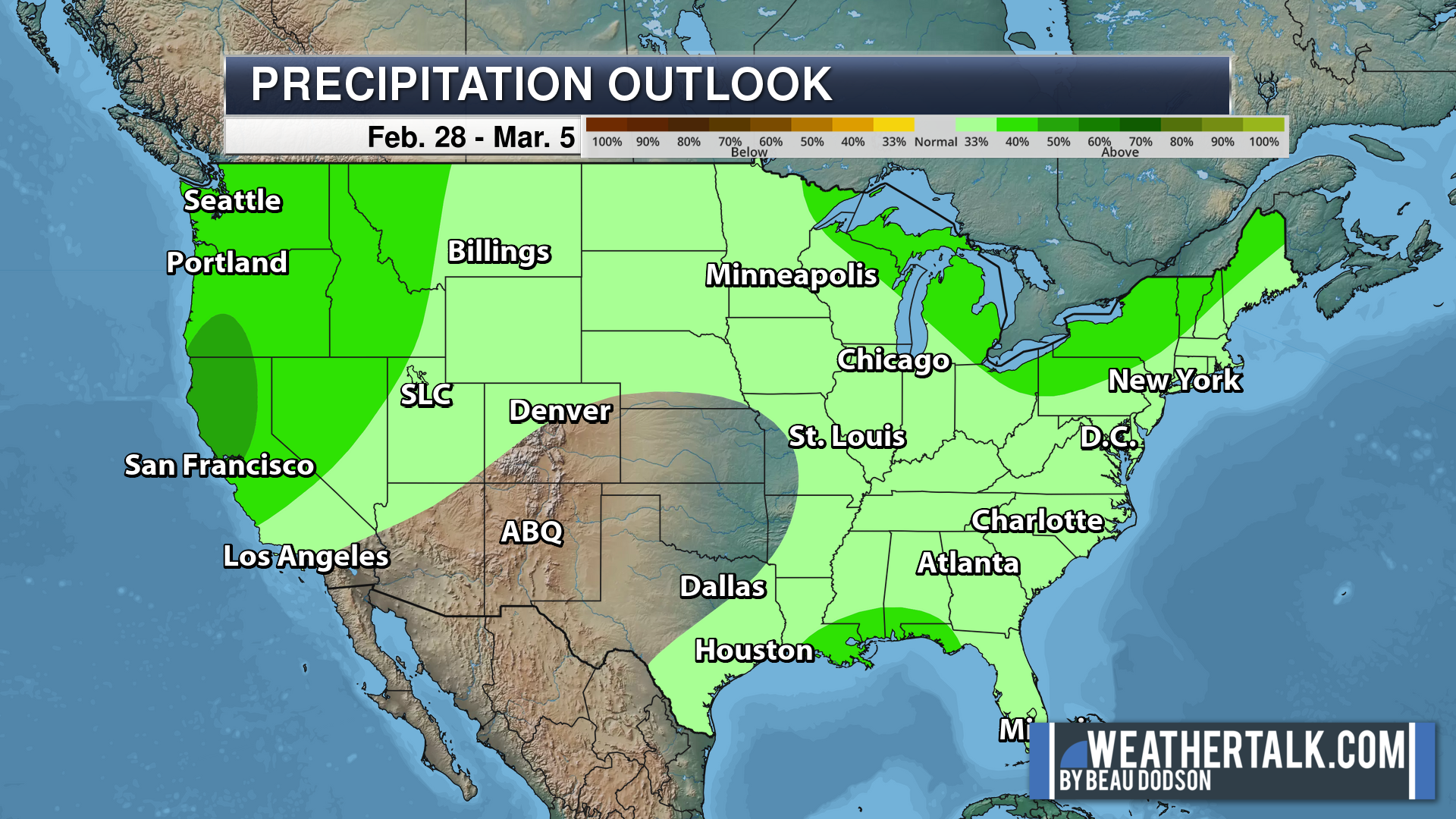
Eight to Fourteen Day Outlook.
Blue is below average. Red is above average. The no color zone represents equal chances.
Green is above average precipitation. Yellow and brown favors below average precipitation. Average precipitation for this time of the year is around one inch per week.
.
![]()
The app is for subscribers. Subscribe at www.weathertalk.com/welcome then go to your app store and search for WeatherTalk
Subscribers, PLEASE USE THE APP. ATT and Verizon are not reliable during severe weather. They are delaying text messages.
The app is under WeatherTalk in the app store.

Apple users click here

Android users click here
.

Radars and Lightning Data
Interactive-city-view radars. Clickable watches and warnings.
https://wtalk.co/B3XHASFZ
If the radar is not updating then try another one. If a radar does not appear to be refreshing then hit Ctrl F5. You may also try restarting your browser.
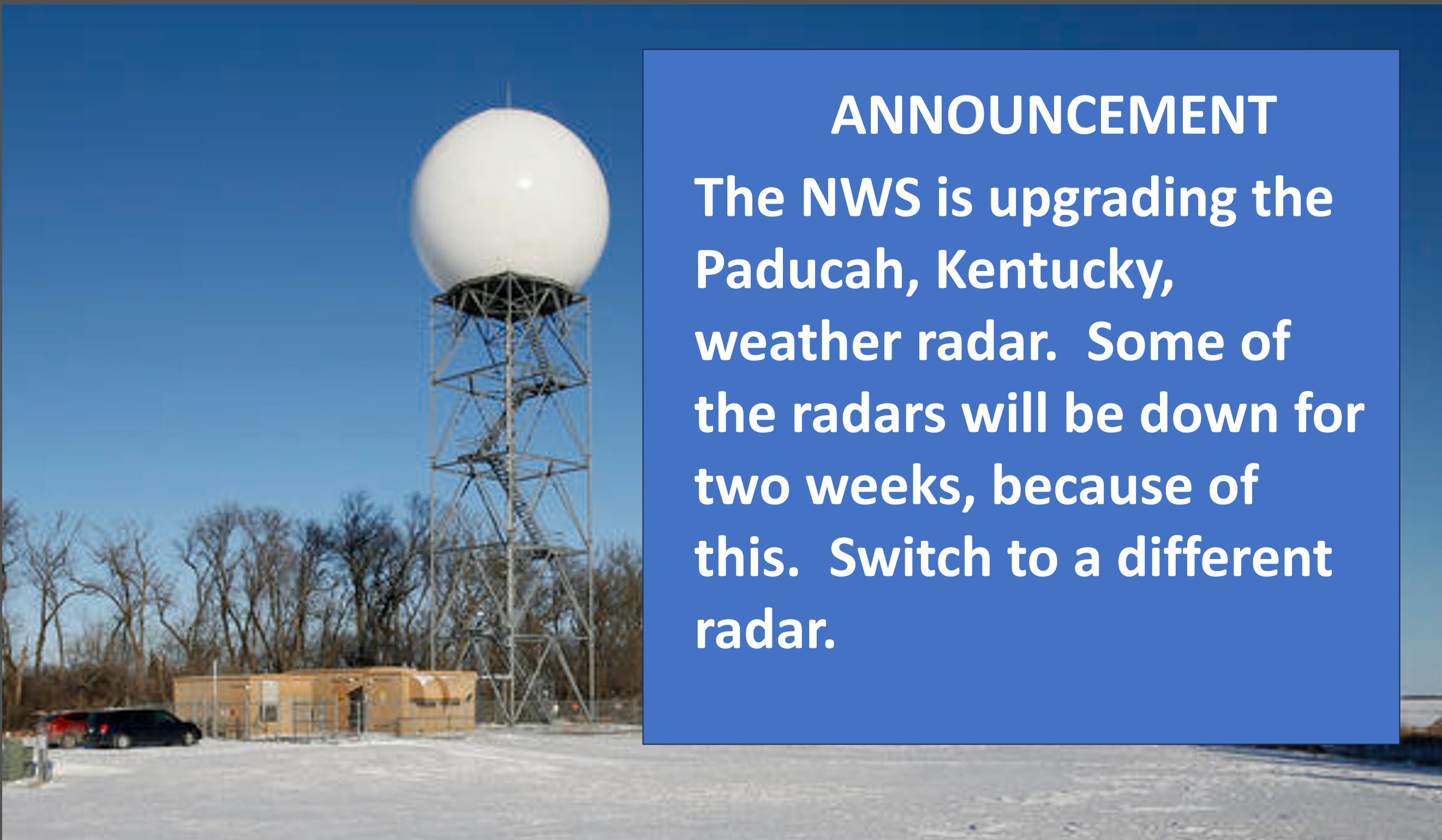
Backup radar site in case the above one is not working.
https://weathertalk.com/morani
Regional Radar
https://imagery.weathertalk.com/prx/RadarLoop.mp4
** NEW ** Zoom radar with chaser tracking abilities!
ZoomRadar
Lightning Data (zoom in and out of your local area)
https://wtalk.co/WJ3SN5UZ
Not working? Email me at beaudodson@usawx.com
National map of weather watches and warnings. Click here.
Storm Prediction Center. Click here.
Weather Prediction Center. Click here.
.

Live lightning data: Click here.
Real time lightning data (another one) https://map.blitzortung.org/#5.02/37.95/-86.99
Our new Zoom radar with storm chases
.
.

Interactive GOES R satellite. Track clouds. Click here.
GOES 16 slider tool. Click here.
College of DuPage satellites. Click here
.

Here are the latest local river stage forecast numbers Click Here.
Here are the latest lake stage forecast numbers for Kentucky Lake and Lake Barkley Click Here.
.
.
Find Beau on Facebook! Click the banner.


 .
.