This is what you are missing out on if you are not a $3 a month subscriber!
- Daily forecast texts from my computer to your app/cell phone
- Severe weather app/text alerts from my keyboard to your app/cell phone
- Social media links sent directly to your app/cell phone. When I update the blog, videos, or Facebook you will receive the link.
- Missouri Valley centered video updates
- Ohio Valley centered video updates
- Long-range video updates
- Week one temperature and precipitation outlook
- Week two temperature and precipitation outlook
- Week three and four temperature and precipitation outlook
- Monthly outlooks
Monthly operating costs for Weather Talk can top $2000.00. Your $3 subscription helps pay for those costs. I work for you.
.

.
Your $3 per month also helps support these local charity projects.
.

.

.
Interactive Weather Radar Page. Choose the city nearest your location: Click this link.
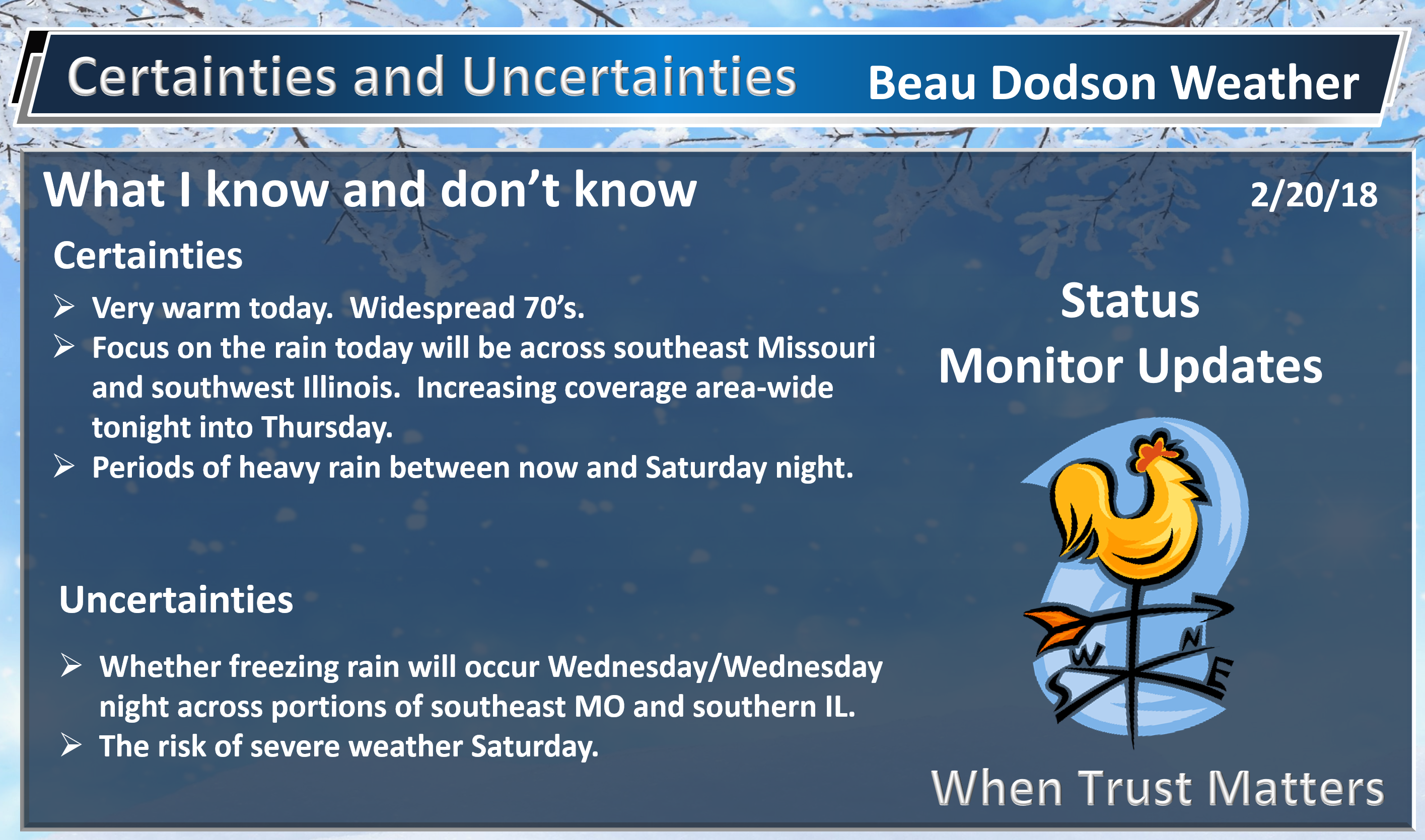
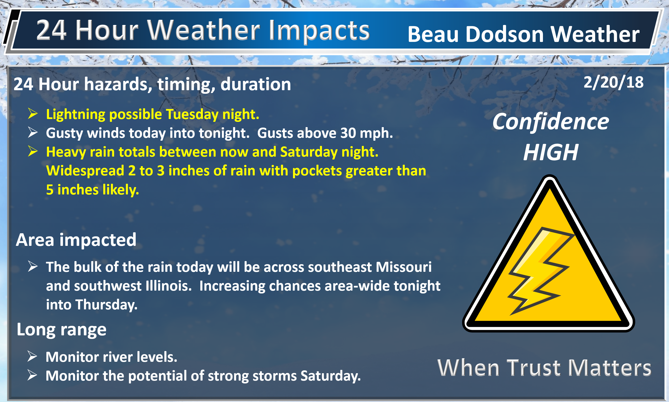
February 20, 2018
Tuesday Forecast Details
Forecast: A mix of sun and clouds. Warm. A chance of showers and perhaps a thunderstorm, mainly over southeast Missouri. A few scattered showers elsewhere.
Temperatures: MO ~ 72 to 76 IL ~ 74 to 78 KY ~ 75 to 80
What is the chance of precipitation? MO ~ 40% IL ~ 40% KY ~ 20% TN ~ 20%
Coverage of precipitation: Widespread over western portions of southeast Missouri. Scattered elsewhere.
Wind chill values: N/A
Accumulating snow or ice: No
Winds: South winds at 15 to 30 mph and gusty.
What impacts are anticipated from the weather? Wet roadways. Perhaps lightning.
My confidence in the forecast verifying: High
Is severe weather expected? Unlikely. Isolated strong storms near Poplar Bluff, MO into south central MO.
The NWS defines severe weather as 58 mph wind or great, 1″ hail or larger, and/or tornadoes
Should I cancel my outdoor plans? No, but monitor radars and updates.
.
We offer regional radars and local city radars – if a radar does not update then try another one. Occasional browsers need their cache cleared. You may also try restarting your browser. This will usually fix any problems.
During the winter you can track snow and ice by clicking the winterize button on the local city view interactive radars.
.

.
.
Tuesday Night Forecast Details:
Forecast: A flood watch is in effect. A winter weather advisory for northern portions of southeast Missouri and a small portion of southwest Illinois. Patchy fog. Rain likely. Heavy rain possible. A thunderstorm possible. Turning colder northwest to southeast. I will be monitoring temperatures over extreme northern portions of southeast Missouri into Randolph County, Illinois. For now, I have them near freezing. It could be close.
Temperatures: MO ~ 34 to 44 IL ~ 34 to 42 KY ~ 42 to 58 (coldest extreme west vs east)
What is the chance of precipitation? MO ~ 90% IL ~ 90% KY ~ 90% TN ~ 90%
Coverage of precipitation: Becoming widespread
Wind chill values: 25 to 35
Accumulating snow or ice: Monitor updates over extreme northern parts of southeast Missouri into Randolph County, Illinois.
Winds: South and southwest winds becoming west and northwest at 10 to 20 mph with higher gusts likely.
What impacts are anticipated from the weather? Wet roadways. Lightning possible. Locally heavy rain possible.
My confidence in the forecast verifying: High
Is severe weather expected? Isolated strong storms near Poplar Bluff, MO into south central MO.
The NWS defines severe weather as 58 mph wind or great, 1″ hail or larger, and/or tornadoes
Should I cancel my outdoor plans: Have a plan B.
.
February 21, 2018
Wednesday Forecast Details
Forecast: A flood watch is in effect. Patchy fog. Turning colder. High temperatures early in the day and then falling. Rain. Locally heavy rain possible. A chance of freezing rain across northern portions of southeast Missouri and perhaps northwest (around Randolph County, IL) portions of southwest Illinois. Confidence in the freezing rain portion of the forecast is low.
Temperatures: MO ~ 36 to 48 IL ~ 38 to 50 KY ~ 48 to 60 Temperatures should fall through the day as the colder air pushes further into the region.
What is the chance of precipitation? MO ~ 80% IL ~ 80% KY ~ 90% TN ~ 90%
Coverage of precipitation: Widespread
Wind chill values: 28 to 40
Accumulating snow or ice: A chance of freezing rain across northern portions of southeast Missouri and perhaps northwest (around Randolph County, IL) portions of southwest Illinois
Winds: North and northwest at 8 to 16 mph with gusts to 25 mph
What impacts are anticipated from the weather? Wet roadways. Locally heavy rain. Monitor the ice potential across our far northern counties.
My confidence in the forecast verifying: High
Is severe weather expected? No
The NWS defines severe weather as 58 mph wind or great, 1″ hail or larger, and/or tornadoes
Should I cancel my outdoor plans? Have a plan B. Monitor updates.
.
Wednesday Night Forecast Details:
Forecast: A flood watch is in effect. Mostly cloudy. Rain likely. I will again monitor surface temperatures over extreme northern portions of southeast Missouri and the Randolph County area in southern Illinois.
Temperatures: MO ~ 32 to 36 IL ~ 32 to 36 KY ~ 38 to 44
What is the chance of precipitation? MO ~ 60% IL ~ 80% KY ~ 80% TN ~ 80%
Coverage of precipitation: Scattered to widespread
Wind chill values: 26 to 34
Accumulating snow or ice: Monitor updates.
Winds: North and northeast at 10 to 20 mph
What impacts are anticipated from the weather? Wet roadways. Monitor wintry mix potential.
My confidence in the forecast verifying: Medium
Is severe weather expected? No
The NWS defines severe weather as 58 mph wind or great, 1″ hail or larger, and/or tornadoes
Should I cancel my outdoor plans: Have a plan B
.
February 22, 2018
Thursday Forecast Details
Forecast: Partly to mostly cloudy. Showers likely, especially over western Kentucky and northwest Tennessee.
Temperatures: MO ~ 46 to 54 IL ~ 46 to 54 KY ~ 50 to 56
What is the chance of precipitation? MO ~ 30% IL ~ 30% KY ~ 60% TN ~ 60%
Coverage of precipitation: Perhaps scattered over southeast Missouri and southern Illinois. A bit more coverage over western Kentucky and western Tennessee.
Wind chill values: N/A
Accumulating snow or ice: No
Winds: North and northeast at 7 to 14 mph
What impacts are anticipated from the weather? Wet roadways.
My confidence in the forecast verifying: Medium
Is severe weather expected? No
The NWS defines severe weather as 58 mph wind or great, 1″ hail or larger, and/or tornadoes
Should I cancel my outdoor plans? No, but monitor radars
.
Thursday Night Forecast Details:
Forecast: Cloudy. Rain re-developing area-wide.
Temperatures: MO ~ 42 to 46 IL ~ 40 to 45 KY ~ 42 to 46
What is the chance of precipitation? MO ~ 70% IL ~ 70% KY ~ 70% TN ~ 70%
Coverage of precipitation: Increasing coverage overnight. Becoming widespread.
Wind chill values: 30’s and 40’s
Accumulating snow or ice: No
Winds: East and northeast winds at 6 to 12 mph
What impacts are anticipated from the weather? Wet roadways.
My confidence in the forecast verifying: Medium
Is severe weather expected? No
The NWS defines severe weather as 58 mph wind or great, 1″ hail or larger, and/or tornadoes
Should I cancel my outdoor plans: Have a plan B
.
February 23, 2018
Friday Forecast Details
Forecast: Cloudy. Rain showers.
Temperatures: MO ~ 56 to 62 IL ~ 56 to 60 KY ~ 60 to 65
What is the chance of precipitation? MO ~ 70% IL ~ 70% KY ~ 70% TN ~ 70%
Coverage of precipitation: Scattered to perhaps widespread
Wind chill values: N/A
Accumulating snow or ice: No
Winds: South and southwest at 7 to 14 mph with gusts to 18 mph
What impacts are anticipated from the weather? Wet roadways.
My confidence in the forecast verifying: Medium
Is severe weather expected? No
The NWS defines severe weather as 58 mph wind or great, 1″ hail or larger, and/or tornadoes
Should I cancel my outdoor plans? Monitor updates
.
Friday Night Forecast Details:
Forecast: Cloudy. Showers and thunderstorms possible.
Temperatures: MO ~ 42 to 46 IL ~ 42 to 46 KY ~ 42 to 46
What is the chance of precipitation? MO ~ 60% IL ~ 60% KY ~ 60% TN ~ 60%
Coverage of precipitation: Scattered to perhaps widespread.
Wind chill values: N/A
Accumulating snow or ice: No
Winds: South winds at 6 to 12 mph with gusts to 20 mph
What impacts are anticipated from the weather? Wet roadways. Lightning.
My confidence in the forecast verifying: Medium
Is severe weather expected? No
The NWS defines severe weather as 58 mph wind or great, 1″ hail or larger, and/or tornadoes
Should I cancel my outdoor plans? Monitor updates
.
February 24, 2018
Saturday Forecast Details
Forecast: Partly to mostly cloudy. Warm. Windy. Showers and thunderstorms likely. A few storms could produce gusty winds.
Temperatures: MO ~ 60 to 65 IL ~ 60 to 65 KY ~ 60 to 65
What is the chance of precipitation? MO ~ 60% IL ~ 60% KY ~ 60% TN ~ 60%
Coverage of precipitation: Numerous
Wind chill values: N/A
Accumulating snow or ice: No
Winds: South and southwest at 10 to 20 mph with higher gusts
What impacts are anticipated from the weather? Wet roadways. Lightning. Some strong storms possible.
My confidence in the forecast verifying: Medium
Is severe weather expected? Strong storms are possible. Monitor updates.
The NWS defines severe weather as 58 mph wind or great, 1″ hail or larger, and/or tornadoes
Should I cancel my outdoor plans? Monitor updates
.
Saturday Night Forecast Details:
Forecast: Cloudy. Showers and thunderstorms in the evening. Turning colder.
Temperatures: MO ~ 38 to 44 IL ~ 40 to 45 KY ~ 42 to 46
What is the chance of precipitation? MO ~ 60% IL ~ 60% KY ~ 60% TN ~ 60%
Coverage of precipitation: Numerous
Wind chill values: N/A
Accumulating snow or ice: No
Winds: South winds at 6 to 12 mph with gusts to 20 mph. Winds becoming west and northwest at 10 to 20 mph.
What impacts are anticipated from the weather? Wet roadways. Lightning. A few storms could be strong.
My confidence in the forecast verifying: Medium
Is severe weather expected? Strong storms are possible. Monitor updates.
The NWS defines severe weather as 58 mph wind or great, 1″ hail or larger, and/or tornadoes
Should I cancel my outdoor plans: Monitor updates
.
February 25, 2018
Sunday Forecast Details
Forecast: Partly sunny. Cooler.
Temperatures: MO ~ 54 to 58 IL ~ 54 to 58 KY ~ 54 to 58
What is the chance of precipitation? MO ~ 0% IL ~ 0% KY ~ 0% TN ~ 0%
Coverage of precipitation: None
Wind chill values: N/A
Accumulating snow or ice: No
Winds: West and northwest at 10 to 20 mph
What impacts are anticipated from the weather? None
My confidence in the forecast verifying: Medium
Is severe weather expected? No.
The NWS defines severe weather as 58 mph wind or great, 1″ hail or larger, and/or tornadoes
Should I cancel my outdoor plans? No
.
Sunday Night Forecast Details:
Forecast: Mostly clear. Patchy fog.
Temperatures: MO ~ 36 to 42 IL ~ 36 to 42 KY ~ 36 to 42
What is the chance of precipitation? MO ~ 0% IL ~ 0% KY ~ 0% TN ~ 0%
Coverage of precipitation: None
Wind chill values: N/A
Accumulating snow or ice: No
Winds: North 5 mph with gusts to 10 mph
What impacts are anticipated from the weather? None
My confidence in the forecast verifying: Medium
Is severe weather expected? No
The NWS defines severe weather as 58 mph wind or great, 1″ hail or larger, and/or tornadoes
Should I cancel my outdoor plans: No
.
February 26, 2018
Monday Forecast Details
Forecast: Partly sunny. Cool.
Temperatures: MO ~ 54 to 58 IL ~ 54 to 58 KY ~ 54 to 58
What is the chance of precipitation? MO ~ 0% IL ~ 0% KY ~ 0% TN ~ 0%
Coverage of precipitation: None
Wind chill values: N/A
Accumulating snow or ice: No
Winds: East and northeast at 10 mph
What impacts are anticipated from the weather? None
My confidence in the forecast verifying: Medium
Is severe weather expected? No
The NWS defines severe weather as 58 mph wind or great, 1″ hail or larger, and/or tornadoes
Should I cancel my outdoor plans? No
.
Monday Night Forecast Details:
Forecast: A few passing clouds. Cool. Patchy fog.
Temperatures: MO ~ 36 to 42 IL ~ 36 to 42 KY ~ 36 to 42
What is the chance of precipitation? MO ~ 0% IL ~ 0% KY ~ 0% TN ~ 0%
Coverage of precipitation: None
Wind chill values: N/A
Accumulating snow or ice: No
Winds: North 5 mph
What impacts are anticipated from the weather? None
My confidence in the forecast verifying: Medium
Is severe weather expected? No
The NWS defines severe weather as 58 mph wind or great, 1″ hail or larger, and/or tornadoes
Should I cancel my outdoor plans: No
.

.
Tuesday through Wednesday: Winter weather is not anticipated. I am monitoring late Tuesday night into Wednesday night for freezing rain. The most likely location of the freezing rain would be the northern parts of southeast Missouri and then towards Randolph County, Illinois. Even there, confidence is low in the eventual forecast outcome. Monitor updates as I fine tune the forecast.
.

.
The National Weather Service definition of a severe thunderstorm is one that produces quarter size hail or larger, 58 mph winds or greater, and/or a tornado.
Tuesday through Friday: Monitor updates. On and off thunderstorms chances are possible. At this time, the severe weather risk appears low. Lightning will be the main concern. Heavy rain will be a concern. Between now and Saturday, rainfall totals of one to four inches will be possible. Locally higher totals possible. Monitor updates.
An isolated strong storm is possible today across south central Missouri. That would include Butler County, MO and then westward a county or two. Overall, the risk is low for oranized severe weather. Monitor updates.
Saturday and Saturday night: Monitor updates. Stronger storms are possible during this time frame.
.

.
The daily outlook can be found at the bottom of this post.
.
.
We offer regional radars and local city radars – if a radar does not update then try another one. Occasional browsers need their cache cleared. You may also try restarting your browser. This will usually fix any problems.
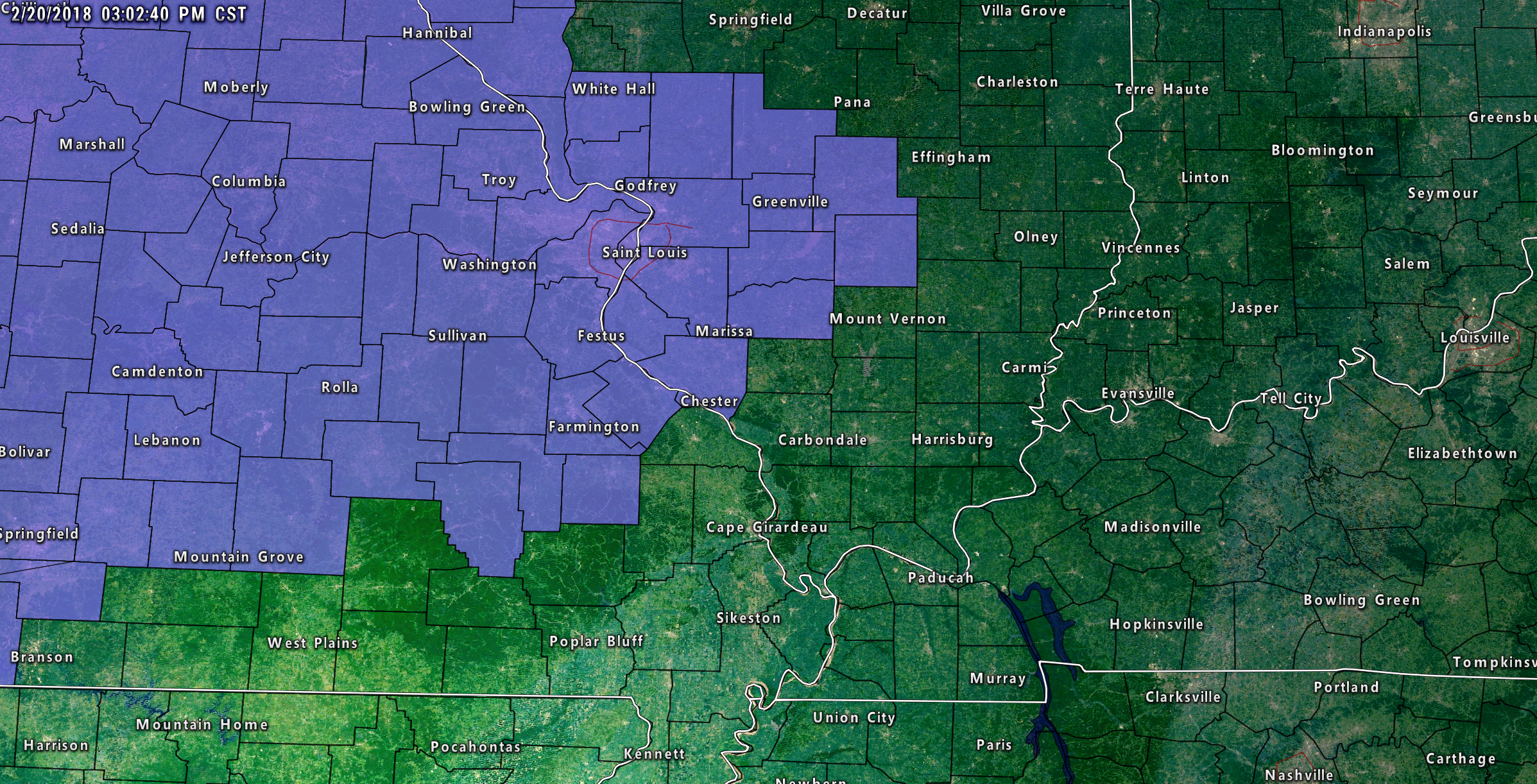
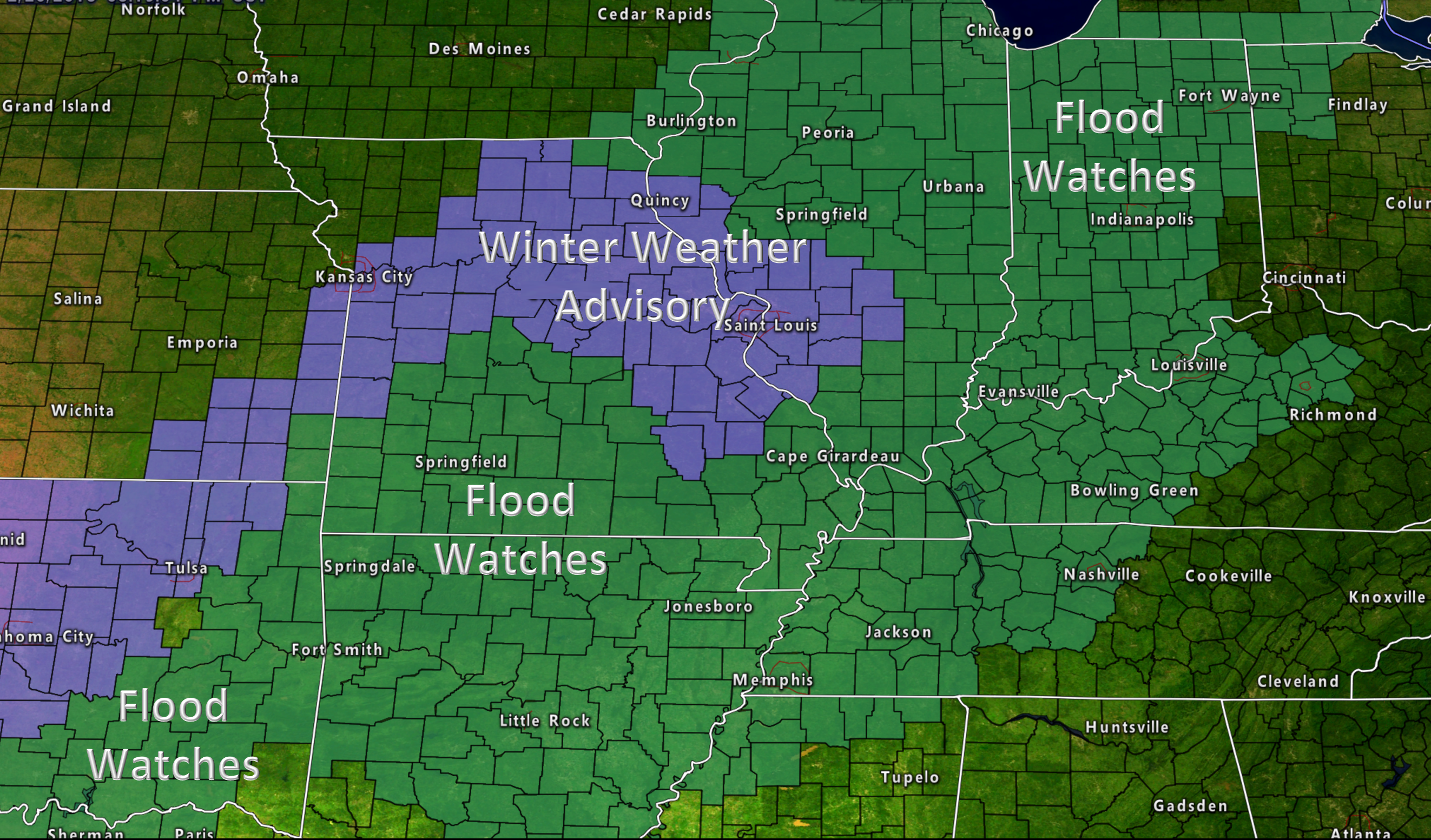
A winter weather advisory has been issued for portions of the region. This advisory extends from 12 AM tonight until 12 PM Wednesday. Freezing rain is the main concern. Blue/purple zone is the advisory.
.
. .
.
.
A flood watch blankets a huge portion of the central United States. Flood watch in green. The watch covers our entire area through Wednesday night (and likely into Saturday night).
.
.
.
.
.
Forecast:
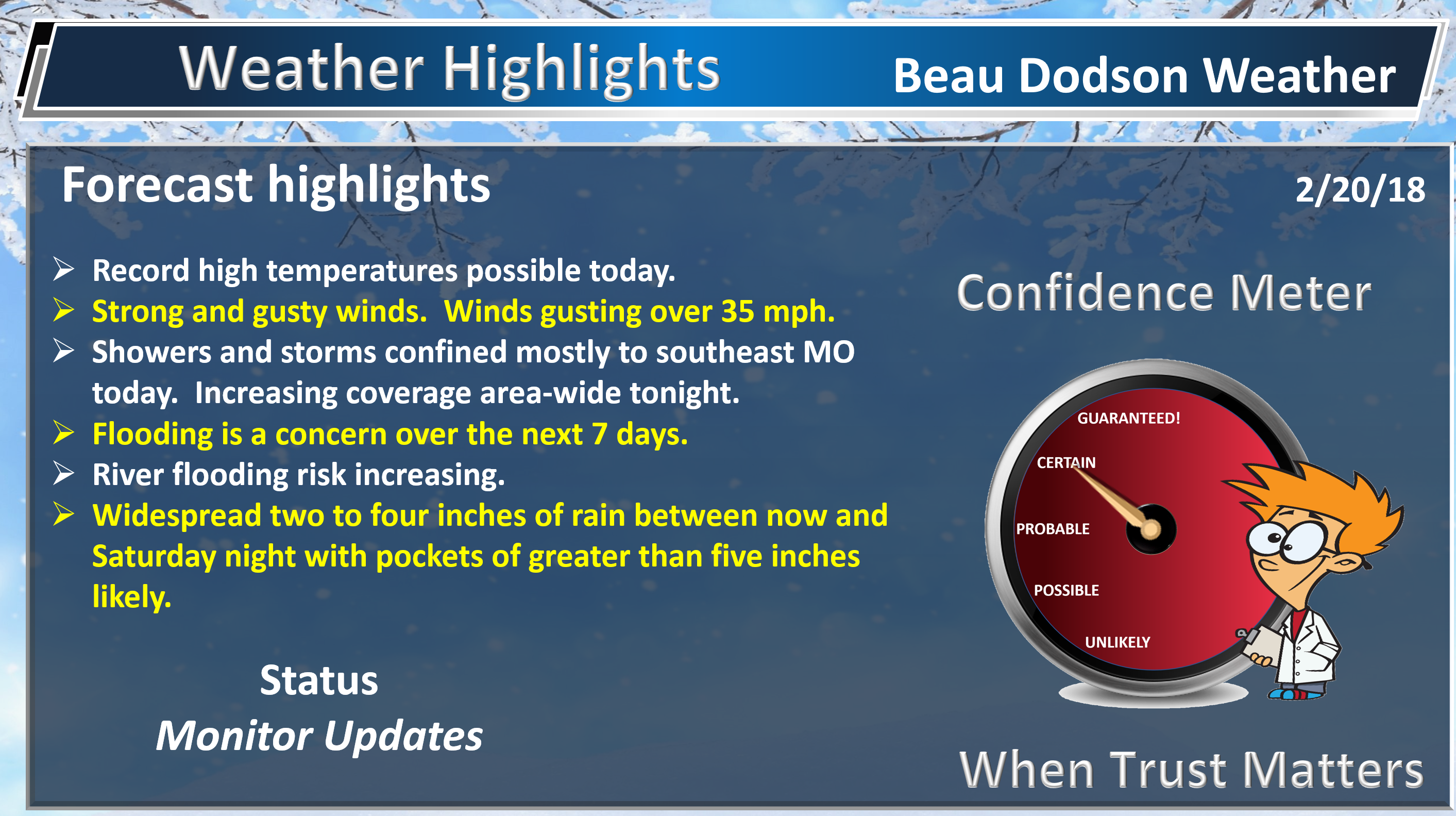
HIGHLIGHTS
- Active weather through Saturday night. On and off rain chances.
- Record high temperatures possible today.
- Locally heavy rain is a concern this week.
- The placement of the cold front will be key to when you experience the greatest chance of rain
- I am monitoring Wednesday into Thursday for freezing rain. This would most likely be across portions of the Missouri Ozarks and then northeast towards Mt Vernon, Illinois. Confidence remains low on this portion of the forecast.
- I am monitoring Saturday for strong thunderstorms. Still a bit early for certainties.
High confidence today and tonight.
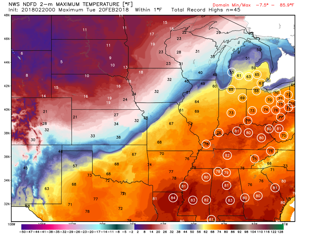
Warm and windy today! High temperatures may break all-time February records!
Here is the map showing where a few records may be broken. The white circled stations are where records may fall (other areas, as well). This map just shows you some of the key reporting stations.
The Ohio Valley is going to be warm. You can expect widespread 70’s today. I can’t rule out someone touching 80 degrees (if we can avoid clouds).
Can you find the cold front? I bet you can! Much colder air to the northwest of our region. Check out the single digits in South Dakota.
This clash of air masses is going to fuel widespread rain and thunderstorm chances in our region. Ice will be possible in the cold sector of the system.
.
.
An active weather pattern is underway. We will have multiple rounds of showers and thunderstorms between now and Saturday night.
Generally, a lot of rain is going to fall across our region over the coming days. Rivers, in some counties, are already high. This rain will aggravate the situation. There will be substantial rises on large rivers. If you live by a river or have river interests then be sure and monitor updated crest information.
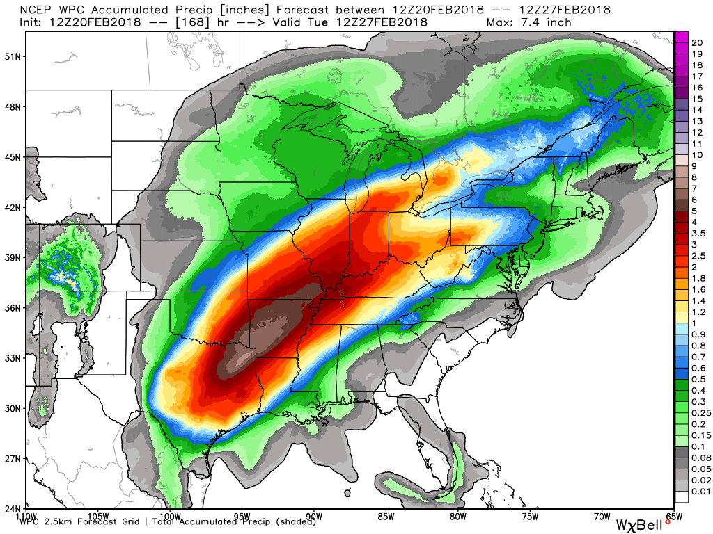
Between now and Saturday night you can expect a widespread two to three inches of rain. Pockets of greater than five inches of rain likely.
Check out the seven-day rain forecast from the WPC/NOAA. The widespread nature of this event will mean water basins will be soaked.
Click images to enlarge them
.
.
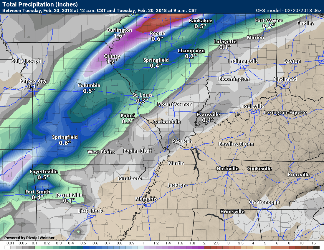
Let’s break that down into days.
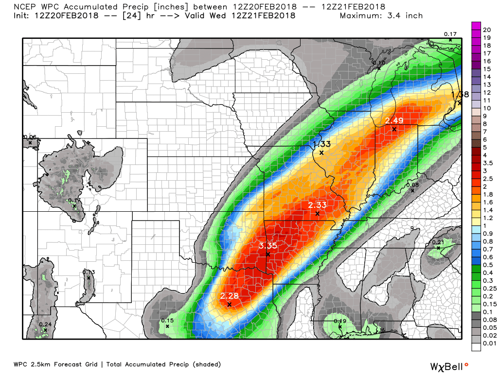
Here are the forecast rainfall totals from 6 AM Tuesday through 6 AM Wednesday
.
.
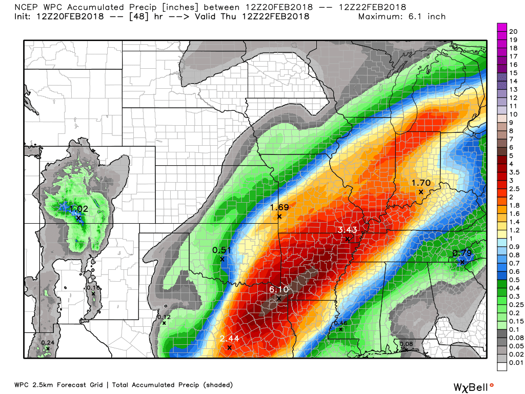
Here are the forecast rainfall totals from 6 AM Tuesday through 6 AM Thursday.
.
.
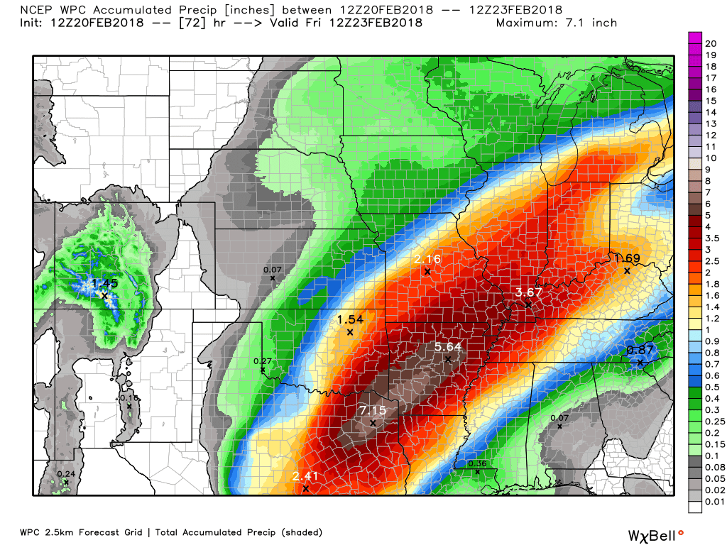
Here are the forecast rainfall totals from 6 AM Tuesday through 6 AM Friday.
.
.
Additional rain will fall Friday night into Saturday night. Locally heavy rain.
The good news is that severe weather is unlikely today through Friday. Lightning will be possible from time to time.
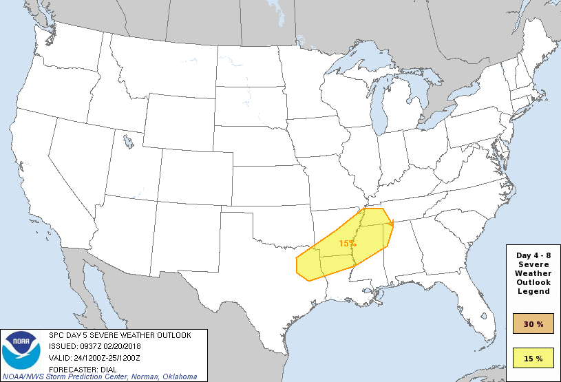
I am closely monitoring Saturday for stronger thunderstorms. The dynamics should be stronger Saturday. Monitor updates concerning that part of the forecast.
The Storm Prediction Center has outlined an area to our south for the possibility of severe storms Saturday afternoon and night. This may shift around. Monitor updates, as always.
This area in yellow is the day five severe weather outlook. Again, this may shift around.
.
.
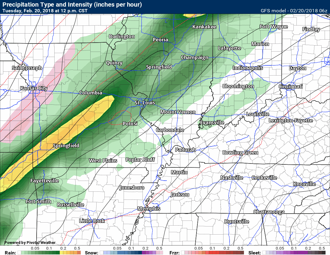
Let’s check out some future-cast radar images from some of the models.
The timestamp can be found in the upper left portion of the graphic.
Green and yellow/orange represent rain. Blue is snow. Purple, pink, and red represent freezing rain.
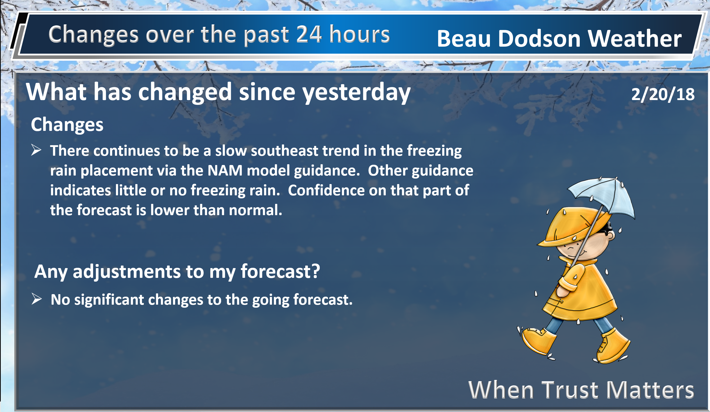
There is quite a bit of debate about the freezing rain placement in the NAM model guidance. This will need to be monitored. There may be a small window of time when freezing rain could occur over northern parts of southeast Missouri and northwestern parts of southern Illinois.
This first model is the high-resolution 3K NAM.
This is one model’s opinion. Other models may disagree. Model’s are for guidance and are not gospel. Typically, no one model is 100% correct. It normally takes a blend of model guidance to put together a forecast.
.
.
Here is what the 3K NAM paints for rain totals through 12 PM Thursday
.
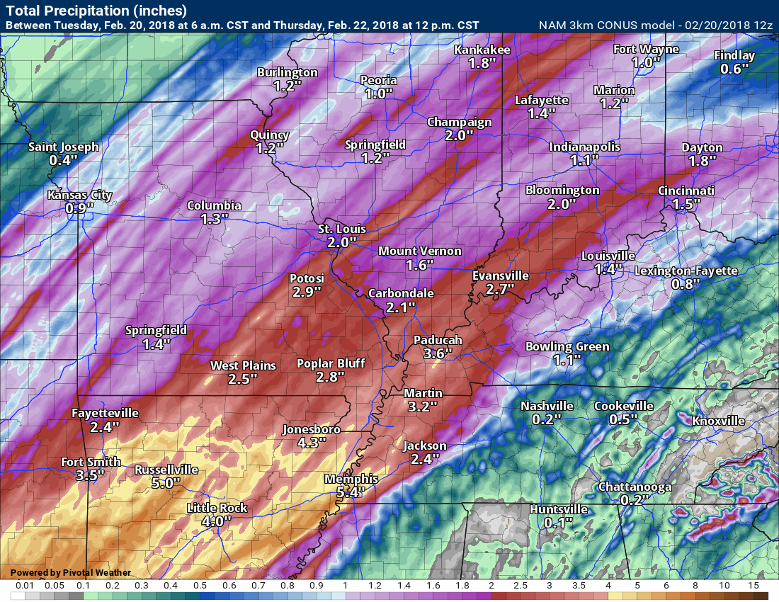
.
This model is the GFS guidance. The GFS goes out further in time. Again, the time stamp is located in the upper left portion of the graphic.
Several rounds of rain likely between now and Saturday night.
.
.
The GFS rainfall totals are more substantial because it goes out further in time. This covers today through next Sunday night.
The GFS spits out some extreme numbers. Confidence in numbers above the five-inch mark remains low.
I am confident a widespread two to three inches of rain will fall with pockets of five inches (or more).
.
.
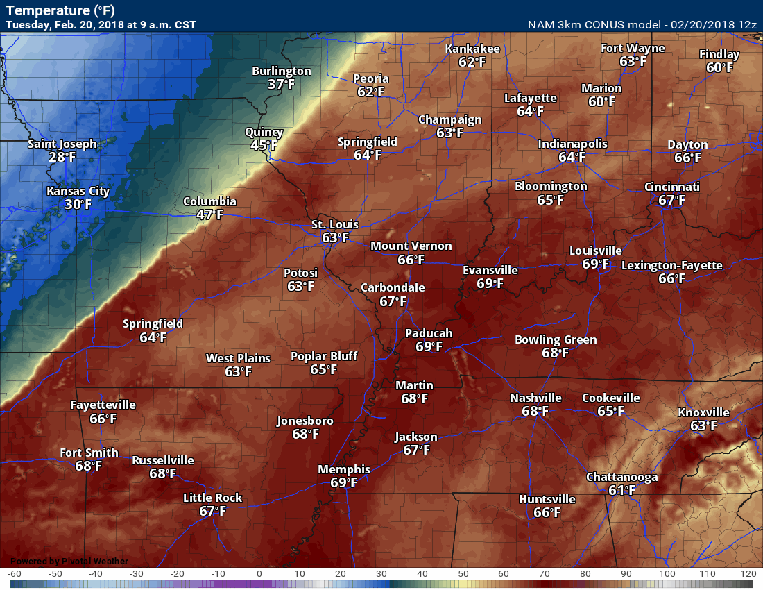
Check out this temperature graphic. Warm! You can watch the cold front push through the region Tuesday night into Wednesday. The warmer air is pushed off to our east. You knew those temperatures couldn’t last.
Here is the GFS model guidance temperature forecast. Timestamp upper left.
This is for today through Thursday morning.
.
.
Gusty winds are likely today into Wednesday. Winds may gust above 35 mph.
We will need to monitor river stages. Rivers are going to rise over the coming weeks.
.
We will need to monitor river stages. Rivers are going to rise over the coming weeks.
.

.
The preliminary summer forecast has been posted on the subscription website. Subscribe at www.beaudodsonweather.com
Summer outlook – Click here
.


We offer regional radars and local city radars – if a radar does not update then try another one. Occasional browsers need their cache cleared. You may also try restarting your browser. This will usually fix any problems.
During the winter you can track snow and ice by clicking the winterize button on the local city view interactive radars.
You may email me at beaudodson@usawx.com
Interactive Weather Radar Page. Choose the city nearest your location: Click this link
National interactive radar: Click this link.