This is what you are missing out on if you are not a $3 a month subscriber!
- Daily forecast texts from my computer to your app/cell phone
- Severe weather app/text alerts from my keyboard to your app/cell phone
- Social media links sent directly to your app/cell phone. When I update the blog, videos, or Facebook you will receive the link.
- Missouri Valley centered video updates
- Ohio Valley centered video updates
- Long-range video updates
- Week one temperature and precipitation outlook
- Week two temperature and precipitation outlook
- Week three and four temperature and precipitation outlook
- Monthly outlooks
Monthly operating costs for Weather Talk can top $2000.00. Your $3 subscription helps pay for those costs. I work for you.
.

.
Your $3 per month also helps support these local charity projects.
.

.

.
Interactive Weather Radar Page. Choose the city nearest your location: Click this link.
February 18, 2018
Sunday afternoon Forecast Details
Forecast: Partly to mostly sunny. Any remaining fog will mix out. A 20% of a shower across southeast Missouri and southwest Illinois after 4 pm. Mild temperatures.
Temperatures: MO ~ 53 to 58 IL ~ 53 to 56 KY ~ 54 to 58
What is the chance of precipitation? MO ~ 20% IL ~ 20% KY ~ 0% TN ~ 10%
Coverage of precipitation: None to isolated (after 4 PM)
Wind chill values: N/A
Accumulating snow or ice: No
Winds: South and southeast winds at 5 to 10 mph with gusts to 18 mph
What impacts are anticipated from the weather? Most likely none
My confidence in the forecast verifying: High
Is severe weather expected? No
The NWS defines severe weather as 58 mph wind or great, 1″ hail or larger, and/or tornadoes
Should I cancel my outdoor plans? No
.
Sunday Night Forecast Details:
Forecast: Becoming cloudy. Rising temperatures overnight. Scattered evening showers. Rain likely as the night wears on. Greatest chances over southeast Missouri vs the Pennyrile area of western Kentucky. A thunderstorm possible. Windy. Mild.
Temperatures: MO ~ 50 to 55 IL ~ 53 to 56 KY ~ 52 to 56
What is the chance of precipitation? MO ~ 70% IL ~ 70% KY ~ 60% TN ~ 60%
Coverage of precipitation: Scattered to widespread
Wind chill values: N/A
Accumulating snow or ice: No
Winds: South and southwest winds at 10 to 20 mph. Gusty, at times.
What impacts are anticipated from the weather? Wet roadways. Perhaps lightning.
My confidence in the forecast verifying: High
Is severe weather expected? No.
The NWS defines severe weather as 58 mph wind or great, 1″ hail or larger, and/or tornadoes
Should I cancel my outdoor plans: No, but monitor radars.
.
February 19, 2018
Monday Forecast Details
Forecast: A mix of sun and clouds. Scattered rain showers. A thunderstorm possible. Breezy and mild. Best rain chances over southeast Missouri and then lesser chances the further east you drive.
Temperatures: MO ~ 68 to 74 IL ~ 66 to 72 KY ~ 68 to 74
What is the chance of precipitation? MO ~ 60% IL ~ 40% KY ~ 30% TN ~ 30%
Coverage of precipitation: Scattered
Wind chill values: N/A
Accumulating snow or ice: No
Winds: South at 15 to 30 mph. Gusty winds.
What impacts are anticipated from the weather? Wet roadways. Perhaps lightning.
My confidence in the forecast verifying: High
Is severe weather expected? No
The NWS defines severe weather as 58 mph wind or great, 1″ hail or larger, and/or tornadoes
Should I cancel my outdoor plans? No, but monitor radars.
.
Monday Night Forecast Details:
Forecast: Cloudy. Scattered rain showers. Mild.
Temperatures: MO ~ 56 to 62 IL ~ 56 to 62 KY ~ 56 to 62
What is the chance of precipitation? MO ~ 40% IL ~ 30% KY ~ 30% TN ~ 30%
Coverage of precipitation: Scattered over most of the area. Greatest coverage over southeast Missouri.
Wind chill values: N/A
Accumulating snow or ice: No
Winds: South and southwest winds at 15 to 30 mph and gusty
What impacts are anticipated from the weather? Wet roadways. I will monitor thunderstorm chances.
My confidence in the forecast verifying: Medium
Is severe weather expected? No
The NWS defines severe weather as 58 mph wind or great, 1″ hail or larger, and/or tornadoes
Should I cancel my outdoor plans: No, but monitor radars.
.
February 20, 2018
Tuesday Forecast Details
Forecast: A mix of sun and clouds. Rain chances increasing west to east. A thunderstorm possible. Warm. Breezy.
Temperatures: MO ~ 72 to 76 IL ~ 72 to 76 KY ~ 72 to 76
What is the chance of precipitation? MO ~ 60% IL ~ 60% KY ~ 40% TN ~ 40%
Coverage of precipitation: Scattered to perhaps widespread
Wind chill values: N/A
Accumulating snow or ice: No
Winds: South winds at 12 to 24 mph and gusty.
What impacts are anticipated from the weather? Wet roadways. Perhaps lightning.
My confidence in the forecast verifying: Medium
Is severe weather expected? Monitor updates
The NWS defines severe weather as 58 mph wind or great, 1″ hail or larger, and/or tornadoes
Should I cancel my outdoor plans? No, but monitor radars and updates.
.
Tuesday Night Forecast Details:
Forecast: Rain likely. Heavy rain possible. A thunderstorm possible. Turning colder northwest to southeast.
Temperatures: MO ~ 34 to 44 IL ~ 34 to 42 KY ~ 42 to 54 (coldest extreme west vs east)
What is the chance of precipitation? MO ~ 80% IL ~ 80% KY ~ 80% TN ~ 80%
Coverage of precipitation: Widespread
Wind chill values: 25 to 35
Accumulating snow or ice: No
Winds: Southwest winds becoming west and northwest at 10 to 20 mph with higher gusts likely.
What impacts are anticipated from the weather? Wet roadways. Lightning possible. Locally heavy rain possible.
My confidence in the forecast verifying: Medium
Is severe weather expected? Monitor updates
The NWS defines severe weather as 58 mph wind or great, 1″ hail or larger, and/or tornadoes
Should I cancel my outdoor plans: No, but monitor updates.
.
February 21, 2018
Wednesday Forecast Details
Forecast: Turning colder. High temperatures early in the day and then falling. Mostly cloudy. Rain showers likely. Locally heavy rain possible.
Temperatures: MO ~ 36 to 44 IL ~ 40 to 50 KY ~ 50 to 60
What is the chance of precipitation? MO ~ 60% IL ~ 60% KY ~ 70% TN ~ 70%
Coverage of precipitation: Scattered
Wind chill values: 35 to 45
Accumulating snow or ice: No
Winds: North and northwest at 8 to 16 mph with gusts to 25 mph
What impacts are anticipated from the weather? Wet roadways. Locally heavy rain.
My confidence in the forecast verifying: Medium
Is severe weather expected? No
The NWS defines severe weather as 58 mph wind or great, 1″ hail or larger, and/or tornadoes
Should I cancel my outdoor plans? Have a plan B. Monitor updates.
.
Wednesday Night Forecast Details:
Forecast: Mostly cloudy. Showers likely. A wintry mix possible.
Temperatures: MO ~ 32 to 36 IL ~ 32 to 36 KY ~ 38 to 44
What is the chance of precipitation? MO ~ 40% IL ~ 40% KY ~ 60% TN ~ 60%
Coverage of precipitation:
Wind chill values: N/A
Accumulating snow or ice: Monitor updates.
Winds: North and northeast at 10 to 20 mph
What impacts are anticipated from the weather? Wet roadways. Monitor wintry mix potential.
My confidence in the forecast verifying: LOW
Is severe weather expected? No
The NWS defines severe weather as 58 mph wind or great, 1″ hail or larger, and/or tornadoes
Should I cancel my outdoor plans: Monitor updates
.
February 22, 2018
Thursday Forecast Details
Forecast: Partly cloudy.
Temperatures: MO ~ 46 to 54 IL ~ 46 to 54 KY ~ 46 to 54
What is the chance of precipitation? MO ~ 10% IL ~ 10% KY ~ 30% TN ~ 30%
Coverage of precipitation: Perhaps scattered.
Wind chill values: N/A
Accumulating snow or ice: No
Winds: North at 7 to 14 mph
What impacts are anticipated from the weather? Wet roadways.
My confidence in the forecast verifying: Medium
Is severe weather expected? No
The NWS defines severe weather as 58 mph wind or great, 1″ hail or larger, and/or tornadoes
Should I cancel my outdoor plans? No
.
Thursday Night Forecast Details:
Forecast: Cloudy. Showers developing.
Temperatures: MO ~ 36 to 42 IL ~ 36 to 42 KY ~ 36 to 42
What is the chance of precipitation? MO ~ 40% IL ~ 40% KY ~ 30% TN ~ 30%
Coverage of precipitation: Scattered, but perhaps increasing as the night wears on
Wind chill values: 30’s
Accumulating snow or ice: No
Winds: East and northeast winds at 6 to 12 mph
What impacts are anticipated from the weather? Wet roadways.
My confidence in the forecast verifying: Medium
Is severe weather expected? No
The NWS defines severe weather as 58 mph wind or great, 1″ hail or larger, and/or tornadoes
Should I cancel my outdoor plans: Monitor updates
.
February 23, 2018
Friday Forecast Details
Forecast: Cloudy. Rain showers.
Temperatures: MO ~ 53 to 56 IL ~ 53 to 56 KY ~ 53 to 56
What is the chance of precipitation? MO ~ 40% IL ~ 40% KY ~ 40% TN ~ 40%
Coverage of precipitation:
Wind chill values: N/A
Accumulating snow or ice: No
Winds: East at 7 to 14 mph
What impacts are anticipated from the weather? Wet roadways.
My confidence in the forecast verifying: Medium
Is severe weather expected? No
The NWS defines severe weather as 58 mph wind or great, 1″ hail or larger, and/or tornadoes
Should I cancel my outdoor plans? No
.
Friday Night Forecast Details:
Forecast: Cloudy. Showers possible.
Temperatures: MO ~ 36 to 42 IL ~ 36 to 42 KY ~ 36 to 42
What is the chance of precipitation? MO ~ 40% IL ~ 40% KY ~ 40% TN ~ 40%
Coverage of precipitation:
Wind chill values: N/A
Accumulating snow or ice: No
Winds: East and northeast winds at 6 to 12 mph
What impacts are anticipated from the weather? Wet roadways.
My confidence in the forecast verifying: Medium
Is severe weather expected? No
The NWS defines severe weather as 58 mph wind or great, 1″ hail or larger, and/or tornadoes
Should I cancel my outdoor plans: Monitor updates
.

.
Saturday morning: Heavy wet snowflakes across portions of southeast Missouri and southern Illinois. A slushy inch or two possible, before changing to rain. Use care on slushy/snow covered roads.
Sunday through Wednesday: Winter weather is not anticipated.
.

.
The National Weather Service definition of a severe thunderstorm is one that produces quarter size hail or larger, 58 mph winds or greater, and/or a tornado.
Now through Sunday afternoon: Severe weather is not anticipated.
Sunday night through Thursday: Monitor updates. On and off thunderstorms chances are possible. Very heavy rain is likely from time to time. Flooding is also a concern.
.

.
The daily outlook can be found at the bottom of this post.
.

.
We offer regional radars and local city radars – if a radar does not update then try another one. Occasional browsers need their cache cleared. You may also try restarting your browser. This will usually fix any problems.
During the winter you can track snow and ice by clicking the winterize button on the local city view interactive radars.
Saturday Update:
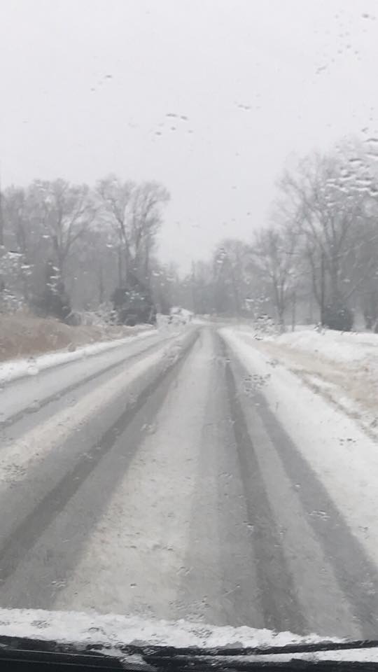
Snow is falling across portions of southeast Missouri and southern Illinois. Slushy accumulation is being reported in some areas.
Here is a photograph from Candice Sauerbrunn. This was between Cobden and Anna, Illinois.
.
.
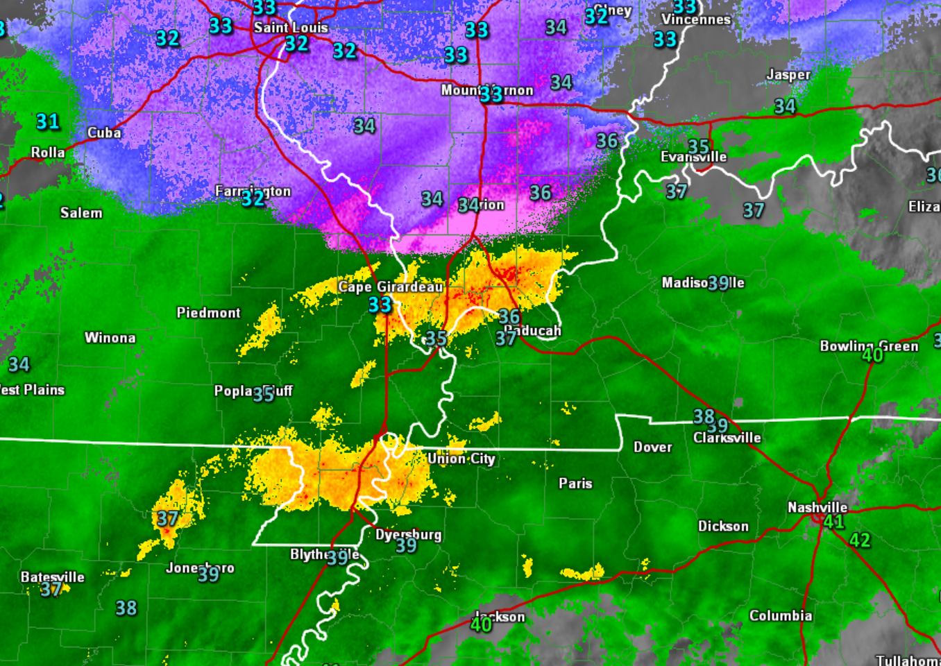
This is a great radar to track the rain/snow. Blue, pink, and purple is the snow. Green, yellow, and red represent rain.
Link to this radar
http://weatherobservatory.com/radar_grearth1.htm
.
.
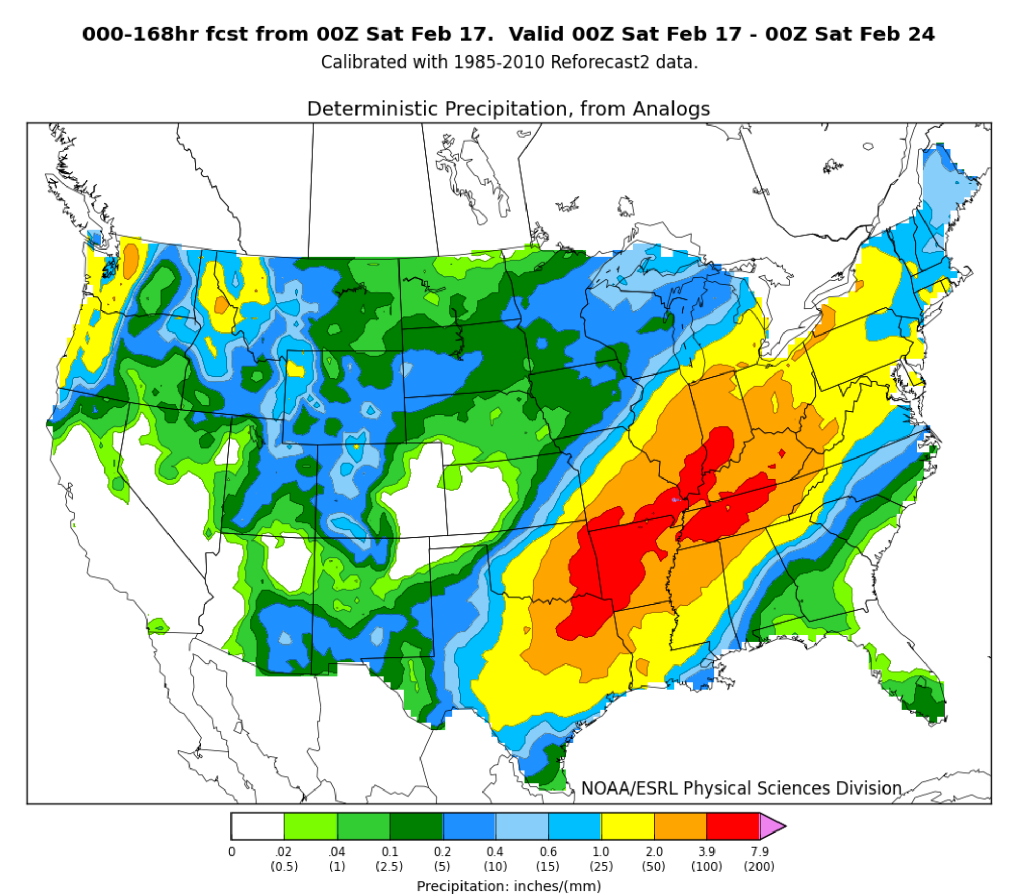
Heavy Rain Next Week:
There is the potential of heavy rain next week. Several rounds of rain are likely. Model guidance continues to indicate that several inches of rain may fall in the Ohio and Tennessee River basins. Monitor updates.
This is an ensemble forecast map.
What are ensembles?
.

.
Want to learn more about ensembles? I posted this link a few weeks ago. Click Here.
This is a strong signal for heavy rain in our region. I would not be surprised if someone tops 5 inches of rain over the coming seven day period of time.
.
.
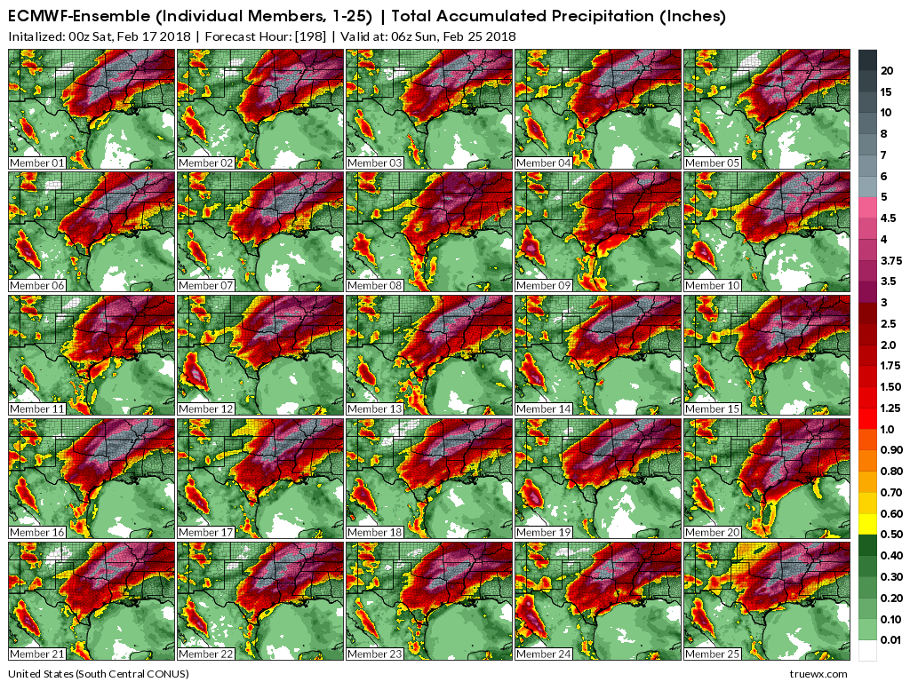
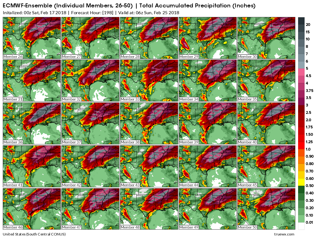
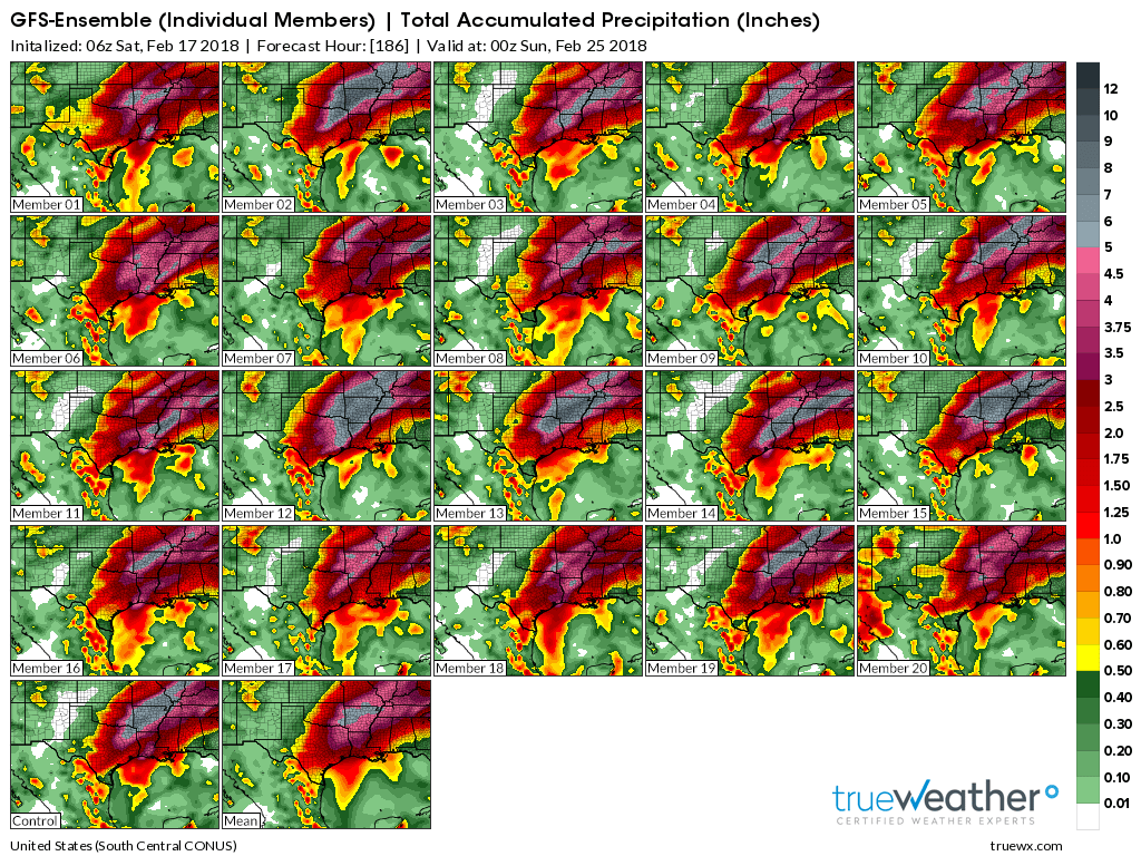
Let me show you some more ensembles. These are three different models. It is amazing to see every model agree on the potential of heavy rain over the coming seven days.
The models are showing some extreme numbers. Does that mean this will happen? There is agreement among the data.
The details, however, will need to be ironed out. There will be some bands of very heavy rain totals with the coming events. Just because these graphics show X amount of rain falling in your county does not mean it will happen.
The point of the graphics: There is agreement among the guidance that a heavy rain event will occur over the coming seven days. Several chances of rain and thunderstorms. The exact placement of the largest rain totals is still an unknown.
CLICK images to enlarge. Scale is on the right side of the page. These are from Truewx.com.
.
EC Ensembles
.
.
GEM Ensembles
.

.
GFS Ensembles
.
.
What does all that mean? It means there is a risk of flooding over the coming week. Monitor updates.
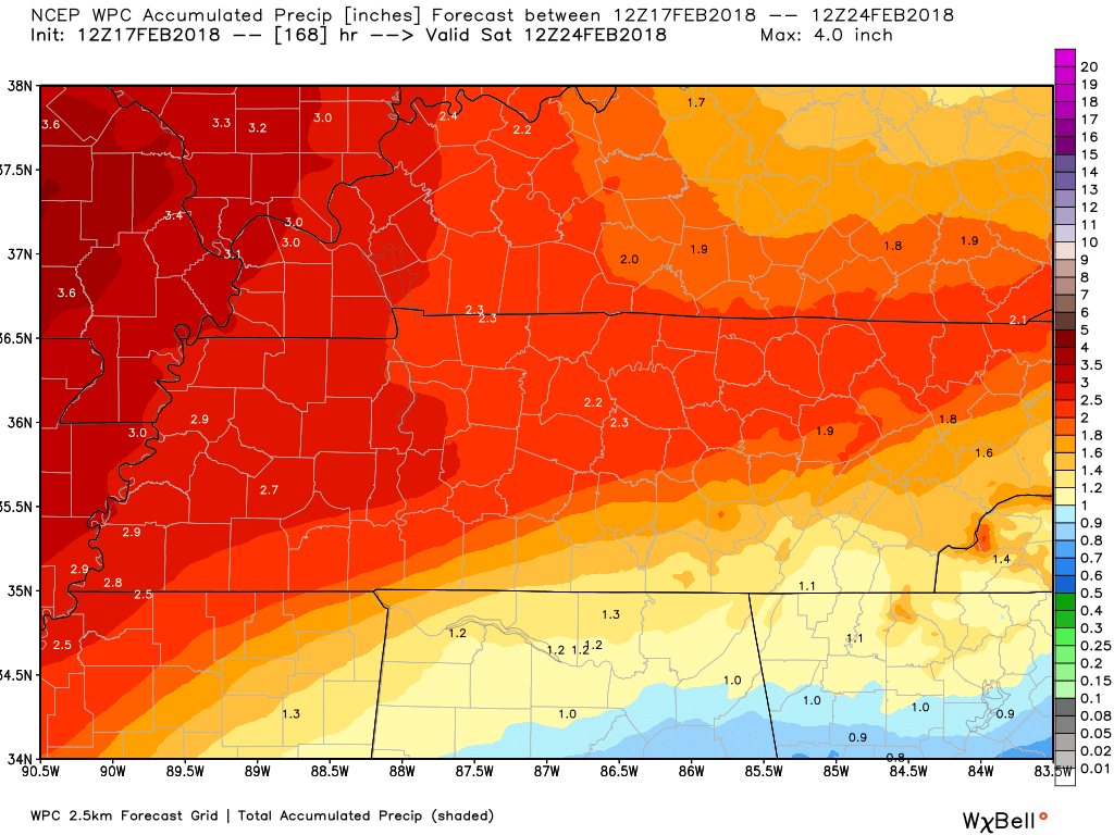
Here is what the WPC/NOAA is forecasting over the next seven days.
Northwest view and southeast view of our local area.
Click to enlarge.
.

.
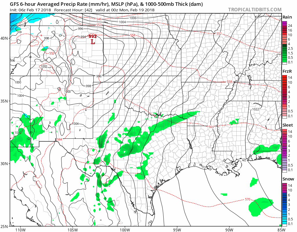
Let’s take a look at the GFS model guidance future-cast radar. This is from Sunday night through next Sunday.
Timestamp upper left.
The big question is whether the front stalls in our region Tuesday and Wednesday. If that occurs, then heavy rain totals would be the end result.
Green, yellow, and red represent rain. Blue is snow.
Timestamp upper left. 0z is 6 PM. 06z is 12 AM. 12z is 6 AM. 18z is 12 PM.
.
.
We will need to monitor river stages. Rivers are going to rise over the coming weeks.
.

.
The preliminary summer forecast has been posted on the subscription website. Subscribe at www.beaudodsonweather.com
Summer outlook – Click here
.


We offer regional radars and local city radars – if a radar does not update then try another one. Occasional browsers need their cache cleared. You may also try restarting your browser. This will usually fix any problems.
During the winter you can track snow and ice by clicking the winterize button on the local city view interactive radars.
You may email me at beaudodson@usawx.com
Interactive Weather Radar Page. Choose the city nearest your location: Click this link
National interactive radar: Click this link.