New numbers
First update today – 9 AM
February 14, 2015: Happy Valentines Day, everyone. An extremely complicated forecast for the next 3 days. This is the most complicated system of the entire winter for our region, thus far. There is VERY little confidence this morning as to what will happen on Sunday afternoon into Tuesday. Below are my current thoughts…
REMEMBER THAT A FORECAST EVOLVES…that means that as new information arrives the forecast is adjusted. If you only read one forecast and then walk away – you might not receive the most up to date information.
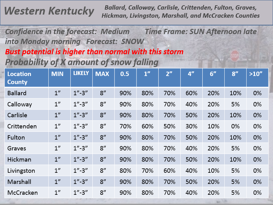
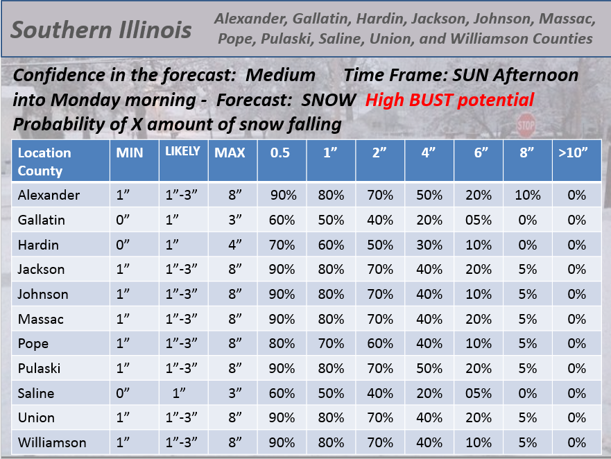
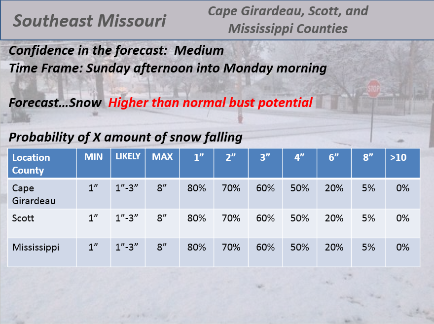
The Sunday afternoon-Monday morning storm has a HIGH bust potential. A bust is what forecasters call a failed forecast. It does not pan out. This is a difficult forecast – all NWS offices agree on that subject! Difficult to pin down where the heaviest snow will fall and where to cut the snow off entirely. There will be a sharp cut off to snow totals somewhere in our region. Some places on Sunday afternoon and Sunday night will receive no measurable snow. Keep that in mind.
Bottom line…
1. Some snow possible today with the front – light accumulation if any. Best chances over northeast counties and east counties.
2. Bitterly cold this afternoon into at least Wednesday.
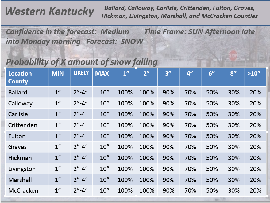
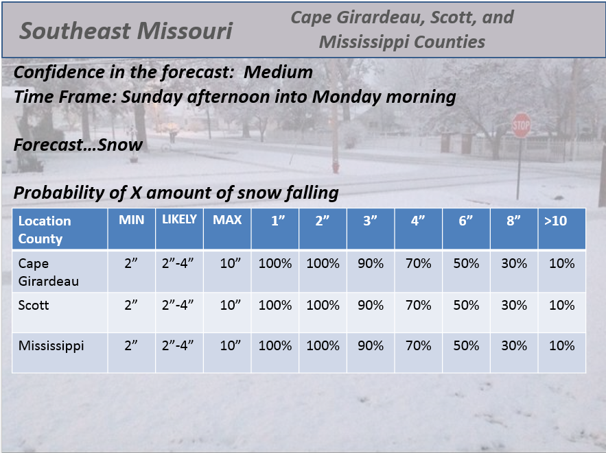
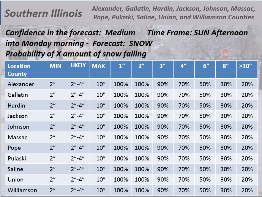
3. Snow possible Sunday late afternoon into Monday night – some accumulation likely – esp south and west of a line from Farmington, MO to northern Pope County, Illinois then east into the Hopkinsville area. North and east of that line some snow is also possible, but likely not as much.
4. Possibly additional snow coming in from the south on Monday/Monday night/Tuesday morning.
Synopsis…
A strong cold front arrives today. Gusty winds, snow showers, falling temperatures, and very low wind chills by late morning into the evening hours. From will move from north to south.
Snowfall accumulations today of a dusting to 1″ or so across some counties – best chance of that happening would be the northeast and eastern half of the region – I would draw a line from Mt Vernon down towards Vienna then down towards or east of Paducah – then east and northeast of there.
Snow flurries and snow showers can occur anywhere in the area today – that is just the best chance of perhaps a quick dusting to 1″ or so. The scattered nature of the snow will prevent everyone from experiencing those numbers.
BITTERLY COLD tonight with chills below zero. Lows by Sunday morning in the single digits over some counties and 10-14 elsewhere.
No confidence whatsoever as to how the snow event unfolds on Sunday. The storm is just now being sampled by all the upper air data points. This is the first day the storm is fully sampled. That means all of the computer models should start to merge into a solution.
The problem with this storm (and as you know – I have been saying for over 7 days now in the blog) is that there are more than one pieces to the system. There are 2-3 pieces.
If system 1 is weaker then system 2 on MON/TUE will be stronger and much further north. If system 1 is stronger then our best chance of snow will be on Sunday afternoon into Monday morning – and some will see no snow at all from that one (or very little).
I don’t know yet if we are going to see these 2 systems phase/merge. That is the key to everything.
In order for the phase/merge to happen the pieces have to come together just right. I will know later this morning what the probabilities are of that happening.
Here are my current forecast thoughts…
Snow will develop from west to east or northwest to southeast on Sunday afternoon and evening. Snow will blossom on radar Sunday late morning into afternoon to our west/northwest.
Snow spreads into our area on Sunday afternoon and especially Sunday evening and night. Accumulations of 1-3″ still appear likely in the counties I forecast for (see my blog for that map coverage area).
Accumulations of 3″-6″ are possible in small pockets where the jet stream max is maximized. That is most likely going to be over parts of southeast Missouri. Could it also include other areas of far southern Illinois or western Kentucky? Yes. But, the uncertainty level is high. For now – expect 1-3 inches of snow.
BANDING could totally throw off snow totals. Keep this in mind. Banding is where heavier snow moves over the same counties over and over again. Normally this happens in about a 1 county wide area and can be over 100 miles in length. Tricky to forecast where the banding will occur. Where banding occurs there could be 3-6 inches of snow. Again, I will say it twice 🙂 – keep this in mind.
That system pushes south and east on Monday morning. A lull in our precipitation chances for much of Monday as we wait for the next system to our south to push northeast.
The second system could spread some snow back into the area Monday night and Tuesday. Again, most likely the southern part of the area. That means better chances in the Missouri Bootheel and along the KY/TN border. Again, this is totally dependent on the storm being far enough north to actually impact the area.
The trends on ALL the data has been to push it further north. Models normally do this. They go south south south for awhile and then trend back north the last 2 days before an event. That is exactly what the models have done this time around.
If the trend continues north then additional snow is likely to occur over parts of our region. Where? Again, most likely the Missouri Bootheel into our KY/TN border counties.
Could it be further north? Yes. But the shift north would have to be more significant. Hopefully I will have a better idea on this later today.
Bitterly cold air will last well into next week with additional precipitation chances in the charts late week into next week. Active weather pattern forming as the southern jet stream shows up (finally).
I will post my snowfall forecast numbers below – county by county. These are the probabilities. Hopefully you understand them. 🙂 They give you my confidence level in X amount of snow falling.
What is the probability of 1″ of snow falling
What is the probability of 2″ of snow falling
And then on from there…
Notice again that I have included higher numbers because of the potential of banding.
This is my best shot at the forecast with the data I have available right now. Subject to changes as we move forward. We are still 36 hours out from this event – not quite in the 24 hour window.
We have our first sponsor for the blog. Milner and Orr Funeral Home and Cremation Services located in Paducah, Kentucky and three other western Kentucky towns – at Milner and Orr they believe in families helping families.
![]()

This forecast update covers far southern Illinois, far southeast Missouri, and far western Kentucky. See the coverage map on the right side of the blog.
Remember that weather evolves. Check back frequently for updates, especially during active weather.
I will update the blog from time to time today (top of the page)
Saturday – Cloudy with some rain and snow showers possible. High temperatures in the morning with falling temperatures in the afternoon. Strong winds from the north during the afternoon and evening. Wind chills dropping to single digits by evening. A dusting to an inch or so of snow is possible over some of our counties today – most likely Mt Vernon to Vienna, IL down towards Paducah and the north and east of that line. Highs will be in the upper 30’s and lower 40’s then fall into the teens and 20’s by afternoon. Winds becoming north/northwest at 10-25 mph and gusty. My confidence in this part of the forecast verifying is high
Saturday night – Partly cloudy and bitterly cold. Lows in the single digits to lower teens. North winds at 10-15 mph. Wind chills below zero. My confidence in this part of the forecast verifying is high
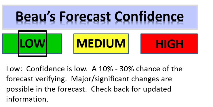
Sunday – Becoming cloudy with a chance of afternoon light snow. Highs in the 20’s. Northeast winds at 10 mph. My confidence in this part of the forecast verifying is low
Sunday night – A chance for light snow. Still a lot of uncertainty on placement of the best snow chances. Best chances could end up over our southern and southwest counties. Lows in the teens. Northeast winds at 10 mph. My confidence in this part of the forecast verifying is low
Monday – Cloudy. Any snow will come to an end – will be watching a second system coming out of the southern United States. Again, questions remain on the track of that system, as well. Cold. My confidence in this part of the forecast verifying is low
Current Temperatures Around The Local Area


An explanation of what is happening in the atmosphere over the coming days…
Well, for the last week I have been telling you that this weekend into next week would become active.
I will add some snow probability graphics at the top of the page later today. Watch for those. Those will be my accumulation forecast graphics.
A strong cold front arrives today. This front will usher in bitterly cold air by late today and tonight. Temperatures by Sunday morning will fall into the single digits.
The cold front will reach the Ohio River early this afternoon. Temperatures will quickly fall behind the cold front. Snow showers will accompany the front. There could be some light accumulation of snow over parts of the area. The best chance of that would be over southeast Illinois, southwest Indiana, and northwest Kentucky – further east in Kentucky, as well.
Snowfall totals today/this afternoon would be very light – a dusting up to an inch or so. Small chance for more than that over southwest Indiana and perhaps northwest Kentucky.
Gusty winds will mean very cold wind chills. Expect below zero wind chills on Saturday night and Sunday morning.
Again, morning low temperatures on Sunday will be in the single digits to lower teens.
High temperatures are Sunday may not get out of the teens and twenties. Very cold for this time of the year.
Sunday’s weather event…
Very low confidence on the Sunday part of the forecast.
A light snow event will move into our area on Sunday afternoon and Sunday night. Snow will develop over Missouri and Arkansas on Sunday morning. This snow will increase in aerial coverage on Sunday afternoon as it spreads into our area.
That is where the confidence ends. This system is going pretty far south. It may end up that the best snow chances will be over southeast Missouri down into northern Arkansas and west Tennessee. Perhaps far southern Illinois and western Kentucky. But, confidence is very low.
I am hoping that today’s data will bring more clarity to how Sunday afternoon and night will unfold. I will update the blog – top of the page with new information.
Snow ratios will be very high with this system. Expect 15:1 to 20:1 snow ratios. That means that 0.10″ of precipitation would be 1.5 to 2.0 inches of snow. If you had 0.20″ of precipitation then it would mean 3″-4″ of snow – and so on.
It does appear that liquid amounts should be in the 0.10-0.30″ range. That would mean a few inches of snow for areas that end up under the snow band. Again, monitor updates concerning placement.
Another system on Monday and Tuesday – this system has been shifting northward in the latest model data. The trend was south south south and now it is north. That tends to happen with models. The question is how FAR north will it trend. This will need to be closely monitored.
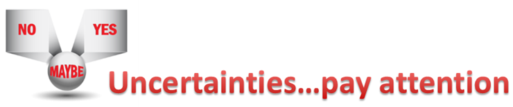
The uncertainties part of the e-journal spells out where I am not confident in the forecast. I always tell people to pay attention to the whole forecast and not just the part they want to hear.
Obviously the big concern is the snow event on Sunday. A lot of uncertainties surround this storm. The placement of the snow band is the biggest concern. How far south and west will the accumulating snow fall. I feel pretty good about parts of southeast Missouri down into northern Arkansas. Less confident about southern Illinois and western Kentucky.
The trend has been south and west with the Sunday afternoon and night event. If it tracks much further south and west then there won’t be much snow at all for some counties (maybe no snow for some).
The second uncertainty surrounds the MON/TUE storm. The trend has been north with that event. This will need to be closely monitored, as well.
Lots of uncertainties. But, that is how winter weather events go.

WANT TO HELP SUPPORT THIS BLOG AND COVER EXPENSES?
Did you know that the Weather Observatory is funded by people like you? I rely on ad’s on this blog and individual donations. PayPal also allows you to set up a monthly recurring donation. I have had several people give $5, $10, and $20 a month. A recurring donation helps keep the weather information flowing. If you enjoy this blog, the Twitter account, the Facebook interaction, the weather radars, and all of the other information then consider making a donation or setting up a recurring donation (if you don’t use PayPal then contact me through email about how you can mail a donation) beaudodson@usawx.com
Or mail a check to
Beau Dodson
3954 Mermet Road
Belknap, IL
62908
Thank you for your support!

Updated snow discussion and temperatures.

Strong cold front today will bring cold temperatures by afternoon. Afternoon temperatures will fall into the teens and 20’s. Snow showers today – maybe a dusting to an inch or so in some counties of southern Illinois and northwest Kentucky – not sure if that would happen further west/southwest. Small chances.
Winds will produce wind chill values well below zero tonight into Sunday morning.
Some snow is possible on Sunday afternoon and night. If snow does fall then it will stick since roads will be plenty cold.
Watching the Monday/Tuesday system. It has been shifting north, a bit.
Bitterly cold air will continue into the middle of next week.
Check out our newest sponsors $5 meal! The DQ Grill and Chill (located across from Noble Park in Paducah, Kentucky) is the newest WeatherTalk Blog sponsor! A local business helping to sponsor the weather information that you have come to love so much.
They have a Facebook Page and I encourage you to check it out. DQ Grill and Chill on Facebook


The wild card tells you where the uncertainties are in the forecast
Wild card in this forecast – the wild card centers around snow showers today. Will someone pick up a dusting of snow – maybe an inch or so? Possibly. The best chance of this would be over southeast Illinois and southwest Indiana – northwest Kentucky.
The second wild card falls squarely on Sunday’s snow event. Lot of uncertainty about where to place the best chance of snow and amounts.
Another wild card is the Monday/Tuesday system. It has been shifting northward. Much more of a shift north and we will have to think about precipitation into our southern counties. Monitor updates.

Can we expect severe thunderstorms over the next 24 to 48 hours? Remember that a severe thunderstorm is defined as a thunderstorm that produces 58 mph winds or higher, quarter size hail or larger, and/or a tornado.
Thunderstorm threat level is ZERO


We have regional radars and local city radars – if a radar does not seem to be updating then try another one. Occasional browsers need their cache cleared. You may also try restarting your browser. That usually fixes the problem. Occasionally we do have a radar go down. That is why I have duplicates. Thus, if one fails then try another one.
If you have any problems then please send me an email beaudodson@usawx.com
WEATHER RADAR PAGE – Click here —
We also have a new national interactive radar – you can view that radar by clicking here.
Local interactive city radars include St Louis, Mt Vernon, Evansville, Poplar Bluff, Cape Girardeau, Marion, Paducah, Hopkinsville, Memphis, Nashville, Dyersburg, and all of eastern Kentucky – these are interactive radars. Local city radars – click here
NOTE: Occasionally you will see ground clutter on the radar (these are false echoes). Normally they show up close to the radar sites – including Paducah.

Regional Radar – Click on radar to take you our full radar page.


Regional Radar

Will I need to take action?
Very cold wind chills tonight into Sunday morning. Expect wind chills to fall below zero. Actual air temperatures will be in the single digits to lower teens.
If snow falls on Sunday afternoon and night then it could cause hazardous driving conditions. Monitor updates as we move forward. I will post updates at the top of the page and on my weather Facebook page.

How much precipitation should we expect over the next few days?
No rain.
Light flurries or snow showers today with perhaps a dusting or so in spots.
Another chance for light snow on Sunday afternoon and night. Some accumulation possible. Likely light.
Watching the Monday and Tuesday system. If it trends further north then I might need to introduce precipitation chances for parts of our area. That would be snow…if anything falls.
We have a new sponsor! G&C Multi-Services out of Paducah, Kentucky. G & C Multi-Services is a service provider in Western Kentucky that provides industrial and commercial equipment fabrication, machine troubleshooting, repair and maintenance, and installation. They can custom fabricate steel, stainless, and aluminum products per customer specifications.
Visit their web-site here. Or click the ad below! They have a Facebook page and it can be viewed here.


Yes – finally some snow for you snow fans.
Some snow showers will develop today over the area – light snow showers and flurries. Gusty winds, as well. Single digit temperatures by Sunday morning. BRRR
Another chance of snow will develop on Sunday afternoon and night. We will likely see some accumulation of snow from the Sunday system. Questions remain on placement of accumulating snow. Any snow that falls will immediately stick. Ground temperatures will be very cold – so will roads. Snow will have no problem sticking.
Jim Rasor has a new blog. Check it out when you have time http://mylocalweather.net/forum/home

This section of the blog is speculative forecast information. Because it is past the range of what meteorologists can forecast accurately, it should be considered speculation. Anything past day 5 is considered a long range forecast.
Focus today is on the weekend snow system.
I am watching some additional precipitation chances later next week into the following week. It does look active…as I promised it would be.

Who do you trust for your weather information and who holds them accountable?
I have studied weather in our region since the late 1970’s. I have 37 years of experience in observing our regions weather patterns. My degree is in Broadcast Meteorology from Mississippi State University and an Associate of Science (AS). I am currently working on my Bachelor’s Degree in Geoscience. Just need to finish two Spanish classes!
I am a member of the American Meteorological Society. I am a NOAA Weather-Ready Nation Ambassador. And, I am the Meteorologist for McCracken County Emergency Management.
I own and operate the Southern Illinois Weather Observatory.
There is a lot of noise on the internet. A lot of weather maps are posted without explanation. Over time you should learn who to trust for your weather information.
My forecast philosophy is simple and straight forward.
- Communicate in simple terms
- To be as accurate as possible within a reasonable time frame before an event
- Interact with you on Twitter, Facebook, and the blog
- Minimize the “hype” that you might see on television or through other weather sources
- Push you towards utilizing wall-to-wall LOCAL TV coverage during severe weather events
I am a recipient of the Mark Trail Award, WPSD Six Who Make A Difference Award, Kentucky Colonel, and the Caesar J. Fiamma” Award from the American Red Cross. In 2009 I was presented with the Kentucky Office of Highway Safety Award. I was recognized by the Kentucky House of Representatives for my service to the State of Kentucky leading up to several winter storms and severe weather outbreaks.
If you click on the image below you can read the Kentucky House of Representatives Resolution.

I am also President of the Shadow Angel Foundation which serves portions of western Kentucky and southern Illinois.
![]()
Current WARNINGS (a warning means take action now). Click on your county to drill down to the latest warning information. Keep in mind that there can be a 2-3 minute delay in the updated warning information.
I strongly encourage you to use a NOAA Weather Radio or warning cell phone app for the most up to date warning information. Nothing is faster than a NOAA weather radio.


Color shaded counties are under some type of watch, warning, advisory, or special weather statement. Click your county to view the latest information.

Missouri Warnings

Illinois Warnings

Kentucky Warnings

Please visit your local National Weather Service Office by clicking here. The National Weather Service Office, for our region, is located in Paducah, Kentucky. They have a lot of maps and information on their site. Local people…local forecasters who care about our region.


Here is the official 6-10 day and 8-14 day temperature and precipitation outlook. Check the date stamp at the top of each image (so you understand the time frame).
The forecast maps below are issued by the Weather Prediction Center (NOAA).


The latest 8-14 day temperature and precipitation outlook. Note the dates are at the top of the image. These maps DO NOT tell you how high or low temperatures or precipitation will be. They simply give you the probability as to whether temperatures or precipitation will be above or below normal.


Many of my graphics are from www.weatherbell.com – a great resource for weather data, model data, and more


This blog was inspired by ABC 33/40’s Alabama Weather Blog – view their blog
Current tower cam view from the Weather Observatory- Click here for all cameras.

Southern Illinois Weather Observatory

The Weather Observatory

Southern Illinois Weather Observatory
WSIL TV 3 has a number of tower cameras. Click here for their tower camera page & Illinois Road Conditions

Marion, Illinois
WPSD TV 6 has a number of tower cameras. Click here for their tower camera page & Kentucky Road Conditions & Kentucky Highway and Interstate Cameras

Downtown Paducah, Kentucky
Benton, Kentucky Tower Camera – Click here for full view

Benton, Kentucky

I24 Paducah, Kentucky

I24 Mile Point 9 – Paducah, KY

I24 – Mile Point 3 Paducah, Kentucky

You can sign up for my AWARE email by clicking here I typically send out AWARE emails before severe weather, winter storms, or other active weather situations. I do not email watches or warnings. The emails are a basic “heads up” concerning incoming weather conditions.