
Click one of the links below to take you directly to that section
![]()
![]()
![]()
![]()
![]()
![]()
![]()
Do you have any suggestions or comments? Email me at beaudodson@usawx.com
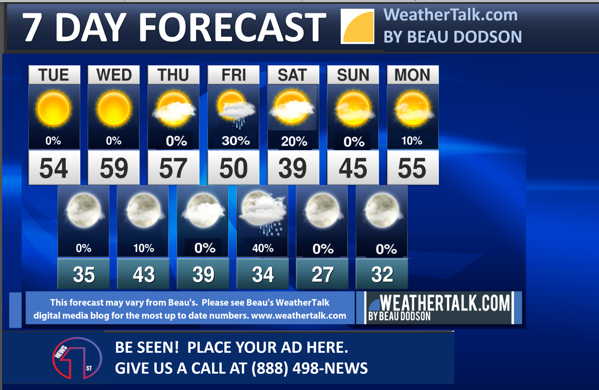
Seven-day forecast for southeast Missouri, southern Illinois, western Kentucky, and western Tennessee.
This is a BLEND for the region. Scroll down to see the region by region forecast.
THE FORECAST IS GOING TO VARY FROM LOCATION TO LOCATION. Scroll down to see the region by region forecast.

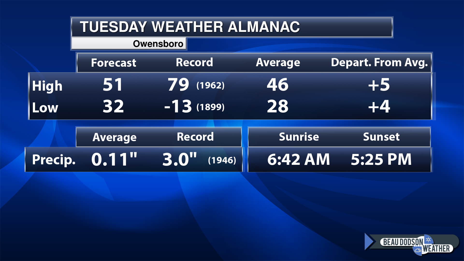
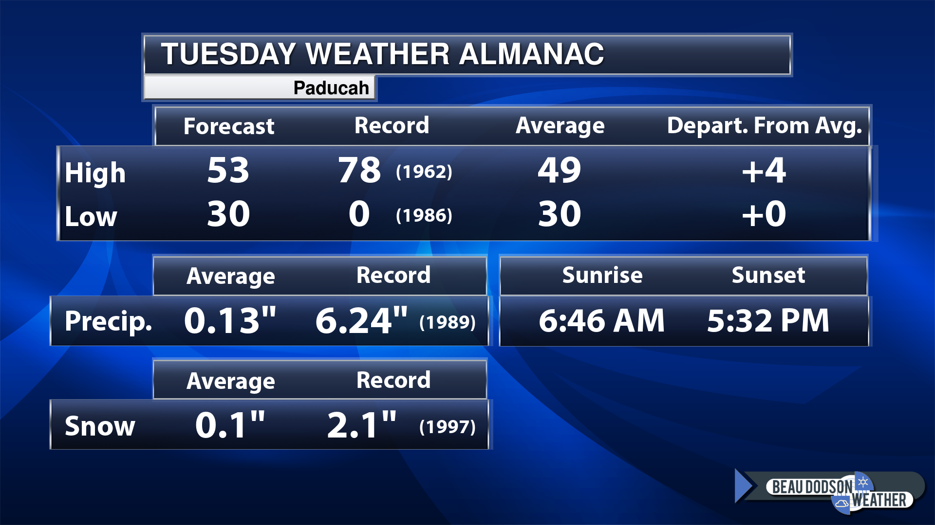
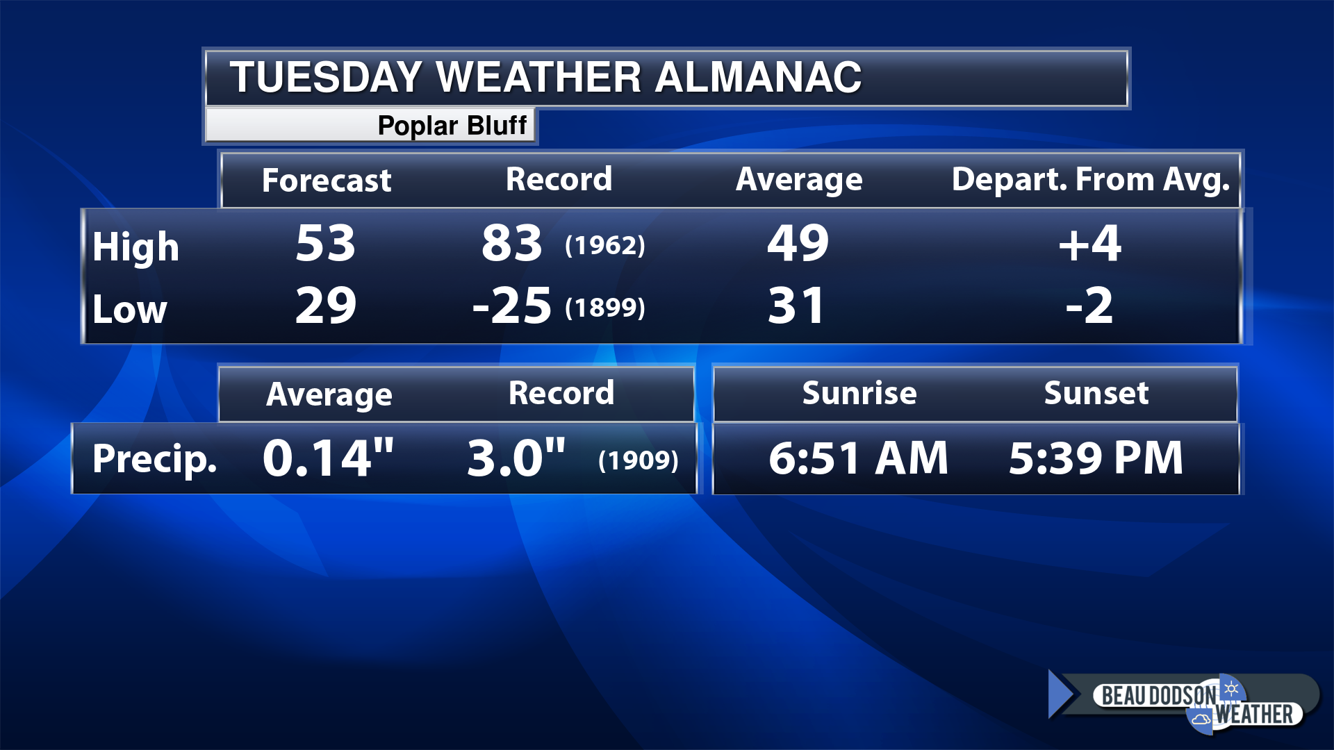
Today’s Local Almanacs (for a few select cities). Your location will be comparable.
Note, the low is this morning’s low and not tomorrows.
Today’s almanac numbers from a few select local cities.
The forecast temperature shows you today’s expected high and this morning’s low.
The graphic shows you the record high and record low for today. It shows you what year that occurred, as well.
It then shows you what today’s average temperature is.
Then, it shows you the departures (how may degrees above or below average temperatures will be ).
It shows you the average precipitation for today. Average comes from thirty years of rain totals.
It also shows you the record rainfall for the date and what year that occurred.
The sunrise and sunset are also shown.

If you have not subscribed to my YouTube Channel then click on this link and it will take you to my videos.
Click the button below and it will take you to the Beau Dodson YouTube Channel.

![]()
48-hour forecast


.

.
Tuesday to Tuesday
1. Is lightning in the forecast? NO.
2. Are severe thunderstorms in the forecast? NO.
3. Is flash flooding in the forecast? NO.
4. Will the heat index exceed 100 degrees? NO.
5. Will the wind chill dip below 10 degrees? NO.
6. Is measurable snow and/or sleet in the forecast? LOW CHANCE. I am watching another system Friday/Saturday.
7. Is freezing rain/ice in the forecast? LOW CHANCE. I will keep an eye on a cold front Friday night.
Freezing rain is rain that falls and instantly freezes on objects such as trees and power lines Freezing fog possible, as well.
.
Fire weather risk level.
Tuesday: 4. Low risk.
Tuesday night. 5. Moderate risk.
Wednesday through Wednesday night: 5. Moderate risk.
Fire Weather Discussion
Dry weather is expected for the middle of the week with temperatures warming to well above normal. A chance of showers returns to the forecast Friday afternoon through Friday night, with cooler weather projected for the weekend. Temperatures then return to above normal to start off next week, along with dry conditions.
A Haines Index of 6 means a high potential for an existing fire to become large or exhibit erratic fire behavior, 5 means medium potential, 4 means low potential, and anything less than 4 means very low potential.
.

.
Tuesday Forecast: Becoming mostly sunny.
What is the chance of precipitation?
Far northern southeast Missouri ~ 0%
Southeast Missouri ~ 0%
The Missouri Bootheel ~ 0%
I-64 Corridor of southern Illinois ~ 0%
Southern Illinois ~ 0%
Extreme southern Illinois (southern seven counties) ~ 0%
Far western Kentucky (Purchase area) ~ 0%
The Pennyrile area of western KY ~ 0%
Northwest Kentucky (near Indiana border) ~ 0%
Northwest Tennessee ~ 0%
Coverage of precipitation:
Timing of the precipitation:
Far northern southeast Missouri ~ 54° to 58°
Southeast Missouri ~ 52° to 54°
The Missouri Bootheel ~ 52° to 54°
I-64 Corridor of southern Illinois ~ 52° to 54°
Southern Illinois ~ 52° to 54°
Extreme southern Illinois (southern seven counties) ~ 52° to 54°
Far western Kentucky ~ 52° to 54°
The Pennyrile area of western KY ~52° to 54°
Northwest Kentucky (near Indiana border ~ 52° to 54°
Northwest Tennessee ~ 52° to 54°
Winds will be from this direction: West 7 to 14 mph
Wind chill or heat index (feels like) temperature forecast: 48° to 52°
What impacts are anticipated from the weather?
Should I cancel my outdoor plans?
UV Index: 4. Moderate.
Sunrise: 6:46 AM
Sunset: 5:32 PM .
.
Tuesday Night Forecast: Mostly clear.
What is the chance of precipitation?
Far northern southeast Missouri ~ 0%
Southeast Missouri ~ 0%
The Missouri Bootheel ~ 0%
I-64 Corridor of southern Illinois ~ 0%
Southern Illinois ~ 0%
Extreme southern Illinois (southern seven counties) ~ 0%
Far western Kentucky (Purchase area) ~ 0%
The Pennyrile area of western KY ~ 0%
Northwest Kentucky (near Indiana border) ~ 0%
Northwest Tennessee ~ 0%
Coverage of precipitation:
Timing of the precipitation:
Temperature range:
Far northern southeast Missouri 32° to 34°
Southeast Missouri ~ 32° to 34°
The Missouri Bootheel ~ 33° to 36°
I-64 Corridor of southern Illinois ~ 32° to 34°
Southern Illinois ~ 32° to 34°
Extreme southern Illinois (southern seven counties) ~ 32° to 35°
Far western Kentucky ~ 32° to 35°
The Pennyrile area of western KY ~ 32° to 35°
Northwest Kentucky (near Indiana border) ~ 32° to 35°
Northwest Tennessee ~ 32° to 35°
Winds will be from this direction: South southwest 5 to 10 mph
Wind chill or heat index (feels like) temperature forecast: 28° to 34°
What impacts are anticipated from the weather?
Should I cancel my outdoor plans?
Moonrise: 9:02 AM
Moonset: 10:15 PM
The phase of the moon: Waxing Crescent
.
Wednesday Forecast: Mostly sunny. Mild. Nice.
What is the chance of precipitation?
Far northern southeast Missouri ~ 0%
Southeast Missouri ~ 0%
The Missouri Bootheel ~ 0%
I-64 Corridor of southern Illinois ~ 0%
Southern Illinois ~ 0%
Extreme southern Illinois (southern seven counties) ~ 0%
Far western Kentucky (Purchase area) ~ 0%
The Pennyrile area of western KY ~ 0%
Northwest Kentucky (near Indiana border) ~ 0%
Northwest Tennessee ~ 0%
Coverage of precipitation:
Timing of the precipitation:
Far northern southeast Missouri ~ 58° to 60°
Southeast Missouri ~ 58° to 60°
The Missouri Bootheel ~ 58° to 62°
I-64 Corridor of southern Illinois ~ 58° to 60°
Southern Illinois ~ 58° to 62°
Extreme southern Illinois (southern seven counties) ~ 58° to 62°
Far western Kentucky ~ 58° to 62°
The Pennyrile area of western KY ~ 58° to 62°
Northwest Kentucky (near Indiana border 58° to 62°
Northwest Tennessee ~ 58° to 62°
Winds will be from this direction: Southwest 8 to 16 mph
Wind chill or heat index (feels like) temperature forecast: 58° to 60°
What impacts are anticipated from the weather?
Should I cancel my outdoor plans?
UV Index: 4. Moderate.
Sunrise: 6:45 AM
Sunset: 5:33 PM .
.
Wednesday Night Forecast: Increasing clouds.
What is the chance of precipitation?
Far northern southeast Missouri ~ 10%
Southeast Missouri ~ 10%
The Missouri Bootheel ~ 0%
I-64 Corridor of southern Illinois ~ 10%
Southern Illinois ~ 0%
Extreme southern Illinois (southern seven counties) ~ 0%
Far western Kentucky (Purchase area) ~ 0%
The Pennyrile area of western KY ~ 0%
Northwest Kentucky (near Indiana border) ~ 0%
Northwest Tennessee ~ 0%
Coverage of precipitation:
Timing of the precipitation:
Temperature range:
Far northern southeast Missouri 38° to 42°
Southeast Missouri ~ 38° to 42°
The Missouri Bootheel ~ 40° to 44°
I-64 Corridor of southern Illinois ~ 38° to 42°
Southern Illinois ~ 40° to 42°
Extreme southern Illinois (southern seven counties) ~ 40° to 42°
Far western Kentucky ~ 40° to 42°
The Pennyrile area of western KY ~ 38° to 42°
Northwest Kentucky (near Indiana border) ~ 40° to 42°
Northwest Tennessee ~ 40° to 42°
Winds will be from this direction: Southwest 10 to 20 mph. Gusty.
Wind chill or heat index (feels like) temperature forecast: 36° to 42°
What impacts are anticipated from the weather? Wet roadways.
Should I cancel my outdoor plans?
Moonrise: 9:30 AM
Moonset: 11:27 PM
The phase of the moon: Waxing Crescent
.
Thursday Forecast: Partly sunny. Mild.
What is the chance of precipitation?
Far northern southeast Missouri ~ 0%
Southeast Missouri ~ 0%
The Missouri Bootheel ~ 0%
I-64 Corridor of southern Illinois ~ 0%
Southern Illinois ~ 0%
Extreme southern Illinois (southern seven counties) ~ 0%
Far western Kentucky (Purchase area) ~ 0%
The Pennyrile area of western KY ~ 0%
Northwest Kentucky (near Indiana border) ~ 0%
Northwest Tennessee ~ 0%
Coverage of precipitation:
Timing of the precipitation:
Far northern southeast Missouri ~ 56° to 60°
Southeast Missouri ~ 58° to 62°
The Missouri Bootheel ~ 58° to 62°
I-64 Corridor of southern Illinois ~ 58° to 60°
Southern Illinois ~ 60° to 62°
Extreme southern Illinois (southern seven counties) ~ 60° to 62°
Far western Kentucky ~ 60° to 62°
The Pennyrile area of western KY ~ 60° to 64°
Northwest Kentucky (near Indiana border 58° to 62°
Northwest Tennessee ~ 60° to 64°
Winds will be from this direction: Becoming west northwest 10 to 20 mph. Gusty.
Wind chill or heat index (feels like) temperature forecast: 58° to 64°
What impacts are anticipated from the weather?
Should I cancel my outdoor plans?
UV Index: 4. Moderate.
Sunrise: 6:45 AM
Sunset: 5:35 PM .
.
Thursday Night Forecast: Intervals of clouds.
What is the chance of precipitation?
Far northern southeast Missouri ~ 0%
Southeast Missouri ~ 0%
The Missouri Bootheel ~ 0%
I-64 Corridor of southern Illinois ~ 0%
Southern Illinois ~ 0%
Extreme southern Illinois (southern seven counties) ~ 0%
Far western Kentucky (Purchase area) ~ 0%
The Pennyrile area of western KY ~ 0%
Northwest Kentucky (near Indiana border) ~ 0%
Northwest Tennessee ~ 0%
Coverage of precipitation:
Timing of the precipitation:
Temperature range:
Far northern southeast Missouri 32° to 34°
Southeast Missouri ~ 32° to 34°
The Missouri Bootheel ~ 32° to 35°
I-64 Corridor of southern Illinois ~ 32° to 34°
Southern Illinois ~ 32° to 34°
Extreme southern Illinois (southern seven counties) ~ 32° to 35°
Far western Kentucky ~ 32° to 35°
The Pennyrile area of western KY ~ 32° to 35°
Northwest Kentucky (near Indiana border) ~ 32° to 35°
Northwest Tennessee ~ 33° to 36°
Winds will be from this direction: Northeast 7 to 14 mph
Wind chill or heat index (feels like) temperature forecast: 28° to 34°
What impacts are anticipated from the weather?
Should I cancel my outdoor plans?
Moonrise: 10:01 AM
Moonset:
The phase of the moon: Waxing Crescent
.
Click here if you would like to return to the top of the page.

-
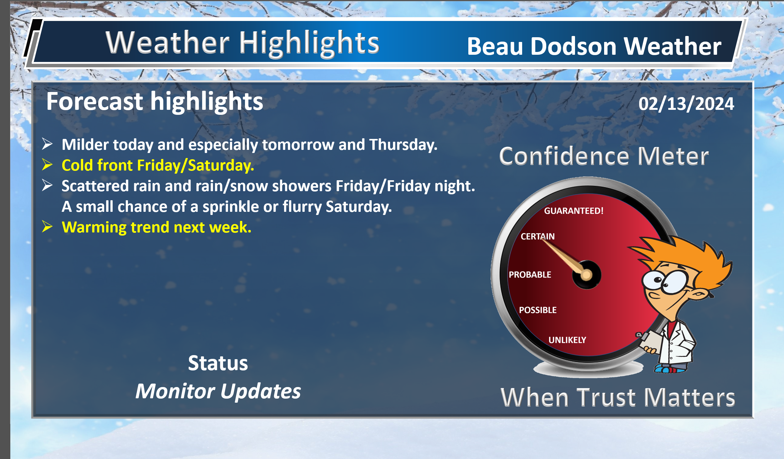
- Milder the next few days. Especially tomorrow and Thursday.
- Cold front Friday/Saturday.
Weather advice:
Make sure you have three to five ways of receiving your severe weather information.
Forecast Discussion
Well, I was highly skeptical of the snow event yesterday and I hope my products conveyed that message.
There was no winning that one. Conditions were favorable for heavy wet snow to develop. That did happen in western TN and part of western KY, but the ground was just too warm to cause much in the way of accumulation.
Some of the snowflakes that I saw were three and four inches in size. Incredibly large.
Warm ground, warm roads, warm air temperatures all helped prevent accumulation. I wasn’t happy with the forecast, but sometimes that is the way it goes.
I will always let you know when I am skeptical or have low confidence in the forecast outcome.
Let’s move on from that event!
We have plenty of sunshine today. A warming trend today and tomorrow, then turning colder Thursday night into the weekend.
Temperatures will then moderate again next week.
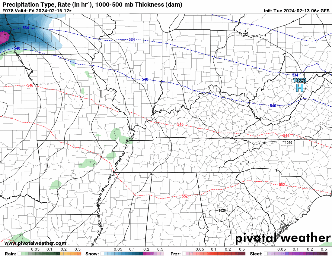
We will have a strong cold front push through the region Friday and Friday night. This will bring some showers and perhaps some rain/snow showers. Colder air.
Rain totals will be on the light side.
We will need to monitor snow shower chances Friday and Friday night.
The GFS model is mainly rain
The EC shows some snow
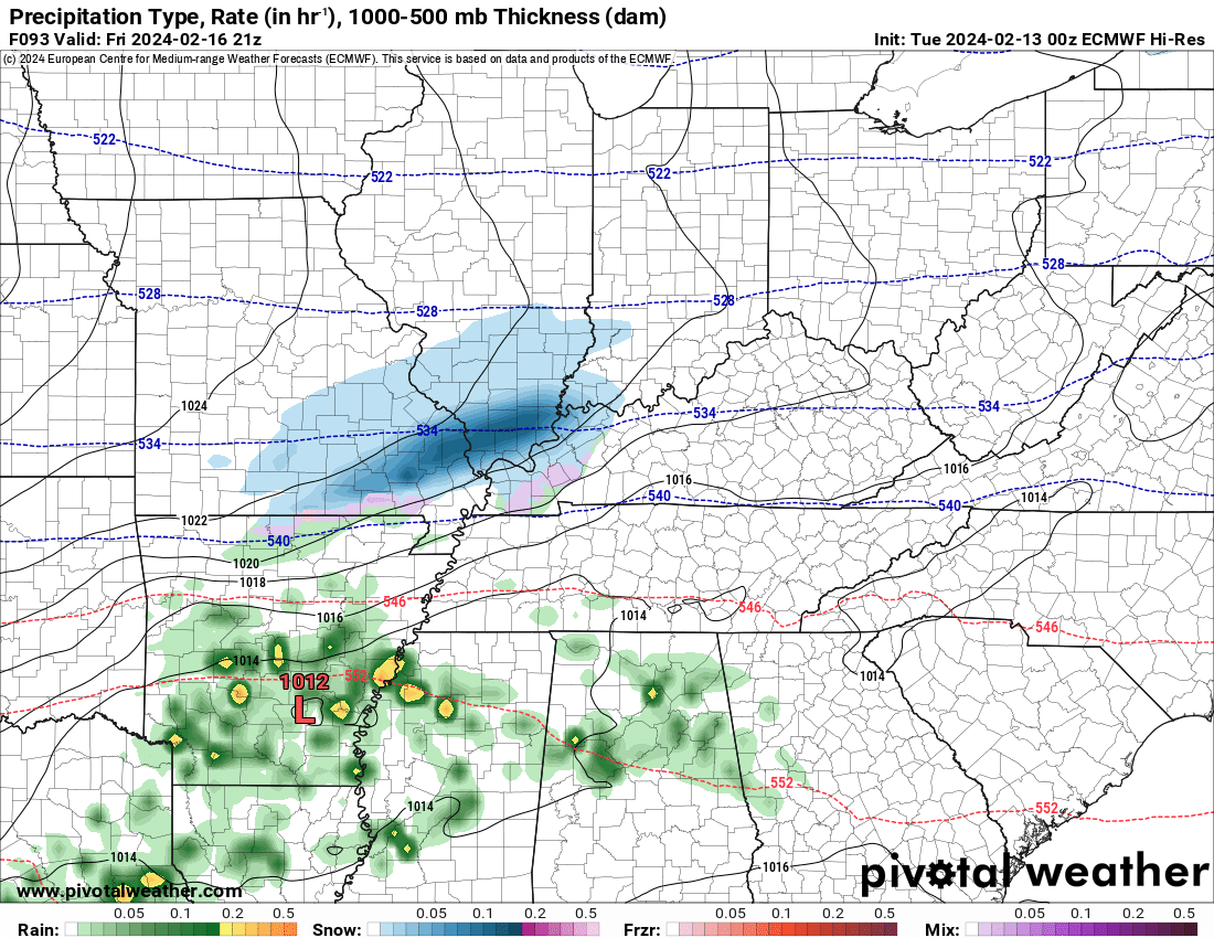
The Canadian model shows some snow, as well.
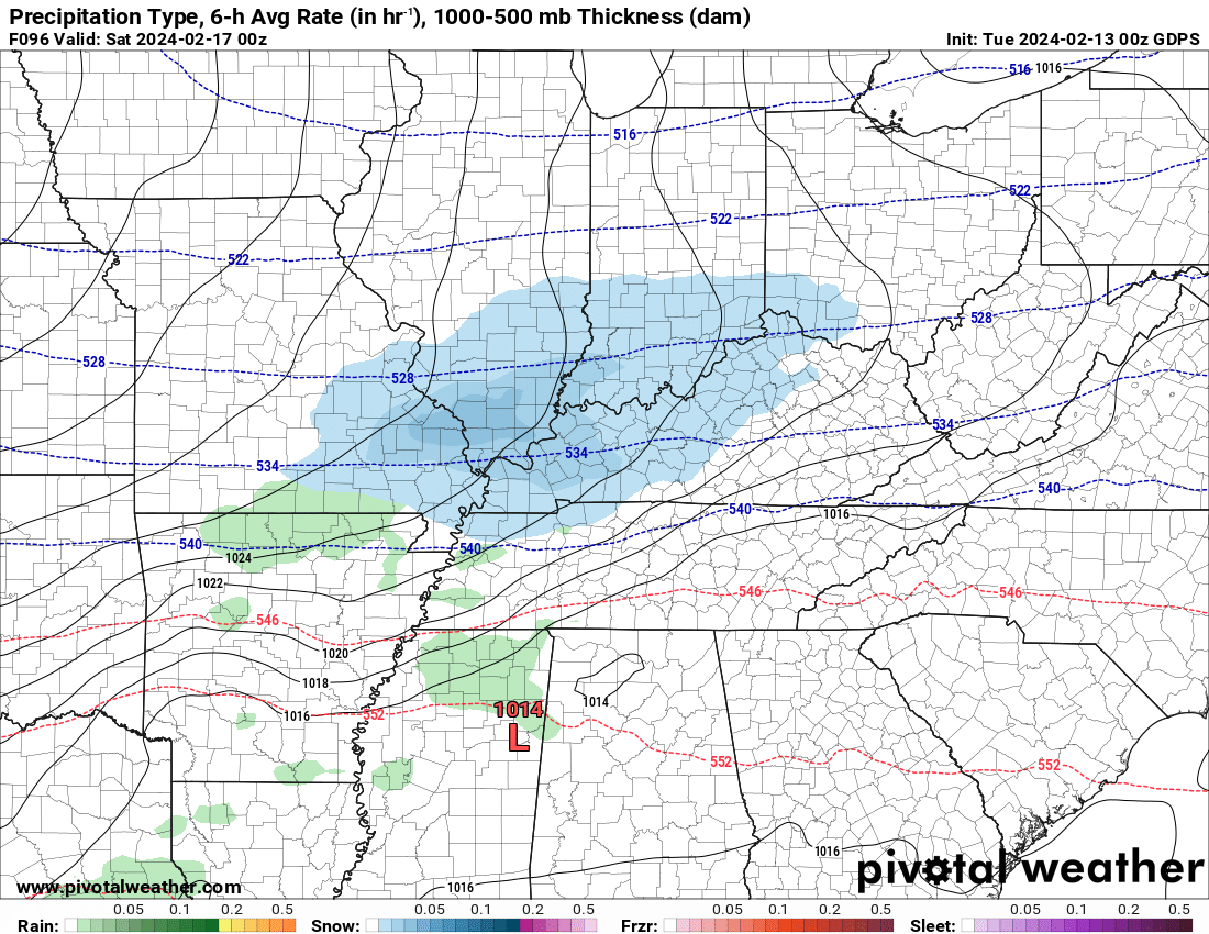
Gusty winds will also accompany the front. As a matter of fact, we will likely have gusty winds Wednesday PM into the weekend.
There are several cool/cold shots in the long range forecast, but I still can’t find anything extreme. I can’t find any true blue arctic outbreaks of air. I do see typical bursts of transient cold temperatures.
Is winter over? Well, we are certainly running out of time for sustained cold and snow. Once we move into the middle of March, we tend to see our snow chances greatly diminished.
I don’t have any severe weather in the current forecast. As we move deeper into February and March, we typically begin to see an uptake in severe weather chances. Make sure you and your family have multiple ways of receiving severe weather information.
![]()
.
Click here if you would like to return to the top of the page.
This outlook covers southeast Missouri, southern Illinois, western Kentucky, and far northwest Tennessee.

.
Today’s Storm Prediction Center’s Severe Weather Outlook
Light green is where thunderstorms may occur but should be below severe levels.
Dark green is a level one risk. Yellow is a level two risk. Orange is a level three (enhanced) risk. Red is a level four (moderate) risk. Pink is a level five (high) risk.
One is the lowest risk. Five is the highest risk.
A severe storm is one that produces 58 mph wind or higher, quarter size hail, and/or a tornado.
Explanation of tables. Click here.

.
Tornado Probability Outlook

.
Large Hail Probability Outlook

.
High wind Probability Outlook

.
Tomorrow’s severe weather outlook.

.
Day Three Severe Weather Outlook

.

.
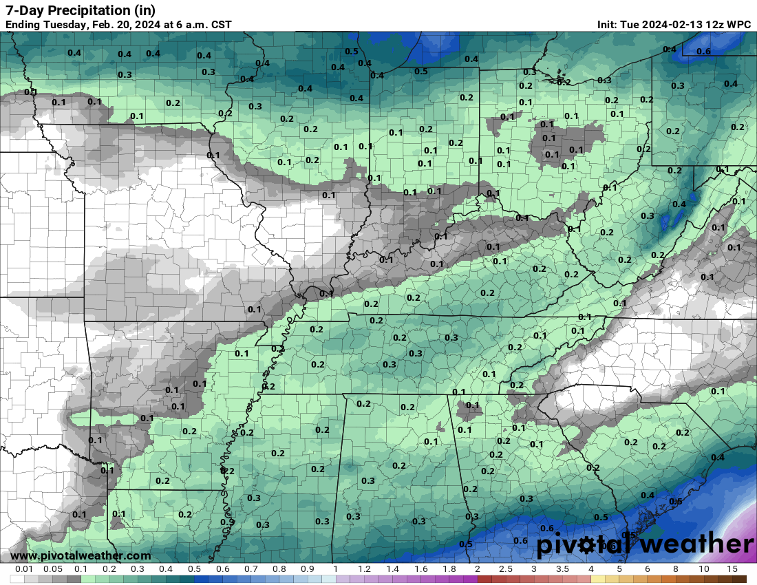
The images below are from NOAA’s Weather Prediction Center.
24-hour precipitation outlook..
 .
.
.
48-hour precipitation outlook.
. .
.
![]()
_______________________________________
.

Click here if you would like to return to the top of the page.
Again, as a reminder, these are models. They are never 100% accurate. Take the general idea from them.
What should I take from these?
- The general idea and not specifics. Models usually do well with the generalities.
- The time-stamp is located in the upper left corner.
.
What am I looking at?
You are looking at computer model data. Meteorologists use many different models to forecast the weather.
Occasionally, these maps are in Zulu time. 12z=7 AM. 18z=1 PM. 00z=7 PM. 06z=1 AM
Green represents light rain. Dark green represents moderate rain. Yellow and orange represent heavier rain.
.
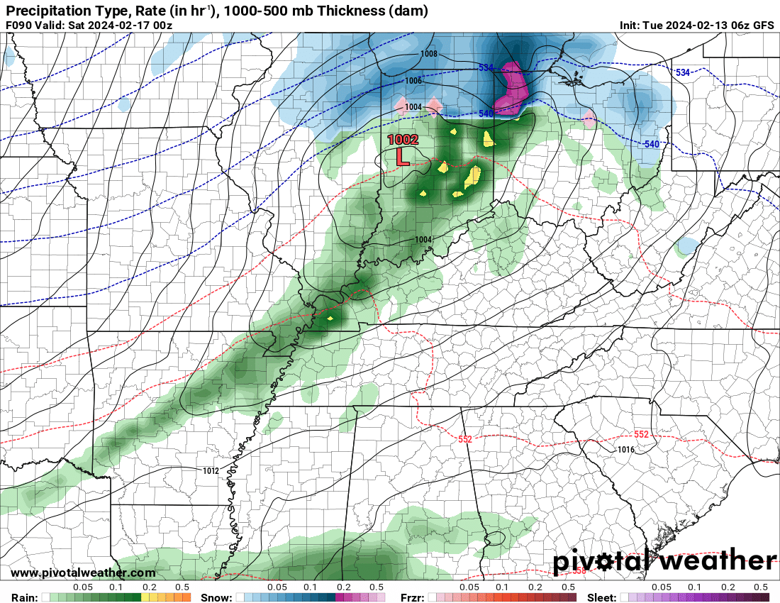
This animation is the HRRR Model.
Occasionally, these maps are in Zulu time. 12z=6 AM. 18z=12 PM. 00z=6 PM. 06z=12 AM
Double click images to enlarge them. Blue is snow. Pink is a wintry mix. Green is rain.
.
This animation is the NAM 3K Model.
Occasionally, these maps are in Zulu time. 12z=6 AM. 18z=12 PM. 00z=6 PM. 06z=12 AM
Double click images to enlarge them.
.
This animation is the GFS Model.
Green is rain. Yellow and orange are heavier rain. Pink is a wintry mix. Blue is snow. Dark blue is heavier snow.
Occasionally, these maps are in Zulu time. 12z=6 AM. 18z=12 PM. 00z=6 PM. 06z=12 AM
Double click images to enlarge them.
.
This animation is the EC Model.
Green is rain. Yellow and orange are heavier rain. Pink is a wintry mix. Blue is snow. Dark blue is heavier snow.
Occasionally, these maps are in Zulu time. 12z=6 AM. 18z=12 PM. 00z=6 PM. 06z=12 AM
Double click images to enlarge them.
..![]()

.
Click here if you would like to return to the top of the page.
.Average high temperatures for this time of the year are around 46 degrees.
Average low temperatures for this time of the year are around 28 degrees.
Average precipitation during this time period ranges from 0.50″ to 1.00″
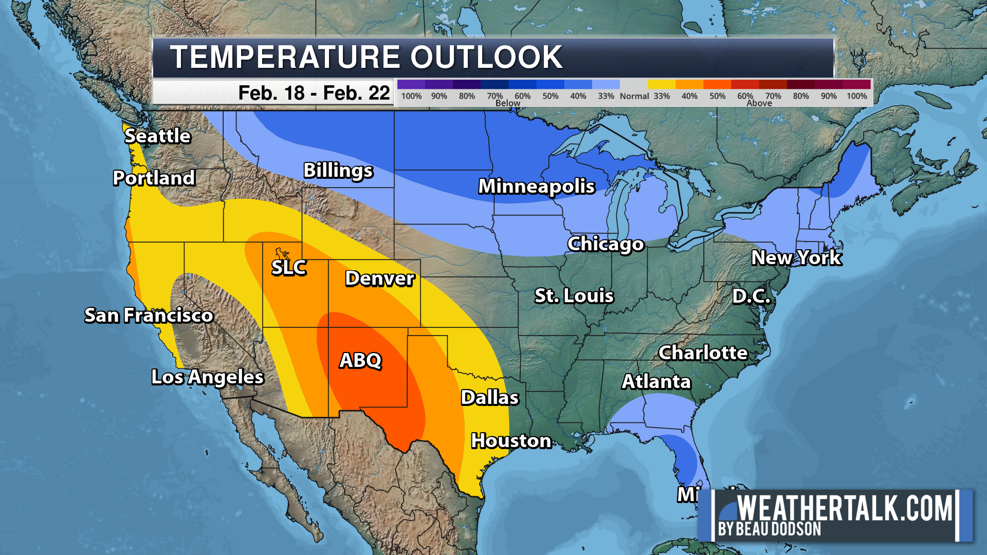
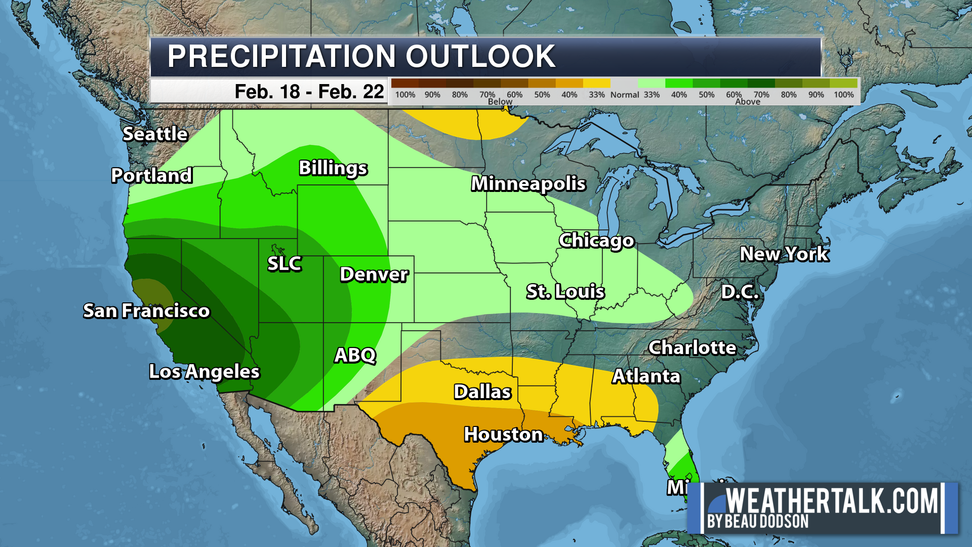
Six to Ten Day Outlook.
Blue is below average. Red is above average. The no color zone represents equal chances.
Average highs for this time of the year are in the lower 60s. Average lows for this time of the year are in the lower 40s.
Green is above average precipitation. Yellow and brown favors below average precipitation. Average precipitation for this time of the year is around one inch per week.
.

Average low temperatures for this time of the year are around 29 degrees.
Average precipitation during this time period ranges from 0.50″ to 1.00″
.
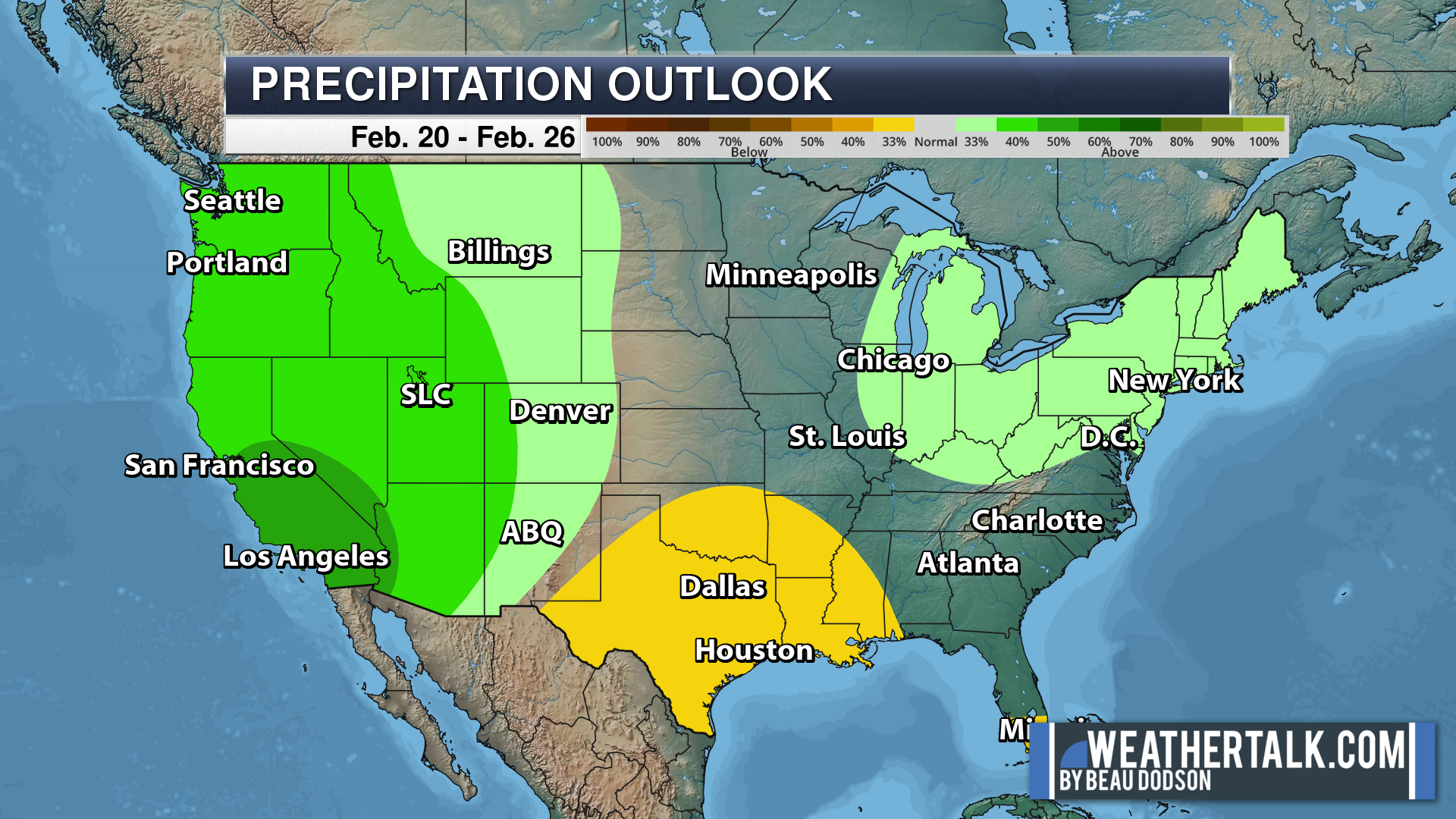
Eight to Fourteen Day Outlook.
Blue is below average. Red is above average. The no color zone represents equal chances.
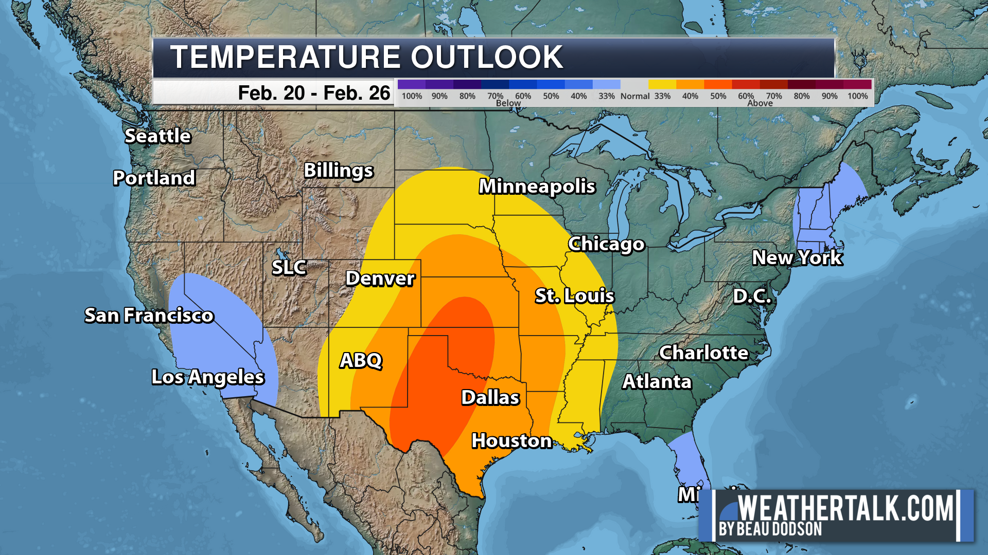
Green is above average precipitation. Yellow and brown favors below average precipitation. Average precipitation for this time of the year is around one inch per week.
.
![]()
The app is for subscribers. Subscribe at www.weathertalk.com/welcome then go to your app store and search for WeatherTalk
Subscribers, PLEASE USE THE APP. ATT and Verizon are not reliable during severe weather. They are delaying text messages.
The app is under WeatherTalk in the app store.

Apple users click here

Android users click here
.

Radars and Lightning Data
Interactive-city-view radars. Clickable watches and warnings.
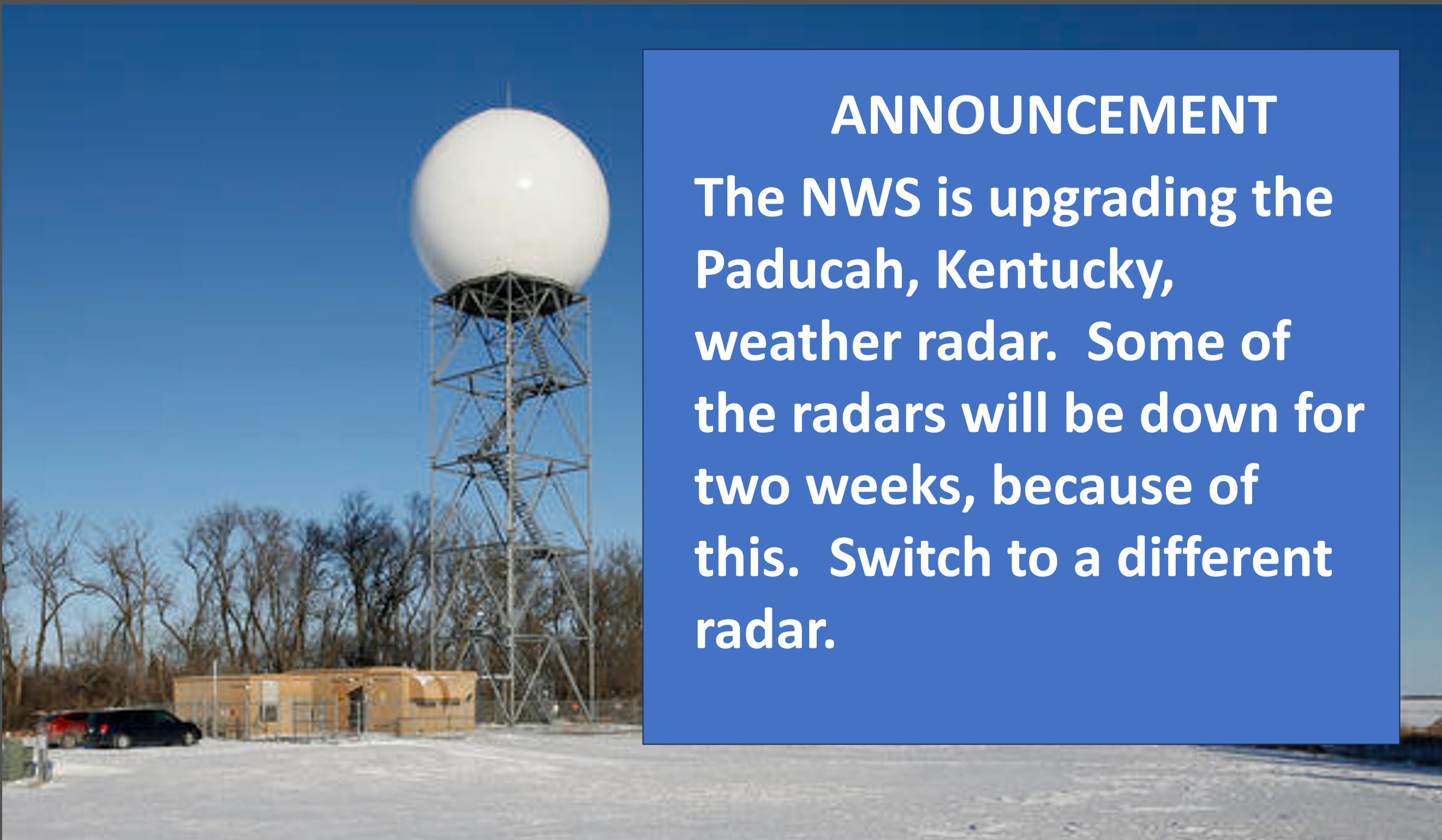
https://wtalk.co/B3XHASFZ
If the radar is not updating then try another one. If a radar does not appear to be refreshing then hit Ctrl F5. You may also try restarting your browser.
Backup radar site in case the above one is not working.
https://weathertalk.com/morani
Regional Radar
https://imagery.weathertalk.com/prx/RadarLoop.mp4
** NEW ** Zoom radar with chaser tracking abilities!
ZoomRadar
Lightning Data (zoom in and out of your local area)
https://wtalk.co/WJ3SN5UZ
Not working? Email me at beaudodson@usawx.com
National map of weather watches and warnings. Click here.
Storm Prediction Center. Click here.
Weather Prediction Center. Click here.
.

Live lightning data: Click here.
Real time lightning data (another one) https://map.blitzortung.org/#5.02/37.95/-86.99
Our new Zoom radar with storm chases
.
.

Interactive GOES R satellite. Track clouds. Click here.
GOES 16 slider tool. Click here.
College of DuPage satellites. Click here
.

Here are the latest local river stage forecast numbers Click Here.
Here are the latest lake stage forecast numbers for Kentucky Lake and Lake Barkley Click Here.
.
.
Find Beau on Facebook! Click the banner.


 .
.