We have some great sponsors for the Weather Talk Blog. Please let our sponsors know that you appreciate their support for the Weather Talk Blog.
Milner and Orr Funeral Home and Cremation Services located in Paducah, Kentucky and three other western Kentucky towns – at Milner and Orr they believe in families helping families. You can find Milner and Orr on Facebook, as well.
![]()
.

For all of your families eye care needs. Visit their web-site here. Or, you can also visit their Facebook page.
.

Best at Enabling Body Shop Profitability since 1996. Located In Paducah Kentucky and Evansville Indiana; serving all customers in between. They provide Customer Service, along with all the tools necessary for body shops to remain educated and competitive. Click the logo above for their main web-site. You can find McClintock Preferred Finishes on Facebook, as well
.

Duck/goose decoys? Game calls? Optics? We have you covered! Click the logo above or visit Final Flight on Facebook, as well.
.
I have launched the new weather texting service! I could use your help. Be sure and sign up and fully support all of the weather data you see each day.
This is a monthly subscription service. Supporting this helps support everything else. The cost is $3 a month for one phone, $5 a month for three phones, and $10 a month for seven phones.
For more information visit BeauDodsonWeather.com
Or directly sign up at Weathertalk.com


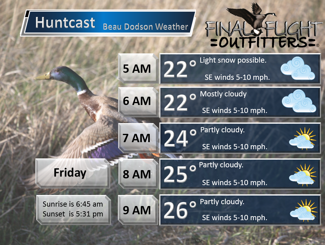
This forecast update covers far southern Illinois, far southeast Missouri, and far western Kentucky. See the coverage map on the right side of the blog.
Remember that weather evolves. Check back frequently for updates, especially during active weather.

Winter Weather Radars
WEATHER RADAR PAGE – Click here —
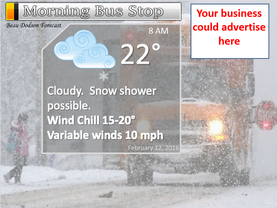
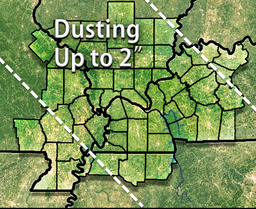
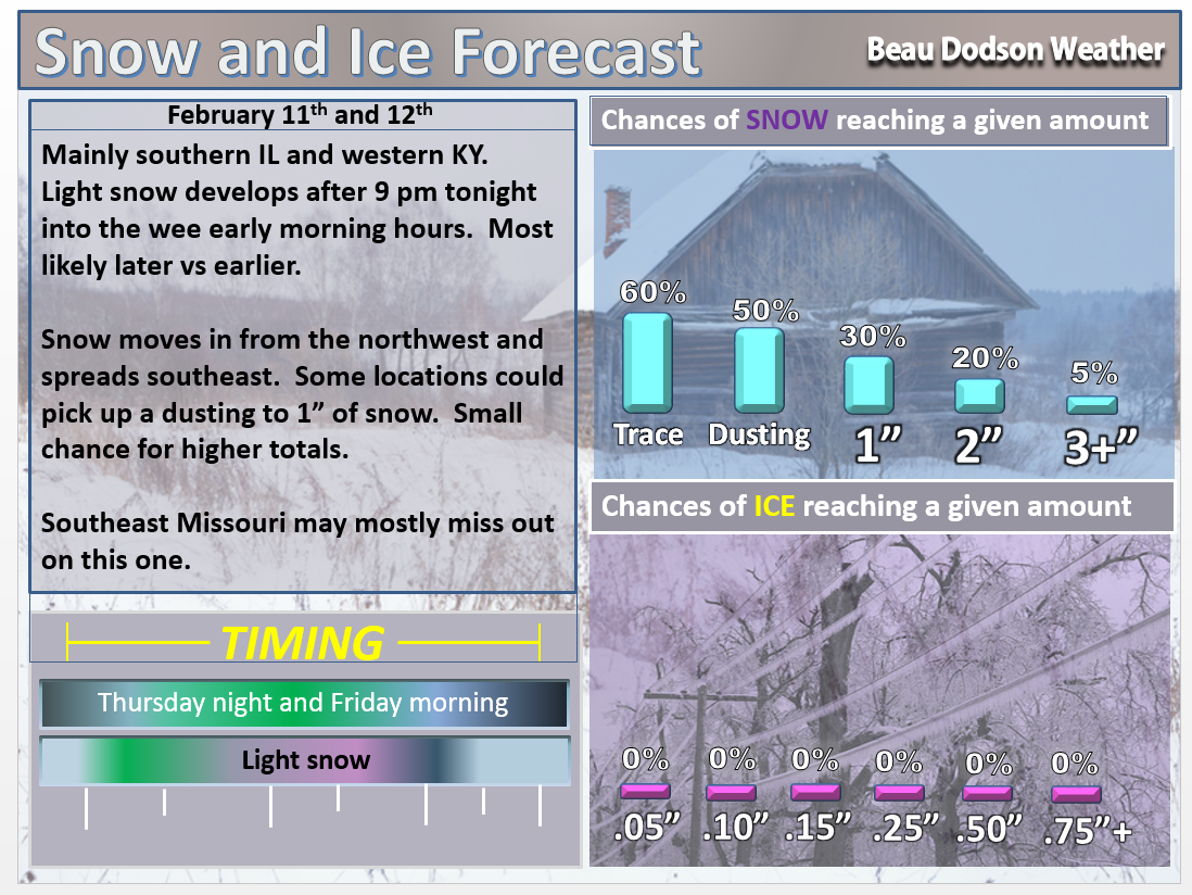
Thursday Night – Light snow developing late. Especially over southern Illinois and then spreading southeast into western Kentucky. A dusting to an inch or so possible. Smaller chances for western parts of southeast Missouri and northwest Tennessee. See maps further down in the blog.
Temperatures: Lows from 18-24 degrees
Winds: Northeast winds at 5-10 mph
What is the chance for precipitation? 60%
Coverage of precipitation? Scattered
My confidence in this part of the forecast verifying is High
Should I be concerned about snow or ice? Yes, some light snow possible.
Should I cancel my outdoor plans? No, but there could be slick spots develop late tonight.
Is severe weather expected? No
What impact is expected? Cold. Could still be some slick spots.
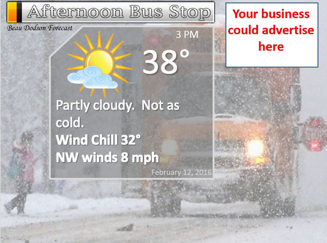
Friday – Morning snow ending. Partly to mostly cloudy. Not quite as cold.
Temperatures: Highs will range from 36 to 42 degrees. This should help any remaining slick spots on area roads.
Winds: Variable winds becoming west/southwest winds 5-10 mph.
What is the chance for precipitation? 60% before 9 am. 30% between 9 am and 12 pm
Coverage of precipitation? Perhaps spotty
My confidence in this part of the forecast verifying is Medium
Should I be concerned about snow or ice? Some snow showers early in the day will be possible. Mainly before sunrise. But, far southeast counties could still see snow showers into the morning hours.
Should I cancel my outdoor plans? No, but check travel conditions early in the morning.
Is severe weather expected? No
What impact is expected? Maybe some flurries or snow showers. Slick roads in the morning will be possible where snow falls overnight.
Friday Night – Clearing. Breezy at times. Colder.
Temperatures: Lows from 10-16 degrees. Locally colder.
Winds: North and northwest winds at 6-12 mph. Gusts to 15 mph.
What is the chance for precipitation? 0%
Coverage of precipitation? None
My confidence in this part of the forecast verifying is High
Should I be concerned about snow or ice? No
Should I cancel my outdoor plans? No, but it will be cold.
Is severe weather expected? No
What impact is expected? Cold. Could still be some slick spots. Low wind chills into the single digits.
Saturday – Mostly sunny. Cold. Perhaps some high clouds late in the day.
Temperatures: Highs will range from 18 to 28 degrees.
Winds: North winds at 6-12 mph.
What is the chance for precipitation? 0%
Coverage of precipitation? None
My confidence in this part of the forecast verifying is High
Should I be concerned about snow or ice? No
Should I cancel my outdoor plans? No, but it will be cold. Low wind chills.
Is severe weather expected? No
What impact is expected? Wind chills in the single digits to lower teens.
Saturday Night – Becoming cloudy. A slight chance for snow after 12 am over our western and northern counties of southeast Missouri and southern Illinois. Some questions remain on the timing.
Temperatures: Lows from 14 to 18 degrees
Winds: Northeast and east winds at 5-10 mph
What is the chance for precipitation? 40% after 12 am on Sunday morning. Mainly over southeast Missouri and southern Illinois.
Coverage of precipitation? Scattered
My confidence in this part of the forecast verifying is Medium
Should I be concerned about snow or ice? Very late at night we might see precipitation develop over southeast Missouri and southern Illinois.
Should I cancel my outdoor plans? No, but it will be cold.
Is severe weather expected? No
What impact is expected? Cold temperatures. Wind chills from 8-14 degrees. Some wintry precipitation possible late at night over southeast Missouri and southern Illinois.
Sunday – Cloudy. Snow developing. Snow may mix with sleet at times. Snow and sleet may accumulate 1″ to 3″. Roads are likely to become slick and hazardous.
Temperatures: Highs will range from 26-32 degrees.
Winds: South and southeast winds at 4-8 mph with gusts to 12 mph.
What is the chance for precipitation? 80%
Coverage of precipitation? Widespread
My confidence in this part of the forecast verifying is High
Should I be concerned about snow or ice? Wintry mix in the region
Should I cancel my outdoor plans? Roads may become snow and ice covered during the day on Sunday.
Is severe weather expected? No
What impact is expected? Roads will become snow and ice covered on Sunday into Sunday night.
Sunday Night – Snow likely. Cold.
Temperatures: Lows from 24-28 degrees
Winds: South winds at 5-10 mph
What is the chance for precipitation? 60%
Coverage of precipitation? Scattered to perhaps widespread
My confidence in this part of the forecast verifying is Medium
Should I be concerned about snow or ice? Some snow possible
Should I cancel my outdoor plans? Might want to have alternative plans
Is severe weather expected? No
What impact is expected? Slick roads possible.
Monday – Cloudy. Low confidence on Monday’s forecast. A chance for a wintry mix over western Kentucky and northwest Tennessee. Perhaps changing to rain. Some question on how Monday unfolds. Lot of data misses us to the south.
Temperatures: Rising temperatures into the 30s.
Winds: South winds at 6-12 mph.
What is the chance for precipitation? 40%
Coverage of precipitation? Scattered to perhaps widespread (depending on storm track)
My confidence in this part of the forecast verifying is Low
Should I be concerned about snow or ice? We may have a wintry mix in the region
Should I cancel my outdoor plans? No, but monitor weather updates.
Is severe weather expected? No
What impact is expected? Slick roadways will be possible on at least Monday morning.

Don’t forget to check out the Southern Illinois Weather Observatory web-site for weather maps, tower cams, scanner feeds, radars, and much more! Click here

An explanation of what is happening in the atmosphere over the coming days…
Highlights
1. Light snow possible Thursday night and Friday morning. Dusting to an inch or so over PARTS of the area.
2. Much colder Friday night into Sunday morning.
3. Winter storm possible on Sunday
4. More precipitation possible late Sunday night and Monday
5. Track of the Monday system is highly questionable
Don’t forget to sign up for the texting service. And, if you don’t want to receive text messages then remember the proceeds also cover the cost of this blog, the AWARE email (which is $100 a month to send out), the websites, the radars, and most importantly all of my time. You can sign up by visiting www.weathertalk.com
Winter Weather Radars
WEATHER RADAR PAGE – Click here –
We have a LOT to cover. Let’s get to it.
Tonight a weak system dives down from the northwest. I believe this is the third one this week.
Light snow will develop over Iowa and eastern Missouri later this evening and spread southeast.
This is a weak system and it does not have a lot of moisture to work with. Generally speaking, a dusting to perhaps an inch or so of snow will be possible with this event.
I have marked the most likely area to receive snow.
There is a 60% chance of this forecast verifying. I shifted it a little more southwest.
Here are the probabilities for snowfall totals on Thursday night and Friday morning. Again, mostly over southern Illinois, southwest Indiana, and western Kentucky.
Here is what the NAM model guidance from weatherbell.com is forecasting. The grey area represents a dusting to maybe 1-2″ of snow. Late tonight and on Friday morning (early – before 8 am). Blue would be 2-3″.
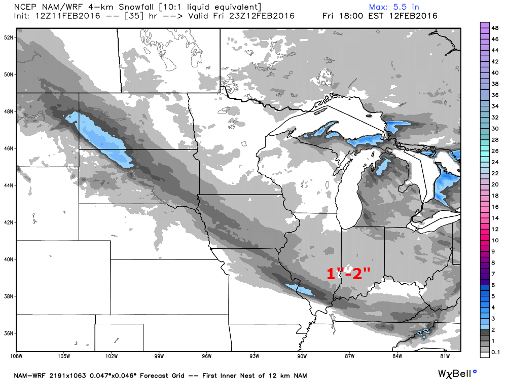
Future-cast radar from the NAM. This is what radar MIGHT look like tonight. This is guidance and not gospel. Models don’t always do well at showing exactly what will happen.
Ignore the green. This won’t be rain. The blue is snow.
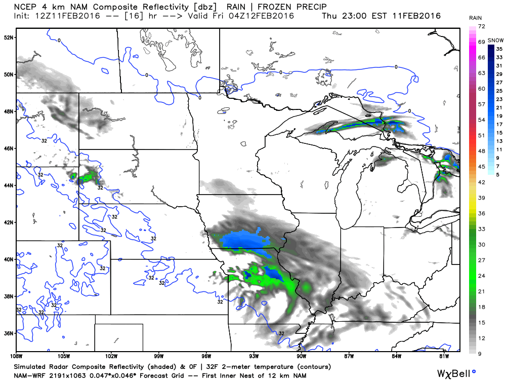
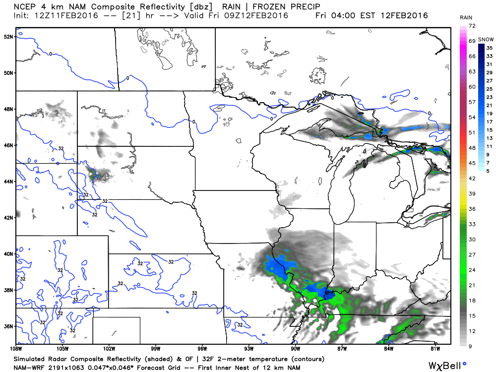
This is the 3 am image. You can see some snow over our local area. Fairly light.
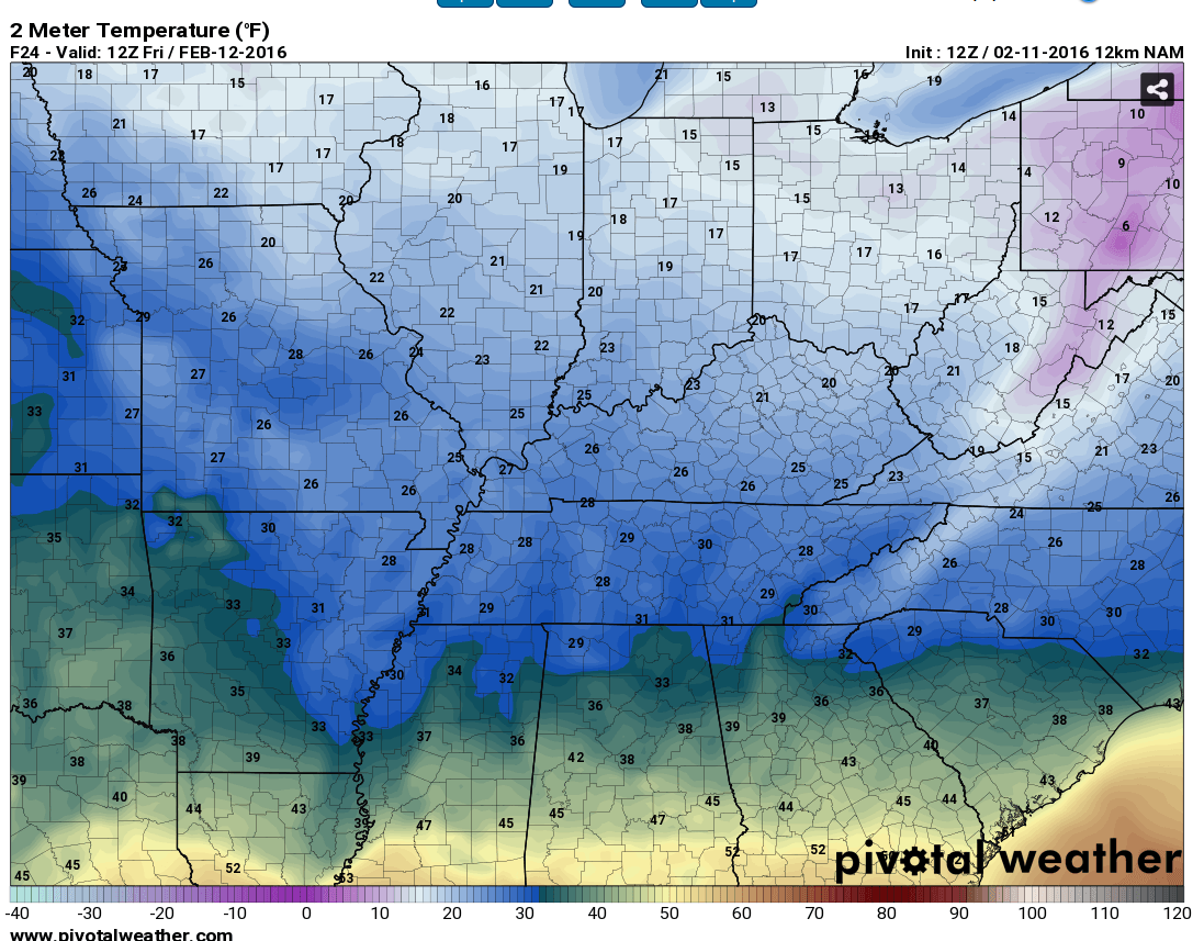
Check out the next blast of cold air.
An arctic blast of cold air will arrive Friday night and stick around into Sunday morning. Frigid temperatures on Saturday morning. Sunday morning, as well.
Here are the low temperature forecast numbers for Friday morning. Not too bad! Well, not too bad when compared to Saturday morning.
Here are the Saturday morning low temperature numbers. BRRRRR
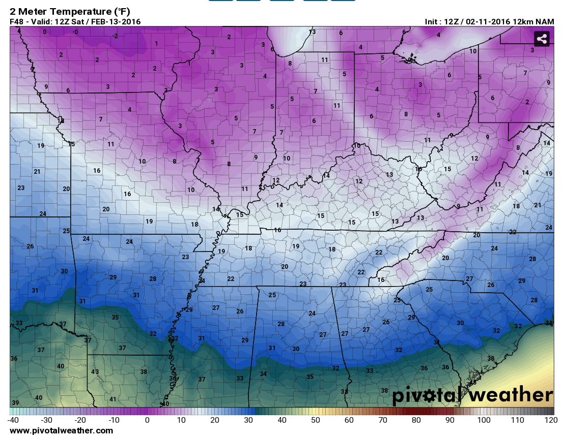
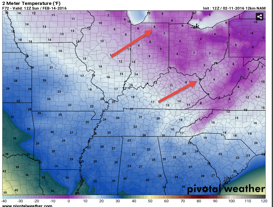
And, here are the Sunday morning temperatures. Notice the coldest air is shifting north and east. This is in response to a weather system that will move into the region on Sunday morning and afternoon. It will bring slightly warmer temperatures. But, still cold. Cold enough for all snow and sleet.
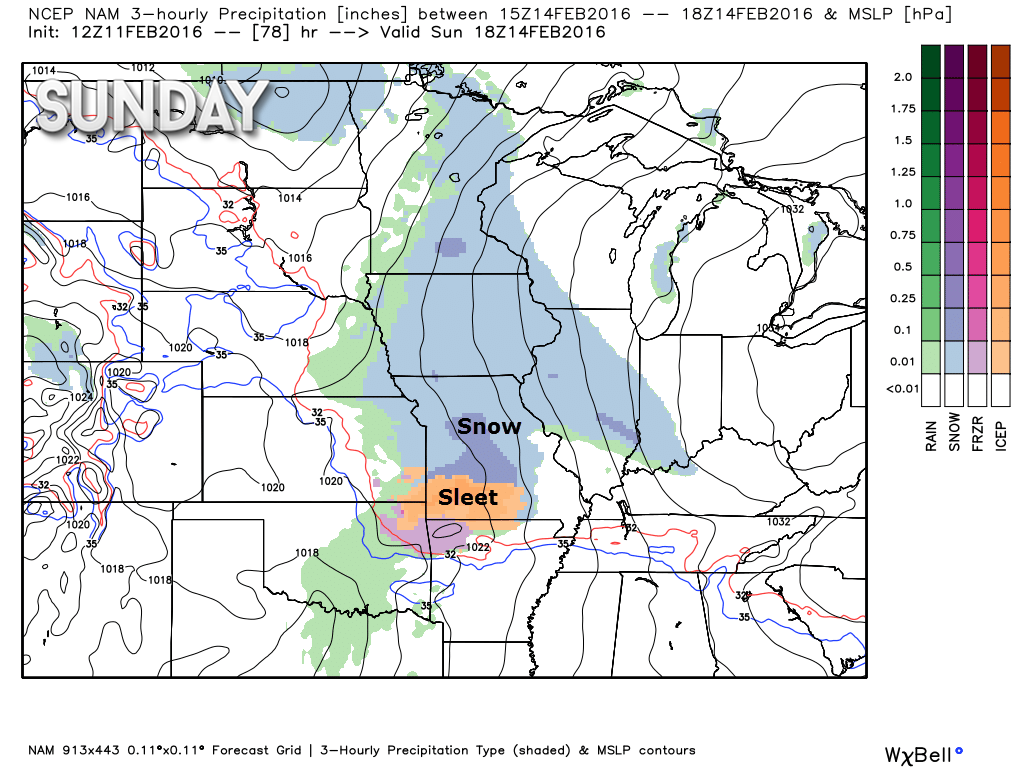
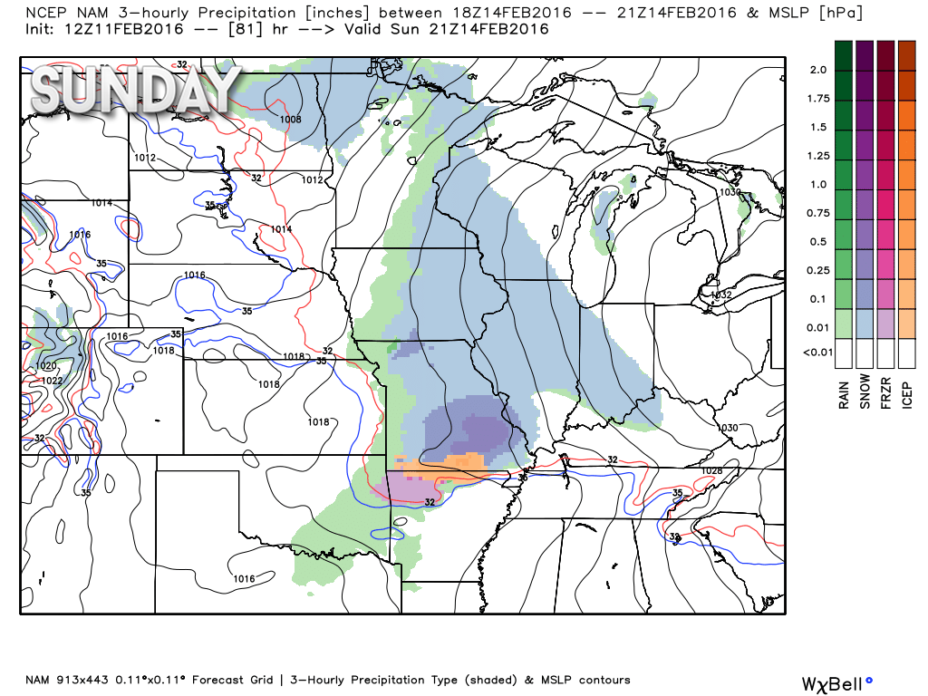
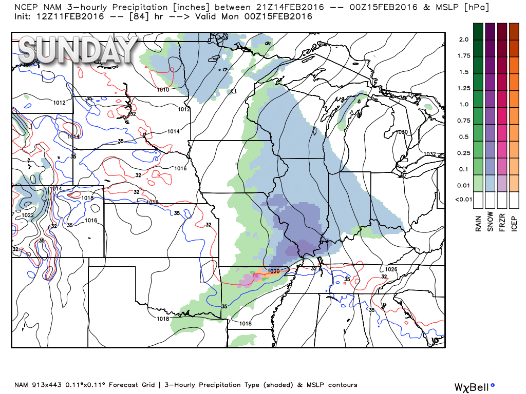
System number two arrives on Sunday morning.
Here is the NAM model guidance showing precipitation. I marked the type of precitation that each color represents.
Keep in mind that it is still early for an exact forecast. The timing of the Sunday system may need to be adjusted in future updates. Give or take 3-6 hours on these maps.
This is for 9 am to 12 pm on Sunday.
Here is the 3 pm map.
Here is the 6 pm map. Again, precipitation may have spread into western Kentucky and northwest Tennessee before this time frame.
System number three is a bit of a headache. The track of this system will be key to what happens in our area. Temperature profiles may warm up enough to support all rain at some point on Monday. Low confidence on how this plays out.
I do believe a wintry mix will be possible late Sunday night and Monday morning. And then it may change to rain. Lot of question marks on late Sunday night and Monday.
Highly questionable on the track for Monday. Track is key to what happens in our local area.
Here is the GFS map. The thick red line is the freezing line. This is for 6 am on Monday morning. You can see precipitation to our southwest. It is moving northeast. Other data spreads precipitation into our region late Sunday night and early Monday morning.
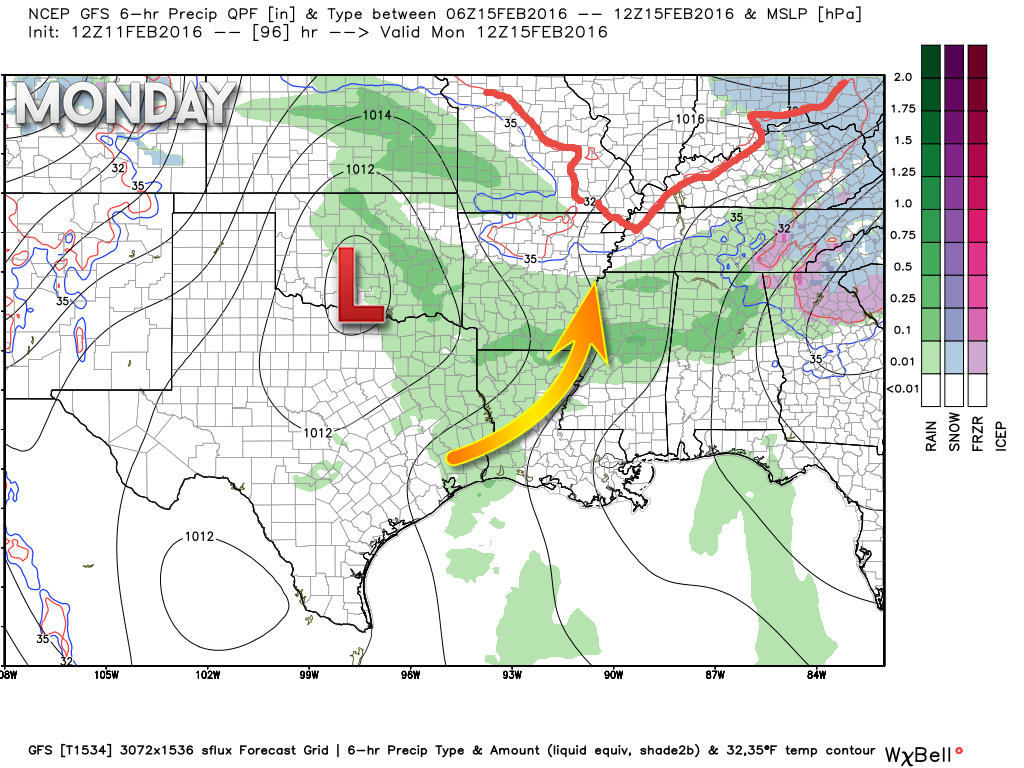
I would suggest monitoring updates concerning Monday’s weather. All modes of precipitation may occur in our local area. Track of the area of low pressure will be key to how much precipitation falls.
Busy few days for the weatherman.
Be sure and check me out on the Beau Dodson Weather Facebook page. Latest updates there.

Light snow possible Thursday night and Friday morning over southern Illinois, southwest Indiana, and western Kentucky. Smaller chances elsewhere.
Sunday – winter storm possible. Snow, sleet, and maybe freezing rain. More likely snow and a little sleet.

Thursday night – Light snow possible over southern Illinois and western Kentucky. Smaller chance over southeast Missouri and northwest Tennessee.
Friday – Light snow possible before 8 am.
Saturday – No snow or ice anticipated.
Sunday – Snow and sleet are possible. High confidence.
Sunday night – Snow, sleet, and freezing rain are possible. Medium confidence.
Monday – Snow, sleet, and freezing rain will be possible at least early in the day. Medium confidence.

No real changes. Did increase snow chances for Thursday night/Friday morning.

Main concern will be snow and sleet over the coming days. Three winter weather events to track. Let’s keep updated on the latest forecast numbers.

Yes, monitor updates concerning winter weather over the coming days.
Be prepared for slick roads on Sunday and Sunday night/Monday morning.
Some slick roads possible tonight and Friday morning, as well.

Three wild cards in the forecast. First one will be Thursday night and Friday morning. Fast moving clipper could drop a dusting to an inch or two of snow over southern Illinois, southwest Indiana, western Kentucky, and northwest Tennessee. The wild card will be totals.
Second wild card will be the timing of snow and sleet on Sunday. Morning? Or early afternoon? Data is a bit mixed on this. Right now, I believe snow and sleet will spread into southeast Missouri before 10 am. Then spread eastward.
Third wild card is a big one. Sunday night (late) and Monday’s precipitation type. Will it be warm enough for rain? I believe it could be warm enough, at some point, on Monday for rain. But, not before snow and sleet/freezing rain at the beginning of the system.

How much precipitation should we expect over the next few days?
Light snow is possible Thursday night and Friday morning. Likely between 9 pm and 8 am. Centered on the wee morning hours. Snowfall accumulations of a dusting to an inch or so will be possible over southern Illinois, southwest Indiana, and western Kentucky.

Can we expect severe thunderstorms over the next 24 to 48 hours? Remember that a severe thunderstorm is defined as a thunderstorm that produces 58 mph winds or higher, quarter size hail or larger, and/or a tornado.
The thunderstorm threat level will be a ZERO through Thursday.

Here is the official 6-10 day and 8-14 day temperature and precipitation outlook. Check the date stamp at the top of each image (so you understand the time frame).
The forecast maps below are issued by the Weather Prediction Center (NOAA).


The latest 8-14 day temperature and precipitation outlook. Note the dates are at the top of the image. These maps DO NOT tell you how high or low temperatures or precipitation will be. They simply give you the probability as to whether temperatures or precipitation will be above or below normal.


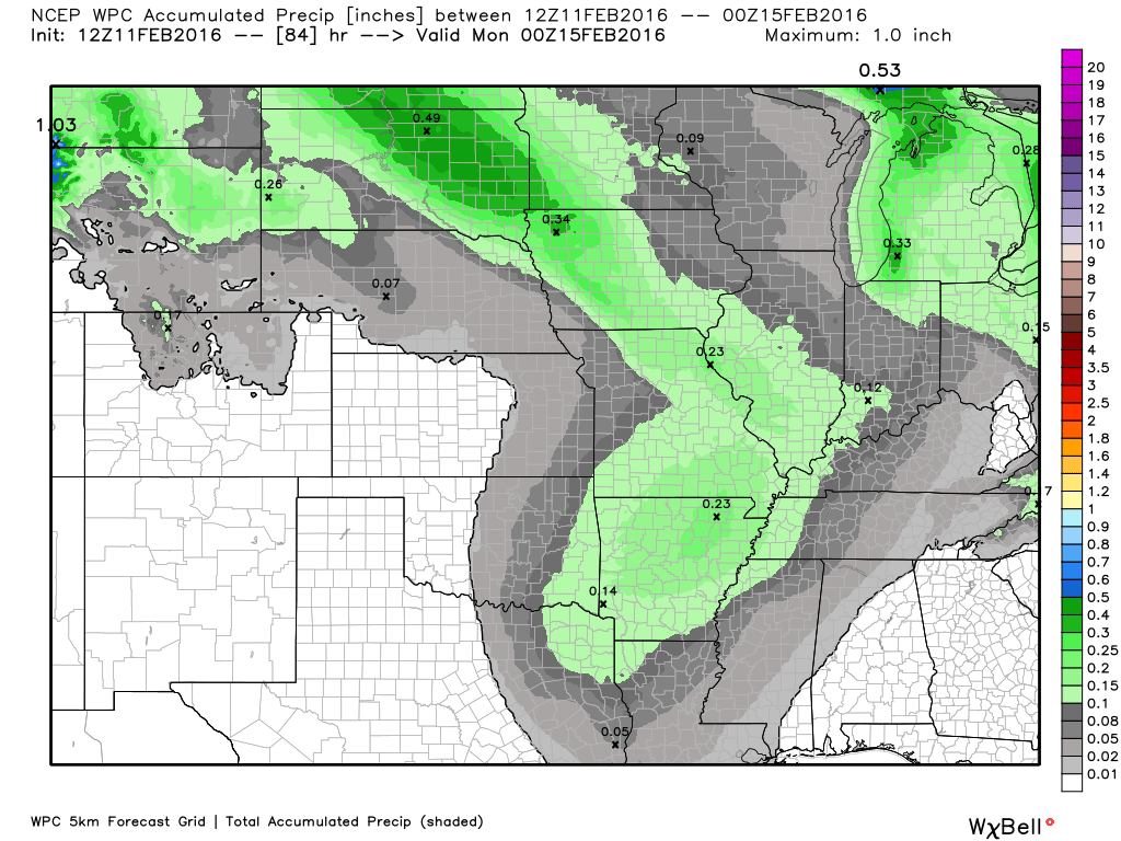
Here are the current river stage forecasts. You can click your state and then the dot for your location. It will bring up the full forecast and hydrograph.
Click Here For River Stage Forecasts…

Who do you trust for your weather information and who holds them accountable?
I have studied weather in our region since the late 1970’s. I have 37 years of experience in observing our regions weather patterns. My degree is in Broadcast Meteorology from Mississippi State University and an Associate of Science (AS). I am currently working on my Bachelor’s Degree in Geoscience.
My resume includes:
Member of the American Meteorological Society.
NOAA Weather-Ready Nation Ambassador.
Meteorologist for McCracken County Emergency Management. I served from 2005 through 2015.
I own and operate the Southern Illinois Weather Observatory.
Recipient of the Mark Trail Award, WPSD Six Who Make A Difference Award, Kentucky Colonel, and the Caesar J. Fiamma” Award from the American Red Cross.
In 2009 I was presented with the Kentucky Office of Highway Safety Award.
Recognized by the Kentucky House of Representatives for my service to the State of Kentucky leading up to several winter storms and severe weather outbreaks.
I am also President of the Shadow Angel Foundation which serves portions of western Kentucky and southern Illinois.
There is a lot of noise on the internet. A lot of weather maps are posted without explanation. Over time you should learn who to trust for your weather information.
My forecast philosophy is simple and straight forward.
- Communicate in simple terms
- To be as accurate as possible within a reasonable time frame before an event
- Interact with you on Twitter, Facebook, and the blog
- Minimize the “hype” that you might see on television or through other weather sources
- Push you towards utilizing wall-to-wall LOCAL TV coverage during severe weather events
I am a recipient of the Mark Trail Award, WPSD Six Who Make A Difference Award, Kentucky Colonel, and the Caesar J. Fiamma” Award from the American Red Cross. In 2009 I was presented with the Kentucky Office of Highway Safety Award. I was recognized by the Kentucky House of Representatives for my service to the State of Kentucky leading up to several winter storms and severe weather outbreaks.
If you click on the image below you can read the Kentucky House of Representatives Resolution.

Many of my graphics are from www.weatherbell.com – a great resource for weather data, model data, and more


You can sign up for my AWARE email by clicking here I typically send out AWARE emails before severe weather, winter storms, or other active weather situations. I do not email watches or warnings. The emails are a basic “heads up” concerning incoming weather conditions.