We have our first sponsor for the blog. Milner and Orr Funeral Home and Cremation Services located in Paducah, Kentucky and three other western Kentucky towns – at Milner and Orr they believe in families helping families.
![]()

This forecast update covers far southern Illinois, far southeast Missouri, and far western Kentucky. See the coverage map on the right side of the blog.
Remember that weather evolves. Check back frequently for updates, especially during active weather.
Thursday – Partly sunny. Cold. Low wind chills. Windy. Chance for a period of snow flurries and snow showers. Highs only in the 20’s. Wind chills in the single digits during the morning and teens during the afternoon. NW morning winds at 10-20 mph becoming north/northwest at 10-15 during the afternoon hours. Winds will be gusty at times. My confidence in this part of the forecast verifying is high
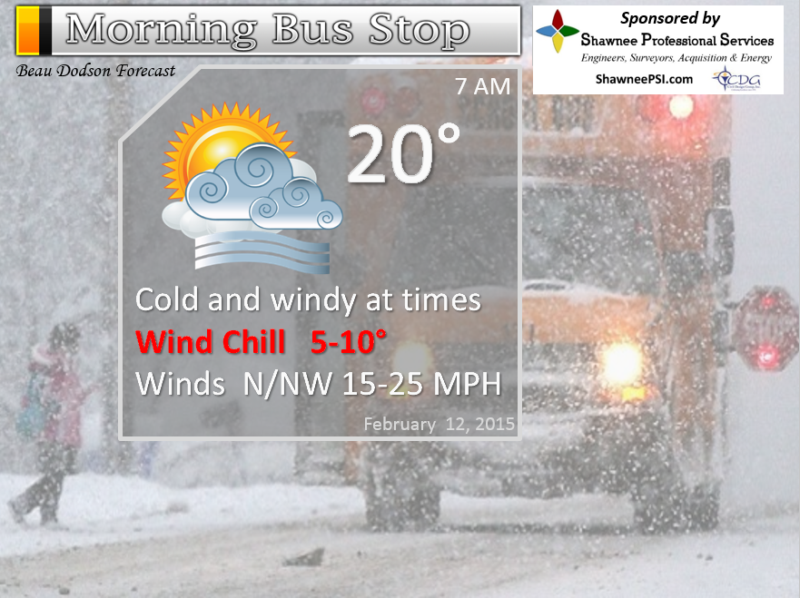
Morning School Bus Stop Weather – Partly cloudy and windy. Very cold wind chills. Wind chills in the single digits. Small chance for a flurries. Temperatures in the teens and lower 20’s. Northwest winds at 10-25 mph and gusty. Chances of schools being delayed because of the weather 0%
—————————————————————————————-
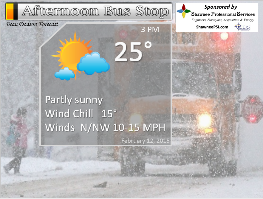
Afternoon School Bus Stop Weather – Partly cloudy. Cold. Small chance for a flurry. Temperatures in the 20’s. Northwest winds at 10-20 mph. Wind chills in the teens.
Thursday night – Cold. Clouds. Lows in the teens. Winds from the north at 10 mph. My confidence in this part of the forecast verifying is
Friday – Partly sunny and cold. Chance for a snow shower or flurry. High temperatures in the 30’s. Southerly winds becoming southwest at 5-10 mph. Gusts to 15 mph in open areas. My confidence in this part of the forecast verifying is high
Friday night – Becoming clear. Cold. Lows in the 20’s. West winds at 10 mph. My confidence in this part of the forecast verifying is high
Saturday – Clouds increasing. Turning colder and windy by afternoon with some snow showers possible during the day. Morning temps may reach into the 40’s then temperatures falling into the 20’s in the afternoon and evening. Wind chills in the single digits by late afternoon and evening. Winds becoming northwest at 10-20 mph and gusty. My confidence in this part of the forecast verifying is medium
Saturday night into Sunday – turning bitterly cold. Wind chills well below zero with strong and gusty north/northwest winds. Snow showers possible. Winds will gust above 30 mph as the front moves through the area late Saturday afternoon and Saturday night. Temperatures will fall into the single digits by Sunday morning. Sunday highs will be in the teens and 20’s for most of the area.
We will need to closely monitor a possible system on Sunday/Sunday night now, as well. Latest data indicated some chance for snow developing over Missouri and Arkansas and moving into our counties. Stay tuned on that one.
Monday into Tuesday – see extended discussion concerning the winter storm potential (rain or snow/ice).

The School Bus Stop Forecast is brought to your by Shawnee Professional Services. For more information click here

Shawnee Professional Services & Civil Design Group have been providing Land Surveying, Engineering, Grant Administration and Acquisition services for the past 20 years.
Currently Licensed in Illinois, Kentucky, Missouri, Indiana, and Tennessee; please contact Shawnee for any Land Surveying or Engineering needs.
Shawnee’s company size allows them to devote individual attention to each client and to approach each project with the required thoroughness to successfully complete the project, large or small.
Shawnee combines innovative thinking and proven techniques, completing projects cost-effectively for their clients. Visit Shawnee’s website at shawneepsi.com for more information. Shawnee has offices in Paducah, KY, Vienna, IL and Benton, IL.
Current Temperatures Around The Local Area


An explanation of what is happening in the atmosphere over the coming days…
A cold front moved through the area on Wednesday. This cold front brought clouds, a wind shift, and obviously colder temperatures.
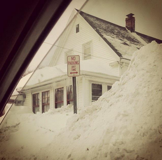
As you venture out this morning you will notice that the 40’s and 50’s are no longer with us. They packed up and hit the road. They won’t be returning anytime soon. Winter is about to say – HELLO, I am still here.
Snow flurries or snow showers will be possible today. Nothing major…but you might see some flakes flying around.
We will have on and off clouds into Friday. Maybe a stray snow flurry here or there, as well. Nothing major. It will be cold through the period.
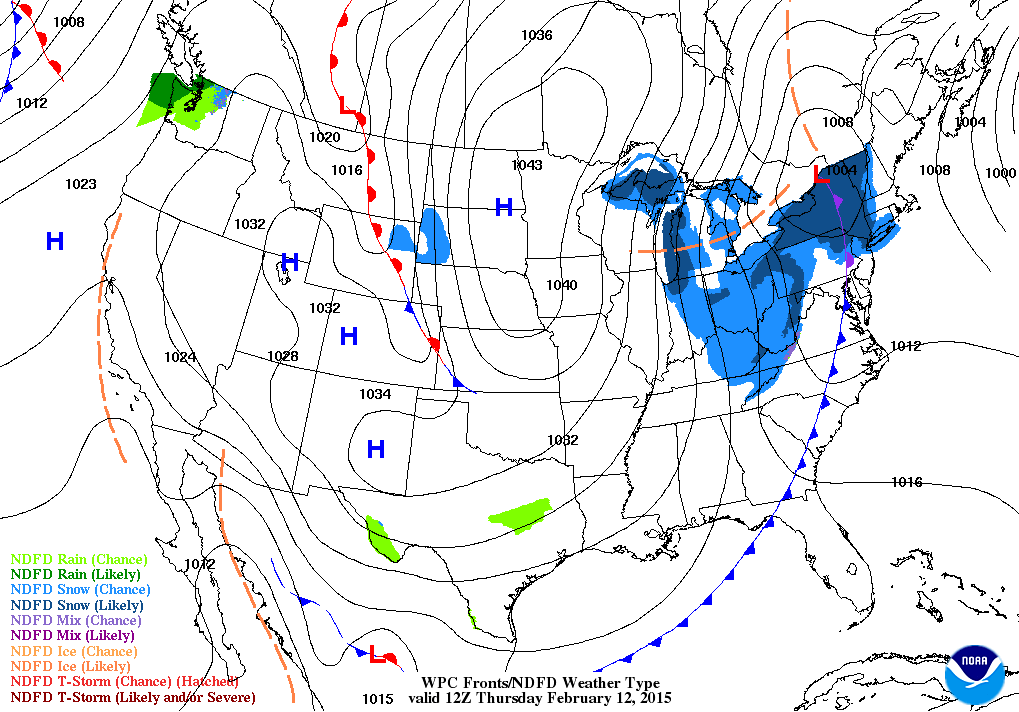
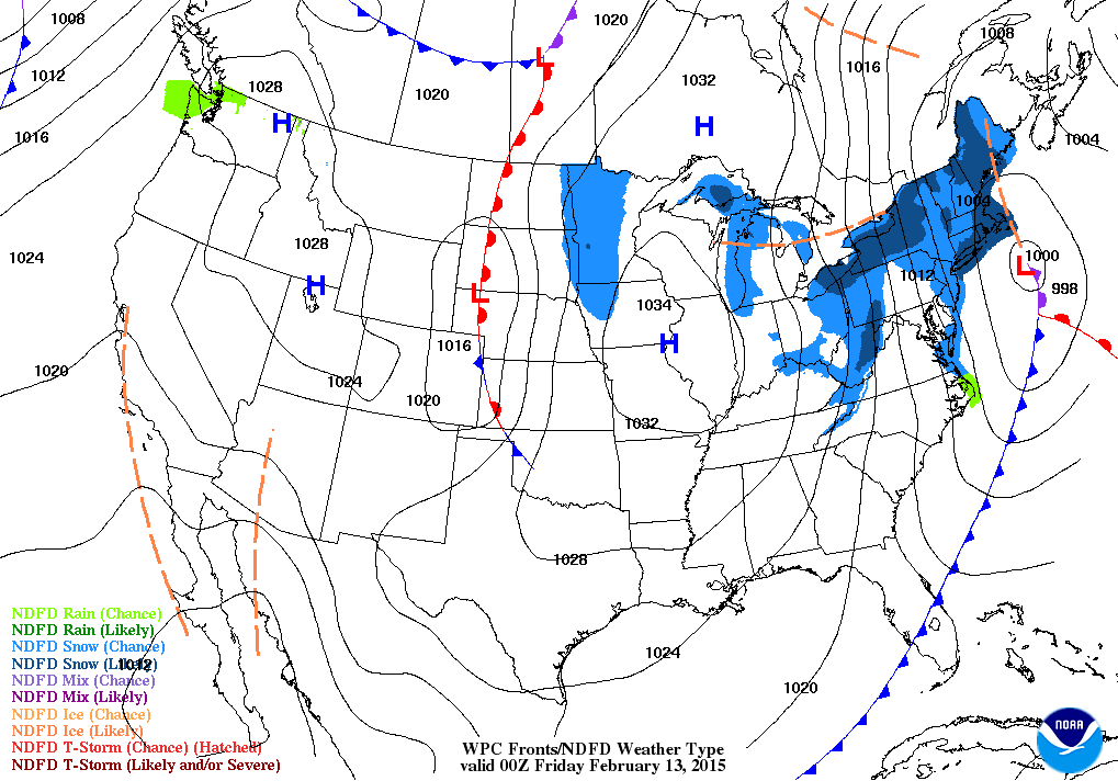
Here is the Thursday morning weather map and Thursday evening weather map
A stronger cold front arrives on Saturday. Snow showers are possible with that front and much colder air.
Morning temperatures may warm into the 40’s over far southern Illinois and western Kentucky. Further north temperatures may stay in the 30’s. By afternoon temperatures will fall (behind the front).
Winds will become gusty from the northwest on Saturday. Winds will gust above 30 mph at times. Temperatures will fall during the afternoon hours on Saturday and by Sunday morning they will likely be in the single digits to lower teens over the region.
Wind chills will be an issue on Saturday into Sunday morning. Wind chills below zero will occur.
I am monitoring a piece of energy on Sunday. Not sure what to do with it yet. I may have to add snow into the forecast on Sunday and Sunday night if some of the data is correct. Not ready to do that just yet. Monitor updates.
A winter storm will move towards our region on Monday and Tuesday. This is the system I started talking about last week. I love it when a forecast plan comes together. But, details remain murky. Will this system bring rain to our local area? Snow to our area? Ice? All three? See the extended discussion for details.
Don’t forget tonight is bluegill night at the Cat Fish House 🙂 – they are one of our blog sponsors!

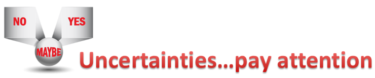
The uncertainties part of the e-journal spells out where I am not confident in the forecast. I always tell people to pay attention to the whole forecast and not just the part they want to hear.
There are some uncertainties on the potential for snow showers over the coming days. The best chance is likely going to be along the cold front on Saturday into Saturday night. Perhaps even Sunday. Very strong/gusty winds will accompany the front. Temperatures will fall into the single digits by Sunday morning.
Another uncertainty is a piece of energy that is showing up on the NAM model for Sunday. It breaks snow out over Missouri and Arkansas during the day on Sunday and spreads it eastward.
The other uncertainties surround next weeks storm system. The system I have been tracking since last week is coming more and more into focus. It does appear there will be a weather event in and near our region.
Questions remain on storm track and intensity. Will this be a rain to snow event? Will this be an ice event and snow? Will it be mostly rain. All of those questions remain unanswered at this point. Still too soon. Winter storms are tricky to forecast one day in advance – let alone five days in advance.
Stay tuned for updates as we move forward.

WANT TO HELP SUPPORT THIS BLOG AND COVER EXPENSES?
Did you know that the Weather Observatory is funded by people like you? I rely on ad’s on this blog and individual donations. PayPal also allows you to set up a monthly recurring donation. I have had several people give $5, $10, and $20 a month. A recurring donation helps keep the weather information flowing. If you enjoy this blog, the Twitter account, the Facebook interaction, the weather radars, and all of the other information then consider making a donation or setting up a recurring donation (if you don’t use PayPal then contact me through email about how you can mail a donation) beaudodson@usawx.com
Or mail a check to
Beau Dodson
3954 Mermet Road
Belknap, IL
62908
Thank you for your support!

We have a new spot that will appear on the blog from time to time – Ask The Weatherman
Mrs. Tiffany Blazina (Curriculum Coach – Middle School and High School) contacted me about answering some questions from some of the students from the Crittenden County Middle School in Marion, Kentucky. Home of the Rockets!
Mrs. Mattea Meadows, Language Arts teacher, led this project and is teaching the class about meteorology. They sent me a few questions.

This question is from Ashton Binkley:
How do you predict this winter will be for western Kentucky?
Well, winter is slowly slipping away from us. Last year we had a lot of snow and ice. Many of you were out of school for 10-20 days! That is pretty amazing for this region. Typically you have a few snow days.
We have experienced some cold shots over the last two months. Overall, December was warmer than average and brought some precipitation, but no major snowstorms. January ended up colder than normal and drier than normal. Again, with no major snowstorms.
Drought is developing over parts of western Kentucky and far southern Illinois. That is how dry it has been.
My winter forecast was for drier than normal weather and below normal temperatures. We will have to wait and see how that pans out (spring does not start until March 20th).
For the rest of the winter I am forecasting colder than normal conditions. I am forecasting a more active storm track starting next week. What does a more active storm track mean?
Typically our weather systems come from two directions. We have clipper systems (areas of low pressure) that dive down out of Canada and push into the Ohio Valley. These areas of low pressure cause light rain and snow. Often times we end up with clouds with little precipitation. Occasionally one of these clippers will dump a decent snow in our region, but not often.
The second area that I watch for precipitation events would be the southwest United States. This is typically where are big winter storms develop. Sometimes these southwest storms bring rain and thunderstorms. It all depends on the track of the area of low pressure.
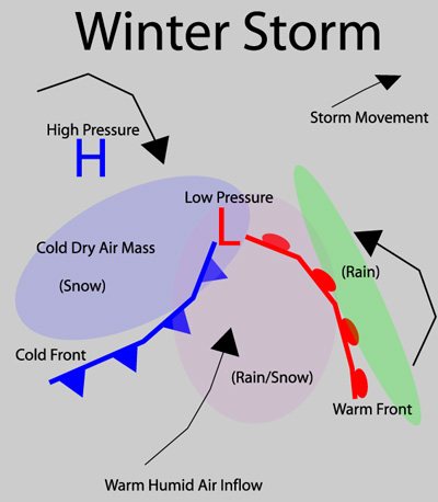
A winter storm can be made up of all types of precipitation. Severe weather can occur on the southern end of a winter storm, heavy rains in the middle, and snow/ice over the north.
Here are a couple of diagrams of winter storms – note the snow to the north, rain in the middle, and thunderstorms to the south.
Can you find the warm front? Cold front? Area of low pressure?
Click image for a larger view

Here is another example (labeled)
We have a system coming up this weekend and next week that will certainly remind us that winter is not over. The weekend system will be a cold front with perhaps some snow showers. The big story will be the cold air and gusty winds. Temperatures by Sunday morning will fall into the single digits over much of the area. Lower teens elsewhere. Wind chills will be well below zero on Saturday evening into Sunday morning. Bundle up weather.
The other system will arrive on Monday into Tuesday. This will be coming out of the Northern Plains and the southwest United States. It might bring rain and snow/ice to our region. Too soon to say for sure. Precipitation type will depend on the track of the area of low pressure.
If the low goes too far south then we won’t have much precipitation at all. We need the low to track through Arkansas into Tennessee/Mississippi. That is how we end up with big snow in this region. Still too early to make a call on next weeks snow or rain event.
I am forecasting colder than normal weather for the second half of February and a more active storm track. That means several precipitation events will be possible in our region.
I suspect we end up with a lot of NW flow. That means the jet stream will be diving down out of Canada into our region. When that happens we will end cold. Not saying we won’t have some milder days, but the colder days should outnumber the milder days over the next 2 weeks.
I am forecasting March to be colder than normal. I don’t have a forecast for March precipitation. I will have to update that part of the forecast as we move forward.
We may see snow in March. Snow in March usually does not last very long (temperatures tend to warm up quickly around here as we move later into March). But, we can experience some big snow events in March. Historically it is possible. We will have to wait and see if this March can produce a snow event.
Although this winter has brought a lot of cold weather it certainly has not brought snow. A snow-less winter for most locations. Yes, there have been some light events (maybe an inch or so here and there) but widespread snow has been absent in our region. A bit unusual.
Now, if you want to see BIG snow then you just have to turn on The Weather Channel and watch the coverage coming out of the northeast United States. Record snowfall for many locations. If you love snow then New England is the place to be. Have any of you been watching the coverage of the snow in the northeast United States? Do any of you have family in the northeast? Maybe they can mail us some snow!
Some locations in New England have received more than 70″ of snow over the past 2 weeks. Historic snowfall totals. Perhaps a once in a lifetime event?
The system next week is the best chance for snow that we have seen over the past two months. But, never count your snowflakes before they hatch. It will all come down to the track of the area of low pressure. Stay tuned.
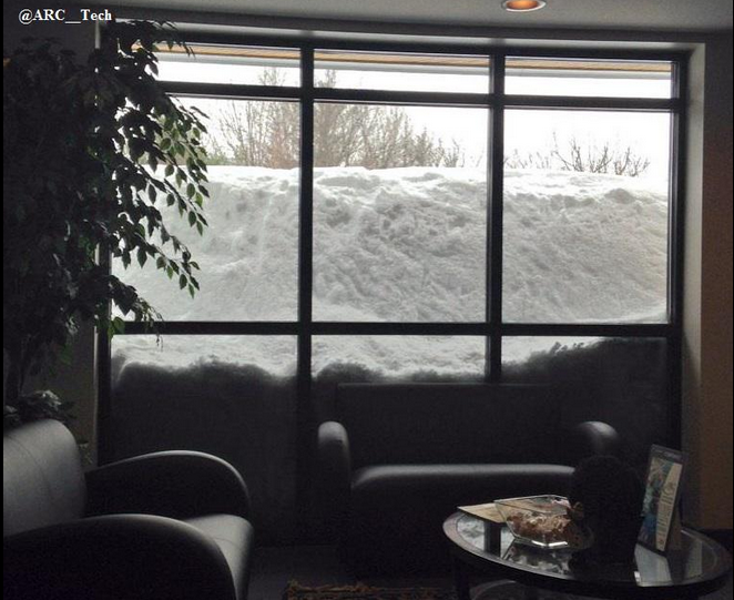
Here are a couple of snow photos from Massachusetts – found on Twitter yesterday


Made some changes to the discussion on next weeks storm. The latest data takes it so far south that we miss out on precipitation on Monday and Tuesday. Keep this in mind. Track is key for next weeks storm.
Also Sunday is starting to look like it might produce some snow.

Bitterly cold wind chills today with gusty northwest winds. Wind chills this morning (Thursday morning) will be in the single digits over many counties. Winds will gust in the 15-30 mph range.
Check out our newest sponsors $5 meal! The DQ Grill and Chill (located across from Noble Park in Paducah, Kentucky) is the newest WeatherTalk Blog sponsor! A local business helping to sponsor the weather information that you have come to love so much.
They have a Facebook Page and I encourage you to check it out. DQ Grill and Chill on Facebook


The wild card tells you where the uncertainties are in the forecast
Wild card in this forecast – whether we might see some flurries or light snow showers over the coming days. Model data spits out some small amounts. Some might see a few flakes here and there. There are some very small disturbances moving through the flow. Also…each cold front has a little bit of lift with it

Can we expect severe thunderstorms over the next 24 to 48 hours? Remember that a severe thunderstorm is defined as a thunderstorm that produces 58 mph winds or higher, quarter size hail or larger, and/or a tornado.
Thunderstorm threat level is ZERO. This has been one of the longer stretches during the winter, that I can remember, without thunderstorms.


Will I need to take action?
Bitterly cold air on Thursday morning for the children going to school. Wind chills in the single digits to lower teens. Bundle up weather!

How much precipitation should we expect over the next few days?
Light snow showers possible on and off into Saturday. Might not happen, but data does spit out very tiny amounts. So, I will mention it. Nothing major.
I am monitoring Sunday for snow. Not sure on that part of the forecast just yet.
Next week a bigger system moves into the area. Still questions on precipitation type and amounts. Latest data shunts that event WAY WAY south. Might miss us? Possible.
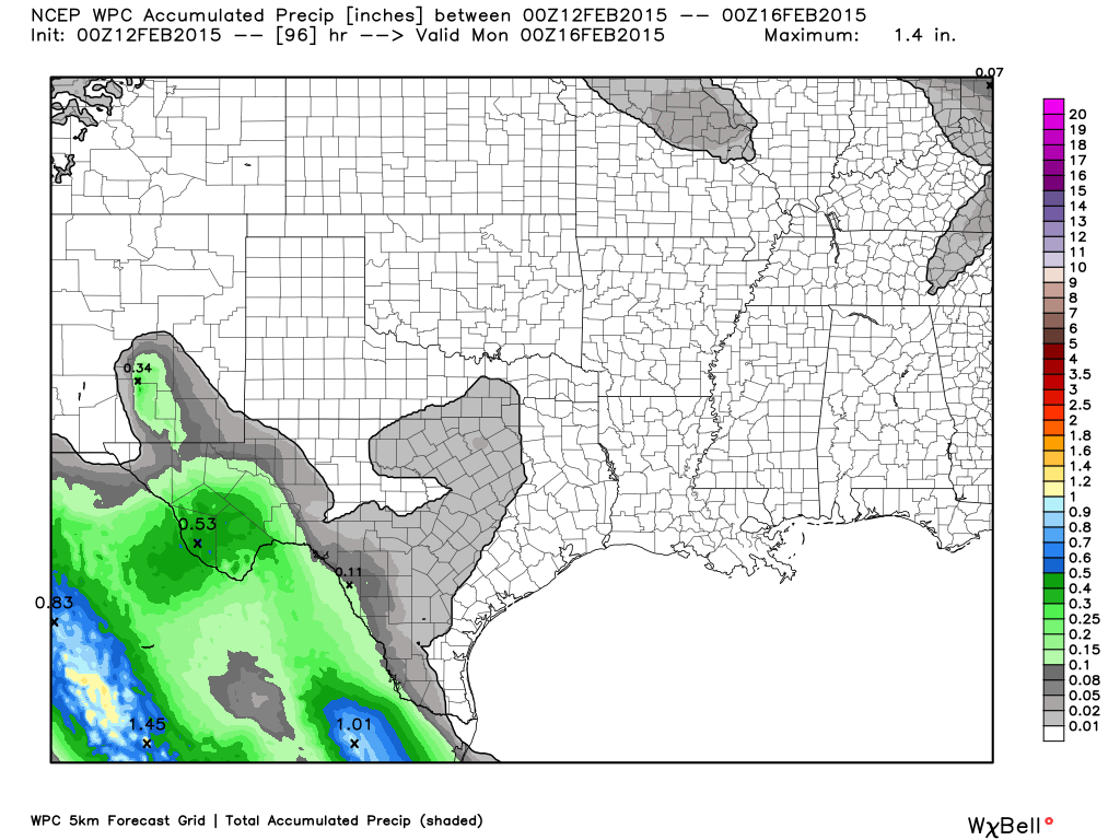
Here is the precipitation forecast through Sunday – note, not much
We have a new sponsor! G&C Multi-Services out of Paducah, Kentucky. G & C Multi-Services is a service provider in Western Kentucky that provides industrial and commercial equipment fabrication, machine troubleshooting, repair and maintenance, and installation. They can custom fabricate steel, stainless, and aluminum products per customer specifications.
Visit their web-site here. Or click the ad below! They have a Facebook page and it can be viewed here.


Snow showers are possible over the coming days. Best chance would be on Saturday. Not expecting anything major
MUCH colder air arrives Saturday night into Sunday. Sunday morning will bring single digits to many of the counties I forecast for.
Some of the latest computer model data indicates snow developing on Sunday. I am not sure what to make of that, just yet. Lot of updates over the coming days.
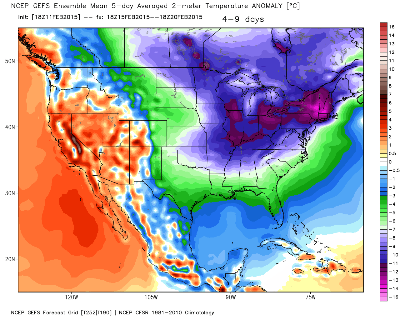
Temperatures from February 15th-20th will average WELL below normal. Here are the departure numbers. Normal highs in our region are around 47 degrees and normal lows are in the upper 20’s. Image is from weatherbell.com
Another system on Monday and Tuesday will need to be watched. Latest model data shunts it way way south. Misses us.
Jim Rasor has a new blog. Check it out when you have time http://mylocalweather.net/forum/home

This section of the blog is speculative forecast information. Because it is past the range of what meteorologists can forecast accurately, it should be considered speculation. Anything past day 5 is considered a long range forecast.
Well, last week I started telling you that this coming weekend and into next week would become active. Colder and active. That is exactly what is going to happen.
What could go wrong with this system to prevent much snow from falling locally?
1. It could track too far south and miss us completely (MON and TUE)
2. The intensity of the storm is weaker than expected
3. There is a small chance the system goes so far north that we end up mostly rain
There are going to be a ton of snowfall prediction maps floating around on the internet. Also, ignore those weather app’s. Those weather app’s are put out by computers. They have no human intervention in the forecast (if you want a great weather app get the WSIL 3 one – they are going to be able to change their forecast manually). That means they are going to spit out all kinds of numbers. People have been showing me app forecasts that indicate 10-15″ of snow will fall over our area. Other app’s are showing all rain. Other app’s are showing 1-2″ of snow. App’s are not humans. They only spit out what a computer tells it to spit out. Could they be right? Yes. Could they be wrong? Yes.
Follow a human forecaster…not a computer.
Much colder air arrives on Saturday and Sunday. I have already talked about the potential for single digits late Saturday night and Sunday morning. Below zero wind chills, as well. Brrr
New computer data also shows snow developing on Sunday. This is a new twist to the weekend forecast. Not sure just yet what to make of the new data. Something I will be monitoring.
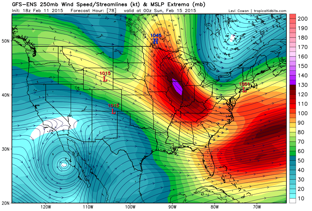
Here is Sunday’s jet stream – strong jet coming out of the northwest
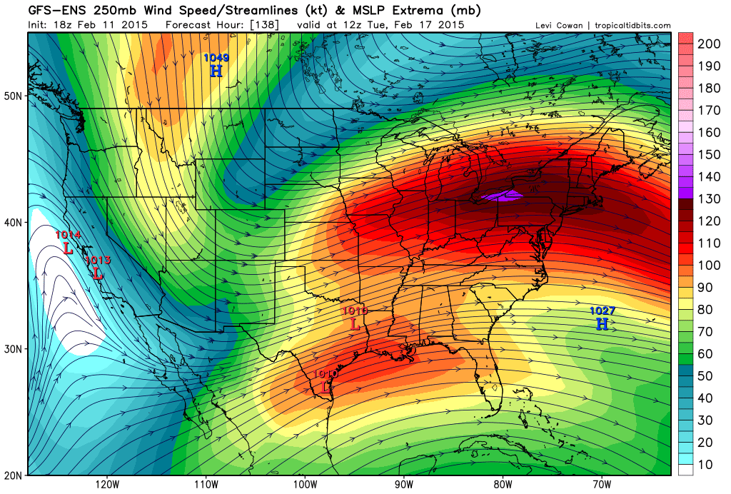
That sets the stage for a battle of sorts on Monday into Tuesday night. A significant precipitation maker appears to be taking shape over the southwest U.S. and northern U.S. These systems will merge near our region. But, questions remain on where.
Latest data is taking this thing so far south that it misses us.
By Monday night and Tuesday the jet stream is coming out of the southwest. That means moisture and quite a bit of it.
What I don’t know…
1. The track of the low. The track of the low is key to what happens here. If it goes too far south then it will miss us. That appears to be a real possibility in the latest data.
2. How cold or warm will it be in our local counties when precipitation begins
3. Will it be ice, snow, or rain? All three?4. How much precipitation will fall. The intensity of the area of low pressure – how organized will it be (or not be)
4. Could this thing go so far south that we end up with only light precipitation vs the heavier totals
Those are four important questions. I won’t have any idea until we push into the weekend. Winter storms are notoriously difficult to forecast days in advance. Basically, it can’t be done. I can throw educated guesses on the table. But that is all they would be.
Most of the data on Wednesday trended colder. That would mean more snow and ice and less rain. The trends were also further south with the area of low pressure. At least on the main models. The ensembles are still all over the place. Which, to some extent – the ensembles are more important to follow than the operational models.
This will be a wait and see. This system may go so far south that we miss out. Keep that in mind.
The data is spitting out quite a bit of precipitation in our region. We need precipitation. That is the good news.
If you have travel plans next week then you will want to closely monitor updated forecasts. I will continue to track the storm and post the latest information.
We may have another system to monitor towards next weekend. Active pattern last half of the month.

Who do you trust for your weather information and who holds them accountable?
I have studied weather in our region since the late 1970’s. I have 37 years of experience in observing our regions weather patterns. My degree is in Broadcast Meteorology from Mississippi State University and an Associate of Science (AS). I am currently working on my Bachelor’s Degree in Geoscience. Just need to finish two Spanish classes!
I am a member of the American Meteorological Society. I am a NOAA Weather-Ready Nation Ambassador. And, I am the Meteorologist for McCracken County Emergency Management.
I own and operate the Southern Illinois Weather Observatory.
There is a lot of noise on the internet. A lot of weather maps are posted without explanation. Over time you should learn who to trust for your weather information.
My forecast philosophy is simple and straight forward.
- Communicate in simple terms
- To be as accurate as possible within a reasonable time frame before an event
- Interact with you on Twitter, Facebook, and the blog
- Minimize the “hype” that you might see on television or through other weather sources
- Push you towards utilizing wall-to-wall LOCAL TV coverage during severe weather events
I am a recipient of the Mark Trail Award, WPSD Six Who Make A Difference Award, Kentucky Colonel, and the Caesar J. Fiamma” Award from the American Red Cross. In 2009 I was presented with the Kentucky Office of Highway Safety Award. I was recognized by the Kentucky House of Representatives for my service to the State of Kentucky leading up to several winter storms and severe weather outbreaks.
If you click on the image below you can read the Kentucky House of Representatives Resolution.

I am also President of the Shadow Angel Foundation which serves portions of western Kentucky and southern Illinois.

We have regional radars and local city radars – if a radar does not seem to be updating then try another one. Occasional browsers need their cache cleared. You may also try restarting your browser. That usually fixes the problem. Occasionally we do have a radar go down. That is why I have duplicates. Thus, if one fails then try another one.
If you have any problems then please send me an email beaudodson@usawx.com
WEATHER RADAR PAGE – Click here —
We also have a new national interactive radar – you can view that radar by clicking here.
Local interactive city radars include St Louis, Mt Vernon, Evansville, Poplar Bluff, Cape Girardeau, Marion, Paducah, Hopkinsville, Memphis, Nashville, Dyersburg, and all of eastern Kentucky – these are interactive radars. Local city radars – click here
NOTE: Occasionally you will see ground clutter on the radar (these are false echoes). Normally they show up close to the radar sites – including Paducah.

Regional Radar – Click on radar to take you our full radar page.


Regional Radar
![]()
Current WARNINGS (a warning means take action now). Click on your county to drill down to the latest warning information. Keep in mind that there can be a 2-3 minute delay in the updated warning information.
I strongly encourage you to use a NOAA Weather Radio or warning cell phone app for the most up to date warning information. Nothing is faster than a NOAA weather radio.


Color shaded counties are under some type of watch, warning, advisory, or special weather statement. Click your county to view the latest information.

Missouri Warnings

Illinois Warnings

Kentucky Warnings

Please visit your local National Weather Service Office by clicking here. The National Weather Service Office, for our region, is located in Paducah, Kentucky. They have a lot of maps and information on their site. Local people…local forecasters who care about our region.


Here is the official 6-10 day and 8-14 day temperature and precipitation outlook. Check the date stamp at the top of each image (so you understand the time frame).
The forecast maps below are issued by the Weather Prediction Center (NOAA).


The latest 8-14 day temperature and precipitation outlook. Note the dates are at the top of the image. These maps DO NOT tell you how high or low temperatures or precipitation will be. They simply give you the probability as to whether temperatures or precipitation will be above or below normal.


Many of my graphics are from www.weatherbell.com – a great resource for weather data, model data, and more


This blog was inspired by ABC 33/40’s Alabama Weather Blog – view their blog
Current tower cam view from the Weather Observatory- Click here for all cameras.

Southern Illinois Weather Observatory

The Weather Observatory

Southern Illinois Weather Observatory
WSIL TV 3 has a number of tower cameras. Click here for their tower camera page & Illinois Road Conditions

Marion, Illinois
WPSD TV 6 has a number of tower cameras. Click here for their tower camera page & Kentucky Road Conditions & Kentucky Highway and Interstate Cameras

Downtown Paducah, Kentucky
Benton, Kentucky Tower Camera – Click here for full view

Benton, Kentucky

I24 Paducah, Kentucky

I24 Mile Point 9 – Paducah, KY

I24 – Mile Point 3 Paducah, Kentucky

You can sign up for my AWARE email by clicking here I typically send out AWARE emails before severe weather, winter storms, or other active weather situations. I do not email watches or warnings. The emails are a basic “heads up” concerning incoming weather conditions.