December 8, 2017
Daily Outlook
December 8, 2017
Friday Forecast Details
Forecast: Mostly sunny during the morning. Some afternoon clouds possible.
Temperatures: MO ~ 36 to 42 IL ~ 36 to 42 KY ~ 38 to 42
Wind chill values: 20 to 30
Accumulating snow or ice: No
Winds: West and southwest winds at 4 to 8 mph during the morning increasing to 7 to 14 mph in the afternoon
What impacts are anticipated from the weather? None
My confidence in the forecast verifying: High
Is severe weather expected? No
The NWS defines severe weather as 58 mph wind or great, 1″ hail or larger, and/or tornadoes
Is freezing rain, sleet, or snow expected? Snow showers are possible
What is the chance of precipitation? MO ~ 0% IL ~ 0% KY ~ 0%
Coverage of precipitation: Most likely none
Should I cancel my outdoor plans? No
.
Friday Night Forecast Details:
Forecast: Increasing clouds. Breezy and cold. Snow flurries or snow showers possible over southern Illinois and western Kentucky. Cold.
Temperatures: MO ~ 23 to 26 IL ~ 24 to 28 KY ~ 24 to 28
Wind chill values: 15 to 23 degrees
Accumulating snow or ice: Small risk for a dusting of snow. Unlikely.
Winds: Southwest to west winds 10 to 20 mph. Gusty winds.
What impacts are anticipated from the weather? Late night snow flurries could cause wet roadways or slick spots.
My confidence in the forecast verifying: High
Is severe weather expected? No
The NWS defines severe weather as 58 mph wind or great, 1″ hail or larger, and/or tornadoes
Is freezing rain, sleet, or snow expected? Snow showers are possible
What is the chance of precipitation? MO ~ 20% IL ~ 40% KY ~ 40%
Coverage of precipitation: Perhaps some scattered snow flurries or snow showers
Should I cancel my outdoor plans: No
.
December 9, 2017
Saturday Forecast Details
Forecast: Morning clouds. Afternoon partly sunny. Flurries and snow showers possible before 12 pm. Little or no accumulation. Breezy.
Temperatures: MO ~ 35 to 40 IL ~ 34 to 38 KY ~ 35 to 40
Wind chill values: 24 to 35
Accumulating snow or ice: Unlikely. Small chance of a dusting.
Winds: Northwest winds at 6 to 12 mph with gusts to 20 mph
What impacts are anticipated from the weather? Small chance of wet roadways or patchy slick spots.
My confidence in the forecast verifying: High
Is severe weather expected? No
The NWS defines severe weather as 58 mph wind or great, 1″ hail or larger, and/or tornadoes
Is freezing rain, sleet, or snow expected? Snow flurries or snow showers are possible
What is the chance of precipitation? MO ~ 10% IL ~ 50% KY ~ 50%
Coverage of precipitation: Scattered
Should I cancel my outdoor plans? No
.
Saturday Night Forecast Details:
Forecast: Clearing. Cold.
Temperatures: MO ~ 16 to 22 IL ~ 16 to 22 KY ~ 20 to 25
Wind chill values: 12 to 20 degrees
Accumulating snow or ice: No
Winds: North and northwest winds at 6 to 12 mph
What impacts are anticipated from the weather? None
My confidence in the forecast verifying: High
Is severe weather expected? No
The NWS defines severe weather as 58 mph wind or great, 1″ hail or larger, and/or tornadoes
Is freezing rain, sleet, or snow expected? Most likely none
What is the chance of precipitation? MO ~ 0% IL ~ 0% KY ~ 0%
Coverage of precipitation: None
Should I cancel my outdoor plans: No
.
December 10, 2017
Sunday Forecast Details
Forecast: Mostly sunny and cold. A few passing clouds.
Temperatures: MO ~ 42 to 46 IL ~ 40 to 45 KY ~ 40 to 45
Wind chill values: 30 to 40
Accumulating snow or ice: No
Winds: Southwest winds increasing to 7 to 14 mph with gusts to 25 mph in the afternoon
What impacts are anticipated from the weather? None
My confidence in the forecast verifying: High
Is severe weather expected? No
The NWS defines severe weather as 58 mph wind or great, 1″ hail or larger, and/or tornadoes
Is freezing rain, sleet, or snow expected? No
What is the chance of precipitation? MO ~ 0% IL ~ 0% KY ~ 0%
Coverage of precipitation: None
Should I cancel my outdoor plans? No
.
Sunday Night Forecast Details:
Forecast: Mostly clear. Cold.
Temperatures: MO ~ 25 to 30 IL ~ 25 to 30 KY ~ 26 to 32
Wind chill values: 22 to 25 degrees
Accumulating snow or ice: No
Winds: Light winds
What impacts are anticipated from the weather? None
My confidence in the forecast verifying: High
Is severe weather expected? No
The NWS defines severe weather as 58 mph wind or great, 1″ hail or larger, and/or tornadoes
Is freezing rain, sleet, or snow expected? None
What is the chance of precipitation? MO ~ 0% IL ~ 0% KY ~ 0%
Coverage of precipitation: None
Should I cancel my outdoor plans: No
.
December 11, 2017
Monday Forecast Details
Forecast: Mostly sunny and not as cold. Some afternoon clouds.
Temperatures: MO ~ 54 to 58 IL ~ 48 to 54 KY ~ 52 to 56
Wind chill values: N/A
Accumulating snow or ice: No
Winds: West and southwest winds at 6 to 12 mph with gusts to 15
What impacts are anticipated from the weather? None
My confidence in the forecast verifying: Medium
Is severe weather expected? No
The NWS defines severe weather as 58 mph wind or great, 1″ hail or larger, and/or tornadoes
Is freezing rain, sleet, or snow expected? No
What is the chance of precipitation? MO ~ 0% IL ~ 0% KY ~ 0%
Coverage of precipitation: None
Should I cancel my outdoor plans? No
.
Monday Night Forecast Details:
Forecast: Partly to mostly cloudy. Light snow or rain showers possible.
Temperatures: MO ~ 26 to 34 IL ~ 28 to 34 KY ~ 28 to 34
Wind chill values: 20 to 25 degrees
Accumulating snow or ice: Unlikely, but monitor updates
Winds: Northwest winds 5 to 10 mph with gusts to 15 mph
What impacts are anticipated from the weather? Monitor updates.
My confidence in the forecast verifying: Medium
Is severe weather expected? No
The NWS defines severe weather as 58 mph wind or great, 1″ hail or larger, and/or tornadoes
Is freezing rain, sleet, or snow expected? None
What is the chance of precipitation? MO ~ 20% IL ~ 30% KY ~ 30%
Coverage of precipitation: Isolated to scattered
Should I cancel my outdoor plans: No
.
December 12, 2017
Tuesday Forecast Details
Forecast: Partly sunny. A chance of flurries. Colder.
Temperatures: MO ~ 38 to 44 IL ~ 36 to 44 KY ~ 38 to 44
Wind chill values: 30 to 40
Accumulating snow or ice: Unlikely
Winds: Northwest 6 to 12 mph with gusts to 18 mph
What impacts are anticipated from the weather? None
My confidence in the forecast verifying: Medium
Is severe weather expected? No
The NWS defines severe weather as 58 mph wind or great, 1″ hail or larger, and/or tornadoes
Is freezing rain, sleet, or snow expected? No
What is the chance of precipitation? MO ~ 20% IL ~ 30% KY ~ 30%
Coverage of precipitation: None to isolated
Should I cancel my outdoor plans? No
.
Tuesday Night Forecast Details:
Forecast: A few clouds. Cold.
Temperatures: MO ~ 23 to 26 IL ~ 23 to 26 KY ~ 24 to 28
Wind chill values: 20 to 25 degrees
Accumulating snow or ice: No
Winds: Northwest winds 5 to 10 mph with gusts to 15 mph
What impacts are anticipated from the weather? Most likely none
My confidence in the forecast verifying: Medium
Is severe weather expected? No
The NWS defines severe weather as 58 mph wind or great, 1″ hail or larger, and/or tornadoes
Is freezing rain, sleet, or snow expected? None
What is the chance of precipitation? MO ~ 0% IL ~ 0% KY ~ 0%
Coverage of precipitation: None
Should I cancel my outdoor plans: No
.
December 13, 2017
Wednesday Forecast Details
Forecast: Mostly sunny.
Temperatures: MO ~ 44 to 48 IL ~ 42 to 46 KY ~ 42 to 46
Wind chill values: N/A
Accumulating snow or ice: No
Winds: Southwest at 5 to 10 mph with gusts to 15 mph
What impacts are anticipated from the weather? None
My confidence in the forecast verifying: Medium
Is severe weather expected? No
The NWS defines severe weather as 58 mph wind or great, 1″ hail or larger, and/or tornadoes
Is freezing rain, sleet, or snow expected? No
What is the chance of precipitation? MO ~ 0% IL ~ 0% KY ~ 0%
Coverage of precipitation: None
Should I cancel my outdoor plans? No
.
Wednesday Night Forecast Details:
Forecast: Partly cloudy. A late night flurry possible.
Temperatures: MO ~ 25 to 30 IL ~ 25 to 30 KY ~ 25 to 30
Wind chill values: 20 to 30 degrees
Accumulating snow or ice: No
Winds: West and northwest winds 5 to 10 mph
What impacts are anticipated from the weather? Most likely none
My confidence in the forecast verifying: Medium
Is severe weather expected? No
The NWS defines severe weather as 58 mph wind or great, 1″ hail or larger, and/or tornadoes
Is freezing rain, sleet, or snow expected? None
What is the chance of precipitation? MO ~ 10% IL ~ 10% KY ~ 10%
Coverage of precipitation: None to isolated
Should I cancel my outdoor plans: No
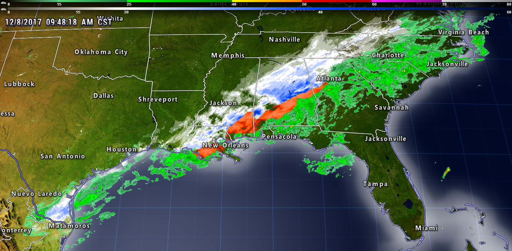
Check out the winter storm to our south. Mexico and Texas received snow last night. That snow is has spread into Louisiana, Mississippi, and Alabama. Then it streams northeast from there.
This is a significant winter storm for those areas. White and blue represent snow. Red would be sleet and freezing rain. Green would be rain.
.
.
.
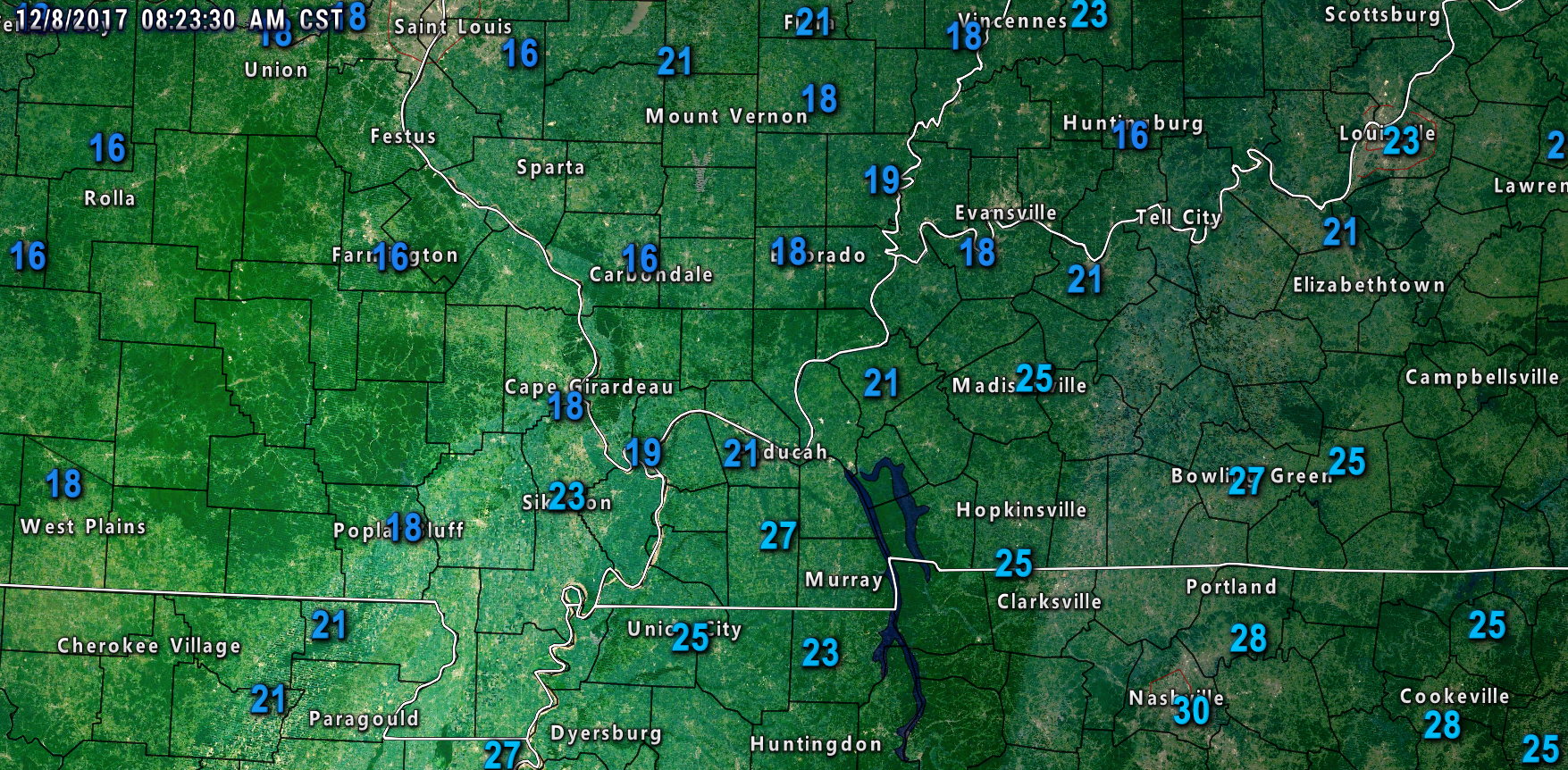
Much of the region dipped into the teens last night. One of the colder mornings of the season, thus far.
Here were the temperatures at 8:30 am. Temperatures have risen a couple degrees off the morning lows.
There were some reporting stations that dipped into the 12 to 15 degree range (not shown on this map and earlier in the morning).
.
.
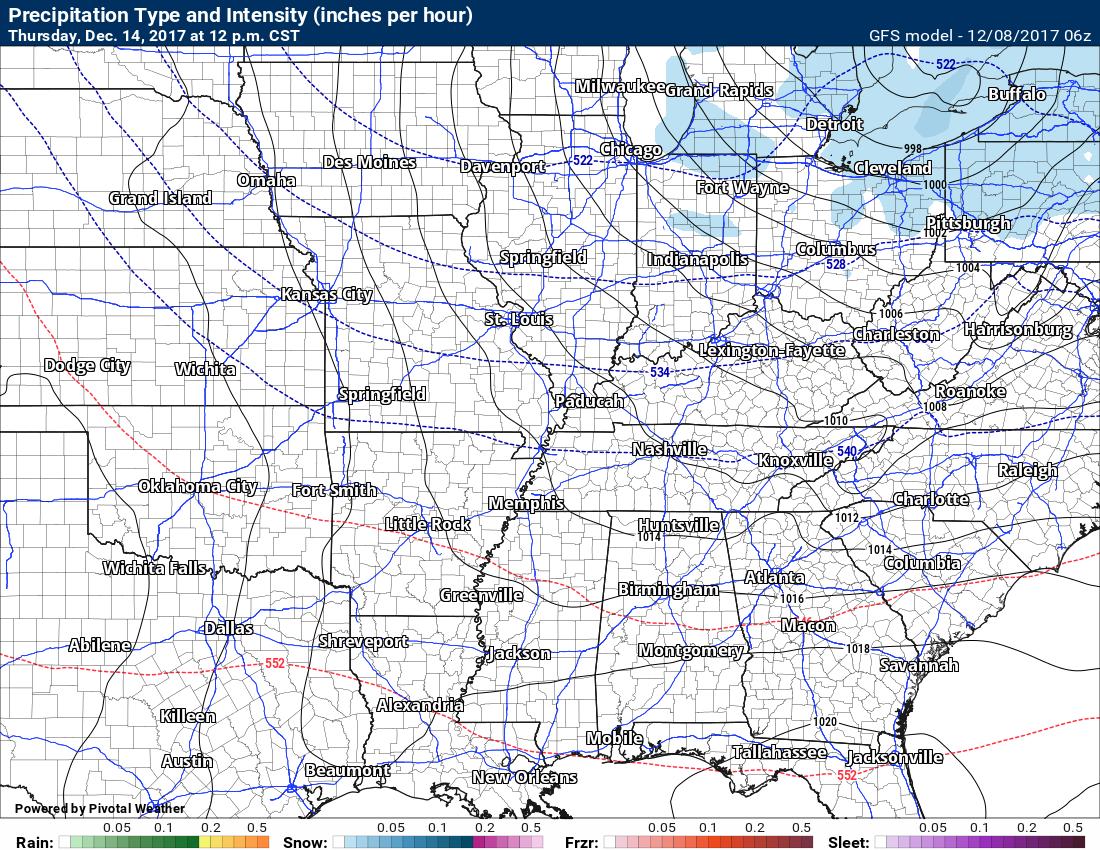
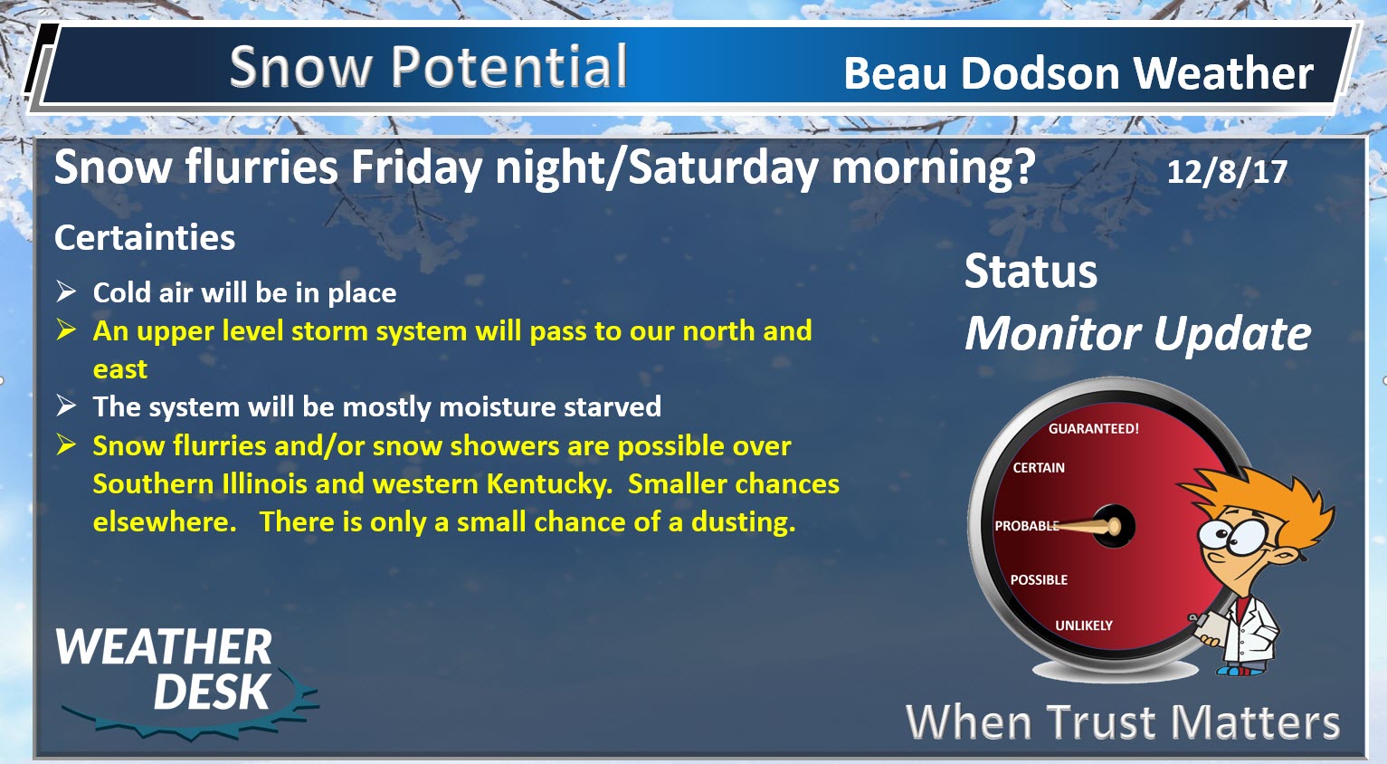
A disturbance will push through the region tonight into Saturday morning. This system will push clouds into our area and a few snow showers or flurries. At this time, it appears unlikely that accumulation will be a concern. I suppose I can’t completely rule out a dusting.
The best chance of snow flurries or snow showers will be over southern Illinois, southwest Indiana, and western Kentucky. The further north and east you travel the more likely you will run into the snowflakes.
Other than that, quiet weather is anticipated through Monday.
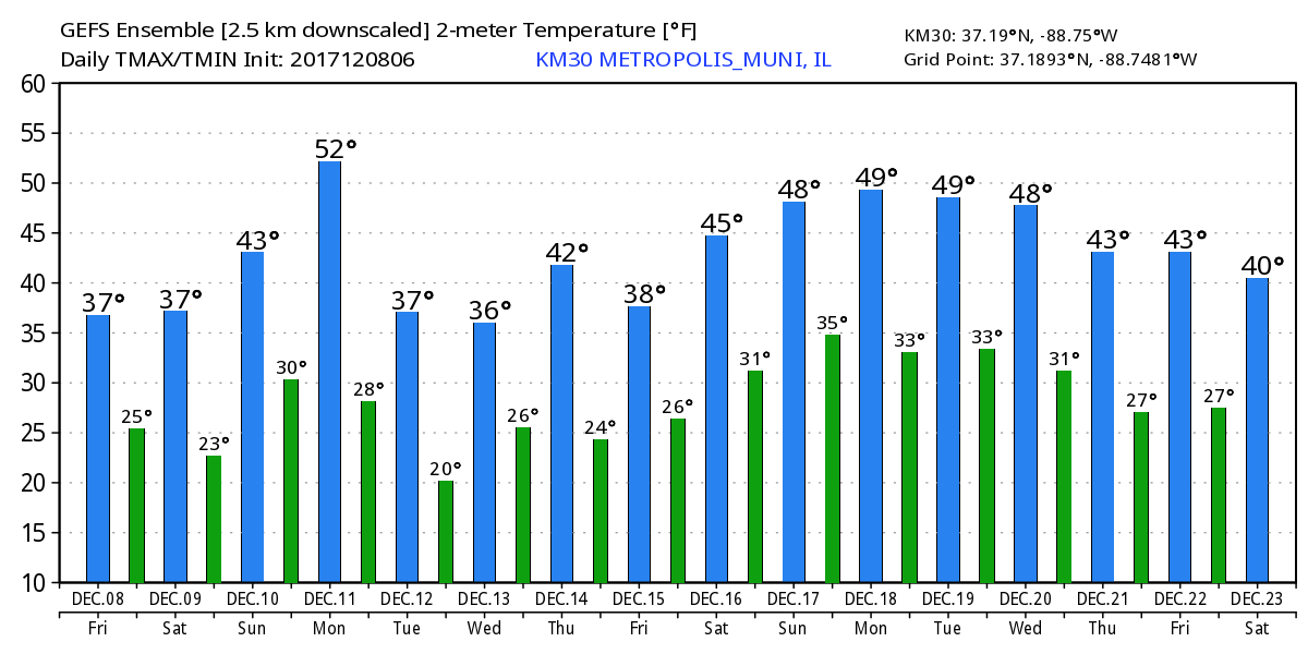
Temperatures will slowly rebound into the 40’s on Sunday and perhaps some 50’s on Monday.
Next Week
Here is the 15 day GFS temperature forecast. Highs and lows.
Keep in mind, this is simply a model. This gives you a general idea of what temperatures will be like over the next few days.
The skill of the model is considerably less once you move past day four or five.
Click images to enlarge
.
.
For the most part, next week is anticipated to be fairly quiet. We will have a couple of cold fronts and weak clippers to monitor.
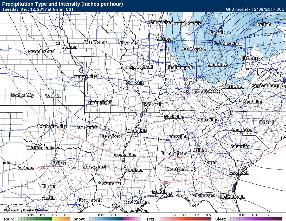
One of those systems will arrive on Monday night and Tuesday morning. This will bring gusty winds and perhaps clouds and flurries. A reinforcing shot of cold air, as well.
Here is the Tuesday weather map. Not much going on. Cold.
You can see the light snow to our northeast. That is the disturbance that could bring some clouds and gusty winds into our region.
.
.
Another cold front is possible around Thursday. That will deliver more clouds and perhaps some flurries.
.
Guidance shows another weak system around Saturday of next week.
No significant winter storms are anticipated through next Friday.
Beau’s Winter Weather Outlook
.
.
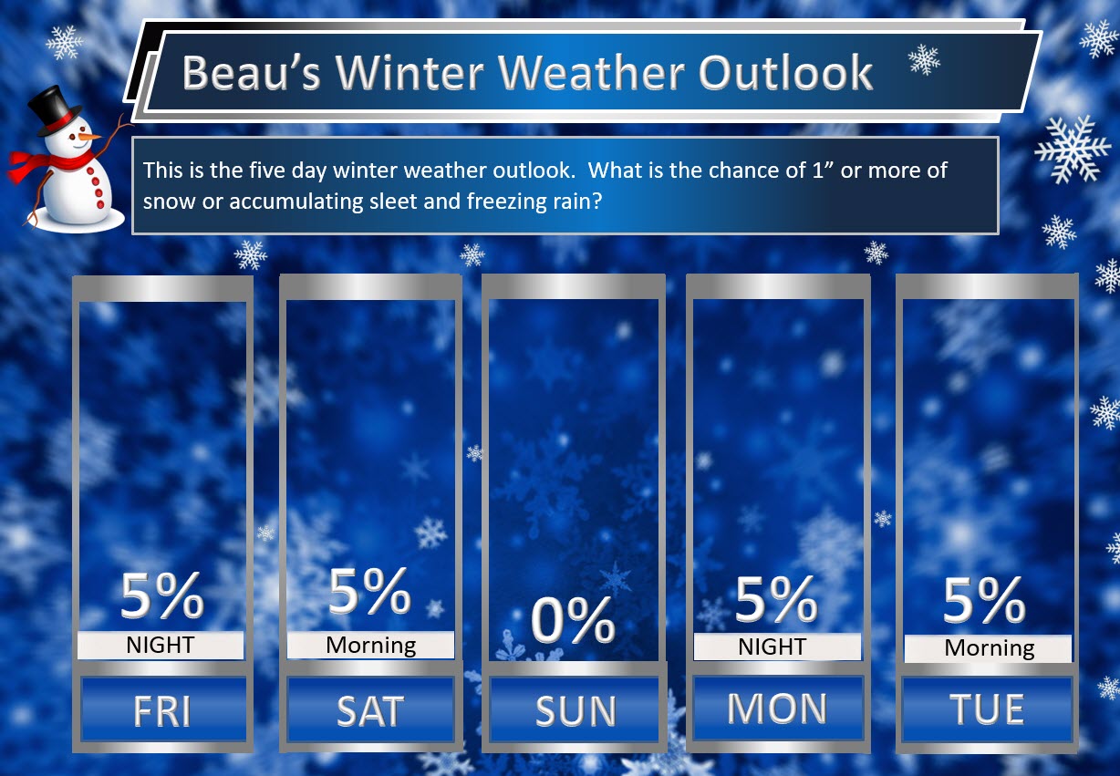
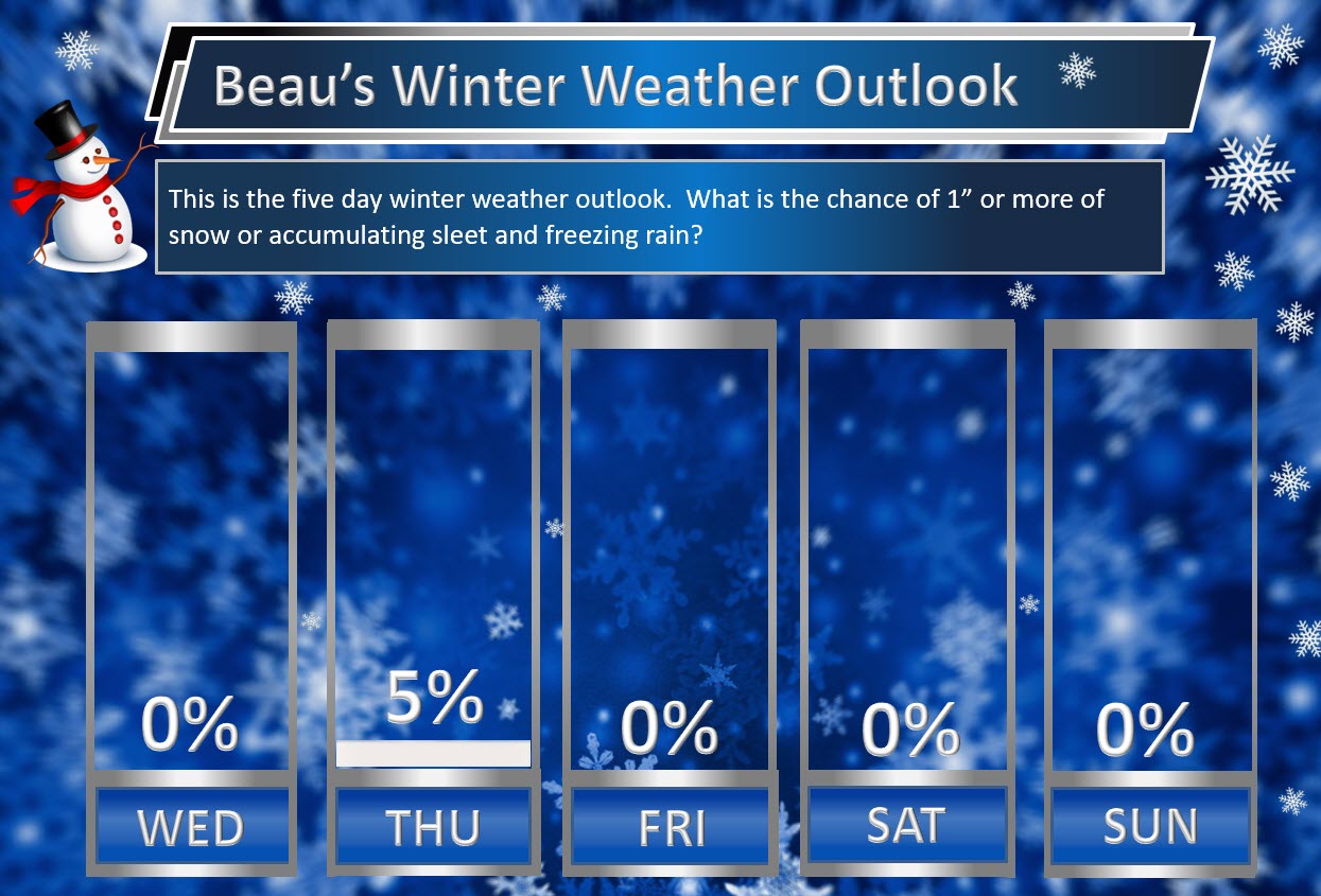
Here are my latest snow probability maps.
These graphics show you the % chance of one inch or more of snow and/or accumulating sleet and freezing rain.
Light snow showers or flurries possible Friday night and Saturday morning. A series of weak disturbances next week could mean sporadic snow flurries or snow showers.
.
.
.


We offer regional radars and local city radars – if a radar does not update then try another one. Occasional browsers need their cache cleared. You may also try restarting your browser. This will usually fix any problems.
During the winter you can track snow and ice by clicking the winterize button on the local city view interactive radars.
You may email me at beaudodson@usawx.com
Interactive Weather Radar Page. Choose the city nearest your location: Click this link
National interactive radar: Click this link.