
Stop what you are doing and do me a favor!
A couple of housekeeping items. I need your assistance with these.
We still have a number of www.weathertalk.comaccounts that have expired cards/PayPal accounts. You would still receive messages because I have to turn those off manually.
Can you sign into your www.weathertalk.comaccount and make sure your payment is active? If it is not active then click the MY ACCOUNT tab and then the yellow button that says make a payment/update payment info.
Thank you
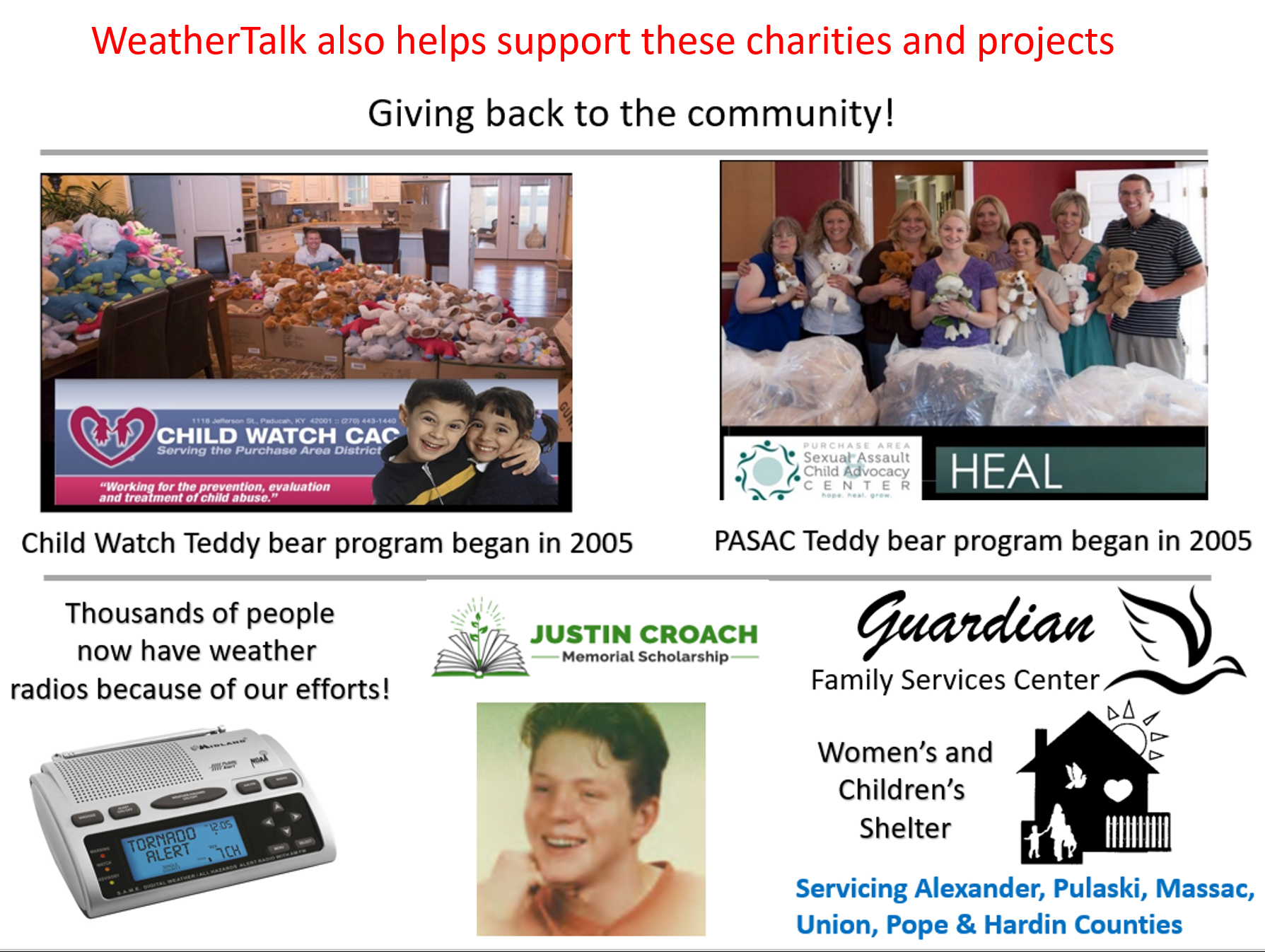
Did you know that your WeatherTalk subscription helps support numerous local charity events?
Check them out at these links
The Justin Croach Memorial Scholarship
Daily WeatherTalk schedule

We offer interactive local city view radars and regional radars.
If a radar does not update then try another one. If a radar does not appear to be refreshing then hit Ctrl F5. You may also try restarting your browser.

Interactive Radars:
Interactive live weather radar page. Choose the city nearest your location. If one of the city radars won’t load then try a nearby one. Click here.
Live satellite views. Click here
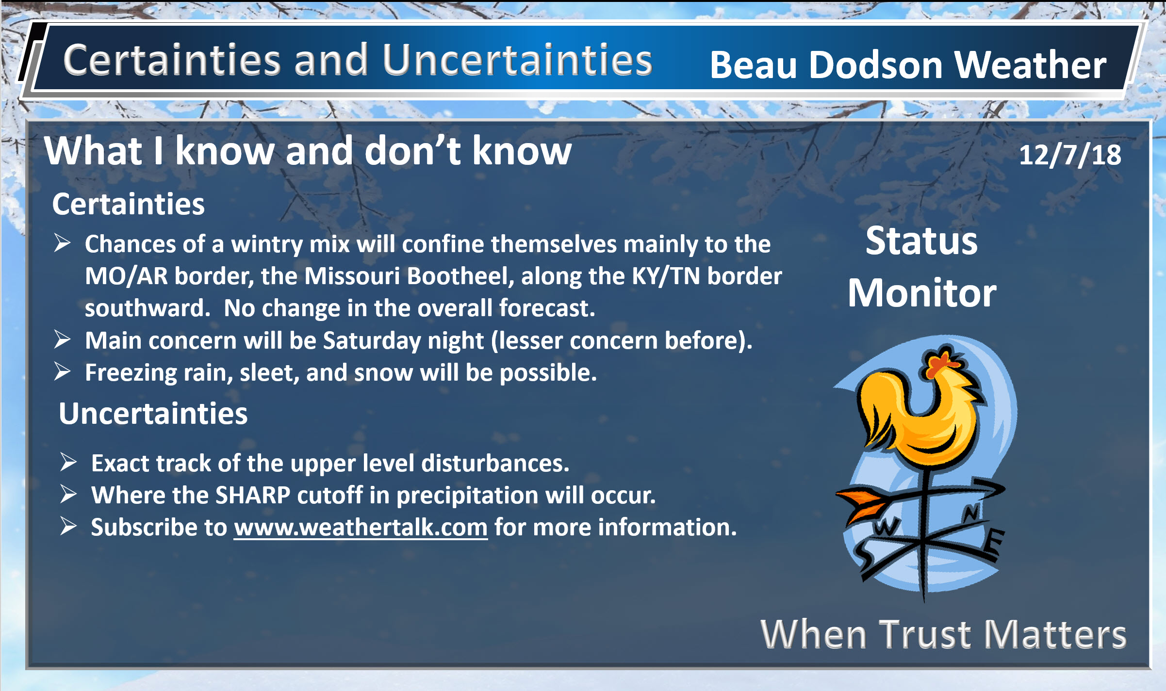
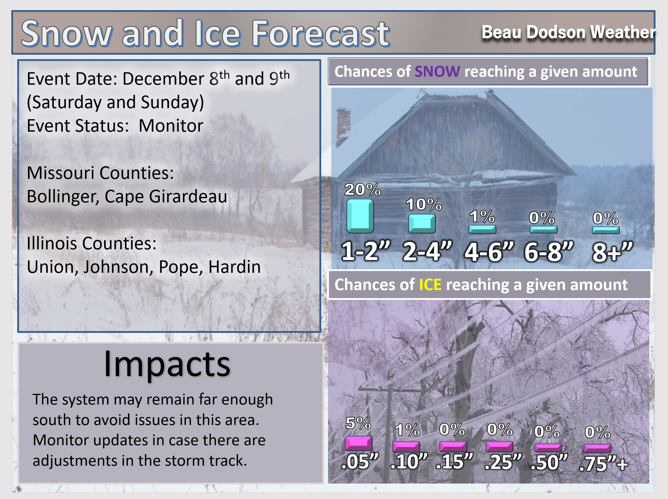
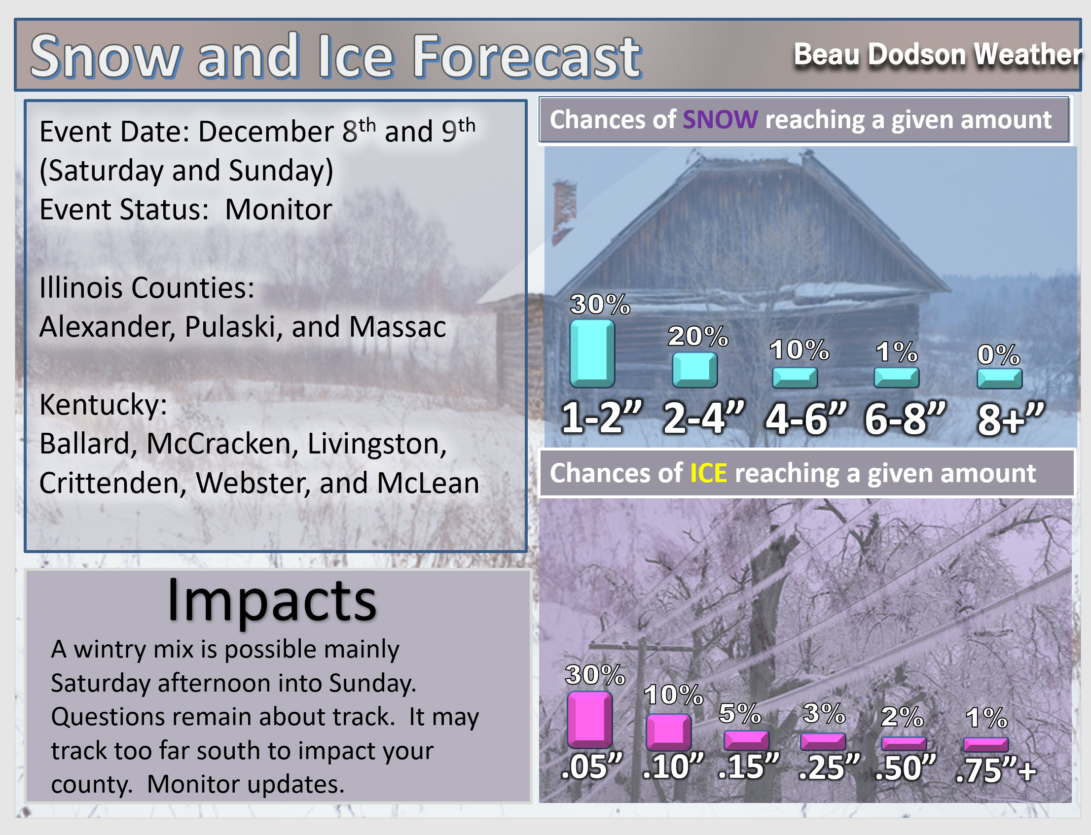
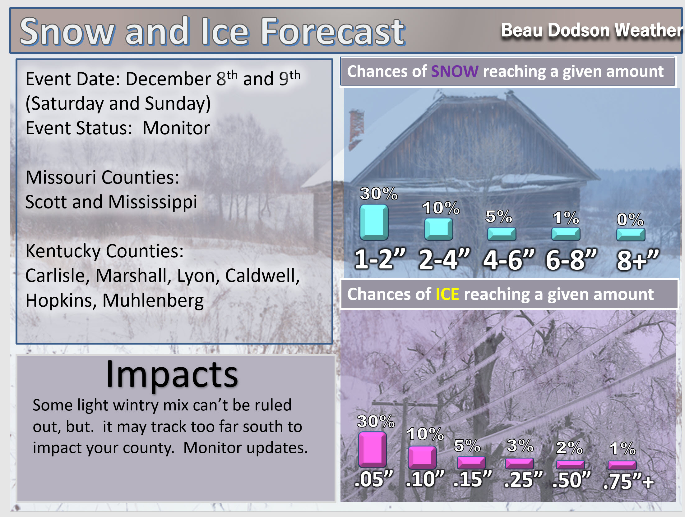
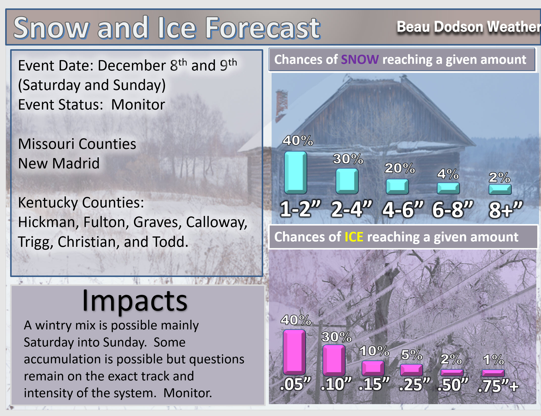
ANY shift in this storm systems track will completely change our local forecast. Monitor updates.
December 7, 2018
Friday forecast: Increasing clouds through the day. A small chance of a snow flurry over southeast Missouri.
My confidence in the forecast verifying: High (70% confidence)
Temperature range: MO ~ 34 to 38 IL ~ 34 to 38 KY ~ 34 to 38 TN ~ 36 to 40
Wind chill (feels like) temperature forecast: 25 to 35
What is the chance/probability of precipitation? MO ~ 10% IL ~ 0% KY ~ 0% TN ~ 0%
Coverage of precipitation: Most likely none for most of the area. Small chance of a flurry over southeast Missouri.
Is flooding anticipated? No
Is accumulating snow or ice anticipated? No
Is non-accumulating snow or ice anticipated? Small chance
Are icy road conditions anticipated? No
Wind direction and speed: Northeast at 7 to 14 mph
What impacts are anticipated from the weather? Most likely none, but monitor updates.
Is severe weather expected? No
The NWS officially defines severe weather as 58 mph wind or great, 1″ hail or larger, and/or tornadoes
Will lightning be possible? No
Should I cancel my outdoor plans? No
Will the weather impact my outdoor plans? For most, no. Monitor parts of southeast Missouri and western Tennessee in case precipitation develops sooner.
UV Index: 1 to 2 Low
Sunrise: 6:56 AM
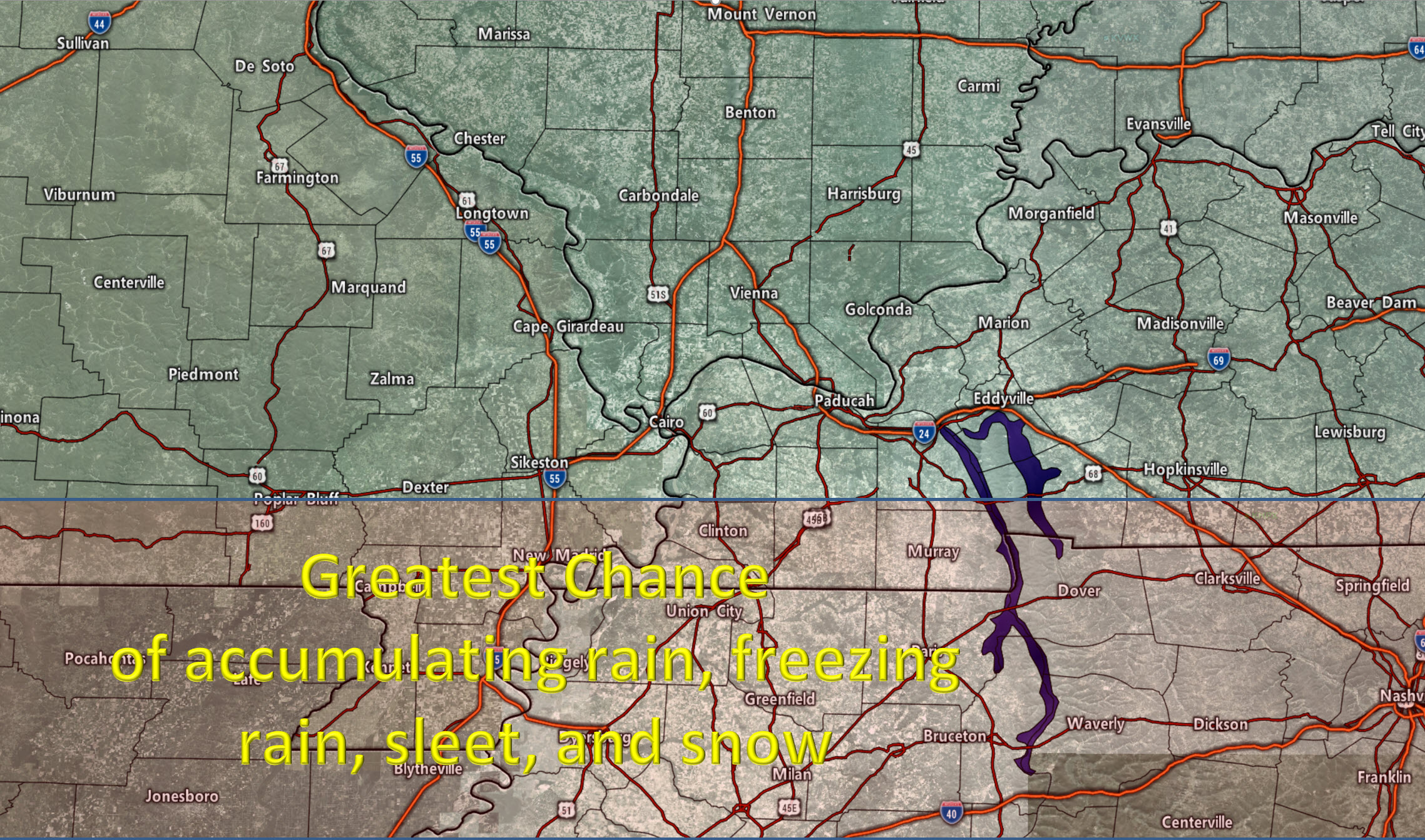
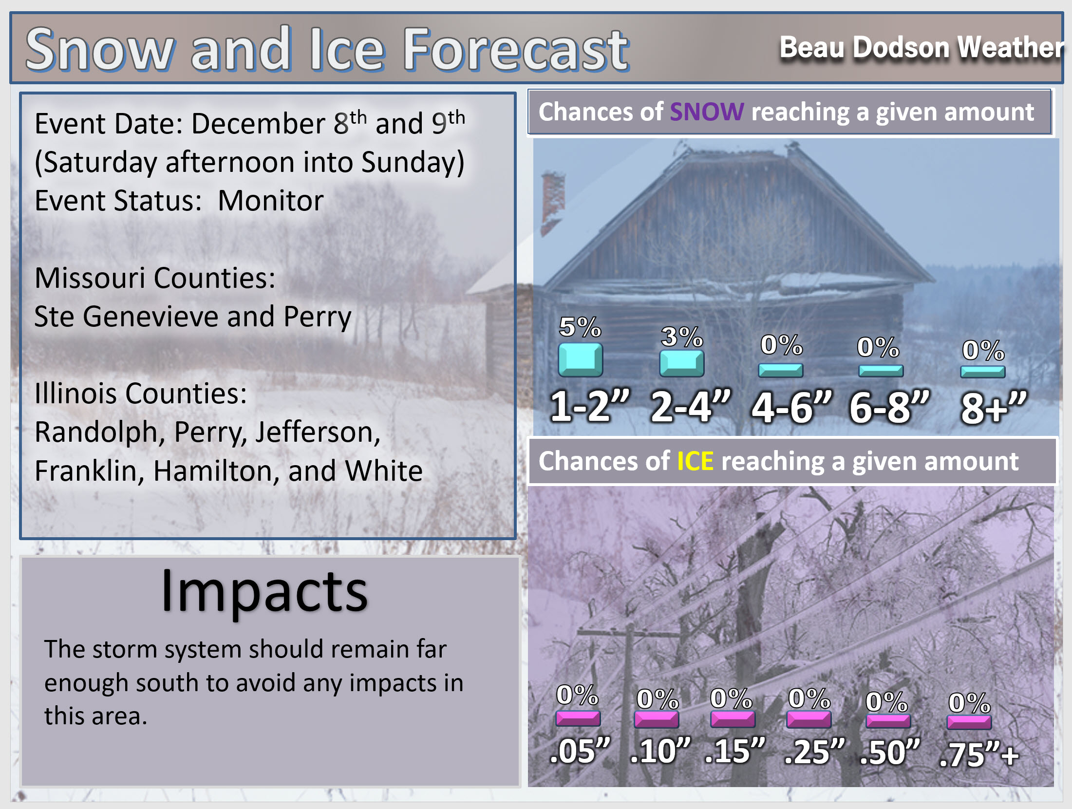
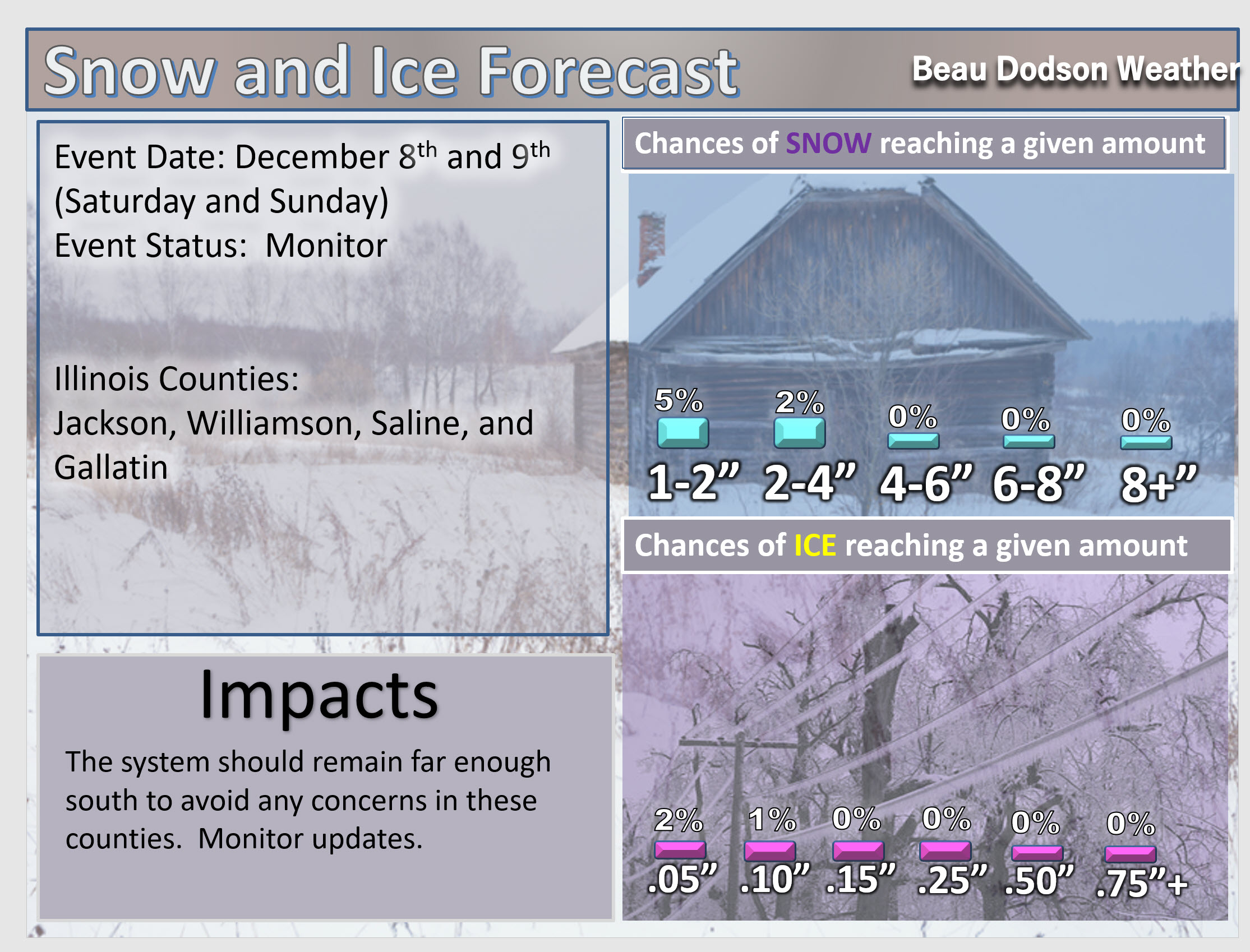
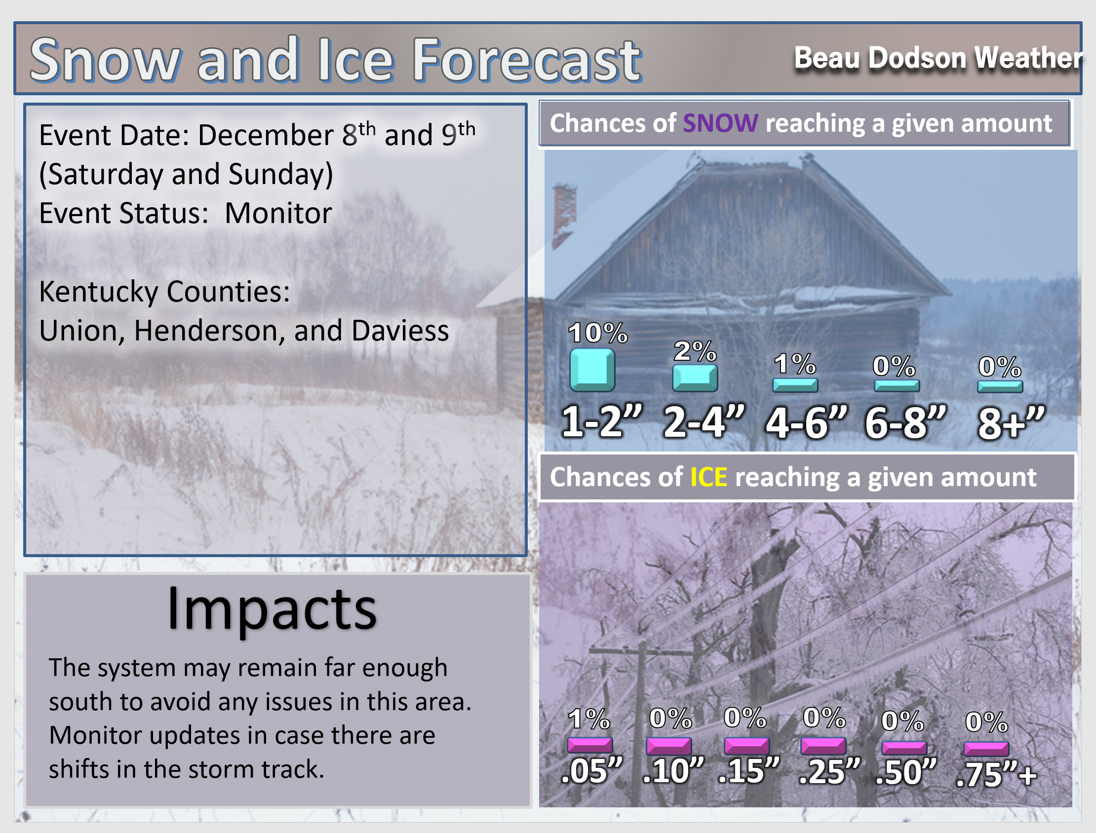
The storm system is taking the southern route, as expected. Remember, it only takes a small amount of ice to cause problems on untreated roadways. The main concern will be along the MO/AR and KY/TN state line southward.
ANY shift further south and all of the area would miss out on precipitation. This remains a question. A 20 to 30-mile shift would change the forecast for our southern counties. Continue to monitor updates.
Friday Night Forecast Details:
Forecast: Partly cloudy northern counties. A chance of a light wintry mix late tonight as you move towards the MO/AR and KY/TN State line. Most areas should remain dry. Monitor radars in case precipitation spreads north a tad. Remember, it only takes a hint of frozen precipitation to cause issues.
My confidence in the forecast verifying: Medium (50% confidence)
Temperature range: MO ~ 23 to 26 IL ~ 22 to 25 KY ~ 25 to 28 TN ~ 28 to 32
Wind chill (feels like) temperature forecast: 10 to 20
What is the chance/probability of precipitation? MO ~ 10% near Farmington, Missouri to 50% over the Missouri Bootheel IL ~ 10% near Mt Vernon, Illinois to 20% as you move towards Metropolis, Illinois KY ~ 20% near Owensboro, Kentucky to 40% near Fulton, Kentucky TN ~ 50%
Coverage of precipitation: None far north is a possibility (Farmington, MO towards Carmi, IL). Scattered near the MO/AR state line. Scattered in western Tennessee.
Is flooding anticipated? No
Is accumulating snow or ice anticipated? None the first half of the night. Some light wintry mix is possible along the MO/AR and KY/TN state line late tonight.
Is non-accumulating snow or ice anticipated?
Are icy road conditions anticipated? Monitor road conditions in the above-mentioned areas.
Wind direction and speed: North at 8 to 16
What impacts are anticipated from the weather? Some icy roads are possible in the above-mentioned areas.
Is severe weather expected? No
The NWS officially defines severe weather as 58 mph wind or great, 1″ hail or larger, and/or tornadoes
Will lightning be possible? No
Should I cancel my outdoor plans? No, but monitor radars late tonight.
Will the weather impact my outdoor plans? Most likely no, but monitor updates.
Sunset: 4:37 PM
Moonrise: 7:02 AM New
Moonset: 5:13 PM
ANY shift in this storm systems track will completely change our local forecast. Monitor updates.
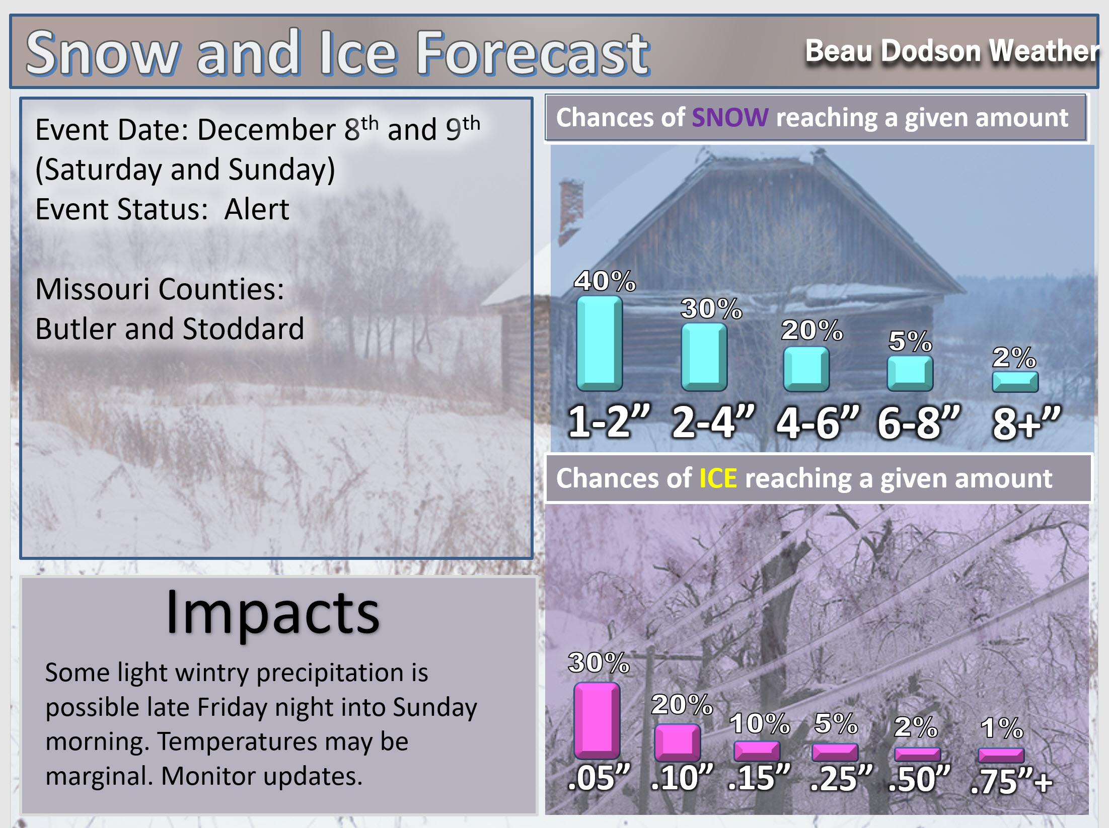
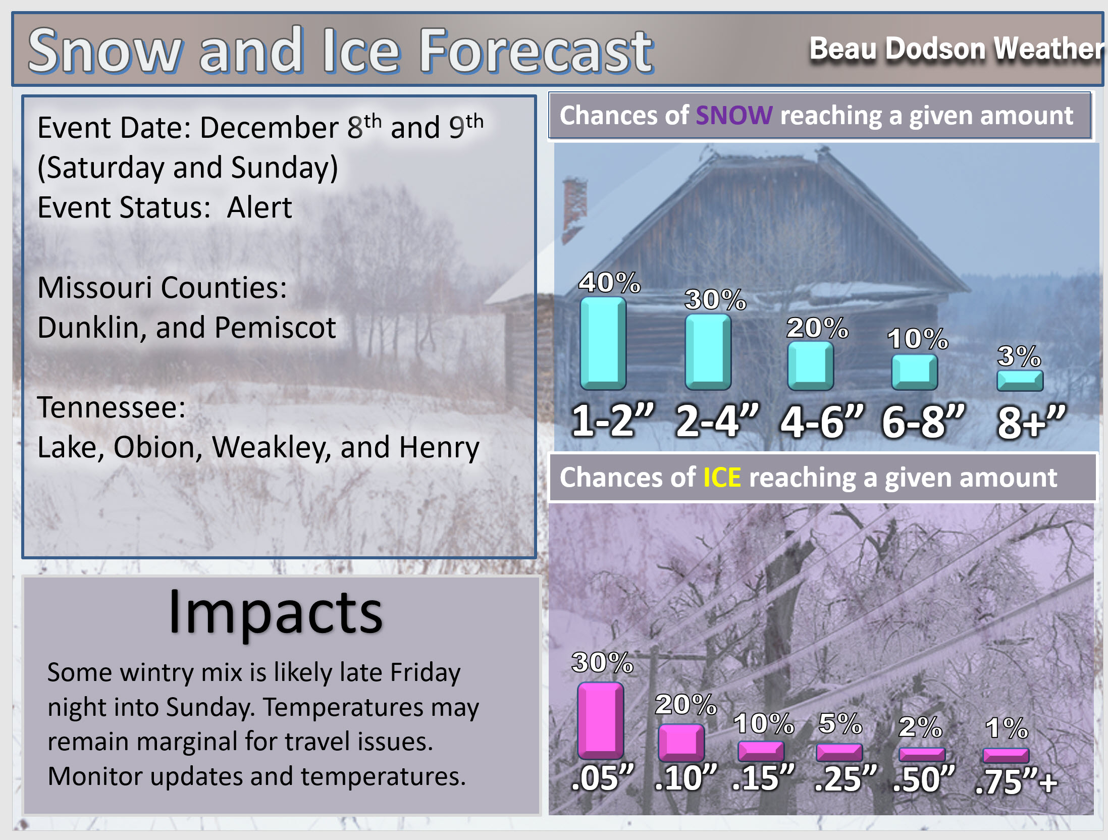
December 8, 2018
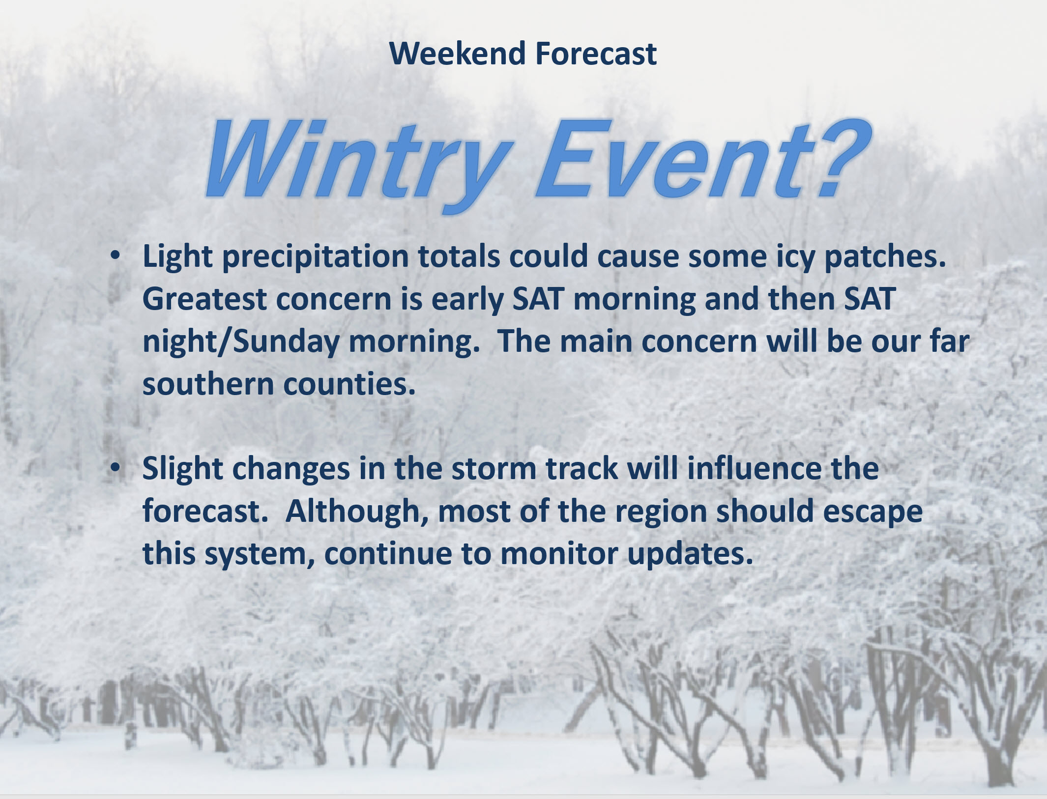
Saturday forecast: Mostly cloudy. Cold. A chance of a wintry mix changing along the MO/AR and KY/TN State line. Temperatures may rise enough to change everything over to plain rain for a period of time. Monitor updates concerning this topic. Any shift in the storm track would change the going forecast. Use care during the AM hours. Remember, bridges freeze first.
My confidence in the forecast verifying: Medium (50% confidence)
Temperature range: MO ~ 32 to 34 IL ~32 to 34 KY ~ 32 to 34 TN ~ 32 to 34
Wind chill (feels like) temperature forecast: 15 to 25
What is the chance/probability of precipitation? MO ~ 50% (near Poplar Bluff and 10% near Farmington, MO IL ~ 20% KY ~ 10% near Owensboro to 60% near Fulton, KY (far southwest part of KY) TN ~ 70%
Coverage of precipitation: None for most of us to numerous near the Bootheel into western Tennessee.
Is flooding anticipated? No
Is accumulating snow or ice anticipated? Yes. There is the potential of freezing rain, sleet, and snow during the AM hours. It could change to rain during the PM hours.
Is non-accumulating snow or ice anticipated?
Are icy road conditions anticipated? At this time, the greater concerns appear to be Saturday PM into Sunday. Monitor updates.
Wind direction and speed: North and northeast at 10 to 20 mph
What impacts are anticipated from the weather? Scattered wet roadways. Scattered icy roads possible near Poplar Bluff, Missouri and then east into the Bootheel and west Tennessee Monitor the KY/TN border counties.
Is severe weather expected? No
The NWS officially defines severe weather as 58 mph wind or great, 1″ hail or larger, and/or tornadoes
Will lightning be possible? No
Should I cancel my outdoor plans? For most of us, no. For areas along the MO/AR and KY/TN border you should monitor radars and updates.
Will the weather impact my outdoor plans? For most of the area, no. The above-mentioned areas should monitor radars.
UV Index: 1 to 2 Low
Sunrise: 6:57 AM
ANY shift in this storm systems track will completely change our local forecast. Monitor updates.
Saturday Night Forecast Details:
Forecast: A chance of rain or ice/snow changing to freezing rain, sleet, and snow along the MO/AR and KY/TN border southward. Some icy roads possible. Temperatures may be marginal for icy roads and this needs to be monitored.
My confidence in the forecast verifying: Medium (40% confidence)
Temperature range: MO ~ 25 to 30 IL ~ 25 to 30 KY ~ 25 to 30 TN ~ 26 to 30
Wind chill (feels like) temperature forecast: 10 to 20
What is the chance/probability of precipitation? MO ~ 70% near the MO/AR state line to 30% near Farmington, MO IL ~ 30% KY ~ 20% along the KY/IN State line to 60% along the KY/TN State line TN ~ 80%
Coverage of precipitation: None north to perhaps widespread far southern counties in the region.
Is flooding anticipated? No
Is accumulating snow or ice anticipated? Yes. That will be a possibility along the MO/AR and KY/TN State line.
Is non-accumulating snow or ice anticipated?
Are icy road conditions anticipated? Yes. Icy roads are possible.
Wind direction and speed: Northeast at 8 to 16 mph with gusts to 30 mph
What impacts are anticipated from the weather? Wet roadways. Icy roadways.
Is severe weather expected? No
The NWS officially defines severe weather as 58 mph wind or great, 1″ hail or larger, and/or tornadoes
Will lightning be possible? No
Should I cancel my outdoor plans? Have a plan B along the MO/AR and KY/TN State line. Monitor updates.
Will the weather impact my outdoor plans? Yes. Precipitation could cause problems with travel in the area with wintry precipitation.
Sunset: 4:37 PM
Moonrise: 7:58 AM Waxing Crescent
Moonset: 6:00 PM
December 9, 2018
Sunday forecast: Cloudy. Dry for most of the region. A chance of a wintry mix changing to all rain from the Bootheel eastward along the KY/TN State line. Temperatures should rise above freezing. Any icy road travel concerns would then subside.
My confidence in the forecast verifying: LOW (30% confidence)
Temperature range: MO ~ 36 to 40 IL ~ 35 to 40 KY ~ 36 to 40 TN ~ 34 to 38
Wind chill (feels like) temperature forecast: 25 to 35
What is the chance/probability of precipitation? MO ~ 30% IL ~ 20% KY ~ 40% mainly along the KY/TN border and perhaps our southeast counties near Hopkinsville TN ~ 80%
Coverage of precipitation: Most of the area may remain dry. Areas from the Bootheel and then east along the KY/TN State line will need to be monitored.
Is flooding anticipated? No
Is accumulating snow or ice anticipated? It is possible during the AM hours.
Is non-accumulating snow or ice anticipated?
Are icy road conditions anticipated? Some icy roads are possible from the MO/AR to KY/TN State line southward.
Wind direction and speed: North at 10 to 20 mph
What impacts are anticipated from the weather? Wet and/or icy roads are possible.
Is severe weather expected? No
The NWS officially defines severe weather as 58 mph wind or great, 1″ hail or larger, and/or tornadoes
Will lightning be possible? No
Should I cancel my outdoor plans? No, for most. Areas from the MO/AR to KY/TN State line should monitor updates.
Will the weather impact my outdoor plans? The region could have some icy road conditions. If you have travel plans then monitor regional updates.
UV Index: 3 Medium
Sunrise: 6:58 AM
Sunday Night Forecast Details:
Forecast: Some clouds. Cold. Patchy fog.
My confidence in the forecast verifying: Medium (40% confidence)
Temperature range: MO ~ 24 to 28 IL ~ 22 to 26 KY ~ 24 to 28 TN ~ 24 to 28
Wind chill (feels like) temperature forecast: 10 to 15
What is the chance/probability of precipitation? MO ~ 0% IL ~ 0% KY ~ 20% TN ~ 20%
Coverage of precipitation: Most likely none, but monitor updates. There is a small disturbance near the region.
Is flooding anticipated? No
Is accumulating snow or ice anticipated? Most likely no, but monitor updates.
Is non-accumulating snow or ice anticipated?
Are icy road conditions anticipated? Yes. Some icy roads will be possible in the region.
Wind direction and speed: North at 7 to 14 mph with gusts to 20 mph
What impacts are anticipated from the weather? Monitor road conditions. Icy roads are possible if the winter storm does materialize.
Is severe weather expected? No
The NWS officially defines severe weather as 58 mph wind or great, 1″ hail or larger, and/or tornadoes
Will lightning be possible? No
Should I cancel my outdoor plans? There could still be icy roads remaining in the region. This will be dependent on the track of the weekend winter storm.
Will the weather impact my outdoor plans? Remaining impacts from the winter storm are possible.
Sunset: 4:37 PM
Moonrise: 8:49 AM Waxing Crescent
Moonset: 6:50 PM
December 10, 2018
Monday forecast: Partly cloudy. Cold again.
My confidence in the forecast verifying: Medium (60% confidence)
Temperature range: MO ~ 33 to 36 IL ~33 to 36 KY ~ 30 to 35 TN ~ 32 to 36
Wind chill (feels like) temperature forecast: 20 to 30
What is the chance/probability of precipitation? MO ~ 0% IL ~ 0% KY ~ 0% TN ~ 0%
Coverage of precipitation: None
Is flooding anticipated? No
Is accumulating snow or ice anticipated? No
Is non-accumulating snow or ice anticipated? No
Are icy road conditions anticipated? Unlikely
Wind direction and speed: North at 10 to 20 mph
What impacts are anticipated from the weather? Monitor morning patchy fog
Is severe weather expected? No
The NWS officially defines severe weather as 58 mph wind or great, 1″ hail or larger, and/or tornadoes
Will lightning be possible? No
Should I cancel my outdoor plans? No
Will the weather impact my outdoor plans? No
UV Index: 3 Medium
Sunrise: 6:58 AM
Monday Night Forecast Details:
Forecast: Mostly clear and cold.
My confidence in the forecast verifying: Medium (60% confidence)
Temperature range: MO ~ 20 to 25 IL ~ 20 to 25 KY ~ 18 to 24 TN ~ 18 to 24
Wind chill (feels like) temperature forecast: 15 to 20
What is the chance/probability of precipitation? MO ~ 0% IL ~ 0% KY ~ 0% TN ~ 0%
Coverage of precipitation: None
Is flooding anticipated? No
Is accumulating snow or ice anticipated? No
Is non-accumulating snow or ice anticipated? No
Are icy road conditions anticipated? No
Wind direction and speed: North at 7 to 14 mph with gusts to 20 mph
What impacts are anticipated from the weather? None
Is severe weather expected? No
The NWS officially defines severe weather as 58 mph wind or great, 1″ hail or larger, and/or tornadoes
Will lightning be possible? No
Should I cancel my outdoor plans? No
Will the weather impact my outdoor plans? No
Sunset: 4:37 PM
Moonrise: 9:38 AM Waxing Crescent
Moonset: 7:43 PM
December 11, 2018
Tuesday forecast: Mostly sunny. Not quite as cold.
My confidence in the forecast verifying: Medium (50%)
Temperature range: MO ~ 40 to 45 IL ~40 to 45 KY ~ 40 to 45 TN ~ 40 to 45
Wind chill (feels like) temperature forecast: 35 to 45
What is the chance/probability of precipitation? MO ~ 0% IL ~ 0% KY ~ 0% TN ~ 0%
Coverage of precipitation: None
Is flooding anticipated? No
Is accumulating snow or ice anticipated? No
Is non-accumulating snow or ice anticipated? No
Are icy road conditions anticipated? No
Wind direction and speed: South at 5 to 10 mph
What impacts are anticipated from the weather? No
Is severe weather expected? No
The NWS officially defines severe weather as 58 mph wind or great, 1″ hail or larger, and/or tornadoes
Will lightning be possible? No
Should I cancel my outdoor plans? No
Will the weather impact my outdoor plans? No
UV Index: 2 Low
Sunrise: 6:59 AM
Tuesday Night Forecast Details:
Forecast: Mostly clear and cold. Some fog possible. Temperatures will be highly dependent on what happens over the weekend. More snow and it will be colder.
My confidence in the forecast verifying: Medium (50%)
Temperature range: MO ~ 24 to 28 IL ~ 24 to 28 KY ~ 24 to 28 TN ~ 24 to 28
Wind chill (feels like) temperature forecast: 15 to 20
What is the chance/probability of precipitation? MO ~ 0% IL ~ 0% KY ~ 0% TN ~ 0%
Coverage of precipitation: None
Is flooding anticipated? No
Is accumulating snow or ice anticipated? No
Is non-accumulating snow or ice anticipated? No
Are icy road conditions anticipated? No
Wind direction and speed: East at 5 to 10 mph
What impacts are anticipated from the weather? None
Is severe weather expected? No
The NWS officially defines severe weather as 58 mph wind or great, 1″ hail or larger, and/or tornadoes
Will lightning be possible? No
Should I cancel my outdoor plans? No
Will the weather impact my outdoor plans? No
Sunset: 4:37 PM
Moonrise: 10:19 AM Waxing Crescent
Moonset: 8:37 PM
December 12, 2018
Wednesday forecast: Increasing clouds.
My confidence in the forecast verifying: Medium (50%)
Temperature range: MO ~ 40 to 45 IL ~40 to 45 KY ~ 40 to 45 TN ~ 40 to 45
Wind chill (feels like) temperature forecast:
What is the chance/probability of precipitation? MO ~ 10% IL ~ 10% KY ~ 10% TN ~ 10%
Coverage of precipitation: None
Is flooding anticipated? No
Is accumulating snow or ice anticipated? No
Is non-accumulating snow or ice anticipated? No
Are icy road conditions anticipated? Most likely no
Wind direction and speed: Southeast at 5 to 10 mph
What impacts are anticipated from the weather?
Is severe weather expected? No
The NWS officially defines severe weather as 58 mph wind or great, 1″ hail or larger, and/or tornadoes
Will lightning be possible? No
Should I cancel my outdoor plans? No, but monitor updates
Will the weather impact my outdoor plans? Monitor updates
UV Index: 3 Medium
Sunrise: 7:00 AM
Wednesday Night Forecast Details:
Forecast: Cloudy. A rain shower possible.
My confidence in the forecast verifying: Medium (50%)
Temperature range: MO ~ 35 to 40 IL ~ 35 to 40 KY ~ 35 to 40 TN ~ 35 to 40
Wind chill (feels like) temperature forecast:
What is the chance/probability of precipitation? MO ~ 20% IL ~ 20% KY ~ 20% TN ~ 20%
Coverage of precipitation: Scattered
Is flooding anticipated? No
Is accumulating snow or ice anticipated? No
Is non-accumulating snow or ice anticipated? No
Are icy road conditions anticipated?
Wind direction and speed:
What impacts are anticipated from the weather? Wet roadways.
Is severe weather expected? No
The NWS officially defines severe weather as 58 mph wind or great, 1″ hail or larger, and/or tornadoes
Will lightning be possible? No
Should I cancel my outdoor plans? No, but monitor updates
Will the weather impact my outdoor plans? Monitor updates
Sunset: 4:37 PM
Moonrise: 10:57 AM Waxing Crescent
Moonset: 9:33 PM
I am monitoring next Thursday, Friday, and Saturday’s system.
Learn more about the UV index readings. Click here.
Wind forecast
Click to enlarge
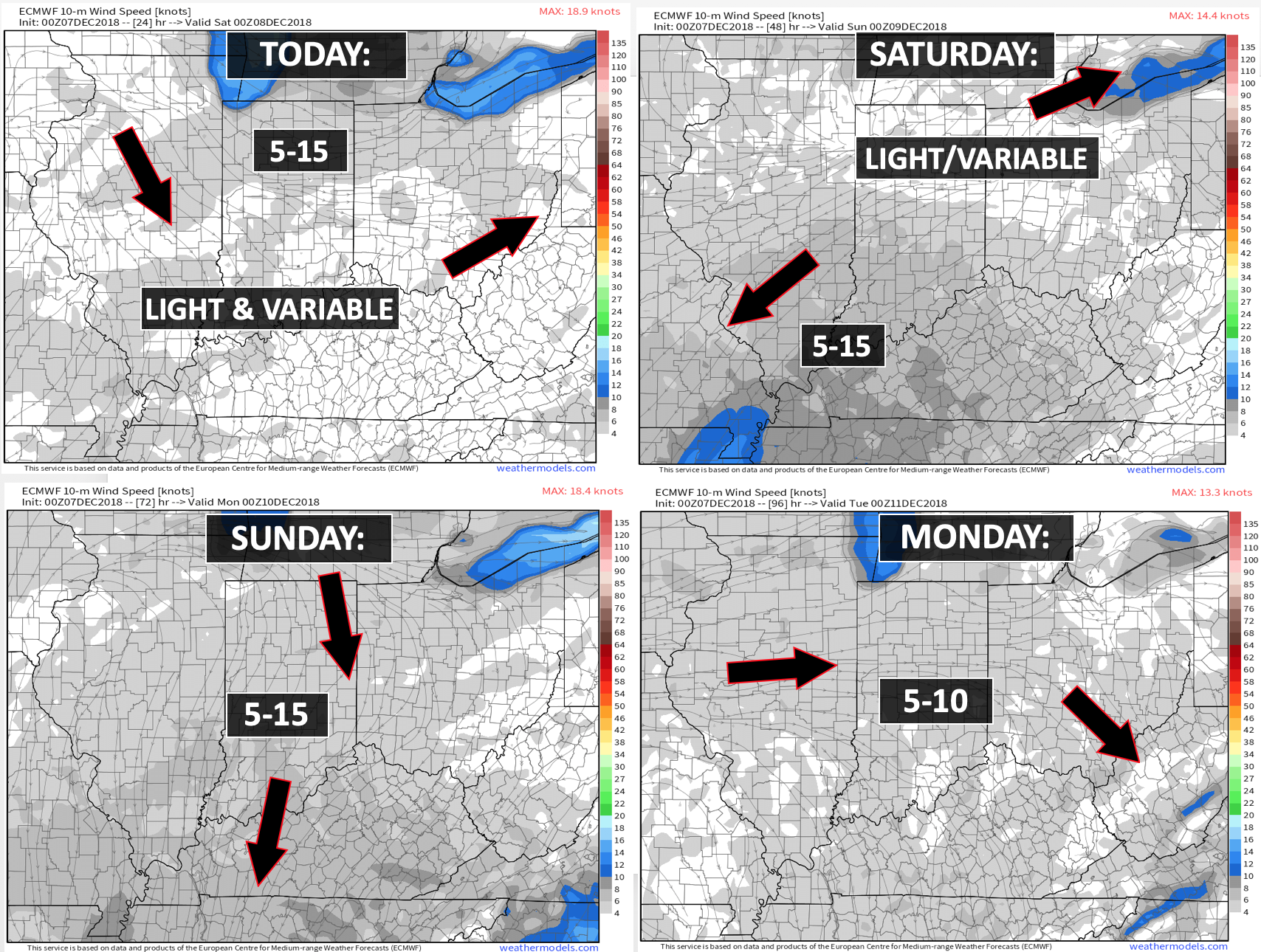

Today through Monday: ANY shift in this storm systems track will completely change our local forecast. Monitor updates.
A winter storm is sweeping across parts of the central and southern United States. This system may clip our region with a wintry mix. The main concern will be late tonight into Saturday morning and then Saturday night into Sunday morning.
Areas along the MO/AR border eastward into the Missouri Bootheel and then along the KY/TN border southward will need to monitor radars and updates. ANY shift in the storm track will change the forecast.
If it shifts a bit further south then we would all miss out on wintry precipitation. Tough forecast in the above mentioned areas.
Temperatures will be cold enough tonight for some icy roads (if precip falls). Temperatures may rise to or above freezing on Saturday afternoon. Temperatures would then fall again Saturday night into Sunday morning before rising again Sunday afternoon.
Temperatures will obviously control what type of precipitation falls.
If you have travel plans in the region then monitor the latest forecast updates.
The rest of the region should remain ice free.
Next week: I am closely monitor late next week. Another system could bring wintry weather to the region. Still early for details.

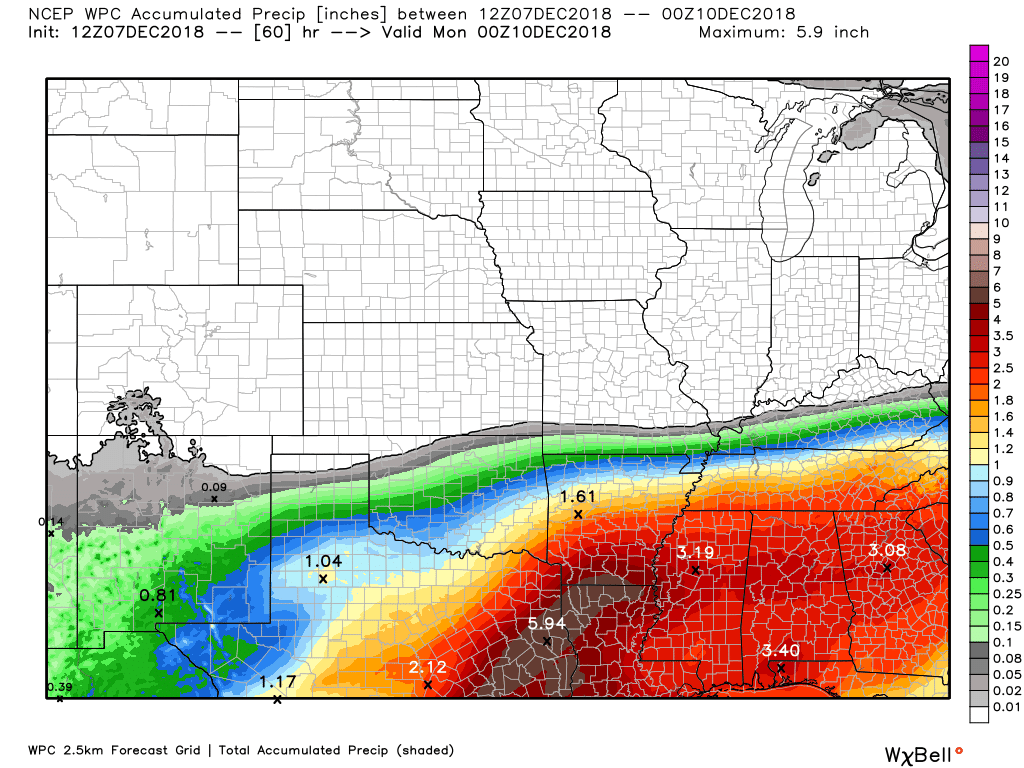
Here is the WPC/NOAA rainfall outlook
This is liquid totals. That means melted. That would include all forms.
Click to enlarge.
WPC is pretty far north with these totals. It is a close call forecast for some of us. Southern counties should pay attention to forecast adjustments.
ANY shift in this storm systems track will completely change our local forecast. Monitor updates.
Did you know that you can find me on Twitter?

Subscribers, do you need a forecast for an outdoor event?


We offer interactive local city live radars and regional radars.
If a radar does not update then try another one. If a radar does not appear to be refreshing then hit Ctrl F5 on your keyboard.
You may also try restarting your browser. The local city view radars also have clickable warnings.
During the winter months, you can track snow and ice by clicking the winterize button on the local city view interactive radars.

Questions? Broken links? Other questions?
You may email me at beaudodson@usawx.com

The National Weather Service defines a severe thunderstorm as one that produces quarter size hail or larger, 58 mph winds or greater, and/or a tornado.
Thursday through next Wednesday: No severe weather.
Interactive live weather radar page. Choose the city nearest your location. If one of the cities does not work then try a nearby one. Click here.
National map of weather watches and warnings. Click here.
Storm Prediction Center. Click here.
Weather Prediction Center. Click here.

Live lightning data: Click here.

Interactive GOES R satellite. Track clouds. Click here.

Here are the latest local river stage forecast numbers Click Here.
Here are the latest lake stage forecast numbers for Kentucky Lake and Lake Barkley Click Here.

- A cold front moves through the region today with showers. Some snow showers possible.
- Colder tonight and Friday.
- Winter storm this weekend.
- Another system towards the middle/end of next week.
ANY shift in this storm systems track will completely change our local forecast. Monitor updates.
No major adjustments to yesterday’s forecast.
This still appears to be a southern event.
Any shift further south and it would even miss my southern counties.
Continue to monitor updates.
I did slightly adjust the probability maps.
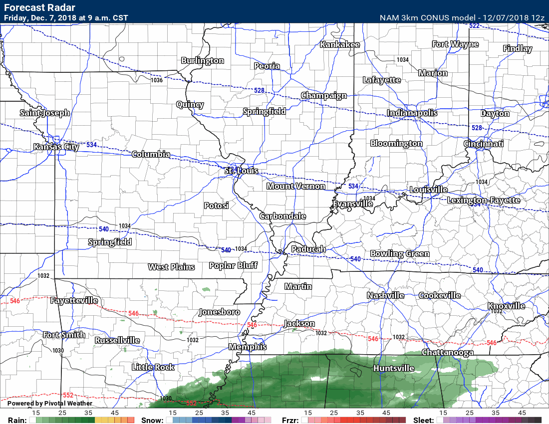
Let’s look at some future-cast radar images from the different models.
Remember, how I have been saying to ignore the amounts and focus on the track. The models have done well with the forecast track. They have been staying within one to three counties distance between each run. That is pretty good for models. There have not been any wild shifts in the track forecast. There were wild shifts in the amounts. That is why I kept saying to ignore the snow and ice totals. Models do poorly with that part of the forecast.
There has been a slight southward shift in most of the guidance. Perhaps a county or two further south. Of course, this does have major impacts on our regions forecast. As I have been saying over the past week, any shift south or north would completely change our forecast. That continues to be my thinking.
There remain questions about the northern edge of the precipitation. It is close.
Here is the NAM future-cast radar.
Green is rain. Blue is snow. Orange/pink is a wintry mix.
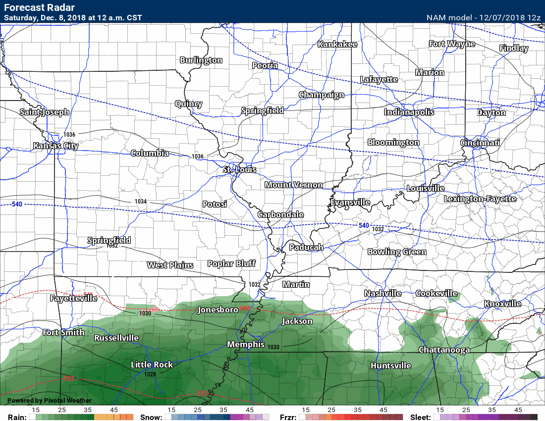
Here is the 3K higher resolution NAM model guidance future-cast radar. Notice it is further north than the lower resolution NAM. There are two versions of that model.
It is close for my southern forecast counties. We will have to monitor radars. We are only talking a county or two difference (but that makes a lot of different for those who live in my forecast zone).
Remember, I forecast for the Bootheel and west TN, as well.
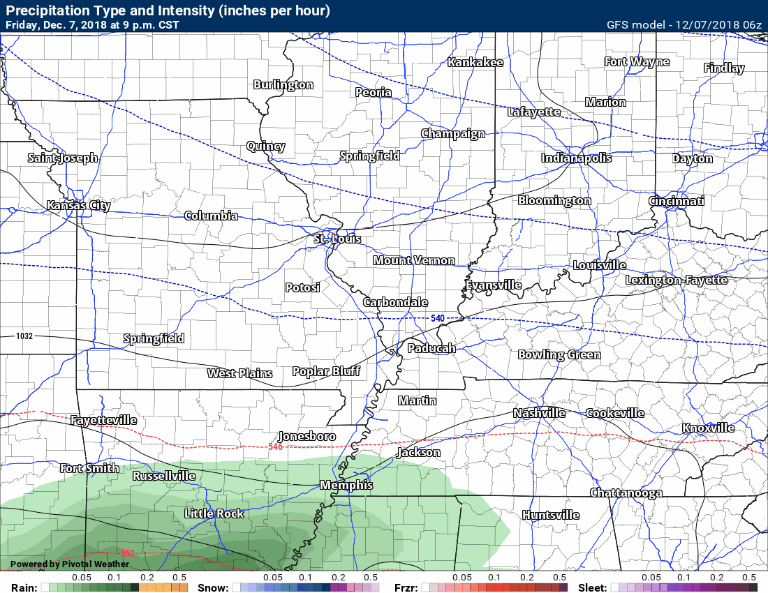
Here is the GFS model.
The GFS barely nicks our region. Not as far north as the higher res models.
ANy shift would cause forecast changes.
It could miss us to the south.
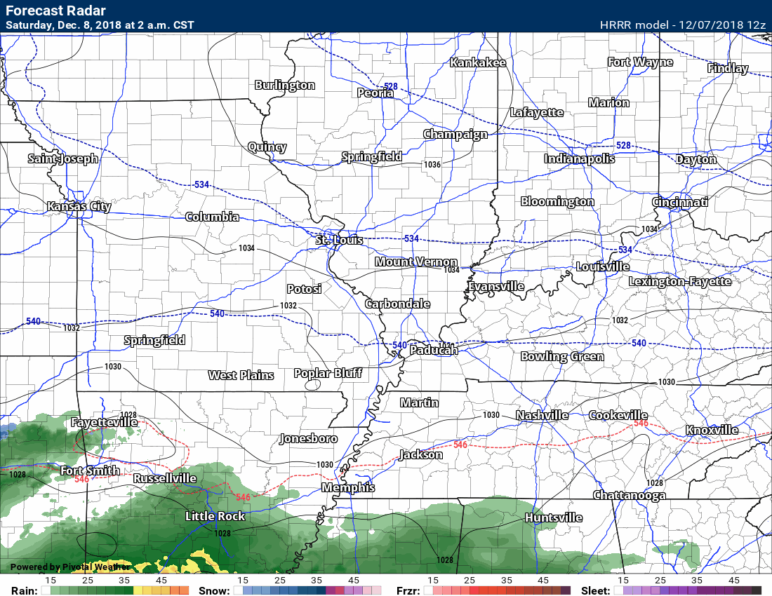
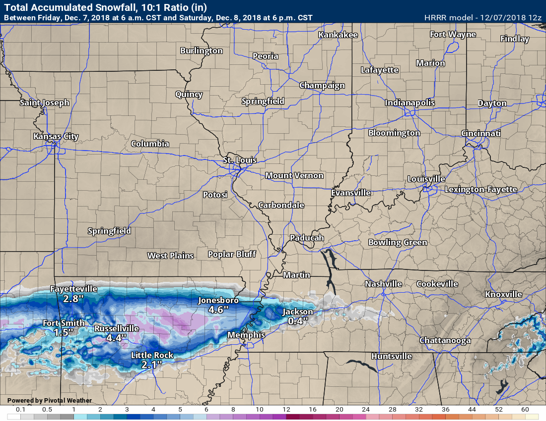
Finally, let’s look at the Hrrr model guidance.
Close! It nicks our region, as well.
It seems the MO/AR and KY/TN border counties will be the area to watch.
It will be a close call forecast for those areas. Remember, it only takes a hint of ice to cause travel headaches.
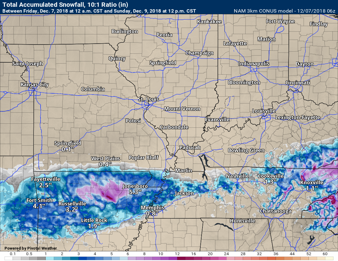
Just how much snow and ice do the Hrrr mode, GFS mode, and NAM model show?
ANY shift in this storm systems track will completely change our local forecast. Monitor updates.
Here is the NAM 3K model. It indicates areas along the MO/AR and KY/TN state line southward should monitor updates.
I would not get too caught up in the numbers. Focus more on the path track. Those will be areas of concern.
The models don’t handle snow or ice numbers all that great. Thus, I keep telling everyone to ignore those numbers.
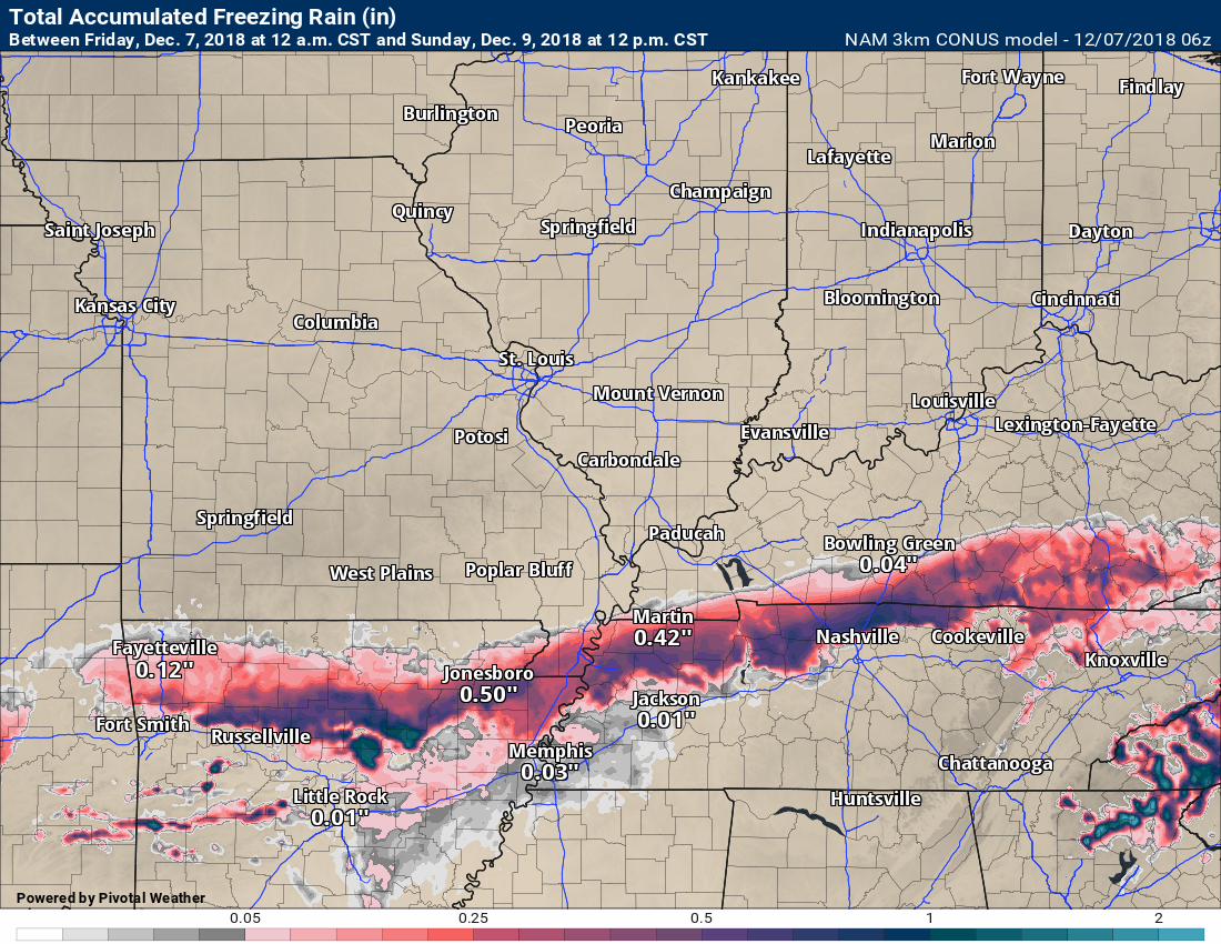
This is the NAM freezing rain forecast. You can cut this in half. The model isn’t forecasting accretion. It is forecasting how much liquid falls. Normally if this shows 0.25″ of freezing rain you can expect 0.05″ to 0.15″ give or take.
There could be some ice.
This nicks my southern counties. Again, any change in storm track would change the forecast. Slight changes would make a big difference for some.
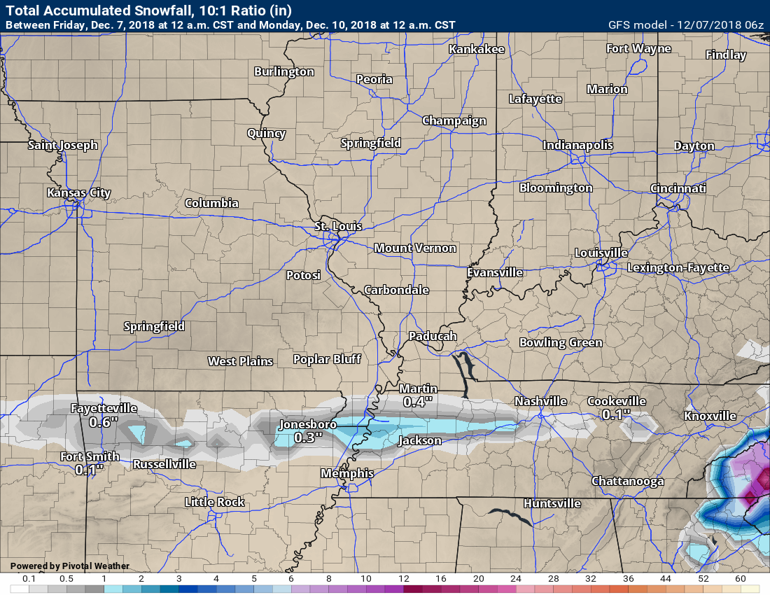
The GFS model shows very little in the way of accumulating snow and ice.
The Hrrr model.
The Hrrr model agrees with the NAM 3K in placement.
Again, ignore the totals and focus on the track.
Here are my forecast thoughts on probabilities.
I made slight adjustments to about half the graphics. Everything else looks the same. No major adjustments one way or another for most of us.
This continues to be a southern system.
ANY shift in this storm systems track will completely change our local forecast. Monitor updates.
I am monitoring December 18th through the 22nd for a precipitation system, as well.
![]()
Bonus VIDEO UPDATES
These are bonus videos and maps for subscribers. I bring these to you from the BAMwx team. I pay them to help with videos.
The Ohio and Missouri Valley videos cover most of our area. They do not have a specific Tennessee Valley forecast but may add one in the future.
The long-range video is technical. Over time, you can learn a lot about meteorology from the long range video. Just keep in mind, it is a bit more technical.
NOTE: THESE ARE USUALLY NOT UPDATED ON SATURDAY OR SUNDAY.

Videos will be posted on the www.weathertalk.com website under the video tab. They will be posted between 9:20 am and 9:40 am

Videos will be posted on the www.weathertalk.com website under the video tab. They will be posted between 9:20 am and 9:40 am

This video will be posted on the www.weathertalk.com page around 10 am
![]()

I bring these to you from the BAMwx team. They are excellent long-range forecasters.
Remember, long-range outlooks are always going to be a lower confidence level than short-term forecasts. It is not an exact science. There are many variables that determine the eventual outcome of a long-range forecast.

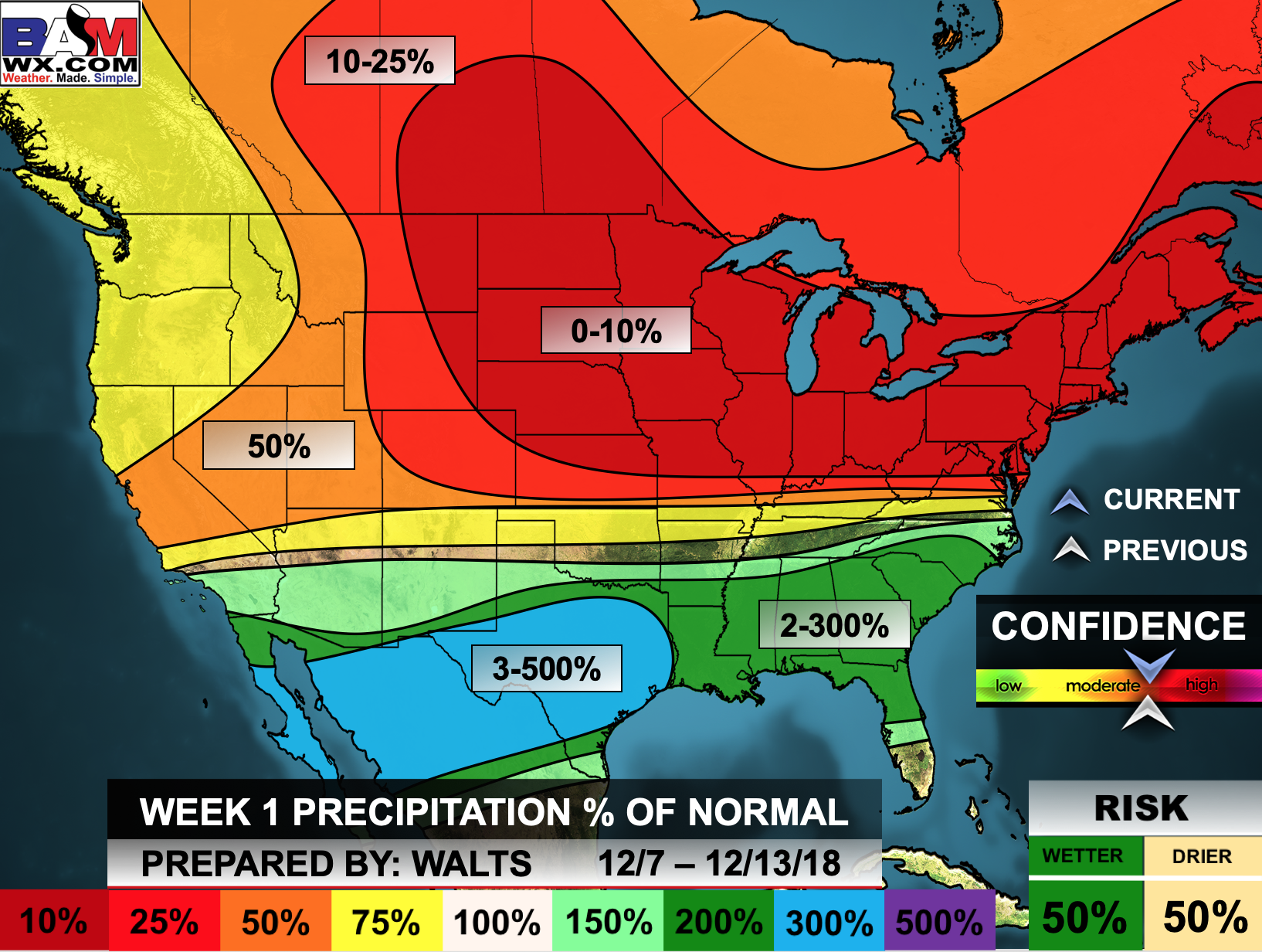
Normal high temperatures for this time of the year are around 50 degrees.
Normal low temperatures for this time of the year are around 30 degrees.
Normal precipitation during this time period ranges from 0.60″ to 0.80″
This outlook covers December 7th through 13th
Click images to enlarge them.
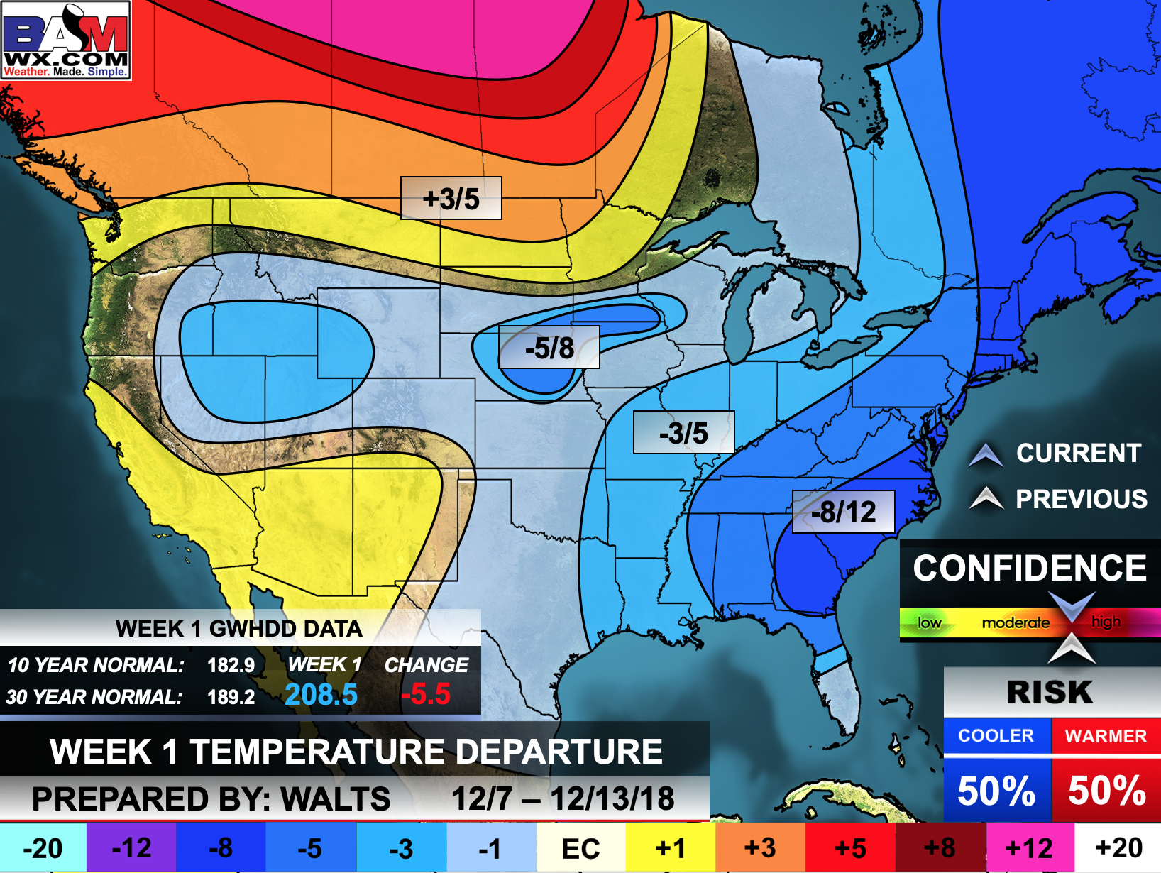
The precipitation forecast is PERCENT OF NORMAL. For example, if your normal rainfall is 1.00″ and the graphic shows 10%, then that would mean 0.10″ of rain is anticipated.

Normal high temperatures for this time of the year are around 47 degrees
Normal low temperatures for this time of the year are around 29 degrees
Normal precipitation during this time period ranges from 0.65″ to 0.90″
This outlook covers December 13th through December 19th
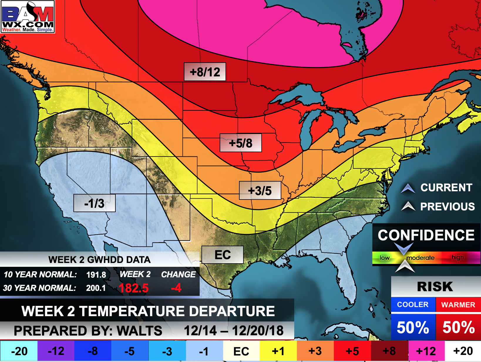
The precipitation forecast is PERCENT OF NORMAL. For example, if your normal rainfall is 1.00″ and the graphic shows 10%, then that would mean 0.10″ of rain is anticipated.
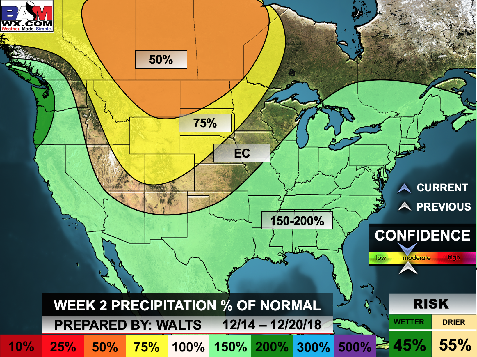

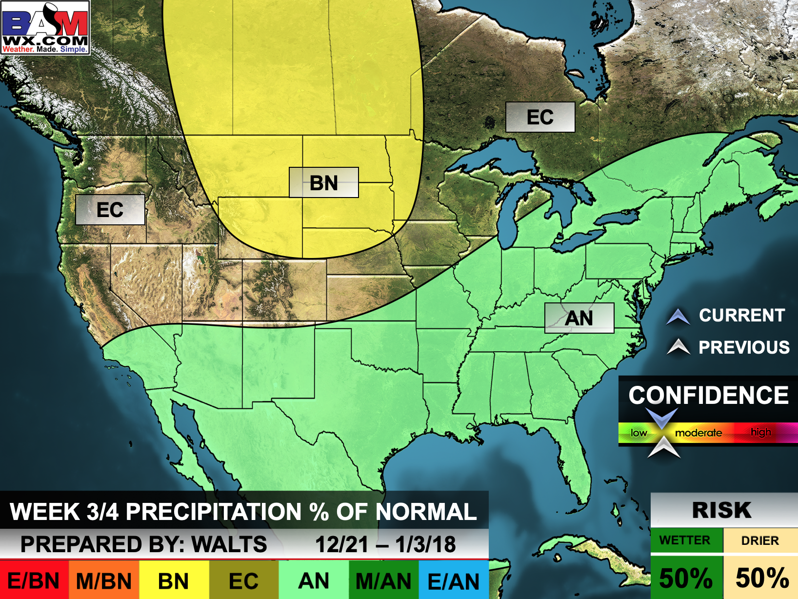
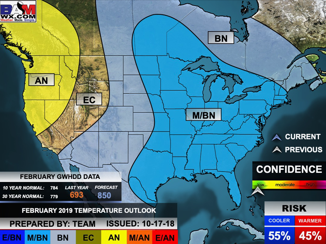
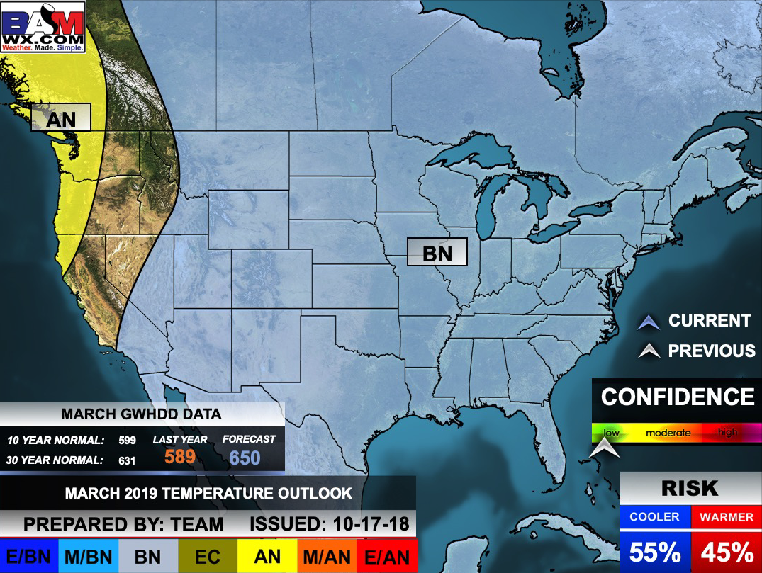
Outlook definitions
EC = Equal chances of above or below normal
BN= Below normal
M/BN = Much below normal
AN = Above normal
M/AN = Much above normal
E/AN = Extremely above normal
Normal high temperatures for this time of the year are around 43 degrees
Normal low temperatures for this time of the year are around 24 degrees
Normal precipitation during this time period ranges from 1.50″ to 2.20″
This outlook covers December 21st through January 3rd
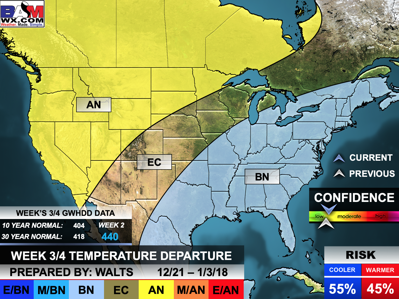
The precipitation forecast is PERCENT OF NORMAL. For example, if your normal rainfall is 1.00″ and the graphic shows 10%, then that would mean 0.10″ of rain is anticipated.
![]()

The winter update has been posted.
I always tell people to read this
http://johndee.com/seasonalfcst/soapbox.htm
Winter forecasts are some skill and some luck. The science is far from perfect.
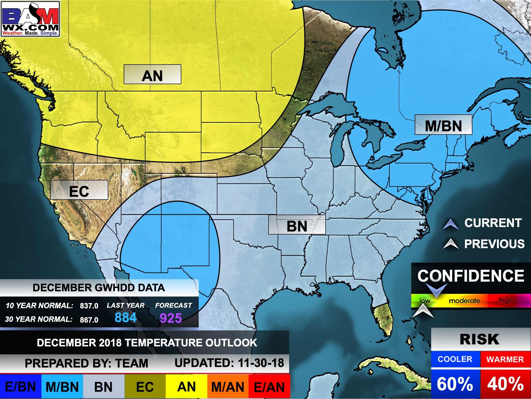
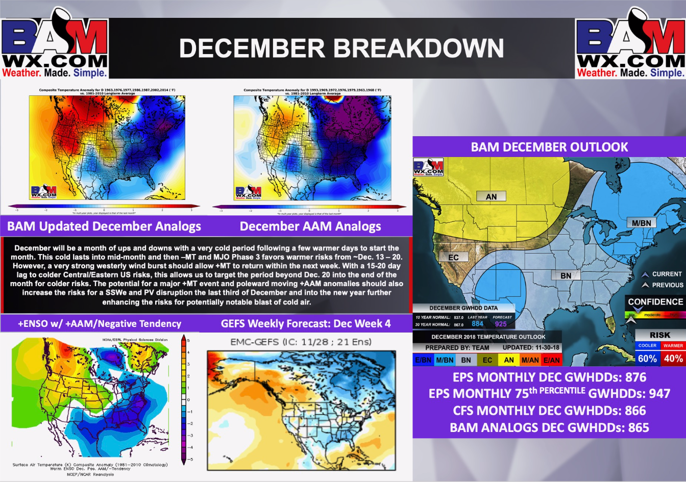
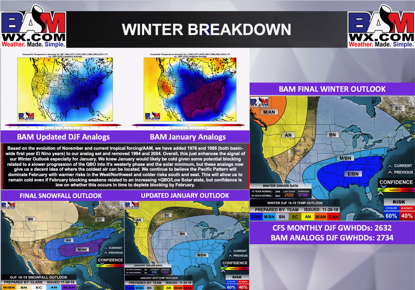
First, here are updated December and January temperature outlook graphics
December temperature outlook
January temperature outlook

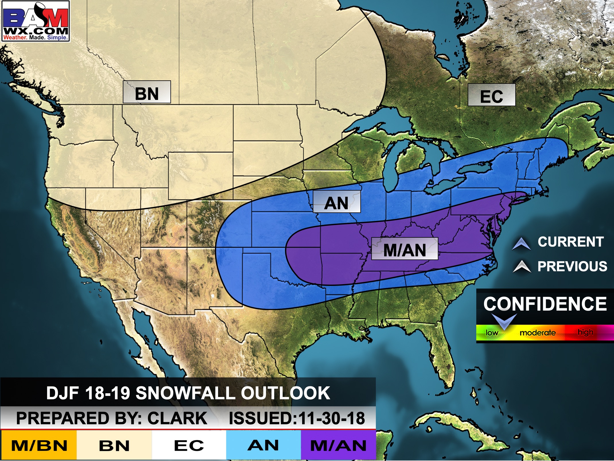
December through February snow outlook.
The long range team indicates above normal snowfall likely.
Technical details
Click to enlarge
Click to enlarge
Winter long-range video update
![]()
January temperature outlook
February temperature outlook
March Temperature Outlook
![]()

A new weather podcast is now available! Weather Geeks (which you might remember is on The Weather Channel each Sunday)
To learn more visit their website. Click here.
![]()

WeatherBrains Episode 672
Tonight’s Guest WeatherBrain is the Branch Chief at NOAA’s Earth System Research Laboratory. He has his PhD from the University of Oklahoma. Curtis Alexander, welcome to WeatherBrains!
Tonight’s second Guest WeatherBrain is also a researcher at the Earth System Research Laboratory. He has his PhD from Penn State University. Stephen Weygandt, welcome to the show!
Other discussions in this weekly podcast include topics like:
- How weather models have changed over the years
- National weather round-up
- Astronomy Outlook with Tony Rice
- and more!
Link to their website https://weatherbrains.com/
Previous episodes can be viewed by clicking here.
We offer interactive local city live radars and regional radars. If a radar does not update then try another one. If a radar does not appear to be refreshing then hit Ctrl F5. You may also try restarting your browser.
The local city view radars also have clickable warnings.
During the winter months, you can track snow and ice by clicking the winterize button on the local city view interactive radars.
You may email me at beaudodson@usawx.com
Find me on Facebook!

Find me on Twitter!

Did you know that a portion of your monthly subscription helps support local charity projects?
You can learn more about those projects by visiting the Shadow Angel Foundation website and the Beau Dodson News website.

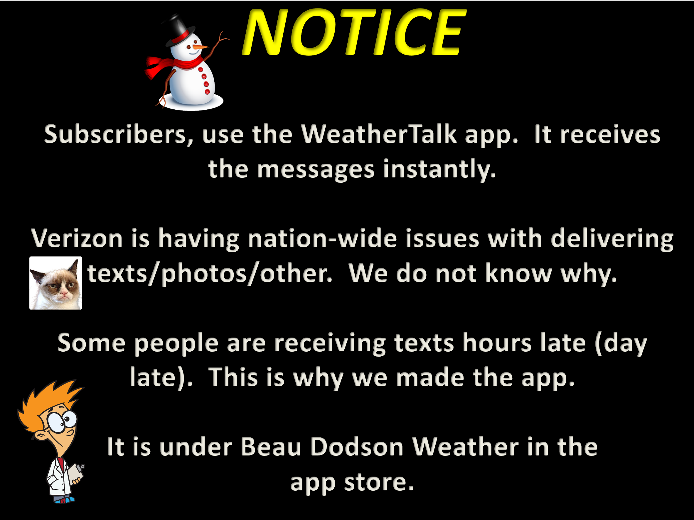
I encourage subscribers to use the app vs regular text messaging. We have found text messaging to be delayed during severe weather. The app typically will receive the messages instantly. I recommend people have three to four methods of receiving their severe weather information.
Remember, my app and text alerts are hand typed and not computer generated. You are being given personal attention during significant weather events.
