December 7, 2017
I posted the daily forecast at the bottom of this update.
LONG RANGE VIDEOS AND GRAPHICS have been posted for subscribers on Weather Talk.
You can view those from this link Weather Talk Videos and Long Range Graphics
If you are not a subscriber then please visit www.beaudodsonweather.com and sign up!
Subscribers receive a lot more information.
.
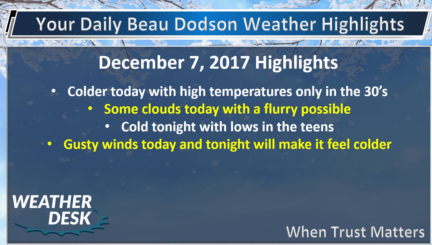
Brrr
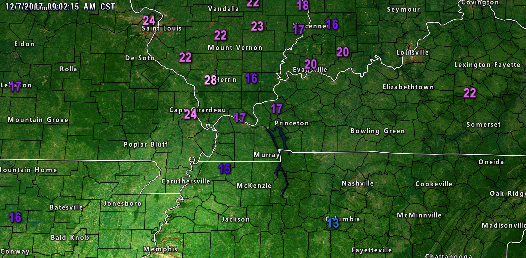
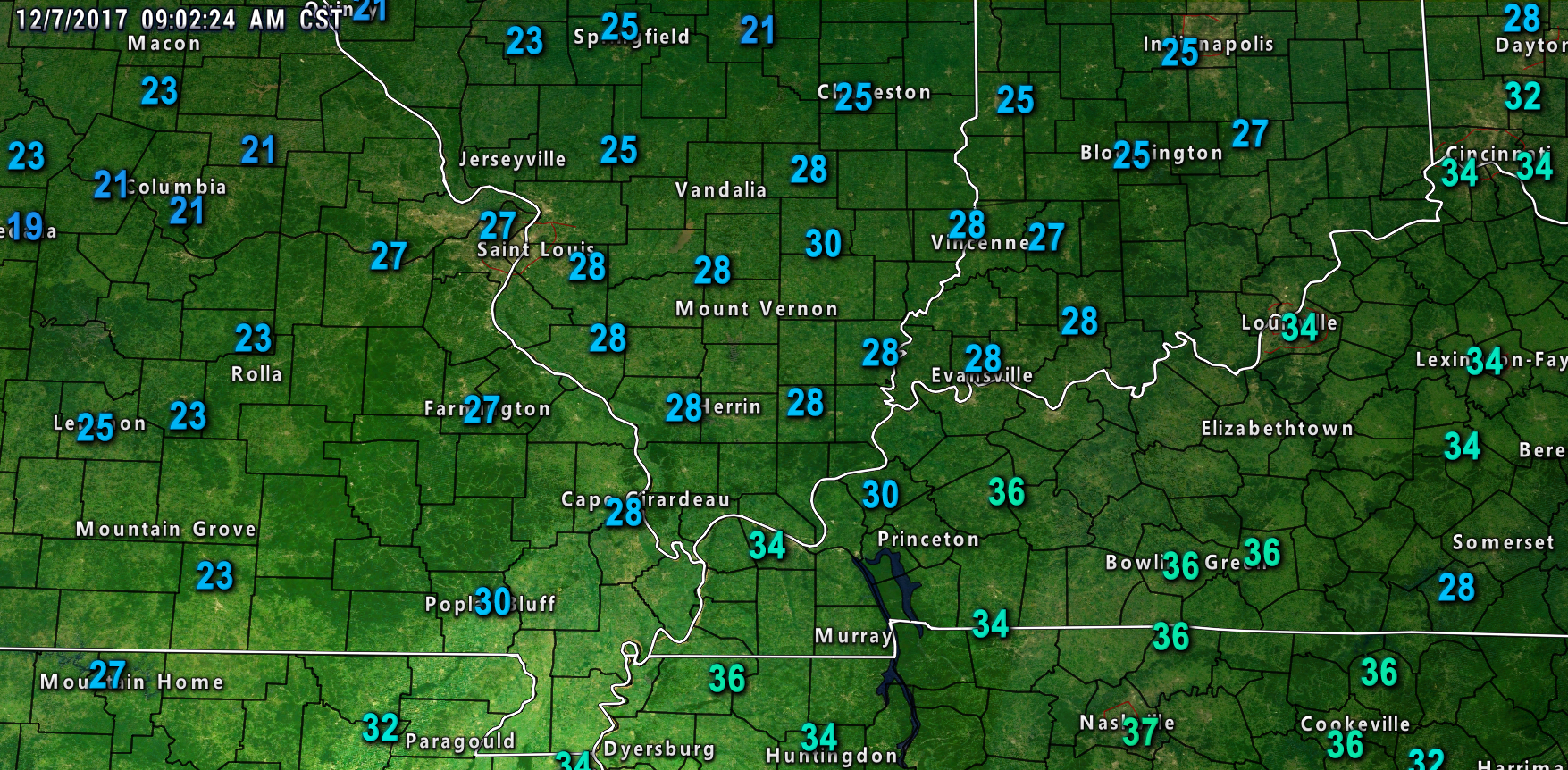
It has been a chilly morning with gusty winds. Lows last night dipped into the lower to middle 20’s over a large portion of the area. Some areas were in the upper 20’s. Either way, it was chilly.
Here was the 9 AM snapshot of wind gusts and temperatures.
.
.
.
.
A cold front is moving through the area today. This front will reinforce the cold air.
Temperatures will be well below normal today into Saturday. Highs will only reach into the 30’s today and Friday.
Wind chills today and tonight will dip into the teens.
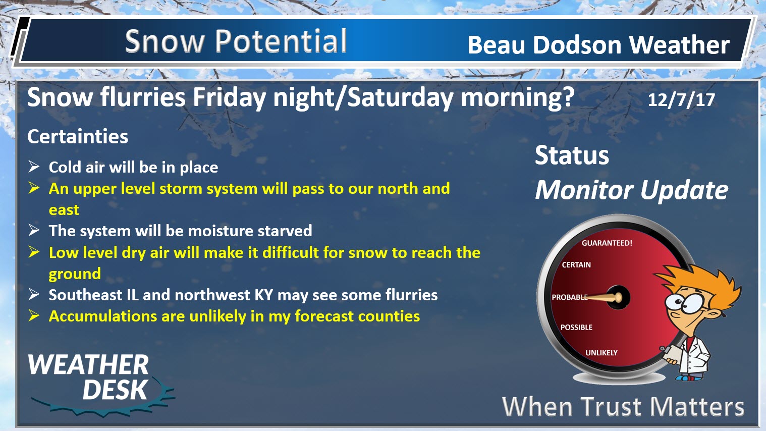
Today’s front is moisture starved. I can’t rule out some snow flurries, but nothing significant. Just a reminder that it is cold.
There will be some clouds today, as well.
Friday into Sunday
Friday will be cold with quite a bit of sunshine. Clouds may increase as we move into the afternoon hours. Again, highs will mainly be in the 30’s. Any wind will make it feel colder.
A disturbance will pass near our region on Friday night and Saturday morning, but it will be moisture starved, as well.
Light snow showers or flurries will be possible Friday night and Saturday morning over southeast Illinois and northwest Kentucky. Elsewhere, snow is less likely.
Either way, significant snow accumulation is not anticipated. The brunt of that system will be to our northeast.
Saturday afternoon into Sunday will be dry with below normal temperatures.
Highs on Saturday will be in the 36 to 44 degree range and highs on Sunday will likely be in the lower to middle 40’s.
Monday through Thursday of next week
A series of storm systems will push into our region from the northwest next week.
A couple of cold fronts, as well.
Each of these systems could produce light rain and snow. At this time, it is too early to know if snow accumulation will be on the table. Monitor updates.
Monday should be dry during the day with highs in the upper 40’s to lower 50’s. That will be near normal in the temperature department.
Clouds increase Monday night and Tuesday. This is when the first disturbance moves through the area. Some light precipitation will be possible. Perhaps a rain/snow mix changing to light snow. Again, too early for specifics.
It does appear to be a fast moving system and moisture is not all that impressive. At least that is how it appears, for now.
Temperatures will likely remain cool to cold for most of next week.
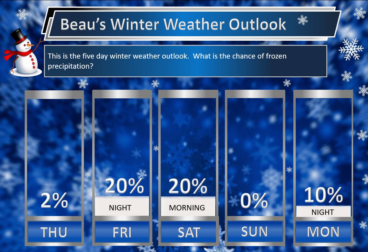
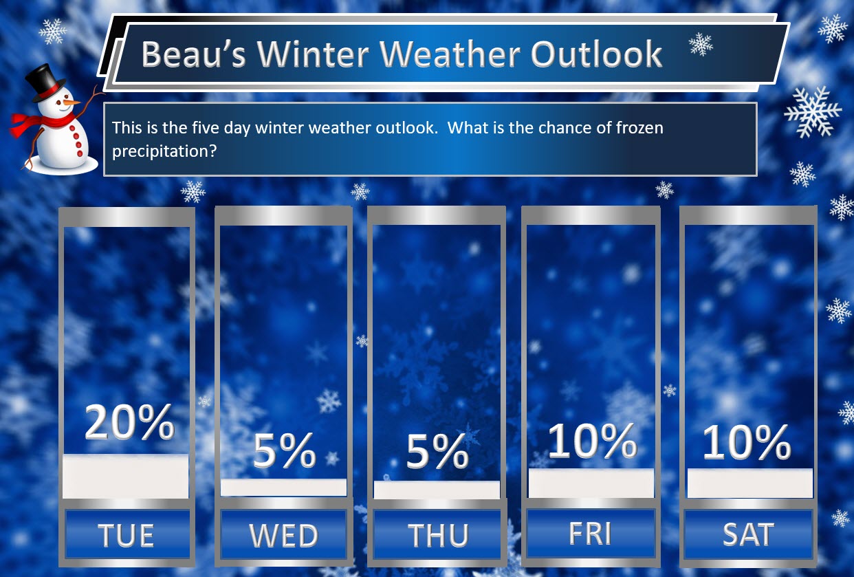
Beau’s Winter Weather Outlook
.
.
Here are my latest snow probability maps. These graphics have nothing to do with accumulation. This is simply the forecast probability of snow falling.
Accumulating snow appears unlikely through Monday afternoon.
Light snow showers or flurries possible Friday night and Saturday. A series of weak disturbances next week could mean sporadic snow showers.
.
.
.
Daily Outlook
December 7, 2017
Thursday Night Forecast Details:
Forecast: Mostly clear. Colder.
Temperatures: MO ~ 16 to 22 IL ~ 15 to 20 KY ~ 16 to 22
Wind chill values: 10 to 16
Accumulating snow or ice: No
Winds: North and northwest winds at 0 to 5 mph
What impacts are anticipated from the weather? None
My confidence in the forecast verifying: High
Is severe weather expected? No
The NWS defines severe weather as 58 mph wind or great, 1″ hail or larger, and/or tornadoes
Is freezing rain, sleet, or snow expected? No
What is the chance of precipitation? MO ~ 0% IL ~ 0% KY ~ 0%
Coverage of precipitation: None
Should I cancel my outdoor plans: No
.
December 8, 2017
Friday Forecast Details
Forecast: Mostly sunny during the morning. Some afternoon clouds possible.
Temperatures: MO ~ 36 to 42 IL ~ 36 to 42 KY ~ 38 to 42
Wind chill values: 20 to 30
Accumulating snow or ice: No
Winds: West and southwest winds at 4 to 8 mph during the morning increasing to 7 to 14 mph in the afternoon
What impacts are anticipated from the weather? None
My confidence in the forecast verifying: High
Is severe weather expected? No
The NWS defines severe weather as 58 mph wind or great, 1″ hail or larger, and/or tornadoes
Is freezing rain, sleet, or snow expected? Snow showers are possible
What is the chance of precipitation? MO ~ 0% IL ~ 0% KY ~ 0%
Coverage of precipitation: Most likely none
Should I cancel my outdoor plans? No
.
Friday Night Forecast Details:
Forecast: Partly cloudy. Breezy and cold. Snow flurries or snow showers possible over southeast Illinois and northwest Kentucky. Cold.
Temperatures: MO ~ 23 to 26 IL ~ 23 to 26 KY ~ 23 to 26
Wind chill values: 10 to 20 degrees
Accumulating snow or ice: Unlikely. Small chance over SE IL and NW KY
Winds: Southwest to west winds 10 to 20 mph. Gusty winds.
What impacts are anticipated from the weather? Most likely none
My confidence in the forecast verifying: High
Is severe weather expected? No
The NWS defines severe weather as 58 mph wind or great, 1″ hail or larger, and/or tornadoes
Is freezing rain, sleet, or snow expected? Snow showers are possible
What is the chance of precipitation? MO ~ 10% IL ~ 30% KY ~ 30%
Coverage of precipitation: Perhaps some scattered snow flurries or snow showers over SE IL and NW KY
Should I cancel my outdoor plans: No
.
December 9, 2017
Saturday Forecast Details
Forecast: Partly cloudy. Snow flurries or snow showers possible (mainly over southeast Illinois and northwest Kentucky). Cold.
Temperatures: MO ~ 35 to 40 IL ~ 35 to 40 KY ~ 35 to 40
Wind chill values: 15 to 24
Accumulating snow or ice: Small chance over SE IL and NW KY
Winds: Northwest winds at 6 to 12 mph with gusts to 20 mph
What impacts are anticipated from the weather? Most likely none
My confidence in the forecast verifying: Medium
Is severe weather expected? No
The NWS defines severe weather as 58 mph wind or great, 1″ hail or larger, and/or tornadoes
Is freezing rain, sleet, or snow expected? Snow flurries or snow showers are possible
What is the chance of precipitation? MO ~ 10% IL ~ 30% KY ~ 30%
Coverage of precipitation: Scattered
Should I cancel my outdoor plans? No
.
Saturday Night Forecast Details:
Forecast: Clearing. Cold.
Temperatures: MO ~ 18 to 24 IL ~ 18 to 24 KY ~ 20 to 25
Wind chill values: 12 to 20 degrees
Accumulating snow or ice: No
Winds: North and northwest winds at 6 to 12 mph
What impacts are anticipated from the weather? None
My confidence in the forecast verifying: High
Is severe weather expected? No
The NWS defines severe weather as 58 mph wind or great, 1″ hail or larger, and/or tornadoes
Is freezing rain, sleet, or snow expected? Most likely none
What is the chance of precipitation? MO ~ 0% IL ~ 10% KY ~ 10%
Coverage of precipitation: None
Should I cancel my outdoor plans: No
.
December 10, 2017
Sunday Forecast Details
Forecast: Mostly sunny and cold.
Temperatures: MO ~ 40 to 45 IL ~ 40 to 45 KY ~ 40 to 45
Wind chill values: 30 to 40
Accumulating snow or ice: No
Winds: Variable at 6 to 12 mph
What impacts are anticipated from the weather? None
My confidence in the forecast verifying: High
Is severe weather expected? No
The NWS defines severe weather as 58 mph wind or great, 1″ hail or larger, and/or tornadoes
Is freezing rain, sleet, or snow expected? No
What is the chance of precipitation? MO ~ 0% IL ~ 0% KY ~ 0%
Coverage of precipitation: None
Should I cancel my outdoor plans? No
.
Sunday Night Forecast Details:
Forecast: Mostly clear. Cold.
Temperatures: MO ~ 25 to 30 IL ~ 25 to 30 KY ~ 26 to 32
Wind chill values: 22 to 25 degrees
Accumulating snow or ice: No
Winds: Light winds
What impacts are anticipated from the weather? None
My confidence in the forecast verifying: High
Is severe weather expected? No
The NWS defines severe weather as 58 mph wind or great, 1″ hail or larger, and/or tornadoes
Is freezing rain, sleet, or snow expected? None
What is the chance of precipitation? MO ~ 0% IL ~ 0% KY ~ 0%
Coverage of precipitation: None
Should I cancel my outdoor plans: No
.
December 11, 2017
Monday Forecast Details
Forecast: Mostly sunny and not as cold. Some afternoon clouds.
Temperatures: MO ~ 46 to 52 IL ~ 45 to 52 KY ~ 48 to 54
Wind chill values: N/A
Accumulating snow or ice: No
Winds: West and southwest winds at 6 to 12 mph with gusts
What impacts are anticipated from the weather? None
My confidence in the forecast verifying: Medium
Is severe weather expected? No
The NWS defines severe weather as 58 mph wind or great, 1″ hail or larger, and/or tornadoes
Is freezing rain, sleet, or snow expected? No
What is the chance of precipitation? MO ~ 0% IL ~ 0% KY ~ 0%
Coverage of precipitation: None
Should I cancel my outdoor plans? No
.
Monday Night Forecast Details:
Forecast: Partly to mostly cloudy. Snow or rain showers possible.
Temperatures: MO ~ 28 to 34 IL ~ 28 to 34 KY ~ 28 to 34
Wind chill values: 20 to 25 degrees
Accumulating snow or ice: Unlikely, but monitor updates
Winds: Northwest winds 5 to 10 mph with gusts to 15 mph
What impacts are anticipated from the weather? Monitor updates.
My confidence in the forecast verifying: LOW
Is severe weather expected? No
The NWS defines severe weather as 58 mph wind or great, 1″ hail or larger, and/or tornadoes
Is freezing rain, sleet, or snow expected? None
What is the chance of precipitation? MO ~ 20% IL ~ 20% KY ~ 20%
Coverage of precipitation: Isolated to scattered
Should I cancel my outdoor plans: No
.
December 12, 2017
Tuesday Forecast Details
Forecast: Partly sunny. A chance of flurries.
Temperatures: MO ~ 40 to 45 IL ~ 40 to 45 KY ~ 40 to 45
Wind chill values: 30 to 40
Accumulating snow or ice: Unlikely
Winds: Northwest 6 to 12 mph
What impacts are anticipated from the weather? None
My confidence in the forecast verifying: LOW
Is severe weather expected? No
The NWS defines severe weather as 58 mph wind or great, 1″ hail or larger, and/or tornadoes
Is freezing rain, sleet, or snow expected? No
What is the chance of precipitation? MO ~ 20% IL ~ 20% KY ~ 20%
Coverage of precipitation:
Should I cancel my outdoor plans? No
.
Tuesday Night Forecast Details:
Forecast: A few clouds. Cold.
Temperatures: MO ~ 24 to 28 IL ~ 24 to 28 KY ~ 24 to 28
Wind chill values: 20 to 25 degrees
Accumulating snow or ice: Unlikely
Winds: Northwest winds 5 to 10 mph with gusts to 15 mph
What impacts are anticipated from the weather?
My confidence in the forecast verifying: LOW
Is severe weather expected? No
The NWS defines severe weather as 58 mph wind or great, 1″ hail or larger, and/or tornadoes
Is freezing rain, sleet, or snow expected? None
What is the chance of precipitation? MO ~ 0% IL ~ 0% KY ~ 0%
Coverage of precipitation:
Should I cancel my outdoor plans: No
.


We offer regional radars and local city radars – if a radar does not update then try another one. Occasional browsers need their cache cleared. You may also try restarting your browser. This will usually fix any problems.
During the winter you can track snow and ice by clicking the winterize button on the local city view interactive radars.
You may email me at beaudodson@usawx.com
Interactive Weather Radar Page. Choose the city nearest your location: Click this link
National interactive radar: Click this link.