
.
Beau’s Daily forecast
.
December 4, 2017
Monday Night Forecast Details:
Forecast: Cloudy and windy. Widespread showers and thunderstorms developing from west to east. Locally heavy downpours possible. A few storms could produce gusty winds. Falling temperatures as a late night cold front shifts from west to east. Mild before 12 am and then falling temperatures behind the cold front.
Temperatures: MO ~ 40 to 45 IL ~ 40 to 45 KY ~ 42 to 46
Wind chill values: N/A
Accumulating snow or ice: No
Winds: Southwest at 10 to 20 mph with gusts to 35 mph. Winds becoming west and northwest behind the cold front at speeds of 15 to 30 mph.
What impacts are anticipated from the weather? Wet roadways. Lightning. Locally heavy downpours.
My confidence in the forecast verifying: High
Is severe weather expected? A few storms could be strong. Strong winds would be the primary concern.
The NWS defines severe weather as 58 mph wind or great, 1″ hail or larger, and/or tornadoes
Is freezing rain, sleet, or snow expected? No
What is the chance of precipitation? MO ~ 90% IL ~ 95% KY ~ 95%
Coverage of precipitation: Widespread
Should I cancel my outdoor plans: Have a plan B.
.
December 5, 2017
Tuesday Forecast Details
Forecast: Cloudy before noon. A few remaining showers before 10 am (mainly over the Pennyrile area of western Kentucky). Showers will have ended from west to east. Temperatures holding steady or slowly falling. Breezy, at times.
Temperatures: MO ~ 45 to 50 with falling temps possible IL ~ 45 to 50 with falling temps possible KY ~ 45 to 50 with falling temps possible
Wind chill values: N/A
Accumulating snow or ice: No
Winds: West and northwest at 10 to 25 mph. Gusty.
What impacts are anticipated from the weather? Wet roadways early.
My confidence in the forecast verifying: High
Is severe weather expected? No
The NWS defines severe weather as 58 mph wind or great, 1″ hail or larger, and/or tornadoes
Is freezing rain, sleet, or snow expected? No
What is the chance of precipitation? MO ~ 30% IL ~ 40% KY ~ 50%
Coverage of precipitation: Ending
Should I cancel my outdoor plans? Early morning plans may be interrupted by rain.
.
Tuesday Night Forecast Details:
Forecast: Decreasing clouds. A few passing clouds. Much colder.
Temperatures: MO ~ 24 to 28 IL ~ 24 to 28 KY ~ 24 to 28
Wind chill values: 16 to 24
Accumulating snow or ice: No
Winds: West at 5 to 10 mph with gusts to 15 mph early.
What impacts are anticipated from the weather? Most likely none. Perhaps patchy fog.
My confidence in the forecast verifying: Medium
Is severe weather expected? No
The NWS defines severe weather as 58 mph wind or great, 1″ hail or larger, and/or tornadoes
Is freezing rain, sleet, or snow expected? No
What is the chance of precipitation? MO ~ 0% IL ~ 0% KY ~ 0%
Coverage of precipitation: None
Should I cancel my outdoor plans: No
.
December 6, 2017
Wednesday Forecast Details
Forecast: Mostly sunny and colder.
Temperatures: MO ~ 40 to 45 IL ~ 42 to 46 KY ~ 44 to 48
Wind chill values: 30 to 40
Accumulating snow or ice: No
Winds: West and southwest at 5 to 10 mph with gusts to 15 mph
What impacts are anticipated from the weather? None
My confidence in the forecast verifying: High
Is severe weather expected? No
The NWS defines severe weather as 58 mph wind or great, 1″ hail or larger, and/or tornadoes
Is freezing rain, sleet, or snow expected? No
What is the chance of precipitation? MO ~ 0% IL ~ 0% KY ~ 0%
Coverage of precipitation: None anticipated
Should I cancel my outdoor plans? No
.
Wednesday Night Forecast Details:
Forecast: Clear to partly cloudy and colder.
Temperatures: MO ~ 23 to 26 IL ~ 23 to 26 KY ~ 24 to 26
Wind chill values: 15 to 23
Accumulating snow or ice: No
Winds: West and northwest winds at 5 to 10 mph
What impacts are anticipated from the weather? Most likely none
My confidence in the forecast verifying: High
Is severe weather expected? No
The NWS defines severe weather as 58 mph wind or great, 1″ hail or larger, and/or tornadoes
Is freezing rain, sleet, or snow expected? No
What is the chance of precipitation? MO ~ 0% IL ~ 0% KY ~ 0%
Coverage of precipitation: None
Should I cancel my outdoor plans: No
.
December 7, 2017
Thursday Forecast Details
Forecast: Partly cloudy. Cold. An afternoon snow flurry possible.
Temperatures: MO ~ 35 to 40 IL ~ 35 to 40 KY ~ 36 to 44
Wind chill values: 22 to 34
Accumulating snow or ice: No
Winds: West and northwest winds at 5 to 10 mph with gusts to 14 mph
What impacts are anticipated from the weather? None
My confidence in the forecast verifying: Medium
Is severe weather expected? No
The NWS defines severe weather as 58 mph wind or great, 1″ hail or larger, and/or tornadoes
Is freezing rain, sleet, or snow expected? Flurries
What is the chance of precipitation? MO ~ 10% IL ~ 20% KY ~ 20%
Coverage of precipitation: Most likely none. Isolated flurries possible.
Should I cancel my outdoor plans? No
.
The track of two storm systems on Thursday through Saturday will be the key to whether someone in our local area receives a few snowflakes. Too early to know the exact path of the systems. Monitor updates.
.
Thursday Night Forecast Details:
Forecast: Increasing clouds. A 30% of snow showers. Cold.
Temperatures: MO ~ 18 to 24 IL ~ 18 to 24 KY ~ 20 to 25
Wind chill values: 10 to 18
Accumulating snow or ice: Monitor updates
Winds: Variable winds at 7 to 14 mph
What impacts are anticipated from the weather? Monitor updates. Cold wind chills.
My confidence in the forecast verifying: LOW
Is severe weather expected? No
The NWS defines severe weather as 58 mph wind or great, 1″ hail or larger, and/or tornadoes
Is freezing rain, sleet, or snow expected? Snow showers are possible
What is the chance of precipitation? MO ~ 30% IL ~ 30% KY ~ 30%
Coverage of precipitation: Scattered
Should I cancel my outdoor plans: Monitor updates
.
December 8, 2017
Friday Forecast Details
Forecast: Quite a few clouds. Snow showers possible.
Temperatures: MO ~ 34 to 38 IL ~ 34 to 38 KY ~ 34 to 38
Wind chill values: 20 to 30
Accumulating snow or ice: Monitor updates
Winds: West and southwest winds at 6 to 12 mph with gusts to 25 mph
What impacts are anticipated from the weather? Monitor updates.
My confidence in the forecast verifying: LOW
Is severe weather expected? No
The NWS defines severe weather as 58 mph wind or great, 1″ hail or larger, and/or tornadoes
Is freezing rain, sleet, or snow expected? Snow showers are possible
What is the chance of precipitation? MO ~ 30% IL ~ 30% KY ~ 30%
Coverage of precipitation: Scattered
Should I cancel my outdoor plans? Monitor updates
.
Friday Night Forecast Details:
Forecast: Quite a few clouds. Snow showers possible. Cold.
Temperatures: MO ~ 18 to 24 IL ~ 18 to 24 KY ~ 20 to 25
Wind chill values: 8 to 18
Accumulating snow or ice: Monitor updates
Winds: West and northwest winds at 7 to 14 mph. Gusty.
What impacts are anticipated from the weather? Monitor updates
My confidence in the forecast verifying: LOW
Is severe weather expected? No
The NWS defines severe weather as 58 mph wind or great, 1″ hail or larger, and/or tornadoes
Is freezing rain, sleet, or snow expected? Snow showers are possible
What is the chance of precipitation? MO ~ 30% IL ~ 30% KY ~ 30%
Coverage of precipitation: Scattered
Should I cancel my outdoor plans: Monitor updates
.
December 9, 2017
Saturday Forecast Details
Forecast: Quite a few clouds. Snow showers possible. Cold.
Temperatures: MO ~ 26 to 34 IL ~ 26 to 34 KY ~ 26 to 34
Wind chill values: 14 to 24
Accumulating snow or ice: Monitor updates
Winds: West and southwest winds at 6 to 12 mph with gusts to 18 mph
What impacts are anticipated from the weather? Monitor updates
My confidence in the forecast verifying: LOW
Is severe weather expected? No
The NWS defines severe weather as 58 mph wind or great, 1″ hail or larger, and/or tornadoes
Is freezing rain, sleet, or snow expected? Snow showers are possible
What is the chance of precipitation? MO ~ 30% IL ~ 30% KY ~ 30%
Coverage of precipitation: Scattered
Should I cancel my outdoor plans? Monitor updates. It will be quite cold.
.
Saturday Night Forecast Details:
Forecast: Clearing. Cold.
Temperatures: MO ~ 16 to 24 IL ~ 16 to 24 KY ~ 16 to 24
Wind chill values: 8 to 16 degrees
Accumulating snow or ice: No
Winds: North winds at 7 to 14 mph
What impacts are anticipated from the weather? None
My confidence in the forecast verifying: Medium
Is severe weather expected? No
The NWS defines severe weather as 58 mph wind or great, 1″ hail or larger, and/or tornadoes
Is freezing rain, sleet, or snow expected? Most likely none
What is the chance of precipitation? MO ~ 10% IL ~ 10% KY ~ 10%
Coverage of precipitation: Most likely none
Should I cancel my outdoor plans: No
.
December 10, 2017
Sunday Forecast Details
Forecast: Mostly sunny and cold.
Temperatures: MO ~ 36 to 42 IL ~ 35 to 40 KY ~ 36 to 42
Wind chill values: 15 to 25
Accumulating snow or ice: No
Winds: West and southwest winds at 6 to 12 mph with gusts to 18 mph
What impacts are anticipated from the weather? None
My confidence in the forecast verifying: Medium
Is severe weather expected? No
The NWS defines severe weather as 58 mph wind or great, 1″ hail or larger, and/or tornadoes
Is freezing rain, sleet, or snow expected? No
What is the chance of precipitation? MO ~ 10% IL ~ 10% KY ~ 10%
Coverage of precipitation: None
Should I cancel my outdoor plans? No
.
Sunday Night Forecast Details:
Forecast: Mostly clear. Cold.
Temperatures: MO ~ 24 to 28 IL ~ 24 to 28 KY ~ 24 to 28
Wind chill values: 20 to 24 degrees
Accumulating snow or ice: No
Winds: Light winds
What impacts are anticipated from the weather? None
My confidence in the forecast verifying: Medium
Is severe weather expected? No
The NWS defines severe weather as 58 mph wind or great, 1″ hail or larger, and/or tornadoes
Is freezing rain, sleet, or snow expected? None
What is the chance of precipitation? MO ~ 10% IL ~ 10% KY ~ 10%
Coverage of precipitation: None
Should I cancel my outdoor plans: No
.
December 4, 2017
.
Today’s videos and long-range outlooks for WeatherTalk subscribers ~ Click Here
This is a reminder that if you don’t subscribe to WeatherTalk, please do so. Average monthly costs (from my pocket) are between $1000 and $2000.00. You can subscribe at www.beaudodsonweather.com. Your subscription will allow you to receive app/text forecasts, alerts, social media posting alerts, and videos. It is only $3 per month. Also, please download the WeatherTalk app (it receives the same text messages but ten times faster).
.
Today’s Storm Tracking Links
Your interactive city view radars and lightning data links can be found at the bottom of this update.
The big story over the next 24 hours will be rain and wind.
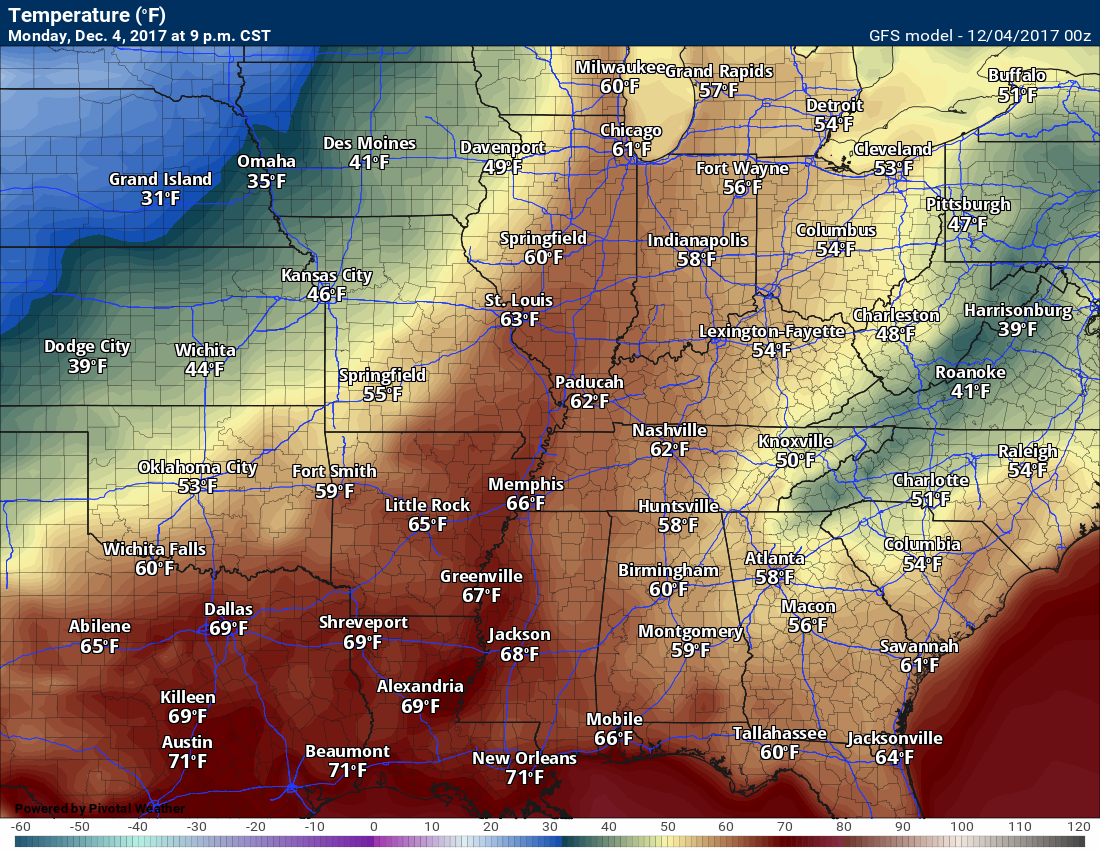
It will be warm today with temperatures in the 65 to 70-degree range. Some reporting stations should top 70 degrees! WELL above normal. Normal high temperatures for today are in the 46 to 50-degree range.
Temperatures will rise ahead of the front and fall behind the front.
Here is the Monday 9 PM temperature map. Notice the warm air surging northward ahead of our cold front.
.
.
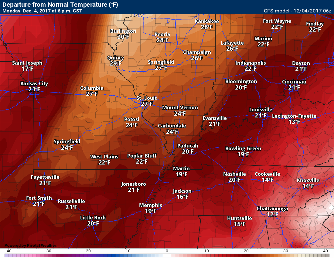
Temperature anomaly map from the GFS model guidance.
Well above normal temperatures (6 PM map)
.
.
.
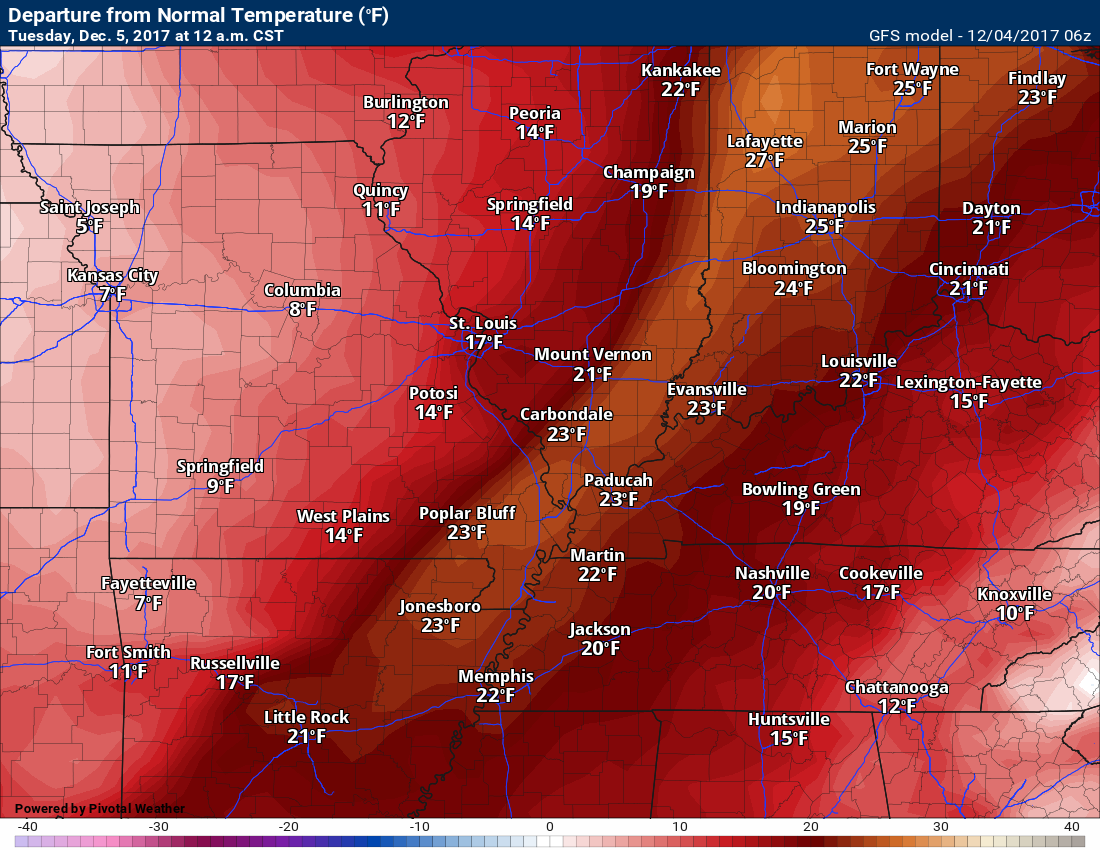
Temperatures spike ahead of our cold front with well above normal temperatures, as well.
This map is at 12 AM Tuesday morning. You can make out where the front is located. That is where temperature anomalies spike the highest.
.
.
.
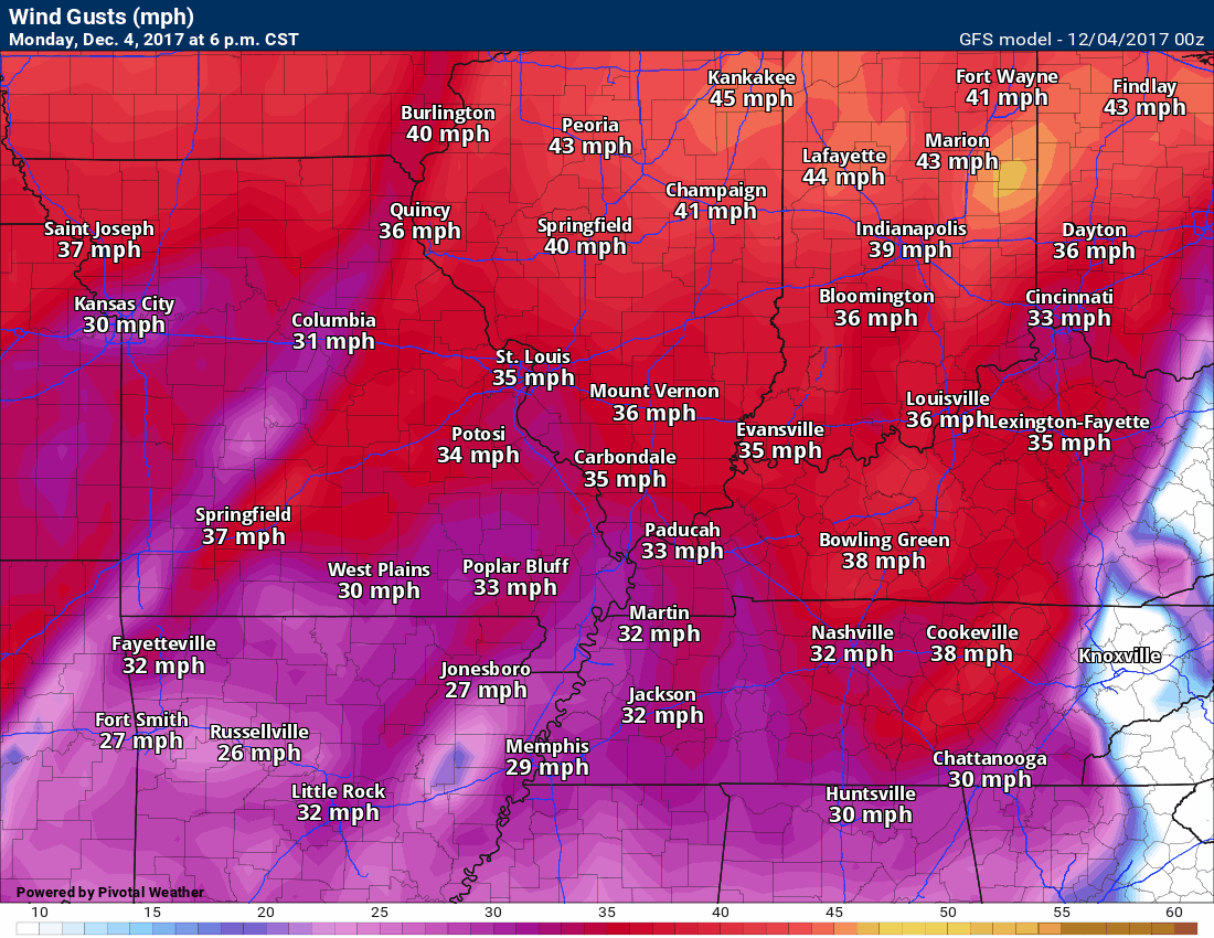
Gusty southerly winds today will blow around some of those outdoor decorations. You can expect wind gusts to top 35 mph from time to time. These winds will continue into Tuesday morning.
Here is the wind gust map from the GFS guidance. You can see the winds will be gusty into tonight and tomorrow.
Click image for a larger view. This image runs from Monday evening into Wednesday afternoon.
The timestamp is located on the upper left-hand side of the image.
.
.
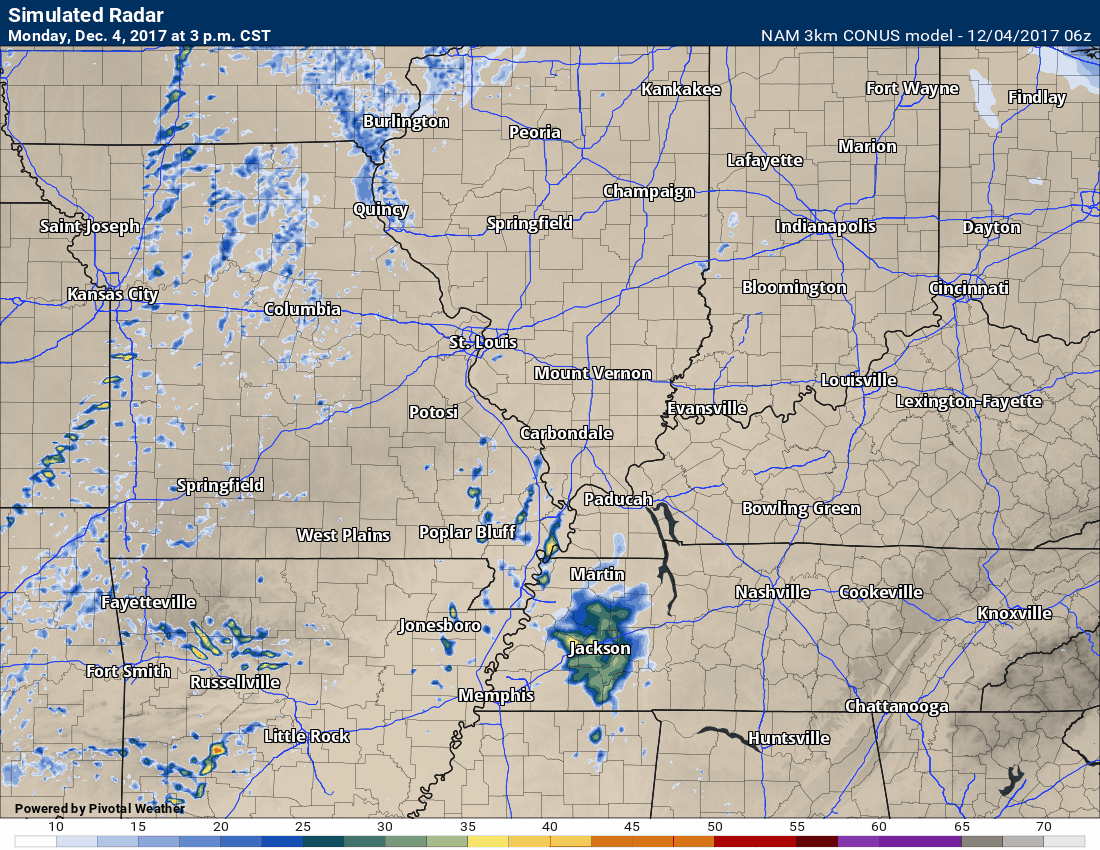
Widespread showers and thunderstorms will arrive tonight. This will occur ahead of a cold front that will swing through our region late tonight into Tuesday morning.
Here is the high-resolution 3K NAM guidance. Some of the storms could be locally strong.
.
.
.
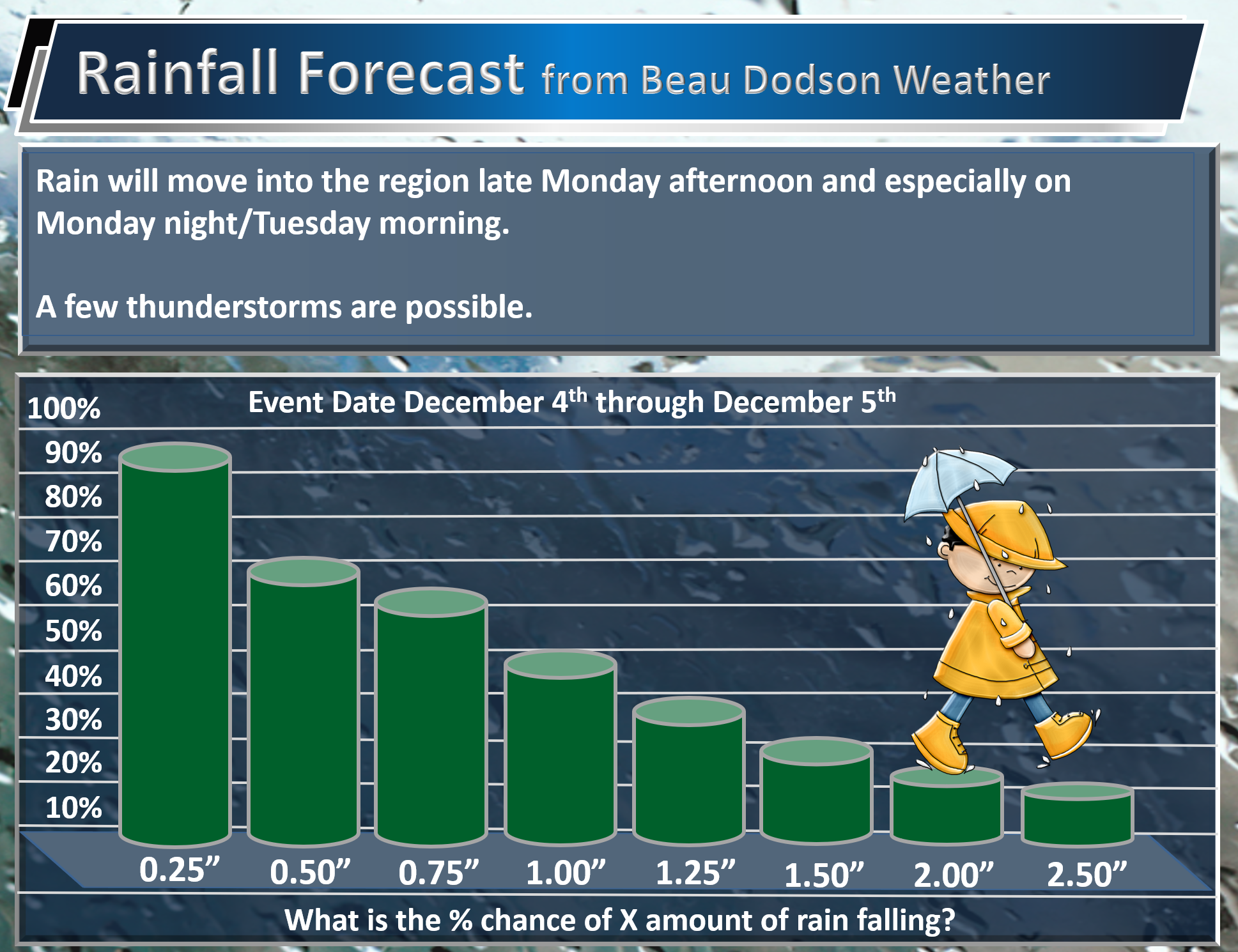
No change in my rainfall forecast. You can expect widespread 0.25″ to 0.50″. You can expect pockets of greater than one inch.
.
.
We need this rain. Missouri is suffering from drought conditions.
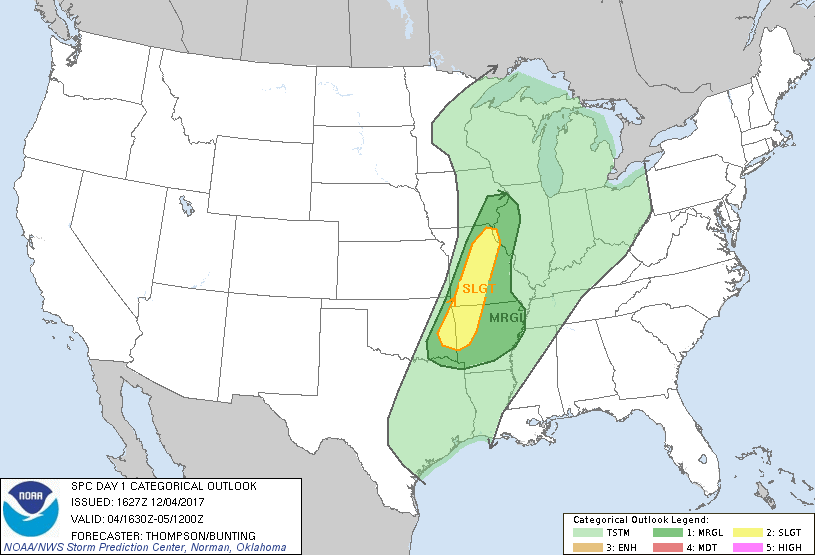
The threat of severe weather over the next 24 hours is low. I can’t rule out a few thunderstorms producing strong and gusty winds.
Here is the latest Storm Prediction Center outlook for severe weather. The light green represents general thunderstorms (non-severe). The dark green is a marginal (category one out of five) risk. Ther could adjust that dark green area as we move through the day. Either way, my forecast will remain unchanged.
.
.
.
Again, the overall severe weather threat is low.
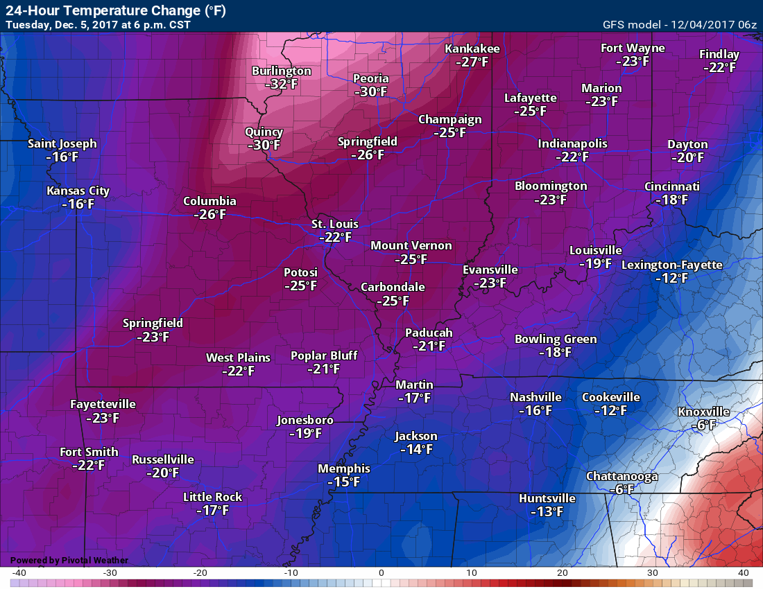
There will be a big difference in temperatures from Monday afternoon to Tuesday afternoon. Temperatures will have fallen 20+ degrees over much of the area.
HIghs on Tuesday will top out in the 40’s. Quite the change from recent days.
Here is the 24-hour temperature change map. This is from 6 PM on Monday to 6 PM on Tuesday. Big difference between today and tomorrow.
.
.
.
Highs on Wednesday into the weekend will be even colder.
Highs on Thursday, Friday, Saturday, and Sunday will likely remain in the 30’s. If we have snow on the ground then temperatures will remain in the 20’s for daytime highs.
Overnight lows will drop into the teens and 20s.
Wind chills will likely drop into the single digits and teens by Friday, Saturday, and Sunday.
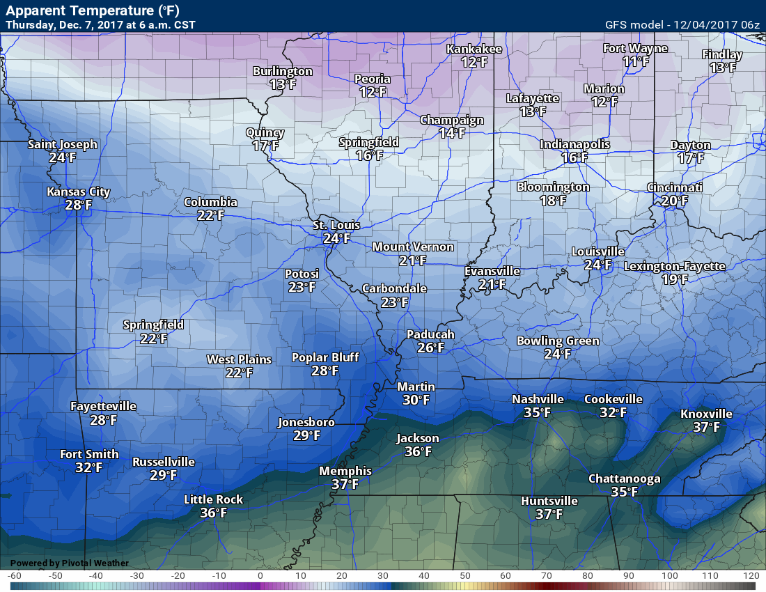
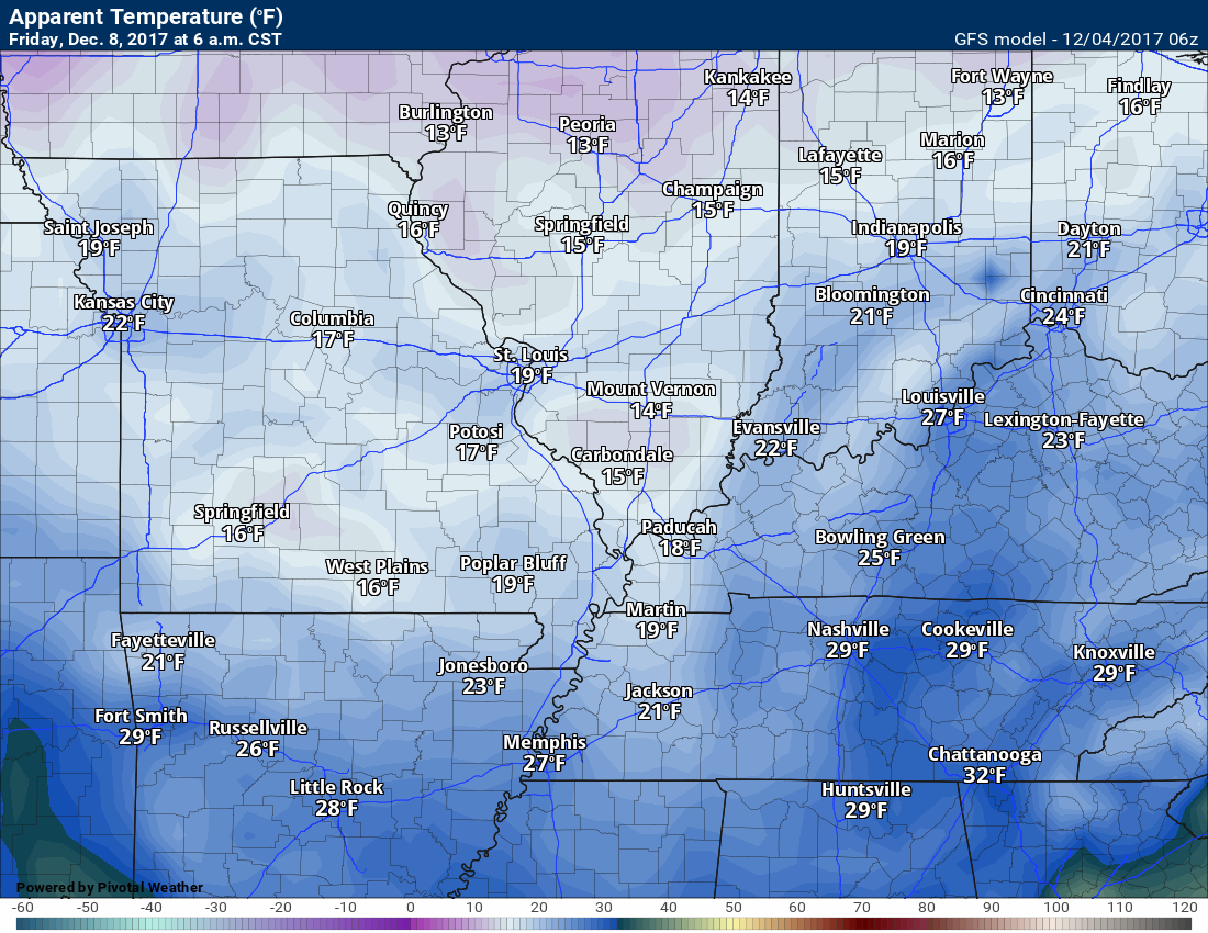
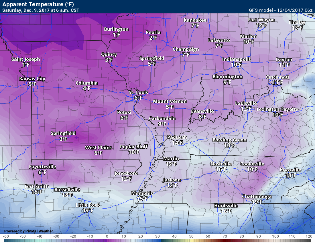
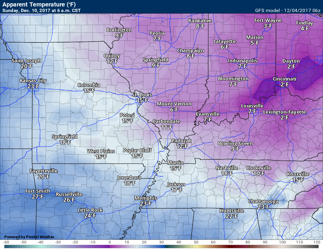
Here are the wind chills maps for 6 am on Thursday through Sunday. The Saturday and Sunday numbers are dependent on snow. If we have snow on the ground then these wind chill values will verify. Even without snow on the ground, it will be bitterly cold.
Thursday wind chill map for 6 AM
.
.
Friday wind chill map for 6 AM
.
.
Saturday wind chill map for 6 AM
.
.
Sunday wind chill map for 6 AM
.
.
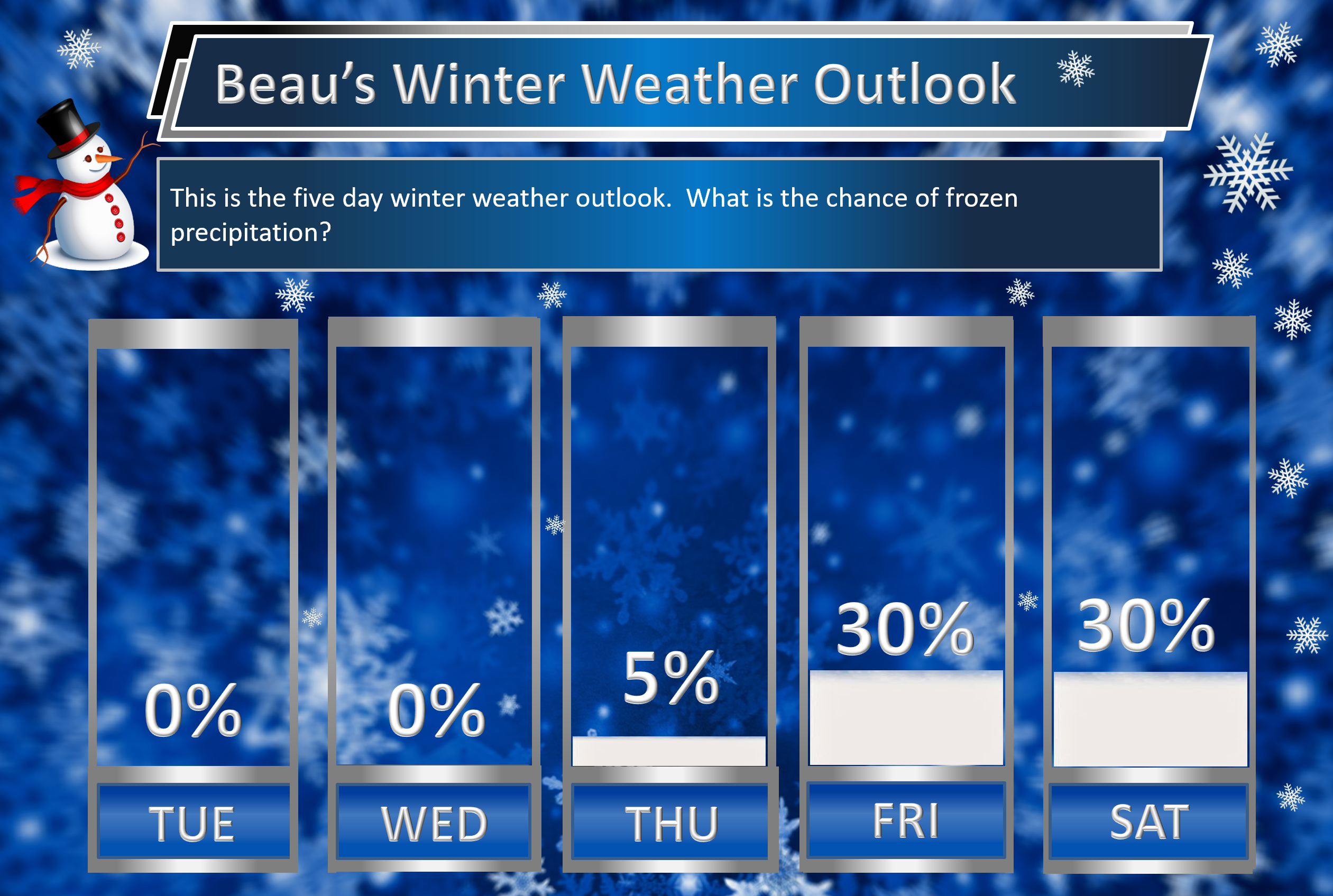
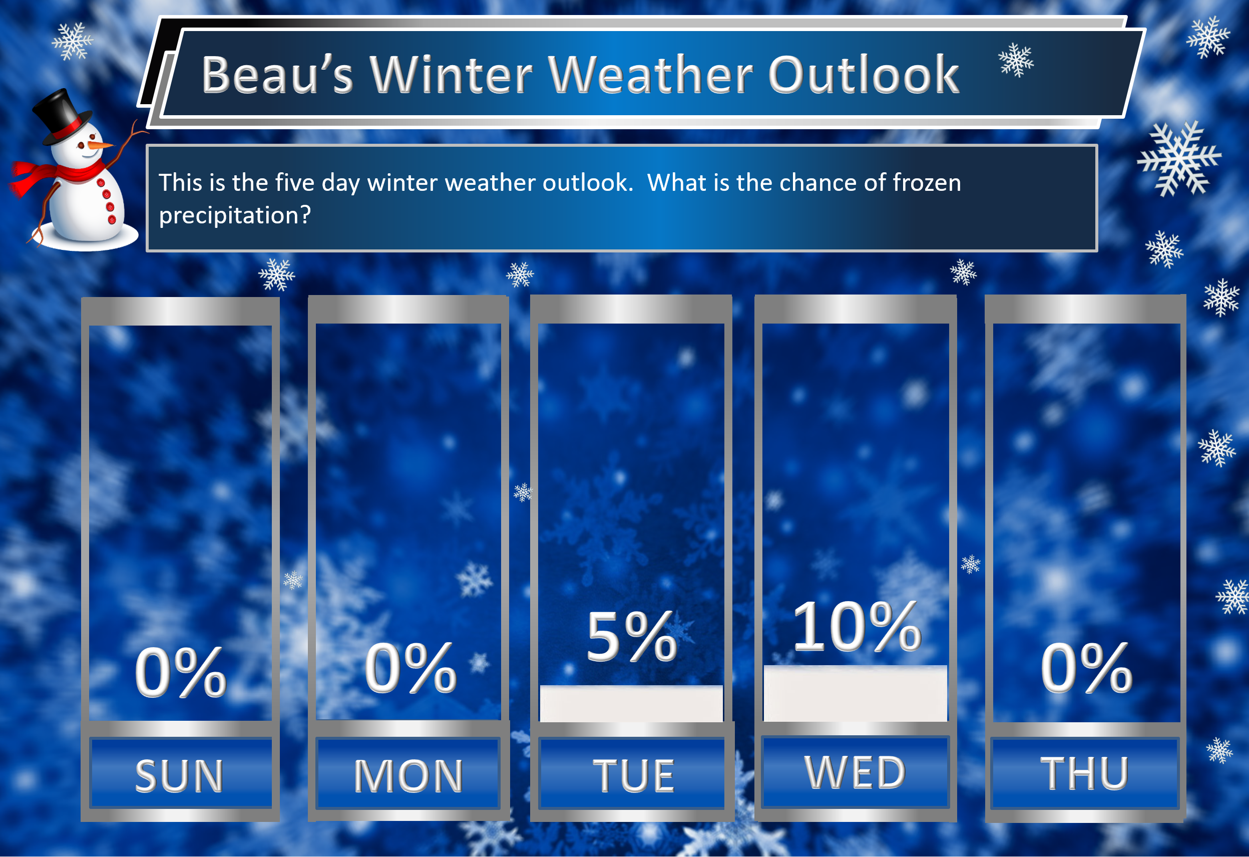
Beau’s Winter Weather Outlook
The next big question is snow. Will it or won’t it snow?
It is still too early to make an accurate forecast concerning the chance of snow Thursday night into Saturday. For that matter, next week, as well.
Several disturbances will move into our region from the northwest. The exact track of each disturbance will determine who receives snow. One thing seems almost certain, it will be cold enough for snow.
Here are my latest snow probability maps. These graphics have nothing to do with accumulation. This is simply the forecast probability for snow falling.
.
For the third day in a row, the numbers have increased.
.
.
.
Models vary on snow totals. This will be a clipper system. Typically they produce more snow than anticipated. They also produce a fluffier snow. This is because of the cold temperatures. Snow ratios are normally 10:1. That means one inch of snow equals 0.10″ of melted liquid. Clippers can easily produce 15:1 and higher.
Perhaps the greatest risk for snow will be over southern Illinois and northwest Kentucky. Still early for confidence. It could very well miss us entirely.


We offer regional radars and local city radars – if a radar does not update then try another one. Occasional browsers need their cache cleared. You may also try restarting your browser. This will usually fix any problems.
During the winter you can track snow and ice by clicking the winterize button on the local city view interactive radars.
You may email me at beaudodson@usawx.com
Interactive Weather Radar Page. Choose the city nearest your location: Click this link
National interactive radar: Click this link.