The digital media blog is free for everyone today.
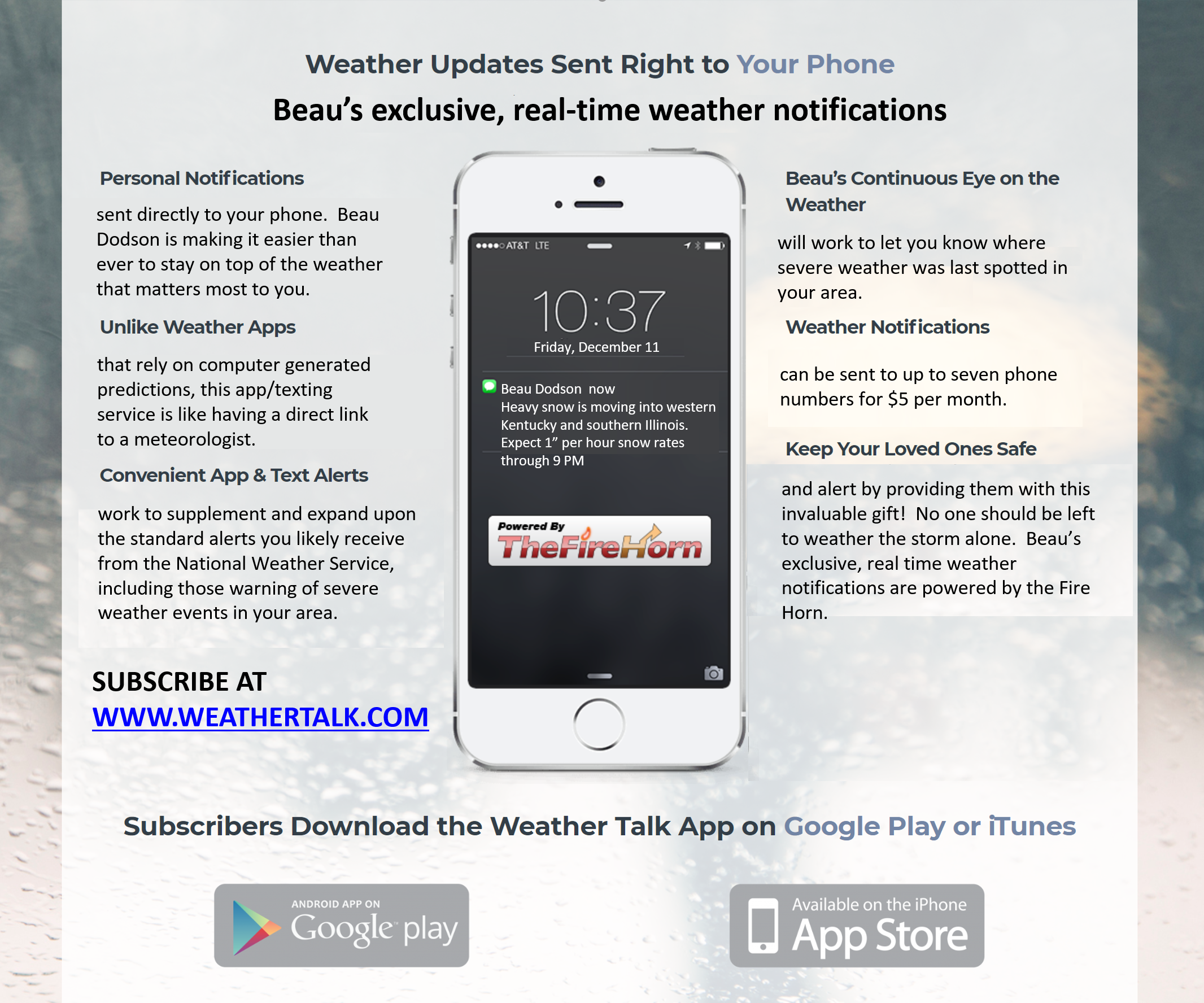
I would like you to subscribe and help support the weather data. You may do that at www.weathertalk.com You can now have up to severe phones for $5 a month!
I will post updates throughout the day here on the weather blog. Keep checking back.
2 PM
All severe weather concerns have ended for the region.
I am monitoring Wednesday into Friday for a rain and wintry mix event.
There remain quite a few questions about precipitation type and timing.
Monitor updates.
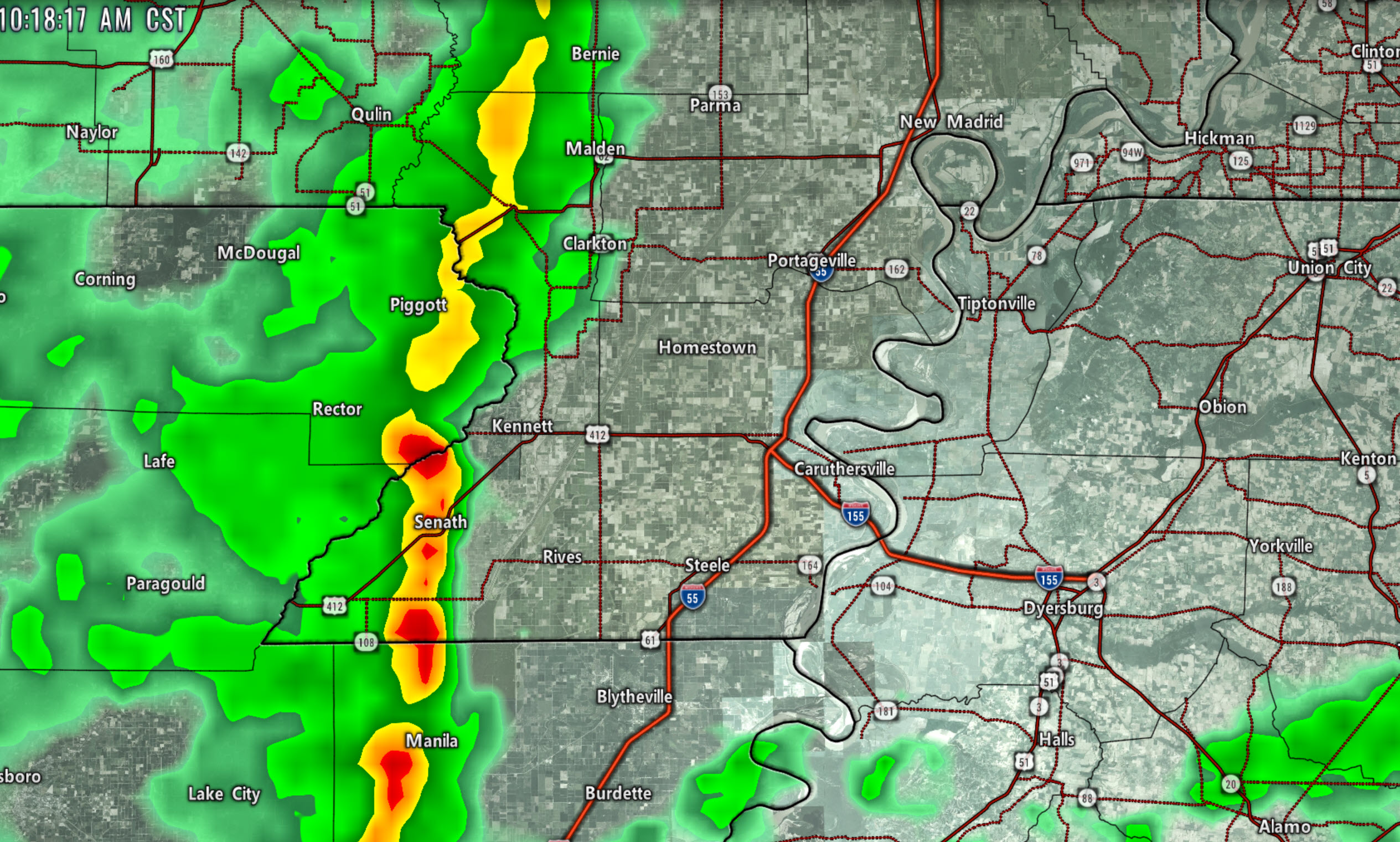
1:18 PM
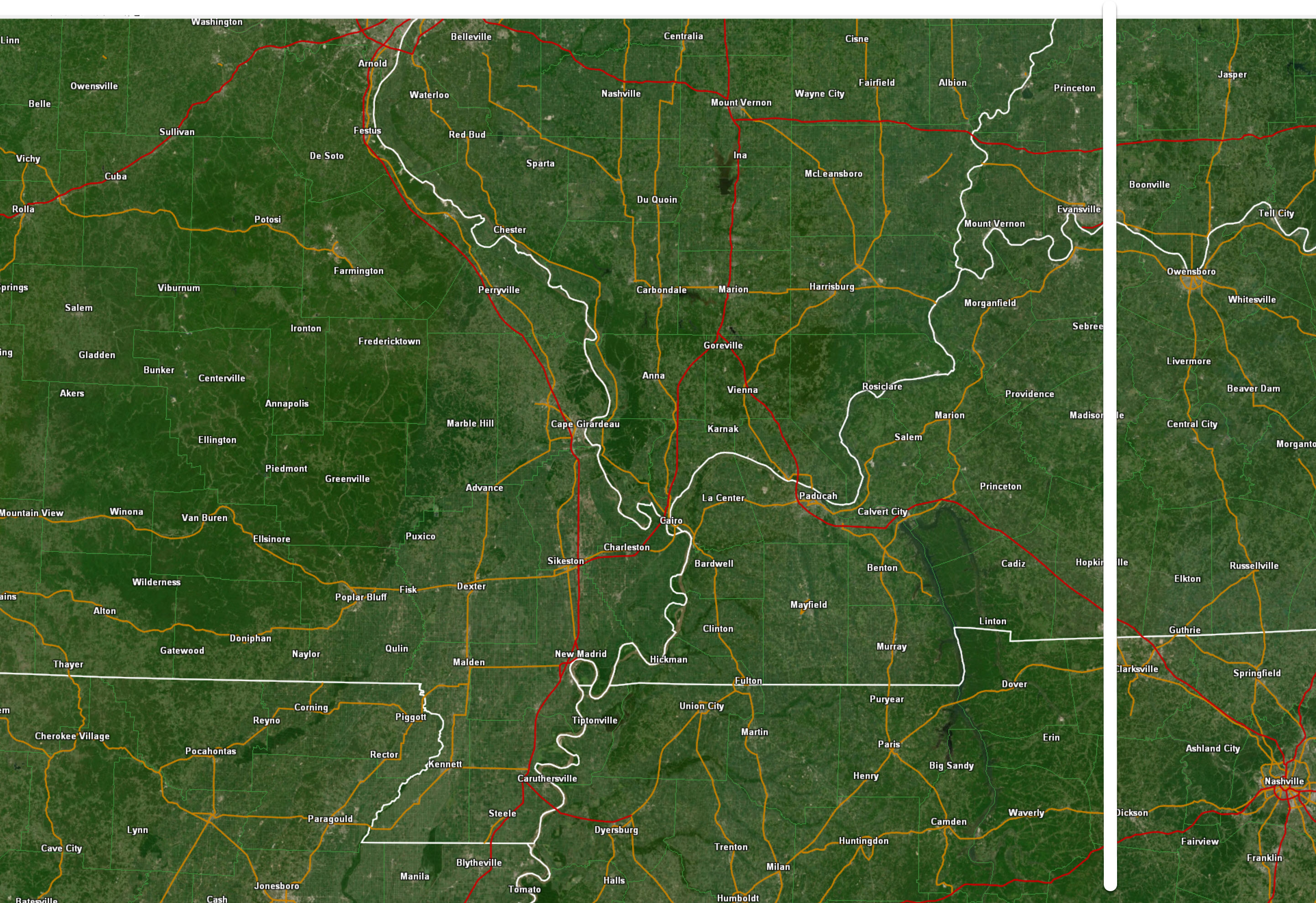
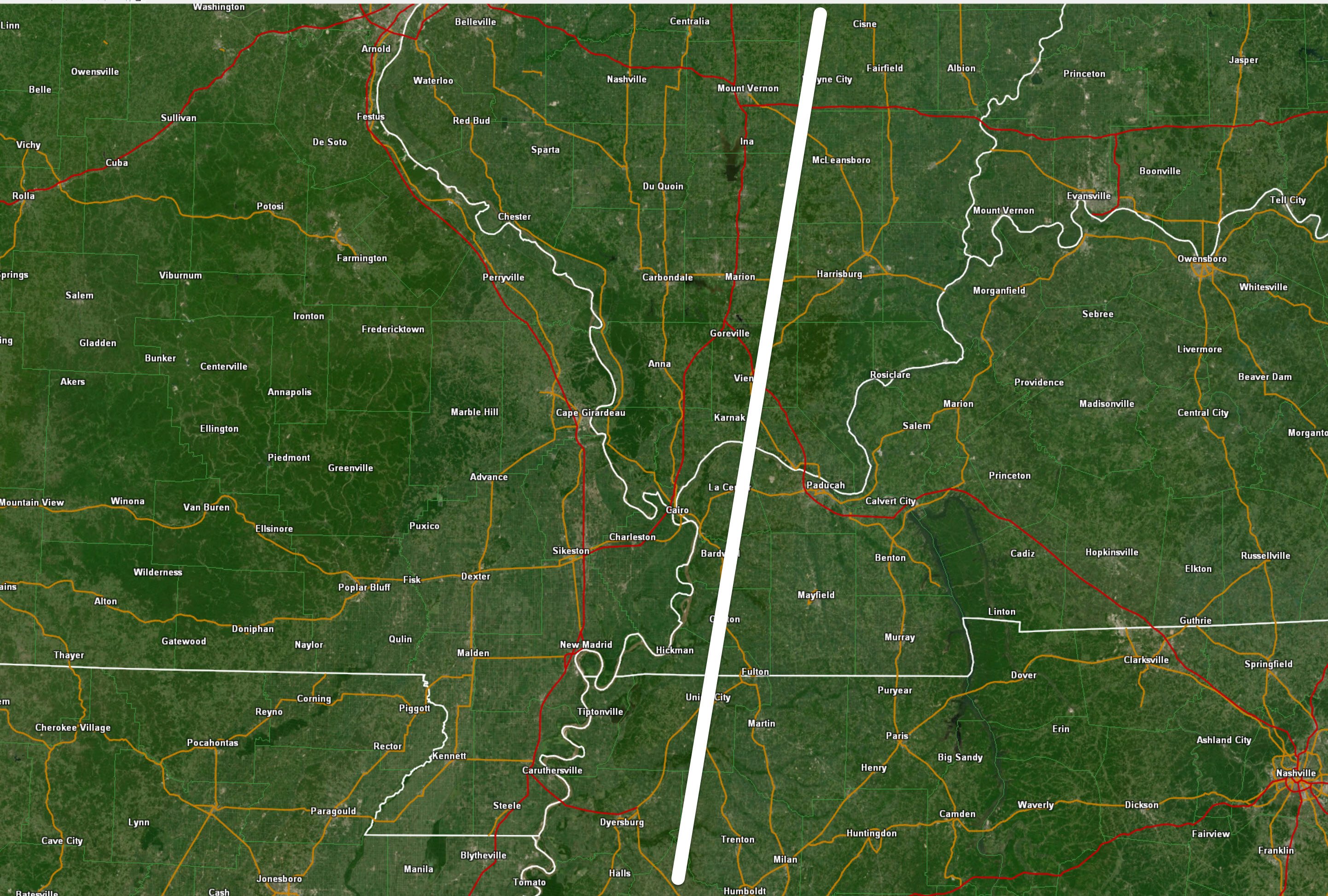
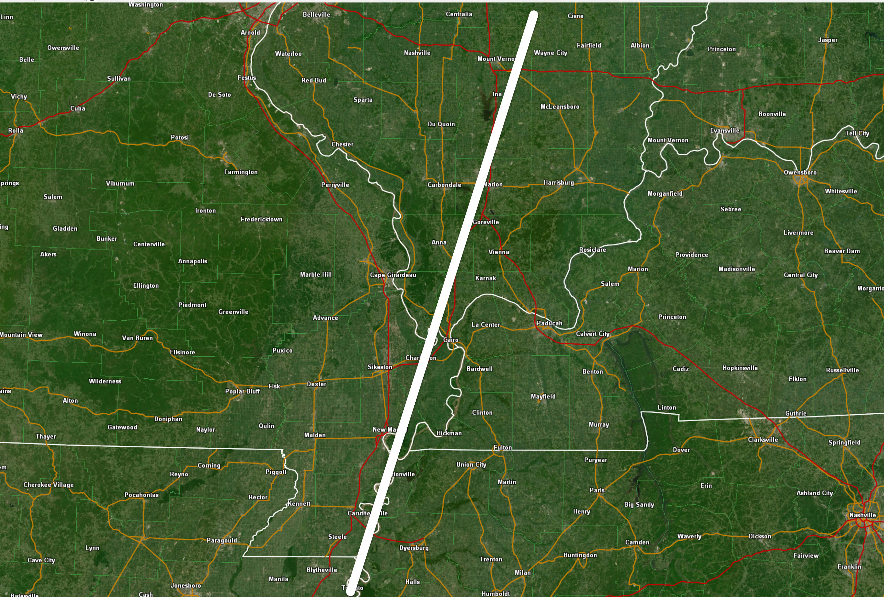
Areas to the left of the white line are cleared from any severe weather concerns the rest of today.
12:30 PM
Line of storms is moving rapidly eastward. Winds of 45 to 55 mph are possible with the most intense thunderstorms.
Low end risk of a tornado this afternoon.
The threat ends once the line moves east.
11:48 PM
Tornado watch into this afternoon in the purple zone.
The threat ends as the line moves east.
11:40 AM
Severe risk is over to the left of the white line
11:30
Most guidance is showing the mid to late week event being a rain event. Uncertainty remains on track and intensity of the system.
11:15 AM
Severe risk is over to the left of the white line
10:45 AM
These storms are producing 30 to 45 mph wind gusts as they move over any given location.
The storms are gaining some strength. I can’t rule out some 50 mph gusts over coming hours. Perhaps higher.
The line is expanding.
Live radars click here http://weatherobservatory.com/weather-radar.htm

10:15 AM
A line of storms has formed in eastern Arkansas. It is moving east/northeast at 60 mph.
Some of these storms could produce strong and gusty winds.
Live radar link
http://weatherobservatory.com/radar_dyers.htm
10 AM radar
9:45 AM
Quick update on the mid to late week system.
NAM is mostly a rain event. Too warm for frozen precipitation. We still have several days to go before this one is ironed out.
Date and time-stamp upper left.
9 AM Update
Here is the high-resolution Hrrr
It is that thin line of storms that we need to monitor.
Click to enlarge
Time-stamp upper left.
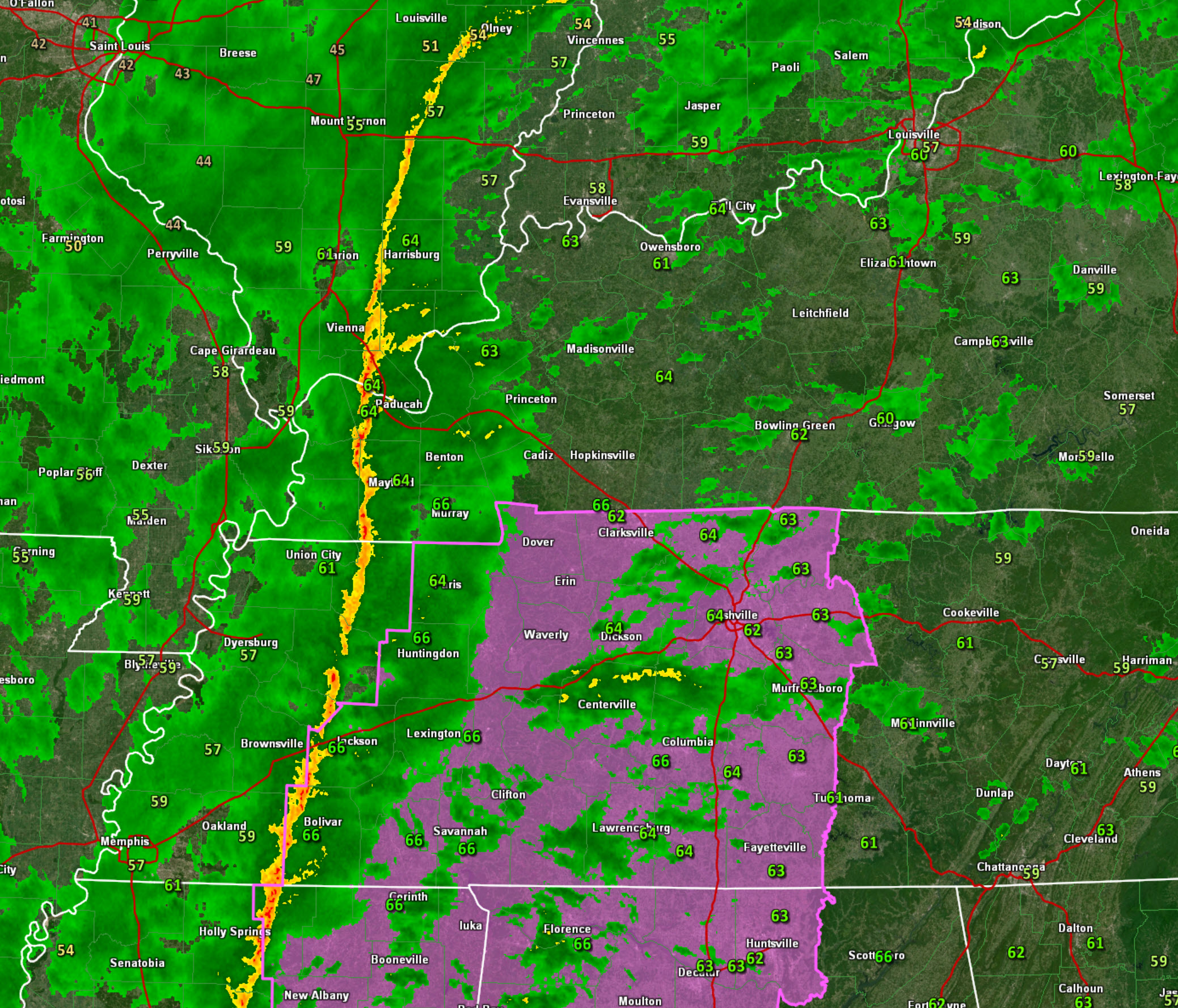
Current dew points. They are rising. That is one ingredient when thinking about severe weather.
The Justin Croach Memorial Scholarship

Daily WeatherTalk schedule

We offer interactive local city view radars and regional radars.
If a radar does not update then try another one. If a radar does not appear to be refreshing then hit Ctrl F5. You may also try restarting your browser.

Interactive Radars:
Interactive live weather radar page. Choose the city nearest your location. If one of the city radars won’t load then try a nearby one. Click here.
Live satellite views. Click here
December 31, 2018
Monday Forecast: Gusty winds. Cloudy. Widespread rain. Thunderstorms are possible. Locally heavy rain possible. A few storms could produce high winds (if storms form). A surge of warmer temperatures for the eastern half of the region tomorrow before the cold front arrives.
Is severe weather expected? If thunderstorms form they could produce high winds and isolated tornadoes. This would mainly be over western Kentucky and Tennessee
My confidence in the forecast verifying: High (90% confidence in the forecast)
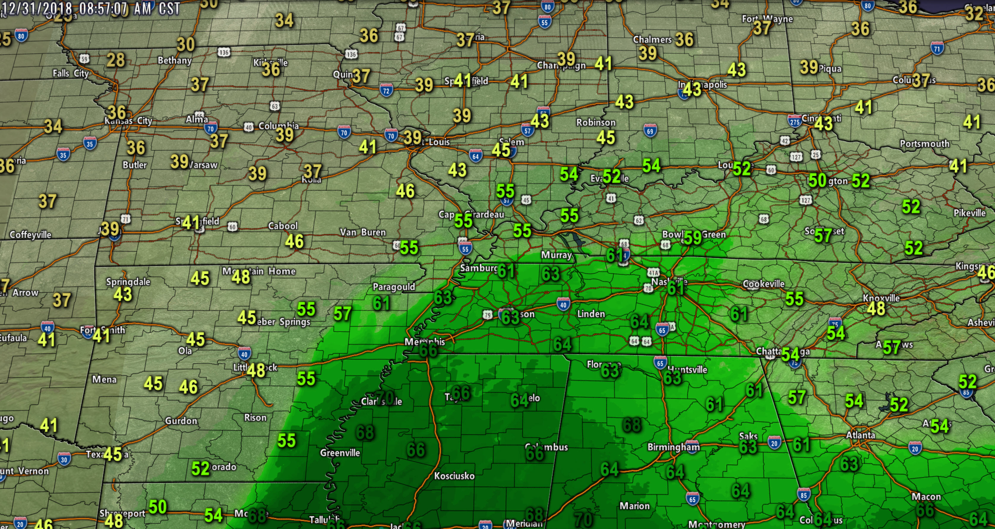
Temperature range: MO ~ 46 to 56 IL ~ 48 to 64 KY ~ 62 to 66 TN ~62 to 68
Wind direction and speed: Southeast wind becoming southwest at 15 to 30 mph and gusty
Wind chill (feels like) temperature forecast:
What is the chance/probability of precipitation? MO ~ 100% IL ~ 100% KY ~ 100% TN ~ 100%
Coverage of precipitation: Widespread
Is flash flooding anticipated? Low-end risk. Monitor updates.
Is accumulating snow or ice anticipated? No
Is non-accumulating snow or ice anticipated? No
Are icy road conditions anticipated? No
What impacts are anticipated from the weather? Gusty wind. Wet roadways. Monitor the risk of flooding. Monitor the risk of severe weather.
The NWS officially defines severe weather as 58 mph wind or great, 1″ hail or larger, and/or tornadoes
Will lightning be possible? Yes
Should I cancel my outdoor plans? Have a plan B
Will the weather impact my outdoor plans? Rain will likely interfere with outdoor activities. Gusty winds, as well.
UV Index: 1 Low
Sunrise: 7:10 AM
Monday Night Forecast Details:
Forecast: Cloudy. Rain ending early in the night. Rain may end before sunset. Chilly.
My confidence in the forecast verifying: Medium (60% confidence in the forecast)
Temperature range: MO ~ 28 to 34 IL ~ 28 to 34 KY ~ 34 to 38 TN ~ 35 to 38
Wind direction and speed: West and northwest at 5 to 10 mph with gusts to 30 mph
Wind chill (feels like) temperature forecast: 25 to 35
What is the chance/probability of precipitation? MO ~ 10% early IL ~ 10% early KY ~ 30% before 7 PM TN ~ 30% before 7 PM
Coverage of precipitation: Ending
Is flash flooding anticipated? Streams and rivers may rise. Locally heavy rain on Monday will need to run off.
Is accumulating snow or ice anticipated? No
Is non-accumulating snow or ice anticipated? Most likely no
Are icy road conditions anticipated? No
Is severe weather expected? Most likely no. The thunderstorm risk would have shifted east.
The NWS officially defines severe weather as 58 mph wind or great, 1″ hail or larger, and/or tornadoes
Will lightning be possible? Most likely no
What impacts are anticipated from the weather? Wet roadways are possible early in the night.
Should I cancel my outdoor plans? I would not cancel plans. I would monitor radars.
Will the weather impact my outdoor plans? Damp conditions. Turning colder. Gusty winds during the evening hours.
Sunset: 4:47 PM
Moonrise: 1:54 AM Waning Crescent
Moonset: 1:20 PM
January 1, 2018
Tuesday Forecast: A mix of sun and clouds. More clouds than sun.
My confidence in the forecast verifying: High (80% confidence in the forecast)
Temperature range: MO ~ 36 to 44 IL ~ 36 to 44 KY ~ 40 to 45 TN ~ 40 to 45
Wind direction and speed: North and northwest at 6 to 12 mph with gusts to 15 mph
Wind chill (feels like) temperature forecast: 25 to 35
What is the chance/probability of precipitation? MO ~ 0% IL ~ 0% KY ~ 0% TN ~ 0%
Coverage of precipitation: None
Is flash flooding anticipated? No
Is accumulating snow or ice anticipated? No
Is non-accumulating snow or ice anticipated? No
Are icy road conditions anticipated? No
Is severe weather expected? No
The NWS officially defines severe weather as 58 mph wind or great, 1″ hail or larger, and/or tornadoes
Will lightning be possible? No
What impacts are anticipated from the weather? None
Should I cancel my outdoor plans? No
Will the weather impact my outdoor plans? None
UV Index: 2 to 3 Low
Sunrise: 7:10 AM
Tuesday Night Forecast Details:
Forecast: Mostly cloudy. Cool.
My confidence in the forecast verifying: High (80% confidence in the forecast)
Temperature range: MO ~ 26 to 32 IL ~ 264 to 32 KY ~ 30 to 35 TN ~ 30 to 35
Wind direction and speed: North at 5 to 10 mph
Wind chill (feels like) temperature forecast: 20 to 30
What is the chance/probability of precipitation? MO ~ 0% IL ~ 0% KY ~ 0% TN ~ 0%
Coverage of precipitation: None
Is flash flooding anticipated? No
Is accumulating snow or ice anticipated? No
Is non-accumulating snow or ice anticipated? No
Are icy road conditions anticipated? No
Is severe weather expected? No
The NWS officially defines severe weather as 58 mph wind or great, 1″ hail or larger, and/or tornadoes
Will lightning be possible? No
What impacts are anticipated from the weather? None
Should I cancel my outdoor plans? No
Will the weather impact my outdoor plans? Cold air will make it uncomfortable for those outside.
Sunset: 4:48 PM
Moonrise: 2:56 AM Waning Crescent
Moonset: 1:53 PM
A winter storm may move across portions of the central and southern United States Wednesday into Friday.
This system needs to be monitored. What type of precipitation it brings into our region remains a question.
More and more data indicates mostly a rain event.
January 2, 2018
Wednesday Forecast: Increasing clouds. Cool. A chance of a shower near the MO/AR and KY/TN border southward. A southern system may clip our local area.
My confidence in the forecast verifying: Medium (30% confidence in the forecast)
Temperature range: MO ~ 35 to 40 IL ~ 35 to 40 KY ~ 36 to 44 TN ~ 38 to 44
Wind direction and speed: West at 6 to 12 mph with gusts to 15 mph
Wind chill (feels like) temperature forecast: 25 to 35
What is the chance/probability of precipitation? MO ~ 10% IL ~ 10% KY ~ 20% TN ~ 20%
Coverage of precipitation: None to scattered (southern counties)
Is flash flooding anticipated? No
Is accumulating snow or ice anticipated? No
Is non-accumulating snow or ice anticipated? Possible
Are icy road conditions anticipated? No
Is severe weather expected? No
The NWS officially defines severe weather as 58 mph wind or great, 1″ hail or larger, and/or tornadoes
Will lightning be possible? No
What impacts are anticipated from the weather? A few wet roadways over our southern counties (near MO/AR and KY/TN border)
Should I cancel my outdoor plans? No
Will the weather impact my outdoor plans? For most areas, no. Monitoring our southern counties as a system may clip us.
UV Index: 2 to 3 Low
Sunrise: 7:10 AM
Wednesday Night Forecast Details:
Forecast: Cloudy. A slight chance of rain or a wintry mix.
My confidence in the forecast verifying: LOW (30% confidence in the forecast)
Temperature range: MO ~ 26 to 34 IL ~ 26 to 34 KY ~ 28 to 34 TN ~ 28 to 34
Wind direction and speed: West at 6 to 12 mph
Wind chill (feels like) temperature forecast: 15 to 25
What is the chance/probability of precipitation? MO ~ 20% IL ~ 20% KY ~ 20% TN ~ 30%
Coverage of precipitation: Scattered mainly near the AR/MO and KY/TN border southward.
Is flash flooding anticipated? No
Is accumulating snow or ice anticipated? Monitor. Most likely no.
Is non-accumulating snow or ice anticipated? Monitor
Are icy road conditions anticipated? Most likely no but monitor updates
Is severe weather expected? No
The NWS officially defines severe weather as 58 mph wind or great, 1″ hail or larger, and/or tornadoes
Will lightning be possible? No
Should I cancel my outdoor plans? No
What impacts are anticipated from the weather? Wet roadways
Will the weather impact my outdoor plans? No
Sunset: 4:49 PM
Moonrise: 3:56 AM Waning Crescent
Moonset: 2:30 PM
January 3, 2018
Thursday Forecast: Intervals of clouds. Chilly.
My confidence in the forecast verifying: Medium (40% confidence in the forecast)
Temperature range: MO ~ 40 to 45 IL ~ 40 to 45 KY ~ 40 to 45 TN ~ 40 to 45
Wind direction and speed: Northeast at 6 to 12 mph
Wind chill (feels like) temperature forecast:
What is the chance/probability of precipitation? MO ~ 10% IL ~ 10% KY ~ 10% TN ~ 10%
Coverage of precipitation: Most likely none but monitor updates.
Is flash flooding anticipated? No
Is accumulating snow or ice anticipated? No
Is non-accumulating snow or ice anticipated? Unlikely
Are icy road conditions anticipated? No
Is severe weather expected? No
The NWS officially defines severe weather as 58 mph wind or great, 1″ hail or larger, and/or tornadoes
Will lightning be possible? No
What impacts are anticipated from the weather? Most likely none
Should I cancel my outdoor plans? No
Will the weather impact my outdoor plans? No
UV Index: 2 Low
Sunrise: 7:10 AM
Thursday Night Forecast Details:
Forecast: Intervals of clouds. Chilly. Rain or a wintry mix possible.
My confidence in the forecast verifying: LOW (30% confidence in the forecast)
Temperature range: MO ~ 32 to 38 IL ~ 32 to 38 KY ~ 34 to 44 TN ~ 34 to 44
Wind direction and speed: Northeast at 6 to 12 mph
Wind chill (feels like) temperature forecast: 15 to 25
What is the chance/probability of precipitation? MO ~ 30% IL ~ 30% KY ~ 30% TN ~ 30%
Coverage of precipitation: Scattered
Is flash flooding anticipated? Monitor
Is accumulating snow or ice anticipated? Monitor
Is non-accumulating snow or ice anticipated? Monitor
Are icy road conditions anticipated? Monitor
Is severe weather expected? Monitor
The NWS officially defines severe weather as 58 mph wind or great, 1″ hail or larger, and/or tornadoes
Will lightning be possible? Monitor
Should I cancel my outdoor plans? Monitor
What impacts are anticipated from the weather? Wet roadways. Monitor updates. Perhaps icy roads.
Will the weather impact my outdoor plans? Monitor
Sunset: 4:49 PM
Moonrise: 4:56 AM Waning Crescent
Moonset: 3:11 PM
January 4, 2018
Friday Forecast: Cloudy with rain showers likely. I will monitor temperatures.
My confidence in the forecast verifying: LOW (30% confidence in the forecast)
Temperature range: MO ~ 38 to 44 IL ~ 38 to 44 KY ~ 38 to 44 TN ~ 40 to 45
Wind direction and speed: North at 5 to 10 mph with gusts to 20 mph
Wind chill (feels like) temperature forecast: 30 to 40
What is the chance/probability of precipitation? MO ~ 30% IL ~ 30% KY ~ 30% TN ~ 30%
Coverage of precipitation: Perhaps widespread
Is flash flooding anticipated? Monitor updates
Is accumulating snow or ice anticipated? No
Is non-accumulating snow or ice anticipated? Unlikely
Are icy road conditions anticipated? No
Is severe weather expected? Monitor updates
The NWS officially defines severe weather as 58 mph wind or great, 1″ hail or larger, and/or tornadoes
Will lightning be possible? Monitor updates
What impacts are anticipated from the weather? Wet roadways.
Should I cancel my outdoor plans? Monitor updates
Will the weather impact my outdoor plans? Monitor updates
UV Index: 2 Low
Sunrise: 7:10 AM
Friday Night Forecast Details:
Forecast: Evening clouds. Some clearing overnight.
My confidence in the forecast verifying: Medium (40% confidence in the forecast)
Temperature range: MO ~ 26 to 32 IL ~ 26 to 32 KY ~ 28 to 32 TN ~ 28 to 34
Wind chill (feels like) temperature forecast:
What is the chance/probability of precipitation? MO ~ 0% IL ~ 0% KY ~ 10% TN ~10%
Coverage of precipitation: Ending
Is flash flooding anticipated? No
Is accumulating snow or ice anticipated? No
Is non-accumulating snow or ice anticipated? No
Are icy road conditions anticipated? No
Wind direction and speed:
Is severe weather expected? No
The NWS officially defines severe weather as 58 mph wind or great, 1″ hail or larger, and/or tornadoes
Will lightning be possible? No
Should I cancel my outdoor plans? No, but check radars
What impacts are anticipated from the weather? Maybe some wet roadways.
Will the weather impact my outdoor plans? Monitor updates
Sunset: 4:50 PM
Moonrise: 5:53 AM Waning Crescent
Moonset: 3:55 PM
January 5, 2018
Saturday Forecast: Partly cloudy.
My confidence in the forecast verifying: Medium (60% confidence in the forecast)
Temperature range: MO ~ 48 to 54 IL ~ 48 to 54 KY ~ 48 to 54 TN ~ 48 to 54
Wind direction and speed: Southwest at 5 to 10 mph
Wind chill (feels like) temperature forecast:
What is the chance/probability of precipitation? MO ~ 0% IL ~ 0% KY ~ 0% TN ~ 0%
Coverage of precipitation: None
Is flash flooding anticipated? No
Is accumulating snow or ice anticipated? No
Is non-accumulating snow or ice anticipated? No
Are icy road conditions anticipated? No
Is severe weather expected? No
The NWS officially defines severe weather as 58 mph wind or great, 1″ hail or larger, and/or tornadoes
Will lightning be possible? No
What impacts are anticipated from the weather? None
Should I cancel my outdoor plans? No
Will the weather impact my outdoor plans? None
UV Index: 3 Low
Sunrise: 7:10 AM
Saturday Night Forecast Details:
Forecast: Mostly clear.
My confidence in the forecast verifying: Medium (60% confidence in the forecast)
Temperature range: MO ~ 34 to 38 IL ~ 34 to 38 KY ~ 34 to 38 TN ~ 34 to 38
Wind direction and speed: Southwest at 5 mph
Wind chill (feels like) temperature forecast:
What is the chance/probability of precipitation? MO ~ 0% IL ~ 0% KY ~ 0% TN ~ 0%
Coverage of precipitation: None
Is flash flooding anticipated? No
Is accumulating snow or ice anticipated? No
Is non-accumulating snow or ice anticipated? No
Are icy road conditions anticipated? No
Is severe weather expected? No
The NWS officially defines severe weather as 58 mph wind or great, 1″ hail or larger, and/or tornadoes
Will lightning be possible? No
Should I cancel my outdoor plans? No
What impacts are anticipated from the weather? None
Will the weather impact my outdoor plans? No
Sunset: 4:51 PM
Moonrise: 6:45 AM Waning Crescent
Moonset: 4:43 PM
January 6, 2018
Sunday Forecast: Partly cloudy. Mild for January.
My confidence in the forecast verifying: Medium (40% confidence in the forecast)
Temperature range: MO ~ 48 to 54 IL ~ 48 to 54 KY ~ 48 to 54 TN ~ 48 to 54
Wind direction and speed: South at 6 to 12 mph
Wind chill (feels like) temperature forecast:
What is the chance/probability of precipitation? MO ~ 0% IL ~ 0% KY ~ 0% TN ~ 0%
Coverage of precipitation: None
Is flash flooding anticipated? No
Is accumulating snow or ice anticipated? No
Is non-accumulating snow or ice anticipated? No
Are icy road conditions anticipated? No
Is severe weather expected? No
The NWS officially defines severe weather as 58 mph wind or great, 1″ hail or larger, and/or tornadoes
Will lightning be possible? No
What impacts are anticipated from the weather? None
Should I cancel my outdoor plans? No
Will the weather impact my outdoor plans? None
UV Index: 3 Low
Sunrise: 7:10 AM
Sunday Night Forecast Details:
Forecast: Partly cloudy. A slight chance of rain showers.
My confidence in the forecast verifying: Medium (40% confidence in the forecast)
Temperature range: MO ~ 36 to 44 IL ~ 36 to 44 KY ~ 36 to 44 TN ~ 36 to 44
Wind direction and speed: Southeast at 10 mph
Wind chill (feels like) temperature forecast:
What is the chance/probability of precipitation? MO ~ 20% IL ~ 20% KY ~ 20% TN ~ 20%
Coverage of precipitation: Isolated
Is flash flooding anticipated? No
Is accumulating snow or ice anticipated? No
Is non-accumulating snow or ice anticipated? No
Are icy road conditions anticipated? No
Is severe weather expected? No
The NWS officially defines severe weather as 58 mph wind or great, 1″ hail or larger, and/or tornadoes
Will lightning be possible? No
Should I cancel my outdoor plans? No
What impacts are anticipated from the weather? Perhaps a few wet roadways.
Will the weather impact my outdoor plans? No
Sunset: 4:52 PM
Moonrise: 7:35 AM New
Moonset: 5:33 PM
Learn more about the UV index readings. Click here.
Wind forecast
See wind forecast above in the daily details
.

Monday and Monday night: Wintry precipitation is not anticipated.
Tuesday: Wintry precipitation is not anticipated.
Wednesday: Monitor updates. A storm system may approach our region from the southwest. The track of this system remains uncertain. Confidence in the forecast, during this time period, is low.
Wednesday night into Thursday night: Monitor updates. A storm system will approach our region from the southwest. The track of this system remains uncertain. Confidence in the forecast, during this time period, is low.
Friday: Monitor updates. A storm system will approach our region from the southwest. The track of this system remains uncertain. Confidence in the forecast, during this time period, is low.
Saturday: Wintry precipitation is not anticipated.

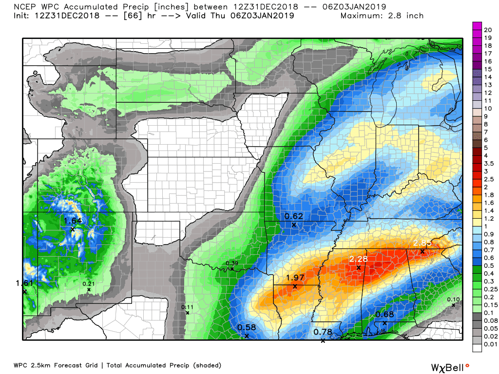
Here is the WPC/NOAA rainfall outlook.
Click to enlarge graphics on the blog.
Moderate to heavy rain is possible today.
I am forecasting generally 0.90″ to 1.80″ of rain. There will always be pockets of more and less during these events.
Subscribers, do you need a forecast for an outdoor event?

Did you know that you can find me on Twitter?


We offer interactive local city live radars and regional radars.
If a radar does not update then try another one. If a radar does not appear to be refreshing then hit Ctrl F5 on your keyboard.
You may also try restarting your browser. The local city view radars also have clickable warnings.
During the winter months, you can track snow and ice by clicking the winterize button on the local city view interactive radars.

Questions? Broken links? Other questions?
You may email me at beaudodson@usawx.com

The National Weather Service defines a severe thunderstorm as one that produces quarter size hail or larger, 58 mph winds or greater, and/or a tornado.
Today: Thunderstorms are possible today. A few of the storms could produce damaging wind gusts and even isolated tornadoes. Make sure your www.weathertalk.com account is up to date. I will be sending out app/text messages.
The time frame of concern will be 10 AM to 4 PM. The line of storms will push west to east at speeds of 60 mph.
Individual storm cells would be east/northeast.
Tuesday through Saturday: I am monitoring a system Thursday into Friday. Parts of our region could be in the warm sector. That would mean additional thunderstorm chances. Confidence in this remains low.
Interactive live weather radar page. Choose the city nearest your location. If one of the cities does not work then try a nearby one. Click here.
National map of weather watches and warnings. Click here.
Storm Prediction Center. Click here.
Weather Prediction Center. Click here.

Live lightning data: Click here.

Interactive GOES R satellite. Track clouds. Click here.

Here are the latest local river stage forecast numbers Click Here.
Here are the latest lake stage forecast numbers for Kentucky Lake and Lake Barkley Click Here.

- Milder air today with thunderstorms.
- Severe weather risk today.
- Monitoring a precipitation event Wednesday into Friday
Weather maps and discussion below (scroll down).
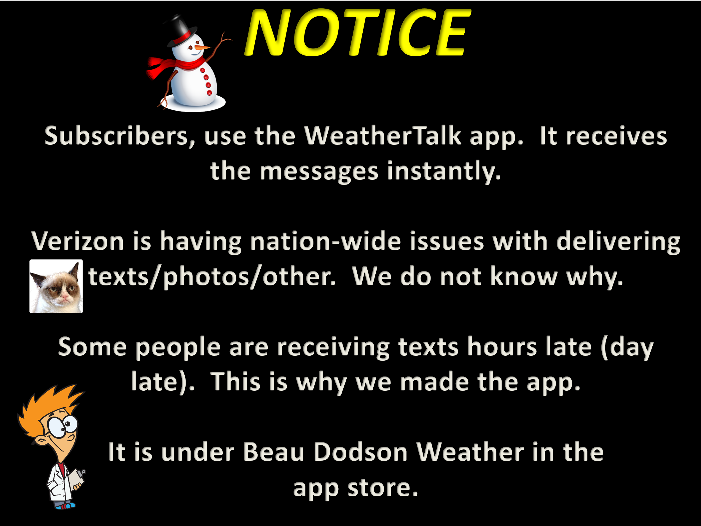
I will be sending out app/text messages today. Please use the app. The app receives the information faster than normal texting. Same messages but a different delivery type.
Make sure WeatherOne is turned on. That is the one for severe thunderstorms and tornadoes.
How to see if WeatherOne is turned on.
Sign into your www.weathertalk.com account
Click the Personal Notification Settings tab
Make sure WeatherOne is green
FORECAST
Today:
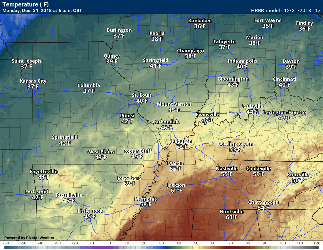
7 AM temperature map

The visible satellite shows clouds over our region.
Live satellite views. Click here
Click to enlarge

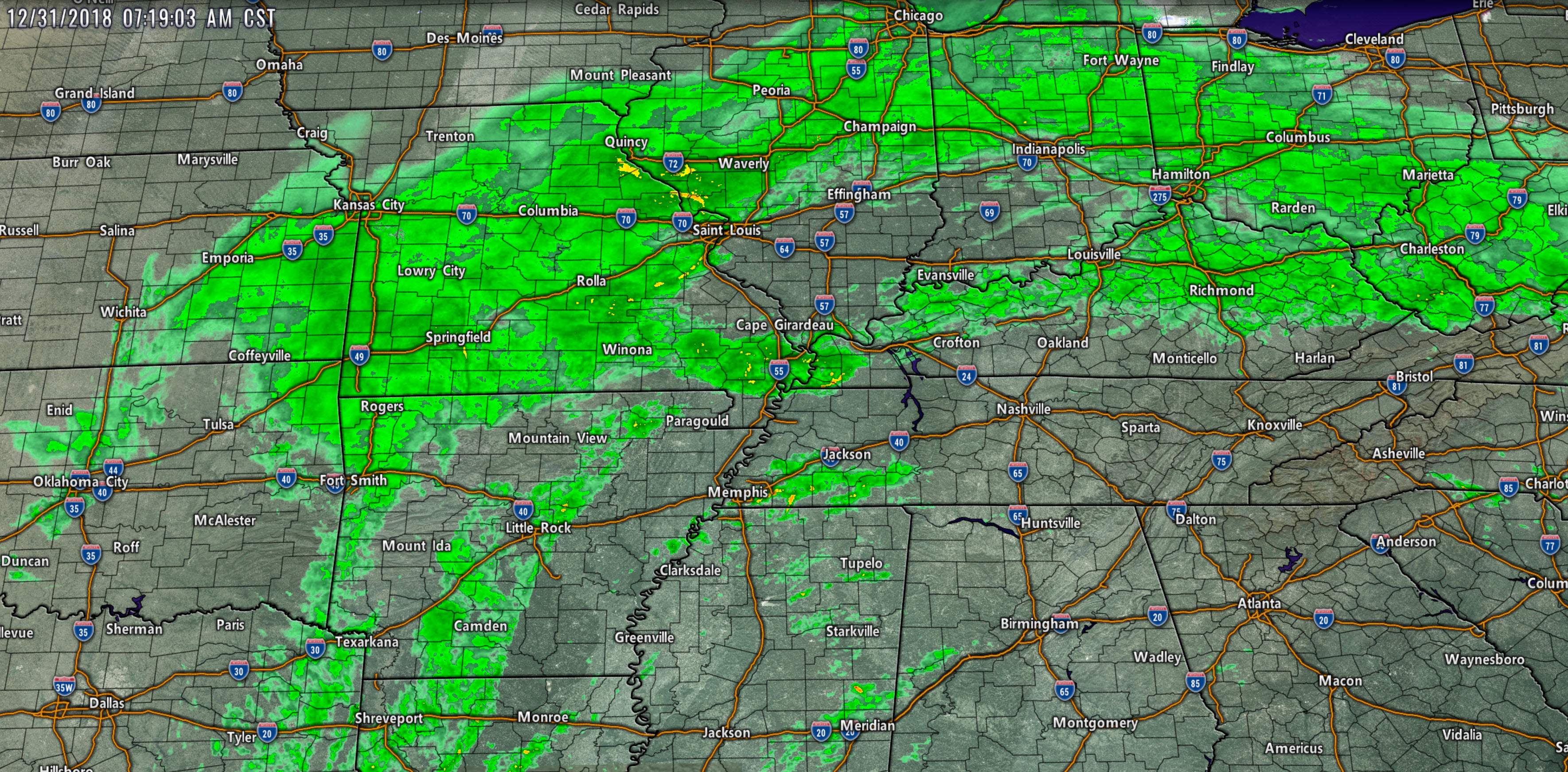
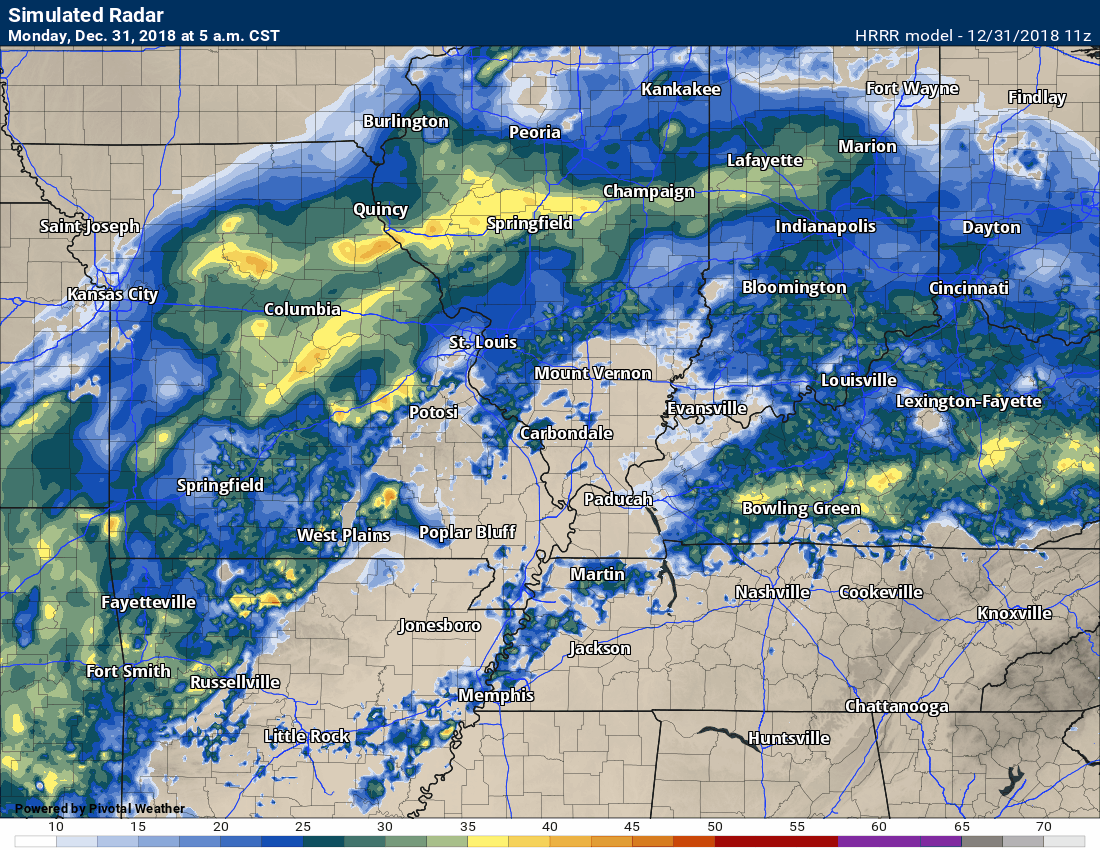
Here is the 7 AM radar
Plenty of rain on radar across the central United States
See live radars by clicking here RADARS
Today into Tuesday night:
Yes, it is winter. Today, however, it may feel more like spring. Not all that uncommon in our region. We seem to have a few of these days each winter.
Those wanting snow will not be receiving any today.
The big weather story today will be the risk of a few severe thunderstorms and warm temperatures (for some of us). Gusty winds will develop today, as well.
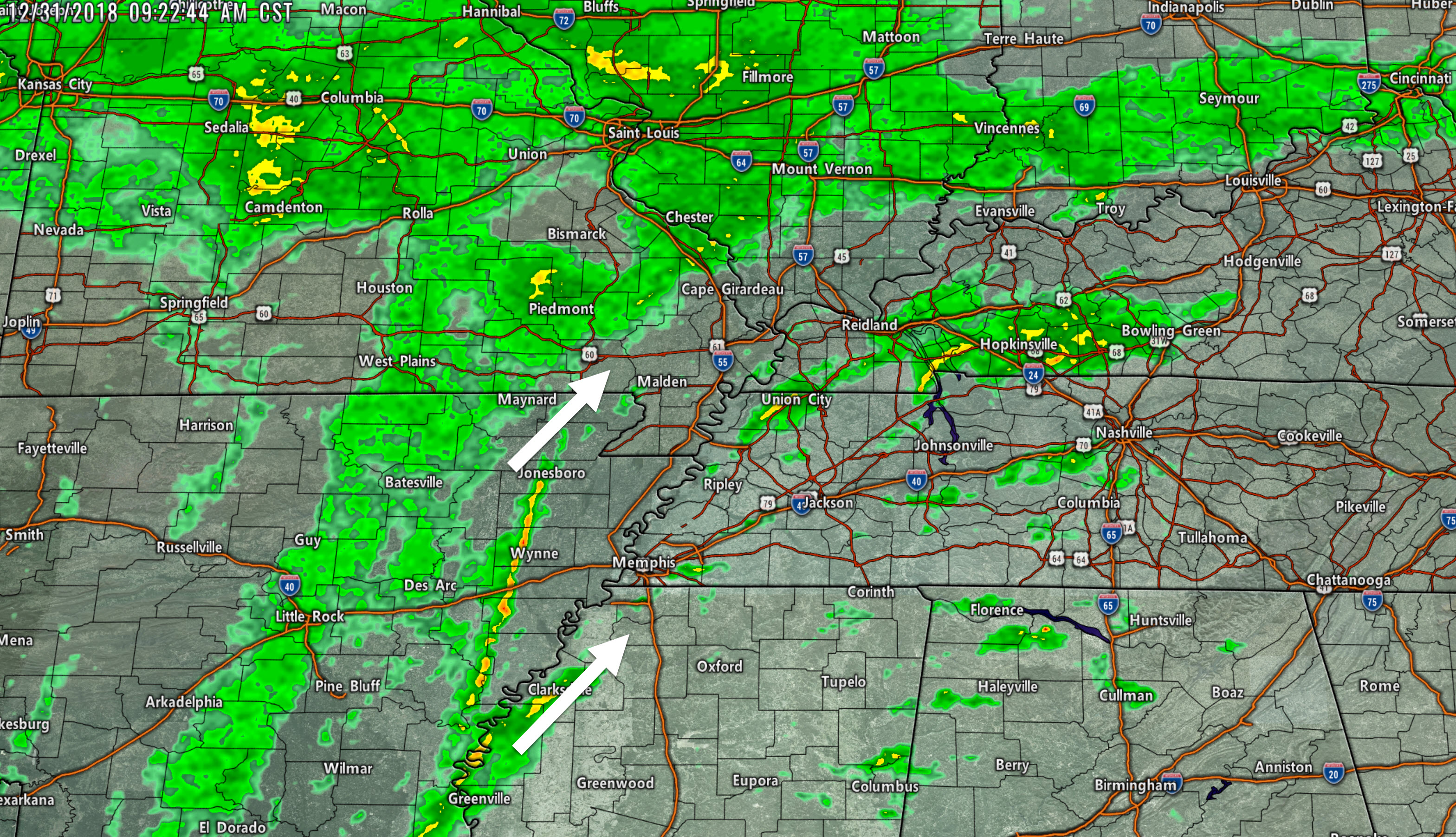
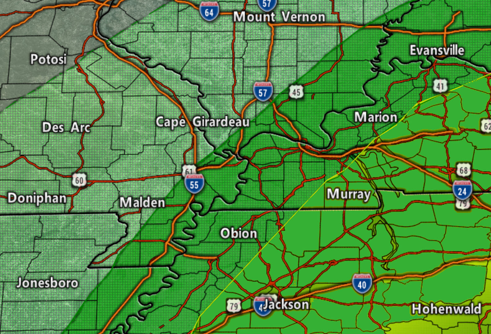
The main area of concern will be the darker green zones. That would include southeast Illinois, western Kentucky, western Tennessee, and the Missouri Bootheel.
Areas to the right of the yellow line may have a slightly better chance of severe weather. Either way, the main concern will be damaging wind gusts with a line of thunderstorms. A tornado can’t be ruled out in bowing line segments or any storms that form ahead of the main line of storms.
The light green zone would mainly be where lightning is possible.
A cold front is positioned to our west. A warm front is passing through the region.
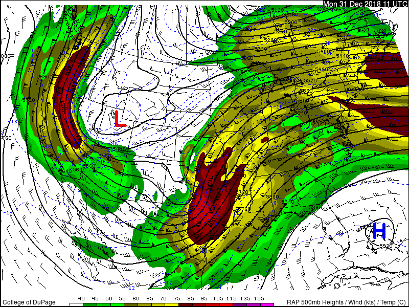
The jet stream is racing across our region today. The low-level jet will approach 80+ mph later this morning into this afternoon. The upper-level jet will be roaring overhead, as well. All of this wind energy will help produce the potential of damaging wind gusts and tornadoes.
Here is the 850 mb map. This is about 5000′ aloft. These are strong winds.
Wind shear the turning of winds with height or the increase of wind speed with height will be present today. Wind shear is one ingredient when forecasting severe thunderstorms.
No shortage of wind energy today.

Here is the 300 mb jet stream map.

Here is the 500 mb jet stream map
Warm and moist air is streaming northward from the Gulf of Mexico.
The warmest weather today will be across portions of southern Illinois into Kentucky and Tennessee.
Temperatures will pop into the lower to middle 60’s ahead of the cold front.
Dew points will also be on the rise. Dew point is a measure of moisture in the atmosphere. The higher dew points will help set the stage for thunderstorms.
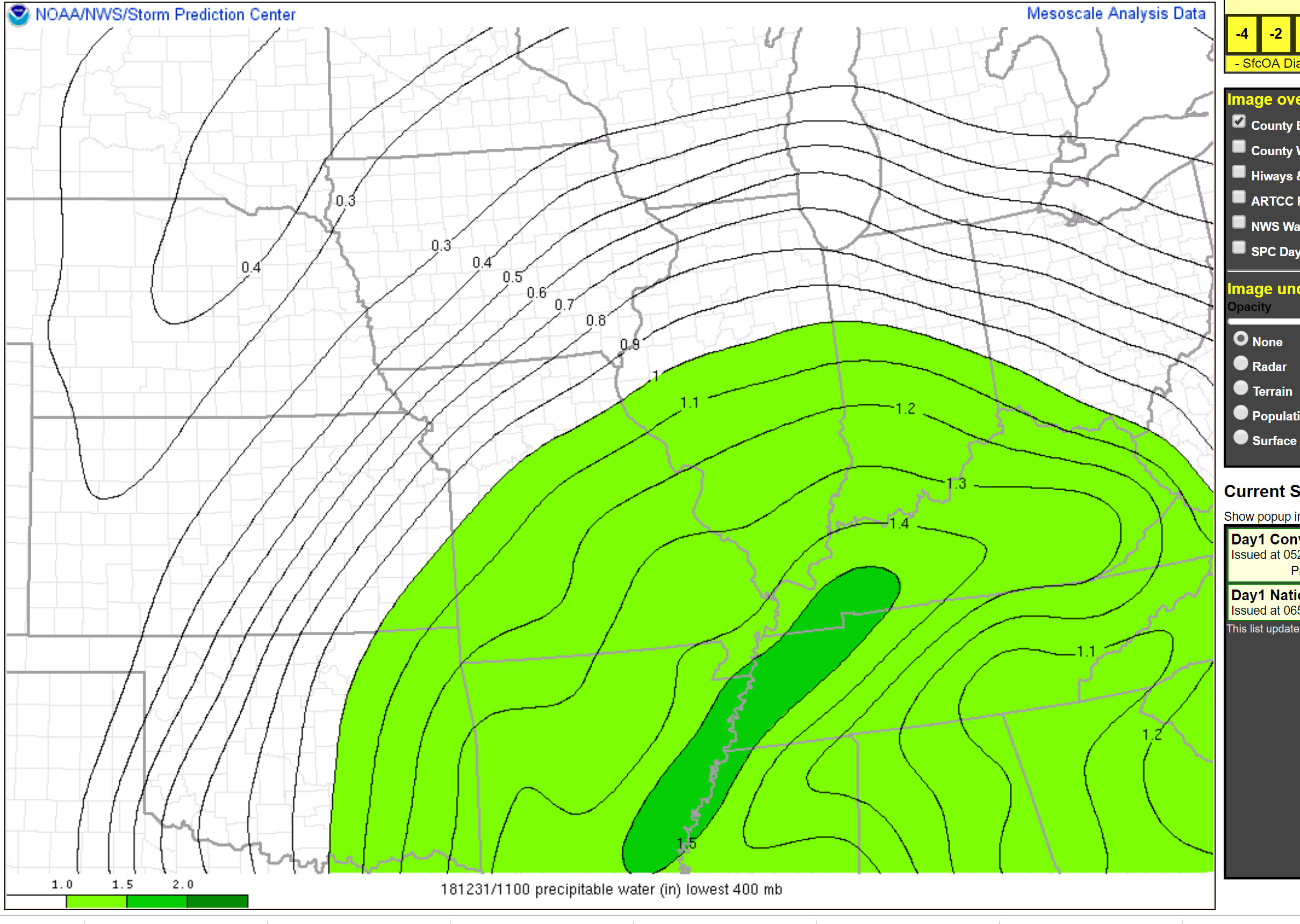
PWAT values are high for this time of the year. There is no shortage of moisture for thunderstorms to tap into.
Here is the morning PWAT value map. These are well above the seasonal norms.
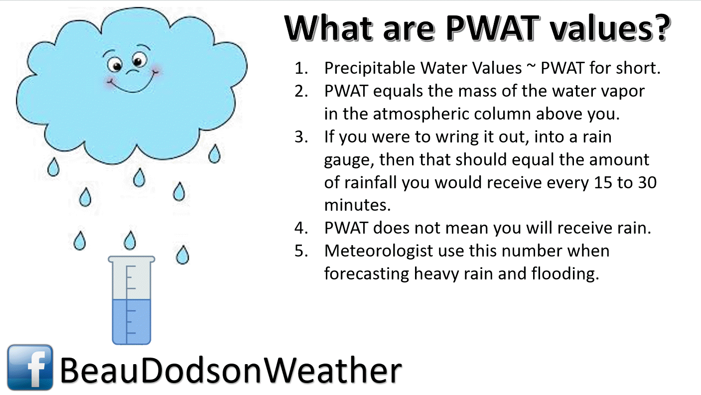
7 AM PWAT values
Check out the temperature animation for today.
A warm surge of air ahead of the cold front. That will help set the stage for our thunderstorms.
Dew points will also be on the rise today. I generally look for 58+ dew points when forecasting severe weather. Portions of our region will have those numbers today.

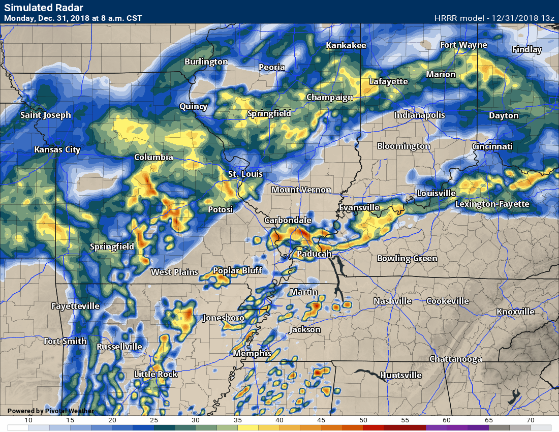
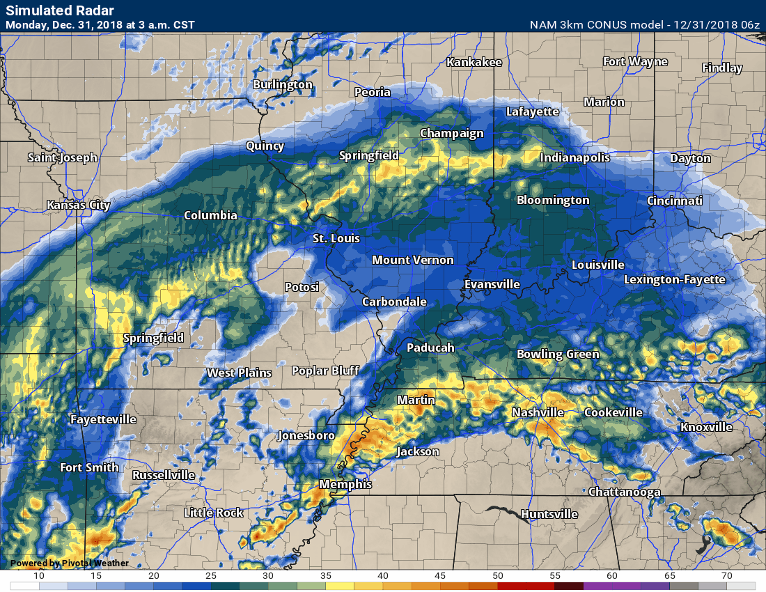
Future-cast radar from the 3K NAM model guidance. You can see the formation of a line of storms later today. That is called a QLCS.
These lines can produce high winds and isolated tornadoes.
Time-stamp upper left.
Here is the high resolution Hrrr model guidance for today.
We will dry out late Monday afternoon into Monday night. The precipitation should be over before sunset Monday.
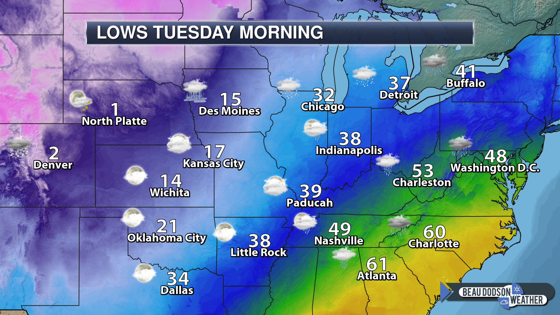
It will be colder Tuesday morning.
Monday highs

Tuesday morning lows
Tuesday

Wednesday morning lows
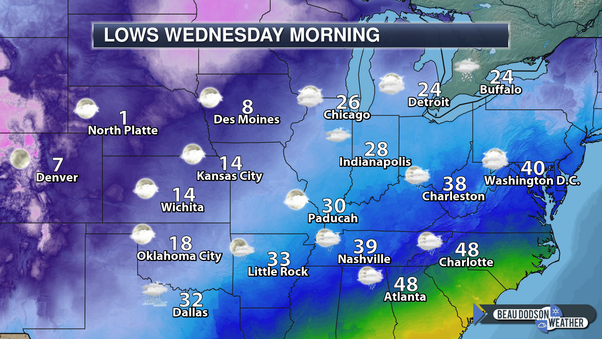
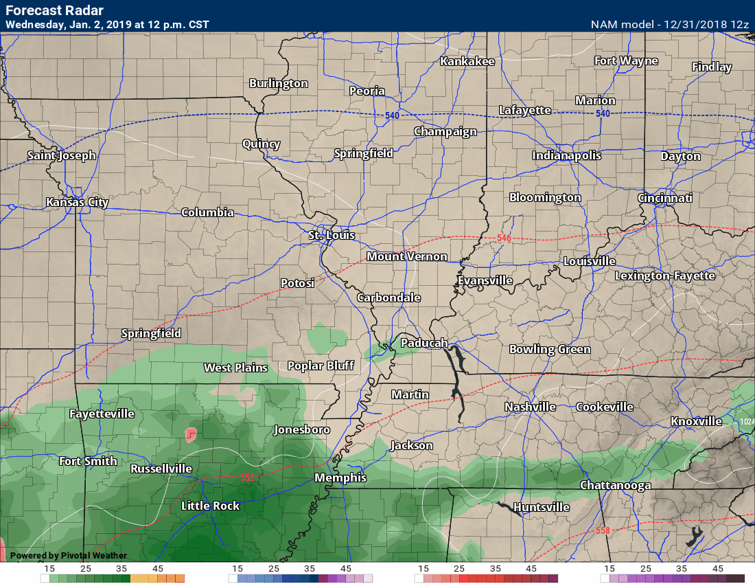
Tuesday into Friday
Dry conditions return Monday night into Wednesday morning.
Our next precipitation maker
Many models are showing the Wednesday into Friday event as mostly rain. This remains a possibility. Confidence isn’t all that great in the final details. Continue to monitor updates.
Questions in the forecast begin Wednesday into Friday as another system develops to our southwest.
I am closely monitoring a southern storm system that will bring rain and perhaps a wintry mix south of our region.
Some of the guidance is showing copious amounts of moisture with this event. The question will be the track of the low and upper-level low-pressure center. That will be key to our regions forecast.
Most of the guidance over the past 24 hours has brought precipitation into our region.
There has been a northward shift in all of the guidance packages. That does increase confidence that we will have some type of precipitation in our region Wednesday into Friday.
Perhaps the heaviest precipitation would be Thursday and Friday.
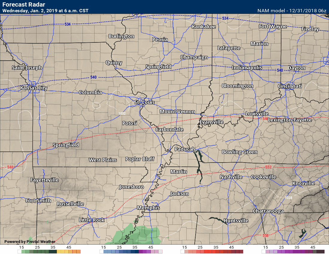
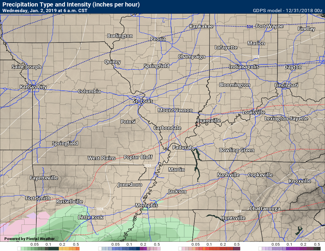
Here is the NAM guidance is showing. It does not go out far enough to cover the entire system.
First, here is the future-cast radar from the NAM guidance. One model of many.
Here are the temperatures via the NAM model.

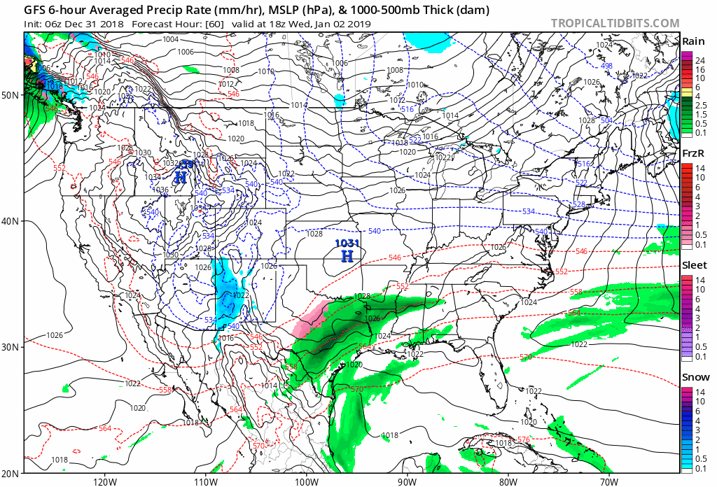
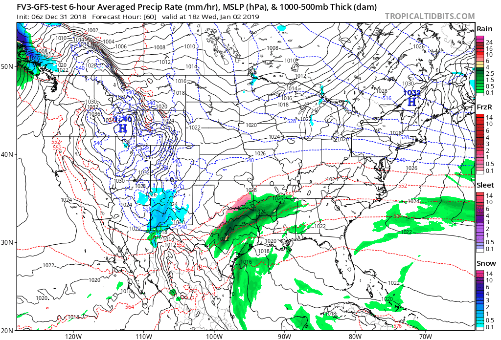
You can see it here on the GFS model guidance. The GFS has been trending northward.
There are two different GFS models. A new one will replace the old one soon.
This is the old version.
They both look similar.
Notice there is a wave of precipitation on Wednesday and Thursday. The bigger system then develops Thursday night into Friday.
You can see the blue colors. That represents snow. Green, dark green, yellow, and orange represent rain to heavy rain.
There remain questions above temperatures in our local area. The GFS would mostly be a wintry mix changing to rain.
A band of snow develops on the GFS from southwest Missouri into central Illinois Thursday night and Friday.
One model of many. All models show something a little bit different. Confidence will increase over the coming 48 to 72 hours on a final solution.
Here is the new version of the GFS. Not much different from the old version.
Here is the Canadian model.
The Canadian model is colder vs the GFS. It shows more of a wintry mix and snow solution locally.
The EC model shows mostly rain in our region. It keeps snow to our west.
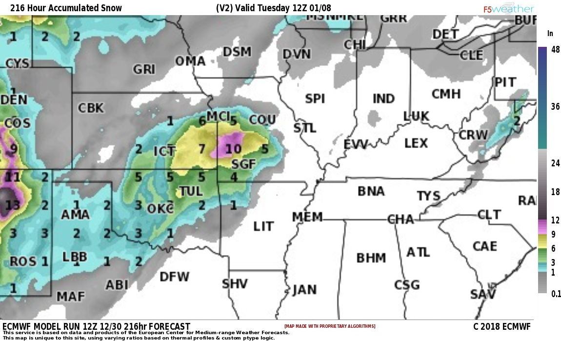
This is the EC model snow totals forecast.
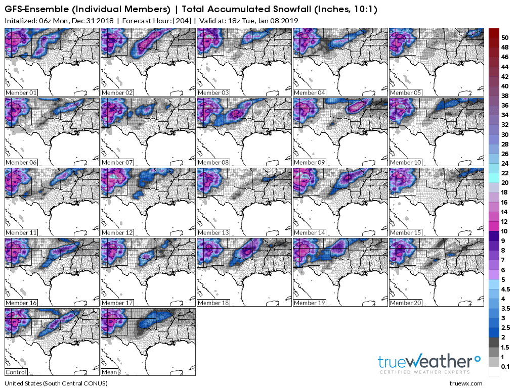
Let me show you some ensemble guidance.
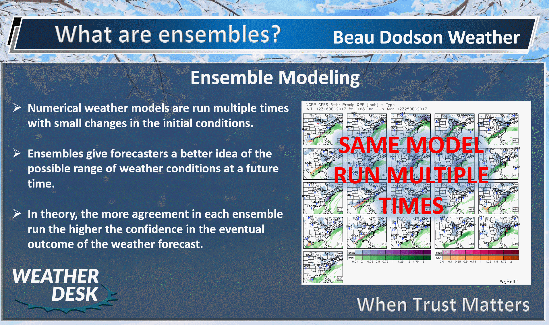
Here are the GFS ensembles
There has been a move towards two waves of precipitation. On Wednesday night/Thursday and a bigger push Thursday night and Friday. This is a change from previous forecast updates.
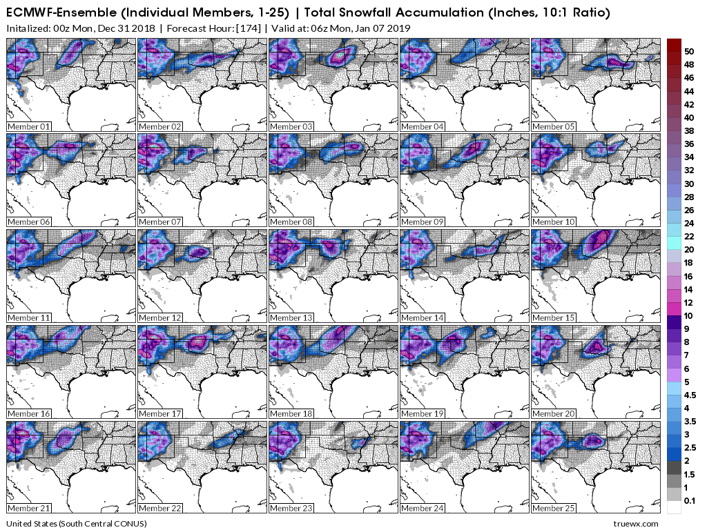
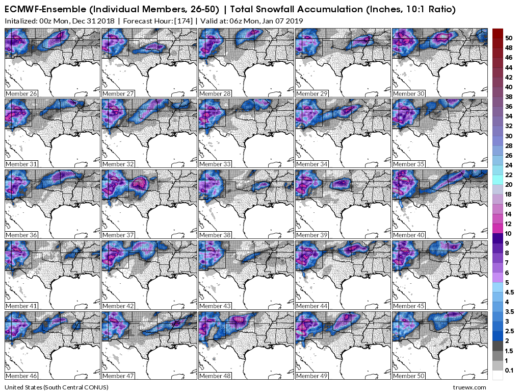
Temperatures remain a question mark. We could see a wintry mix changing to all rain. Confidence in the details will remain low.
Click to enlarge
Some of them are showing snow in our region Wednesday night into Thursday night. The colors represent snow totals.
Again, the idea is to see if there is an agreement in the ensembles..
Some show snow locally and some do not.
There remains a lower than normal confidence in the Wednesday through Friday time-frame.
Here are the EC model ensembles. Another model.
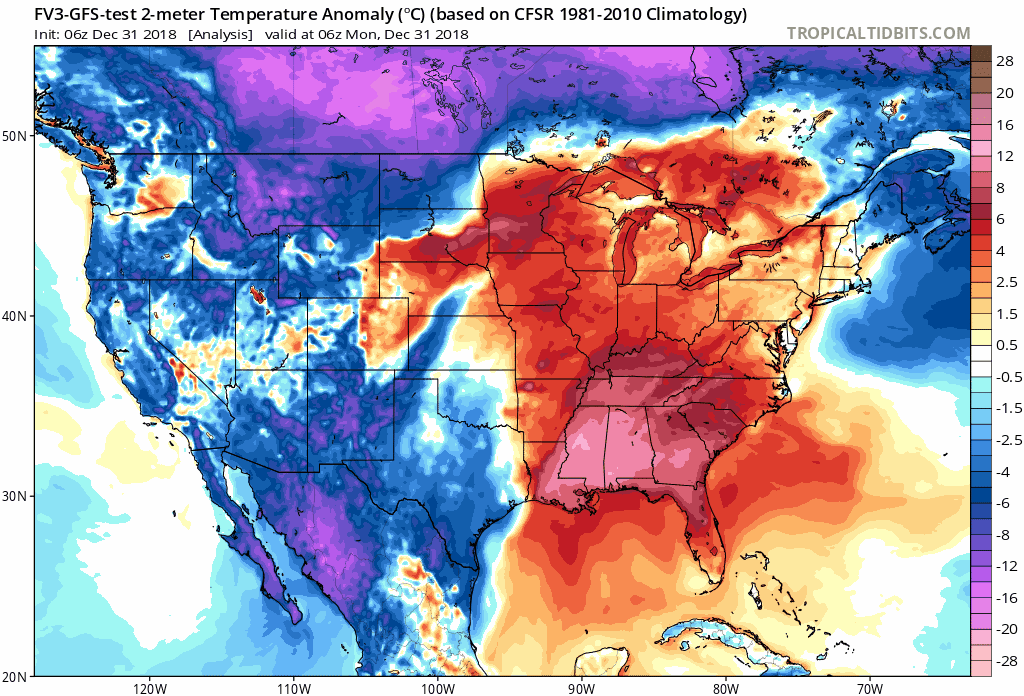
Temperature Anomalies
Let’s look at the temperature anomaly forecast map from the GFS model guidance.
I will keep showing you this graphic animation over the coming weeks.
Red colors indicate above normal temperatures. Blue colors represent below normal temperatures.
The time-stamp is located in the upper left portion of the map animation.
The models have been swinging back and forth on the subject of warm vs cold.
Click to enlarge. Date stamp upper left.
![]()
Subscriber Bonus VIDEO UPDATES
These are bonus videos and maps for subscribers. I bring these to you from the BAMwx team. I pay them to help with videos.
The Ohio and Missouri Valley videos cover most of our area. They do not have a specific Tennessee Valley forecast but may add one in the future.
The long-range video is technical. Over time, you can learn a lot about meteorology from the long range video. Just keep in mind, it is a bit more technical.
NOTE: THESE ARE USUALLY NOT UPDATED ON SATURDAY OR SUNDAY.

See videos at www.weathertalk.com and click the video tab

See videos at www.weathertalk.com and click the video tab

See videos at www.weathertalk.com and click the video tab
![]()

I bring these to you from the BAMwx team. They are excellent long-range forecasters.
Remember, long-range outlooks are always going to be a lower confidence level than short-term forecasts. It is not an exact science. There are many variables that determine the eventual outcome of a long-range forecast.

Normal high temperatures for this time of the year are around 44 degrees.
Normal low temperatures for this time of the year are around 26 degrees.
Normal precipitation during this time period ranges from 0.60″ to 0.80″
This outlook covers December 27th through December January 2nd
Click images to enlarge them.
Will be updated on Wednesday
The precipitation forecast is PERCENT OF NORMAL. For example, if your normal rainfall is 1.00″ and the graphic shows 10%, then that would mean 0.10″ of rain is anticipated.
Will be updated on Wednesday

Normal high temperatures for this time of the year are around 42 degrees
Normal low temperatures for this time of the year are around 25 degrees
Normal precipitation during this time period ranges from 0.40″ to 0.80″
This outlook covers January 3rd through January 9th
Will be updated on Wednesday
Will be updated on Wednesday
The precipitation forecast is PERCENT OF NORMAL. For example, if your normal rainfall is 1.00″ and the graphic shows 10%, then that would mean 0.10″ of rain is anticipated.
Will be updated on Wednesday

Will be updated on Wednesday
Outlook definitions
EC = Equal chances of above or below normal
BN= Below normal
M/BN = Much below normal
AN = Above normal
M/AN = Much above normal
E/AN = Extremely above normal
Normal high temperatures for this time of the year are around 42 degrees
Normal low temperatures for this time of the year are around 22 degrees
Normal precipitation during this time period ranges from 1.00″ to 1.80″
This outlook covers January 10th and January 23rd
Will be updated on Wednesday
The precipitation forecast is PERCENT OF NORMAL. For example, if your normal rainfall is 1.00″ and the graphic shows 10%, then that would mean 0.10″ of rain is anticipated.
Will be updated on Wednesday
![]()

The winter update has been posted.
I always tell people to read this
http://johndee.com/seasonalfcst/soapbox.htm
Winter forecasts are some skill and some luck. The science is far from perfect.
January temperature outlook graphic
Will be updated on Wednesday
January temperature outlook
Will be updated on Wednesday
December through February snow outlook.
The long range team indicates above normal snowfall likely.
Will be updated on Wednesday
Technical details
Click to enlarge
Will be updated on Wednesday
![]()
January temperature outlook
Will be updated on Wednesday
February temperature outlook
Will be updated on Wednesday
March Temperature Outlook
Will be updated on Wednesday
![]()

A new weather podcast is now available! Weather Geeks (which you might remember is on The Weather Channel each Sunday)
To learn more visit their website. Click here.
![]()

WeatherBrains Episode 675
Tonight’s Guest WeatherBrain is the Warning Coordination Meteorologist at the Storm Prediction Center. Since 1996, he has performed as a severe weather, fire weather, mesoscale, and lead forecaster at the SPC. Greg Carbin, welcome to the show!
Also joining us as Guest Panelist is the Lead Forecaster at the Storm Prediction Center, Rich Thompson. Welcome to WeatherBrains!
Other discussions in this weekly podcast include topics like:
- What really happens during a government shutdown?
- More hurricane-related fatalities in 2018 than tornado-related fatalities
- 2018 Hurricane Michael’s aftermath largely ignored by national media?
- Probability of seeing a Day 3 Convective Outlook “High Risk”
- and more!
Link to their website https://weatherbrains.com/
Previous episodes can be viewed by clicking here.
We offer interactive local city live radars and regional radars. If a radar does not update then try another one. If a radar does not appear to be refreshing then hit Ctrl F5. You may also try restarting your browser.
The local city view radars also have clickable warnings.
During the winter months, you can track snow and ice by clicking the winterize button on the local city view interactive radars.
You may email me at beaudodson@usawx.com
Find me on Facebook!

Find me on Twitter!

Did you know that a portion of your monthly subscription helps support local charity projects?
You can learn more about those projects by visiting the Shadow Angel Foundation website and the Beau Dodson News website.

I encourage subscribers to use the app vs regular text messaging. We have found text messaging to be delayed during severe weather. The app typically will receive the messages instantly. I recommend people have three to four methods of receiving their severe weather information.
Remember, my app and text alerts are hand typed and not computer generated. You are being given personal attention during significant weather events.
