
.
Beau’s Daily forecast
.
Sunday Night Forecast Details:
Forecast: Quite a few clouds. Mild for December. Becoming windy.
Temperatures: MO ~ 48 to 54 IL ~ 46 to 52 KY ~ 48 to 54
Wind chill values: N/A
Accumulating snow or ice: No
Winds: South and southeast at 6 to 12 mph with gusts to 25 mph
What impacts are anticipated from the weather? None
My confidence in the forecast verifying: High
Is severe weather expected? No
The NWS defines severe weather as 58 mph wind or great, 1″ hail or larger, and/or tornadoes
Is freezing rain, sleet, or snow expected? No
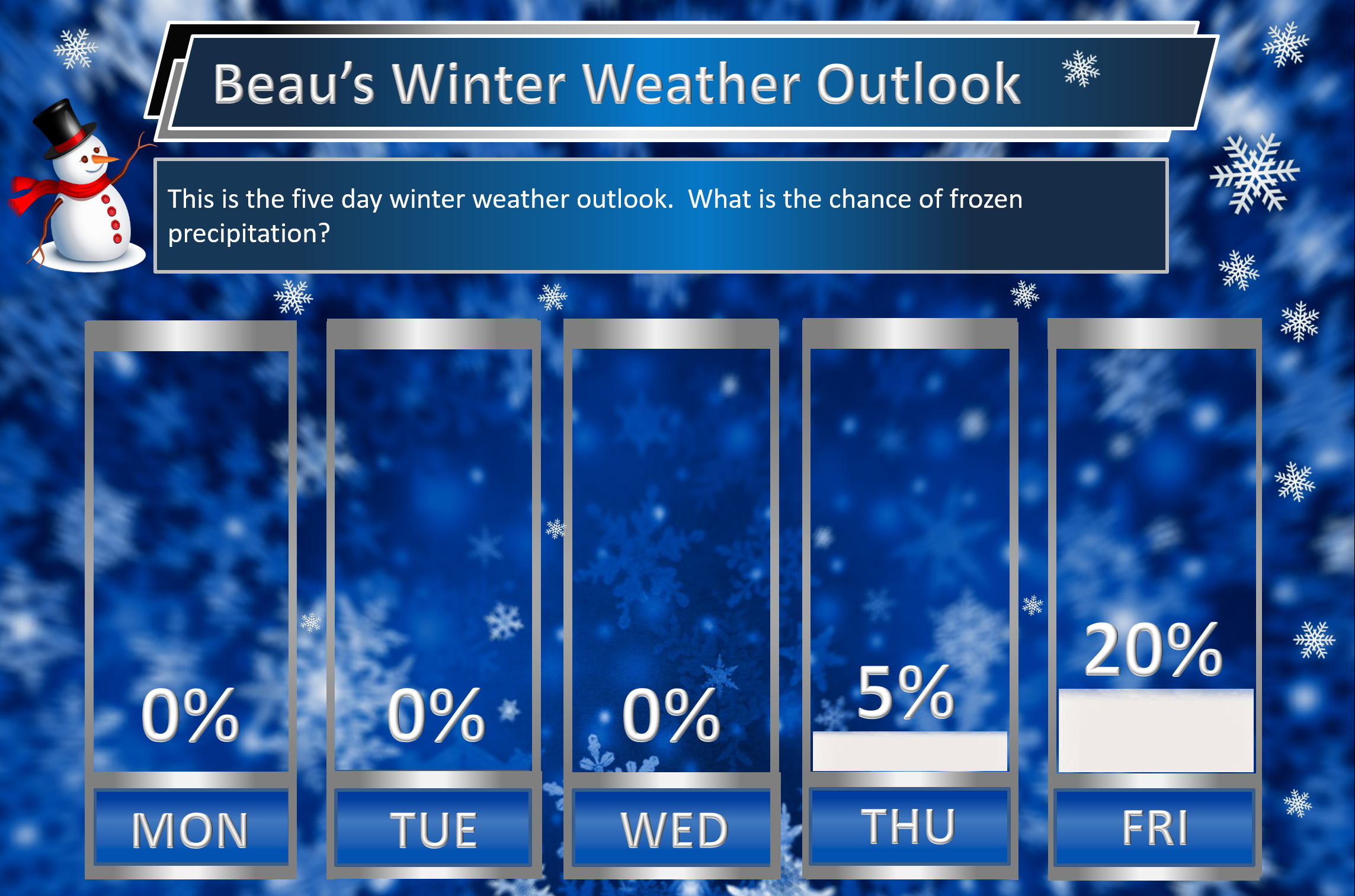
What is the chance of precipitation? MO ~ 0% IL ~ 0% KY ~ 0%
Coverage of precipitation: Most likely none
Should I cancel my outdoor plans: No
.
December 4, 2017
Monday Forecast Details
Forecast: Partly sunny. Warm for December. Gusty winds. Increasing clouds through the day. Isolated showers or thunderstorms possible during the afternoon hours.
Temperatures: MO ~ 65 to 70 IL ~ 65 to 70 KY ~ 65 to 70
Wind chill values: N/A
Accumulating snow or ice: No
Winds: Southerly at 15 to 35 mph and gusty.
What impacts are anticipated from the weather? Afternoon patchy wet roadways. Lightning.
My confidence in the forecast verifying: High
Is severe weather expected? No
The NWS defines severe weather as 58 mph wind or great, 1″ hail or larger, and/or tornadoes
Is freezing rain, sleet, or snow expected? No
What is the chance of precipitation? MO ~ 30% IL ~ 20% KY ~ 20%
Coverage of precipitation: Isolated
Should I cancel my outdoor plans? No
.
Monday Night Forecast Details:
Forecast: Cloudy and windy. Widespread showers and thunderstorms developing from west to east. Locally heavy downpours possible. A few storms could produce gusty winds. Falling temperatures as a late night cold front shifts from west to east. Mild before 12 am and then falling temperatures behind the cold front.
Temperatures: MO ~ 40 to 45 IL ~ 40 to 45 KY ~ 42 to 46
Wind chill values: N/A
Accumulating snow or ice: No
Winds: Southwest at 10 to 20 mph with gusts to 35 mph. Winds becoming west and northwest behind the cold front at speeds of 15 to 30 mph.
What impacts are anticipated from the weather? Wet roadways. Lightning. Locally heavy downpours.
My confidence in the forecast verifying: High
Is severe weather expected? A few storms could be strong. Strong winds would be the primary concern.
The NWS defines severe weather as 58 mph wind or great, 1″ hail or larger, and/or tornadoes
Is freezing rain, sleet, or snow expected? No
What is the chance of precipitation? MO ~ 90% IL ~ 95% KY ~ 95%
Coverage of precipitation: Widespread
Should I cancel my outdoor plans: Have a plan B.
.
December 5, 2017
Tuesday Forecast Details
Forecast: Cloudy before noon. A few remaining showers before 10 am (mainly over the Pennyrile area of western Kentucky). Showers will have ended from west to east. Temperatures holding steady or slowly falling. Breezy, at times.
Temperatures: MO ~ 45 to 50 with falling temps possible IL ~ 45 to 50 with falling temps possible KY ~ 45 to 50 with falling temps possible
Wind chill values: N/A
Accumulating snow or ice: No
Winds: West and northwest at 10 to 25 mph. Gusty.
What impacts are anticipated from the weather? Wet roadways early.
My confidence in the forecast verifying: High
Is severe weather expected? No
The NWS defines severe weather as 58 mph wind or great, 1″ hail or larger, and/or tornadoes
Is freezing rain, sleet, or snow expected? No
What is the chance of precipitation? MO ~ 30% IL ~ 40% KY ~ 50%
Coverage of precipitation: Ending
Should I cancel my outdoor plans? Early morning plans may be interrupted by rain.
.
Tuesday Night Forecast Details:
Forecast: Decreasing clouds. A few passing clouds. Much colder.
Temperatures: MO ~ 24 to 28 IL ~ 24 to 28 KY ~ 24 to 28
Wind chill values: 16 to 24
Accumulating snow or ice: No
Winds: West at 5 to 10 mph with gusts to 15 mph early.
What impacts are anticipated from the weather? Most likely none. Perhaps patchy fog.
My confidence in the forecast verifying: Medium
Is severe weather expected? No
The NWS defines severe weather as 58 mph wind or great, 1″ hail or larger, and/or tornadoes
Is freezing rain, sleet, or snow expected? No
What is the chance of precipitation? MO ~ 0% IL ~ 0% KY ~ 0%
Coverage of precipitation: None
Should I cancel my outdoor plans: No
.
December 6, 2017
Wednesday Forecast Details
Forecast: Mostly sunny and colder.
Temperatures: MO ~ 40 to 45 IL ~ 42 to 46 KY ~ 44 to 48
Wind chill values: 30 to 40
Accumulating snow or ice: No
Winds: West and southwest at 5 to 10 mph with gusts to 15 mph
What impacts are anticipated from the weather? None
My confidence in the forecast verifying: High
Is severe weather expected? No
The NWS defines severe weather as 58 mph wind or great, 1″ hail or larger, and/or tornadoes
Is freezing rain, sleet, or snow expected? No
What is the chance of precipitation? MO ~ 0% IL ~ 0% KY ~ 0%
Coverage of precipitation: None anticipated
Should I cancel my outdoor plans? No
.
Wednesday Night Forecast Details:
Forecast: Clear to partly cloudy and colder.
Temperatures: MO ~ 23 to 26 IL ~ 23 to 26 KY ~ 24 to 26
Wind chill values: 15 to 23
Accumulating snow or ice: No
Winds: West and northwest winds at 5 to 10 mph
What impacts are anticipated from the weather? Most likely none
My confidence in the forecast verifying: High
Is severe weather expected? No
The NWS defines severe weather as 58 mph wind or great, 1″ hail or larger, and/or tornadoes
Is freezing rain, sleet, or snow expected? No
What is the chance of precipitation? MO ~ 0% IL ~ 0% KY ~ 0%
Coverage of precipitation: None
Should I cancel my outdoor plans: No
.
December 7, 2017
Thursday Forecast Details
Forecast: Partly cloudy. Cold. A slight chance of a snow flurry.
Temperatures: MO ~ 35 to 40 IL ~ 35 to 40 KY ~ 36 to 44
Wind chill values: 22 to 34
Accumulating snow or ice: No
Winds: West and northwest winds at 5 to 10 mph with gusts to 14 mph
What impacts are anticipated from the weather? None
My confidence in the forecast verifying: Medium
Is severe weather expected? No
The NWS defines severe weather as 58 mph wind or great, 1″ hail or larger, and/or tornadoes
Is freezing rain, sleet, or snow expected? No
What is the chance of precipitation? MO ~ 10% IL ~ 10% KY ~ 10%
Coverage of precipitation: Most likely none. Isolated flurries possible.
Should I cancel my outdoor plans? No
.
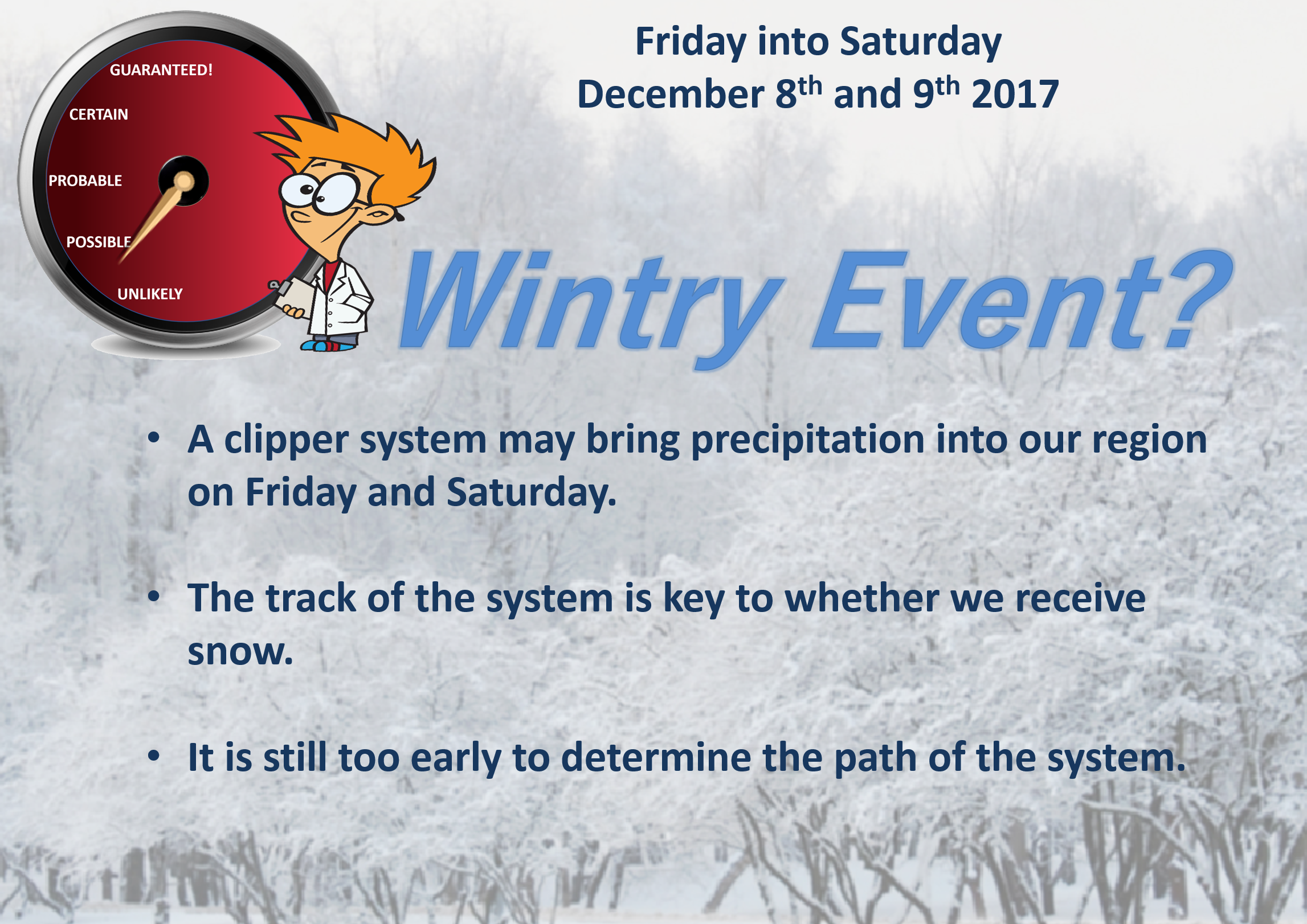
The track of two storm systems on Thursday through Saturday will be the key to whether someone in our local area receives a few snowflakes. Too early to know the exact path of the systems. Monitor updates.
.
Thursday Night Forecast Details:
Forecast: Increasing clouds. A 30% of snow showers. Cold.
Temperatures: MO ~ 18 to 24 IL ~ 18 to 24 KY ~ 20 to 25
Wind chill values: 10 to 18
Accumulating snow or ice: Monitor updates
Winds: Variable winds at 7 to 14 mph
What impacts are anticipated from the weather? Monitor updates. Cold wind chills.
My confidence in the forecast verifying: LOW
Is severe weather expected? No
The NWS defines severe weather as 58 mph wind or great, 1″ hail or larger, and/or tornadoes
Is freezing rain, sleet, or snow expected? Snow showers are possible
What is the chance of precipitation? MO ~ 30% IL ~ 30% KY ~ 30%
Coverage of precipitation: Scattered
Should I cancel my outdoor plans: Monitor updates
.
December 8, 2017
Friday Forecast Details
Forecast: Quite a few clouds. Snow showers possible.
Temperatures: MO ~ 34 to 38 IL ~ 34 to 38 KY ~ 34 to 38
Wind chill values: 20 to 30
Accumulating snow or ice: Monitor updates
Winds: West and southwest winds at 6 to 12 mph with gusts to 25 mph
What impacts are anticipated from the weather? Monitor updates.
My confidence in the forecast verifying: LOW
Is severe weather expected? No
The NWS defines severe weather as 58 mph wind or great, 1″ hail or larger, and/or tornadoes
Is freezing rain, sleet, or snow expected? Snow showers are possible
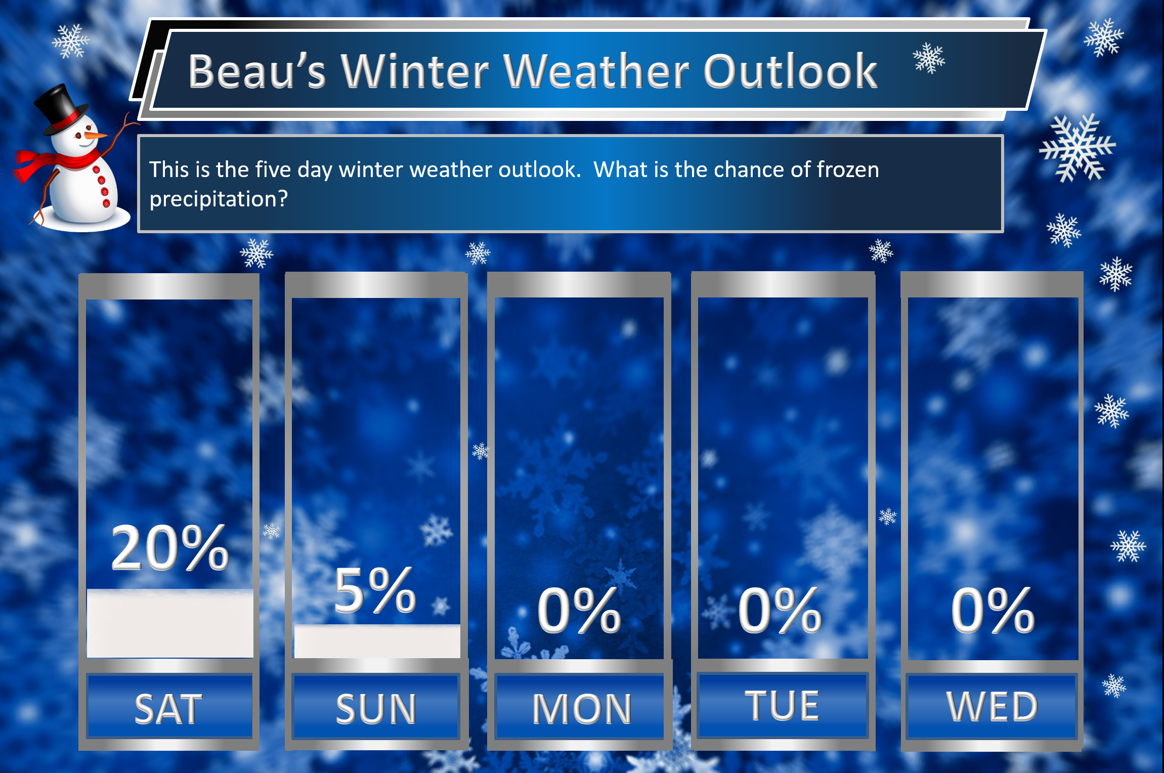
What is the chance of precipitation? MO ~ 30% IL ~ 30% KY ~ 30%
Coverage of precipitation: Scattered
Should I cancel my outdoor plans? Monitor updates
.
Friday Night Forecast Details:
Forecast: Quite a few clouds. Snow showers possible. Cold.
Temperatures: MO ~ 18 to 24 IL ~ 18 to 24 KY ~ 20 to 25
Wind chill values: 8 to 18
Accumulating snow or ice: Monitor updates
Winds: West and northwest winds at 7 to 14 mph. Gusty.
What impacts are anticipated from the weather? Monitor updates
My confidence in the forecast verifying: LOW
Is severe weather expected? No
The NWS defines severe weather as 58 mph wind or great, 1″ hail or larger, and/or tornadoes
Is freezing rain, sleet, or snow expected? Snow showers are possible
What is the chance of precipitation? MO ~ 30% IL ~ 30% KY ~ 30%
Coverage of precipitation: Scattered
Should I cancel my outdoor plans: Monitor updates
.
December 9, 2017
Saturday Forecast Details
Forecast: Quite a few clouds. Snow showers possible. Cold.
Temperatures: MO ~ 26 to 34 IL ~ 26 to 34 KY ~ 26 to 34
Wind chill values: 14 to 24
Accumulating snow or ice: Monitor updates
Winds: West and southwest winds at 6 to 12 mph with gusts to 18 mph
What impacts are anticipated from the weather? Monitor updates
My confidence in the forecast verifying: LOW
Is severe weather expected? No
The NWS defines severe weather as 58 mph wind or great, 1″ hail or larger, and/or tornadoes
Is freezing rain, sleet, or snow expected? Snow showers are possible
What is the chance of precipitation? MO ~ 30% IL ~ 30% KY ~ 30%
Coverage of precipitation: Scattered
Should I cancel my outdoor plans? Monitor updates. It will be quite cold.
.
Saturday Night Forecast Details:
Forecast: Clearing. Cold.
Temperatures: MO ~ 16 to 24 IL ~ 16 to 24 KY ~ 16 to 24
Wind chill values: 8 to 16 degrees
Accumulating snow or ice: No
Winds: North winds at 7 to 14 mph
What impacts are anticipated from the weather? None
My confidence in the forecast verifying: Medium
Is severe weather expected? No
The NWS defines severe weather as 58 mph wind or great, 1″ hail or larger, and/or tornadoes
Is freezing rain, sleet, or snow expected? Most likely none
What is the chance of precipitation? MO ~ 10% IL ~ 10% KY ~ 10%
Coverage of precipitation: Most likely none
Should I cancel my outdoor plans: No
.
December 10, 2017
Sunday Forecast Details
Forecast: Mostly sunny and cold.
Temperatures: MO ~ 36 to 42 IL ~ 35 to 40 KY ~ 36 to 42
Wind chill values: 15 to 25
Accumulating snow or ice: No
Winds: West and southwest winds at 6 to 12 mph with gusts to 18 mph
What impacts are anticipated from the weather? None
My confidence in the forecast verifying: Medium
Is severe weather expected? No
The NWS defines severe weather as 58 mph wind or great, 1″ hail or larger, and/or tornadoes
Is freezing rain, sleet, or snow expected? No
What is the chance of precipitation? MO ~ 10% IL ~ 10% KY ~ 10%
Coverage of precipitation: None
Should I cancel my outdoor plans? No
.
Sunday Night Forecast Details:
Forecast: Mostly clear. Cold.
Temperatures: MO ~ 24 to 28 IL ~ 24 to 28 KY ~ 24 to 28
Wind chill values: 20 to 24 degrees
Accumulating snow or ice: No
Winds: Light winds
What impacts are anticipated from the weather? None
My confidence in the forecast verifying: Medium
Is severe weather expected? No
The NWS defines severe weather as 58 mph wind or great, 1″ hail or larger, and/or tornadoes
Is freezing rain, sleet, or snow expected? None
What is the chance of precipitation? MO ~ 10% IL ~ 10% KY ~ 10%
Coverage of precipitation: None
Should I cancel my outdoor plans: No
.
December 3, 2017
1PM Update
Models continue to paint a windy 36 to 48 hours ahead of us. Plan on wind gusts above 20 mph on Sunday night and above 30 mph Monday into Monday night.
A line of showers and storms will push from west to east across the region on Monday afternoon (late) and especially Monday night into early Tuesday morning.
Some storms could be strong with gusty winds.
The big weather story will then be the colder temperatures on Tuesday into next week.
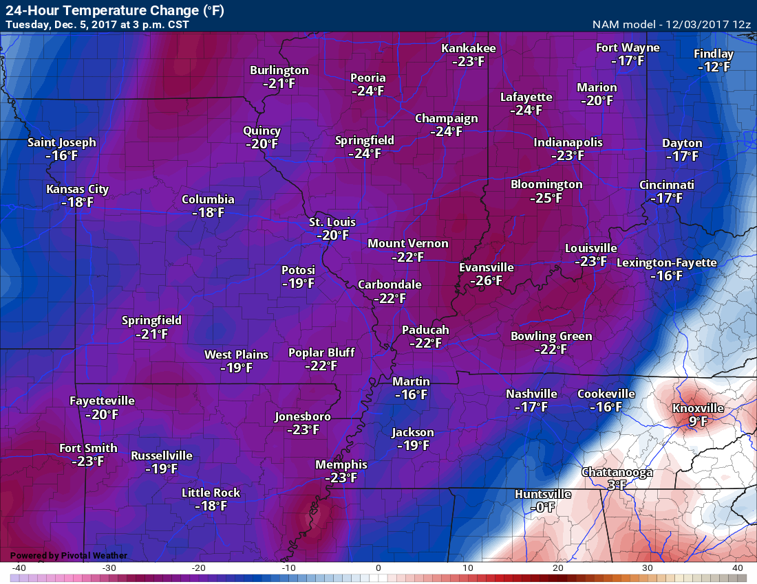
Check out this 24-hour temperature change map from 3 PM on Monday to 3 PM on Tuesday. Highs on Monday will rise into the upper 60’s. Temperatures on Tuesday will struggle to get out of the forties.
.
.
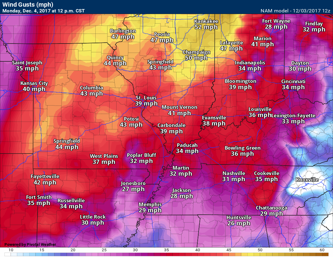
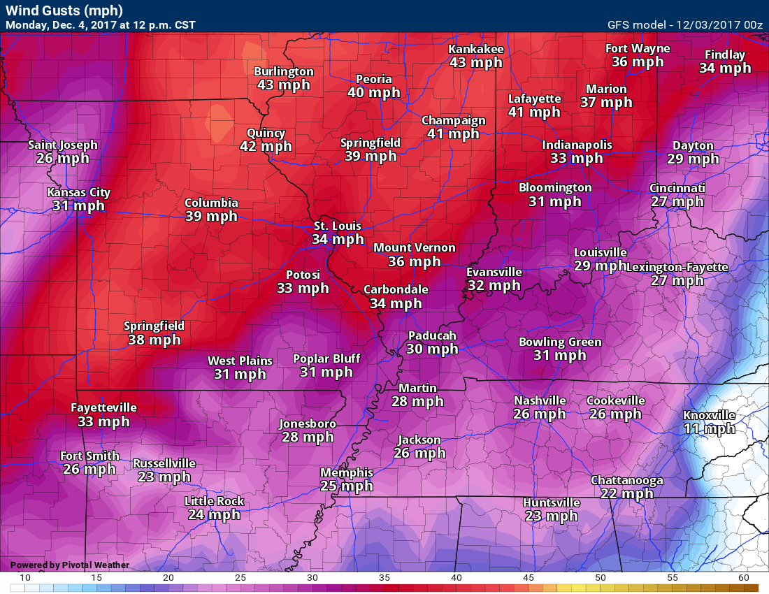
Here is the wind gust map for 12 PM on Monday. Strong and gusty winds.
.
The battle of the models continues. Snow or no snow later this week? That is the question.
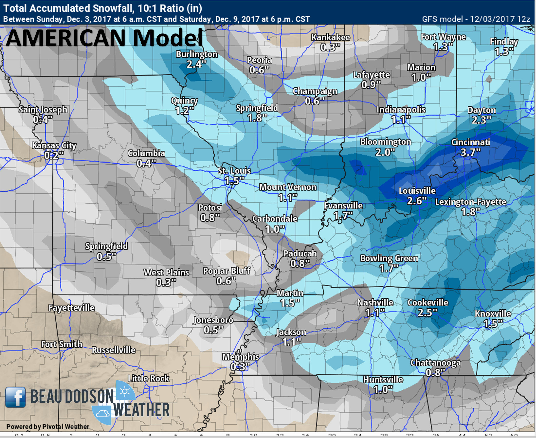
GFS model says snow
.
.
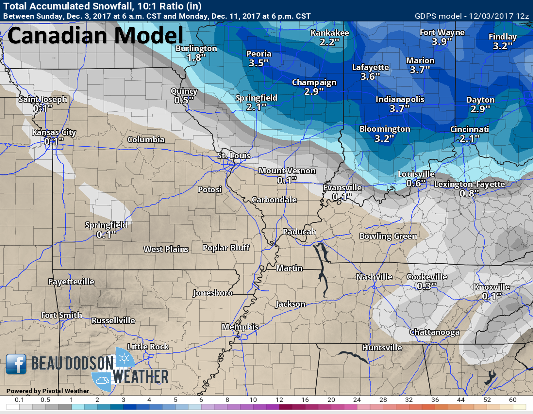
Canadian model says no snow
.
.
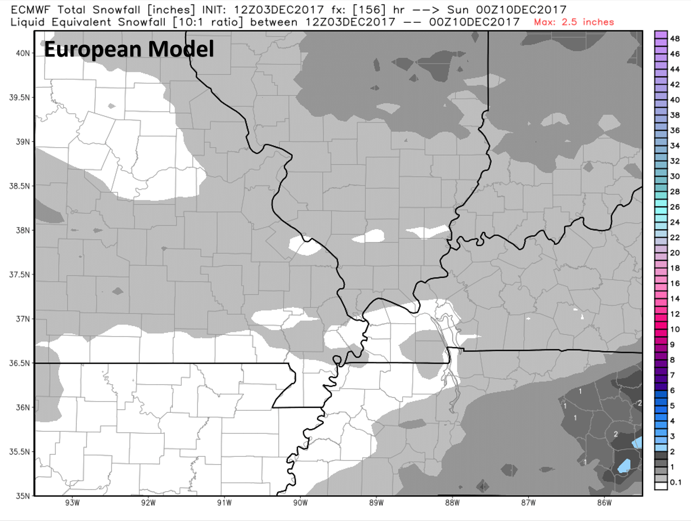
European model says snow flurries
.
.
.
Previous update below
This is a reminder that if you don’t subscribe to WeatherTalk, please do so. Average monthly costs (from my pocket) are between $1000 and $2000.00. You can subscribe at www.beaudodsonweather.com. Your subscription will allow you to receive app/text forecasts, alerts, social media posting alerts, and videos. It is only $3 per month. Also, please download the WeatherTalk app (it receives the same text messages but ten times faster).
.
Three weather stories over the coming days.
- Showers and perhaps some thunderstorms will arrive late Monday afternoon into Monday night.
- Much colder air arrives Wednesday into the following week
- Light snow events possible over the coming twelve days, but questions remain on the track of each system.
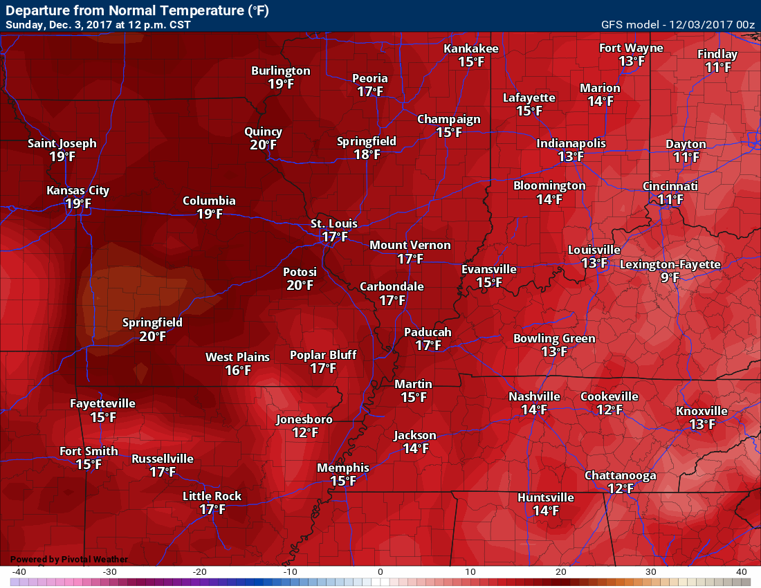
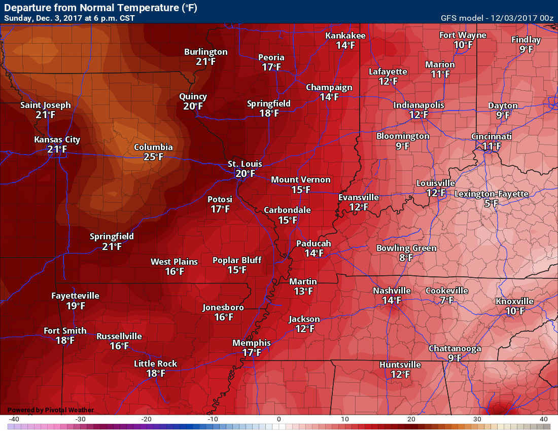
I think you are going to enjoy your Sunday weather forecast. Temperatures will be well above normal with highs in the 64 to 68-degree range. Normal high temperatures are in the upper 40’s to around 50 degrees.
Here is today’s temperature anomaly map. How many degrees above normal will temperatures be at 12 PM and 6 PM
.
.
6 PM
.
.
Enjoy this weather because it is not going to last.
Monday and Tuesday
A cold front will move into the area on Monday night and Tuesday. This front will be the start of dramatic weather changes for our local area.
Gusty winds will accompany the front. You can expect southerly winds ahead of the front in the 20 to 30 mph range. Higher gusts are possible.
Here is the GFS wind gust map for 12 PM on Monday.
.
.
Much colder air will start to arrive by Wednesday and we will stair step down into bitterly cold air by the weekend.
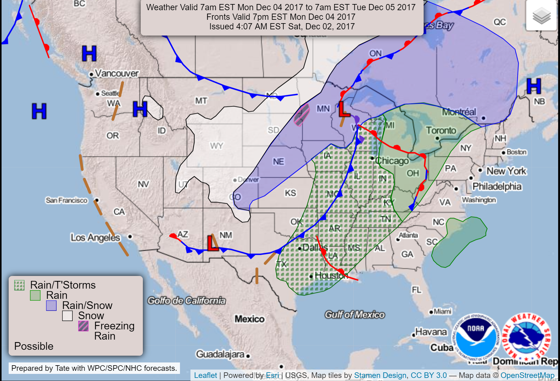
You can see the cold front on this WPC chart. This is at 7 PM on Monday.
.
.
Rain showers and thunderstorms will begin to develop in our region as early as Monday afternoon. Widespread showers and thunderstorms will develop by Monday night into early Tuesday morning.
A few of the thunderstorms could produce gusty winds. The severe weather risk is small.
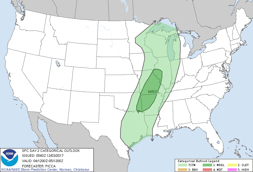
The Storm Prediction Center has outlined areas to our west in a marginal (level 1 out of 5) risk. Low-end risk. The light green is where thunderstorms may occur, but not anticipated to be severe. The dark green represents the marginal risk.
.
.
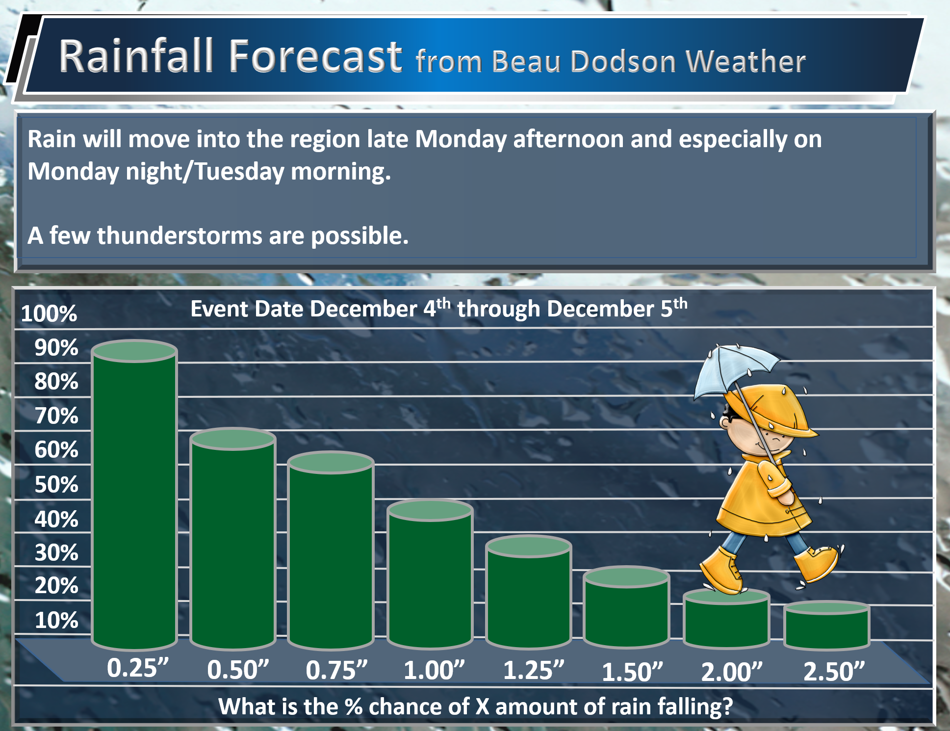
Here is my current rainfall forecast. This is the % chance for X amount of rain.
.
.
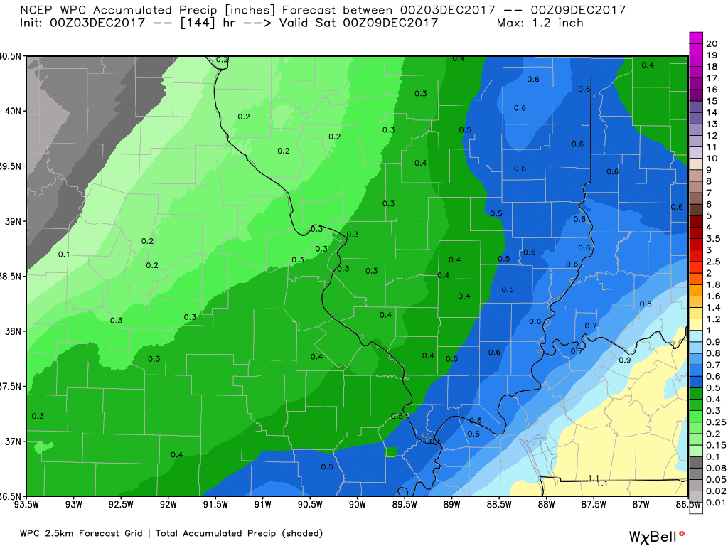
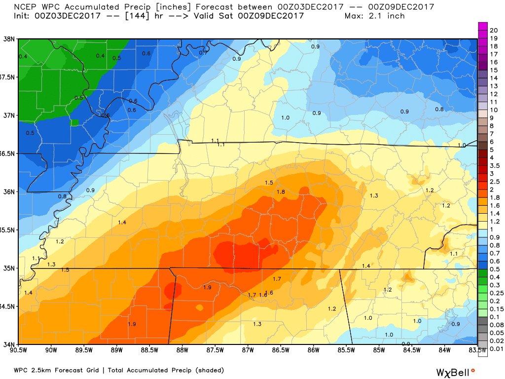
Here is the WPC/NOAA rainfall outlook.
You can click on the images to enlarge.
.
.
.
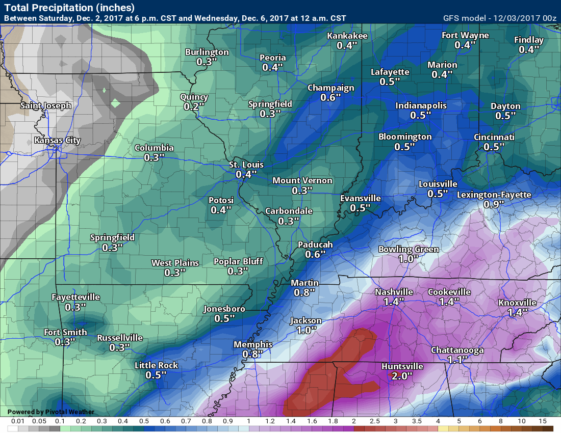
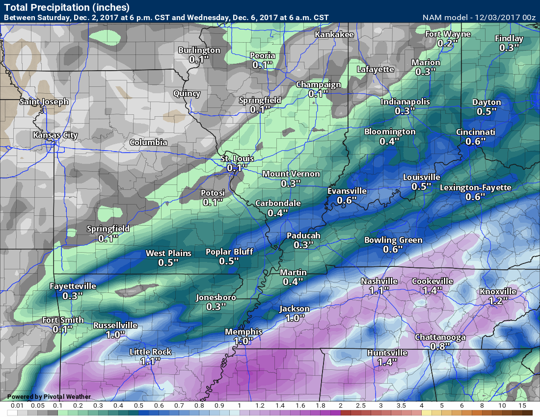
Model guidance indicates the potential for some locally heavy downpours. The risk is a bit higher for Kentucky and Tennessee vs Missouri and Illinois.
Models won’t be exact, but you get the idea.
.
GFS rainfall totals forecast
.
.
NAM rainfall totals forecast
.
.
Here is the future-cast radar from the NAM guidance. The time stamp is located on the top left of the image. Green represents rain. Yellow would be moderate rain.
.
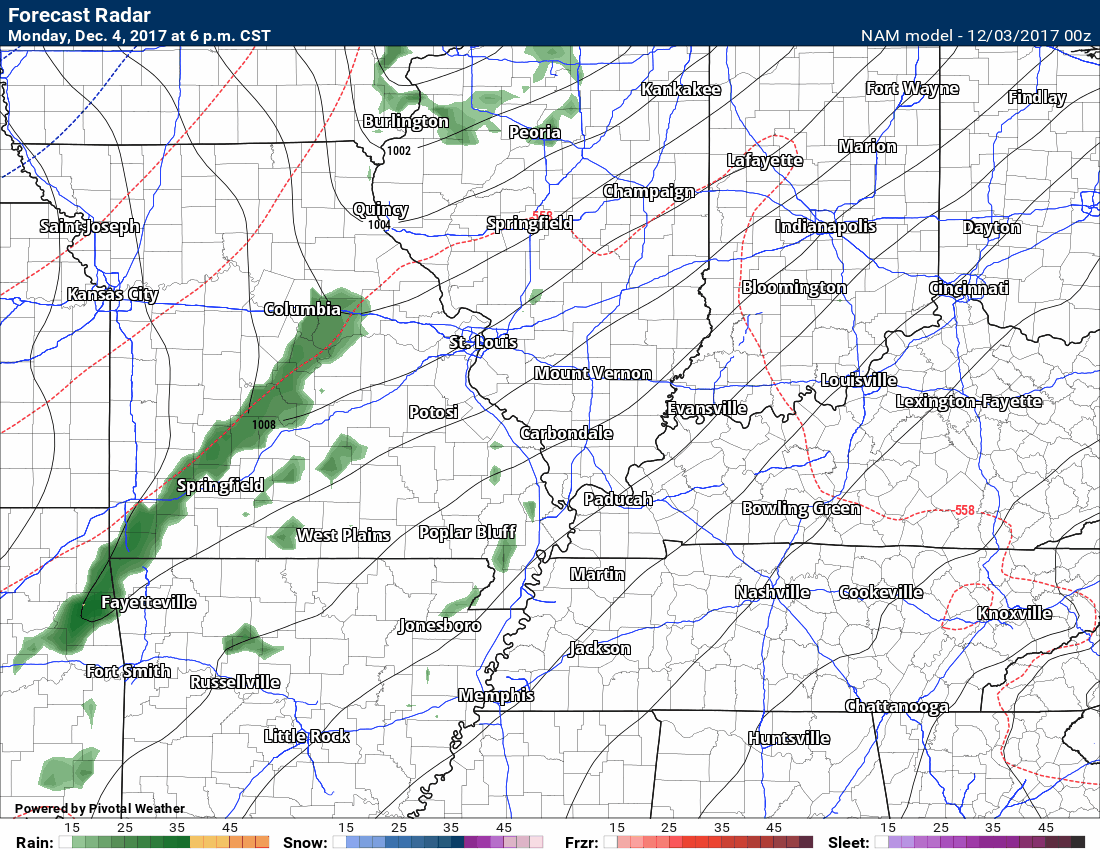
.
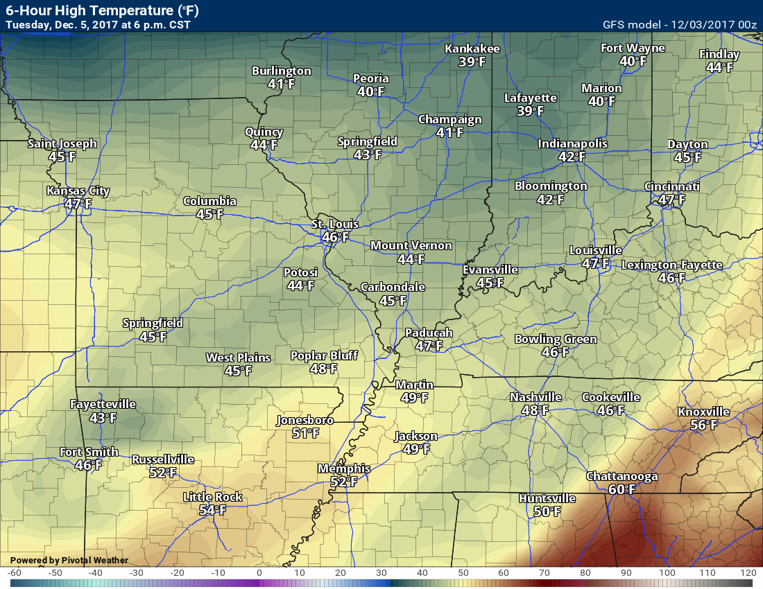
Rain should come to an end on Tuesday. Most of the rain should end before 12 pm.
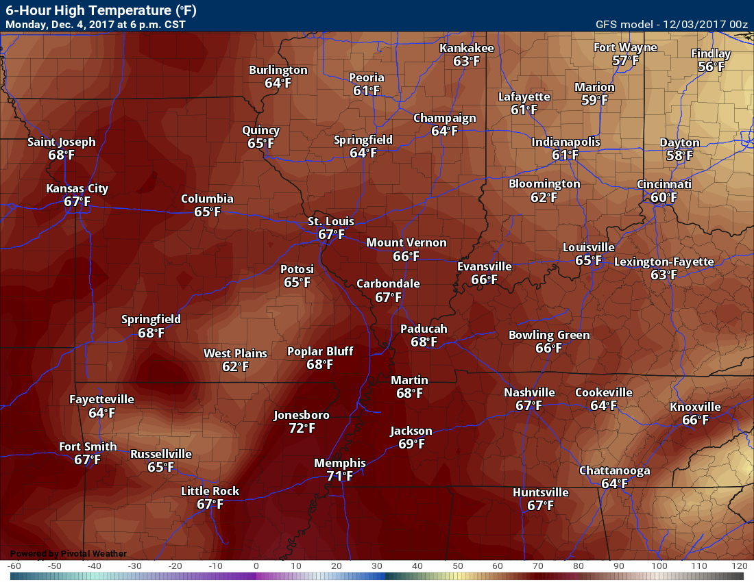
Temperatures on Tuesday will be somewhat cooler, but the coldest air will hold off until Wednesday onward.
Here is the GFS high temperature forecast for Monday
.
.
Tuesday 6 AM temperatures
.
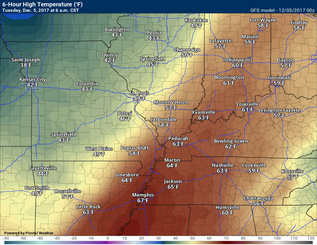
.
Tuesday high temperatures will be considerably cooler.
.
.
Wednesday high temperatures
.
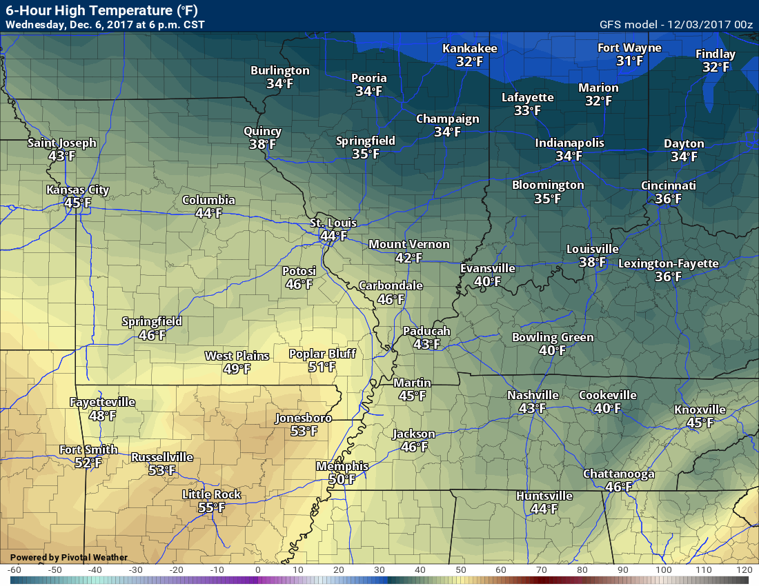
.
Thursday high temperatures
.
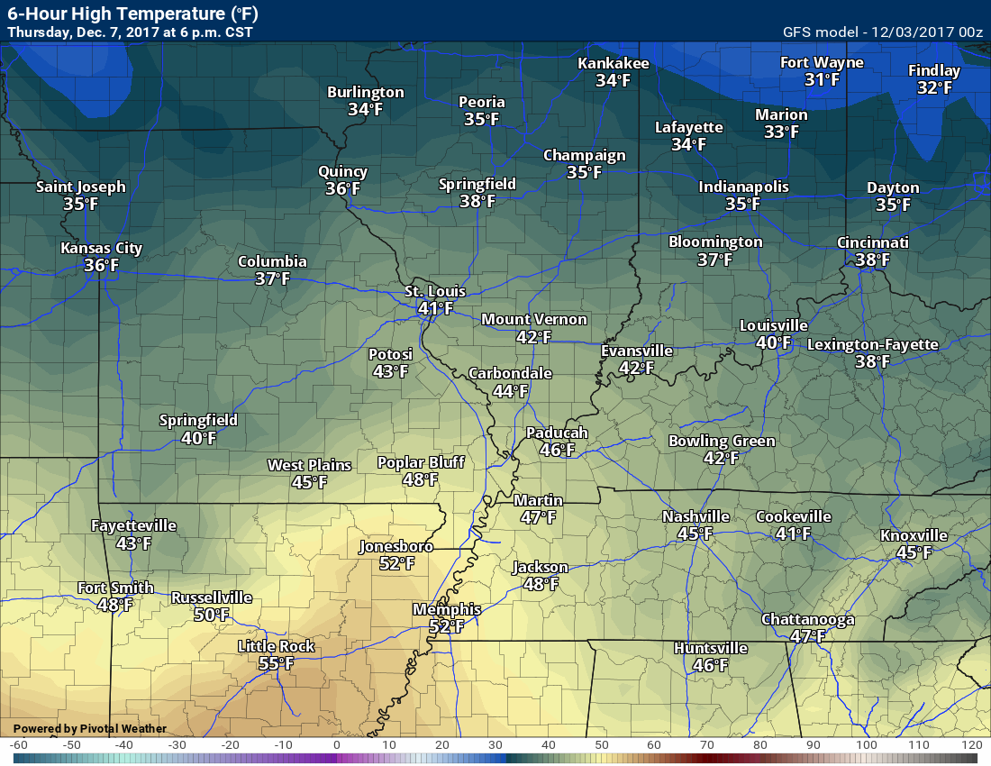
.
Friday high temperatures
.
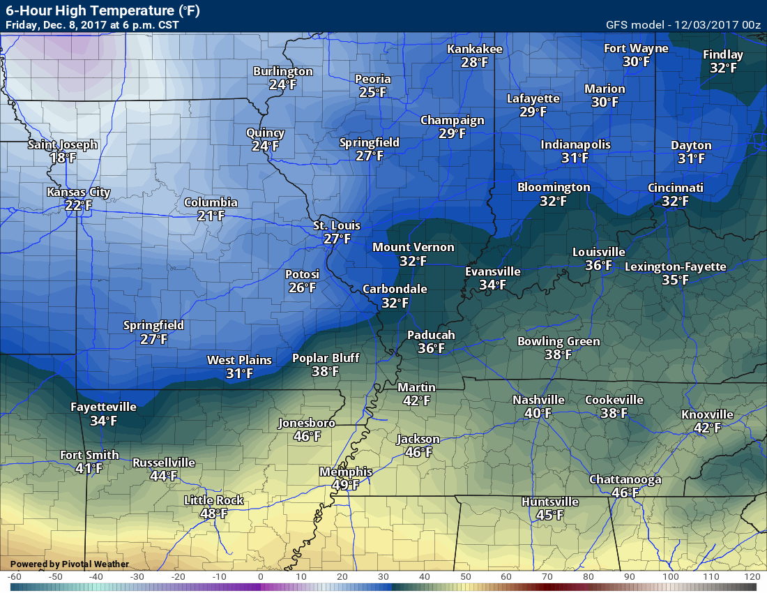
.
Saturday high temperatures
Woah. What happened on Saturday?
Snow. The GFS is painting snow over our local area. Whether snow falls or not is questionable.
Temperatures won’t be this cold without the snow.
.
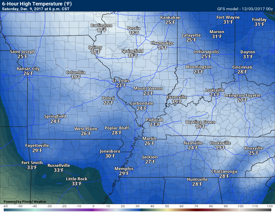
.
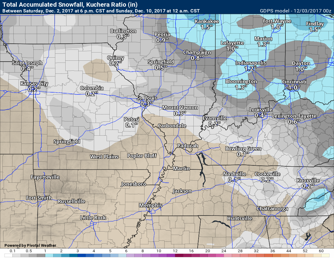
Let’s talk about the snow.
Snow probabilities have increased a bit from the previous update.
.
.
.
A clipper system will move into the Missouri and Ohio Valley on Thursday night into Saturday.
Clippers are fast moving systems that typically dive into the USA from Canada. They normally move east/southeast. They can occasionally bring snow into our area. Often times they stay to our north and northeast.
The timing of the clipper will need to be worked out. It is possible the system misses our local area.
Keep in mind, models do not handle snow all that well. We still have a few days to go before we will know if this system will impact our region.
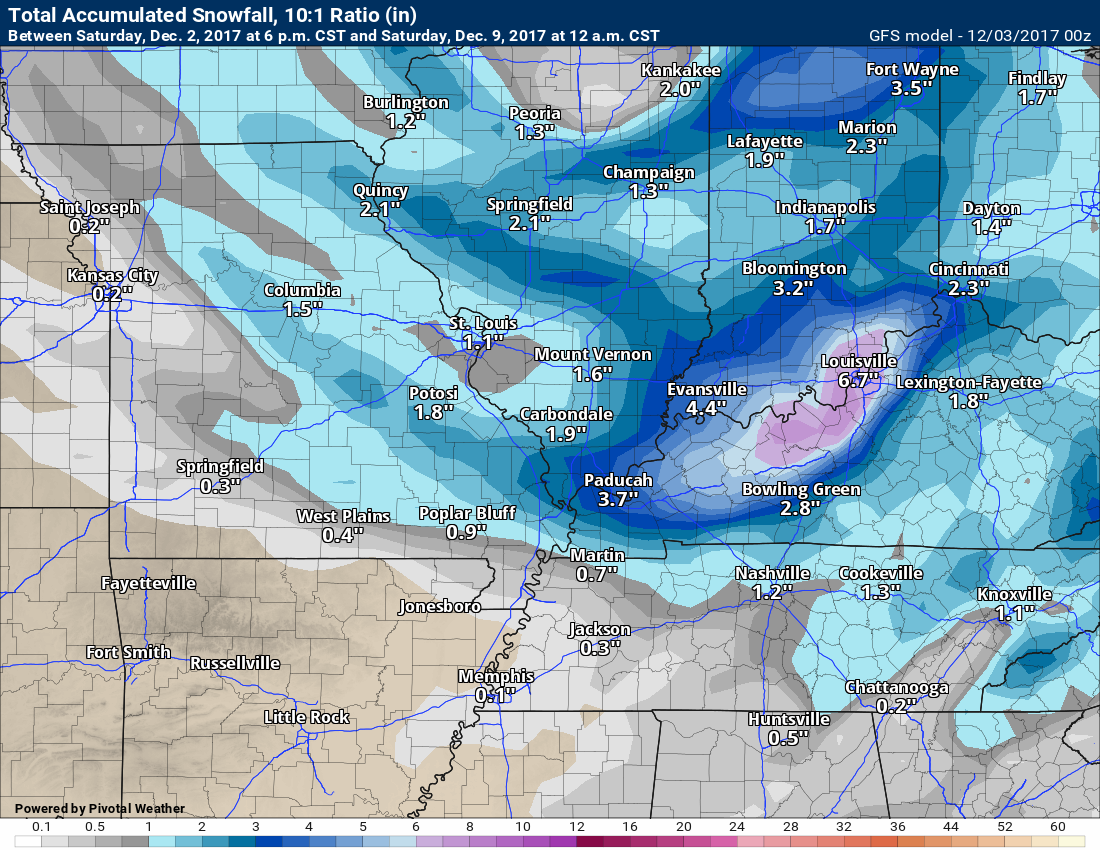
Here is what the GFS model is showing for snow totals.
The overnight run showed this
.
.
Previous runs of the GFS showed less snow and the system was further north.
The GFS model runs four times each day. The eventual track of the clipper is key to whether snow falls to our north or in our local area.
.
.
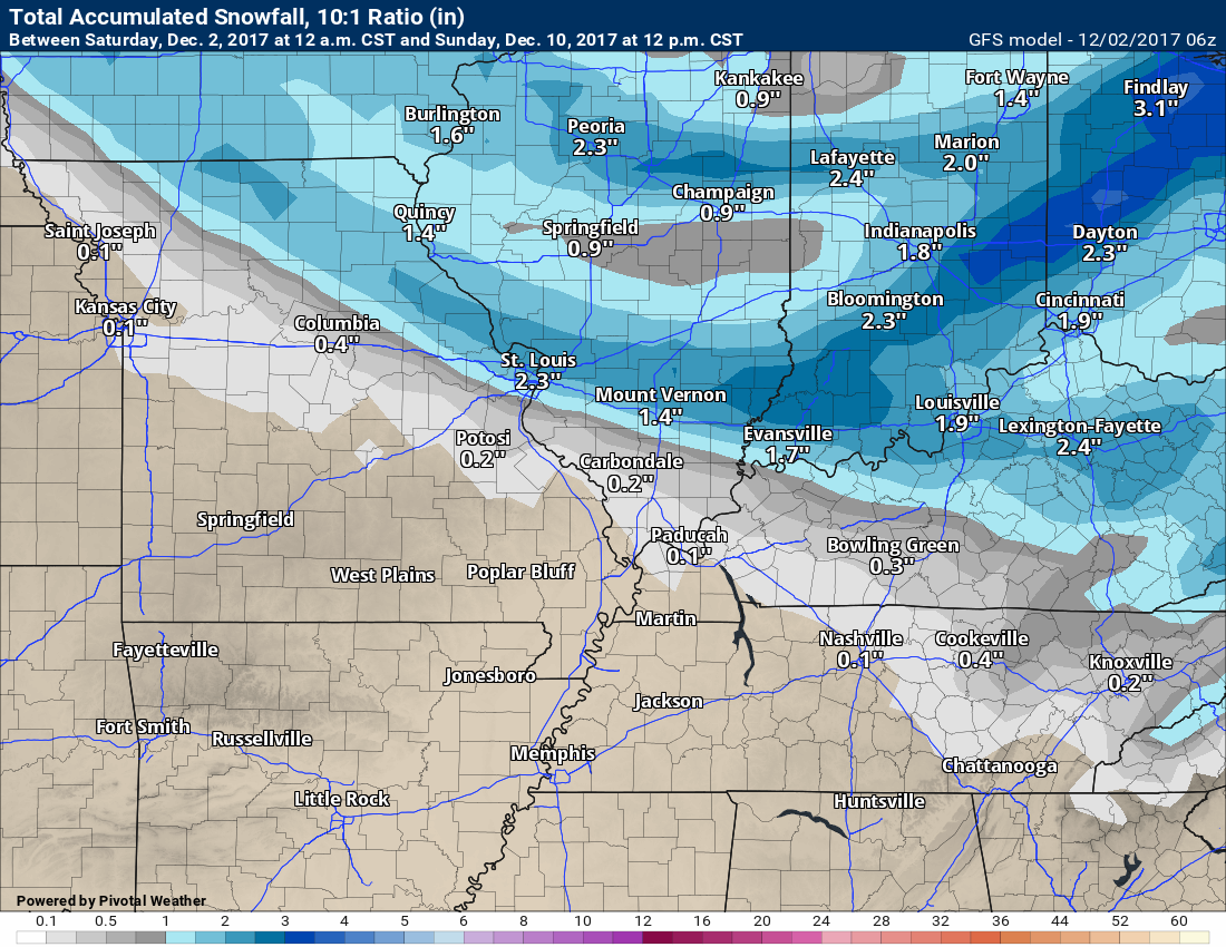
Meanwhile, the Canadian model (shown below) isn’t having it. It is showing almost no snow from the clipper.
.
.
Like always, snow systems in our region normally can’t be accurately forecast more than 24 to 48 hours in advance. We have some time to monitor this system.
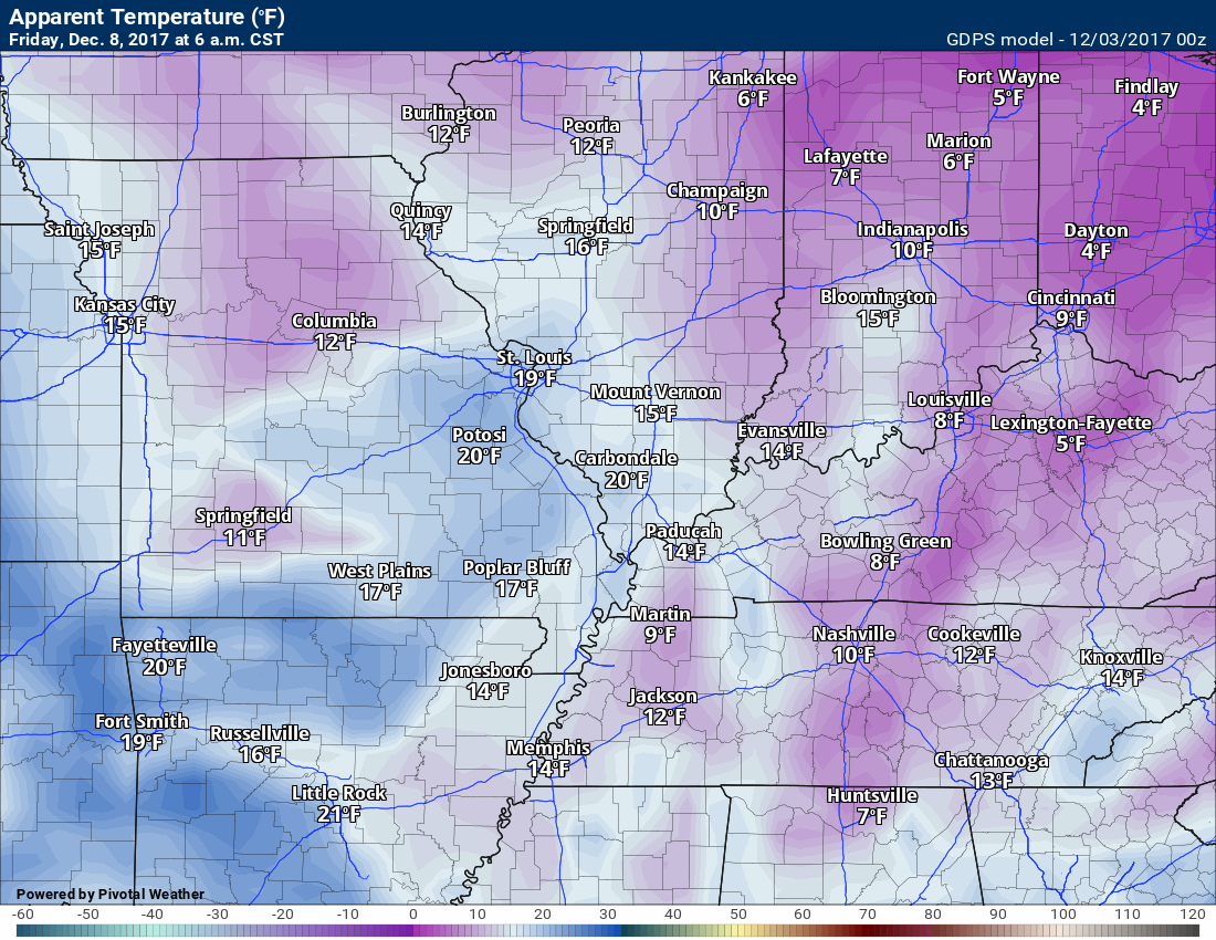
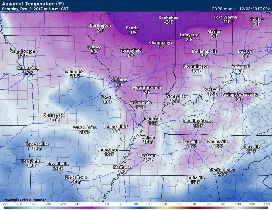
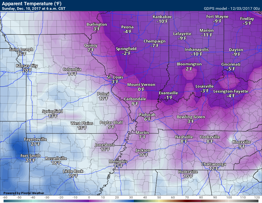
Bitterly cold wind chills are possible this coming weekend.
Friday 6 AM wind chills
.
.
Saturday 6 AM wind chills
.
.
Sunday 6 AM wind chills
The wind chills will be somewhat dependent on the snow. Either way, wind chills will likely be bitterly cold (with or without the snow).
.
.
Much colder air is moving into our region next week and the week after. Prepare for winter cold. Heating bills will be higher.
.

The previous update with the winter weather outlook can be viewed here http://talk.weathertalk.com/wp-admin/post.php?post=30174&action=edit