
WeatherTalk monthly operating costs can top $2000.00. Your $5 subscription helps pay for those costs. I work for you.
The $5 will allow you to register up to seven phones!
For $5 a month you can receive the following. You may choose to receive these via your WeatherTalk app or regular text messaging.
Severe weather app/text alerts from my keyboard to your app/cell phone. These are hand typed messages from me to you. During tornado outbreaks, you will receive numerous app/text messages telling you exactly where the tornado is located.
- Daily forecast app/texts from my computer to your app/cell phone.
- Social media links sent directly to your app/cell phone. When I update the blog, videos, or Facebook you will receive the link.
- AWARE emails. These emails keep you well ahead of the storm. They give you several days of lead time before significant weather events.
- Direct access to Beau via text and email. Your very own personal meteorologist. I work for you!
- Missouri and Ohio Valley centered video updates
- Long-range weather videos
- Week one, two, three and four temperature and precipitation outlooks.
Monthly outlooks. - Your subscription also will help support several local charities.
Would you like to subscribe? Subscribe at www.beaudodsonweather.com
Typical progression on a severe weather day for subscribers.


I encourage subscribers to use the app vs regular text messaging. We have found text messaging to be delayed during severe weather. The app typically will receive the messages instantly. I recommend people have three to four methods of receiving their severe weather information.
Remember, my app and text alerts are hand typed and not computer generated. You are being given my personal attention during significant weather events.

WWW.WEATHERTALK.COM subscribers, here is my day to day schedule for your weather products.
These are bonus videos and maps for subscribers. I bring these to you from the BAMwx team. I pay them to help with videos.
The Ohio and Missouri Valley videos cover most of our area. They do not have a specific Tennessee Valley forecast but may add one in the future.
The long-range video is technical. Over time, you can learn a lot about meteorology from the long range video. Just keep in mind, it is a bit more technical.


Subscribe at www.weathertalk.com
![]()

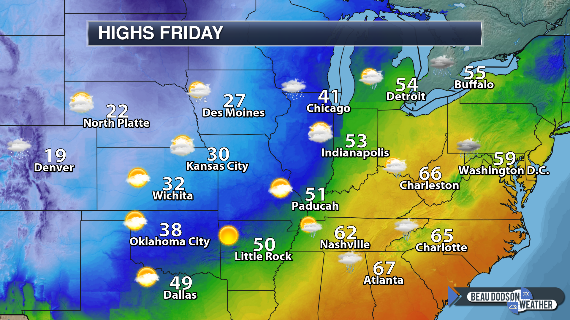
December 28, 2018
Friday Forecast: Intervals of clouds. Not as mild as it was on Thursday. Temperatures may fall during the day as colder air moves in from the west and northwest.
My confidence in the forecast verifying: Medium (60% confidence in the forecast)
Temperature range: MO ~ 40 to 45 IL ~ 42 to 48 KY ~ 50 to 55 TN ~ 50 to 55
Wind direction and speed: Becoming west and northwest at 7 to 14 mph and gusty
Wind chill (feels like) temperature forecast:
What is the chance/probability of precipitation? MO ~ 0% IL ~ 0% KY ~ 0% TN ~ 0%
Coverage of precipitation: None
Is flash flooding anticipated? No
Is accumulating snow or ice anticipated? No
Is non-accumulating snow or ice anticipated? No
Are icy road conditions anticipated? No
Is severe weather expected? No
The NWS officially defines severe weather as 58 mph wind or great, 1″ hail or larger, and/or tornadoes
Will lightning be possible? No
What impacts are anticipated from the weather? None
Should I cancel my outdoor plans? No
Will the weather impact my outdoor plans? It may be damp because of the Thursday and Thursday night rain event. Otherwise, no other impacts.
UV Index: 2 Low
Sunrise: 7:09 AM
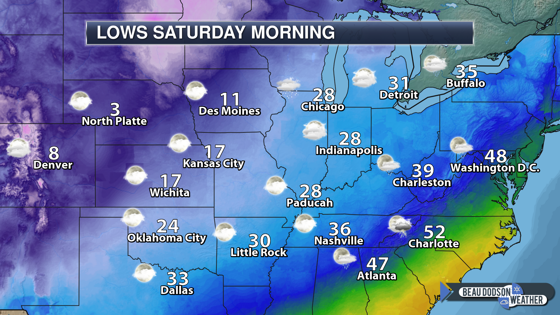
Friday Night Forecast Details:
Forecast: Mostly clear. Colder. Patchy fog possible.
My confidence in the forecast verifying: Medium (60% confidence in the forecast)
Temperature range: MO ~ 25 to 30 IL ~ 26 to 32 KY ~ 26 to 32 TN ~ 28 to 32
Wind direction and speed: West and northwest at 5 to 10 mph
Wind chill (feels like) temperature forecast: 22 to 30
What is the chance/probability of precipitation? MO ~ 0% IL ~ 0% KY ~ 0% TN ~ 0%
Coverage of precipitation: None
Is flash flooding anticipated? No
Is accumulating snow or ice anticipated? No
Is non-accumulating snow or ice anticipated? No
Are icy road conditions anticipated? No
Is severe weather expected? No
The NWS officially defines severe weather as 58 mph wind or great, 1″ hail or larger, and/or tornadoes
Will lightning be possible? No
What impacts are anticipated from the weather? Monitor the risk of fog. Lower visibility in areas with fog.
Should I cancel my outdoor plans? No
Will the weather impact my outdoor plans? Fog could cause some issues late at night. If temperatures are cold enough then a few slick spots could form on roadways.
Sunset: 4:45 PM
Moonrise: 11:46 PM Waning Gibbous
Moonset: 11:43 AM
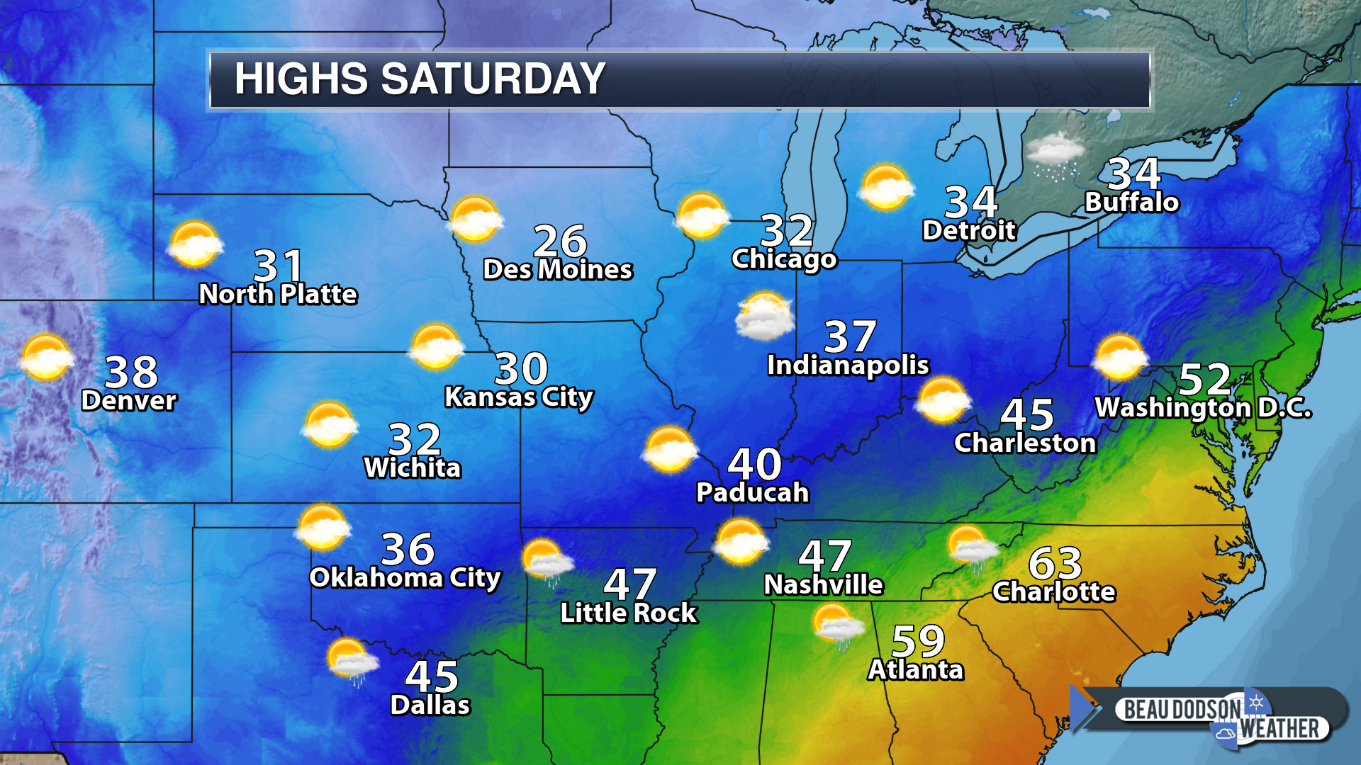
December 29, 2018
Saturday Forecast: Partly cloudy. Colder.
My confidence in the forecast verifying: Medium (60% confidence in the forecast)
Temperature range: MO ~ 36 to 40 IL ~ 35 to 40 KY ~ 38 to 44 TN ~ 40 to 44
Wind direction and speed: North at 5 to 10 mph
Wind chill (feels like) temperature forecast: 25 to 35
What is the chance/probability of precipitation? MO ~ 0% IL ~ 0% KY ~ 0% TN ~ 0%
Coverage of precipitation: None
Is flash flooding anticipated? No
Is accumulating snow or ice anticipated? No
Is non-accumulating snow or ice anticipated? No
Are icy road conditions anticipated? No
Is severe weather expected? No
The NWS officially defines severe weather as 58 mph wind or great, 1″ hail or larger, and/or tornadoes
Will lightning be possible? No
What impacts are anticipated from the weather? Early morning fog could lower visibility.
Should I cancel my outdoor plans? No
Will the weather impact my outdoor plans? Chilly conditions may make it uncomfortable for those outdoors. Typical December cold.
UV Index: 2 Low
Sunrise: 7:09 AM
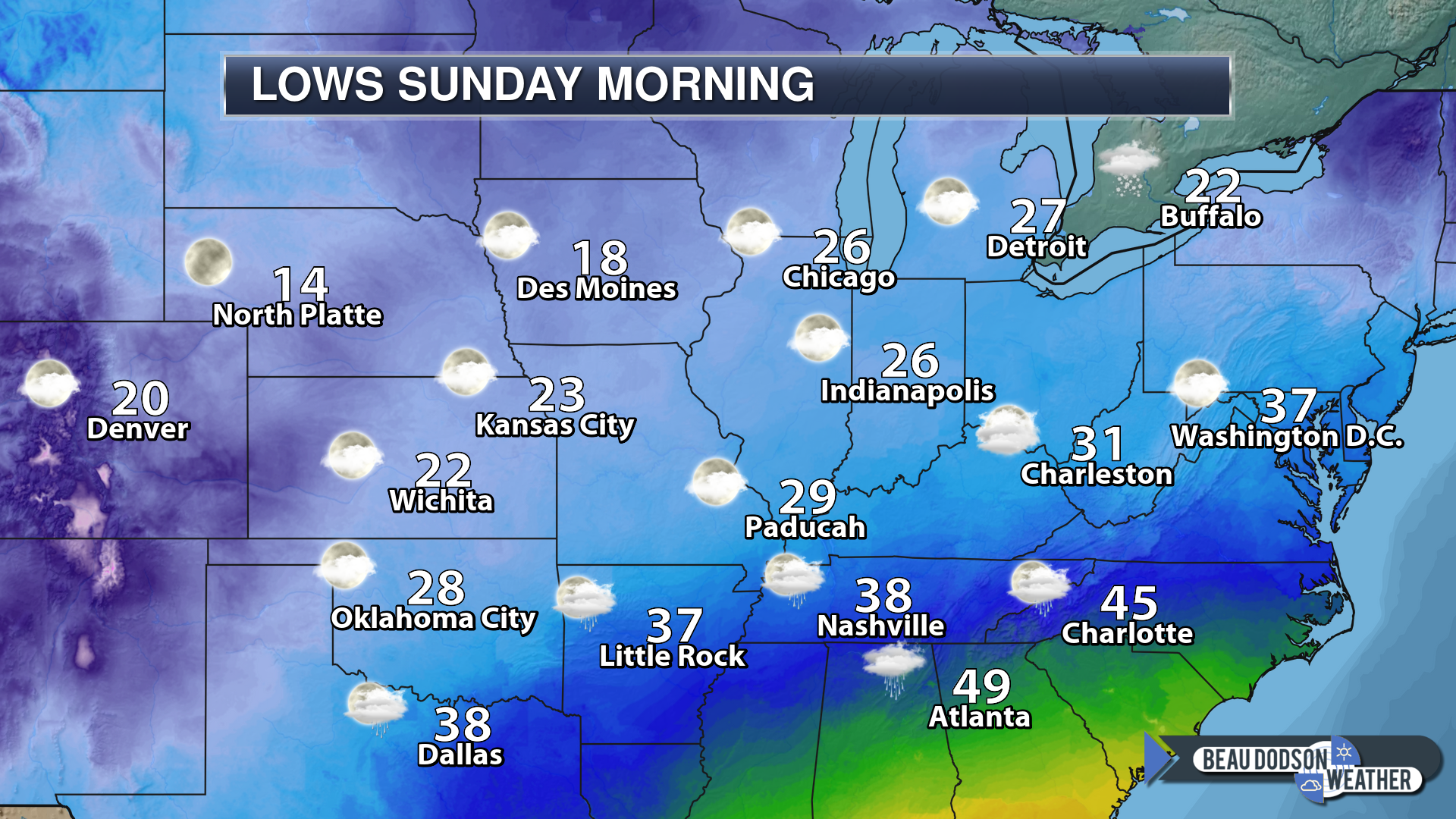
Saturday Night Forecast Details:
Forecast: Partly cloudy. Chilly.
My confidence in the forecast verifying: Medium (50% confidence in the forecast)
Temperature range: MO ~ 26 to 30 IL ~ 28 to 32 KY ~ 28 to 32 TN ~ 30 to 34
Wind direction and speed: Variable at 4 to 8 mph
Wind chill (feels like) temperature forecast: 20 to 30
What is the chance/probability of precipitation? MO ~ 0% IL ~ 0% KY ~ 10% TN ~ 10%
Coverage of precipitation: Most likely none
Is flash flooding anticipated? No
Is accumulating snow or ice anticipated? No
Is non-accumulating snow or ice anticipated? Unlikely
Are icy road conditions anticipated? No
Is severe weather expected? No
The NWS officially defines severe weather as 58 mph wind or great, 1″ hail or larger, and/or tornadoes
Will lightning be possible? No
What impacts are anticipated from the weather? Most likely none
Should I cancel my outdoor plans? No
Will the weather impact my outdoor plans? No
Sunset: 4:45 PM
Moonrise: 11:56 PM Waning Gibbous
Moonset: 12:15 PM
December 30, 2018
Sunday Forecast: Increasing clouds from south to north. Northern areas will remain in sun longer than southern counties. A chance of some late afternoon showers across the Missouri Bootheel and then east along and south of the Kentucky/Tennessee border.
My confidence in the forecast verifying: Medium (40% confidence in the forecast)
Temperature range: MO ~ 42 to 46 IL ~ 40 to 45 KY ~ 43 to 46 TN ~ 45 to 50
Wind direction and speed: East and northeast at 5 to 10 mph with gusts to 12 mph
Wind chill (feels like) temperature forecast:
What is the chance/probability of precipitation? MO ~ 20% IL ~ 20% KY ~ 30% TN ~ 30%
Coverage of precipitation: None during the AM hours. Scattered over our southern counties during the PM hours.
Is flash flooding anticipated? No
Is accumulating snow or ice anticipated? No
Is non-accumulating snow or ice anticipated? No
Are icy road conditions anticipated? No
Is severe weather expected? No
The NWS officially defines severe weather as 58 mph wind or great, 1″ hail or larger, and/or tornadoes
Will lightning be possible? No
What impacts are anticipated from the weather? Wet roads possible during the late PM hours.
Should I cancel my outdoor plans? No
Will the weather impact my outdoor plans? No
UV Index: 2 to 3 Low
Sunrise: 7:09 AM
Sunday Night Forecast Details:
Forecast: Rain increasing south to north. Moderate rain possible late in the night.
My confidence in the forecast verifying: Medium (60% confidence in the forecast)
Temperature range: MO ~ 36 to 42 IL ~ 36 to 42 KY ~ 38 to 42 TN ~ 38 to 44
Wind direction and speed: South and southeast at 5 to 10 mph with gusts to 15 mph
Wind chill (feels like) temperature forecast: 30 to 35
What is the chance/probability of precipitation? MO ~ 30% early and 80% late IL ~ 30% early and 70% late KY ~ 50% early and 90% late TN ~ 60% early and 100% late
Coverage of precipitation: Increasing through the night. Becoming widespread by morning.
Is flash flooding anticipated? Monitor updates. Low-end risk.
Is accumulating snow or ice anticipated? No
Is non-accumulating snow or ice anticipated? No
Are icy road conditions anticipated? No
Is severe weather expected? No
The NWS officially defines severe weather as 58 mph wind or great, 1″ hail or larger, and/or tornadoes
Will lightning be possible? No
What impacts are anticipated from the weather? Wet roadways will be the main concern.
Should I cancel my outdoor plans? Monitor radars and have a plan B in mind
Will the weather impact my outdoor plans? Damp conditions will develop as we push through the night. This will first begin over the Missouri Bootheel and along the Kentucky/Tennessee border. Damp conditions will spread northward. I would monitor radars.
Sunset: 4:46 PM
Moonrise: 12:46 AM Last Quarter
Moonset: 12:47 PM
December 31, 2018
Monday Forecast: Windy. Cloudy. Widespread rain. Thunderstorms are possible. We will need to monitor the severe weather risk. Heavy rain likely. The greatest risk of severe weather will be over western Kentucky and western Tennessee.
My confidence in the forecast verifying: High (70% confidence in the forecast)
Temperature range: MO ~ 46 to 50 IL ~ 46 to 50 KY ~ 54 to 64 TN ~55 to 60
Wind direction and speed: Northeast becoming South at 15 to 30 mph with higher gusts likely. Wind direction and speed will vary across the region. This will depend on the placement of the area of low pressure. Gusty winds are likely.
Wind chill (feels like) temperature forecast:
What is the chance/probability of precipitation? MO ~ 100% IL ~ 100% KY ~ 100% TN ~ 100%
Coverage of precipitation: Widespread
Is flash flooding anticipated? Possible
Is accumulating snow or ice anticipated? No
Is non-accumulating snow or ice anticipated? No
Are icy road conditions anticipated? No
What impacts are anticipated from the weather? Wet roadways are possible. MOnitor the risk of flooding. Monitor the risk of severe weather.
Is severe weather expected? Severe weather may be a concern. This will be highly dependent on where the low-pressure center tracks.
The NWS officially defines severe weather as 58 mph wind or great, 1″ hail or larger, and/or tornadoes
Will lightning be possible? Yes
Should I cancel my outdoor plans? Have a plan B and monitor updates.
Will the weather impact my outdoor plans? Rain will likely interfere with outdoor activities.
UV Index: 1 Low
Sunrise: 7:10 AM
Monday Night Forecast Details:
Forecast: Cloudy. Rain ending.
My confidence in the forecast verifying: Medium (40% confidence in the forecast)
Temperature range: MO ~ 28 to 34 IL ~ 28 to 34 KY ~ 32 to 35 TN ~ 32 to 35
Wind direction and speed: West at 5 to 10 mph with gusts to 30 mph
Wind chill (feels like) temperature forecast: 25 to 35
What is the chance/probability of precipitation? MO ~ 20% early IL ~ 20% early KY ~ 40% before 7 PM TN ~ 40% before 7 PM
Coverage of precipitation: Ending
Is flash flooding anticipated? Streams and rivers may rise. Locally heavy rain on Monday will need to run off.
Is accumulating snow or ice anticipated? No
Is non-accumulating snow or ice anticipated? Most likely no
Are icy road conditions anticipated? No
Is severe weather expected? Monitor updates early in the evening over western Kentucky and western Tennessee
The NWS officially defines severe weather as 58 mph wind or great, 1″ hail or larger, and/or tornadoes
Will lightning be possible? Yes
What impacts are anticipated from the weather? Wet roadways are possible early in the night. Monitor the flooding potential.
Should I cancel my outdoor plans? I would not cancel plans. I would monitor updates and radars. Rain should be ending early in the night if not before.
Will the weather impact my outdoor plans? Damp conditions. Turning colder.
Sunset: 4:47 PM
Moonrise: 1:54 AM Waning Crescent
Moonset: 1:20 PM
January 1, 2018
Tuesday Forecast: Becoming partly cloudy. Colder.
My confidence in the forecast verifying: Medium (40% confidence in the forecast)
Temperature range: MO ~ 36 to 44 IL ~ 36 to 44 KY ~ 40 to 44 TN ~ 40 to 44
Wind direction and speed: Northwest at 6 to 12 mph with gusts to 20 mph
Wind chill (feels like) temperature forecast: 25 to 35
What is the chance/probability of precipitation? MO ~ 0% IL ~ 0% KY ~ 0% TN ~ 0%
Coverage of precipitation: None
Is flash flooding anticipated? No
Is accumulating snow or ice anticipated? No
Is non-accumulating snow or ice anticipated? No
Are icy road conditions anticipated? No
Is severe weather expected? No
The NWS officially defines severe weather as 58 mph wind or great, 1″ hail or larger, and/or tornadoes
Will lightning be possible? No
What impacts are anticipated from the weather? None
Should I cancel my outdoor plans? No
Will the weather impact my outdoor plans? None
UV Index: 2 to 3 Low
Sunrise: 7:10 AM
Tuesday Night Forecast Details:
Forecast: Mostly clear. Cold. Patchy fog.
My confidence in the forecast verifying: Medium (60% confidence in the forecast)
Temperature range: MO ~ 18 to 24 IL ~ 18 to 24 KY ~ 22 to 25 TN ~ 22 to 25
Wind direction and speed: Northwest at 5 to 10 mph
Wind chill (feels like) temperature forecast: 10 to 20
What is the chance/probability of precipitation? MO ~ 0% IL ~ 0% KY ~ 0% TN ~ 0%
Coverage of precipitation: None
Is flash flooding anticipated? No
Is accumulating snow or ice anticipated? No
Is non-accumulating snow or ice anticipated? No
Are icy road conditions anticipated? No
Is severe weather expected? No
The NWS officially defines severe weather as 58 mph wind or great, 1″ hail or larger, and/or tornadoes
Will lightning be possible? No
What impacts are anticipated from the weather? Patchy fog could reduce visibility
Should I cancel my outdoor plans? No
Will the weather impact my outdoor plans? Cold air will make it uncomfortable for those outside. Wind chill values will drop into the 10 to 20 degree range.
Sunset: 4:48 PM
Moonrise: 2:56 AM Waning Crescent
Moonset: 1:53 PM
.
January 2, 2018
Wednesday Forecast: Partly cloudy and chilly.
My confidence in the forecast verifying: Medium (50% confidence in the forecast)
Temperature range: MO ~ 30 to 35 IL ~ 30 to 35 KY ~ 34 to 38 TN ~ 34 to 38
Wind direction and speed: North at 7 to 14 mph
Wind chill (feels like) temperature forecast: 20 to 30
What is the chance/probability of precipitation? MO ~ 0% IL ~ 0% KY ~ 0% TN ~ 0%
Coverage of precipitation: None
Is flash flooding anticipated? No
Is accumulating snow or ice anticipated? No
Is non-accumulating snow or ice anticipated? No
Are icy road conditions anticipated? No
Is severe weather expected? No
The NWS officially defines severe weather as 58 mph wind or great, 1″ hail or larger, and/or tornadoes
Will lightning be possible? No
What impacts are anticipated from the weather? Cold wind chill values
Should I cancel my outdoor plans? No
Will the weather impact my outdoor plans? Cold weather will make it uncomfortable for those outdoors.
UV Index: 2 Low
Sunrise: 7:10 AM
Wednesday Night Forecast Details:
Forecast: Increasing clouds. A chance of a late night wintry mix. Low confidence.
My confidence in the forecast verifying: LOW (30% confidence in the forecast)
Temperature range: MO ~ 20 to 25 IL ~ 20 to 30 KY ~ 22 to 26 TN ~ 23 to 26
Wind chill (feels like) temperature forecast: 15 to 25
What is the chance/probability of precipitation? MO ~ 20% IL ~ 20% KY ~ 20% TN ~ 20%
Coverage of precipitation: Scattered
Is flash flooding anticipated? No
Is accumulating snow or ice anticipated? Monitor
Is non-accumulating snow or ice anticipated? Monitor
Are icy road conditions anticipated? Monitor
Wind direction and speed: North at 6 to 12 mph
Is severe weather expected? No
The NWS officially defines severe weather as 58 mph wind or great, 1″ hail or larger, and/or tornadoes
Will lightning be possible? No
Should I cancel my outdoor plans? Monitor
What impacts are anticipated from the weather? Monitor
Will the weather impact my outdoor plans? Monitor
Sunset: 4:49 PM
Moonrise: 3:56 AM Waning Crescent
Moonset: 2:30 PM
January 3, 2018
Thursday Forecast: Cloudy. A chance of a wintry mix. Low confidence.
My confidence in the forecast verifying: LOW (30% confidence in the forecast)
Temperature range: MO ~ 30 to 35 IL ~ 30 to 35 KY ~ 34 to 38 TN ~ 34 to 38
Wind direction and speed: North at 7 to 14 mph
Wind chill (feels like) temperature forecast: 20 to 30
What is the chance/probability of precipitation? MO ~ 20% IL ~ 20% KY ~ 20% TN ~ 20%
Coverage of precipitation: Scattered
Is flash flooding anticipated? No
Is accumulating snow or ice anticipated? Monitor
Is non-accumulating snow or ice anticipated? Monitor
Are icy road conditions anticipated? Monitor
Is severe weather expected? No
The NWS officially defines severe weather as 58 mph wind or great, 1″ hail or larger, and/or tornadoes
Will lightning be possible? No
What impacts are anticipated from the weather? Monitor
Should I cancel my outdoor plans? Monitor
Will the weather impact my outdoor plans? Monitor
UV Index: 2 Low
Sunrise: 7:10 AM
Thursday Night Forecast Details:
Forecast: Cloudy. A chance of a wintry mix. Low confidence.
My confidence in the forecast verifying: LOW (30% confidence in the forecast)
Temperature range: MO ~ 20 to 25 IL ~ 20 to 30 KY ~ 22 to 26 TN ~ 23 to 26
Wind chill (feels like) temperature forecast: 15 to 25
What is the chance/probability of precipitation? MO ~ 20% IL ~ 20% KY ~ 20% TN ~ 20%
Coverage of precipitation: Scattered
Is flash flooding anticipated? No
Is accumulating snow or ice anticipated? Monitor
Is non-accumulating snow or ice anticipated? Monitor
Are icy road conditions anticipated? Monitor
Wind direction and speed: North at 6 to 12 mph
Is severe weather expected? No
The NWS officially defines severe weather as 58 mph wind or great, 1″ hail or larger, and/or tornadoes
Will lightning be possible? No
Should I cancel my outdoor plans? Monitor
What impacts are anticipated from the weather? Monitor
Will the weather impact my outdoor plans? Monitor
Sunset: 4:49 PM
Moonrise: 4:56 AM Waning Crescent
Moonset: 3:11 PM
January 4, 2018
Friday Forecast: Partly cloudy.
My confidence in the forecast verifying: LOW (30% confidence in the forecast)
Temperature range: MO ~ 35 to 40 IL ~ 35 to 40 KY ~ 35 to 40 TN ~ 35 to 40
Wind direction and speed: North at 5 to 10 mph
Wind chill (feels like) temperature forecast: 30 to 40
What is the chance/probability of precipitation? MO ~ 0% IL ~ 0% KY ~ 0% TN ~ 0%
Coverage of precipitation: None
Is flash flooding anticipated? No
Is accumulating snow or ice anticipated? No
Is non-accumulating snow or ice anticipated? No
Are icy road conditions anticipated? No
Is severe weather expected? No
The NWS officially defines severe weather as 58 mph wind or great, 1″ hail or larger, and/or tornadoes
Will lightning be possible? No
What impacts are anticipated from the weather? None
Should I cancel my outdoor plans? No
Will the weather impact my outdoor plans? None
UV Index: 2 Low
Sunrise: 7:10 AM
Friday Night Forecast Details:
Forecast: Mostly clear. Chilly.
My confidence in the forecast verifying: LOW (30% confidence in the forecast)
Temperature range: MO ~ 25 to 30 IL ~ 25 to 30 KY ~ 25 to 30 TN ~ 25 to 30
Wind chill (feels like) temperature forecast:
What is the chance/probability of precipitation? MO ~ 0% IL ~ 0% KY ~ 0% TN ~ 0%
Coverage of precipitation: None
Is flash flooding anticipated? No
Is accumulating snow or ice anticipated? No
Is non-accumulating snow or ice anticipated? No
Are icy road conditions anticipated? No
Wind direction and speed:
Is severe weather expected? No
The NWS officially defines severe weather as 58 mph wind or great, 1″ hail or larger, and/or tornadoes
Will lightning be possible? No
Should I cancel my outdoor plans? No
What impacts are anticipated from the weather? None
Will the weather impact my outdoor plans? No
Sunset: 4:50 PM
Moonrise: 5:53 AM Waning Crescent
Moonset: 3:55 PM
January 5, 2018
Saturday Forecast: Partly cloudy.
My confidence in the forecast verifying: LOW (30% confidence in the forecast)
Temperature range: MO ~ 38 to 44 IL ~ 38 to 44 KY ~ 38 to 44 TN ~ 38 to 44
Wind direction and speed: North at 5 to 10 mph
Wind chill (feels like) temperature forecast: 30 to 40
What is the chance/probability of precipitation? MO ~ 0% IL ~ 0% KY ~ 0% TN ~ 0%
Coverage of precipitation: None
Is flash flooding anticipated? No
Is accumulating snow or ice anticipated? No
Is non-accumulating snow or ice anticipated? No
Are icy road conditions anticipated? No
Is severe weather expected? No
The NWS officially defines severe weather as 58 mph wind or great, 1″ hail or larger, and/or tornadoes
Will lightning be possible? No
What impacts are anticipated from the weather? None
Should I cancel my outdoor plans? No
Will the weather impact my outdoor plans? None
UV Index: 2 Low
Sunrise: 7:10 AM
Saturday Night Forecast Details:
Forecast: Mostly clear. Chilly.
My confidence in the forecast verifying: LOW (30% confidence in the forecast)
Temperature range: MO ~ 25 to 30 IL ~ 25 to 30 KY ~ 25 to 30 TN ~ 25 to 30
Wind chill (feels like) temperature forecast:
What is the chance/probability of precipitation? MO ~ 0% IL ~ 0% KY ~ 0% TN ~ 0%
Coverage of precipitation: None
Is flash flooding anticipated? No
Is accumulating snow or ice anticipated? No
Is non-accumulating snow or ice anticipated? No
Are icy road conditions anticipated? No
Wind direction and speed:
Is severe weather expected? No
The NWS officially defines severe weather as 58 mph wind or great, 1″ hail or larger, and/or tornadoes
Will lightning be possible? No
Should I cancel my outdoor plans? No
What impacts are anticipated from the weather? None
Will the weather impact my outdoor plans? No
Sunset: 4:51 PM
Moonrise: 6:45 AM Waning Crescent
Moonset: 4:43 PM
January 6, 2018
Sunday Forecast: Partly cloudy.
My confidence in the forecast verifying: LOW (30% confidence in the forecast)
Temperature range: MO ~ 38 to 44 IL ~ 38 to 44 KY ~ 38 to 44 TN ~ 38 to 44
Wind direction and speed: North at 5 to 10 mph
Wind chill (feels like) temperature forecast: 30 to 40
What is the chance/probability of precipitation? MO ~ 0% IL ~ 0% KY ~ 0% TN ~ 0%
Coverage of precipitation: None
Is flash flooding anticipated? No
Is accumulating snow or ice anticipated? No
Is non-accumulating snow or ice anticipated? No
Are icy road conditions anticipated? No
Is severe weather expected? No
The NWS officially defines severe weather as 58 mph wind or great, 1″ hail or larger, and/or tornadoes
Will lightning be possible? No
What impacts are anticipated from the weather? None
Should I cancel my outdoor plans? No
Will the weather impact my outdoor plans? None
UV Index: 2 Low
Sunrise: 7:10 AM
Sunday Night Forecast Details:
Forecast: Mostly clear. Chilly.
My confidence in the forecast verifying: LOW (30% confidence in the forecast)
Temperature range: MO ~ 25 to 30 IL ~ 25 to 30 KY ~ 25 to 30 TN ~ 25 to 30
Wind chill (feels like) temperature forecast:
What is the chance/probability of precipitation? MO ~ 0% IL ~ 0% KY ~ 0% TN ~ 0%
Coverage of precipitation: None
Is flash flooding anticipated? No
Is accumulating snow or ice anticipated? No
Is non-accumulating snow or ice anticipated? No
Are icy road conditions anticipated? No
Wind direction and speed:
Is severe weather expected? No
The NWS officially defines severe weather as 58 mph wind or great, 1″ hail or larger, and/or tornadoes
Will lightning be possible? No
Should I cancel my outdoor plans? No
What impacts are anticipated from the weather? None
Will the weather impact my outdoor plans? No
Sunset: 4:52 PM
Moonrise: 7:35 AM New
Moonset: 5:33 PM
Learn more about the UV index readings. Click here.
Wind forecast
See wind forecast above in the daily details
.

Friday: Wintry precipitation is not anticipated.
Saturday: Wintry precipitation is not anticipated.
Sunday: Wintry precipitation is not anticipated.
Monday and Monday night: Wintry precipitation is not anticipated.
Tuesday: Wintry precipitation is not anticipated.
Wednesday: Wintry precipitation is not anticipated.
Wednesday night and Thursday: Wintry precipitation is not anticipated.

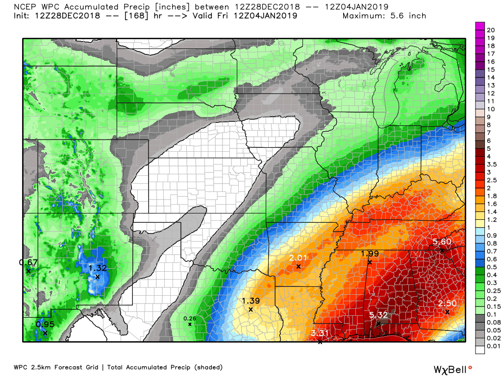
Here is the WPC/NOAA rainfall outlook.
Click to enlarge graphics on the blog.
Heavy rain is possible Sunday night and especially Monday
Subscribers, do you need a forecast for an outdoor event?

Did you know that you can find me on Twitter?


We offer interactive local city live radars and regional radars.
If a radar does not update then try another one. If a radar does not appear to be refreshing then hit Ctrl F5 on your keyboard.
You may also try restarting your browser. The local city view radars also have clickable warnings.
During the winter months, you can track snow and ice by clicking the winterize button on the local city view interactive radars.

Questions? Broken links? Other questions?
You may email me at beaudodson@usawx.com

The National Weather Service defines a severe thunderstorm as one that produces quarter size hail or larger, 58 mph winds or greater, and/or a tornado.
Friday through Wednesday: Severe thunderstorms are possible Monday. The track of the area of low pressure is key to where severe storms may occur. The main concern will be a line of thunderstorms. Occasionally, these type of systems can produce short-lived tornadoes.
Let’s keep an eye on Monday. Greatest concern may end up being across western Kentucky and western Tennessee.
Interactive live weather radar page. Choose the city nearest your location. If one of the cities does not work then try a nearby one. Click here.
National map of weather watches and warnings. Click here.
Storm Prediction Center. Click here.
Weather Prediction Center. Click here.

Live lightning data: Click here.

Interactive GOES R satellite. Track clouds. Click here.

Here are the latest local river stage forecast numbers Click Here.
Here are the latest lake stage forecast numbers for Kentucky Lake and Lake Barkley Click Here.

- Our rain has ended. Windy conditions are subsiding, as well
- Dry today through Sunday morning
- Widespread rain event likely Sunday night into Monday
- Some heavy rain possible Monday
- Monitoring the risk of severe weather Monday
- Dry Tuesday into Thursday
FORECAST
Today:
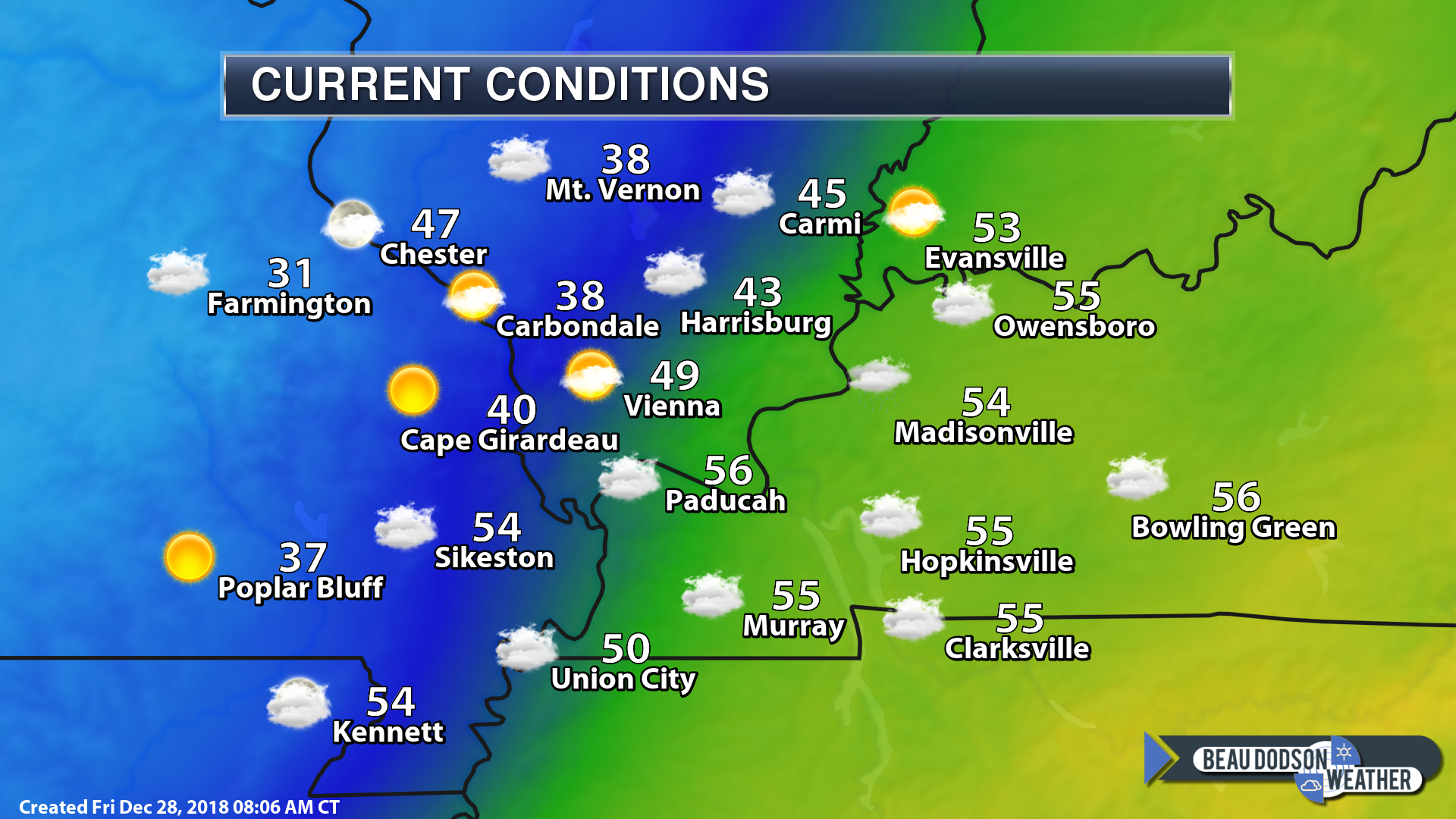
A dry day on tap for the region. The area is split in two by the eastward moving cold front.
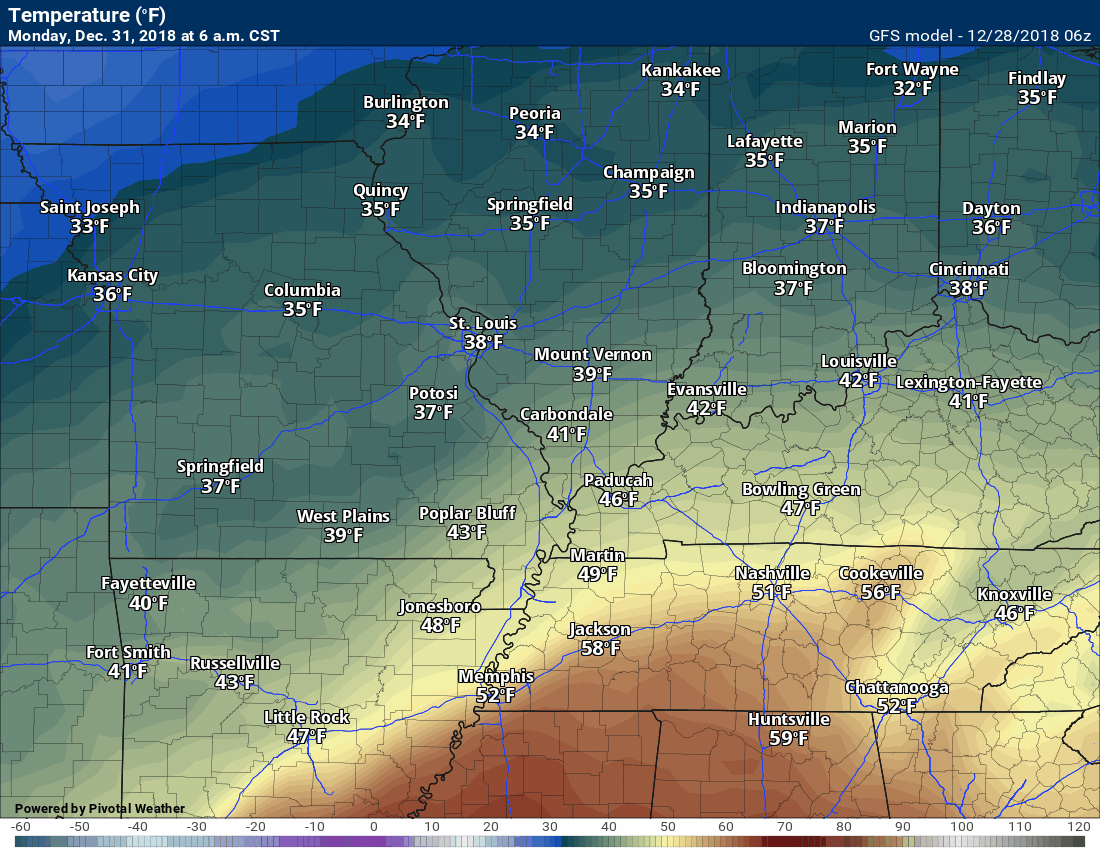
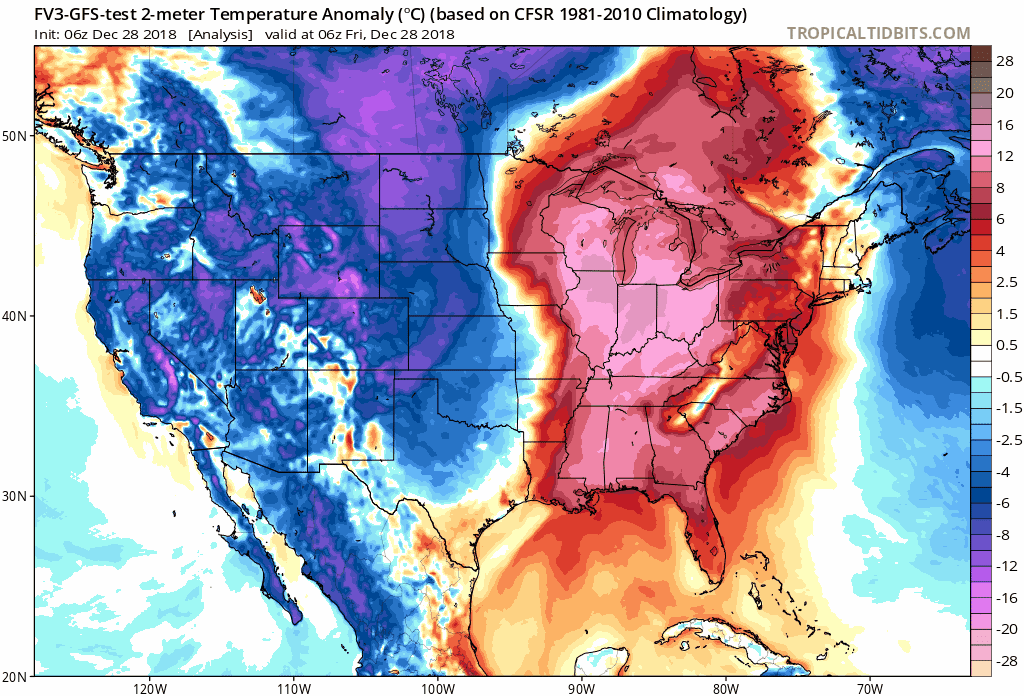
Check out the 8 AM temperatures. Brrr over our western counties. Milder over our eastern counties.
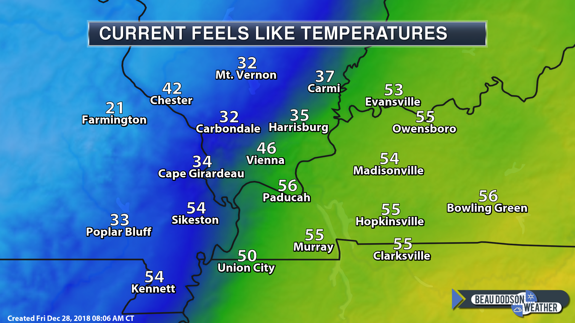
Feels like temperatures
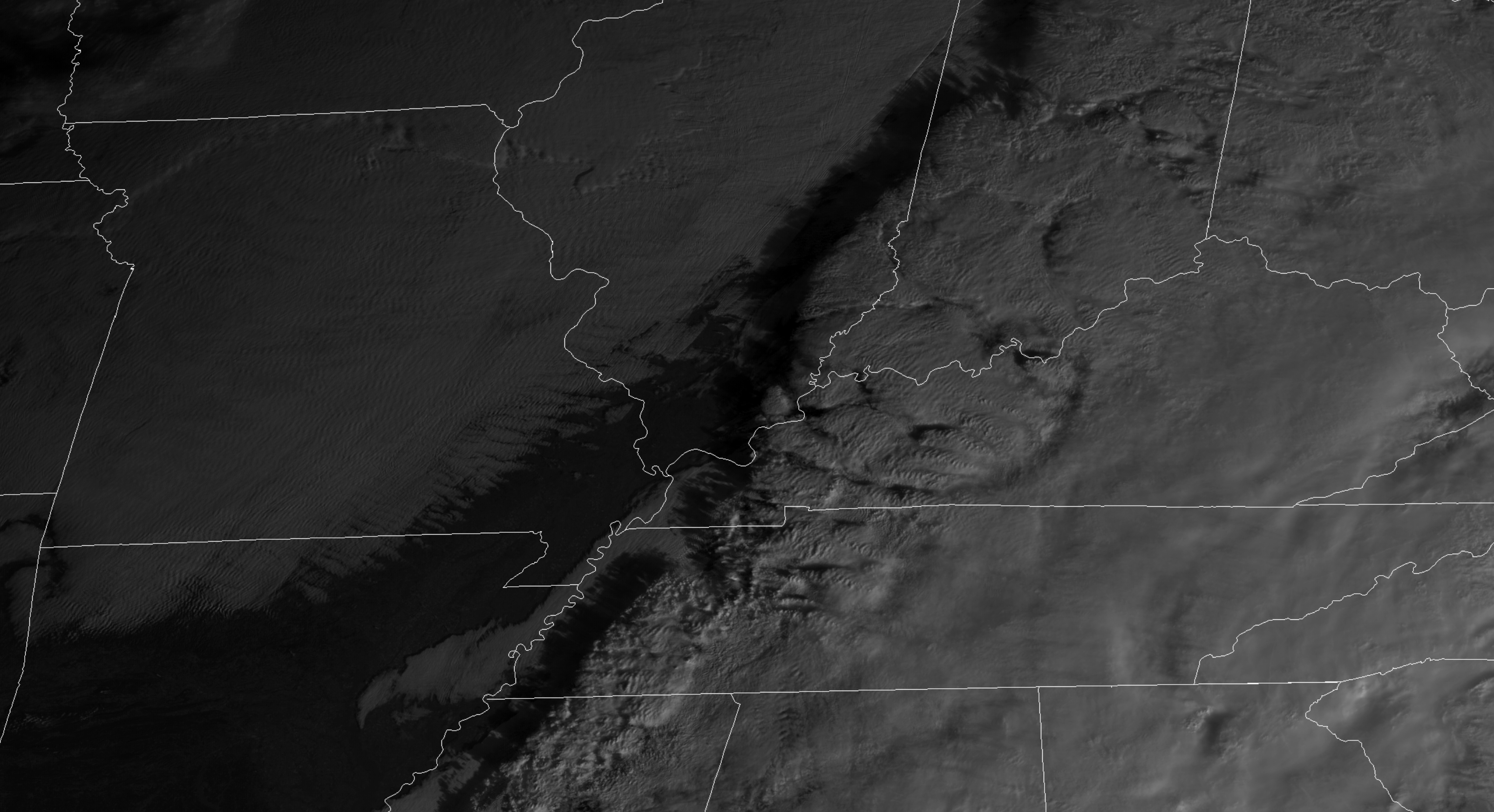
We still have clouds in the region. The early morning visible satellite shows clouds over the eastern half of the region. There is a band of clearing across portions of the region, as well.
You can then see low clouds to our west moving eastward.
This all means intervals of clouds today.
You can see the morning satellite view.
Live satellite views. Click here
Warm air continues to spread northward into our region. These warm temperatures are coming out of the Gulf of Mexico and the southern United States.
This is because the cold front is still well to our west. The deep area of low pressure is to our west. Low pressure rotates counter-clockwise. That is helping to drive the warm and moist air northward.
Here is the temperature forecast map for today.
Tonight through Sunday morning:
Dry conditions. A few clouds from time to time. It will be on the cool side. See the daily details at the top of the page.
Sunday night into Monday afternoon
An active weather pattern returns to the region by late Sunday afternoon into Monday afternoon.
A widespread rain event will develop from north to south. I can’t rule out some thunderstorms by Monday late morning into the afternoon hours.
The risk of thunderstorms will be dependent on the track of the area of low pressure.
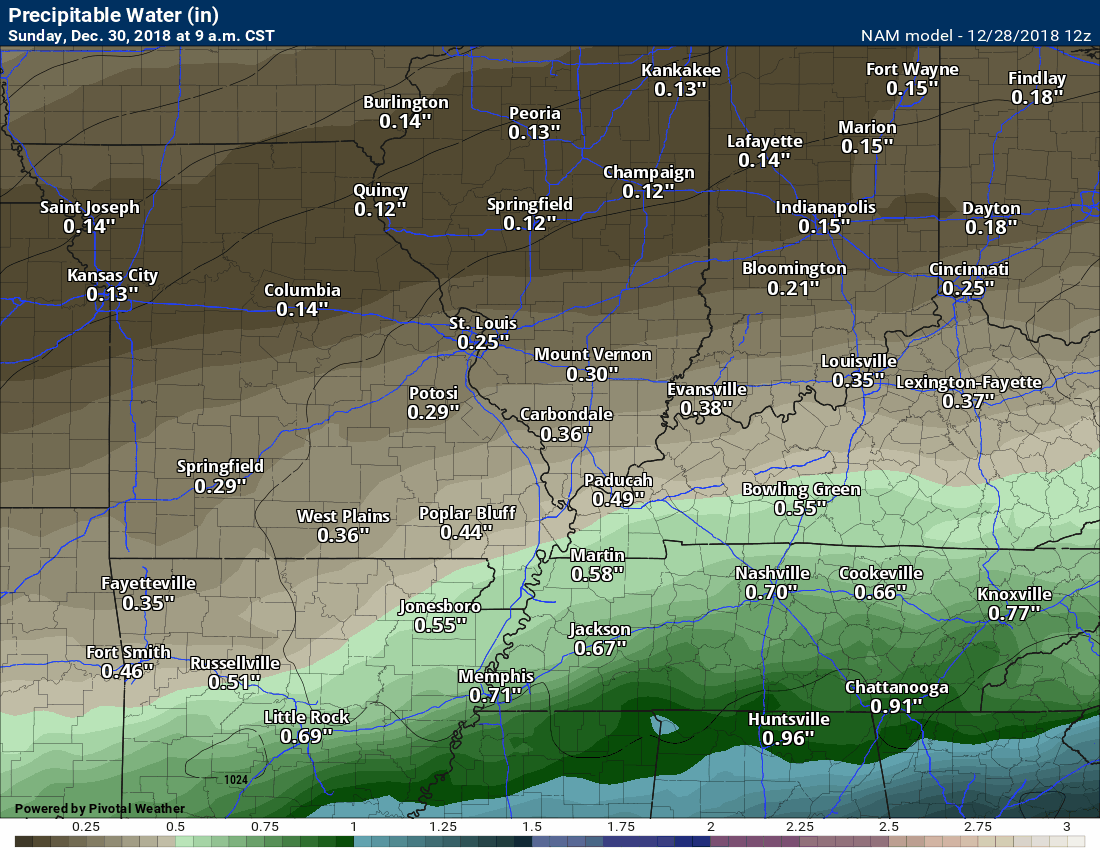
The warm sector is always on the eastern and southeastern side of the low. Currently, the low is forecast to track across western Tennessee and western Kentucky.
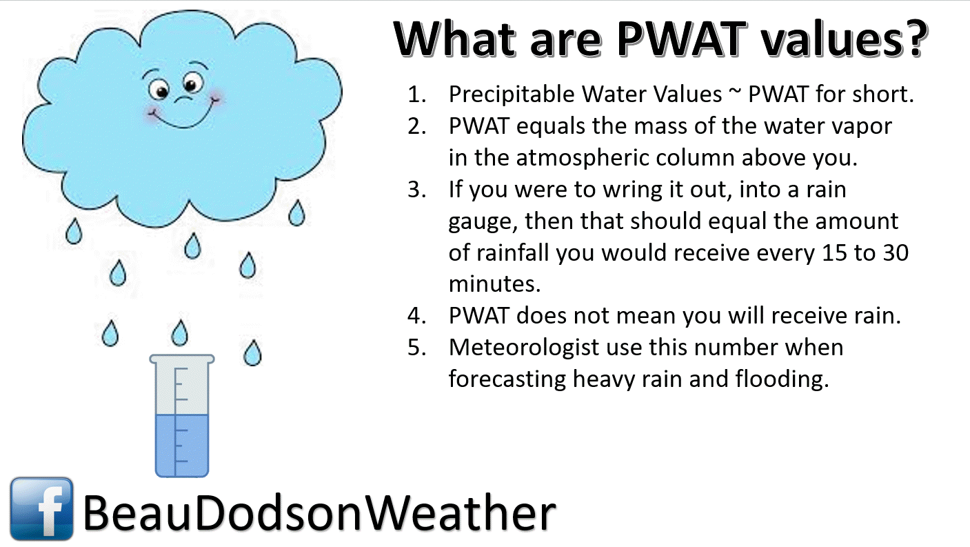
Let’s look at the precipitable water values for this event. These are high numbers for the winter months.
What does that mean? It means heavy rain will likely occur with the Monday event.
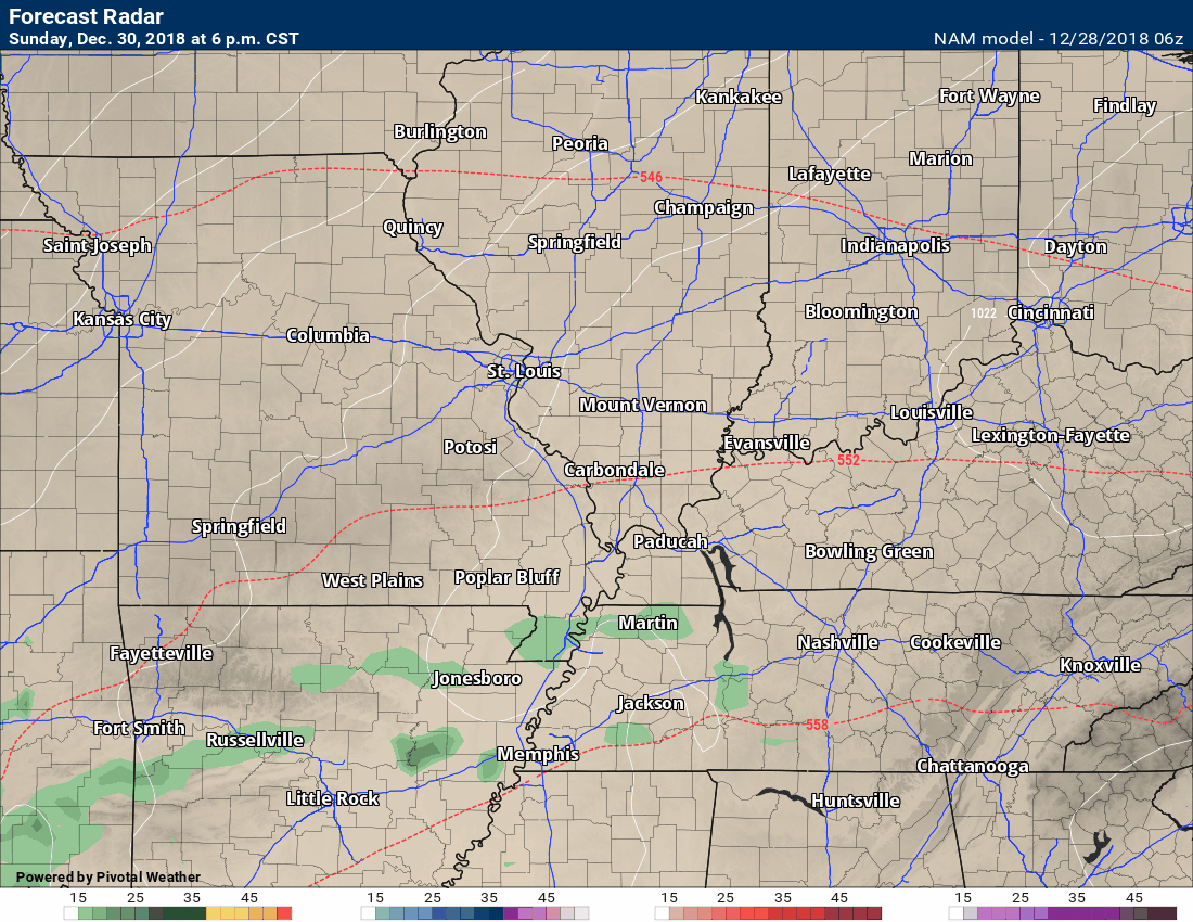
Here is the animation. You can see the surge pushing northward Monday.
Here is the NAM future-cast radar.
The NAM does not bring as much rain in by Sunday night vs other models. I am monitoring this.
I do have rain increasing south to north late Sunday afternoon into Sunday night.
The NAM attempts to bring most of the rain in after midnight Sunday into Monday early afternoon.
Compare the above to the GFS model guidance below.
The GFS brings a surge of rain into the region as early as Sunday evening and then into the overnight hours.
The differences are mainly concerning the timing of the rain.

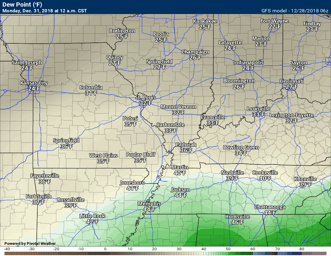
Here is the dew point animation. Time-stamp upper left.
A surge of higher dew points will push northward Monday.
I usually watch for 58 degrees and above (dew points) when considering severe weather. We may reach those numbers across portions of Kentucky and Tennessee.
Again, let’s keep an eye on it.
Let’s check out the temperature forecast for behind the Monday cold front.
An impressive surge of warmer air ahead of the cold front. Portions of the region, at least.
A surge of cold air follows. We may dip into the teens next week for overnight lows.
Time-stamp upper left
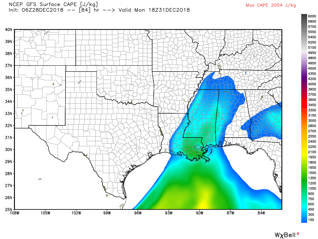
Here is the GFS CAPE forecast. Remember, CAPE is energy for thunderstorms. The GFS does not bring CAPE into our region.
This is what we will need to monitor.
CAPE would mean a risk of severe thunderstorms.
The primary concern would be Kentucky and Tennessee.
These CAPE numbers could shift northward with time. I will monitor trends.
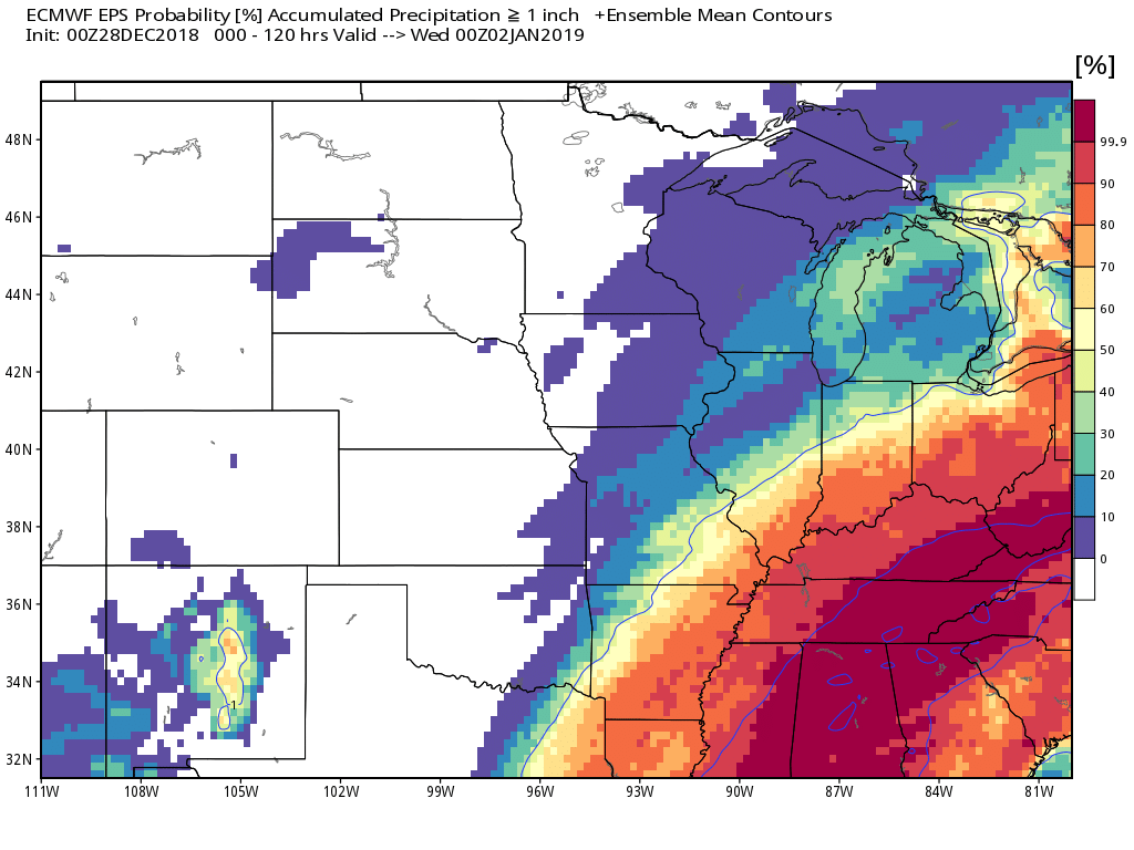
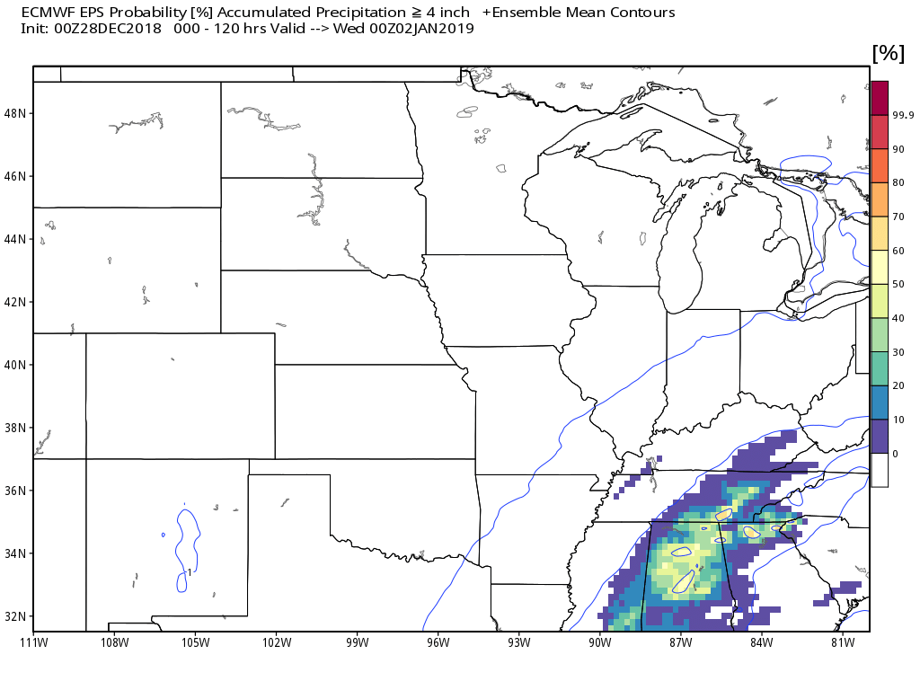
What is the probability of 1″ or more of rain falling?
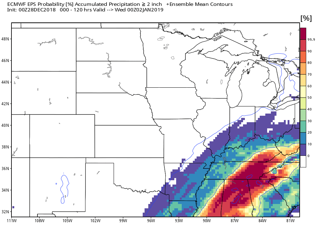
What is the probability of 2″ or more of rain falling?
What is the probability of 4″ or more of rain falling?
Dry weather is likely Monday night into Thursday.
We will need to monitor the risk of fog during the overnight hours. Freezing fog is a possibility, as well.
No snowstorms in the charts, at this time.
Temperature Anomalies
Let’s look at the temperature anomaly forecast map from the GFS model guidance.
I will keep showing you this graphic animation over the coming weeks.
Red colors indicate above normal temperatures. Blue colors represent below normal temperatures.
The time-stamp is located in the upper left portion of the map animation.
The models have been swinging back and forth on the subject of warm vs cold.
Click to enlarge. Date stamp upper left.
![]()

I bring these to you from the BAMwx team. They are excellent long-range forecasters.
Remember, long-range outlooks are a bit of skill, understanding weather patterns, and luck combined. It is not an exact science.

This product is for subscribers.
Subscribe at www.weathertalk.com
Subscriber graphics can be viewed on this page CLICK HERE

This product is for subscribers.

This product is for subscribers.
Subscribe at www.weathertalk.com
Subscriber graphics can be viewed on this page CLICK HERE
![]()
.
Winter Outlook!
These products are for subscribers.
December temperature and precipitation outlook
January temperature outlook
February temperature outlook
Winter snow outlook
.These products are for subscribers.
![]()

A new weather podcast is now available! Weather Geeks (which you might remember is on The Weather Channel each Sunday)
To learn more visit their website. Click here.
![]()

WeatherBrains Episode 675
Tonight’s Guest WeatherBrain is the Warning Coordination Meteorologist at the Storm Prediction Center. Since 1996, he has performed as a severe weather, fire weather, mesoscale, and lead forecaster at the SPC. Greg Carbin, welcome to the show!
Also joining us as Guest Panelist is the Lead Forecaster at the Storm Prediction Center, Rich Thompson. Welcome to WeatherBrains!
Other discussions in this weekly podcast include topics like:
- What really happens during a government shutdown?
- More hurricane-related fatalities in 2018 than tornado-related fatalities
- 2018 Hurricane Michael’s aftermath largely ignored by national media?
- Probability of seeing a Day 3 Convective Outlook “High Risk”
- and more!
Link to their website https://weatherbrains.com/
Previous episodes can be viewed by clicking here.

We offer interactive local city live radars and regional radars. If a radar does not update then try another one. If a radar does not appear to be refreshing then hit Ctrl F5. You may also try restarting your browser.
The local city view radars also have clickable warnings.
During the winter months, you can track snow and ice by clicking the winterize button on the local city view interactive radars.
You may email me at beaudodson@usawx.com
Find me on Facebook!

Find me on Twitter!

Did you know that a portion of your monthly subscription helps support local charity projects?
You can learn more about those projects by visiting the Shadow Angel Foundation website and the Beau Dodson News website.

I encourage subscribers to use the app vs regular text messaging. We have found text messaging to be delayed during severe weather. The app typically will receive the messages instantly. I recommend people have three to four methods of receiving their severe weather information.
Remember, my app and text alerts are hand typed and not computer generated. You are being given personal attention during significant weather events.
