
Your daily forecast into the coming weekend.
December 28, 2017
Thursday Night Forecast Details:
Forecast: Partly cloudy and cold.
Temperatures: MO ~ 15 to 20 IL ~ 14 to 18 KY ~ 15 to 20
What is the chance of precipitation? MO ~ 10% IL ~ 10% KY ~ 10%
Coverage of precipitation: Most likely none
Wind chill values: 10 to 15
Accumulating snow or ice: No
Winds: West winds at 0 to 5 mph
What impacts are anticipated from the weather? Low wind chills.
My confidence in the forecast verifying: High
Is severe weather expected? No
The NWS defines severe weather as 58 mph wind or great, 1″ hail or larger, and/or tornadoes
Should I cancel my outdoor plans: No, but it will be cold
.
December 29, 2017
Friday Forecast Details
Forecast: Partly sunny morning. Afternoon clouds. A few snow flurries or snow showers possible (esp northern portions of southern Illinois into northwest Kentucky). No accumulation to a dusting. Odds favor no accumulation.
Temperatures: MO ~ 30 to 35 IL ~ 30 to 35 KY ~ 32 to 36
What is the chance of precipitation? MO ~ 10% IL ~ 20% KY ~ 20%
Coverage of precipitation: Scattered over our north and northeast counties
Wind chill values: 15 to 25
Accumulating snow or ice: Unlikely. Small chance of a dusting.
Winds: North and northwest at 5 to 10 mph with gusts to 15 mph
What impacts are anticipated from the weather? Cold wind chills. I will monitor the snow chances. Dusting possible for some.
My confidence in the forecast verifying: Medium
Is severe weather expected? No
The NWS defines severe weather as 58 mph wind or great, 1″ hail or larger, and/or tornadoes
Should I cancel my outdoor plans? No, but it will be cold
.
Friday Night Forecast Details:
Forecast: Cloudy and cold. A slight chance of snow showers or flurries.
Temperatures: MO ~ 22 to 26 IL ~ 22 to 26 KY ~ 22 to 26
What is the chance of precipitation? MO ~ 20% IL ~ 20% KY ~ 20%
Coverage of precipitation: Isolated
Wind chill values: 5 to 15 degrees
Accumulating snow or ice: Unlikely
Winds: South and southwest at 5 to 10 mph
What impacts are anticipated from the weather? Cold wind chills.
My confidence in the forecast verifying: High
Is severe weather expected? No
The NWS defines severe weather as 58 mph wind or great, 1″ hail or larger, and/or tornadoes
Should I cancel my outdoor plans: No, but it will be cold
.
December 30, 2017
Saturday Forecast Details
Forecast: Partly sunny. A flurry possible. Cold.
Temperatures: MO ~ 24 to 28 IL ~ 24 to 28 KY ~ 26 to 32
What is the chance of precipitation? MO ~ 20% IL ~ 20% KY ~ 20%
Coverage of precipitation: Isolated
Wind chill values: 5 to 15 above
Accumulating snow or ice: Unlikely
Winds: North and northeast at 6 to 12 mph with gusts to 20
What impacts are anticipated from the weather? Low wind chills
My confidence in the forecast verifying: High
Is severe weather expected? No
The NWS defines severe weather as 58 mph wind or great, 1″ hail or larger, and/or tornadoes
Should I cancel my outdoor plans? No, but it will be cold
.
Saturday Night Forecast Details:
Forecast: Clearing. A few clouds. Bitterly cold air.
Temperatures: MO ~ +4 to 8 IL ~ +4 to 8 KY ~ +6 to 12
What is the chance of precipitation? MO ~ 5% IL ~ 5% KY ~ 5%
Coverage of precipitation: Most likely none
Wind chill values: -10 to 10 above
Accumulating snow or ice: No
Winds: North and northeast at 5 to 10 mph with gusts to 15 mph
What impacts are anticipated from the weather? Bitterly cold wind chills.
My confidence in the forecast verifying: High
Is severe weather expected? No
The NWS defines severe weather as 58 mph wind or great, 1″ hail or larger, and/or tornadoes
Should I cancel my outdoor plans: No, but it will be cold
.
December 31, 2017
Sunday Forecast Details
Forecast: Mostly sunny. Some passing clouds. Bitterly cold.
Temperatures: MO ~ 15 to 20 IL ~ 15 to 20 KY ~ 16 to 22
What is the chance of precipitation? MO ~ 5% IL ~ 5% KY ~ 5%
Coverage of precipitation: Most likely none
Wind chill values: -10 to 15 above
Accumulating snow or ice: No
Winds: North and northeast at 6 to 12 mph with gusts to 20 mph
What impacts are anticipated from the weather? Cold wind chills
My confidence in the forecast verifying: High
Is severe weather expected? No
The NWS defines severe weather as 58 mph wind or great, 1″ hail or larger, and/or tornadoes
Should I cancel my outdoor plans? No, but it will be cold
.
Sunday Night Forecast Details:
Forecast: Most clear. Bitterly cold.
Temperatures: MO ~ +3 to 8 IL ~ +2 to 10 KY ~ +3 to 6
What is the chance of precipitation? MO ~ 0% IL ~ 0% KY ~ 0%
Coverage of precipitation: None
Wind chill values: -15 to 10 degrees above
Accumulating snow or ice: No
Winds: North at 8 to 16 mph
What impacts are anticipated from the weather? Bitterly cold
My confidence in the forecast verifying: High
Is severe weather expected? No
The NWS defines severe weather as 58 mph wind or great, 1″ hail or larger, and/or tornadoes
Should I cancel my outdoor plans: No, but it will be cold
.
January 1, 2018
Monday Forecast Details
Forecast: Partly to mostly sunny. Bitterly cold.
Temperatures: MO ~ 14 to 18 IL ~ 14 to 18 KY ~ 15 to 20
What is the chance of precipitation? MO ~ 0% IL ~ 0% KY ~ 0%
Coverage of precipitation: None
Wind chill values: -12 to 5 above
Accumulating snow or ice: No
Winds: North and northeast at 6 to 12 mph
What impacts are anticipated from the weather? Cold wind chills.
My confidence in the forecast verifying: High
Is severe weather expected? No
The NWS defines severe weather as 58 mph wind or great, 1″ hail or larger, and/or tornadoes
Should I cancel my outdoor plans? No, but it will be cold
.
Monday Night Forecast Details:
Forecast: Mostly clear and bitterly cold.
Temperatures: MO ~ -1 to +6 IL ~ -1 to +6 KY ~ 2 to 6
What is the chance of precipitation? MO ~ 0% IL ~ 0% KY ~ 0%
Coverage of precipitation: Most likely none
Wind chill values: -15 to 5 degrees above
Accumulating snow or ice: No
Winds: North winds at 5 to 10 mph
What impacts are anticipated from the weather? Cold wind chills
My confidence in the forecast verifying: High
Is severe weather expected? No
The NWS defines severe weather as 58 mph wind or great, 1″ hail or larger, and/or tornadoes
Should I cancel my outdoor plans: No, but it will be cold
.
January 2, 2018
Tuesday Forecast Details
Forecast: Sunny. Cold.
Temperatures: MO ~ 18 to 24 IL ~ 18 to 24 KY ~ 20 to 25
What is the chance of precipitation? MO ~ 0% IL ~ 0% KY ~ 0%
Coverage of precipitation: None
Wind chill values: +5 to 15 above
Accumulating snow or ice: No
Winds: North and northeast at 6 to 12 mph. Winds becoming variable.
What impacts are anticipated from the weather? Cold wind chills.
My confidence in the forecast verifying: High
Is severe weather expected? No
The NWS defines severe weather as 58 mph wind or great, 1″ hail or larger, and/or tornadoes
Should I cancel my outdoor plans? No, but it will be cold
.
Tuesday Night Forecast Details:
Forecast: Mostly clear and bitterly cold.
Temperatures: MO temp range 7 to 14 IL temp range 6 to 12 KY temp range 7 to 14
What is the chance of precipitation? MO ~ 0% IL ~ 0% KY ~ 0%
Coverage of precipitation: None
Wind chill values: -15 to 5 degrees above
Accumulating snow or ice: No
Winds: North winds at 4 to 8 mph
What impacts are anticipated from the weather? Cold wind chills
My confidence in the forecast verifying: High
Is severe weather expected? No
The NWS defines severe weather as 58 mph wind or great, 1″ hail or larger, and/or tornadoes
Should I cancel my outdoor plans: No, but it will be cold
.
January 3, 2018
Wednesday Forecast Details
Forecast: Partly sunny. Cold.
Temperatures: MO ~ 25 to 30 IL ~ 25 to 30 KY ~ 25 to 30
What is the chance of precipitation? MO ~ 0% IL ~ 0% KY ~ 0%
Coverage of precipitation: None
Wind chill values: 10 to 20
Accumulating snow or ice: No
Winds:
What impacts are anticipated from the weather?
My confidence in the forecast verifying: High
Is severe weather expected? No
The NWS defines severe weather as 58 mph wind or great, 1″ hail or larger, and/or tornadoes
Should I cancel my outdoor plans? No, but it will be cold
.
Wednesday Night Forecast Details:
Forecast: Mostly clear and bitterly cold.
Temperatures: MO temp range 7 to 14 IL temp range 6 to 12 KY temp range 7 to 14
What is the chance of precipitation? MO ~ 0% IL ~ 0% KY ~ 0%
Coverage of precipitation: None
Wind chill values: -10 to 5 degrees above
Accumulating snow or ice: No
Winds:
What impacts are anticipated from the weather? Cold wind chills
My confidence in the forecast verifying: High
Is severe weather expected? No
The NWS defines severe weather as 58 mph wind or great, 1″ hail or larger, and/or tornadoes
Should I cancel my outdoor plans: No, but it will be cold
.

.
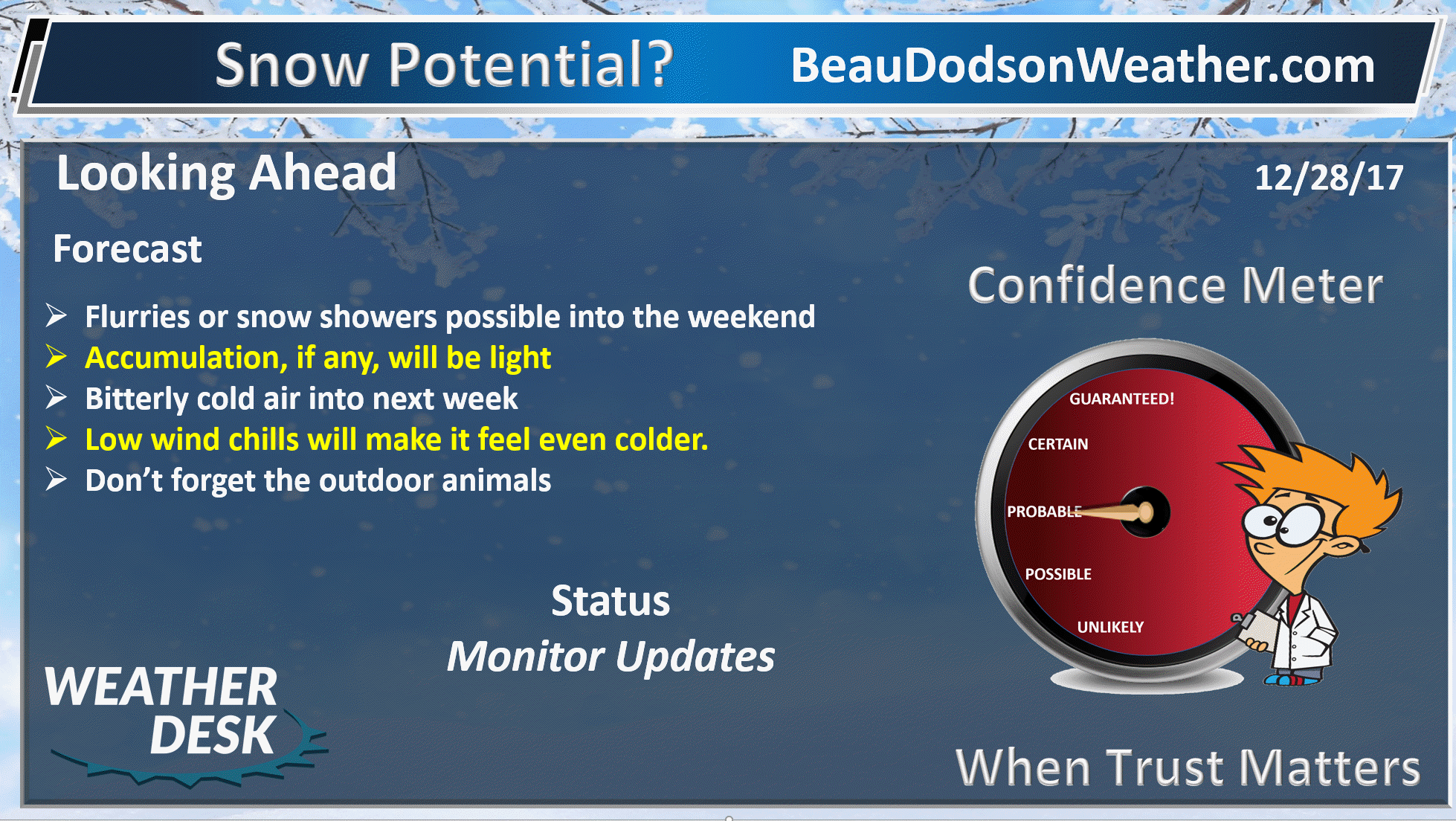
Thursday night through next Tuesday: Periodic snow flurry or snow shower chances. Bitterly cold air. Widespread accumulating snow is unlikely.
Widespread accumulating snow is unlikely.
.

.
The National Weather Service definition of a severe thunderstorm is one that produces quarter size hail or larger, 58 mph winds or greater, and/or a tornado.
Now through next Saturday: Severe storms are not anticipated.
.

Forecast
More cold weather in the forecast. Not much snow. Dry weather to continue into next week.
We will have an occasional snow shower or flurry, but nothing to write home about.
The big story will be the cold air.
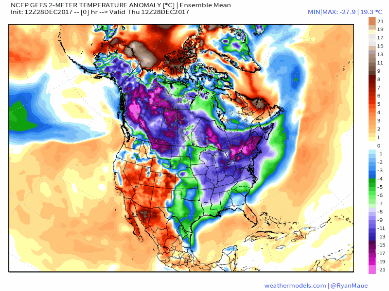
Here is the temperature anomaly animation map through January 13th. Cold and more cold. Scale is on the right side of the image. This is how many degrees above or below normal temperatures will be.
.
.
Monitor updated forecasts over the coming days.
Interactive Weather Radar Page. Choose the city nearest your location: Click this link
Reminders
.
Thursday into Friday
Cold weather is going to continue into next week. Bitterly cold air, at times. Wind chills will occasionally dip below zero.
Friday high temperatures will mostly be in the 30’s. I guess that beats the 20’s. Not by much!
Highs on Saturday will remain mostly in the middle to upper 20’s. It will be even colder on Sunday with high temperatures in the teens. Same for Monday.
These temperatures are unusual without snow on the ground. Yet, that is the forecast and confidence is high.
You can expect single digit lows Saturday night through Monday night.
Normal high temperatures are around 43 degrees. Normal low temperatures are around 25 degrees.
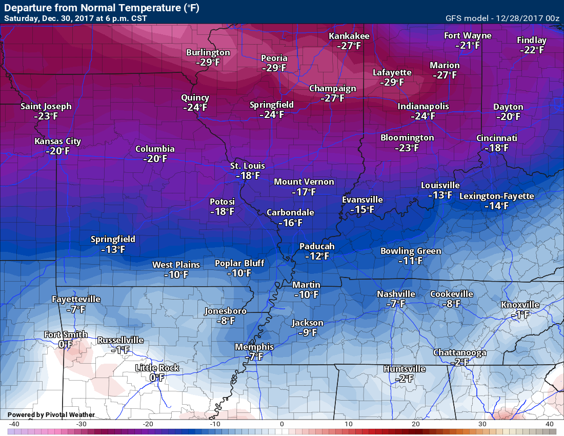
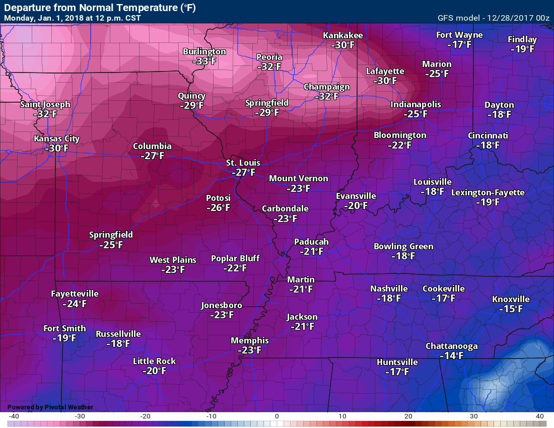
Look at these temperature anomaly maps. These maps show you how many degrees below normal temperatures will be.
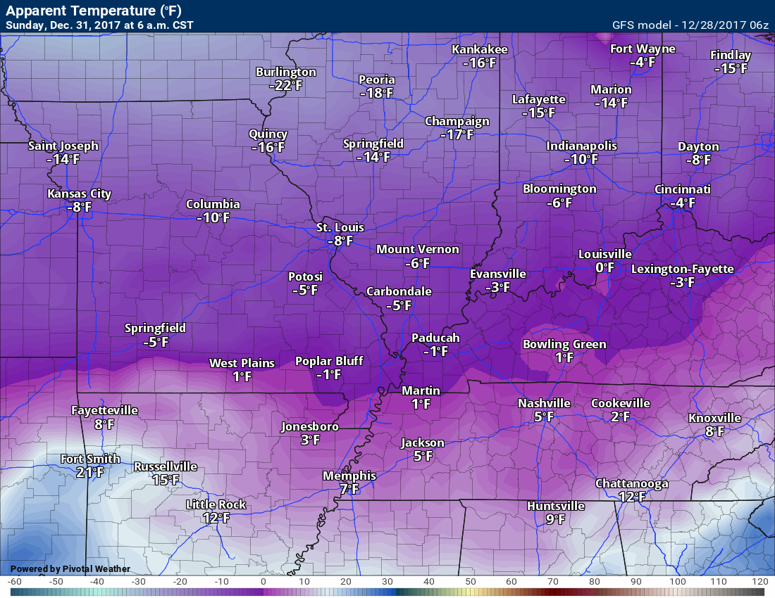
This map is 12 AM on Monday (Sunday night)
WELL below normal temperatures.
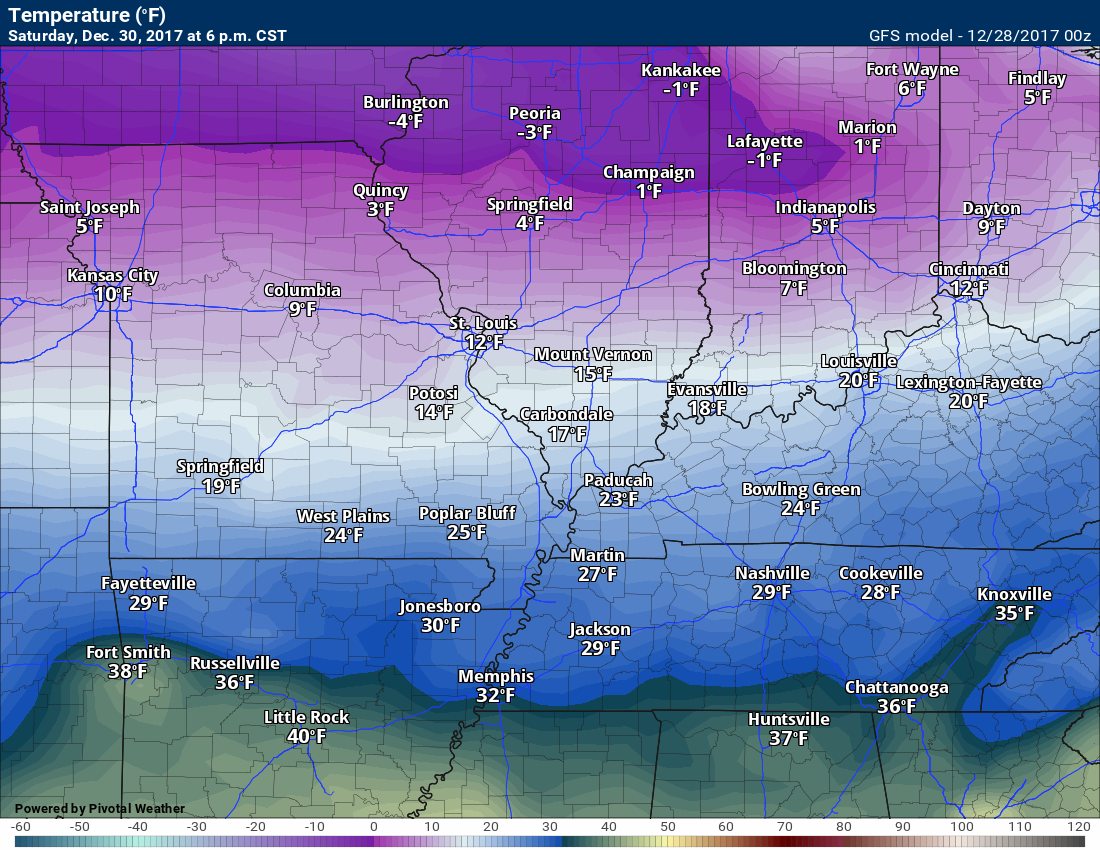
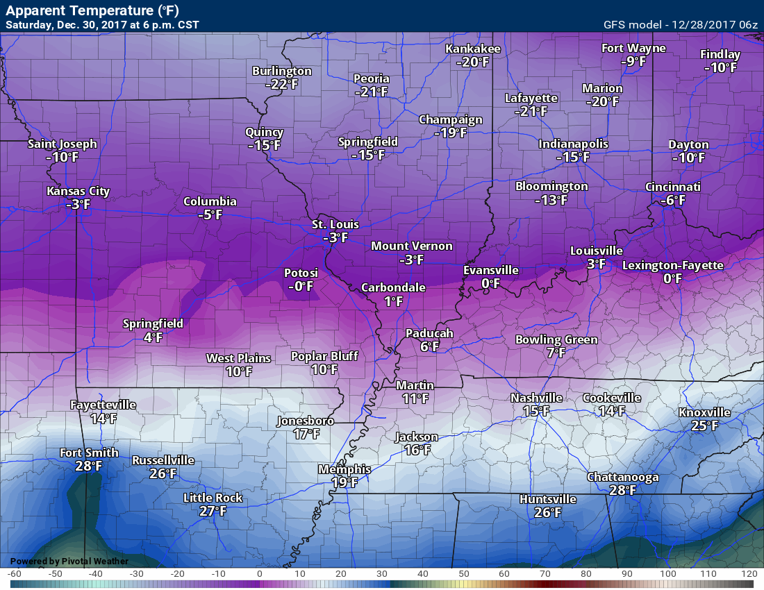
Saturday 6 PM temperature anomalies
How many degrees below normal will temperatures be?
.
And here is the 6 PM air temperature map
.
.
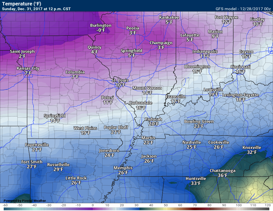
Sunday 12 PM temperature anomalies
.

,
And here is the Sunday 12 PM air temperature map
.
.
.
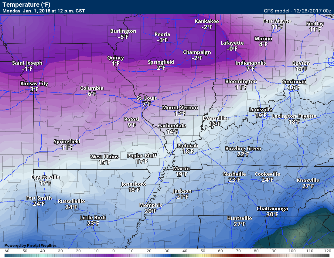
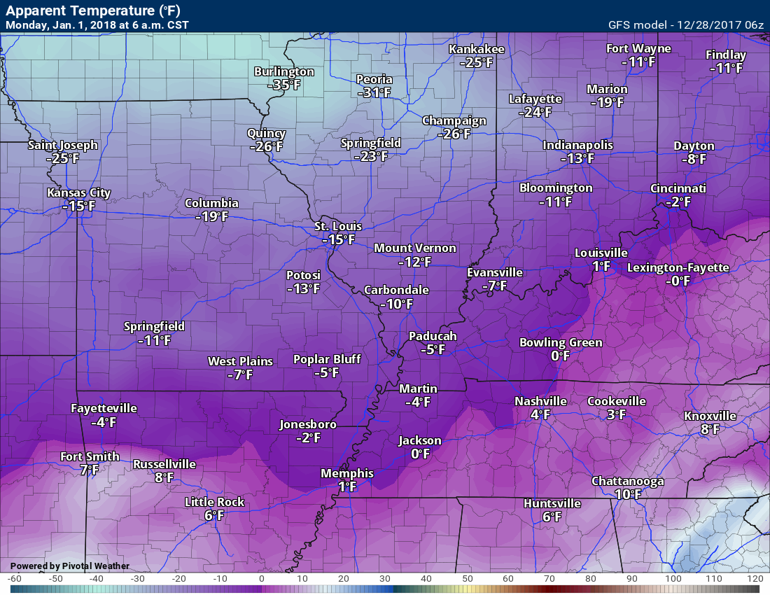
Monday 12 PM temperature anomalies
.
.
And here is the air temperature map for 12 PM Monday
.
.
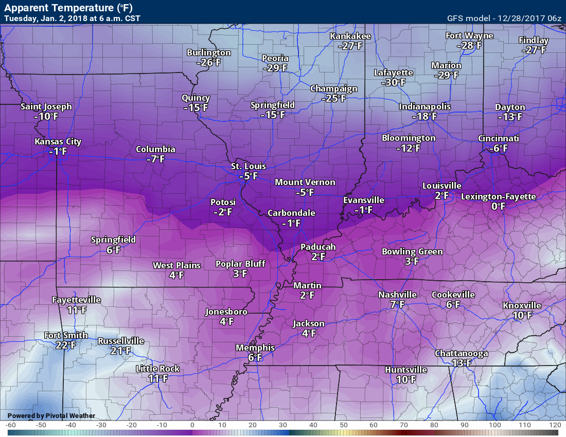
Tuesday 6 AM temperature anomalies
.
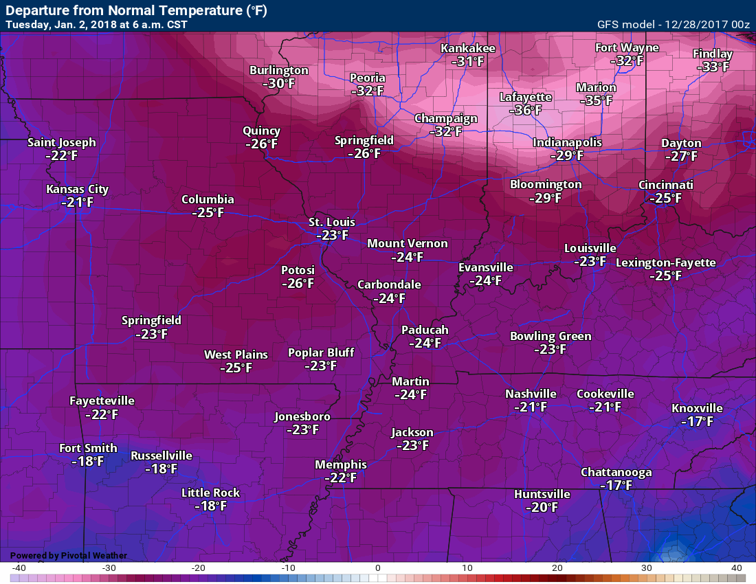
.
And here is the 6 AM Tuesday air temperature map
.
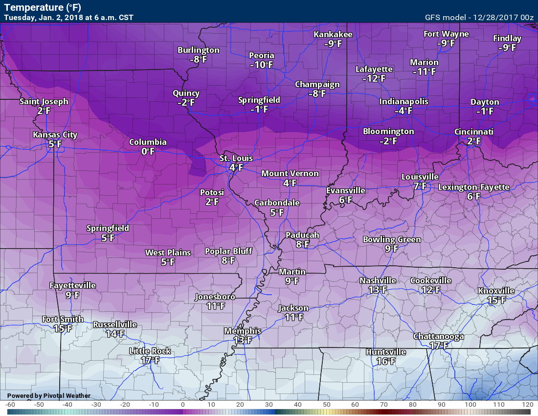
.
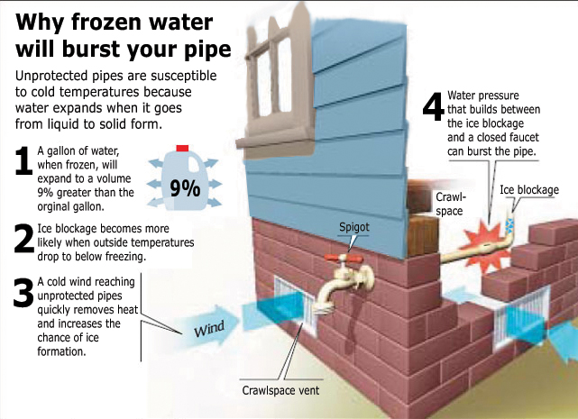
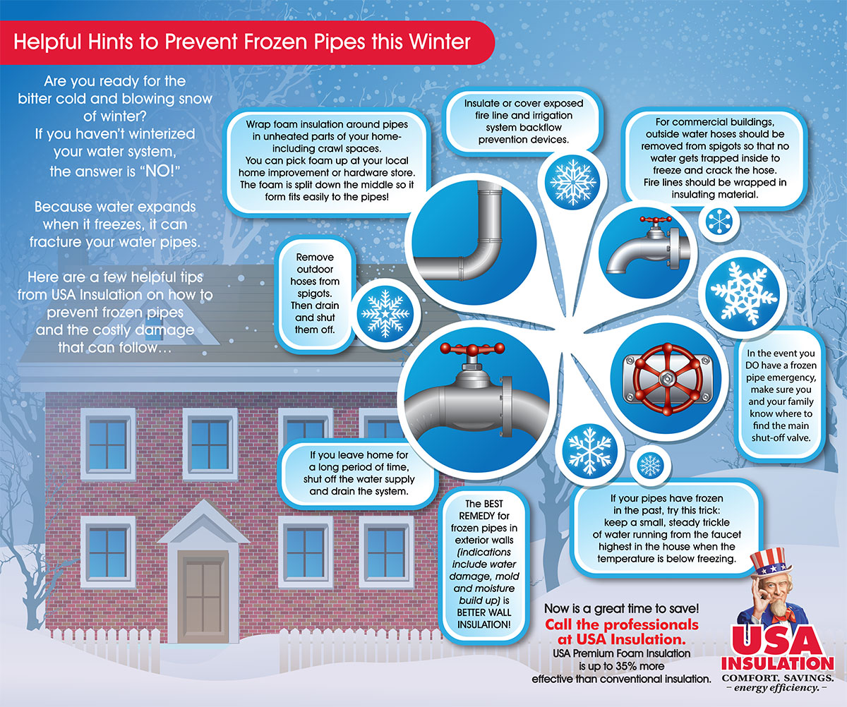
Be aware that this prolonged cold spell could mean broken water lines. Pipes not protected could freeze.
.
.
Click to enlarge

.
Click to enlarge
.
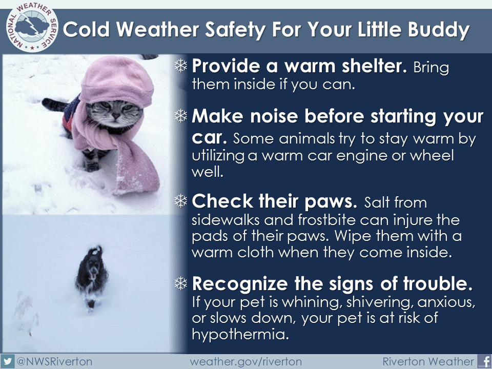
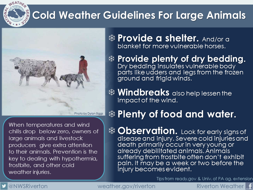
Don’t forget the outdoor animals, as well. This prolonged cold will have an impact on them, as well.
.
.
.
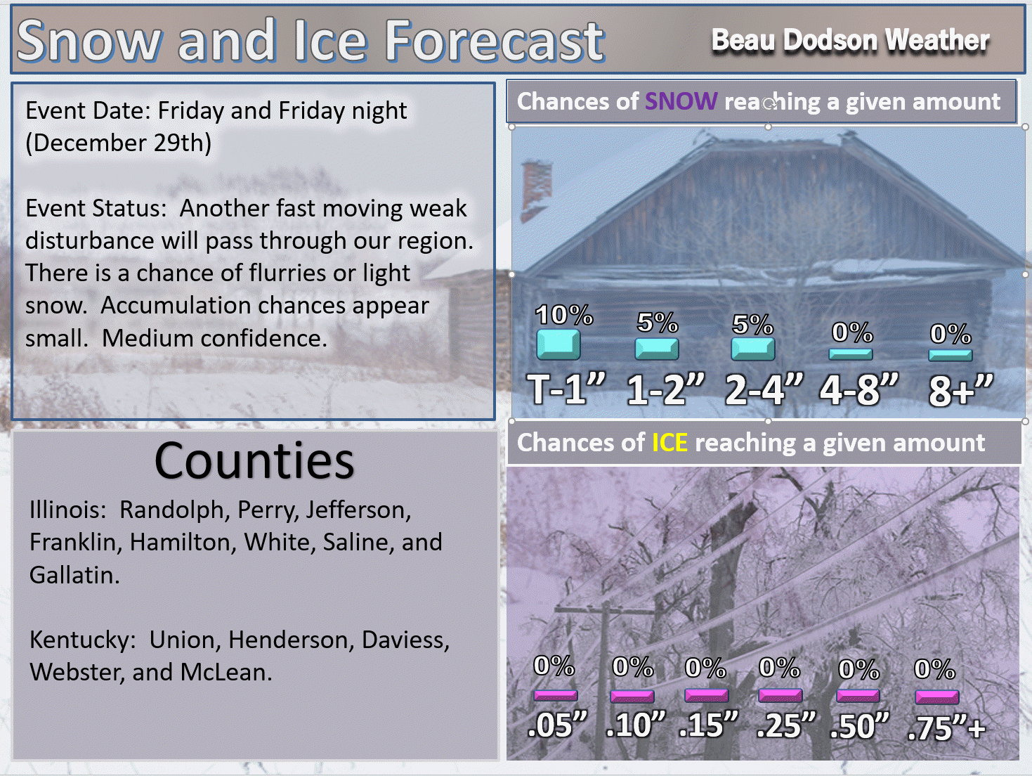
We will have weak disturbances quickly moving in and out of our region over the coming days. These disturbances could produce spotty snow flurries and snow showers.
If one of the disturbances is stronger than anticipated, then a dusting of snow could occur. Confidence in accumulating snow is low.
The weather appears to be mostly dry into next week. Dry and bitterly cold.
Wind chills Saturday into Tuesday will be bitterly cold. Below zero wind chills are likely. Frost bite is a concern.
Saturday wind chills
.
.
Sunday wind chills
.
.
Monday wind chills
.
.
Tuesday wind chills
.
.
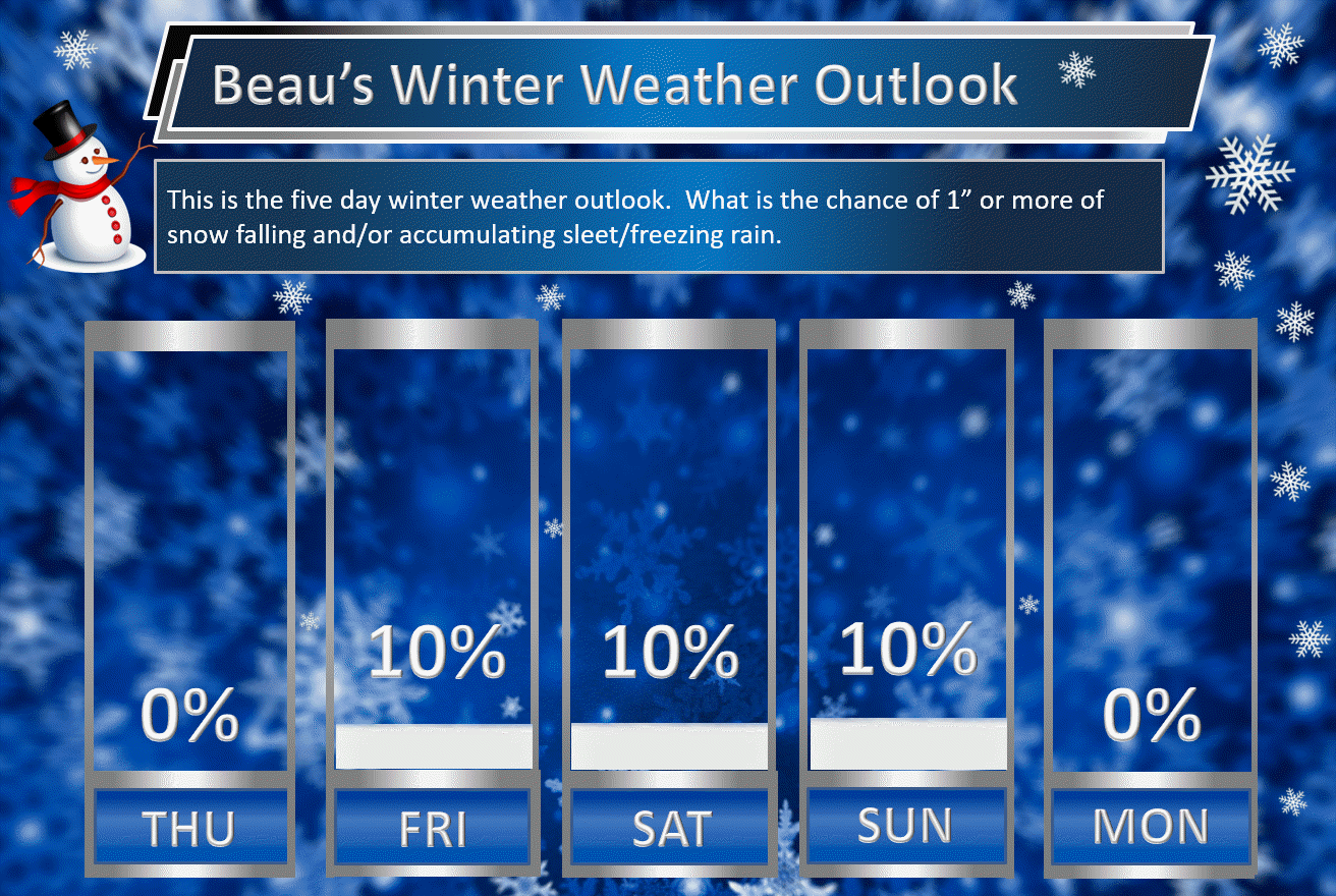
Beau’s Winter Weather Outlook
It is important to remember that this pattern is fluid. There is always going to be lower than normal confidence, during the winter months, for the forecast past day three or four.
.
.
Here are my latest snow probability maps.
Not much to work with. Cold air, but not much moisture.
The counties not listed on the graphic below could also have flurries or snow showers. There is a chance the system could move a tad further south. If that were to happen, then I would need to update these numbers.
.
.
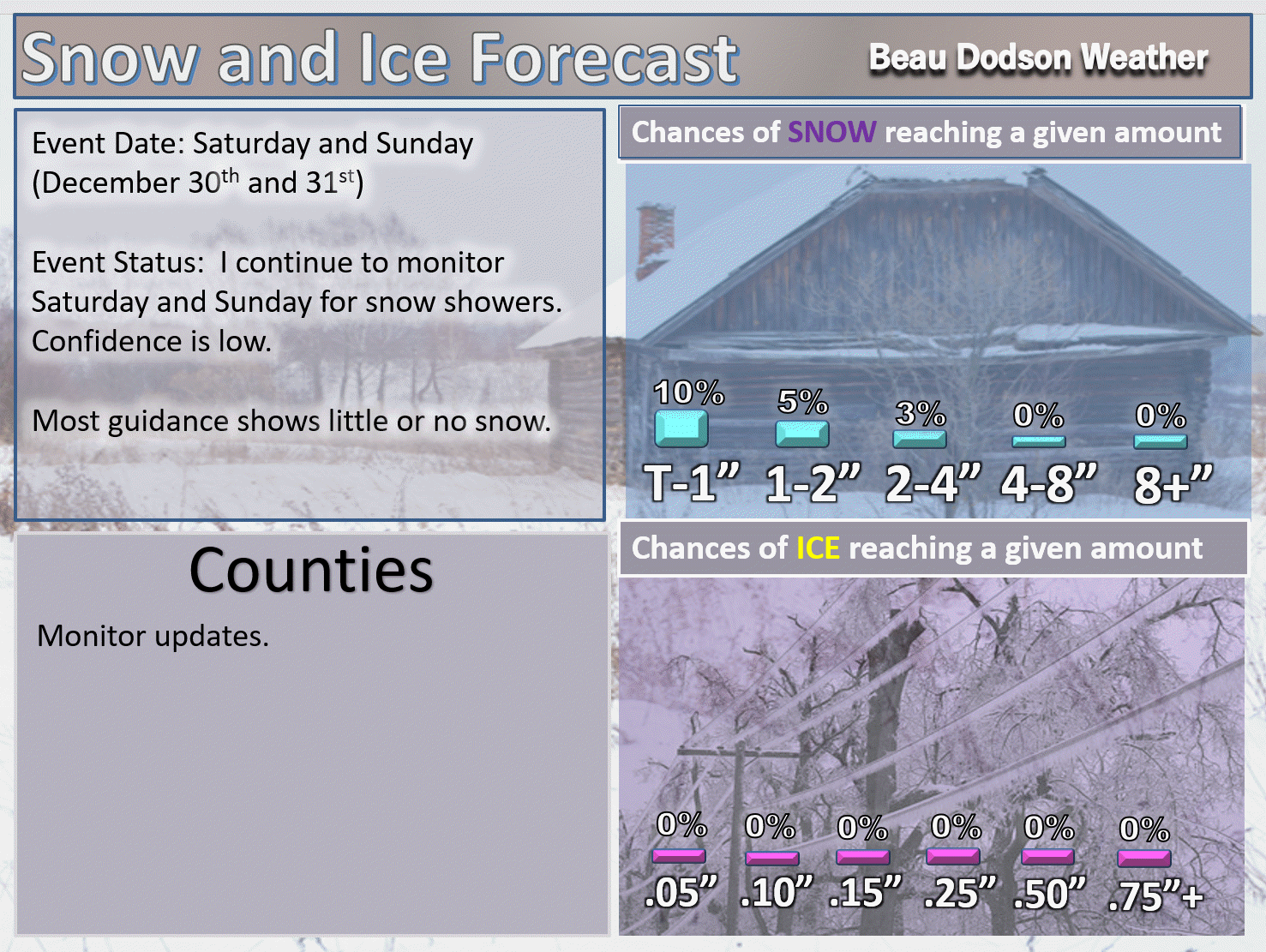
I am monitoring Saturday and Sunday, as well. Low chances for snow. Snow showers or flurries possible. Accumulating snow appears unlikely.
.
.
These have been updated with the latest data.
These graphics show you the % chance of one inch or more of snow and/or accumulating sleet and freezing rain.
.
.

.
Keep in mind, I rarely go above 10% chances past day five. That means 10% is the max number for days six through ten.
.


We offer regional radars and local city radars – if a radar does not update then try another one. Occasional browsers need their cache cleared. You may also try restarting your browser. This will usually fix any problems.
During the winter you can track snow and ice by clicking the winterize button on the local city view interactive radars.
You may email me at beaudodson@usawx.com
Interactive Weather Radar Page. Choose the city nearest your location: Click this link
National interactive radar: Click this link.