
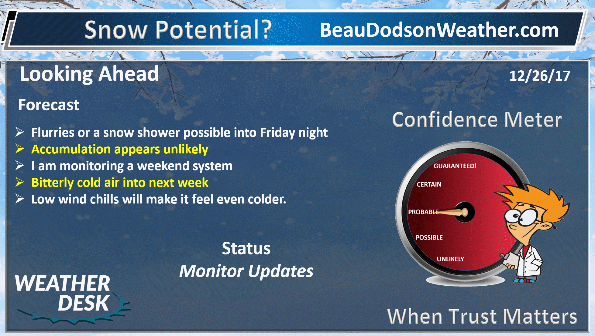
December 26, 2017
.
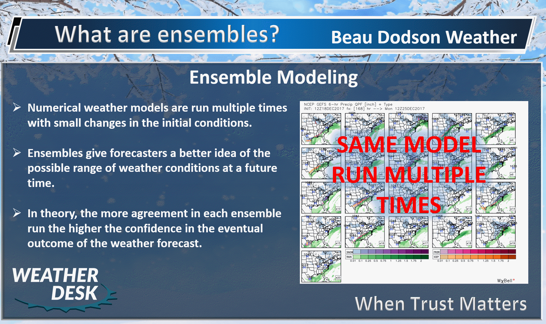
Tuesday Night Forecast Details:
Forecast: Some clouds. A flurry possible. Bitterly cold. Low wind chills.
Temperatures: MO ~ 10 to 15 IL ~ 8 to 14 KY ~ 12 to 16
What is the chance of precipitation? MO ~ 10% IL ~ 10% KY ~ 10%
Coverage of precipitation: None to isolated
Wind chill values: -5 to 15
Accumulating snow or ice: No
Winds: North winds at 5 to 10 mph with gusts to 15
What impacts are anticipated from the weather? Cold wind chills
My confidence in the forecast verifying: High
Is severe weather expected? No
The NWS defines severe weather as 58 mph wind or great, 1″ hail or larger, and/or tornadoes
Should I cancel my outdoor plans: Bitterly cold
.
December 27, 2017
Wednesday Forecast Details
Forecast: Partly to mostly sunny. Cold.
Temperatures: MO ~ 22 to 26 IL ~ 22 to 26 KY ~ 24 to 28
What is the chance of precipitation? MO ~ 10% IL ~ 10% KY ~ 10%
Coverage of precipitation: Most likely none
Wind chill values: 5 above to 20 above
Accumulating snow or ice: No
Winds: North and northeast at 5 to 10 mph
What impacts are anticipated from the weather? Cold wind chills
My confidence in the forecast verifying: High
Is severe weather expected? No
The NWS defines severe weather as 58 mph wind or great, 1″ hail or larger, and/or tornadoes
Should I cancel my outdoor plans? Cold
.
Wednesday Night Forecast Details:
Forecast: Partly cloudy. Cold. Low wind chills.
Temperatures: MO ~ 8 to 14 IL ~ 8 to 12 KY ~ 10 to 15
What is the chance of precipitation? MO ~ 10% IL ~ 10% KY ~ 10%
Coverage of precipitation: Most likely none
Wind chill values: -5 to 10 above
Accumulating snow or ice: Unlikely
Winds: Northeast at 5 to 10 mph
What impacts are anticipated from the weather? Low wind chills.
My confidence in the forecast verifying: High
Is severe weather expected? No
The NWS defines severe weather as 58 mph wind or great, 1″ hail or larger, and/or tornadoes
Should I cancel my outdoor plans: Bitterly cold
.
December 28, 2017
Thursday Forecast Details
Forecast: A mix of sun and clouds.
Temperatures: MO ~ 26 to 32 IL ~ 26 to 32 KY ~ 28 to 34
What is the chance of precipitation? MO ~ 10% IL ~ 10% KY ~ 10%
Coverage of precipitation: Most likely none
Wind chill values: -5 to 15
Accumulating snow or ice: No
Winds: East and northeast at 5 to 10 mph with gusts to 15
What impacts are anticipated from the weather? Low wind chills.
My confidence in the forecast verifying: High
Is severe weather expected? No
The NWS defines severe weather as 58 mph wind or great, 1″ hail or larger, and/or tornadoes
Should I cancel my outdoor plans? Cold
.
Thursday Night Forecast Details:
Forecast: Partly cloudy and cold.
Temperatures: MO ~ 14 to 18 IL ~ 14 to 18 KY ~ 14 to 18
What is the chance of precipitation? MO ~ 10% IL ~ 10% KY ~ 10%
Coverage of precipitation: Most likely none
Wind chill values: -5 to 15
Accumulating snow or ice: No
Winds: North and northwest at 5 to 10 mph
What impacts are anticipated from the weather? Low wind chills.
My confidence in the forecast verifying: High
Is severe weather expected? No
The NWS defines severe weather as 58 mph wind or great, 1″ hail or larger, and/or tornadoes
Should I cancel my outdoor plans: Bitterly cold
.
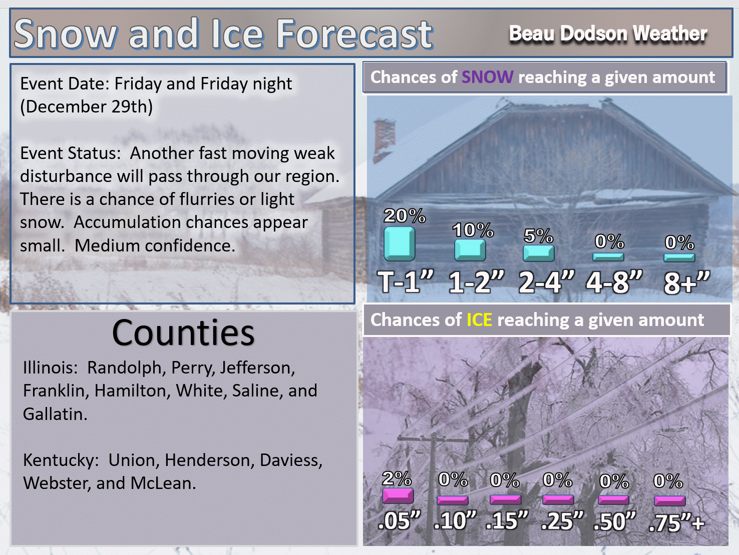
December 29, 2017
Friday Forecast Details
Forecast: Partly sunny morning. Afternoon clouds. A few snow flurries or snow showers possible (esp southern Illinois into northwest Kentucky).
Temperatures: MO ~ 30 to 35 IL ~ 30 to 35 KY ~ 30 to 35
What is the chance of precipitation? MO ~ 10% IL ~ 30% KY ~ 30%
Coverage of precipitation: Isolated over our north and northeast counties
Wind chill values: 15 to 25
Accumulating snow or ice: Monitor updates
Winds: North and northwest at 5 to 10 mph with gusts to 18 mph
What impacts are anticipated from the weather? Cold wind chills. I will monitor the snow chances.
My confidence in the forecast verifying: Medium
Is severe weather expected? No
The NWS defines severe weather as 58 mph wind or great, 1″ hail or larger, and/or tornadoes
Should I cancel my outdoor plans? Cold
.
Friday Night Forecast Details:
Forecast: Cloudy and cold. Flurries or snow showers possible.
Temperatures: MO ~ 16 to 22 IL ~ 16 to 22 KY ~ 16 to 22
What is the chance of precipitation? MO ~ 20% IL ~ 30% KY ~ 30%
Coverage of precipitation: Isolated
Wind chill values: 5 to 15 degrees
Accumulating snow or ice: No
Winds: North at 5 to 10 mph
What impacts are anticipated from the weather? Monitor updates. Cold wind chills.
My confidence in the forecast verifying: Medium
Is severe weather expected? No
The NWS defines severe weather as 58 mph wind or great, 1″ hail or larger, and/or tornadoes
Should I cancel my outdoor plans: Cold
.
LOWER THAN NORMAL CONFIDENCE ON THE WEEKEND FORECAST.
(IF we have snow, then temperatures will be even colder)
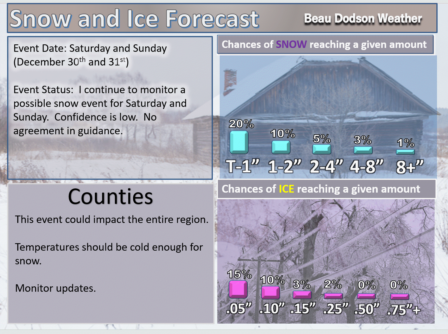
December 30, 2017
Saturday Forecast Details
Forecast: Partly sunny during the morning. Increasing afternoon clouds. I will monitor snow chances.
Temperatures: MO ~ 26 to 32 IL ~ 26 to 32 KY ~ 26 to 32
What is the chance of precipitation? MO ~ 20% IL ~ 20% KY ~ 20%
Coverage of precipitation: Monitor
Wind chill values: 15 to 25
Accumulating snow or ice: Monitor updates
Winds: North and northeast at 6 to 12 mph
What impacts are anticipated from the weather? Low wind chills
My confidence in the forecast verifying: Medium
Is severe weather expected? No
The NWS defines severe weather as 58 mph wind or great, 1″ hail or larger, and/or tornadoes
Should I cancel my outdoor plans? Cold
.
Saturday Night Forecast Details:
Forecast: Cloudy with snow showers possible.
Temperatures: MO ~ 10 to 15 IL ~ 10 to 15 KY ~ 10 to 15
What is the chance of precipitation? MO ~ 30% IL ~ 30% KY ~ 30%
Coverage of precipitation: Monitor updates
Wind chill values: -5 to 15 above
Accumulating snow or ice: Monitor updates
Winds: North at 5 to 10 mph
What impacts are anticipated from the weather? Monitor updates
My confidence in the forecast verifying: Medium
Is severe weather expected? No
The NWS defines severe weather as 58 mph wind or great, 1″ hail or larger, and/or tornadoes
Should I cancel my outdoor plans: Monitor updates
.
December 31, 2017
Sunday Forecast Details
Forecast: Cloudy. Snow showers possible.
Temperatures: MO ~ 20 to 25 IL ~ 20 to 25 KY ~ 23 to 26
What is the chance of precipitation? MO ~ 30% IL ~ 30% KY ~ 30%
Coverage of precipitation: Monitor updates
Wind chill values: -5 to 15 above
Accumulating snow or ice: Monitor updates
Winds: North and northeast at 6 to 12 mph with gusts to 20 mph
What impacts are anticipated from the weather? Monitor updates
My confidence in the forecast verifying: LOW
Is severe weather expected? No
The NWS defines severe weather as 58 mph wind or great, 1″ hail or larger, and/or tornadoes
Should I cancel my outdoor plans? Monitor updates
.
Sunday Night Forecast Details:
Forecast: Cloudy with snow showers possible.
Temperatures: MO ~ 5 to 10 IL ~ 5 to 10 KY ~ 5 to 10
What is the chance of precipitation? MO ~ 20% IL ~ 20% KY ~ 20%
Coverage of precipitation: Monitor updates
Wind chill values: -10 to 10 degrees above
Accumulating snow or ice: Monitor updates
Winds: Northeast and east at 10 to 20 mph
What impacts are anticipated from the weather? Monitor updates
My confidence in the forecast verifying: LOW
Is severe weather expected? No
The NWS defines severe weather as 58 mph wind or great, 1″ hail or larger, and/or tornadoes
Should I cancel my outdoor plans: Monitor updates
.
January 1, 2018
Monday Forecast Details
Forecast: Partly sunny. Cold. Flurries possible.
Temperatures: MO ~ 20 to 25 IL ~ 20 to 25 KY ~ 23 to 26
What is the chance of precipitation? MO ~ 10% IL ~ 10% KY ~ 10%
Coverage of precipitation: Scattered
Wind chill values: -5 to 15 above
Accumulating snow or ice: No
Winds: North and northeast at 6 to 12 mph
What impacts are anticipated from the weather? Cold wind chills.
My confidence in the forecast verifying: Medium
Is severe weather expected? No
The NWS defines severe weather as 58 mph wind or great, 1″ hail or larger, and/or tornadoes
Should I cancel my outdoor plans? Cold
.
Monday Night Forecast Details:
Forecast: Mostly clear and bitterly cold.
Temperatures: MO ~ 0 to 8 IL ~ 0 to 8 KY ~ 4 to 8 above
What is the chance of precipitation? MO ~ 0% IL ~ 0% KY ~ 0%
Coverage of precipitation: Most likely none
Wind chill values: -15 to 5 degrees above
Accumulating snow or ice: No
Winds: North winds at 5 to 10 mph with gusts to 14
What impacts are anticipated from the weather? Cold wind chills
My confidence in the forecast verifying: Medium
Is severe weather expected? No
The NWS defines severe weather as 58 mph wind or great, 1″ hail or larger, and/or tornadoes
Should I cancel my outdoor plans: Cold
.

.
Tuesday night through Friday night: Medium to high confidence. Accumulating snow or ice is unlikely. Snow showers are possible from time to time with a dusting or less of accumulation.
Saturday into Monday: Low confidence. A cold front will pass through the region. This could produce snow, but confidence is low. It will be bitterly cold.
.

.
The National Weather Service definition of a severe thunderstorm is one that produces quarter size hail or larger, 58 mph winds or greater, and/or a tornado.
Now through next Wednesday: Severe storms are not anticipated.
.

Forecast
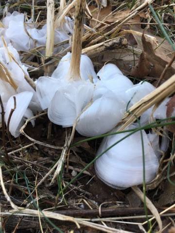
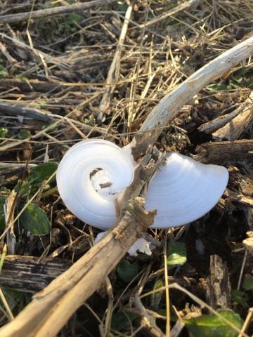
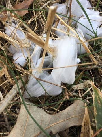
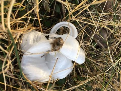
Check out these Tuesday morning ice flowers in Symsonia, Kentucky. Photos taken by Renee Power Koehler
.
.
Formation. The formation of frost flowers is dependent on a freezing weather condition occurring when the ground is not already frozen. The sap in the stem of the plants will expand (water expands when frozen), causing long, thin cracks to form along the length of the stem.
Some concerning temperature data in the charts over the coming ten days.
There is the potential for bitterly cold air to cause problems in the region. Snow is also a possibility. The snow chances, however, are still low confidence.
I would advise everyone to monitor updated forecasts over the coming days.
Interactive Weather Radar Page. Choose the city nearest your location: Click this link
Tonight into Friday
Cold weather will be with us into next week.
Clouds will be with us into the coming days. Occasionally a mix of sun and clouds. Accumulating snow is unlikely. I suppose a snow shower could briefly dust the ground in a few spots.
Wednesday might deliver the most sunshine. It won’t help temperatures.
A weak disturbance this afternoon and tonight could produce a few light flurries or snow showers.
Organized winter weather is unlikely through Friday afternoon.
A weak disturbance on Thursday and Thursday night could produce a few flurries or snow showers.
At one time the Thursday system appeared that it might deliver a widespread precipitation event. For now, that seems unlikely.
Moisture is lacking for a larger snow event on Thursday.
A weak system will skirt our northern counties on Friday and Friday night. Snow showers or flurries are again possible with the disturbance. It appears unlikely there would be accumulation, but I will keep an eye on it.
Temperatures
Temperatures will remain below to well below normal into at least the middle of next week and perhaps longer.
Highs on Wednesday, Thursday, and Friday will remain in the upper 20’s to middle 30’s. Highs on Saturday and Sunday will mostly be in the 20’s.
Highs on New Year’s Day will remain in the teens and 20’s (unless we have snow cover).
Overnight lows tonight will be in the teens. Same for Wednesday and Thursday night. As a matter of fact, the lows on Thursday morning could dip into the upper single digits to lower teens.
Lows on Friday morning will be in the teens. Lows on Saturday and Sunday morning will be in the upper single digits to lower teens. Brrr
Some of the guidance takes us below zero next week for overnight lows.
If we have snow Sunday and Sunday night then sub-zero temperatures will be almost certain. The chance of snow, however, is questionable.
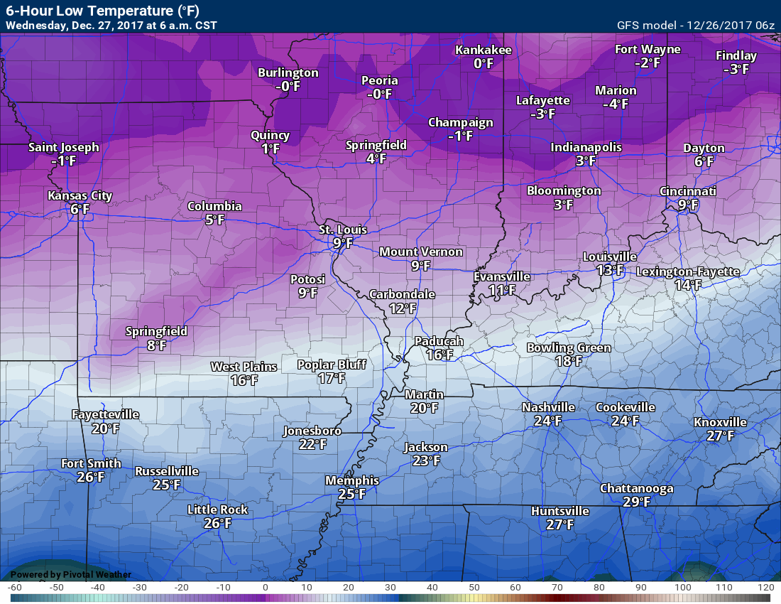
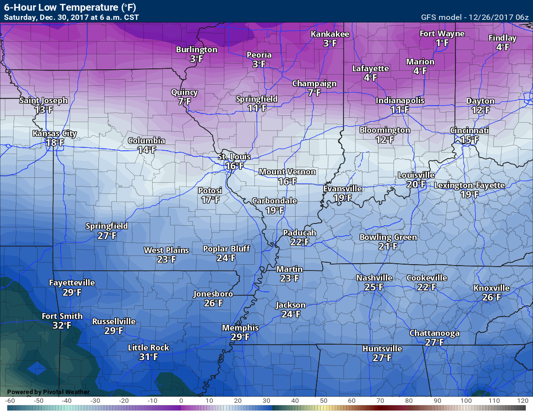
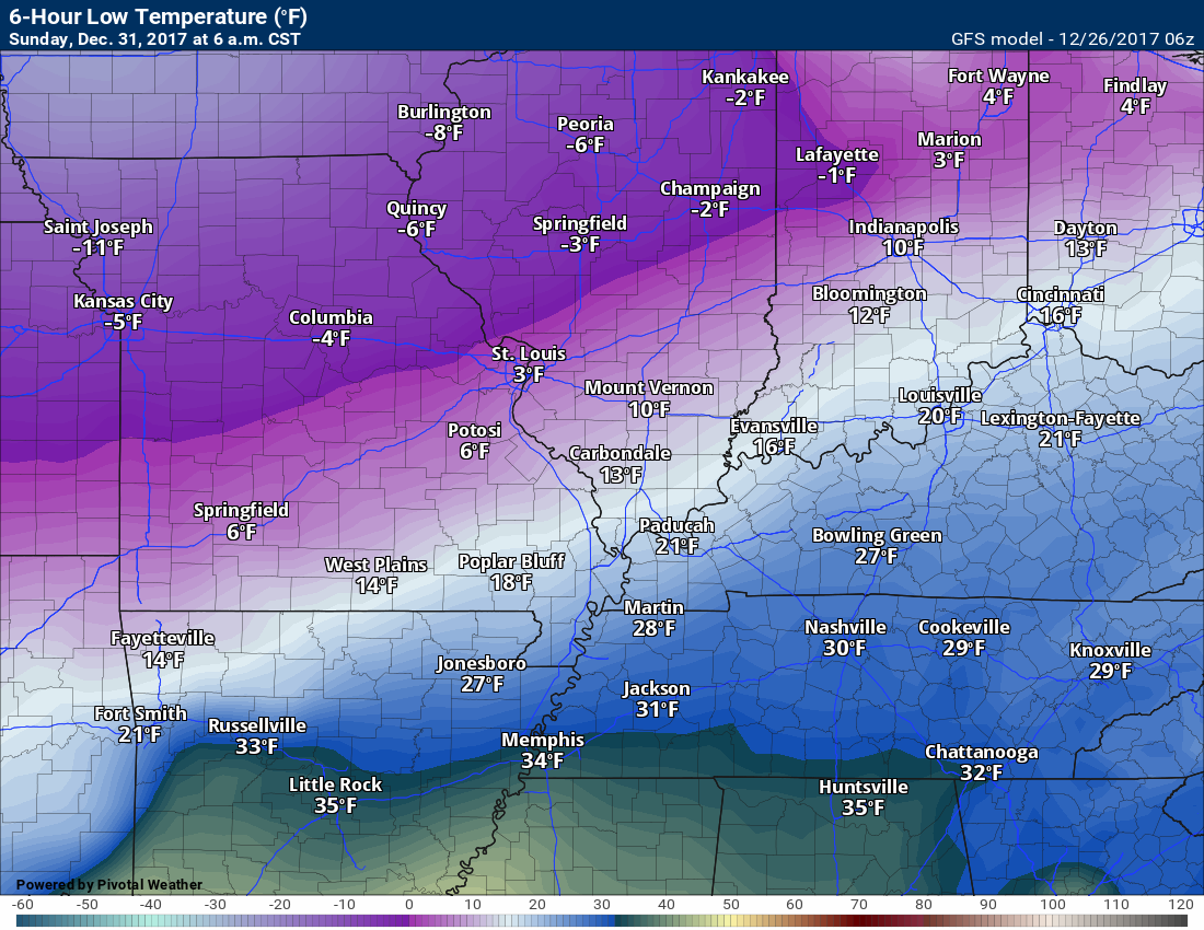
Let me show you the GFS model guidance low temperature forecast for the coming days.
Wednesday morning
.
.
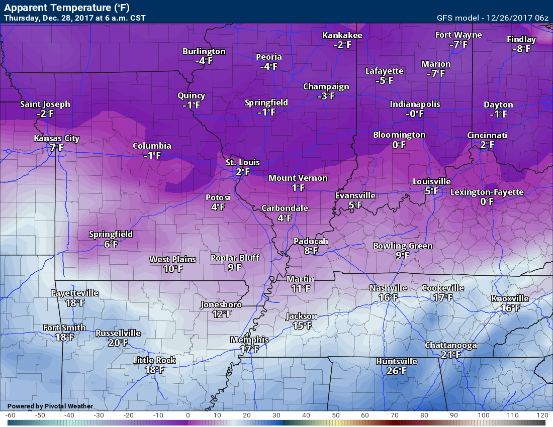
Thursday morning
.

.
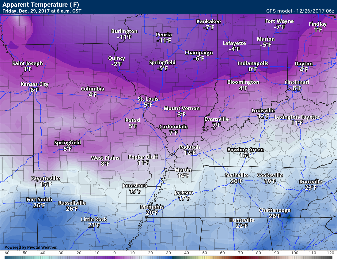
Friday morning
.

.
Saturday morning
.
.
Sunday morning
.
.
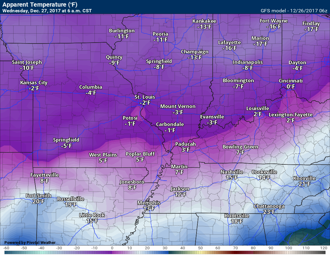
Wind Chills
It is going to be quite cold over the coming days (see daily forecast bottom of this post)
Wind chills tonight into Thursday morning could dip below zero to ten above. Bitterly cold air. At least the kids aren’t in school. Either way, be aware of the cold temperatures. Frost bite can occur in a short amount of time to exposed fingers and other body parts.
Wind chills will remain cold into next week.
Here are some of the colder wind chills maps.
The coldest temperatures will occur during the overnight hours into the morning hours.
Wednesday morning wind chills
.
.
Thursday morning wind chills
.
.
Friday morning wind chills
.
.
Models show even colder wind chills by Sunday into Wednesday. WELL below zero on some of the charts. Monitor updates.
Snow chances
I can’t rule out light snow flurries or showers periodically over the coming days. Measurable snow appears unlikely through Friday night.
A stronger system could bring widespread snow to the region on Saturday afternoon into Sunday, but confidence in that happening is low. Models are not in agreement, again.
Many National Weather Service Offices have thrown out the models showing snow.
I would not count out the potential for accumulating snow on Saturday afternoon into Sunday night. Confidence is low, for now.
There will be an arctic cold front in the region this weekend. Along with the front will be several upper level disturbances. These could produce snow.
If we do have snow, then actual air temperatures will dip below zero next week. Monitor updates.
Let’s look at some charts.
.
.
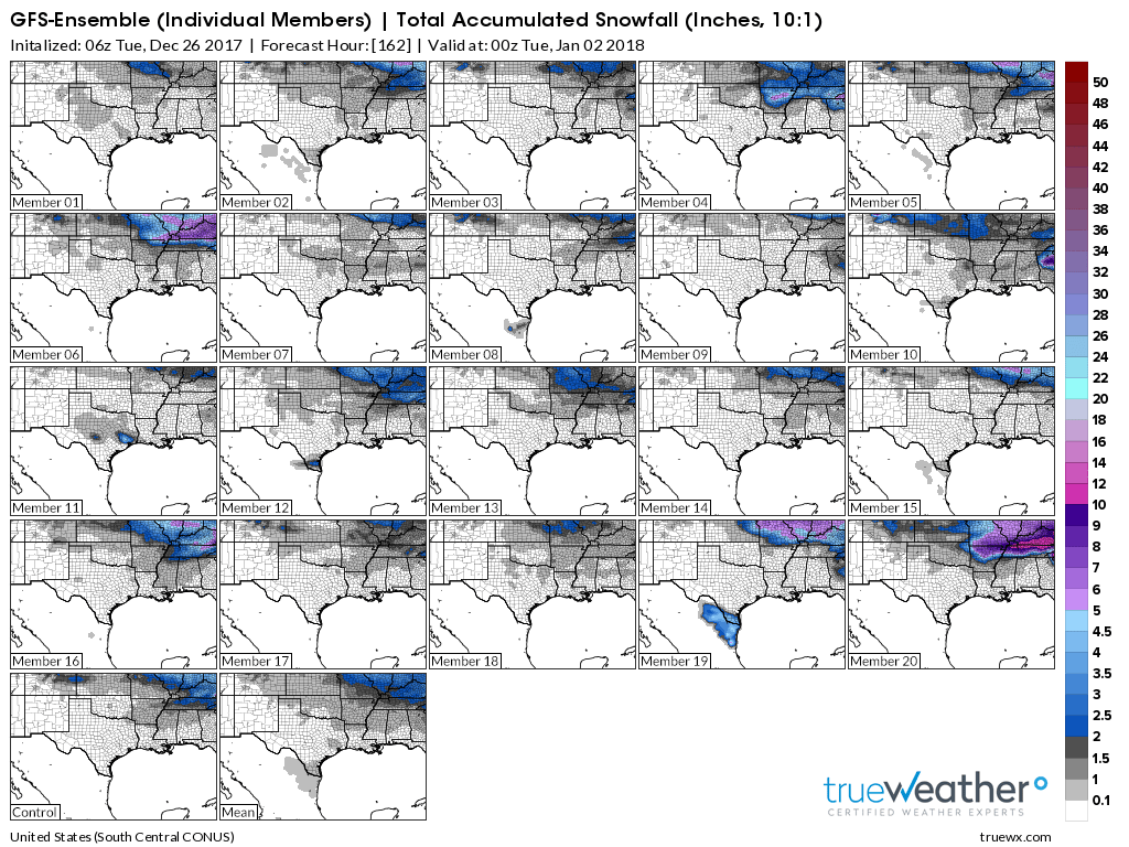
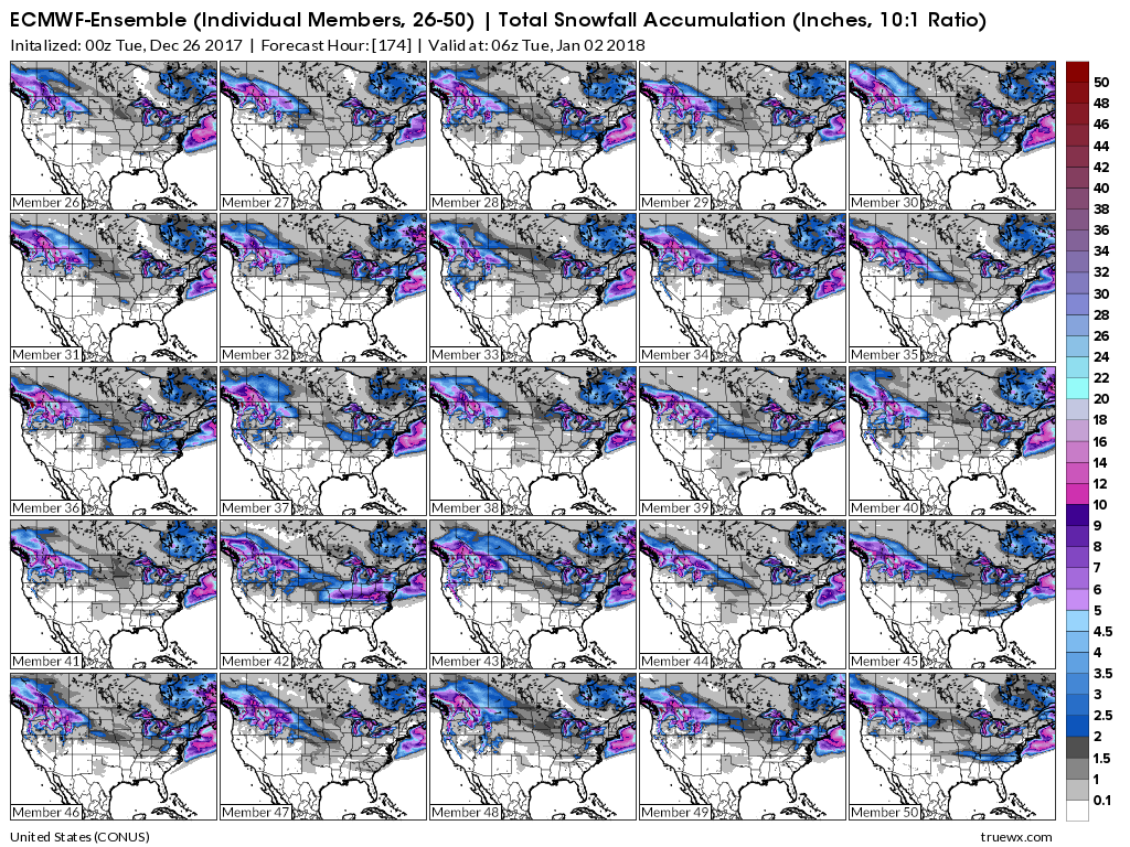
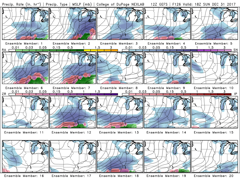
Here are the GFS snow ensembles
Click to enlarge the images on this page. The colors represent snow totals.
This first set of ensembles is through New Years Day. Several ensemble members are indicating the potential for accumulating snow. Some of them show heavy snow.
Again, this is just a tool that I can use to determine if the model is actually on to something. The GFS is bullish for snow this weekend and early next week.
Monitor updated forecasts.
Each square is one ensemble member. The colors represent snow totals.
.
.
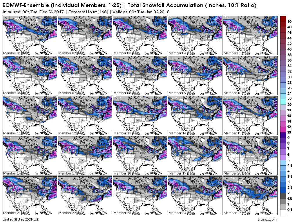
Let’s look at the EC model. The European guidance.
The EC guidance, on the other hand, does not show the potential for snow this coming week or early next week. It keeps the region dry.
Each one of these squares is one ensemble member. The colors represent snow totals.
.
.
Let’s look at the operational model guidance. The operational guidance is the main run of each model.
Here is the GFS guidance. Blue is snow. Green is rain.
The GFS paints some light snow or flurries on Friday night. At this time, moisture appears limited.
This would mainly be our northern counties and perhaps into northwest Kentucky. Confidence in accumulating snow is low. There just isn’t much moisture available to tap into. See the snow probability chart below.
As always monitor updates.
.
Here are the snow probabilities for Friday into Friday night. Weak system. Low potential. Medium confidence in the forecast.
.
.
The next system of interest will arrive Saturday afternoon into Sunday. Low confidence on this one. Most of the models show little or no snow.
Once again the models do not agree on how this system unfolds.
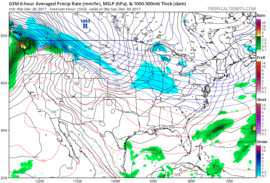
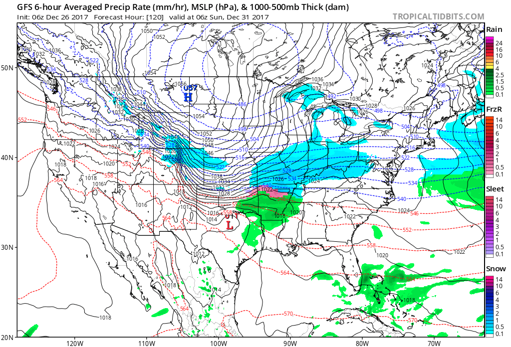
Here is what the GFS operational model is showing
Saturday at 6 PM. Blue is snow. Pink is ice. Green is rain.
The GFS is the only model showing snow.
This is Saturday at 6 PM
.

.
This next map is Sunday at 12 AM. This is the GFS model. It is the outlier, at this point.
.
.
A number of the GFS ensembles have the Saturday/Sunday system. This adds to the uncertainty.
.
.
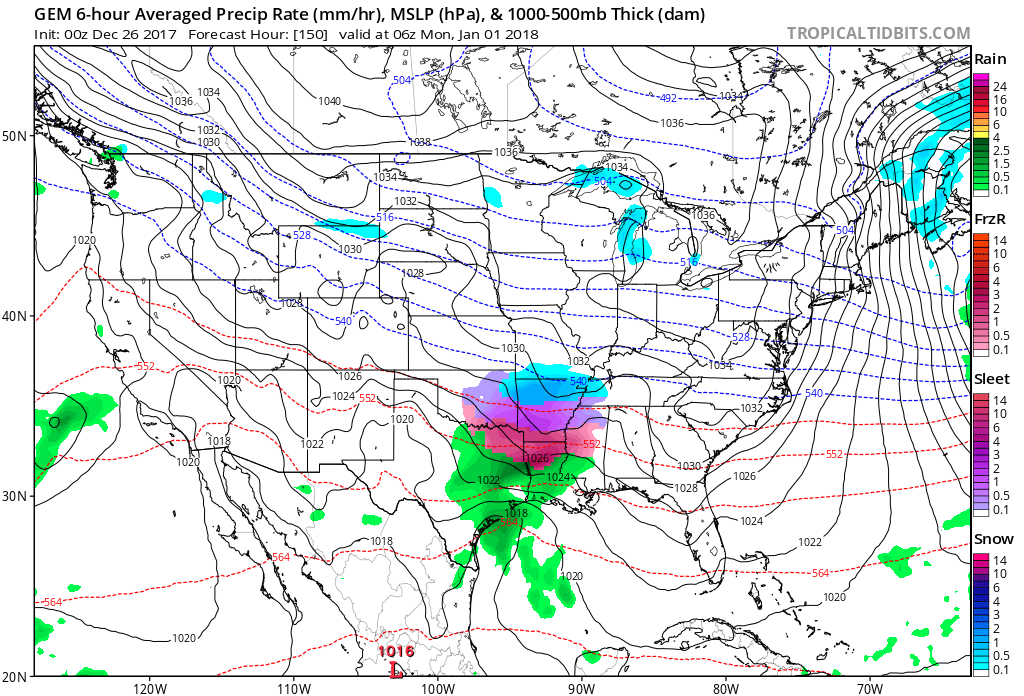
Meanwhile the Canadian model holds precipitation chances off until Sunday night. It brings a southern system into the region. Brushing us. The Canadian model keeps most of the snow to our south.
.
.
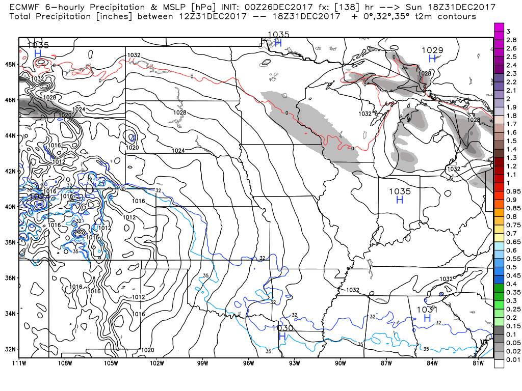
And finally, here is the EC guidance for Saturday night/Sunday
.
Big differences in the guidance.
EC is dry as a bone.
.
.
Here is the probability map for Saturday into Sunday. Monitor updates for changes in the forecast.
.
.
Beau’s Winter Weather Outlook
It is important to remember that this pattern is fluid. There is always going to be lower than normal confidence, during the winter months, for the forecast past day three or four.
.
.


We offer regional radars and local city radars – if a radar does not update then try another one. Occasional browsers need their cache cleared. You may also try restarting your browser. This will usually fix any problems.
During the winter you can track snow and ice by clicking the winterize button on the local city view interactive radars.
You may email me at beaudodson@usawx.com
Interactive Weather Radar Page. Choose the city nearest your location: Click this link
National interactive radar: Click this link.