.

Click one of the links below to take you directly to that section.
Do you have any suggestions or comments? Email me at beaudodson@usawx.com
A quick glance at the next seven days.


.
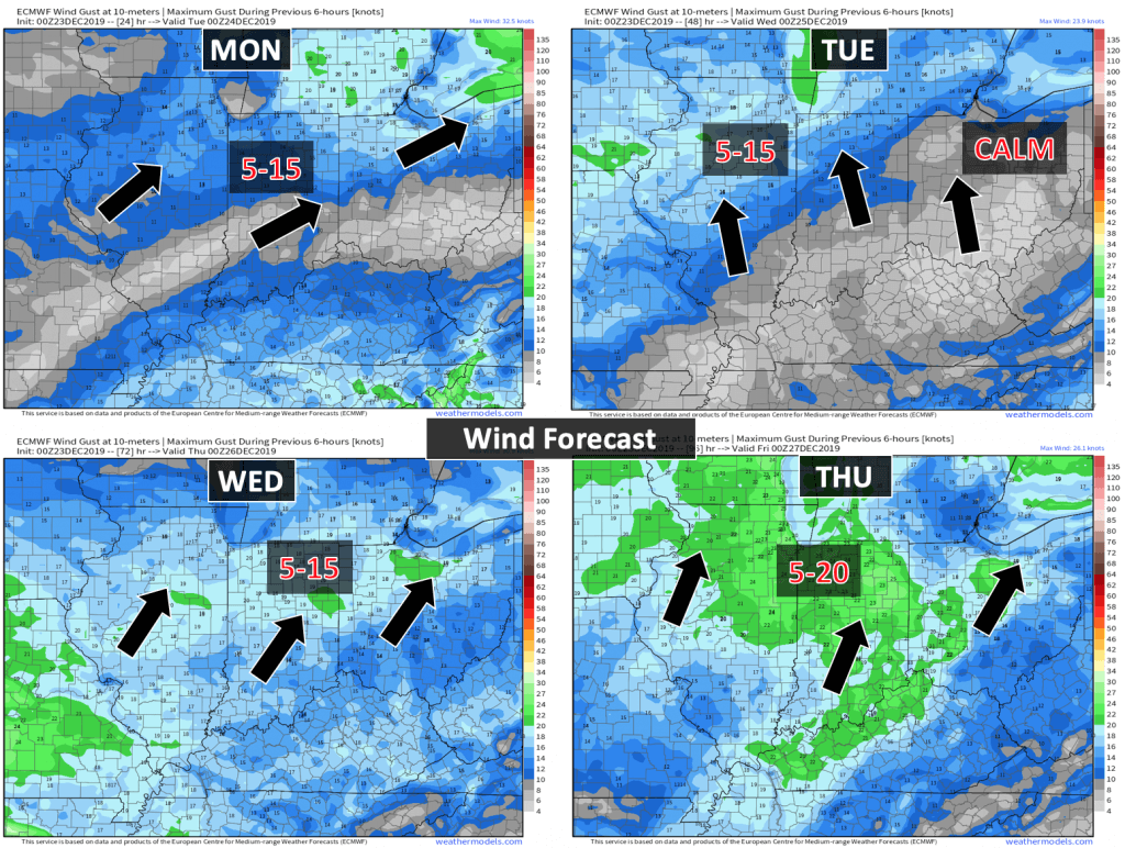
The wind forecast

.
Tuesday through Monday
- Is lightning in the forecast? Yes. The highest chance of lightning will arrive on Saturday.
- Are severe thunderstorms in the forecast? Monitor. I am closely watching Saturday and Saturday night for the potential of strong thunderstorms.
* The NWS officially defines a severe thunderstorm as a storm with 58 mph wind or greater, 1″ hail or larger, and/or tornadoes - Is flash flooding in the forecast? Not at this time.
- Is ACCUMULATING snow or ice in the forecast? No.
- Will wind chill values drop below 10 degrees? No
.
..
.
What changes might occur in the forecast?
Timing of the highest rain chances Friday into Saturday night.
.
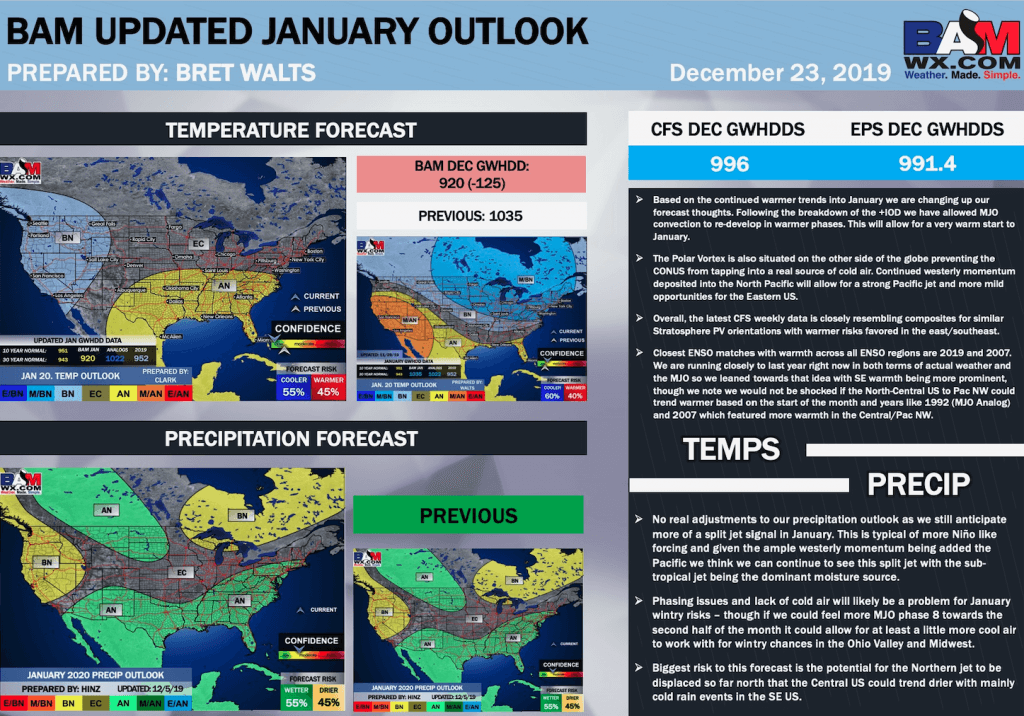
December 24, 2019
How confident am I that this days forecast will verify? High confidence.
Tuesday’s Forecast: Patchy morning fog. Partly cloudy. Warm for December.
What is the chance of precipitation? MO ~ 0% IL ~ 0% KY ~ 0% TN ~ 0%
Temperature range: MO Bootheel 64° to 66° SE MO 64° to 66° South IL 63° to 66° Northwest KY (near Indiana border) 63° to 65° West KY 63° to 66° NW TN 63° to 66°
Wind direction and speed: South at 4 to 8 mph
Wind chill or heat index (feels like) temperature forecast: 62° to 66°
Coverage of precipitation: None
What impacts are anticipated from the weather? None
Should I cancel my outdoor plans? No
UV Index: 2 Low
Sunrise: 7:07 AM
Sunset: 4:42 PM
.
Tuesday night Forecast: Partly cloudy.
What is the chance of precipitation? MO ~ 0% IL ~ 0% KY ~ 0% TN ~ 0%
Temperature range: MO Bootheel 42° to 44° SE MO 40° to 45° South IL 40° to 45° Northwest KY (near Indiana border) 40° to 44° West KY 40° to 45° NW TN 42° to 45°
Wind direction and speed: Southeast at 5 mph
Wind chill or heat index (feels like) temperature forecast: 40° to 45°
Coverage of precipitation: None
What impacts are anticipated from the weather? None
Should I cancel my outdoor plans? No
Moonrise: 5:27 AM
Moonset: 3:37 PM
The phase of the moon: Waning Crescent
.
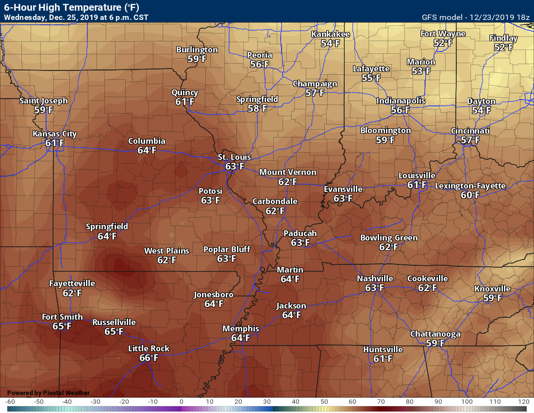
December 25, 2019
How confident am I that this days forecast will verify? High confidence.
Wednesday’s Forecast: Partly sunny and warm for December.
What is the chance of precipitation? MO ~ 0% IL ~ 0% KY ~ 0% TN ~ 0%
Temperature range: MO Bootheel 66° to 68° SE MO 66° to 68° South IL 66° to 68° Northwest KY (near Indiana border) 66° to 68° West KY 66° to 68° NW TN 66° to 68°
Wind direction and speed: South and southwest at 7 to 14 mph
Wind chill or heat index (feels like) temperature forecast: 64° to 68°
Coverage of precipitation: None
What impacts are anticipated from the weather? None
Should I cancel my outdoor plans? No
UV Index: 2 Low
Sunrise: 7:08 AM
Sunset: 4:43 PM
.
Wednesday night Forecast: Partly cloudy.
What is the chance of precipitation? MO ~ 0% IL ~ 0% KY ~ 0% TN ~ 0%
Temperature range: MO Bootheel 48° to 52° SE MO 48° to 52° South IL 48° to 52° Northwest KY (near Indiana border) 48° to 52° West KY 48° to 52° NW TN 48° to 52°
Wind direction and speed: South at 5 mph
Wind chill or heat index (feels like) temperature forecast: 46° to 50°
Coverage of precipitation: None
What impacts are anticipated from the weather? None
Should I cancel my outdoor plans? No
Moonrise: 6:31 AM
Moonset: 4:24 PM
The phase of the moon: Waning Crescent
.
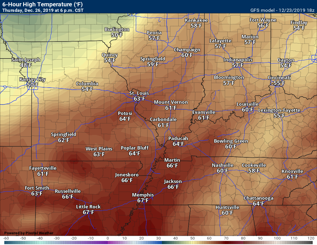
December 26, 2019
How confident am I that this days forecast will verify? High confidence.
Thursday’s Forecast: Quite a few clouds.
What is the chance of precipitation? MO ~ 0% IL ~ 0% KY ~ 0% TN ~ 0%
Temperature range: MO Bootheel 60° to 65° SE MO 60° to 65° South IL 60° to 65° Northwest KY (near Indiana border) 60° to 65° West KY 60° to 65° NW TN 60° to 65°
Wind direction and speed: South and southwest at 5 to 10 mph
Wind chill or heat index (feels like) temperature forecast: 60° to 65°
Coverage of precipitation: None
What impacts are anticipated from the weather? None
Should I cancel my outdoor plans? No
UV Index: 2 Low
Sunrise: 7:08 AM
Sunset: 4:43 PM
.
Thursday night Forecast: Cloudy.
What is the chance of precipitation? MO ~ 0% IL ~ 0% KY ~ 0% TN ~ 0%
Temperature range: MO Bootheel 43° to 46° SE MO 42° to 44° South IL 42° to 44° Northwest KY (near Indiana border) 42° to 44° West KY 42° to 44° NW TN 42° to 45°
Wind direction and speed: Becoming south at 5 mph
Wind chill or heat index (feels like) temperature forecast: 42° to 45°
Coverage of precipitation: None
What impacts are anticipated from the weather? None
Should I cancel my outdoor plans? No
Moonrise: 7:31 AM
Moonset: 5:18 PM
The phase of the moon: New
.
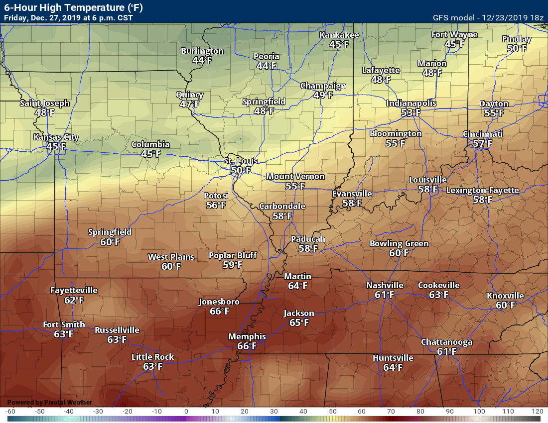
December 27, 2019
How confident am I that this days forecast will verify? High confidence.
Friday’s Forecast: Cloudy.
What is the chance of precipitation? MO ~ 30% IL ~ 20% KY ~ 20% TN ~ 20%
Temperature range: MO Bootheel 56° to 60° SE MO 55° to 60° South IL 54° to 58° Northwest KY (near Indiana border) 56° to 60° West KY 58° to 60° NW TN 58° to 60°
Wind direction and speed: South at 7 to 14 mph
Wind chill or heat index (feels like) temperature forecast: 54° to 58°
Coverage of precipitation: Most likely none
What impacts are anticipated from the weather? None
Should I cancel my outdoor plans? No
UV Index: 1 Low
Sunrise: 7:08 AM
Sunset: 4:44 PM
.
Friday night Forecast: Cloudy with scattered showers.
What is the chance of precipitation? MO ~ 30% IL ~ 30% KY ~ 30% TN ~ 30%
Temperature range: MO Bootheel 44° to 46° SE MO 43° to 46° South IL 43° to 46° Northwest KY (near Indiana border) 43° to 46° West KY 43° to 46° NW TN 43° to 46°
Wind direction and speed: Northeast at 5 mph
Wind chill or heat index (feels like) temperature forecast: 42° to 45°
Coverage of precipitation: Scattered after midnight
What impacts are anticipated from the weather? Wet roadways.
Should I cancel my outdoor plans? No
Moonrise: 8:24 AM
Moonset: 6:15 PM
The phase of the moon: New
.
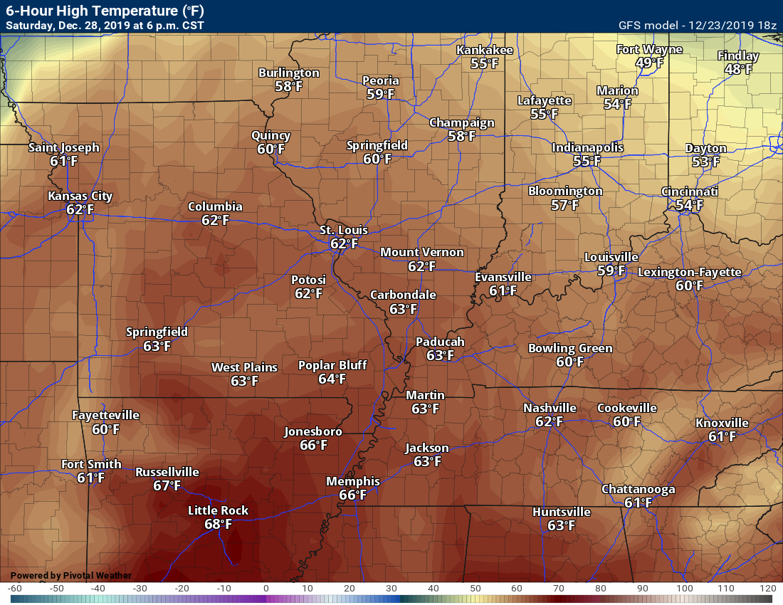
December 28, 2019
How confident am I that this days forecast will verify? High confidence.
Saturday’s Forecast: Cloudy with a chance of showers and thunderstorms.
What is the chance of precipitation? MO ~ 60% IL ~ 60% KY ~ 60% TN ~ 60%
Temperature range: MO Bootheel 58° to 62° SE MO 58° to 62° South IL 58° to 62° Northwest KY (near Indiana border) 58° to 62° West KY 58° to 62° NW TN 58° to 64°
Wind direction and speed: South at 8 to 16 mph
Wind chill or heat index (feels like) temperature forecast: 58° to 64°
Coverage of precipitation: Numerous
What impacts are anticipated from the weather? Wet roadways. Lightning,
Should I cancel my outdoor plans? Have a plan B and monitor updates
UV Index: 2 Low
Sunrise: 7:09 AM
Sunset: 4:45 PM
.
Saturday night Forecast: Cloudy with a chance of showers and thunderstorms. Turning colder.
What is the chance of precipitation? MO ~ 60% IL ~ 60% KY ~ 60% TN ~ 60%
Temperature range: MO Bootheel 44° to 46° SE MO 43° to 46° South IL 43° to 46° Northwest KY (near Indiana border) 43° to 46° West KY 43° to 46° NW TN 43° to 46°
Wind direction and speed: South and southwest at 8 to 16 mph becoming northwest
Wind chill or heat index (feels like) temperature forecast: 42° to 45°
Coverage of precipitation: Numerous
What impacts are anticipated from the weather? Wet roadways. Lightning.
Should I cancel my outdoor plans? Have a plan B
Moonrise: 9:12 AM
Moonset: 7:14 PM
The phase of the moon: Waxing Crescent
.
December 29, 2019
How confident am I that this days forecast will verify? High confidence.
Sunday’s Forecast: Cloudy. A chance of showers.
What is the chance of precipitation? MO ~ 30% IL ~ 30% KY ~ 30% TN ~ 30%
Temperature range: MO Bootheel 54° to 58° SE MO 53° to 56° South IL 53° to 56° Northwest KY (near Indiana border) 53° to 56° West KY 53° to 56° NW TN 53° to 56°
Wind direction and speed: Northwest at 8 to 16 mph becoming variable in direction
Wind chill or heat index (feels like) temperature forecast: 50° to 55°
Coverage of precipitation: Scattered
What impacts are anticipated from the weather? Wet roadways.
Should I cancel my outdoor plans? Monitor updates.
UV Index: 2 Low
Sunrise: 7:09 AM
Sunset: 4:46 PM
.
Sunday night Forecast: Cloudy and turning colder. A slight chance of showers.
What is the chance of precipitation? MO ~ 10% IL ~ 10% KY ~ 10% TN ~ 10%
Temperature range: MO Bootheel 34° to 38° SE MO 33° to 36° South IL 33° to 36° Northwest KY (near Indiana border) 34° to 36° West KY 34° to 36° NW TN 34° to 38°
Wind direction and speed: Variable at 6 to 12 mph and gusty
1Wind chill or heat index (feels like) temperature forecast: 30° to 35°
Coverage of precipitation: Isolated
What impacts are anticipated from the weather? Wet roadways.
Should I cancel my outdoor plans? No
Moonrise: 9:50 am
Moonset: 8:13 pm
The phase of the moon: Waxing Crescent
.
December 30, 2019
How confident am I that this days forecast will verify? High confidence.
Monday’s Forecast: Mostly sunny. Cooler.
What is the chance of precipitation? MO ~ 0% IL ~ 0% KY ~ 0% TN ~ 0%
Temperature range: MO Bootheel 45° to 50° SE MO 45° to 50° South IL 45° to 50° Northwest KY (near Indiana border) 45° to 50° West KY 45° to 50° NW TN 48° to 50°
Wind direction and speed: North wind at 7 t0 14 mph
Wind chill or heat index (feels like) temperature forecast: 45° to 50°
Coverage of precipitation: None
What impacts are anticipated from the weather? None.
Should I cancel my outdoor plans? No
UV Index: 2 Low
Sunrise: 7:09 AM
Sunset: 4:46 PM
.
Monday night Forecast: Mostly clear. Chilly.
What is the chance of precipitation? MO ~ 0% IL ~ 0% KY ~ 0% TN ~ 0%
Temperature range: MO Bootheel 34° to 38° SE MO 33° to 36° South IL 33° to 36° Northwest KY (near Indiana border) 34° to 36° West KY 34° to 36° NW TN 34° to 38°
Wind direction and speed:
1Wind chill or heat index (feels like) temperature forecast: 30° to 35°
Coverage of precipitation: None
What impacts are anticipated from the weather? None
Should I cancel my outdoor plans? No
Moonrise: 10:24 am
Moonset: 9:12 pm
The phase of the moon: Waxing Crescen
.

.
- Damp conditions Friday night into Saturday night/Sunday morning.
.
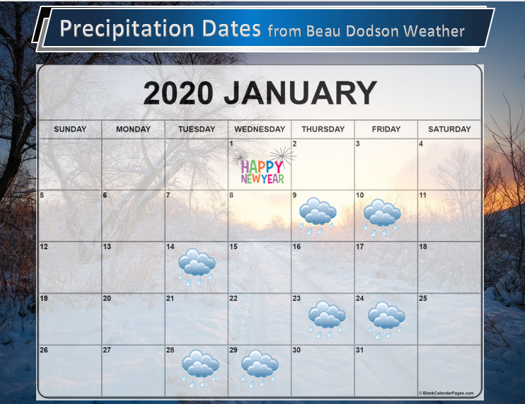
These are dates that may have precipitation. Monitor the trends in the forecast.
Anything past day seven is low confidence.
The icon can mean rain or snow.
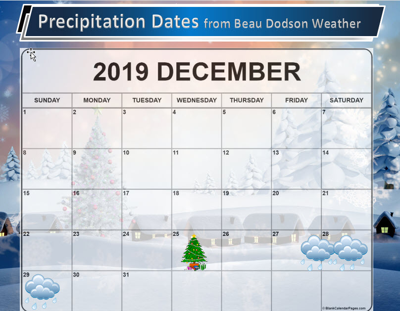
Click to enlarge these graphics.
![]()
![]()
Graphic-cast
Click here if you would like to return to the top of the page.
Illinois
During active weather check my handwritten forecast towards the top of the page.

.
Kentucky
During active weather check my handwritten forecast towards the top of the page.


.
Tennessee
During active weather check my handwritten forecast towards the top of the page.


.
Today through December 26th: No severe thunderstorms. I am monitoring Friday night into Saturday night for the chance of thunderstorms.
.
Today’s outlook (below).
Light green is where thunderstorms may occur but should be below severe levels.
Dark green is a level one risk. Yellow is a level two risk. Orange is a level three (enhanced) risk. Red is a level four (moderate) risk. Pink is a level five (high) risk.
One is the lowest risk. Five is the highest risk.
A severe storm is one that produces 58 mph wind or higher, quarter size hail, and/or a tornado.

The black outline is our local area.

.
Tomorrow’s severe weather outlook.


.

.
24-hour precipitation outlook.
.

.
48-hour precipitation outlook.
.
.
Days one through seven added together. Seven-day rainfall totals.


.
- A nice few days ahead with warm temperatures.
- Rain chances return Friday night into Saturday night. Peak rain chances will likely be on Saturday afternoon and night.
.
![]()
..
Advice:
Monitor Friday night into Saturday night for the chance of thunderstorms.
.
Weather Forecast Analysis
Calm weather has settled in. No weather concerns over the coming days.
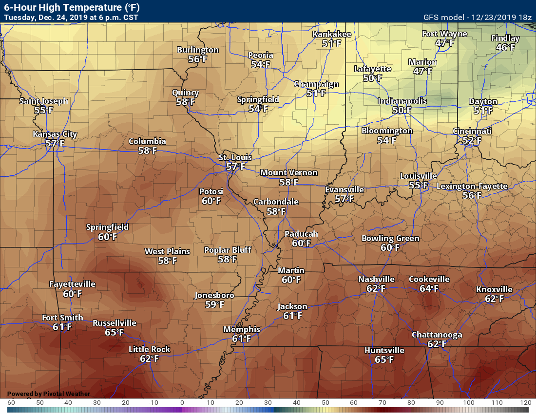
Check out these temperatures. Impressive.
Tuesday
Wednesday
Thursday
Friday
Saturday
.
SHORT and LONG RANGE SNOW OUTLOOK:
I am currently not tracking any winter storms for our local area.
.
 .
.
Click here if you would like to return to the top of the page.
Again, as a reminder, these are models. They are never 100% accurate. Take the general idea from them.
What should I take from these?
- The general idea and not specifics. Models usually do well with the generalities.
- The time-stamp is located in the upper left corner.
.
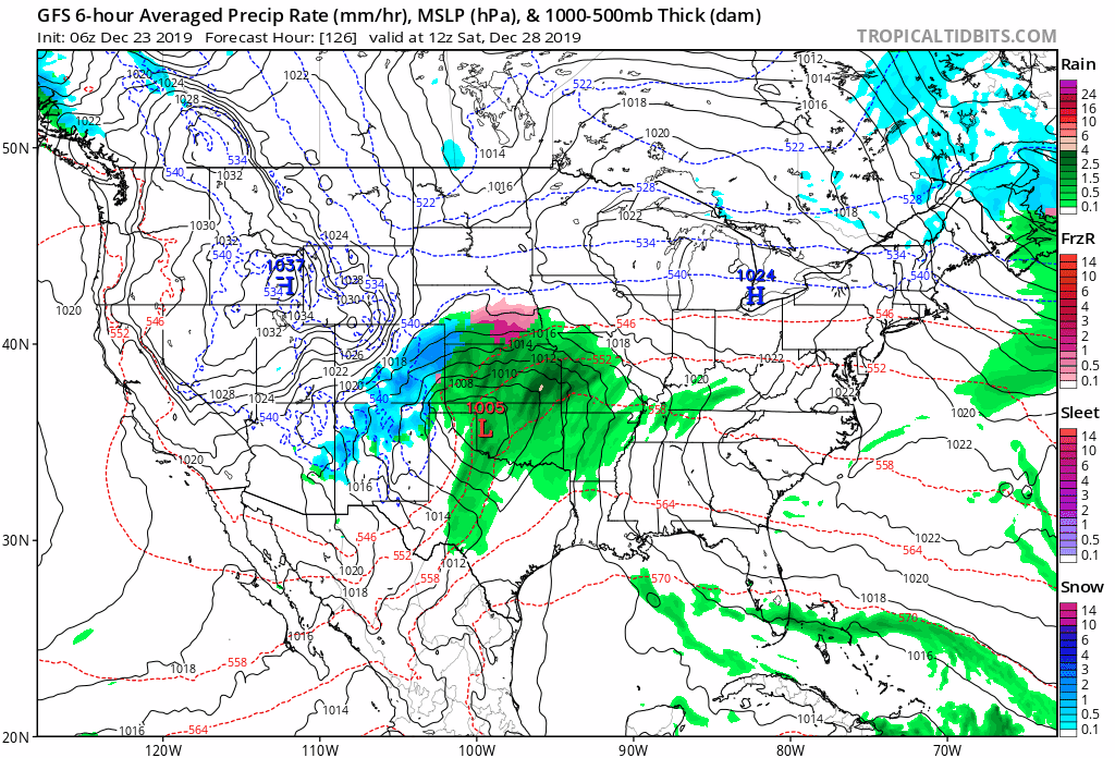
Here is the weekend system as shown on the GFS model guidance.
Click to enlarge.
The track of the low will be key to where strong to severe thunderstorms will occur. I can not rule out strong storms locally. Monitor updates.
.

.
Click here if you would like to return to the top of the page.
.
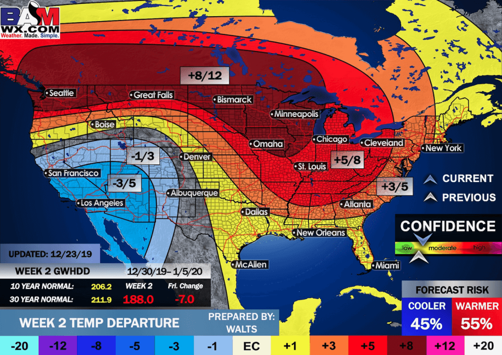
Average high temperatures for this time of the year are around 45 degrees.
Average low temperatures for this time of the year are around 29 degrees.
Average precipitation during this time period ranges from 0.90″ to 1.10″
Yellow and orange colors are above average temperatures. Red is much above average. Light blue and blue are below-average temperatures. Green to purple colors represent much below-average temperatures.
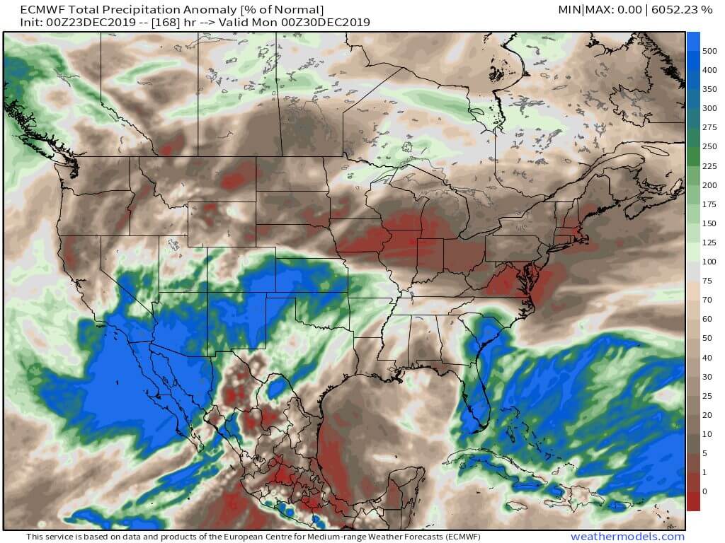
This outlook covers December 23rd through the 29th
Click on the image to expand it.

.
The precipitation forecast is PERCENT OF AVERAGE. Brown is below average. Green is above average. Blue is much above average.
.

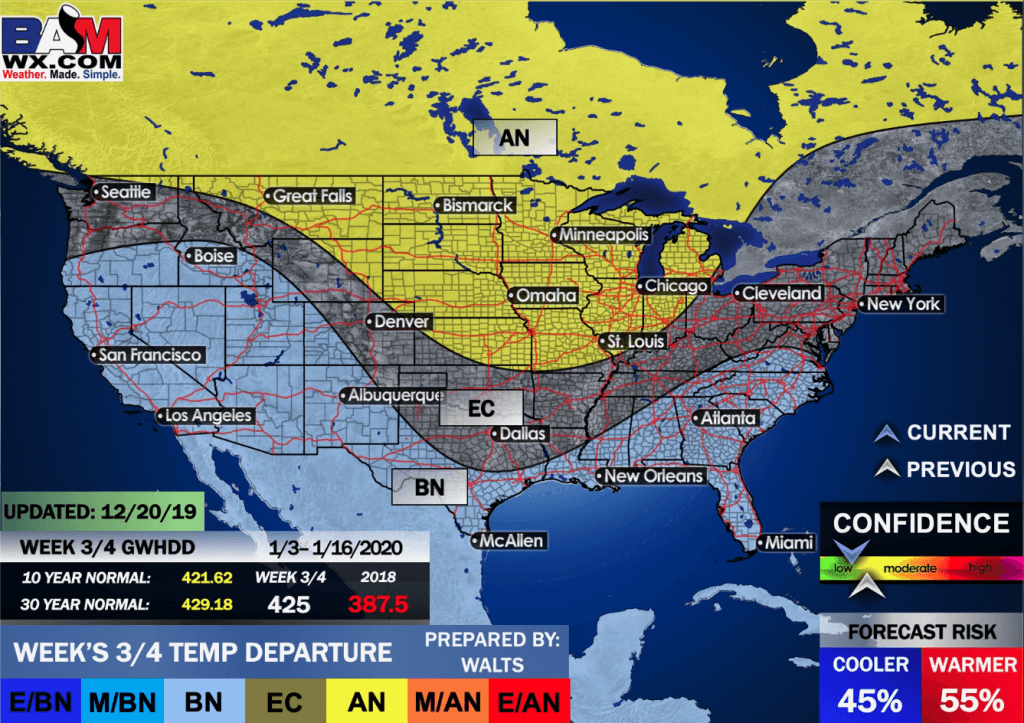
Average low temperatures for this time of the year are around 25 degrees
Average precipitation during this time period ranges from 1.00″ to 1.10″
.
This outlook covers December 30th through January 5th
Click on the image to expand it.
.
The precipitation forecast is PERCENT OF AVERAGE. For example, if your average rainfall is 1.00″ and the graphic shows 25%, then that would mean 0.25″ of rain is anticipated.
.
.

EC = Equal chances of above or below average
BN= Below average
M/BN = Much below average
AN = Above average
M/AN = Much above average
E/AN = Extremely above average
Average low temperatures for this time of the year are around 24 degrees
Average precipitation during this time period ranges from 1.90″ to 2.20″
This outlook covers January 3rd through January 16th
Click on the image to expand it.
.
.
Precipitation outlook
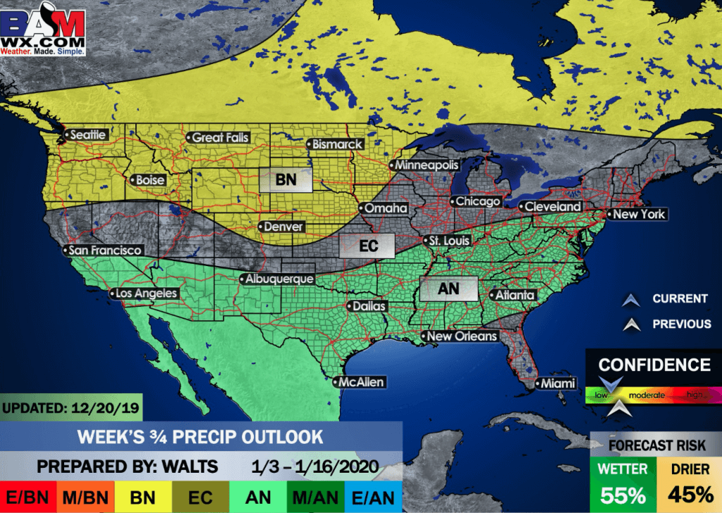
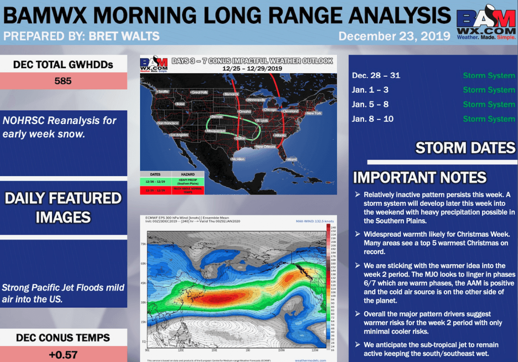
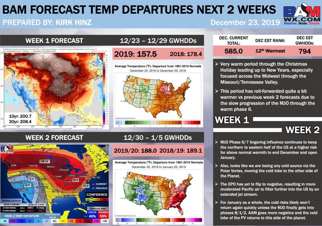
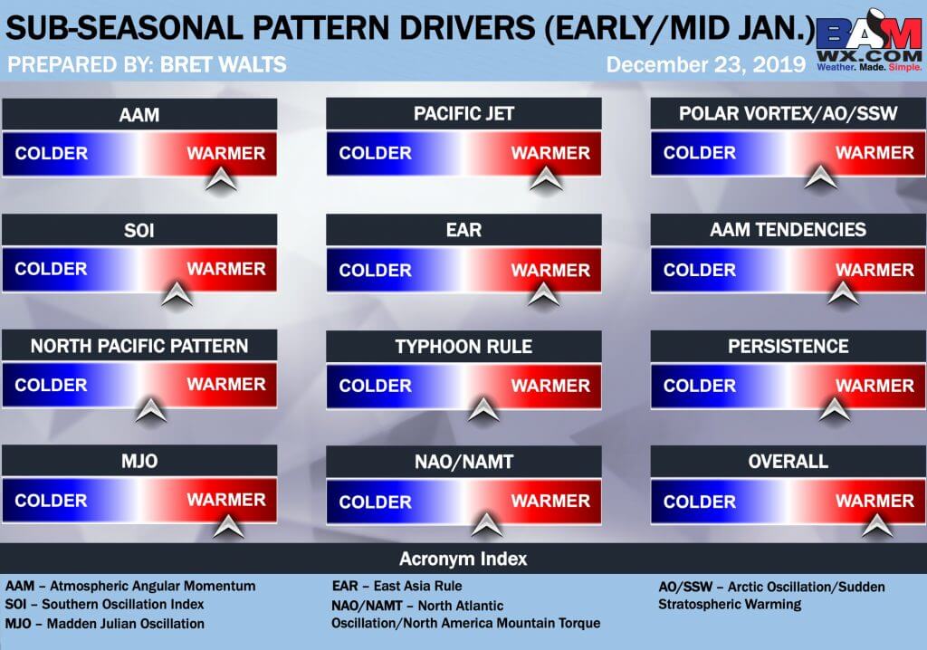
LONG RANGE DISCUSSION
Key Points: This was written by the BAMwx team. I don’t edit it.
Click to enlarge all of the images below
These graphics are updated Monday through Friday between 8:30 AM and 9:30 AM.
NOTE: These may not be updated on Saturday and Sunday.
.


![]()

Great news! The videos are now found in your Weathertalk app and on the WeatherTalk website.
These are bonus videos for subscribers.
The app is for subscribers. Subscribe at www.weathertalk.com/welcome then go to your app store and search for WeatherTalk
Subscribers, PLEASE USE THE APP. ATT and Verizon are not reliable during severe weather. They are delaying text messages.
The app is under WeatherTalk in the app store.

Apple users click here

Android users click here
.

Radar Link: Interactive local city-view radars & regional radars.
You will find clickable warning and advisory buttons on the local city-view radars.
If the radar is not updating then try another one. If a radar does not appear to be refreshing then hit Ctrl F5. You may also try restarting your browser.
Not working? Email me at beaudodson@usawx.com
National map of weather watches and warnings. Click here.
Storm Prediction Center. Click here.
Weather Prediction Center. Click here.
.

Live lightning data: Click here.
.

Interactive GOES R satellite. Track clouds. Click here.
GOES 16 slider tool. Click here.
College of Dupage satellites. Click here
.

Here are the latest local river stage forecast numbers Click Here.
Here are the latest lake stage forecast numbers for Kentucky Lake and Lake Barkley Click Here.
.
.
Find Beau on Facebook! Click the banner.

.
Find Beau on Twitter! Share your weather photos! @beaudodson


Click here if you would like to return to the top of the page.
Did you know that a portion of your monthly subscription helps support local charity projects? Not a subscriber? Becoming one at www.weathertalk.com
You can learn more about those projects by visiting the Shadow Angel Foundation website and the Beau Dodson News website.
