
WeatherTalk monthly operating costs can top $2000.00. Your $5 subscription helps pay for those costs. I work for you.
The $5 will allow you to register up to seven phones!
For $5 a month you can receive the following. You may choose to receive these via your WeatherTalk app or regular text messaging.
Severe weather app/text alerts from my keyboard to your app/cell phone. These are hand typed messages from me to you. During tornado outbreaks, you will receive numerous app/text messages telling you exactly where the tornado is located.
- Daily forecast app/texts from my computer to your app/cell phone.
- Social media links sent directly to your app/cell phone. When I update the blog, videos, or Facebook you will receive the link.
- AWARE emails. These emails keep you well ahead of the storm. They give you several days of lead time before significant weather events.
- Direct access to Beau via text and email. Your very own personal meteorologist. I work for you!
- Missouri and Ohio Valley centered video updates
- Long-range weather videos
- Week one, two, three and four temperature and precipitation outlooks.
Monthly outlooks. - Your subscription also will help support several local charities.
Would you like to subscribe? Subscribe at www.beaudodsonweather.com
Typical progression on a severe weather day for subscribers.


I encourage subscribers to use the app vs regular text messaging. We have found text messaging to be delayed during severe weather. The app typically will receive the messages instantly. I recommend people have three to four methods of receiving their severe weather information.
Remember, my app and text alerts are hand typed and not computer generated. You are being given my personal attention during significant weather events.

WWW.WEATHERTALK.COM subscribers, here is my day to day schedule for your weather products.
These are bonus videos and maps for subscribers. I bring these to you from the BAMwx team. I pay them to help with videos.
The Ohio and Missouri Valley videos cover most of our area. They do not have a specific Tennessee Valley forecast but may add one in the future.
The long-range video is technical. Over time, you can learn a lot about meteorology from the long range video. Just keep in mind, it is a bit more technical.


Subscribe at www.weathertalk.com
![]()

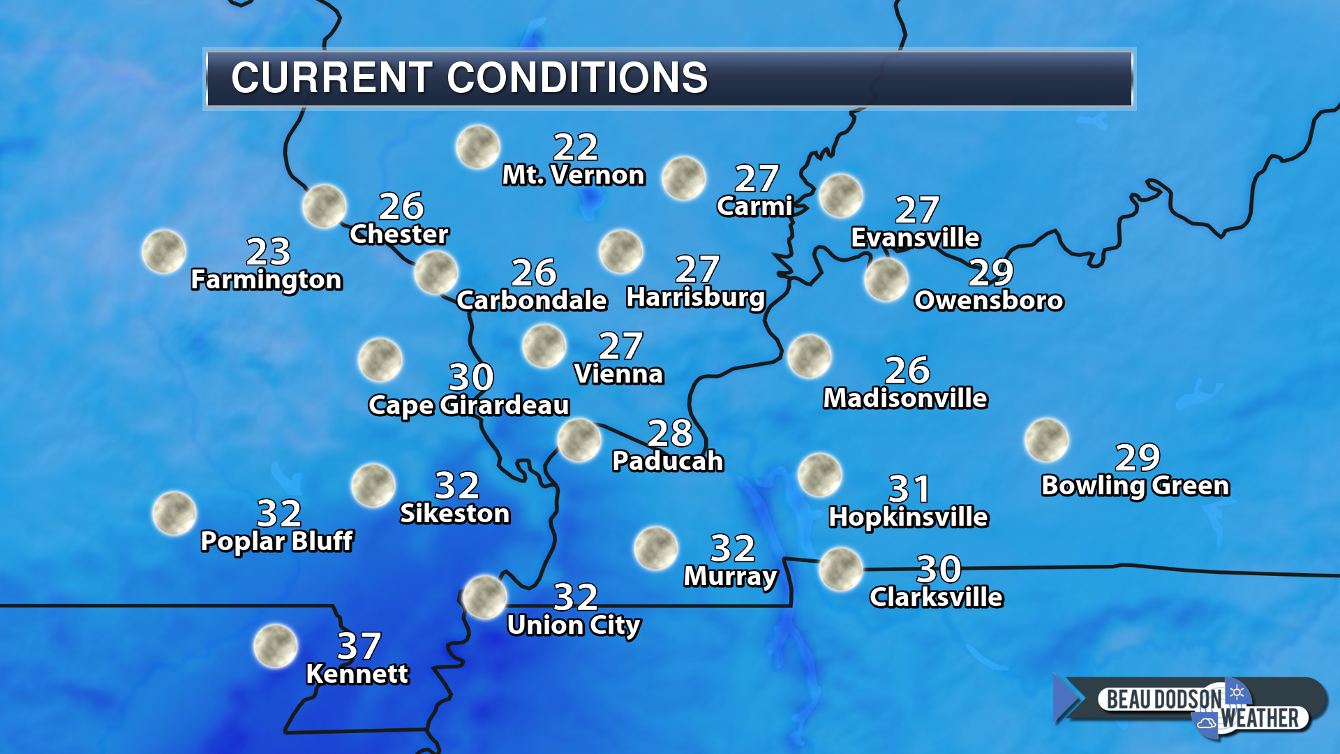
December 19, 2018
Wednesday forecast: Increasing clouds through the day. A slight chance of a rain shower after 4 PM
My confidence in the forecast verifying: Medium (40% confidence in the forecast)
Temperature range: MO ~ 54 to 58 IL ~54 to 56 KY ~ 54 to 58 TN ~ 54 to 58
Wind chill (feels like) temperature forecast: N/A
What is the chance/probability of precipitation? MO ~ 20% IL ~ 10% KY ~ 10% TN ~ 20%
Coverage of precipitation: None AM hours. None to isolated PM hours. (MO)
Is flooding anticipated? No
Is accumulating snow or ice anticipated? No
Is non-accumulating snow or ice anticipated? No
Are icy road conditions anticipated? No
Wind direction and speed: South and southwest at 5 to 10 mph
What impacts are anticipated from the weather? Most likely none. A small chance of light late afternoon showers over southeast Missouri.
Is severe weather expected? No
The NWS officially defines severe weather as 58 mph wind or great, 1″ hail or larger, and/or tornadoes
Will lightning be possible? No
Should I cancel my outdoor plans? No
Will the weather impact my outdoor plans? Most of the day will be dry. Isolate late PM shower over southeast Missouri.
UV Index: 3 to 4 Medium
Sunrise: 7:05 AM
Rain totals of 0.15″ to 0.30″ will be common with this event. I lowered them a bit.
There will be pockets greater than 0.30″ over Kentucky and Tennessee. All in all, a light rain event.
Wednesday Night Forecast Details:
Forecast: Cloudy. Rain showers developing. Greatest coverage late. Patchy fog. Cool.
My confidence in the forecast verifying: High (70% confidence in the forecast)
Temperature range: MO ~ 42 to 45 IL ~ 42 to 46 KY ~ 43 to 46 TN ~ 43 to 46
Wind chill (feels like) temperature forecast: 35 to 45
What is the chance/probability of precipitation? MO ~ 60% IL ~ 50% KY ~ 50% TN ~ 50%
Coverage of precipitation: Scattered to perhaps numerous
Is flooding anticipated? No
Is accumulating snow or ice anticipated? No
Is non-accumulating snow or ice anticipated? No
Are icy road conditions anticipated? No
Wind direction and speed: Southw and southwest at 10 to 20 mph
What impacts are anticipated from the weather? Wet roadways.
Is severe weather expected? No
The NWS officially defines severe weather as 58 mph wind or great, 1″ hail or larger, and/or tornadoes
Will lightning be possible? Most likely no
Should I cancel my outdoor plans? I would not cancel evening plans. I would monitor updates and radars. The exact timing of the rain moving into the region is still a bit of a question.
Will the weather impact my outdoor plans? Rain could cause issues for outdoor activities, especially as we move later into the night.
Sunset: 4:40 PM
Moonrise: 2:35 PM Waxing Crescent
Moonset: 3:26 AM
December 20, 2018
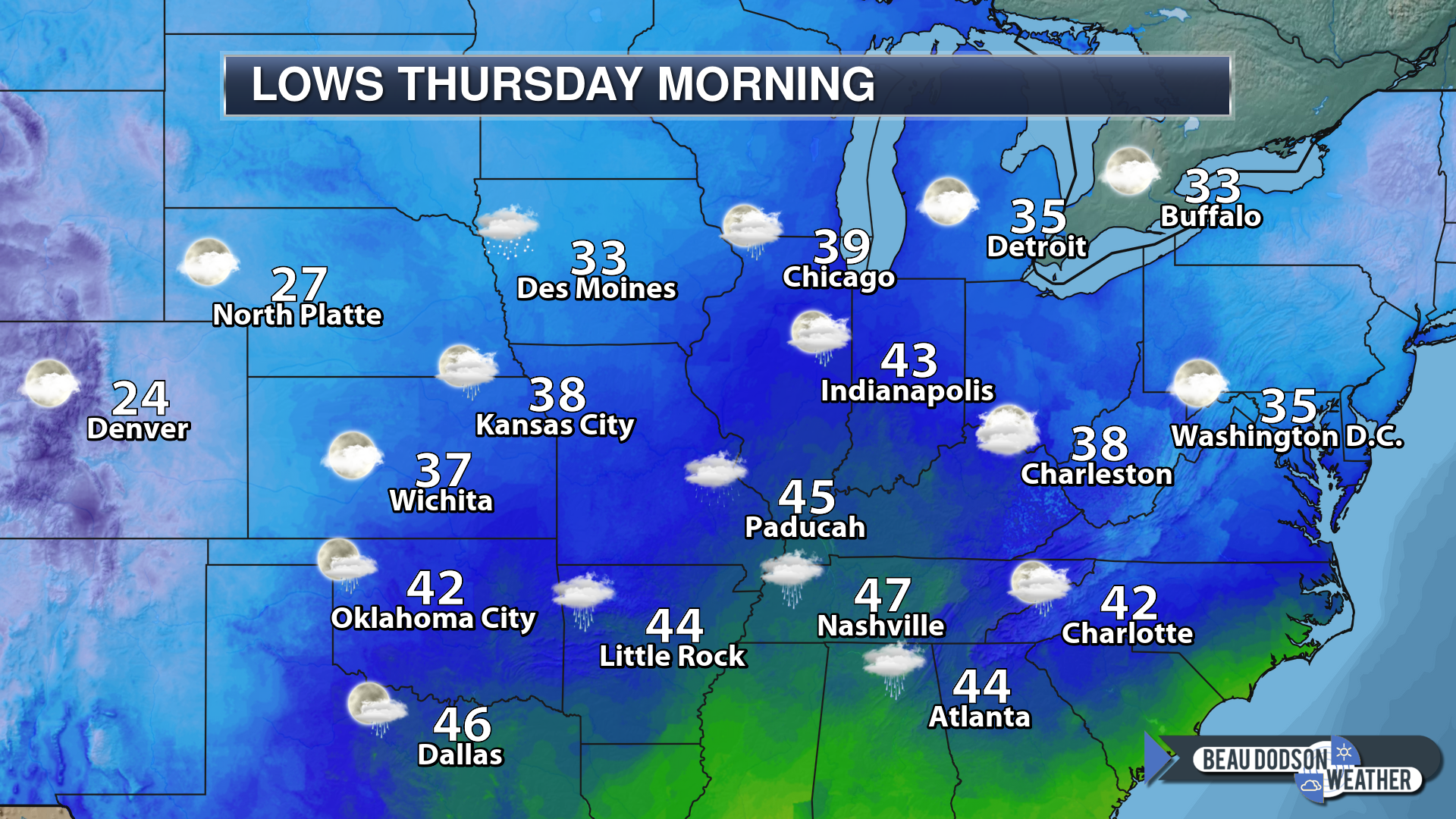
Thursday forecast: Rain showers. Drizzle. Patchy fog possible.
My confidence in the forecast verifying: High (70% confidence in the forecast)
Temperature range: MO ~ 48 to 52 IL ~48 to 52 KY ~ 48 to 52 TN ~ 50 to 54
Wind chill (feels like) temperature forecast: 40 to 45
What is the chance/probability of precipitation? MO ~ 60% IL ~ 60% KY ~ 60% TN ~ 60%
Coverage of precipitation: Numerous
Is flooding anticipated? No
Is accumulating snow or ice anticipated? No
Is non-accumulating snow or ice anticipated? No
Are icy road conditions anticipated? No
Wind direction and speed: Winds variable early in the day becoming mainly north during the afternoon. Wind speed of 7 to 14 mph with gusts to 25 mph (mainly PM hours for gustier winds)
What impacts are anticipated from the weather? Wet roadways
Is severe weather expected? No
The NWS officially defines severe weather as 58 mph wind or great, 1″ hail or larger, and/or tornadoes
Will lightning be possible? No
Should I cancel my outdoor plans? Have a plan B
Will the weather impact my outdoor plans? Wet conditions will interfere with outdoor activities. Gusty winds will also be an issue.
UV Index: 1 to 2 Low
Sunrise: 7:05 AM
Thursday Night Forecast Details:
Forecast: A few remaining rain showers. Windy. Turning colder. Rain may end with a rain/snow mix with little or no accumulation.
My confidence in the forecast verifying: Medium (60% confidence in the forecast)
Temperature range: MO ~ 34 to 38 IL ~ 34 to 36 KY ~ 35 to 36 TN ~ 36 to 40
Wind chill (feels like) temperature forecast: 20 to 30
What is the chance/probability of precipitation? MO ~ 60% IL ~ 60% KY ~ 60% TN ~ 60%
Coverage of precipitation: Perhaps numerous becoming widely scattered. Diminishing coverage as the system pulls away from the region.
Is flooding anticipated? No
Is accumulating snow or ice anticipated? Rain may end with a rain/snow mix with little or no accumulation.
Is non-accumulating snow or ice anticipated? Rain may end with a rain/snow mix with little or no accumulation.
Are icy road conditions anticipated? Unlikely
Wind direction and speed: Northwest 15 to 30 mph with gusts to 40 mph
What impacts are anticipated from the weather? Wet roads and gusty wind conditions.
Is severe weather expected? No
The NWS officially defines severe weather as 58 mph wind or great, 1″ hail or larger, and/or tornadoes
Will lightning be possible? No
Should I cancel my outdoor plans? Have a plan B
Will the weather impact my outdoor plans? Yes. Damp conditions combined with strong winds will make it feel uncomfortable outside.
Sunset: 4:40 PM
Moonrise: 3:15 PM Waxing Crescent
Moonset: 4:32 AM
December 21, 2018
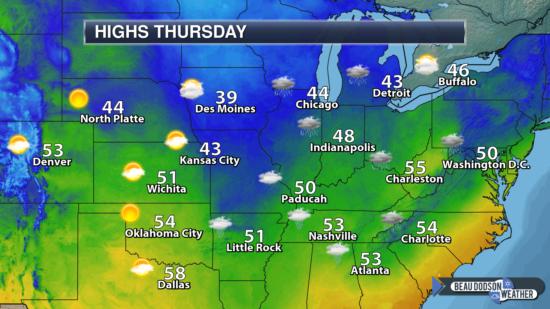
Friday forecast: Windy. Rain ending from west to east. The rain may end as a wintry mix or snow.
My confidence in the forecast verifying: Medium (40% confidence in the forecast)
Temperature range: MO ~ 38 to 44 IL ~ 38 to 44 KY ~ 38 to 44 TN ~ 38 to 44
Wind chill (feels like) temperature forecast: 15 to 30
What is the chance/probability of precipitation? ENDING west to east MO ~ 30% IL ~ 40% KY ~ 50% TN ~ 40%
Coverage of precipitation: Ending west to east during the AM hours
Is flooding anticipated? No
Is accumulating snow or ice anticipated? The rain may end as snow. Little or no accumulation.
Is non-accumulating snow or ice anticipated? The rain may end as snow. Little or no accumulation.
Are icy road conditions anticipated? The rain may end as snow. Little or no accumulation.
Wind direction and speed: Northwest at 15 to 30 mph with higher gusts.
What impacts are anticipated from the weather? Damp. Cold wind chill values. Wet roadways.
Is severe weather expected? No
The NWS officially defines severe weather as 58 mph wind or great, 1″ hail or larger, and/or tornadoes
Will lightning be possible? No
Should I cancel my outdoor plans? Have a plan B before 10 AM and monitor updates.
Will the weather impact my outdoor plans? Yes. Cold wind chill values combined with damp conditions will make it unpleasant.
UV Index: 3 Medium
Sunrise: 7:06 AM
Friday Night Forecast Details:
Forecast: Mostly clear and cold.
My confidence in the forecast verifying: High (70% confidence in the forecast)
Temperature range: MO ~ 25 to 30 IL ~ 25 to 30 KY ~ 26 to 30 TN ~ 28 to 32
Wind chill (feels like) temperature forecast: 18 to 24
What is the chance/probability of precipitation? MO ~ 0% IL ~ 0% KY ~ 0% TN ~ 0%
Coverage of precipitation: None
Is flooding anticipated? No
Is accumulating snow or ice anticipated? No
Is non-accumulating snow or ice anticipated? No
Are icy road conditions anticipated? No
Wind direction and speed: West at 6 to 12 mph with gusts to 20 mph
What impacts are anticipated from the weather? None
Is severe weather expected? No
The NWS officially defines severe weather as 58 mph wind or great, 1″ hail or larger, and/or tornadoes
Will lightning be possible? No
Should I cancel my outdoor plans? No
Will the weather impact my outdoor plans? Other than cold temperatures, no.
Sunset: 4:41 PM
Moonrise: 4:03 PM Waxing Crescent
Moonset: 5:42 AM
December 22, 2018
Saturday forecast: Mostly sunny. Cool.
My confidence in the forecast verifying: High (70% confidence in the forecast)
Temperature range: MO ~ 48 to 52 IL ~48 to 52 KY ~ 48 to 52 TN ~ 48 to 52
Wind chill (feels like) temperature forecast: 45 to 50
What is the chance/probability of precipitation? MO ~ 0% IL ~ 0% KY ~ 0% TN ~ 0%
Coverage of precipitation: None
Is flooding anticipated? No
Is accumulating snow or ice anticipated? No
Is non-accumulating snow or ice anticipated? No
Are icy road conditions anticipated? No
Wind direction and speed: West and northwest at 5 to 10 mph. Wind becoming southwest.
What impacts are anticipated from the weather? None
Is severe weather expected? No
The NWS officially defines severe weather as 58 mph wind or great, 1″ hail or larger, and/or tornadoes
Will lightning be possible? No
Should I cancel my outdoor plans? No
Will the weather impact my outdoor plans? None
UV Index: 2 Low
Sunrise: 7:06 AM
Saturday Night Forecast Details:
Forecast: Mostly clear and chilly. Patchy fog possible.
My confidence in the forecast verifying: Medium (60% confidence in the forecast)
Temperature range: MO ~ 26 to 32 IL ~ 26 to 32 KY ~ 28 to 32 TN ~ 30 to 34
Wind chill (feels like) temperature forecast:
What is the chance/probability of precipitation? MO ~ 0% IL ~ 0% KY ~ 0% TN ~ 0%
Coverage of precipitation: None
Is flooding anticipated? No
Is accumulating snow or ice anticipated? No
Is non-accumulating snow or ice anticipated? No
Are icy road conditions anticipated? No
Wind direction and speed: Southwest and west at 5 to 10 mph. Wind becoming northwest.
What impacts are anticipated from the weather? None
Is severe weather expected? No
The NWS officially defines severe weather as 58 mph wind or great, 1″ hail or larger, and/or tornadoes
Will lightning be possible? No
Should I cancel my outdoor plans? No
Will the weather impact my outdoor plans? None
Sunset: 4:41 PM
Moonrise: 4:57 PM Full
Moonset: 6:48 AM
December 23, 2018
Sunday forecast: Partly cloudy.
My confidence in the forecast verifying: Low (30% confidence in the forecast)
Temperature range: MO ~ 44 to 46 IL ~44 to 46 KY ~ 44 to 48 TN ~ 46 to 48
Wind chill (feels like) temperature forecast:
What is the chance/probability of precipitation? MO ~ 10% IL ~ 10% KY ~ 10% TN ~ 20%
Coverage of precipitation: Most likely none, but monitor updates
Is flooding anticipated? No
Is accumulating snow or ice anticipated? No
Is non-accumulating snow or ice anticipated? No
Are icy road conditions anticipated? No
Wind direction and speed: North and northwest at 5 to 10 mph
What impacts are anticipated from the weather? Most likely none.
Is severe weather expected? No
The NWS officially defines severe weather as 58 mph wind or great, 1″ hail or larger, and/or tornadoes
Will lightning be possible? No
Should I cancel my outdoor plans? No
Will the weather impact my outdoor plans? None
UV Index: 2 Low
Sunrise: 7:07 AM
Sunday Night Forecast Details:
Forecast: Partly cloudy. Light rain or snow showers possible. Little or no accumulation.
My confidence in the forecast verifying: Low (30% confidence in the forecast)
Temperature range: MO ~ 28 to 34 IL ~ 28 to 34 KY ~ 32 to 36 TN ~ 32 to 36
Wind chill (feels like) temperature forecast: 25 to 30
What is the chance/probability of precipitation? MO ~ 30% IL ~ 30% KY ~ 30% TN ~ 30%
Coverage of precipitation: Scattered
Is flooding anticipated? No
Is accumulating snow or ice anticipated? Most likely no. Monitor updates.
Is non-accumulating snow or ice anticipated? Perhaps a few snowflakes.
Are icy road conditions anticipated? Unlikely, but monitor updates.
Wind direction and speed: Variable at 5 to 10 mph
What impacts are anticipated from the weather? Perhaps some wet roadways. Monitor updates.
Is severe weather expected? No
The NWS officially defines severe weather as 58 mph wind or great, 1″ hail or larger, and/or tornadoes
Will lightning be possible? No
Should I cancel my outdoor plans? No
Will the weather impact my outdoor plans? Late night rain or snow showers will cause damp conditions. Monitor updates in case precipitation is heavier than anticipated. Some icy bridges could occur if that were the case.
Sunset: 4:42 PM
Moonrise: 6:00 PM Waning Gibbous
Moonset: 7:53 AM
December 24, 2018
Christmas Eve
Monday forecast: Morning clouds becoming partly cloudy. A few rain or snow showers during the morning.
My confidence in the forecast verifying: Medium (40% confidence in the forecast)
Temperature range: MO ~ 44 to 48 IL ~44 to 48 KY ~ 46 to 48 TN ~ 46 to 48
Wind chill (feels like) temperature forecast: 40 to 45
What is the chance/probability of precipitation? MO ~ 30% IL ~ 30% KY ~ 30% TN ~ 30%
Coverage of precipitation: Perhaps scattered
Is flooding anticipated? No
Is accumulating snow or ice anticipated? Most likely no. Monitor updates.
Is non-accumulating snow or ice anticipated? Perhaps
Are icy road conditions anticipated? Most likely no but monitor updated forecasts.
Wind direction and speed: East and southeast at 5 to 10 mph
What impacts are anticipated from the weather? Wet roadways. I will be monitoring precipitation chances. A few icy roads would be possible if snow developed.
Is severe weather expected? No
The NWS officially defines severe weather as 58 mph wind or great, 1″ hail or larger, and/or tornadoes
Will lightning be possible? No
Should I cancel my outdoor plans? No, but monitor updates
Will the weather impact my outdoor plans? Monitor updates
UV Index: 2 Low
Sunrise: 7:07 AM
Monday Night Forecast Details:
Christmas Eve
Forecast: Partly cloudy. A slight chance of a shower or snow shower.
My confidence in the forecast verifying: Low (30% confidence in the forecast)
Temperature range: MO ~ 30 to 35 IL ~ 30 to 35 KY ~ 30 to 35 TN ~ 30 to 35
Wind chill (feels like) temperature forecast: 25 to 30
What is the chance/probability of precipitation? MO ~ 20% IL ~ 20% KY ~ 20% TN ~ 20%
Coverage of precipitation: Perhaps widely scattered. Low confidence.
Is flooding anticipated? No
Is accumulating snow or ice anticipated? Most likely no, but monitor updates
Is non-accumulating snow or ice anticipated? Possible
Are icy road conditions anticipated? No
Wind direction and speed: Southeast at 7 to 14 mph
What impacts are anticipated from the weather? A few wet roadways. Monitor updates.
Is severe weather expected? No
The NWS officially defines severe weather as 58 mph wind or great, 1″ hail or larger, and/or tornadoes
Will lightning be possible? No
Should I cancel my outdoor plans? No
Will the weather impact my outdoor plans? Most likely no
Sunset: 4:42 PM
Moonrise: 7:08 PM Waning Gibbous
Moonset: 8:52 AM
December 25, 2018
Christmas
Tuesday forecast: Partly sunny. A slight chance of a shower or snow shower.
My confidence in the forecast verifying: Low (30% confidence in the forecast)
Temperature range: MO ~ 46 to 52 IL ~46 to 52 KY ~ 48 to 54 TN ~ 50 to 54
Wind chill (feels like) temperature forecast:
What is the chance/probability of precipitation? MO ~ 20% IL ~ 20% KY ~ 20% TN ~ 20%
Coverage of precipitation: None to isolated
Is flooding anticipated? No
Is accumulating snow or ice anticipated? Most likely no, but monitor updates
Is non-accumulating snow or ice anticipated? Perhaps during the AM hours.
Are icy road conditions anticipated? No
Wind direction and speed: Southwest to west at 7 to 14 mph
What impacts are anticipated from the weather? Perhaps a few wet roadways.
Is severe weather expected? No
The NWS officially defines severe weather as 58 mph wind or great, 1″ hail or larger, and/or tornadoes
Will lightning be possible? No
Should I cancel my outdoor plans? No
Will the weather impact my outdoor plans? Most likely no, but monitor updates
UV Index: 2 Low
Sunrise: 7:07 AM
Tuesday Night Forecast Details:
Christmas Night
Forecast: Partly cloudy.
My confidence in the forecast verifying: Medium (60% confidence in the forecast)
Temperature range: MO ~ 35 to 40 IL ~ 35 to 40 KY ~ 35 to 40 TN ~ 35 to 40
Wind chill (feels like) temperature forecast: 30 to 35
What is the chance/probability of precipitation? MO ~ 0% IL ~ 0% KY ~ 0% TN ~ 0%
Coverage of precipitation: None
Is flooding anticipated? No
Is accumulating snow or ice anticipated? No
Is non-accumulating snow or ice anticipated? No
Are icy road conditions anticipated? No
Wind direction and speed: Northwest at 6 to 12 mph
What impacts are anticipated from the weather? None
Is severe weather expected? No
The NWS officially defines severe weather as 58 mph wind or great, 1″ hail or larger, and/or tornadoes
Will lightning be possible? No
Should I cancel my outdoor plans? No
Will the weather impact my outdoor plans? No
Sunset: 4:43 PM
Moonrise: 8:19 PM Waning Gibbous
Moonset: 9:44 AM
December 26, 2018
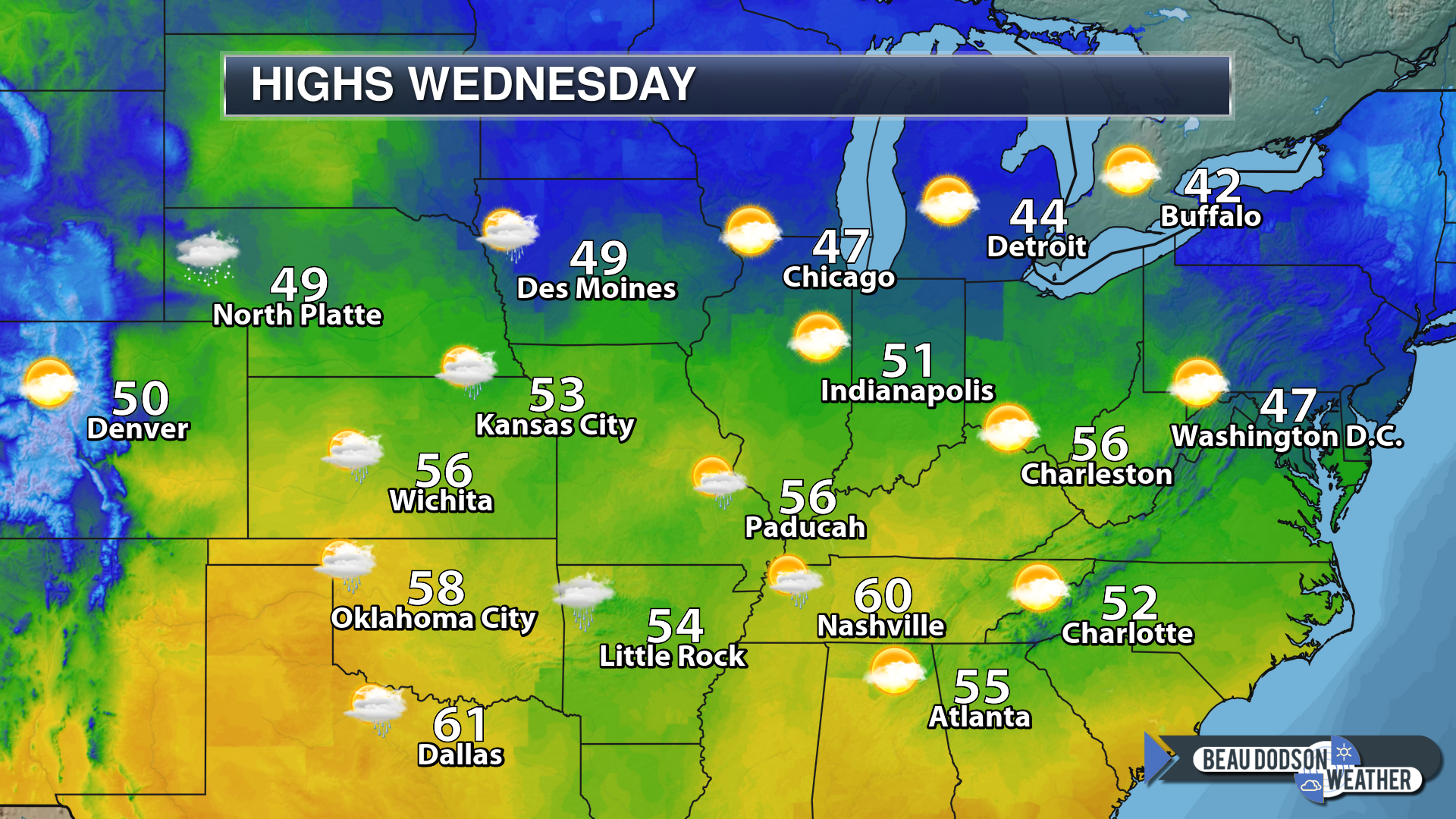
Wednesday Forecast: Partly sunny. Clouds increasing during the PM hours. A slight chance of a shower.
My confidence in the forecast verifying: Low (30% confidence in the forecast)
Temperature range: MO ~ 50 to 55 IL ~ 50 to 55 KY ~ 50 to 55 TN ~ 50 to 55
Wind chill (feels like) temperature forecast:
What is the chance/probability of precipitation? MO ~ 20% IL ~ 20% KY ~ 20% TN ~ 20%
Coverage of precipitation: None to isolated PM hours
Is flooding anticipated? No
Is accumulating snow or ice anticipated? No
Is non-accumulating snow or ice anticipated? No
Are icy road conditions anticipated? No
Wind direction and speed: Southeast at 7 to 14 mph
What impacts are anticipated from the weather? Most likely none.
Is severe weather expected? No
The NWS officially defines severe weather as 58 mph wind or great, 1″ hail or larger, and/or tornadoes
Will lightning be possible? No
Should I cancel my outdoor plans? No
Will the weather impact my outdoor plans? Most likely no
UV Index: 2 Low
Sunrise: 7:08 AM
Wednesday Night Forecast Details:
Forecast: Cloudy. A chance of showers developing late.
My confidence in the forecast verifying: Low (30% confidence in the forecast)
Temperature range: MO ~ 44 to 48 IL ~ 44 to 48 KY ~ 45 to 50 TN ~ 45 to 50
Wind chill (feels like) temperature forecast:
What is the chance/probability of precipitation? MO ~ 30% IL ~ 20% KY ~ 20% TN ~ 20%
Coverage of precipitation: None to scattered
Is flooding anticipated? No
Is accumulating snow or ice anticipated? No
Is non-accumulating snow or ice anticipated? No
Are icy road conditions anticipated? No
Wind direction and speed: South at 6 to 12 mph with gusts to 20 mph
What impacts are anticipated from the weather? Wet roadways.
Is severe weather expected? Most likely no, but monitor updates.
The NWS officially defines severe weather as 58 mph wind or great, 1″ hail or larger, and/or tornadoes
Will lightning be possible? Unlikely
Should I cancel my outdoor plans? Not at this time.
Will the weather impact my outdoor plans? Rain could cause damp conditions. The timing of the rain is still in question. Monitor updates.
Sunset: 4:43 PM
Moonrise: 9:30 PM Waning Gibbous
Moonset: 10:28 AM
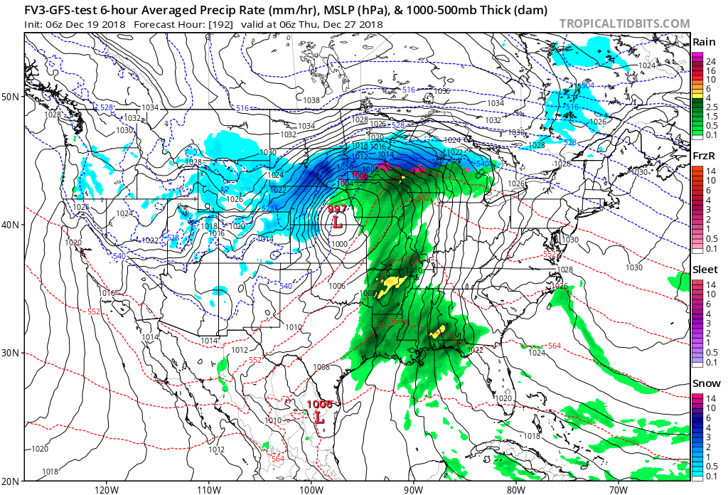
December 27, 2018
Thursday Forecast: Cloudy. A chance of showers. A thunderstorm possible.
My confidence in the forecast verifying: Medium (40% confidence in the forecast)
Temperature range: MO ~ 54 to 58 IL ~ 54 to 58 KY ~ 54 to 58 TN ~ 54 to 58
Wind chill (feels like) temperature forecast:
What is the chance/probability of precipitation? MO ~ 40% IL ~ 40% KY ~ 40% TN ~ 40%
Coverage of precipitation: Scattered
Is flooding anticipated? No
Is accumulating snow or ice anticipated? No
Is non-accumulating snow or ice anticipated? No
Are icy road conditions anticipated? No
Wind direction and speed: South and southwest at 8 to 16 mph
What impacts are anticipated from the weather? Wet roadways. Perhaps lightning. Low confidence in the lightning.
Is severe weather expected? Monitor updates
The NWS officially defines severe weather as 58 mph wind or great, 1″ hail or larger, and/or tornadoes
Will lightning be possible? Yes
Should I cancel my outdoor plans? Monitor updates
Will the weather impact my outdoor plans? Rain could cause wet conditions for outdoor activities. I would suggest monitoring updates. This is still in the long range.
UV Index: 2 Low
Sunrise: 7:08 AM
Thursday Night Forecast Details:
Forecast: Cloudy. A chance of showers. A thunderstorm possible.
My confidence in the forecast verifying: Low (30% confidence in the forecast)
Temperature range: MO ~ 44 to 48 IL ~ 44 to 48 KY ~ 45 to 50 TN ~ 45 to 50
Wind chill (feels like) temperature forecast:
What is the chance/probability of precipitation? MO ~ 40% IL ~ 40% KY ~ 40% TN ~ 40%
Coverage of precipitation: Scattered
Is flooding anticipated? No
Is accumulating snow or ice anticipated? No
Is non-accumulating snow or ice anticipated? No
Are icy road conditions anticipated? No
Wind direction and speed: South at 6 to 12 mph with gusts to 20 mph
What impacts are anticipated from the weather? Wet roadways. Perhaps lightning. Low confidence in the lightning.
Is severe weather expected? Most likely no, but monitor updates.
The NWS officially defines severe weather as 58 mph wind or great, 1″ hail or larger, and/or tornadoes
Will lightning be possible? Perhaps
Should I cancel my outdoor plans? Monitor
Will the weather impact my outdoor plans? Rain could cause damp conditions. Monitor updates.
Sunset: 4:44PM
Moonrise: 10:35 PM Waning Gibbous
Moonset: 11:08 AM
Learn more about the UV index readings. Click here.
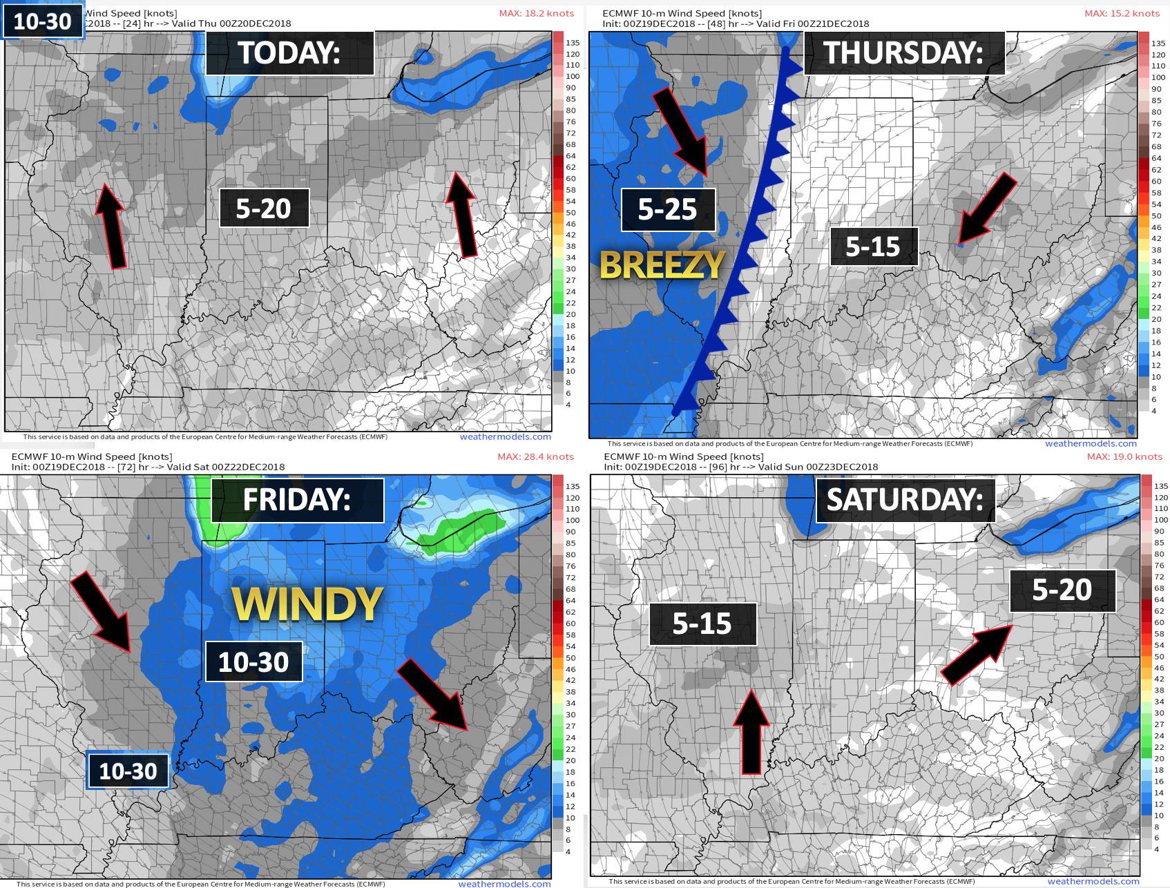
Wind forecast
Click to enlarge
.

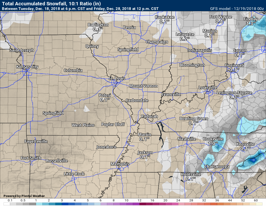
Wednesday: Wintry precipitation is not anticipated.
Thursday: Wintry precipitation is not anticipated. Rain is in the forecast.
Thursday night: The rain may end as snow. Little or no accumulation.
Friday: The rain may end as snow. Little or no accumulation.
Saturday: Wintry precipitation is not anticipated.
Sunday: A few snow showers possible Sunday night/Monday morning. Little or no accumulation if this occurs.
Monday: A small chance of a snow shower Monday night. Little or no accumulation if this occurs.
Tuesday: A small chance of a snow shower Christmas morning.

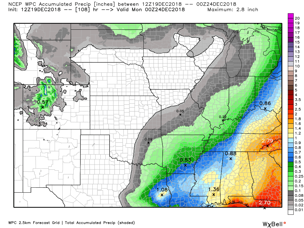
Here is the WPC/NOAA rainfall outlook
Click to enlarge.
The next rain event will arrive Wednesday night into Thursday night.
You can expect a widespread 0.10″ to 0.30″ rain event. Locally higher totals possible across western Kentucky and western Tennessee.
Click to enlarge graphics on the blog.
Did you know that you can find me on Twitter?

Subscribers, do you need a forecast for an outdoor event?


We offer interactive local city live radars and regional radars.
If a radar does not update then try another one. If a radar does not appear to be refreshing then hit Ctrl F5 on your keyboard.
You may also try restarting your browser. The local city view radars also have clickable warnings.
During the winter months, you can track snow and ice by clicking the winterize button on the local city view interactive radars.

Questions? Broken links? Other questions?
You may email me at beaudodson@usawx.com

The National Weather Service defines a severe thunderstorm as one that produces quarter size hail or larger, 58 mph winds or greater, and/or a tornado.
Today through next Tuesday: No severe weather.
Interactive live weather radar page. Choose the city nearest your location. If one of the cities does not work then try a nearby one. Click here.
National map of weather watches and warnings. Click here.
Storm Prediction Center. Click here.
Weather Prediction Center. Click here.

Live lightning data: Click here.

Interactive GOES R satellite. Track clouds. Click here.

Here are the latest local river stage forecast numbers Click Here.
Here are the latest lake stage forecast numbers for Kentucky Lake and Lake Barkley Click Here.

- Increasing clouds today.
- Light rain event tonight into Thursday night. Widespread 0.10″ to 0.30″ with higher totals possible.
- Slight chance of snow showers Sunday and Monday night.
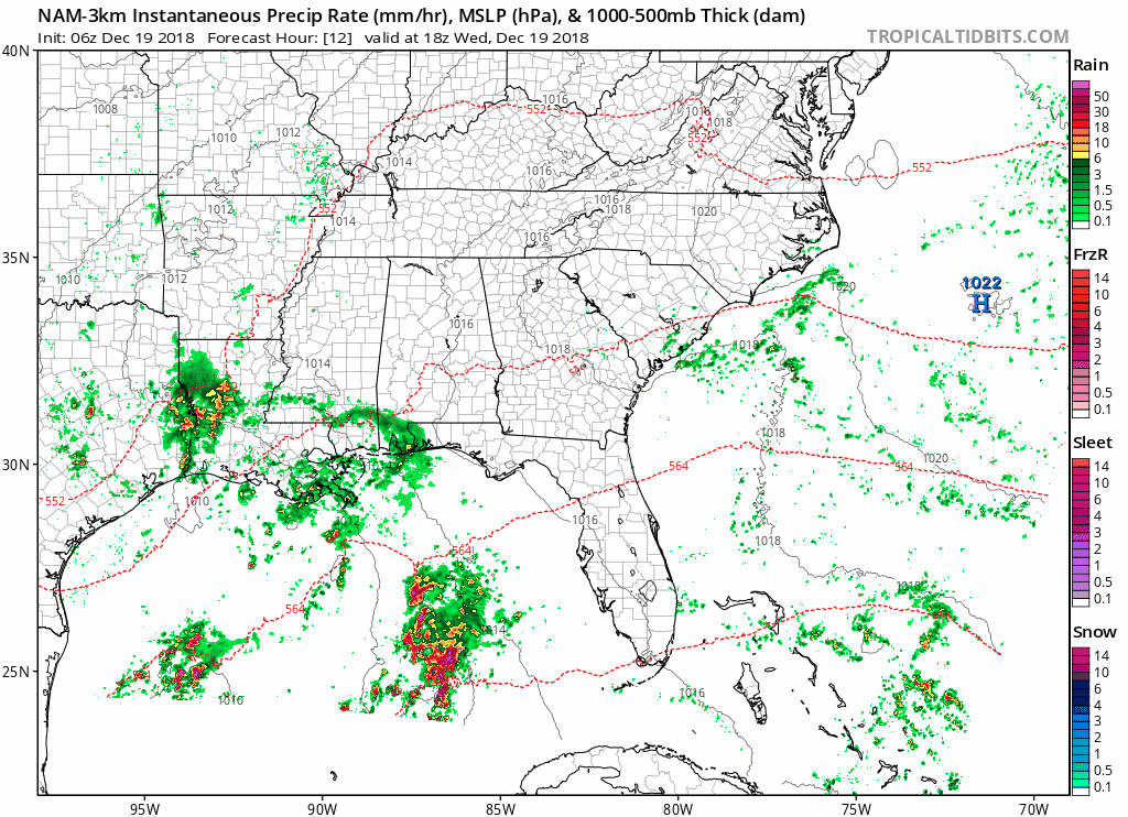
We will have increasing clouds today as a storm system develops in Texas and moves northeast.
You can see the clouds already moving into the region on this mornings satellite imagery.
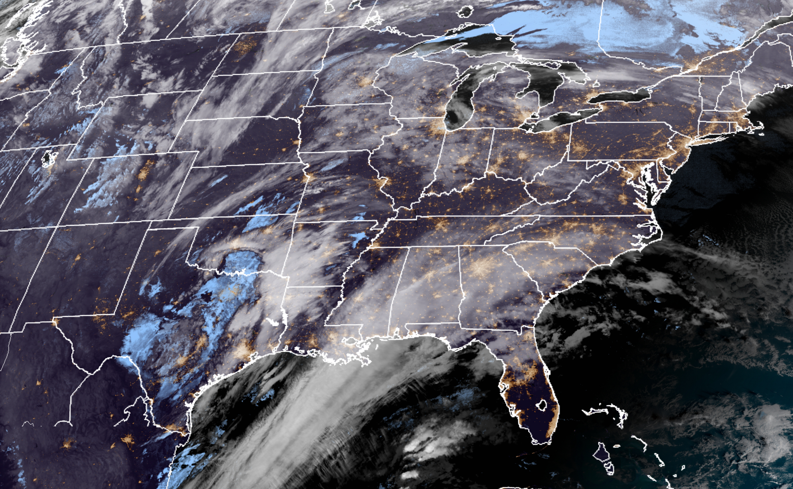
This will be a larger system as it pulls away from our region.
That means we will be in the beginning stages of the system. Widespread light rain and rain showers will develop tonight and linger into early Friday.
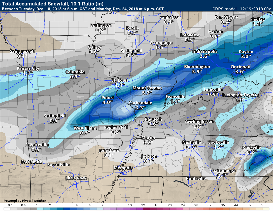
This is not going to be a heavy rain event. You can expect a widespread 0.10″ to 0.30″ event. I did lower totals a bit. There will be some patches of higher totals. The most likely area for this to happen would be the eastern half of western Kentucky and into western Tennessee.
The rain may end as snow late Thursday night and Friday morning. Accumulations, if any would be light.
Some of the models show almost no rain at all. That seems unlikely. Low totals do appear likely.
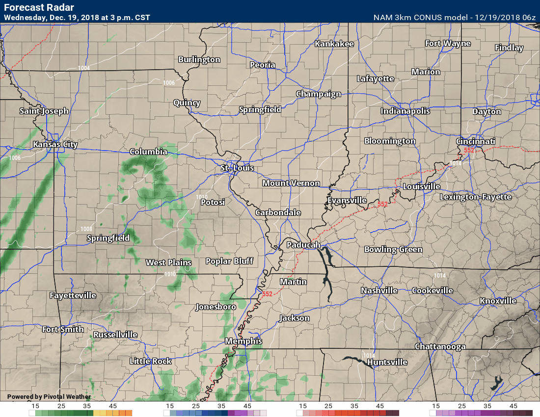
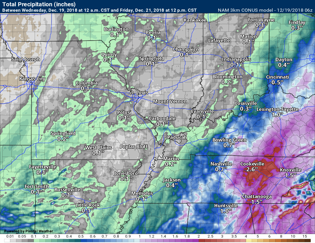
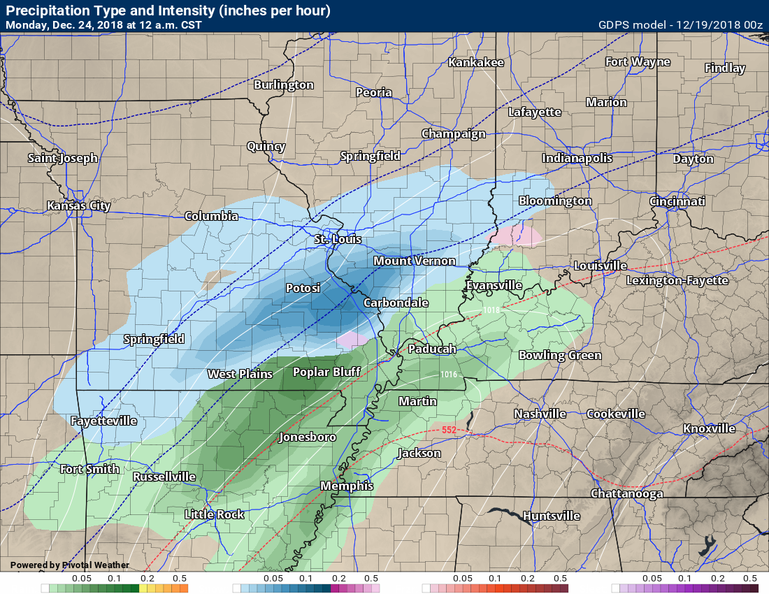
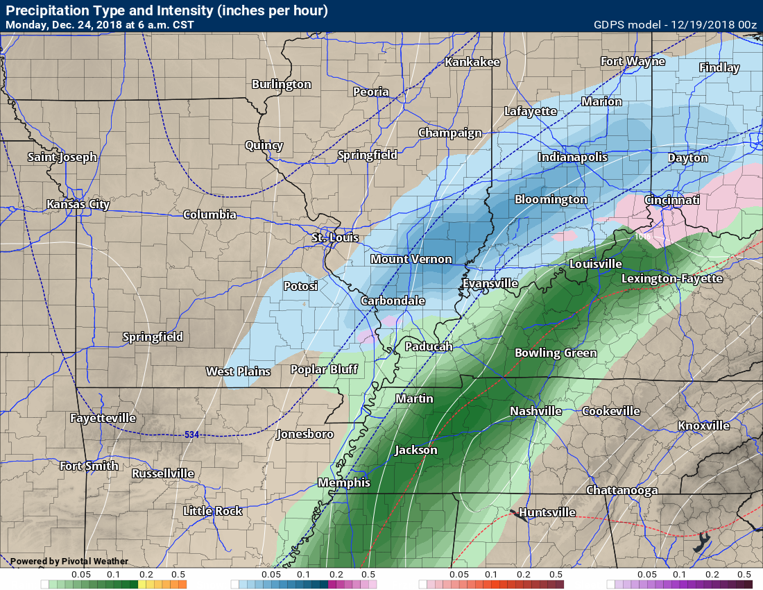
Here is the NAM 3K model guidance future-cast radar animation.
Click to enlarge all the images on the WeatherTalk weather blog.
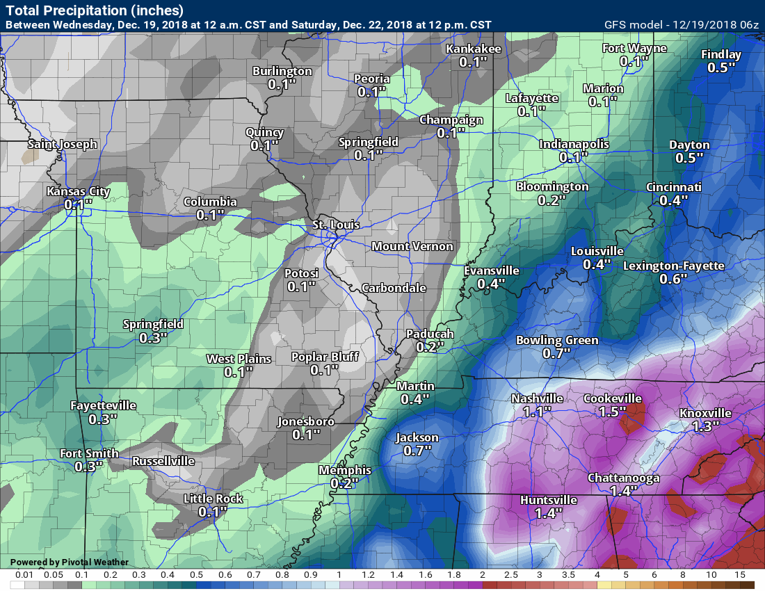
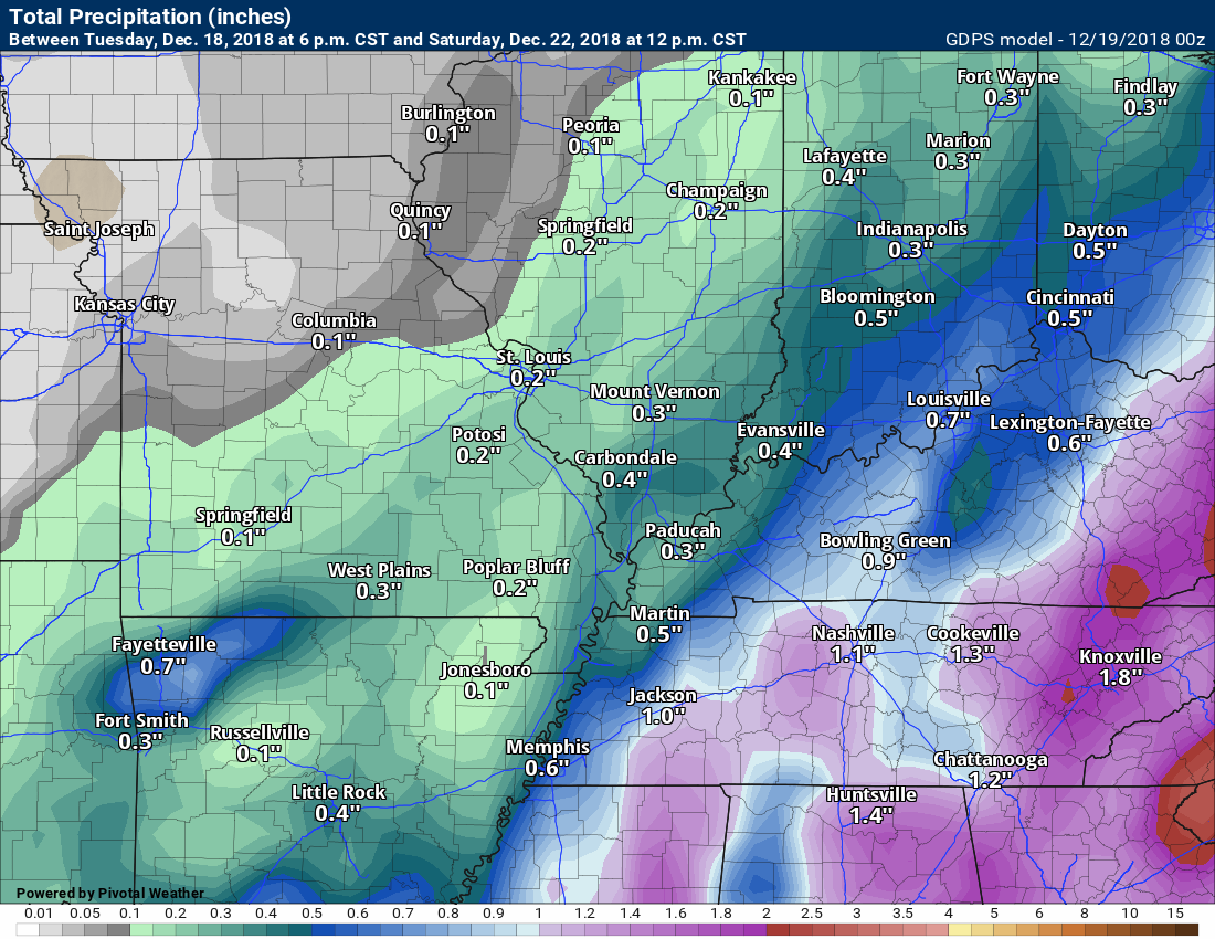
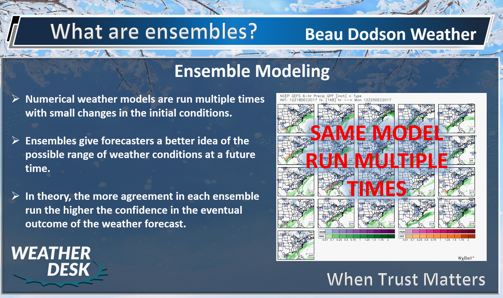
Let me show you a few of the model guidance packages.
Four models to show you today. These are rain totals with tonight’s rain event into Friday morning.
Notice how the higher totals are skewed to the east.
MODEL FORECAST RAIN TOTALS
NAM3K high resolution
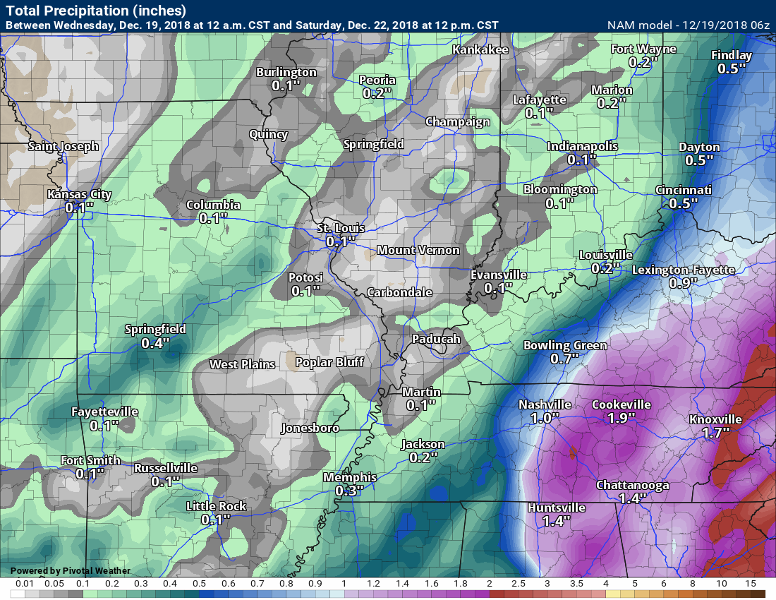
NAM
GFS
GEM Canadian
There is not enough instability for lightning. Severe weather is not a concern.
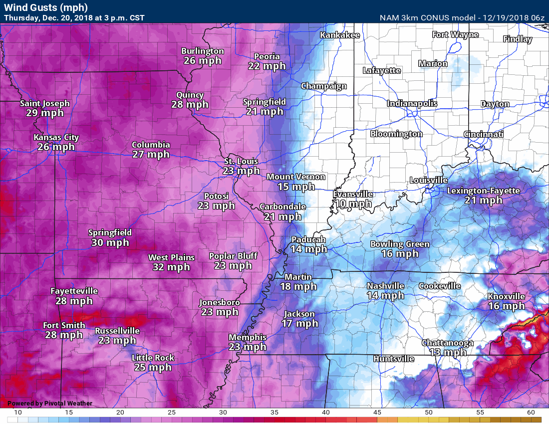
The pressure gradient will tighten up over the coming 72 hours. A tight barometric pressure gradient means gusty winds. The strongest winds will be Thursday night into Friday. Winds should top 30 mph from time to time. Loose Christmas decorations might be blown around.
Here is the NAM 3K wind gust forecast animation. The strongest winds will be Thursday night and Friday.
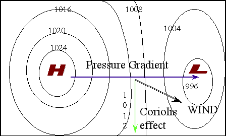
Here is the Friday morning pressure gradient. I drew in the isobars (equal lines of pressure). Notice how tight they are.
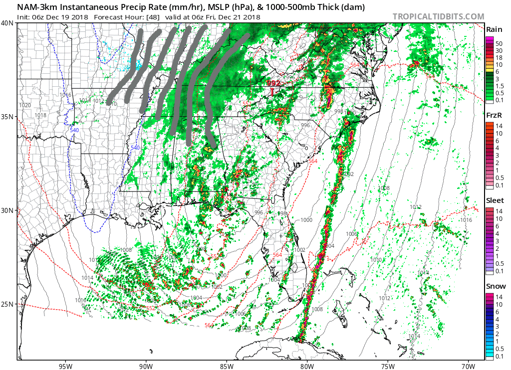
Here is another animation of the system. I pulled out a bit to show you the southeast United States.
Again, click image to enlarge it.
See how the system winds up to our southeast. You can see a line of intense thunderstorms along what would be the cold front.
That line will remain well to our south and east. No thunderstorm concerns here.
Keep scrolling down for the longer range outlook.
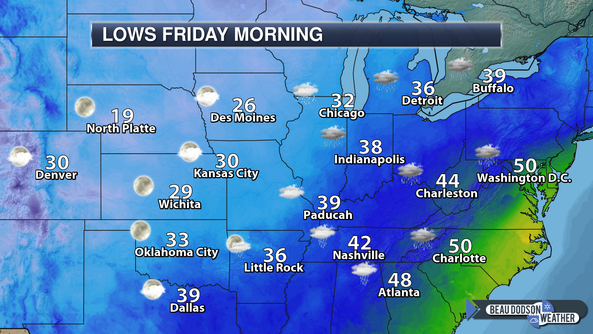
6 AM temperatures
The next two weather systems will be weak. One arrives Sunday night and another arrives Monday night/Tuesday morning.
Both of these systems could produce light rain or light snow. At this time, the chance of accumulating snow appears unlikely. As always, monitor updates.
Some of the guidance packages do show slightly more organized precipitation. I will be monitoring trends. Occasionally, these types of systems do produce surprises.
The Canadian model is a bit more organized with the Monday night event.
Here is that model’s depiction at 12 AM Monday. You can see light rain and snow in the region. Green is rain. Blue is snow.
Here is the 6 AM Monday depiction from the Canadian GEM model guidance. You can see rain showers and snow showers in the region.
This model is the most organized of all models.
The Canadian model even shows accumulating snow Sunday night/Monday morning.
The GFS model shows no snow accumulation. The ensemble data supports the GFS’s idea.
I will monitor trends, as always and update if need be.
The other models are showing a lighter event. They show less in the way of rain/snow totals. This appears to be a low-end precipitation event.
Let’s look at ensemble snow forecast totals.
The Canadian ensembles show no snow accumulation.
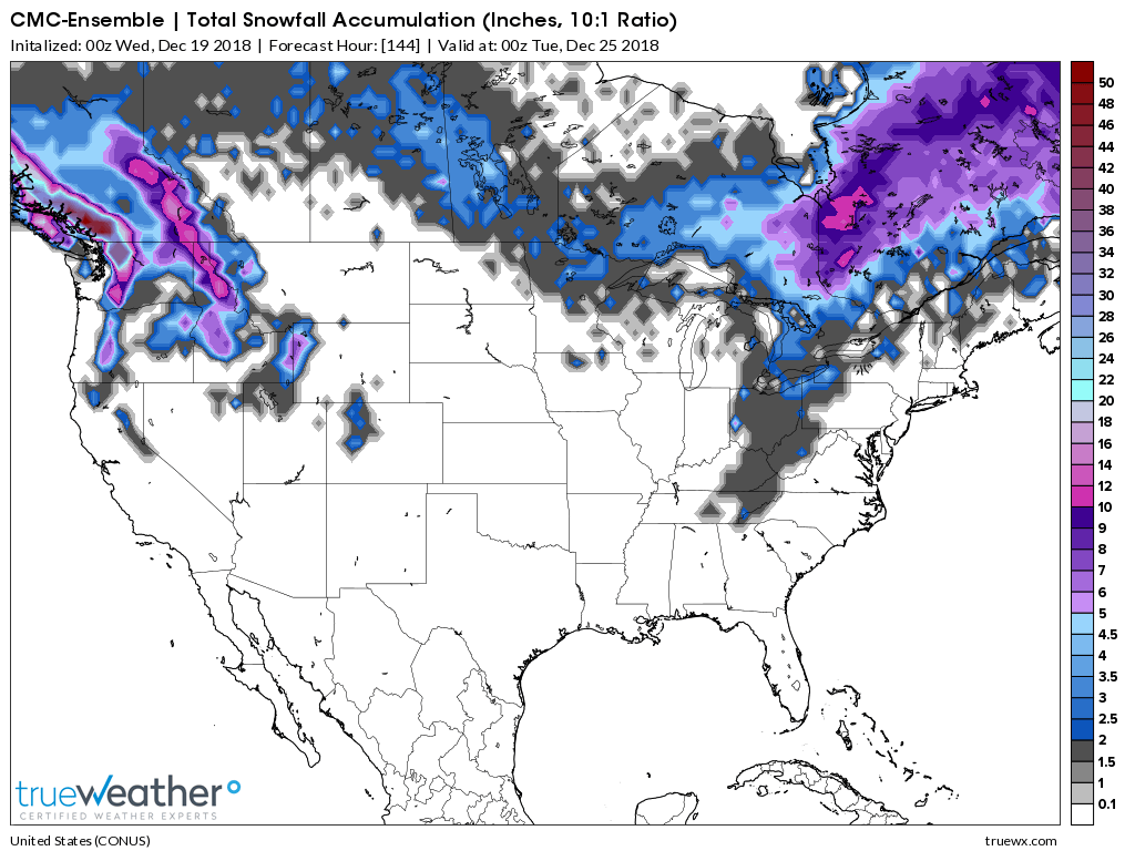
The GFS ensembles show little or snow accumulation.
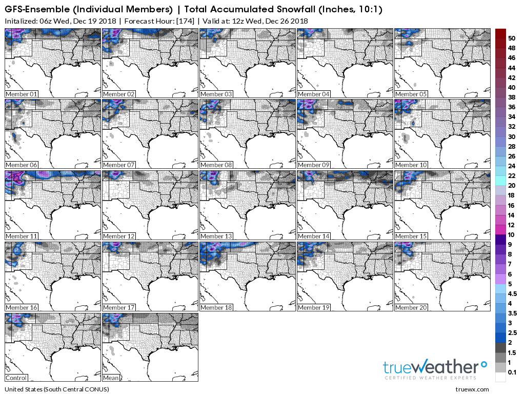
I will monitor trends.
Another rainmaker arrives around Wednesday night/Thursday.
Green is rain. Yellow is moderate rain. Blue is snow. Check out that heavy snow well to our north.
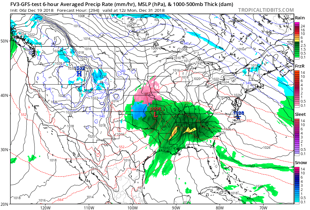
Here is yet another rainmaker around the 30th.
What about the so-called polar vortex that people are talking about?
There are some signals that a pool of colder air may move into the USA from Canada as we move into the first two weeks of January. The confidence in this happening is not all that great.
Yes, it is possible. The polar vortex is nothing new. It happens from time to time. It has happened since the dawn of man.
It is basically just a blast of cold arctic air that can produce well below normal temperatures.
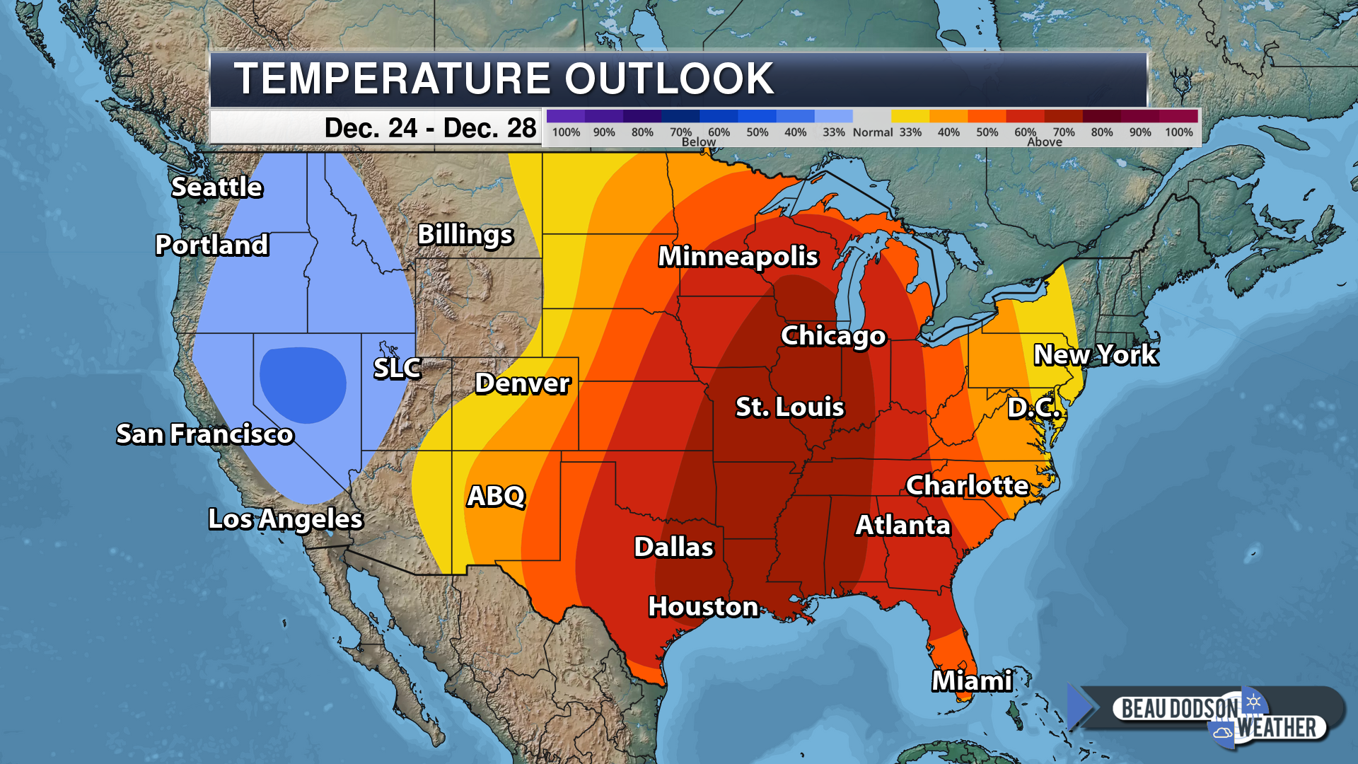
For now, the overall temperature outlook for the coming days will be at or above normal.
That should continue into part of next week.
That means December will end overall with above normal temperatures.
Here is the six to ten-day outlook from NOAA.
This shows you the probability of above or below normal temperatures (when averaged together).
We are favored in the above normal temperature departments.
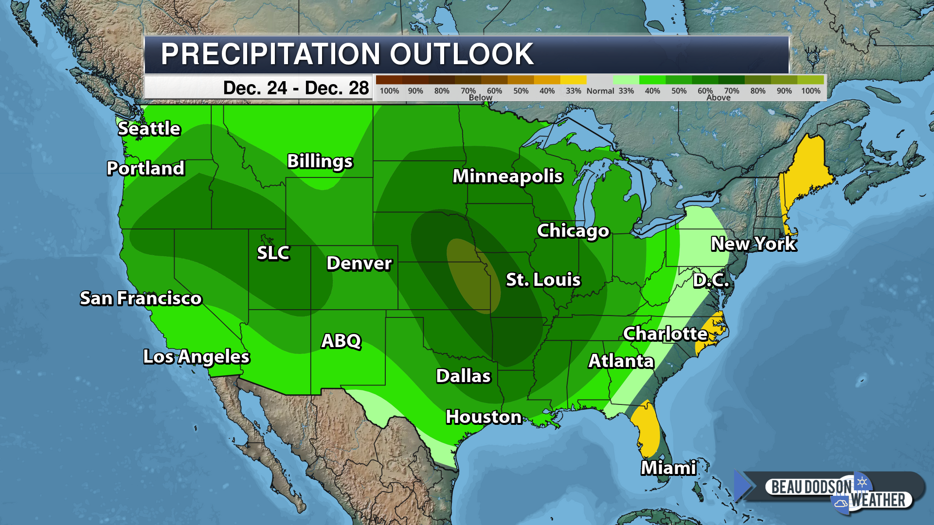
Here is the outlook for precipitation. Again, odds strongly favor wetter than normal.
I will keep monitoring snow chances. About your only hope right now is the Sunday night/Monday morning and Monday night events. For now, those appear to be light.
![]()

I bring these to you from the BAMwx team. They are excellent long-range forecasters.
Remember, long-range outlooks are a bit of skill, understanding weather patterns, and luck combined. It is not an exact science.

This product is for subscribers.
Subscribe at www.weathertalk.com
Subscriber graphics can be viewed on this page CLICK HERE

This product is for subscribers.

This product is for subscribers.
Subscribe at www.weathertalk.com
Subscriber graphics can be viewed on this page CLICK HERE
![]()
.
Winter Outlook!
These products are for subscribers.
December temperature and precipitation outlook
January temperature outlook
February temperature outlook
Winter snow outlook
.These products are for subscribers.
![]()

A new weather podcast is now available! Weather Geeks (which you might remember is on The Weather Channel each Sunday)
To learn more visit their website. Click here.
![]()

WeatherBrains Episode 674
Tonight’s Guest Panelist is a meteorologist recently retired as MIC from the NWS Birmingham. Jim Stefkovitch, welcome to the show!
Our second Guest Panelist is the MIC of the NWS in Atlanta. Keith Stellman, welcome to the show!
Tonight’s Guest WeatherBrain is a Professional of Sociology at Northwestern University. His PhD is from Harvard, and he has received numerous fellowships. In fact, he is probably the smartest person we have ever had on the show. Dr. Gary Alan Fine, welcome to WeatherBrains.
Other discussions in this weekly podcast include topics like:
- TV meteorologist tragically lost to suicide
- The role of politics in the day-to-day operations of the NWS
- Upcoming 5th anniversary of “Snowmageddon”
- Astronomy Outlook with Tony Rice
- and more!
Link to their website https://weatherbrains.com/
Previous episodes can be viewed by clicking here.

We offer interactive local city live radars and regional radars. If a radar does not update then try another one. If a radar does not appear to be refreshing then hit Ctrl F5. You may also try restarting your browser.
The local city view radars also have clickable warnings.
During the winter months, you can track snow and ice by clicking the winterize button on the local city view interactive radars.
You may email me at beaudodson@usawx.com
Find me on Facebook!

Find me on Twitter!

Did you know that a portion of your monthly subscription helps support local charity projects?
You can learn more about those projects by visiting the Shadow Angel Foundation website and the Beau Dodson News website.

I encourage subscribers to use the app vs regular text messaging. We have found text messaging to be delayed during severe weather. The app typically will receive the messages instantly. I recommend people have three to four methods of receiving their severe weather information.
Remember, my app and text alerts are hand typed and not computer generated. You are being given personal attention during significant weather events.
