
WeatherTalk monthly operating costs can top $2000.00. Your $5 subscription helps pay for those costs. I work for you.
The $5 will allow you to register up to seven phones!
For $5 a month you can receive the following. You may choose to receive these via your WeatherTalk app or regular text messaging.
Severe weather app/text alerts from my keyboard to your app/cell phone. These are hand typed messages from me to you. During tornado outbreaks, you will receive numerous app/text messages telling you exactly where the tornado is located.
- Daily forecast app/texts from my computer to your app/cell phone.
- Social media links sent directly to your app/cell phone. When I update the blog, videos, or Facebook you will receive the link.
- AWARE emails. These emails keep you well ahead of the storm. They give you several days of lead time before significant weather events.
- Direct access to Beau via text and email. Your very own personal meteorologist. I work for you!
- Missouri and Ohio Valley centered video updates
- Long-range weather videos
- Week one, two, three and four temperature and precipitation outlooks.
Monthly outlooks. - Your subscription also will help support several local charities.
Would you like to subscribe? Subscribe at www.beaudodsonweather.com
Typical progression on a severe weather day for subscribers.


I encourage subscribers to use the app vs regular text messaging. We have found text messaging to be delayed during severe weather. The app typically will receive the messages instantly. I recommend people have three to four methods of receiving their severe weather information.
Remember, my app and text alerts are hand typed and not computer generated. You are being given my personal attention during significant weather events.

WWW.WEATHERTALK.COM subscribers, here is my day to day schedule for your weather products.
These are bonus videos and maps for subscribers. I bring these to you from the BAMwx team. I pay them to help with videos.
The Ohio and Missouri Valley videos cover most of our area. They do not have a specific Tennessee Valley forecast but may add one in the future.
The long-range video is technical. Over time, you can learn a lot about meteorology from the long range video. Just keep in mind, it is a bit more technical.


Subscribe at www.weathertalk.com
![]()

December 18, 2018
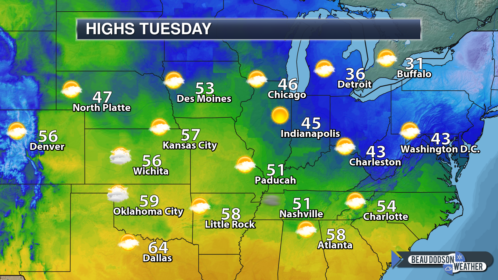
Tuesday forecast: Patchy morning fog. Mostly sunny with a few clouds from time to time. Cool.
My confidence in the forecast verifying: High (80% confidence in the forecast)
Temperature range: MO ~ 48 to 54 IL ~ 46 to 52 KY ~ 48 to 54 TN ~ 50 to 54
Wind chill (feels like) temperature forecast:
What is the chance/probability of precipitation? MO ~ 0% IL ~ 0% KY ~ 0% TN ~ 0%
Coverage of precipitation: None
Is flooding anticipated? No
Is accumulating snow or ice anticipated? No
Is non-accumulating snow or ice anticipated? No
Are icy road conditions anticipated? No
Wind direction and speed: Variable at 4 to 8 mph
What impacts are anticipated from the weather? Perhaps some morning patchy fog with reduced visibility
Is severe weather expected? No
The NWS officially defines severe weather as 58 mph wind or great, 1″ hail or larger, and/or tornadoes
Will lightning be possible? No
Should I cancel my outdoor plans? No
Will the weather impact my outdoor plans? No
UV Index: 3 Medium
Sunrise: 7:04 AM
Tuesday Night Forecast Details:
Forecast: Mostly clear early. Some late night clouds. Cool. Patchy fog.
My confidence in the forecast verifying: High (70% confidence in the forecast)
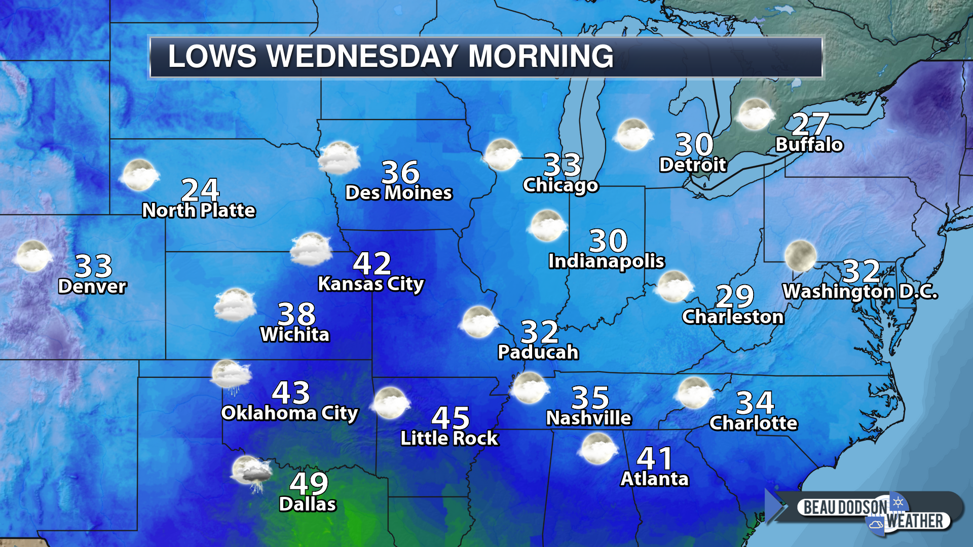
Temperature range: MO ~ 28 to 34 IL ~ 28 to 34 KY ~ 30 to 35 TN ~ 30 to 35
Wind chill (feels like) temperature forecast: 28 to 35
What is the chance/probability of precipitation? MO ~ 0% IL ~ 0% KY ~ 0% TN ~ 0%
Coverage of precipitation: None
Is flooding anticipated? No
Is accumulating snow or ice anticipated? No
Is non-accumulating snow or ice anticipated? No
Are icy road conditions anticipated? No
Wind direction and speed: Southeast at 5 mph
What impacts are anticipated from the weather? None
Is severe weather expected? No
The NWS officially defines severe weather as 58 mph wind or great, 1″ hail or larger, and/or tornadoes
Will lightning be possible? No
Should I cancel my outdoor plans? No
Will the weather impact my outdoor plans? No
Sunset: 4:39 PM
Moonrise: 2:00 PM Waxing Crescent
Moonset: 2:22 AM
December 19, 2018
Wednesday forecast: Increasing clouds through the day.
My confidence in the forecast verifying: Medium (40% confidence in the forecast)
Temperature range: MO ~ 54 to 58 IL ~54 to 56 KY ~ 54 to 58 TN ~ 54 to 58
Wind chill (feels like) temperature forecast: N/A
What is the chance/probability of precipitation? MO ~ 20% IL ~ 0% KY ~ 0% TN ~ 0%
Coverage of precipitation: None AM hours. None to isolated PM hours. (MO)
Is flooding anticipated? No
Is accumulating snow or ice anticipated? No
Is non-accumulating snow or ice anticipated? No
Are icy road conditions anticipated? No
Wind direction and speed: South and southwest at 5 to 10 mph with gusts to 14 mph
What impacts are anticipated from the weather? Perhaps some isolated wet roadways.
Is severe weather expected? No
The NWS officially defines severe weather as 58 mph wind or great, 1″ hail or larger, and/or tornadoes
Will lightning be possible? No
Should I cancel my outdoor plans? No
Will the weather impact my outdoor plans? Most of the day will be dry. Isolate late PM shower over southeast Missouri.
UV Index: 3 to 4 Medium
Sunrise: 7:05 AM
Wednesday Night Forecast Details:
Forecast: Cloudy. Rain showers developing.
My confidence in the forecast verifying: High (70% confidence in the forecast)
Temperature range: MO ~ 40 to 45 IL ~ 40 to 45 KY ~ 40 to 45 TN ~ 40 to 45
Wind chill (feels like) temperature forecast: 35 to 40
What is the chance/probability of precipitation? MO ~ 70% IL ~ 50% KY ~ 60% TN ~ 60%
Coverage of precipitation: Scattered to perhaps numerous
Is flooding anticipated? No
Is accumulating snow or ice anticipated? No
Is non-accumulating snow or ice anticipated? No
Are icy road conditions anticipated? No
Wind direction and speed: Southw and southwest at 10 to 20 mph
What impacts are anticipated from the weather? Wet roadways.
Is severe weather expected? No
The NWS officially defines severe weather as 58 mph wind or great, 1″ hail or larger, and/or tornadoes
Will lightning be possible? Most likely no
Should I cancel my outdoor plans? I would not cancel evening plans. I would monitor updates and radars. The exact timing of the rain moving into the region is still a bit of a question.
Will the weather impact my outdoor plans? Rain could cause issues for outdoor activities, especially as we move later into the night.
Sunset: 4:40 PM
Moonrise: 2:35 PM Waxing Crescent
Moonset: 3:26 AM
December 20, 2018
Thursday forecast: Rain likely. Becoming breezy.
My confidence in the forecast verifying: Medium (60% confidence in the forecast)
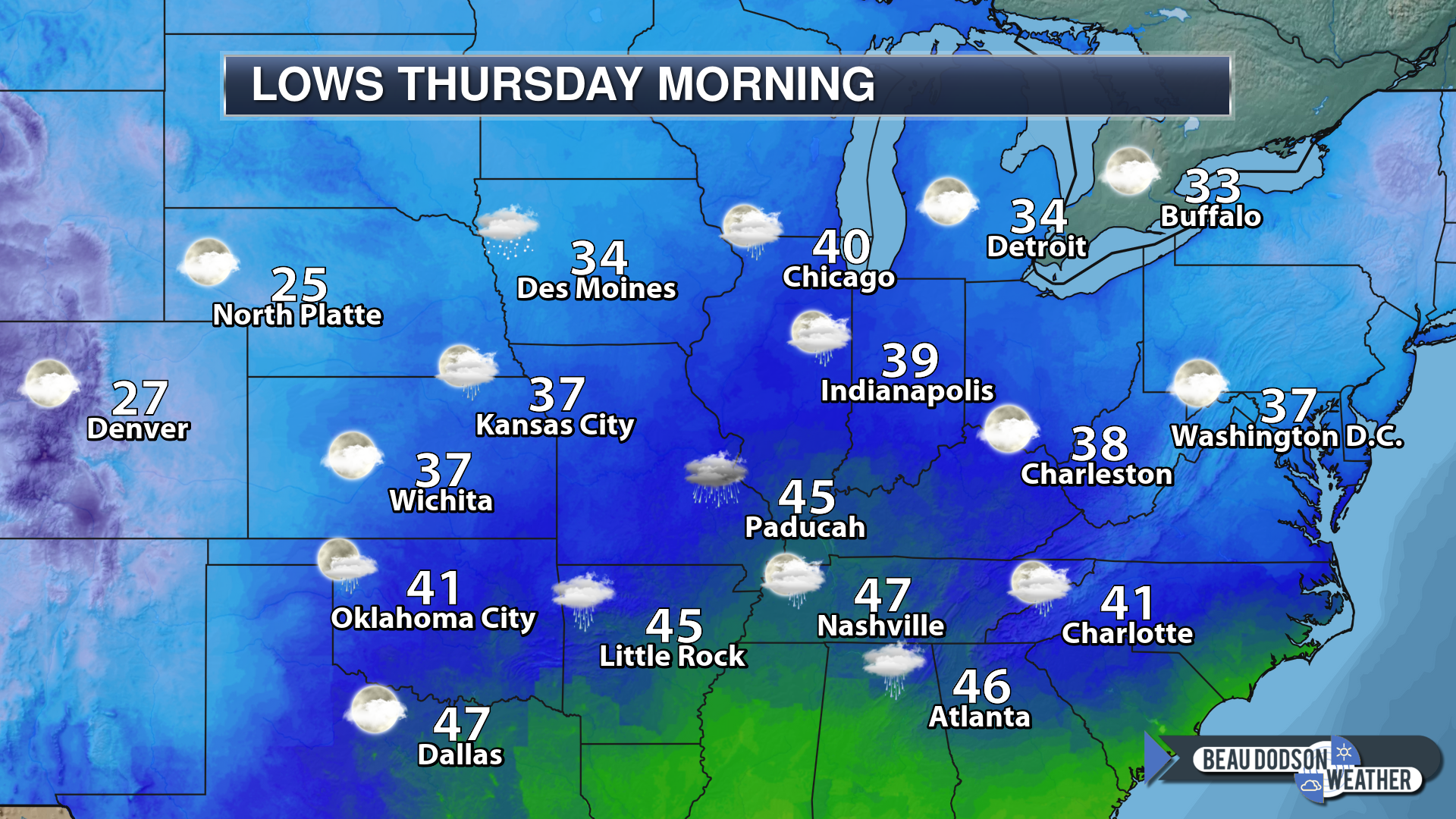
Temperature range: MO ~ 48 to 52 IL ~48 to 52 KY ~ 48 to 52 TN ~ 50 to 54
Wind chill (feels like) temperature forecast: 40 to 45
What is the chance/probability of precipitation? MO ~ 70% IL ~ 70% KY ~ 70% TN ~ 70%
Coverage of precipitation: Numerous
Is flooding anticipated? No
Is accumulating snow or ice anticipated? No
Is non-accumulating snow or ice anticipated? No
Are icy road conditions anticipated? No
Wind direction and speed: West and northwest at 12 to 24 mph and gusty. Winds will be variable at times.
What impacts are anticipated from the weather? Wet roadways
Is severe weather expected? No
The NWS officially defines severe weather as 58 mph wind or great, 1″ hail or larger, and/or tornadoes
Will lightning be possible? No
Should I cancel my outdoor plans? Have a plan B
Will the weather impact my outdoor plans? Wet conditions will interfere with outdoor activities. Gusty winds will also be an issue.
UV Index: 1 to 2 Low
Sunrise: 7:05 AM
Thursday Night Forecast Details:
Forecast: Rain likely. Breezy. Turning colder. Rain may end with a rain/snow mix with no accumulation.
My confidence in the forecast verifying: Medium (40% confidence in the forecast)
Temperature range: MO ~ 32 to 35 IL ~ 32 to 35 KY ~ 34 to 36 TN ~ 34 to 36
Wind chill (feels like) temperature forecast: 18 to 28
What is the chance/probability of precipitation? MO ~ 70% IL ~ 70% KY ~ 70% TN ~ 70%
Coverage of precipitation: Numerous
Is flooding anticipated? No
Is accumulating snow or ice anticipated? Not at this time.
Is non-accumulating snow or ice anticipated? It appears the rain may end before the colder air arrives. Perhaps some rain/snow mix at the end.
Are icy road conditions anticipated? No
Wind direction and speed: Northwest 15 to 30 mph and gusty
What impacts are anticipated from the weather? Wet roads and gusty wind conditions.
Is severe weather expected? No
The NWS officially defines severe weather as 58 mph wind or great, 1″ hail or larger, and/or tornadoes
Will lightning be possible? No
Should I cancel my outdoor plans? Have a plan B
Will the weather impact my outdoor plans? Yes. Damp conditions combined with strong winds will make it feel uncomfortable outside. I am monitoring the snow chances, as well. It appears the rain may end before the colder air arrives. Monitor updates in case this changes.
Sunset: 4:40 PM
Moonrise: 3:15 PM Waxing Crescent
Moonset: 4:32 AM
December 21, 2018
Friday forecast: Rain ending from west to east. Low chance that the rain may end as a wintry mix or snow. It is likely the cold air holds off just long enough for this to end as plain rain.
My confidence in the forecast verifying: Medium (40% confidence in the forecast)
Temperature range: MO ~ 38 to 44 IL ~ 38 to 44 KY ~ 38 to 44 TN ~ 38 to 44
Wind chill (feels like) temperature forecast: 15 to 30
What is the chance/probability of precipitation? MO ~ 30% IL ~ 40% KY ~ 50% TN ~ 40%
Coverage of precipitation: Ending west to east during the AM hours
Is flooding anticipated? No
Is accumulating snow or ice anticipated? The precipitation may end before the cold air arrives.
Is non-accumulating snow or ice anticipated? A rain/snow mix is possible as the precipitation ends. No accumulation.
Are icy road conditions anticipated? No
Wind direction and speed: Northwest at 15 to 30 mph and gusty
What impacts are anticipated from the weather? Damp. Cold wind chill values. Wet roadways.
Is severe weather expected? No
The NWS officially defines severe weather as 58 mph wind or great, 1″ hail or larger, and/or tornadoes
Will lightning be possible? No
Should I cancel my outdoor plans? Have a plan B before 10 AM and monitor updates.
Will the weather impact my outdoor plans? Yes. Cold wind chill values combined with damp conditions will make it unpleasant.
UV Index: 3 Medium
Sunrise: 7:06 AM
Friday Night Forecast Details:
Forecast: Mostly clear and cold.
My confidence in the forecast verifying: Medium (60% confidence in the forecast)
Temperature range: MO ~ 25 to 30 IL ~ 25 to 30 KY ~ 25 to 30 TN ~ 25 to 30
Wind chill (feels like) temperature forecast: 18 to 24
What is the chance/probability of precipitation? MO ~ 0% IL ~ 0% KY ~ 0% TN ~ 0%
Coverage of precipitation: None
Is flooding anticipated? No
Is accumulating snow or ice anticipated? No
Is non-accumulating snow or ice anticipated? No
Are icy road conditions anticipated? No
Wind direction and speed: West at 6 to 12 mph with gusts to 20 mph
What impacts are anticipated from the weather? None
Is severe weather expected? No
The NWS officially defines severe weather as 58 mph wind or great, 1″ hail or larger, and/or tornadoes
Will lightning be possible? No
Should I cancel my outdoor plans? No
Will the weather impact my outdoor plans? Other than cold temperatures, no.
Sunset: 4:41 PM
Moonrise: 4:03 PM Waxing Crescent
Moonset: 5:42 AM
December 22, 2018
Saturday forecast: Mostly sunny. Cool.
My confidence in the forecast verifying: Medium (40% confidence in the forecast)
Temperature range: MO ~ 48 to 52 IL ~48 to 52 KY ~ 48 to 52 TN ~ 48 to 52
Wind chill (feels like) temperature forecast: 45 to 50
What is the chance/probability of precipitation? MO ~ 0% IL ~ 0% KY ~ 0% TN ~ 0%
Coverage of precipitation: None
Is flooding anticipated? No
Is accumulating snow or ice anticipated? No
Is non-accumulating snow or ice anticipated? No
Are icy road conditions anticipated? No
Wind direction and speed: West and northwest at 5 to 10 mph. Wind becoming southwest.
What impacts are anticipated from the weather? None
Is severe weather expected? No
The NWS officially defines severe weather as 58 mph wind or great, 1″ hail or larger, and/or tornadoes
Will lightning be possible? No
Should I cancel my outdoor plans? No
Will the weather impact my outdoor plans? None
UV Index: 2 Low
Sunrise: 7:06 AM
Saturday Night Forecast Details:
Forecast: A few clouds. Cool.
My confidence in the forecast verifying: Medium (60% confidence in the forecast)
Temperature range: MO ~ 26 to 32 IL ~ 26 to 32 KY ~ 28 to 32 TN ~ 30 to 34
Wind chill (feels like) temperature forecast:
What is the chance/probability of precipitation? MO ~ 0% IL ~ 0% KY ~ 0% TN ~ 0%
Coverage of precipitation: None
Is flooding anticipated? No
Is accumulating snow or ice anticipated? No
Is non-accumulating snow or ice anticipated? No
Are icy road conditions anticipated? No
Wind direction and speed: Southwest and west at 5 to 10 mph. Wind becoming northwest.
What impacts are anticipated from the weather? None
Is severe weather expected? No
The NWS officially defines severe weather as 58 mph wind or great, 1″ hail or larger, and/or tornadoes
Will lightning be possible? No
Should I cancel my outdoor plans? No
Will the weather impact my outdoor plans? None
Sunset: 4:41 PM
Moonrise: 4:57 PM Full
Moonset: 6:48 AM
December 23, 2018
Sunday forecast: Partly cloudy.
My confidence in the forecast verifying: Low (30% confidence in the forecast)
Temperature range: MO ~ 43 to 46 IL ~43 to 46 KY ~ 43 to 46 TN ~ 44 to 48
Wind chill (feels like) temperature forecast:
What is the chance/probability of precipitation? MO ~ 10% IL ~ 10% KY ~ 10% TN ~ 20%
Coverage of precipitation: Most likely none, but monitor updates
Is flooding anticipated? No
Is accumulating snow or ice anticipated? No
Is non-accumulating snow or ice anticipated? No
Are icy road conditions anticipated? No
Wind direction and speed: North and northwest at 5 to 10 mph
What impacts are anticipated from the weather? Most likely none.
Is severe weather expected? No
The NWS officially defines severe weather as 58 mph wind or great, 1″ hail or larger, and/or tornadoes
Will lightning be possible? No
Should I cancel my outdoor plans? No
Will the weather impact my outdoor plans? None
UV Index: 2 Low
Sunrise: 7:07 AM
Sunday Night Forecast Details:
Forecast: Partly cloudy.
My confidence in the forecast verifying: Medium (40% confidence in the forecast)
Temperature range: MO ~ 28 to 34 IL ~ 28 to 34 KY ~ 32 to 36 TN ~ 32 to 36
Wind chill (feels like) temperature forecast: 25 to 30
What is the chance/probability of precipitation? MO ~ 0% IL ~ 0% KY ~ 0% TN ~ 0%
Coverage of precipitation: None
Is flooding anticipated? No
Is accumulating snow or ice anticipated? No
Is non-accumulating snow or ice anticipated? No
Are icy road conditions anticipated? No
Wind direction and speed: Variable at 5 to 10 mph
What impacts are anticipated from the weather? None
Is severe weather expected? No
The NWS officially defines severe weather as 58 mph wind or great, 1″ hail or larger, and/or tornadoes
Will lightning be possible? No
Should I cancel my outdoor plans? No
Will the weather impact my outdoor plans? Most likely no impacts.
Sunset: 4:42 PM
Moonrise: 6:00 PM Waning Gibbous
Moonset: 7:53 AM
Another system may bring additional rain to the region on Monday and Tuesday. There remain questions about how much moisture will be available for it to tap into.
For now, it appears that this would be a rain event. With that said, different guidance packages show different ideas. If you have travel plans Christmas Eve and Christmas Day then monitor updates.
December 24, 2018
Christmas Eve
Monday forecast: Partly cloudy.
My confidence in the forecast verifying: Medium (40% confidence in the forecast)
Temperature range: MO ~ 44 to 48 IL ~44 to 48 KY ~ 44 to 48 TN ~ 44 to 48
Wind chill (feels like) temperature forecast:
What is the chance/probability of precipitation? MO ~ 10% IL ~ 10% KY ~ 10% TN ~ 10%
Coverage of precipitation: None
Is flooding anticipated? No
Is accumulating snow or ice anticipated? No
Is non-accumulating snow or ice anticipated? No
Are icy road conditions anticipated? No
Wind direction and speed: East and southeast at 5 to 10 mph
What impacts are anticipated from the weather? None
Is severe weather expected? No
The NWS officially defines severe weather as 58 mph wind or great, 1″ hail or larger, and/or tornadoes
Will lightning be possible? No
Should I cancel my outdoor plans? No
Will the weather impact my outdoor plans? No
UV Index: 2 Low
Sunrise: 7:07 AM
Monday Night Forecast Details:
Christmas Eve
Forecast: Partly cloudy. A slight chance of a shower.
My confidence in the forecast verifying: Low (20% confidence in the forecast)
Temperature range: MO ~ 38 to 44 IL ~ 38 to 44 KY ~ 38 to 44 TN ~ 38 to 44
Wind chill (feels like) temperature forecast: 25 to 30
What is the chance/probability of precipitation? MO ~ 20% IL ~ 20% KY ~ 20% TN ~ 20%
Coverage of precipitation: None to isolated
Is flooding anticipated? No
Is accumulating snow or ice anticipated? Most likely no
Is non-accumulating snow or ice anticipated? Most likely no
Are icy road conditions anticipated? No
Wind direction and speed: Southeast at 7 to 14 mph
What impacts are anticipated from the weather? None to isolated wet roadways.
Is severe weather expected? No
The NWS officially defines severe weather as 58 mph wind or great, 1″ hail or larger, and/or tornadoes
Will lightning be possible? No
Should I cancel my outdoor plans? No
Will the weather impact my outdoor plans? No
Sunset: 4:42 PM
Moonrise: 7:08 PM Waning Gibbous
Moonset: 8:52 AM
December 25, 2018
Christmas
Tuesday forecast: Partly sunny. A slight chance of a shower.
My confidence in the forecast verifying: Low (30% confidence in the forecast)
Temperature range: MO ~ 44 to 48 IL ~44 to 48 KY ~ 44 to 48 TN ~ 44 to 48
Wind chill (feels like) temperature forecast:
What is the chance/probability of precipitation? MO ~ 20% IL ~ 20% KY ~ 20% TN ~ 20%
Coverage of precipitation: None to isolated
Is flooding anticipated? No
Is accumulating snow or ice anticipated? Unlikely
Is non-accumulating snow or ice anticipated? Unlikely
Are icy road conditions anticipated? No
Wind direction and speed: Southwest to west at 7 to 14 mph
What impacts are anticipated from the weather? Isolated wet roadways.
Is severe weather expected? No
The NWS officially defines severe weather as 58 mph wind or great, 1″ hail or larger, and/or tornadoes
Will lightning be possible? No
Should I cancel my outdoor plans? No
Will the weather impact my outdoor plans? Most likely no
UV Index: 2 Low
Sunrise: 7:07 AM
Tuesday Night Forecast Details:
Christmas Night
Forecast: Partly cloudy. A slight chance of a shower or snow flurry.
My confidence in the forecast verifying: Low (20% confidence in the forecast)
Temperature range: MO ~ 35 to 40 IL ~ 35 to 40 KY ~ 35 to 40 TN ~ 35 to 40
Wind chill (feels like) temperature forecast: 30 to 35
What is the chance/probability of precipitation? MO ~ 20% IL ~ 20% KY ~ 20% TN ~ 20%
Coverage of precipitation: None to isolated
Is flooding anticipated? No
Is accumulating snow or ice anticipated? Most likely no
Is non-accumulating snow or ice anticipated? Most likely no
Are icy road conditions anticipated? No
Wind direction and speed: Northwest at 6 to 12 mph
What impacts are anticipated from the weather? None to isolated wet roadways.
Is severe weather expected? No
The NWS officially defines severe weather as 58 mph wind or great, 1″ hail or larger, and/or tornadoes
Will lightning be possible? No
Should I cancel my outdoor plans? No
Will the weather impact my outdoor plans? Most likely no
Sunset: 4:43 PM
Moonrise: 8:19 PM Waning Gibbous
Moonset: 9:44 AM
December 26, 2018
Wednesday Forecast: Partly sunny. Clouds increasing during the PM hours. A slight chance of a shower.
My confidence in the forecast verifying: Low (30% confidence in the forecast)
Temperature range: MO ~ 50 to 55 IL ~ 50 to 55 KY ~ 50 to 55 TN ~ 50 to 55
Wind chill (feels like) temperature forecast:
What is the chance/probability of precipitation? MO ~ 20% IL ~ 20% KY ~ 20% TN ~ 20%
Coverage of precipitation: None to isolated PM hours
Is flooding anticipated? No
Is accumulating snow or ice anticipated? No
Is non-accumulating snow or ice anticipated? No
Are icy road conditions anticipated? No
Wind direction and speed: Southeast at 7 to 14 mph
What impacts are anticipated from the weather? Most likely none.
Is severe weather expected? No
The NWS officially defines severe weather as 58 mph wind or great, 1″ hail or larger, and/or tornadoes
Will lightning be possible? No
Should I cancel my outdoor plans? No
Will the weather impact my outdoor plans? Most likely no
UV Index: 2 Low
Sunrise: 7:08 AM
Wednesday Night Forecast Details:
Forecast: Cloudy. A chance of showers developing late.
My confidence in the forecast verifying: Low (30% confidence in the forecast)
Temperature range: MO ~ 44 to 48 IL ~ 44 to 48 KY ~ 45 to 50 TN ~ 45 to 50
Wind chill (feels like) temperature forecast:
What is the chance/probability of precipitation? MO ~ 30% IL ~ 20% KY ~ 20% TN ~ 20%
Coverage of precipitation: None to scattered
Is flooding anticipated? No
Is accumulating snow or ice anticipated? No
Is non-accumulating snow or ice anticipated? No
Are icy road conditions anticipated? No
Wind direction and speed: South at 6 to 12 mph with gusts to 20 mph
What impacts are anticipated from the weather? Wet roadways.
Is severe weather expected? Most likely no, but monitor updates.
The NWS officially defines severe weather as 58 mph wind or great, 1″ hail or larger, and/or tornadoes
Will lightning be possible? Unlikely
Should I cancel my outdoor plans? Not at this time.
Will the weather impact my outdoor plans? Rain could cause damp conditions. The timing of the rain is still in question. Monitor updates.
Sunset: 4:43 PM
Moonrise: 9:30 PM Waning Gibbous
Moonset: 10:28 AM
December 27, 2018
Thursday Forecast: Cloudy. A chance of showers. A thunderstorm possible.
My confidence in the forecast verifying: Medium (40% confidence in the forecast)
Temperature range: MO ~ 54 to 58 IL ~ 54 to 58 KY ~ 54 to 58 TN ~ 54 to 58
Wind chill (feels like) temperature forecast:
What is the chance/probability of precipitation? MO ~ 40% IL ~ 40% KY ~ 40% TN ~ 40%
Coverage of precipitation: Scattered
Is flooding anticipated? No
Is accumulating snow or ice anticipated? No
Is non-accumulating snow or ice anticipated? No
Are icy road conditions anticipated? No
Wind direction and speed: South and southwest at 8 to 16 mph
What impacts are anticipated from the weather? Wet roadways. Perhaps lightning. Low confidence in the lightning.
Is severe weather expected? Monitor updates
The NWS officially defines severe weather as 58 mph wind or great, 1″ hail or larger, and/or tornadoes
Will lightning be possible? Yes
Should I cancel my outdoor plans? Monitor updates
Will the weather impact my outdoor plans? Rain could cause wet conditions for outdoor activities. I would suggest monitoring updates. This is still in the long range.
UV Index: 2 Low
Sunrise: 7:08 AM
Thursday Night Forecast Details:
Forecast: Cloudy. A chance of showers. A thunderstorm possible.
My confidence in the forecast verifying: Low (30% confidence in the forecast)
Temperature range: MO ~ 44 to 48 IL ~ 44 to 48 KY ~ 45 to 50 TN ~ 45 to 50
Wind chill (feels like) temperature forecast:
What is the chance/probability of precipitation? MO ~ 40% IL ~ 40% KY ~ 40% TN ~ 40%
Coverage of precipitation: Scattered
Is flooding anticipated? No
Is accumulating snow or ice anticipated? No
Is non-accumulating snow or ice anticipated? No
Are icy road conditions anticipated? No
Wind direction and speed: South at 6 to 12 mph with gusts to 20 mph
What impacts are anticipated from the weather? Wet roadways. Perhaps lightning. Low confidence in the lightning.
Is severe weather expected? Most likely no, but monitor updates.
The NWS officially defines severe weather as 58 mph wind or great, 1″ hail or larger, and/or tornadoes
Will lightning be possible? Perhaps
Should I cancel my outdoor plans? Monitor
Will the weather impact my outdoor plans? Rain could cause damp conditions. Monitor updates.
Sunset: 4:44PM
Moonrise: 10:35 PM Waning Gibbous
Moonset: 11:08 AM
Learn more about the UV index readings. Click here.
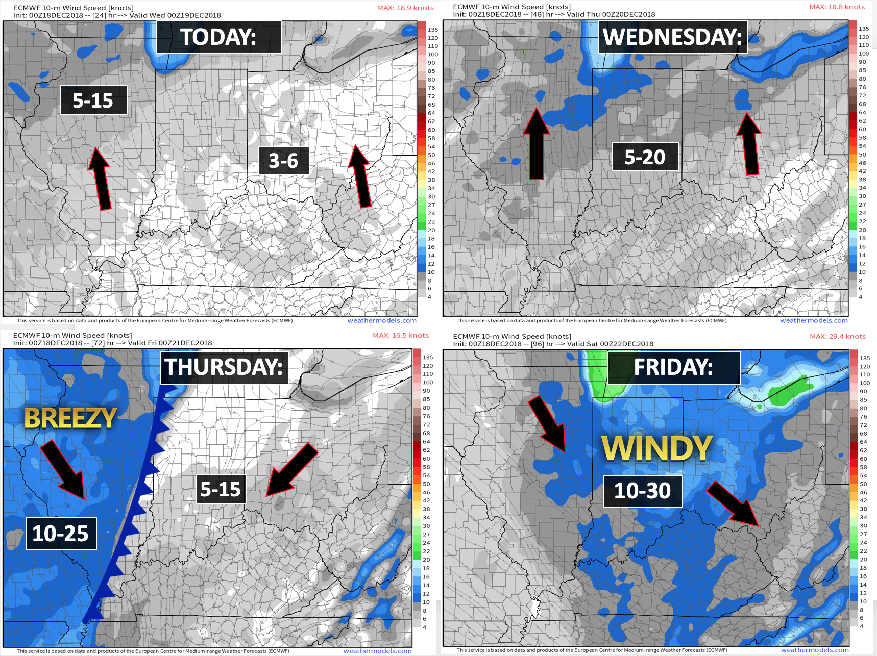
Wind forecast
Click to enlarge
.

Today: Wintry precipitation is not anticipated.
Wednesday: Wintry precipitation is not anticipated.
Thursday: Wintry precipitation is not anticipated. Rain is in the forecast.
Thursday night: There is a small chance the rain ends as snow or a wintry mix. For now, it appears this is a rain event.
Friday: There is a small chance the rain ends as snow or a wintry mix. No accumulation.
Saturday: Wintry precipitation is not anticipated.
Sunday: Wintry precipitation is not anticipated.
Monday: Wintry precipitation is not anticipated.
Tuesday: At this time, wintry precipitation is not anticipated.

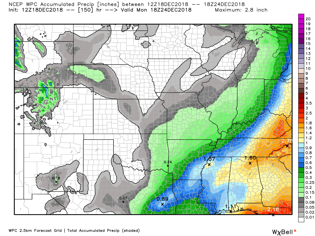
Here is the WPC/NOAA rainfall outlook
Click to enlarge.
The next rain event will arrive Wednesday night into Thursday night. Rain totals should not be as heavy as this recent event.
You can expect a widespread 0.40″ to 0.80″ rain event. This number has been in flux.
Click to enlarge graphics on the blog.
Did you know that you can find me on Twitter?

Subscribers, do you need a forecast for an outdoor event?


We offer interactive local city live radars and regional radars.
If a radar does not update then try another one. If a radar does not appear to be refreshing then hit Ctrl F5 on your keyboard.
You may also try restarting your browser. The local city view radars also have clickable warnings.
During the winter months, you can track snow and ice by clicking the winterize button on the local city view interactive radars.

Questions? Broken links? Other questions?
You may email me at beaudodson@usawx.com

The National Weather Service defines a severe thunderstorm as one that produces quarter size hail or larger, 58 mph winds or greater, and/or a tornado.
Today through next Tuesday: No severe weather.
Interactive live weather radar page. Choose the city nearest your location. If one of the cities does not work then try a nearby one. Click here.
National map of weather watches and warnings. Click here.
Storm Prediction Center. Click here.
Weather Prediction Center. Click here.

Live lightning data: Click here.

Interactive GOES R satellite. Track clouds. Click here.

Here are the latest local river stage forecast numbers Click Here.
Here are the latest lake stage forecast numbers for Kentucky Lake and Lake Barkley Click Here.

- Another nice day of weather. A little cool. Not too bad for the middle of December.
- Rain chances will increase as we move into Wednesday night. The rain will linger into Thursday night.
- Conditions should be dry most of Friday into Wednesday. There is a weak system showing up on Monday night into Tuesday night. For now, I kept precipitation chances low.
- I am tracking another system towards next Wednesday night into Thursday night.
A calm weather day ahead of us. Temperatures will be above normal. Not too bad for the middle of December.
December has delivered more above normal temperature days than below normal temperature days. November was the complete opposite.
We have had more below normal temperature days this month than above normal.
The above normal temperatures, however, have been greater in degree.
Here is the preliminary month to date numbers for the Paducah, KY area.
Orange is an above normal temperature day. Blue is a below normal temperature day.
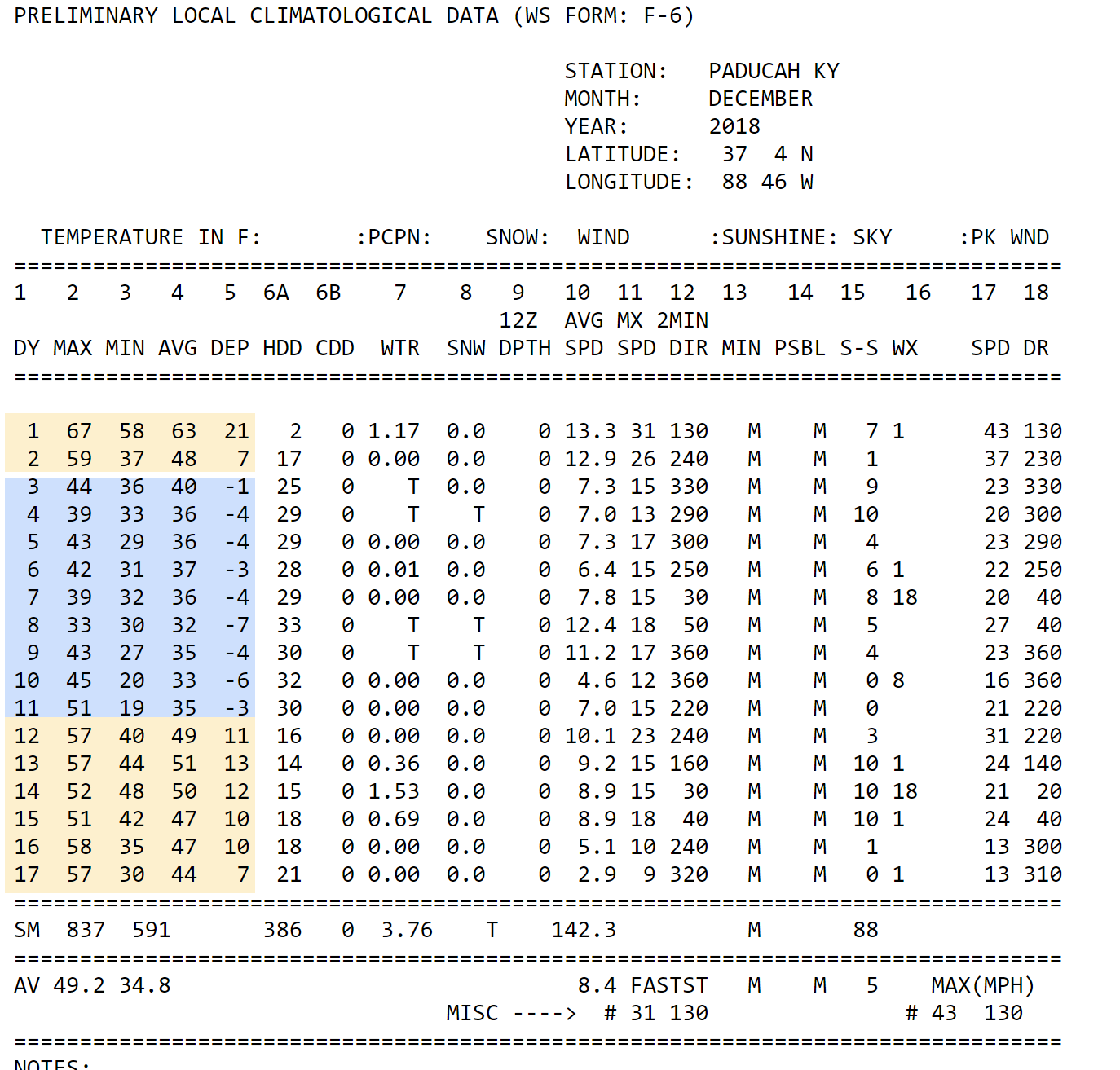
6 AM temperatures
Although the weather is quiet today, it won’t remain that way for long.
Another rainmaker is already taking shape to our west and southwest.
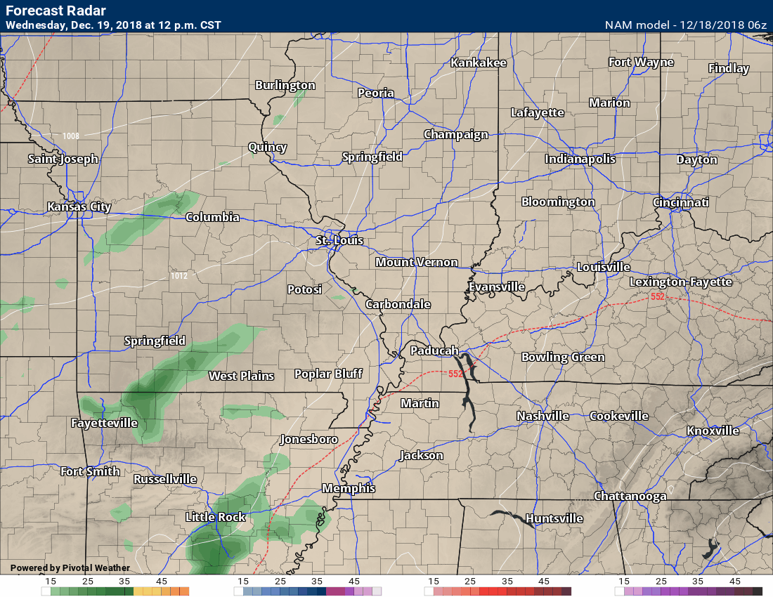
This system will gather some strength and push towards our region Wednesday night and will linger into early Friday morning.
This is another rain event for our region. I can’t completely rule out the rain ending as light snow or a mix. No accumulation.
It will turn colder behind the cold front Friday. Nothing too extreme.
No severe weather, either.
This does not look to be a heavy rain event. The last event did produce some moderate to heavy rain totals across the region. This one won’t be as wet.
Rain totals Wednesday night into Thursday night will likely range from 0.40″ to 0.80″ with pockets of locally higher totals.
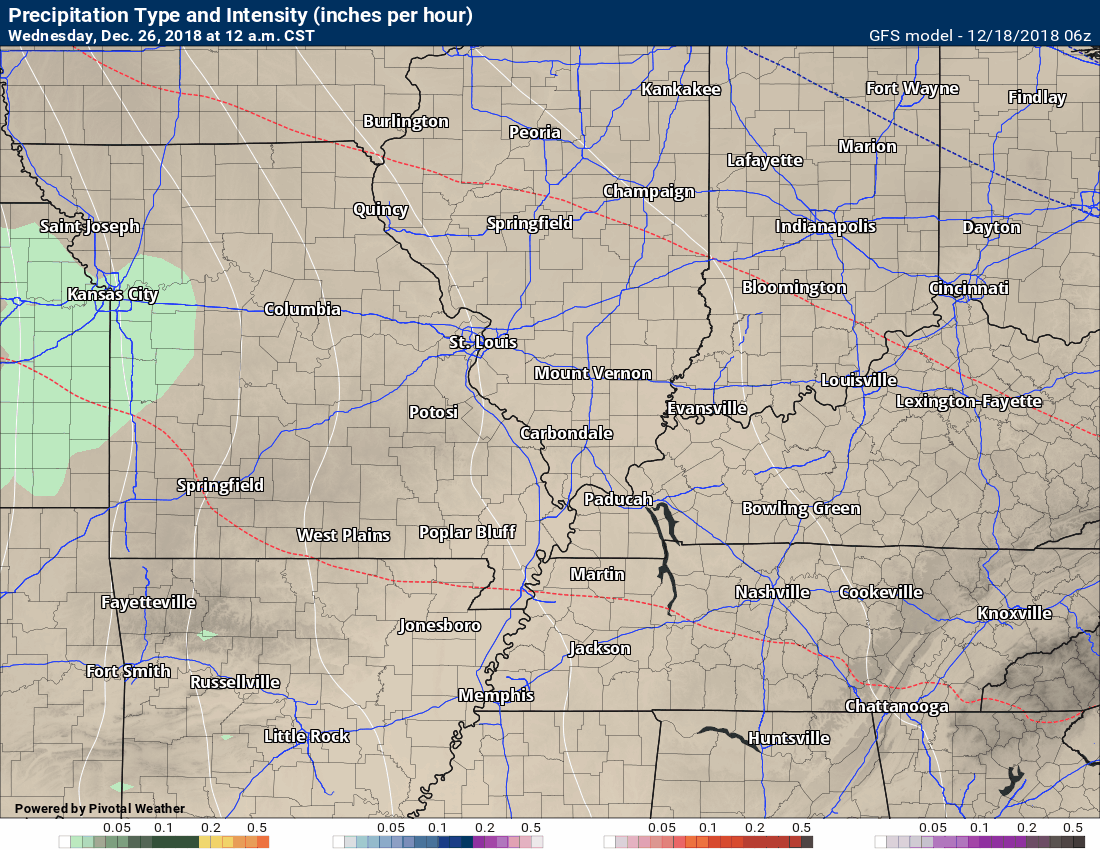
Here is the NAM model guidance through 9 AM Friday morning. You can see that some showers move into the region as early as Wednesday night.
Green represents rain. Blue is snow.
The time-stamp is located in the upper left portion of the model animation.
Notice the blue at the very end? That is when the rain may mix with snow. For now, this risk doesn’t appear to be anything to worry about.
Road temperatures would be too warm, as well (for impacts).
As always, monitor updates.
Here is the GFS model guidance future-cast radar. NAM is one model. GFS is another model.
This one goes out through Friday evening. Green is rain. Blue is snow.
The time-stamp is located in the upper left portion of the model animation.
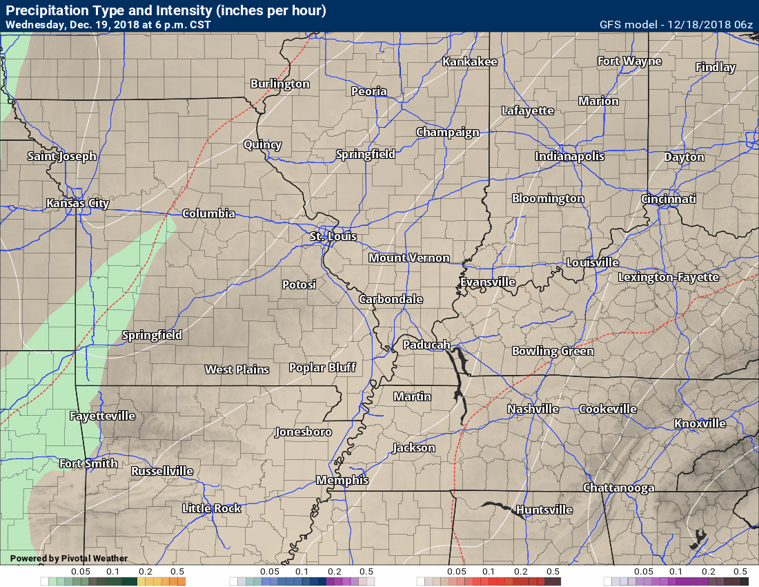
Friday afternoon into Tuesday should be dry.
I am monitoring a weak system that shows up on the EC model guidance. The EC model attempts to spit out some light showers Monday night into Tuesday night.
You can see that here.
I do have low-end rain chances during that time-frame.
Not all guidance agrees on this. I will leave the chances low and update moving forward.
It does appear that it would be too warm for snow or ice. Again, as always, monitor updates.
EC model guidance for next Tuesdasy. You can see some light precip showing up. Low confidence.
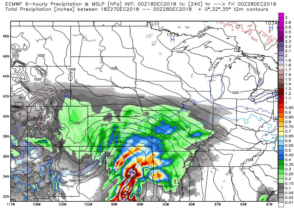
Another larger precipitation event is forecast to take shape by late Wednesday night into Friday.
The GFS actually keeps an extended period of precipitation going into Saturday. Confidence on it lasting into next Saturday is low.
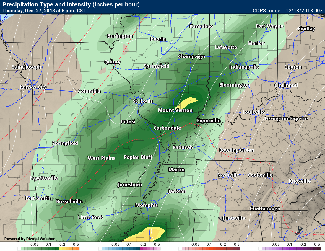
Confidence in another rain event next Thursday, December 27th is higher.
We could even have thunderstorms. Some of the model guidance pushes the low to our north. That places us on the warm side of the rain event. Let’s keep an eye on it.
Either way, it does appear that more rain is likely as we move past Christmas Day.
Rainfall totals could be locally heavy if some of the guidance is correct.
The time-stamp is located in the upper left portion of the model animation.
GFS model.
Green is rain. Yellow is heavier rain. Blue is snow. Pink is ice.
This event has support from other model guidance,as well.
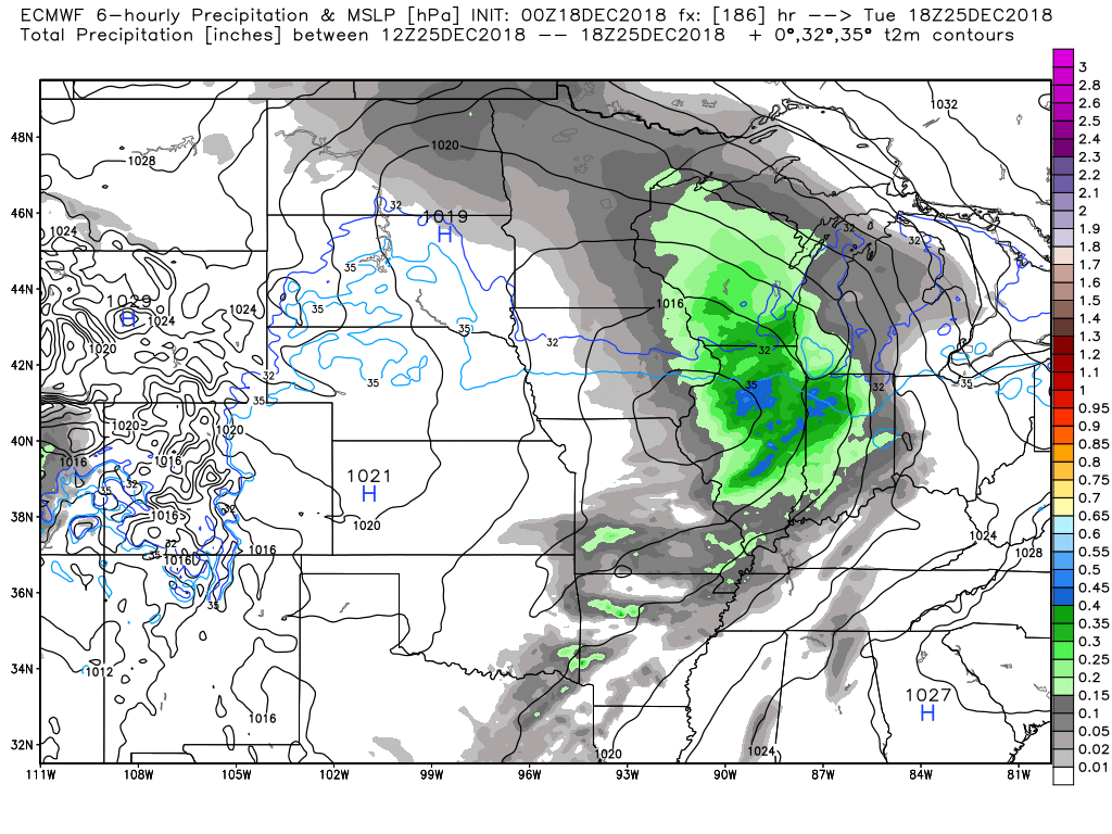
Here is the EC model. It shows rain moving back into our region next Thursday.
On this particular map, the bright colors represent six-hour rain totals.
This map does not show you snow or ice.
The EC model shows heavy rain to our southwest. That would push into our region, as well.
The Canadian model also shows this event. It also shows an all rain event.
At this time, I am not tracking any snowstorms.
There are signals for colder weather as we push into early January.
I am not a huge fan of long-range forecasts. Let’s keep an eye on it. I know some of you want snow.
The forecast was for a colder and stormier winter. Certainly, the stormier is ongoing and has been since November. November brought record cold. December, thus far, has delivered a mix of above and below normal temperatures.
![]()

I bring these to you from the BAMwx team. They are excellent long-range forecasters.
Remember, long-range outlooks are a bit of skill, understanding weather patterns, and luck combined. It is not an exact science.

This product is for subscribers.
Subscribe at www.weathertalk.com
Subscriber graphics can be viewed on this page CLICK HERE

This product is for subscribers.

This product is for subscribers.
Subscribe at www.weathertalk.com
Subscriber graphics can be viewed on this page CLICK HERE
![]()
.
Winter Outlook!
These products are for subscribers.
December temperature and precipitation outlook
January temperature outlook
February temperature outlook
Winter snow outlook
.These products are for subscribers.
![]()

A new weather podcast is now available! Weather Geeks (which you might remember is on The Weather Channel each Sunday)
To learn more visit their website. Click here.
![]()

WeatherBrains Episode 670
Tonight’s Guest WeatherBrain is the former Meteorologist-in-charge of the National Weather Service in Mount Holly, New Jersey. Gary Szatkowski, welcome to WeatherBrains!
Other discussions in this weekly podcast include topics like:
- The difficulty of precipitation-type winter forecasting
- Snowmageddon-type event in New York similar to Atlanta/Birmingham event of 2014
- Figuring out social media as a meteorologist
- Astronomy Outlook with Tony Rice
- and more!
Link to their website https://weatherbrains.com/
Previous episodes can be viewed by clicking here.

We offer interactive local city live radars and regional radars. If a radar does not update then try another one. If a radar does not appear to be refreshing then hit Ctrl F5. You may also try restarting your browser.
The local city view radars also have clickable warnings.
During the winter months, you can track snow and ice by clicking the winterize button on the local city view interactive radars.
You may email me at beaudodson@usawx.com
Find me on Facebook!

Find me on Twitter!

Did you know that a portion of your monthly subscription helps support local charity projects?
You can learn more about those projects by visiting the Shadow Angel Foundation website and the Beau Dodson News website.

I encourage subscribers to use the app vs regular text messaging. We have found text messaging to be delayed during severe weather. The app typically will receive the messages instantly. I recommend people have three to four methods of receiving their severe weather information.
Remember, my app and text alerts are hand typed and not computer generated. You are being given personal attention during significant weather events.
