
.
Your daily forecast into the coming weekend.
Saturday Night Forecast Details:
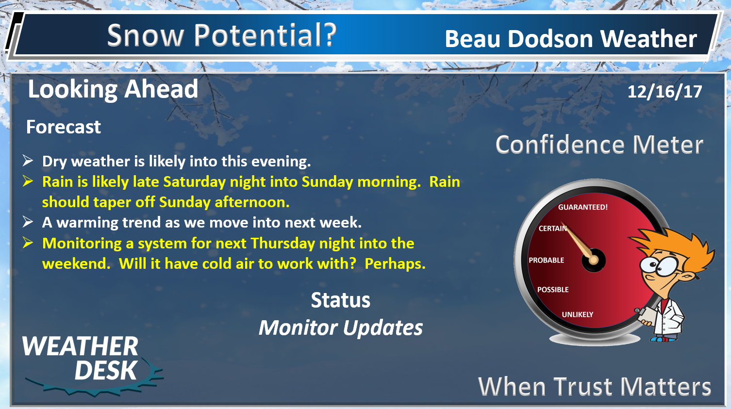
Forecast: Becoming cloudy. Dry this evening. Showers increasing from the south and west late tonight. The greatest chance of rain will be after 2 AM.
Temperatures: MO ~ 35 to 40 IL ~ 35 to 40 KY ~ 35 to 40
Wind chill values: 30 to 40
Accumulating snow or ice: No
Winds: South and southwest winds 6 to 12 mph with gusts to 20 mph
What impacts are anticipated from the weather? Wet roadways
My confidence in the forecast verifying: High
Is severe weather expected? No
The NWS defines severe weather as 58 mph wind or great, 1″ hail or larger, and/or tornadoes
Is freezing rain, sleet, or snow expected? None
What is the chance of precipitation? The rain % will increase mostly after midnight MO ~ 70% IL ~ 60% KY ~ 70%
Coverage of precipitation: Increasing coverage from the south and west.
Should I cancel my outdoor plans: No
.
Interactive Weather Radar Page. Choose the city nearest your location: Click this link
.
December 17, 2017
Sunday Forecast Details
Forecast: Mostly cloudy. A period of gusty winds possible. Widespread rain is anticipated during the morning. Greatest coverage before 2 pm. Rain should decrease during the afternoon.
Temperatures: MO ~ 45 to 50 IL ~ 45 to 50 KY ~ 46 to 52
Wind chill values: N/A
Accumulating snow or ice: No
Winds: South and southwest at 6 to 12 mph with gusts to 18 mph. There is a chance of some stronger winds on Sunday, but confidence is low (on that subject).
What impacts are anticipated from the weather? Wet roadways. Maybe some gusty winds.
My confidence in the forecast verifying: High
Is severe weather expected? No
The NWS defines severe weather as 58 mph wind or great, 1″ hail or larger, and/or tornadoes
Is freezing rain, sleet, or snow expected? No
What is the chance of precipitation? MO ~ 80% IL ~ 70% KY ~ 80%
Coverage of precipitation: Widespread first half of the day with decreasing coverage as we move into the afternoon
Should I cancel my outdoor plans? Have a plan B
.
December 17, 2017
Sunday Night Forecast Details:
Forecast: Mostly cloudy. Patchy fog and drizzle.
Temperatures: MO ~ 38 to 44 IL ~ 38 to 44 KY ~ 38 to 44
Wind chill values: 30’s
Accumulating snow or ice: No
Winds: South and southwest wind at 5 to 10 mph.
What impacts are anticipated from the weather? Lower visibility in fog. Wet roadways.
My confidence in the forecast verifying: High
Is severe weather expected? No
The NWS defines severe weather as 58 mph wind or great, 1″ hail or larger, and/or tornadoes
Is freezing rain, sleet, or snow expected? None
What is the chance of precipitation? MO ~ 10% IL ~ 20% KY ~ 20%
Coverage of precipitation: Ending
Should I cancel my outdoor plans: No
.
December 18, 2017
Monday Forecast Details
Forecast: Cloudy with showers and fog possible.
Temperatures: MO ~ 55 to 60 IL ~ 54 to 58 KY ~ 55 to 60
Wind chill values: N/A
Accumulating snow or ice: No
Winds: West and southwest winds 5 to 10 mph with gusts to 20 mph
What impacts are anticipated from the weather? Lower visibility in fog. Wet roadways.
My confidence in the forecast verifying: Medium
Is severe weather expected? No
The NWS defines severe weather as 58 mph wind or great, 1″ hail or larger, and/or tornadoes
Is freezing rain, sleet, or snow expected? No
What is the chance of precipitation? MO ~ 30% IL ~ 30% KY ~ 30%
Coverage of precipitation: Isolated shower possible.
Should I cancel my outdoor plans? No
.
Monday Night Forecast Details:
Forecast: Quite a few clouds. A slight chance of light rain.
Temperatures: MO ~ 42 to 46 IL ~ 40 to 45 KY ~ 43 to 46
Wind chill values: 25 to 35
Accumulating snow or ice: No
Winds: Southwest winds at 5 to 10 mph with gusts to 15 mph
What impacts are anticipated from the weather? Most likely none, but I will monitor a slight chance of precipitation
My confidence in the forecast verifying: Medium
Is severe weather expected? No
The NWS defines severe weather as 58 mph wind or great, 1″ hail or larger, and/or tornadoes
Is freezing rain, sleet, or snow expected? None
What is the chance of precipitation? MO ~ 20% IL ~ 20% KY ~ 20%
Coverage of precipitation: None to isolated
Should I cancel my outdoor plans: No
.
December 19, 2017
Tuesday Forecast Details
Forecast: Partly cloudy. A chance of afternoon showers.
Temperatures: MO ~ 56 to 62 IL ~ 55 to 60 KY ~ 56 to 62
Wind chill values: N/A
Accumulating snow or ice: No
Winds: West and southwest 6 to 12 mph
What impacts are anticipated from the weather? Wet roadways
My confidence in the forecast verifying: LOW
Is severe weather expected? No
The NWS defines severe weather as 58 mph wind or great, 1″ hail or larger, and/or tornadoes
Is freezing rain, sleet, or snow expected? No
What is the chance of precipitation? MO ~ 30% IL ~ 20% KY ~ 30%
Coverage of precipitation: Isolated
Should I cancel my outdoor plans? No
.
Tuesday Night Forecast Details:
Forecast: Partly cloudy. A shower possible.
Temperatures: MO ~ 36 to 44 IL ~ 36 to 44 KY ~ 40 to 45
Wind chill values: 30’s
Accumulating snow or ice: No
Winds: North and northeast winds at 5 to 10 mph
What impacts are anticipated from the weather? Perhaps wet roadways
My confidence in the forecast verifying: LOW
Is severe weather expected? No
The NWS defines severe weather as 58 mph wind or great, 1″ hail or larger, and/or tornadoes
Is freezing rain, sleet, or snow expected? None
What is the chance of precipitation? MO ~ 40% IL ~ 40% KY ~ 40%
Coverage of precipitation: Scattered
Should I cancel my outdoor plans: No
.
December 20, 2017
Wednesday Forecast Details
Forecast: Increasing clouds. Showers possible.
Temperatures: MO ~ 50 to 55 IL ~ 50 to 55 KY ~ 50 to 55
Wind chill values: N/A
Accumulating snow or ice: No
Winds: Northwest 5 to 10 mph with gusts to 12 mph
What impacts are anticipated from the weather? Wet roadways
My confidence in the forecast verifying: Medium
Is severe weather expected? No
The NWS defines severe weather as 58 mph wind or great, 1″ hail or larger, and/or tornadoes
Is freezing rain, sleet, or snow expected? No
What is the chance of precipitation? MO ~ 30% IL ~ 30% KY ~ 30%
Coverage of precipitation: Isolated to perhaps scattered.
Should I cancel my outdoor plans? Monitor updates
.
Wednesday Night Forecast Details:
Forecast: Mostly cloudy.
Temperatures: MO ~ 34 to 38 IL ~ 34 to 38 KY ~ 34 to 38
Wind chill values: 25 to 35
Accumulating snow or ice: No
Winds: East and southeast winds at 5 to 10 mph
What impacts are anticipated from the weather? Most likely none
My confidence in the forecast verifying: Medium
Is severe weather expected? No
The NWS defines severe weather as 58 mph wind or great, 1″ hail or larger, and/or tornadoes
Is freezing rain, sleet, or snow expected? None
What is the chance of precipitation? MO ~ 10% IL ~ 10% KY ~ 20%
Coverage of precipitation: Most likely none
Should I cancel my outdoor plans: No
.
December 21, 2017
Thursday Forecast Details
Forecast: Mostly sunny with a few passing clouds.
Temperatures: MO ~ 53 to 56 IL ~ 54 to 56 KY ~ 54 to 58
Wind chill values: N/A
Accumulating snow or ice: No
Winds: South winds at 5 to 10 mph
What impacts are anticipated from the weather? None
My confidence in the forecast verifying: Medium
Is severe weather expected? No
The NWS defines severe weather as 58 mph wind or great, 1″ hail or larger, and/or tornadoes
Is freezing rain, sleet, or snow expected? No
What is the chance of precipitation? MO ~ 0% IL ~ 0% KY ~ 0%
Coverage of precipitation: None
Should I cancel my outdoor plans? No
.
Thursday Night Forecast Details:
Forecast: Increasing clouds. A chance of late night showers.
Temperatures: MO ~ 33 to 36 IL ~ 32 to 35 KY ~ 33 to 36
Wind chill values: 28 to 34
Accumulating snow or ice: Most likely no
Winds: South and southwest winds at 5 to 10 mph
What impacts are anticipated from the weather? Perhaps wet roadways
My confidence in the forecast verifying: LOW
Is severe weather expected? No
The NWS defines severe weather as 58 mph wind or great, 1″ hail or larger, and/or tornadoes
Is freezing rain, sleet, or snow expected? Monitor updates
What is the chance of precipitation? MO ~ 30% IL ~ 30% KY ~ 20%
Coverage of precipitation: Scattered
Should I cancel my outdoor plans: No
.
December 22, 2017
Friday Forecast Details
Forecast: Mostly cloudy. A chance of showers.
Temperatures: MO ~ 45 to 50 IL ~ 45 to 50 KY ~ 45 to 50
Wind chill values: N/A
Accumulating snow or ice: Monitor updates
Winds:
What impacts are anticipated from the weather?
My confidence in the forecast verifying: LOW
Is severe weather expected? No
The NWS defines severe weather as 58 mph wind or great, 1″ hail or larger, and/or tornadoes
Is freezing rain, sleet, or snow expected? No
What is the chance of precipitation? MO ~ 40% IL ~ 40% KY ~ 40%
Coverage of precipitation: Scattered
Should I cancel my outdoor plans? Monitor updates
.
Friday Night Forecast Details:
Forecast: Mostly cloudy. Rain or snow showers possible.
Temperatures: MO ~ 33 to 36 IL ~ 32 to 35 KY ~ 33 to 36
Wind chill values: 28 to 34
Accumulating snow or ice: Monitor updates
Winds: Northwest 6 to 12 mph
What impacts are anticipated from the weather?
My confidence in the forecast verifying: LOW
Is severe weather expected? No
The NWS defines severe weather as 58 mph wind or great, 1″ hail or larger, and/or tornadoes
Is freezing rain, sleet, or snow expected? Monitor updates
What is the chance of precipitation? MO ~ 30% IL ~ 30% KY ~ -30%
Coverage of precipitation: Scattered
Should I cancel my outdoor plans: Monitor updates
.

.
Sunday night through next Thursday: The risk for freezing rain, sleet, and snow is near zero.
I am monitoring next Friday into Christmas week. A few systems could bring wintry weather to the region. Low confidence (too far out).
.

The National Weather Service definition of a severe thunderstorm is one that produces quarter size hail or larger, 58 mph winds or greater, and/or a tornado.
Sunday through next Thursday: No severe weather.
.

.
December 16, 2017
Forecast
Interactive Weather Radar Page. Choose the city nearest your location: Click this link
Rain will overspread the region tonight. The rain will move in from the south/southwest and spread north/northeast.
This is a light rain event. The greatest coverage of precipitation will be between 12 AM Sunday and 1 PM Sunday.
Here is my latest rainfall totals forecast.
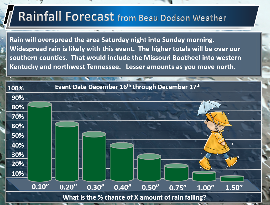
We could use some rain. Drought conditions blanket portions of the region.
Dry weather is anticipated for Monday and Tuesday.
A storm system will approach our region from the south on Wednesday. Confidence on the exact track of this system is rather low.
I do believe clouds and some showers will spread into at least the Missouri Bootheel and Kentucky/Tennessee border counties.
Whether the rain moves north of there is the question. For now, I have low end rain chances on Wednesday.
A winter storm is forecast to develop on Friday and Saturday across portions of Texas. Model guidance indicates that the system may spread precipitation northeastward into Arkansas and the Tennessee Valley.
Model guidance past a couple of days is not accurate during the winter months. Forecasters have a hard time forecasting snow and ice a day in advance, let alone a week in advance. Be leery of any graphics showing you how much snow or ice might fall. There isn’t even a guarantee that there will be precipitation.
Once again, the track of this system remains questionable, at best.
The GFS shows a large snow and ice storm from Texas into our region. Meanwhile, the EC guidance shows dry weather Friday through Monday.
The GFS model ensembles are 50/50. Fifty percent of them showing snow and fifty percent are showing no snow.
Only 10 out of 51 EC ensembles show accumulating snow or ice in our region.
The model guidance literally ranges from dry weather to rain to a snow storm to an ice storm. Thus, no confidence is given in the long range forecast.
My snow/ice numbers remain mostly unchanged.
Beau’s Winter Weather Outlook
It is important to remember that this pattern is fluid. There is always going to be lower than normal confidence, during the winter months, for the forecast past day three or four.
.
.
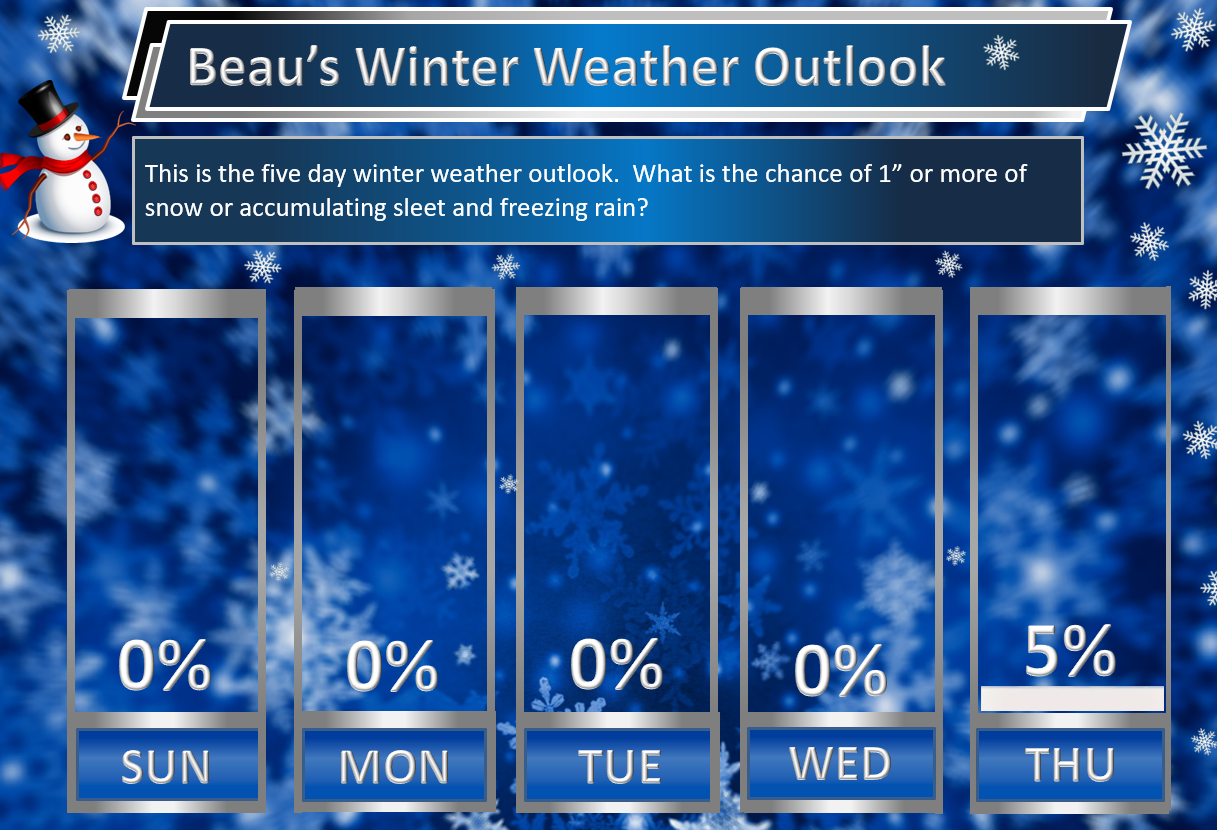
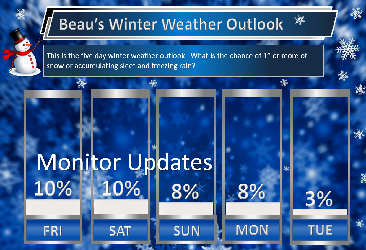
Here are my latest snow probability maps for the week ahead.
These graphics show you the % chance of one inch or more of snow and/or accumulating sleet and freezing rain.
In tomorrow’s update I will likely remove the Thursday five percent.
.
.
We need to monitor late next week into Christmas week. Model guidance shows a very active pattern that could mean multiple precipitation events.
Monitor updates moving forward. Confidence is low (it is in the long range).
If we end up on the warm side of the boundary then precipitation type would be rain. Too soon to know the answer to that question. Too soon to even know if there will be precipitation.
Keep in mind, I rarely go above 10% chances past day five. That means 10% is a max number for days six through ten.
.
.
There is an above normal risk for a storm system(s) between December 22nd and December 28th.
.


We offer regional radars and local city radars – if a radar does not update then try another one. Occasional browsers need their cache cleared. You may also try restarting your browser. This will usually fix any problems.
During the winter you can track snow and ice by clicking the winterize button on the local city view interactive radars.
You may email me at beaudodson@usawx.com
Interactive Weather Radar Page. Choose the city nearest your location: Click this link
National interactive radar: Click this link.