WeatherTalk monthly operating costs can top $2000.00. Your $5 subscription helps pay for those costs. I work for you.
The $5 will allow you to register up to seven phones!
For $5 a month you can receive the following. You may choose to receive these via your WeatherTalk app or regular text messaging.
- Severe weather app/text alerts from my keyboard to your app/cell phone. These are hand typed by Beau. During tornado outbreaks, you will receive numerous app/text messages telling you exactly where the tornado is located.
- Daily forecast app/texts from my computer to your app/cell phone.
- Social media links sent directly to your app/cell phone. When I update the blog, videos, or Facebook you will receive the link.
- AWARE emails. These emails keep you well ahead of the storm. They give you several days of lead time before significant weather events.
- Direct access to Beau via text and email. Your very own personal meteorologist. I work for you!
- Missouri and Ohio Valley centered video updates
- Long-range weather videos
- Week one, two, three and four temperature and precipitation outlooks.
- Monthly outlooks.
- Your subscription also will help support several local charities.
Would you like to subscribe? Subscribe at www.beaudodsonweather.com

I encourage subscribers to use the app vs regular text messaging. We have found text messaging to be delayed during severe weather. The app typically will receive the messages instantly. I recommend people have three to four methods of receiving their severe weather information.
Remember, my app and text alerts are hand typed and not computer generated. You are being given my personal attention during significant weather events.

WWW.WEATHERTALK.COM subscribers, here is my day to day schedule for your weather products.


We offer interactive local city live radars and regional radars. If a radar does not update then try another one. If a radar does not appear to be refreshing then hit Ctrl F5. You may also try restarting your browser.

August 6, 2018
Monday Forecast Details
Forecast: A mix of sun and clouds. A few scattered showers and thunderstorms possible. Odds favor most of us remaining dry. A few spots could pick up some rain. Hot and muggy. Heat index values in the upper 90’s to lower 100’s.
Temperatures: MO ~ 90 to 95 IL ~ 90 to 94 KY ~ 90 to 94 TN ~ 90 to 94 Heat index values of 98 to 104
What is the chance of precipitation? MO ~ 20% IL ~ 20% KY ~ 10% to 20% TN ~ 10%
Coverage of precipitation: Isolated
Wind: South at 5 to 10 mph with gusts to 14
What impacts are anticipated from the weather? Isolated wet roads. Lightning.
My confidence in the forecast verifying: High
Is severe weather expected? Summer storms can produce pockets of high winds
The NWS defines severe weather as 58 mph wind or great, 1″ hail or larger, and/or tornadoes
Should I cancel my outdoor plans? No, but check radars
UV Index: 9 to 10 High
Sunrise: 6:04 AM
Monday Night Forecast Details:
Forecast: Partly cloudy. Widely scattered showers and thunderstorms. Warm and humid.
Temperatures: MO ~ 70 to 74 IL ~ 70 to 74 KY ~ 70 to 74 TN ~ 70 to 74
What is the chance of precipitation? MO ~ 40% IL ~ 30% KY ~ 20% to 30% TN ~ 20% to 30%
Coverage of precipitation: Widely scattered (best chance over southeast Missouri)
Wind: South and southwest at 6 to 12 mph
What impacts are anticipated from the weather? Wet roadways. Lightning.
My confidence in the forecast verifying: High
Is severe weather expected? Summer storms can produce pockets of high winds
The NWS defines severe weather as 58 mph wind or great, 1″ hail or larger, and/or tornadoes
Should I cancel my outdoor plans? No, but check radars
Sunset: 7:57 PM
Moonrise: 1:12 AM Waning crescent
Moonset: 3:29 PM
.
August 7, 2018
Tuesday Forecast Details
Forecast: Partly to mostly cloudy. Warm and humid. Increasing chances of showers and thunderstorms. Some could produce heavy rain.
Temperatures: MO ~ 84 to 88 IL ~ 84 to 88 KY ~ 86 to 90 TN ~ 86 to 90
What is the chance of precipitation? MO ~ 50%-60% IL ~ 40%-50% KY ~ 40%-50% TN ~ 40%-50%
Coverage of precipitation: Scattered to numerous
Wind: West and southwest wind at 6 to 12 mph with gusts to 16
What impacts are anticipated from the weather? Wet roads. Lightning. Locally heavy rain. A few storms could produce strong and gusty winds.
My confidence in the forecast verifying: Medium
Is severe weather expected? A few strong storms are possible. Monitor updates.
The NWS defines severe weather as 58 mph wind or great, 1″ hail or larger, and/or tornadoes
Should I cancel my outdoor plans? Check radars. Showers and storms are certainly possible
UV Index: 4 to 7 Medium (clouds will help keep the index lower)
Sunrise: 6:04 AM
We offer interactive local city live radars and regional radars. If a radar does not update then try another one
Tuesday Night Forecast Details:
Forecast: Cloudy with scattered showers and thunderstorms. Locally heavy rain possible where thunderstorms occur.
Temperatures: MO ~ 66 to 72 IL ~ 66 to 72 KY ~ 70 to 74 TN ~ 70 to 74
What is the chance of precipitation? MO ~ 50% to 60% IL ~ 50% to 60% KY ~ 50% to 60% TN ~ 50% to 60%
Coverage of precipitation: Scattered to numerous
Wind: West and southwest at 6 to 12 mph
What impacts are anticipated from the weather? Wet roadways. Lightning. Locally heavy rain where thunderstorms occur. Gusty wind near thunderstorms.
My confidence in the forecast verifying: Medium
Is severe weather expected? A few strong storms are possible. Monitor updates.
The NWS defines severe weather as 58 mph wind or great, 1″ hail or larger, and/or tornadoes
Should I cancel my outdoor plans? Have a plan B and check radars
Sunset: 7:56 PM
Moonrise: 1:58 AM Waning crescent
Moonset: 4:36 PM
August 8, 2018
Wednesday Forecast Details
Forecast: Mostly cloudy. Scattered showers and thunderstorms. Locally heavy downpours where thunderstorms develop.
Temperatures: MO ~ 84 to 88 IL ~ 84 to 88 KY ~ 84 to 88 TN ~ 84 to 88
What is the chance of precipitation? MO ~ 40%-50% IL ~ 40%-50% KY ~ 50%-60% TN ~ 50%-60%
Coverage of precipitation: Scattered to numerous
Wind: West and southwest at 5 to 10 mph with gusts to 15 mph.
What impacts are anticipated from the weather? Wet roads. Lightning. Locally heavy rain where storms occur. Gusty wind near thunderstorms
My confidence in the forecast verifying: Medium
Is severe weather expected? Unlikely, but monitor updates. If the front remains in the region then a few strong storms will be possible.
The NWS defines severe weather as 58 mph wind or great, 1″ hail or larger, and/or tornadoes
Should I cancel my outdoor plans? Check radars. Showers and storms are a possibility
UV Index: 8 to 10 High
Sunrise: 6:05 AM
Wednesday Night Forecast Details:
Forecast: Partly cloudy with widely scattered showers and thunderstorms in west Kentucky and west Tennessee. A few storms possible in southeast Missouri and southern Illinois, as well. The bulk of the chances will be before 10 pm.
Temperatures: MO ~ 66 to 68 IL ~ 66 to 68 KY ~ 66 to 70 TN ~ 66 to 70
What is the chance of precipitation? MO ~ 20% IL ~ 20% KY ~ 30% TN ~ 40%
Coverage of precipitation: Isolated to widely scattered (esp KY/TN)
Wind: West and northwest at 6 to 12 mph
What impacts are anticipated from the weather? Widely scattered wet roadways. Lightning. Gusty wind near thunderstorms
My confidence in the forecast verifying: High
Is severe weather expected? Unlikely
The NWS defines severe weather as 58 mph wind or great, 1″ hail or larger, and/or tornadoes
Should I cancel my outdoor plans? No, but glance at radars
Sunset: 7:54 PM
Moonrise: 2:52 AM Waning crescent
Moonset: 7:54 PM
August 9, 2018
Thursday Forecast Details
Forecast: A mix of sun and clouds. Warm. Widely scattered thunderstorms.
Temperatures: MO ~ 85 to 88 IL ~ 85 to 88 KY ~ 85 to 88 TN ~ 85 to 88
What is the chance of precipitation? MO ~ 20% IL ~ 20% KY ~ 30% to 40% TN ~ 30% to 40%
Coverage of precipitation: Widely scattered
Wind: Variable at 4 to 8 mph
What impacts are anticipated from the weather? Wet roads and lightning. Gusty wind near thunderstorms
My confidence in the forecast verifying: Medium
Is severe weather expected? Summer storms can produce isolated high winds
The NWS defines severe weather as 58 mph wind or great, 1″ hail or larger, and/or tornadoes
Should I cancel my outdoor plans? No, but glance at radar
UV Index: 6 to 8 Moderate to high
Sunrise: 6:06 AM
Thursday Night Forecast Details:
Forecast: Partly cloudy. A few evening thunderstorms.
Temperatures: MO ~ 66 to 68 IL ~ 66 to 68 KY ~ 66 to 68 TN ~ 66 to 68
What is the chance of precipitation? MO ~ 20% IL ~ 20% KY ~ 20% TN ~ 20%
Coverage of precipitation: Isolated
Wind: Variable at 4 to 8 mph
What impacts are anticipated from the weather? A few wet roads and lightning. Gusty wind near thunderstorms
My confidence in the forecast verifying: Medium
Is severe weather expected? Summer storms can occasionally produce isolated high winds
The NWS defines severe weather as 58 mph wind or great, 1″ hail or larger, and/or tornadoes
Should I cancel my outdoor plans? No, but glance at radars
Sunset: 7:53 PM
Moonrise: 3:54 AM Waning crescent
Moonset: 6:40 PM
August 10, 2018
Friday Forecast Details
Forecast: A mix of sun and clouds. Isolated to widely scattered thunderstorms. Warm.
Temperatures: MO ~ 86 to 90 IL ~ 86 to 88 KY ~ 85 to 88 TN ~ 85 to 88
What is the chance of precipitation? MO ~ 30% IL ~ 20% to 30% KY ~ 30% TN ~ 30%
Coverage of precipitation: Widely scattered
Wind: Northeast at 4 to 8 mph
What impacts are anticipated from the weather? Wet roadways and lightning. Gusty wind near thunderstorms
My confidence in the forecast verifying: LOW
Is severe weather expected? Summer storms can produce isolated high winds
The NWS defines severe weather as 58 mph wind or great, 1″ hail or larger, and/or tornadoes
Should I cancel my outdoor plans? No, but glance at radar
UV Index: 8 to 10 High
Sunrise: 6:07 AM
Friday Night Forecast Details:
Forecast: A few clouds. An isolated thunderstorm possible (mainly early)
Temperatures: MO ~ 66 to 70 IL ~ 66 to 68 KY ~ 66 to 70 TN ~ 66 to 72
What is the chance of precipitation? MO ~ 20% IL ~ 20% KY ~ 30% TN ~ 30%
Coverage of precipitation: Isolated to widely scattered
Wind: Northeast and east at 6 to 12 mph
What impacts are anticipated from the weather? Wet roadways and lightning. Gusty wind near thunderstorms
My confidence in the forecast verifying: LOW
Is severe weather expected? Summer storms can occasionally produce isolated high winds
The NWS defines severe weather as 58 mph wind or great, 1″ hail or larger, and/or tornadoes
Should I cancel my outdoor plans? No, but glance at radars
Sunset: 7:52 PM
Moonrise: 5:02 AM Waning crescent
Moonset: 7:33 PM
August 11, 2018
Saturday Forecast Details
Forecast: Partly to mostly sunny. Some cumulus clouds. Warm. Widely scattered thunderstorms are possible.
Temperatures: MO ~ 85 to 88 IL ~ 85 to 88 KY ~ 85 to 88 TN ~ 85 to 88
What is the chance of precipitation? MO ~ 20% IL ~ 20% KY ~ 30% TN ~ 30%
Coverage of precipitation: Isolated to widely scattered
Wind: East and southeast at 4 to 8 mph
What impacts are anticipated from the weather? Wet roadways and lightning. Gusty wind near thunderstorms
My confidence in the forecast verifying: LOW
Is severe weather expected? Summer storms can occasionally produce isolated high winds
The NWS defines severe weather as 58 mph wind or great, 1″ hail or larger, and/or tornadoes
Should I cancel my outdoor plans? No
UV Index: 8 to 10 High
Sunrise: 6:08 AM
Saturday Night Forecast Details:
Forecast: Mostly clear and warm.
Temperatures: MO ~ 64 to 68 IL ~64 to 68 KY ~ 64 to 68 TN ~ 64 to 68
What is the chance of precipitation? MO ~ 20% IL ~ 20% KY ~ 20% TN ~ 20%
Coverage of precipitation: Isolated
Wind: Light winds
What impacts are anticipated from the weather? Isolated wet roadways and lightning. Gusty wind near thunderstorms
My confidence in the forecast verifying: LOW
Is severe weather expected? Summer storms can occasionally produce isolated high winds
The NWS defines severe weather as 58 mph wind or great, 1″ hail or larger, and/or tornadoes
Should I cancel my outdoor plans? No
Sunset: 7:51 PM
Moonrise: 6:14 AM New Moon
Moonset: 8:21 PM
August 12, 2018
Sunday Forecast Details
Forecast: Mostly sunny. Some cumulus clouds. Warm. An isolated thunderstorm possible.
Temperatures: MO ~ 84 to 88 IL ~ 84 to 88 KY ~ 84 to 88 TN ~ 84 to 88
What is the chance of precipitation? MO ~ 10% to 20% IL ~ 10% to 20% KY ~ 10% to 20% TN ~ 10% to 20%
Coverage of precipitation: None to isolated
Wind: East and southeast at 4 to 8 mph
What impacts are anticipated from the weather? Perhaps some wet roadways. Lightning. Gusty wind near thunderstorms.
My confidence in the forecast verifying: Medium
Is severe weather expected? Summer storms can occasionally produce isolated high winds
The NWS defines severe weather as 58 mph wind or great, 1″ hail or larger, and/or tornadoes
Should I cancel my outdoor plans? No
UV Index: 8 to 10 High
Sunrise: 6:09 AM
Sunday Night Forecast Details:
Forecast: Mostly clear and warm. An isolated evening thunderstorm is possible.
Temperatures: MO ~ 66 to 70 IL ~66 to 70 KY ~ 66 to 70 TN ~ 66 to 70
What is the chance of precipitation? MO ~ 10% IL ~ 10% KY ~ 10% TN ~ 10%
Coverage of precipitation: Isolated
Wind: Light winds
What impacts are anticipated from the weather? Isolated wet roads. Lightning.
My confidence in the forecast verifying: Medium
Is severe weather expected? Summer storms can occasionally produce isolated high winds
The NWS defines severe weather as 58 mph wind or great, 1″ hail or larger, and/or tornadoes
Should I cancel my outdoor plans? No
Sunset: 7:50 PM
Moonrise: 7:27 AM New Moon
Moonset: 9:02 PM
Learn more about the UV index readings. Click here.

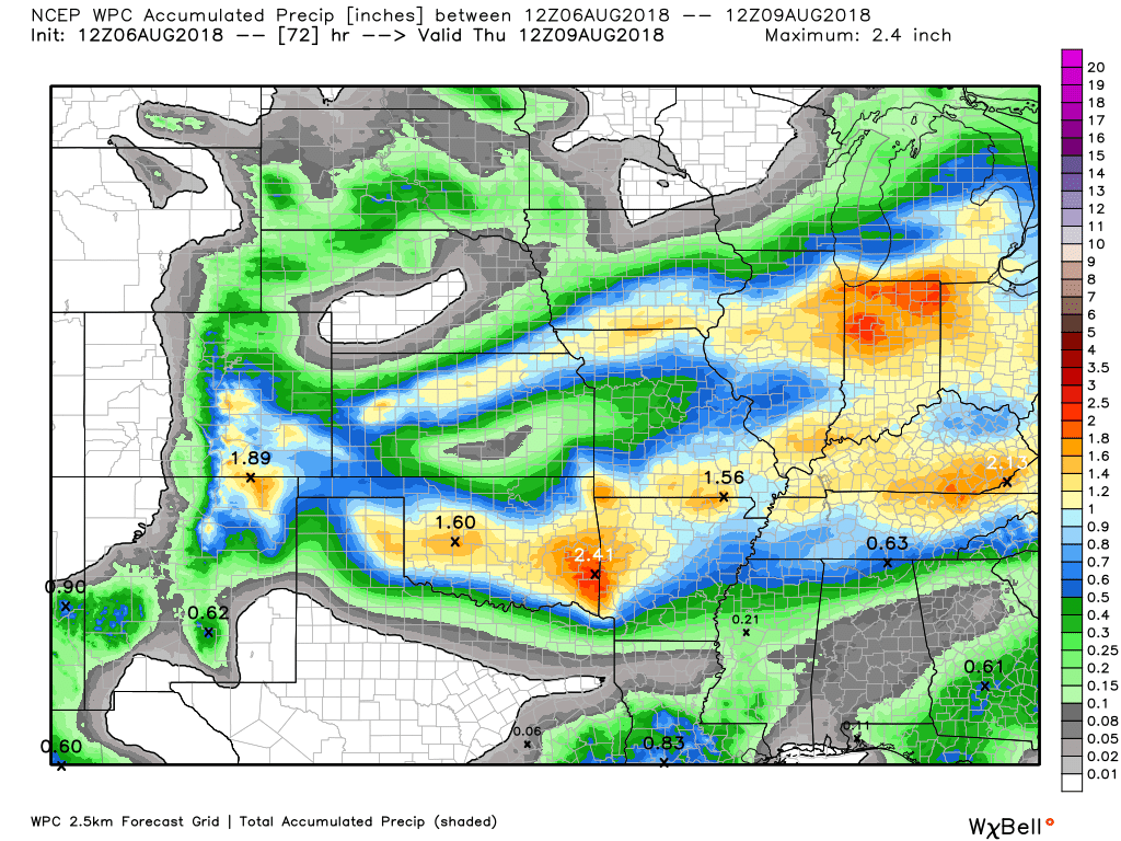
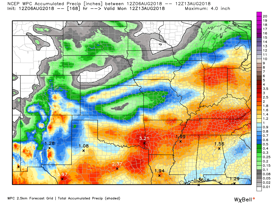
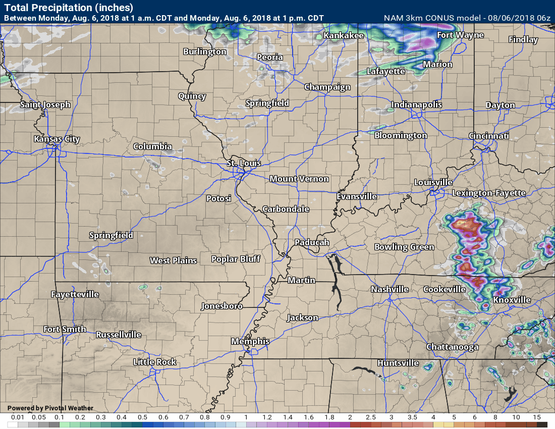
Here is the latest WPC / NOAA Rainfall charts
This graphic will not cover those wild swings in rainfall totals that occur from locally heavy thunderstorms. These number will be greatly underdone where slow moving thunderstorms occur.
This first graphic is through Thursday 7 AM
This next graphic is through 7 AM Monday, August 13th
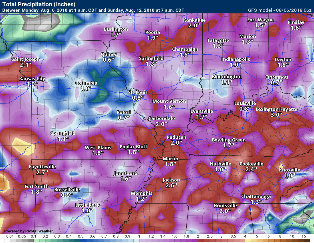
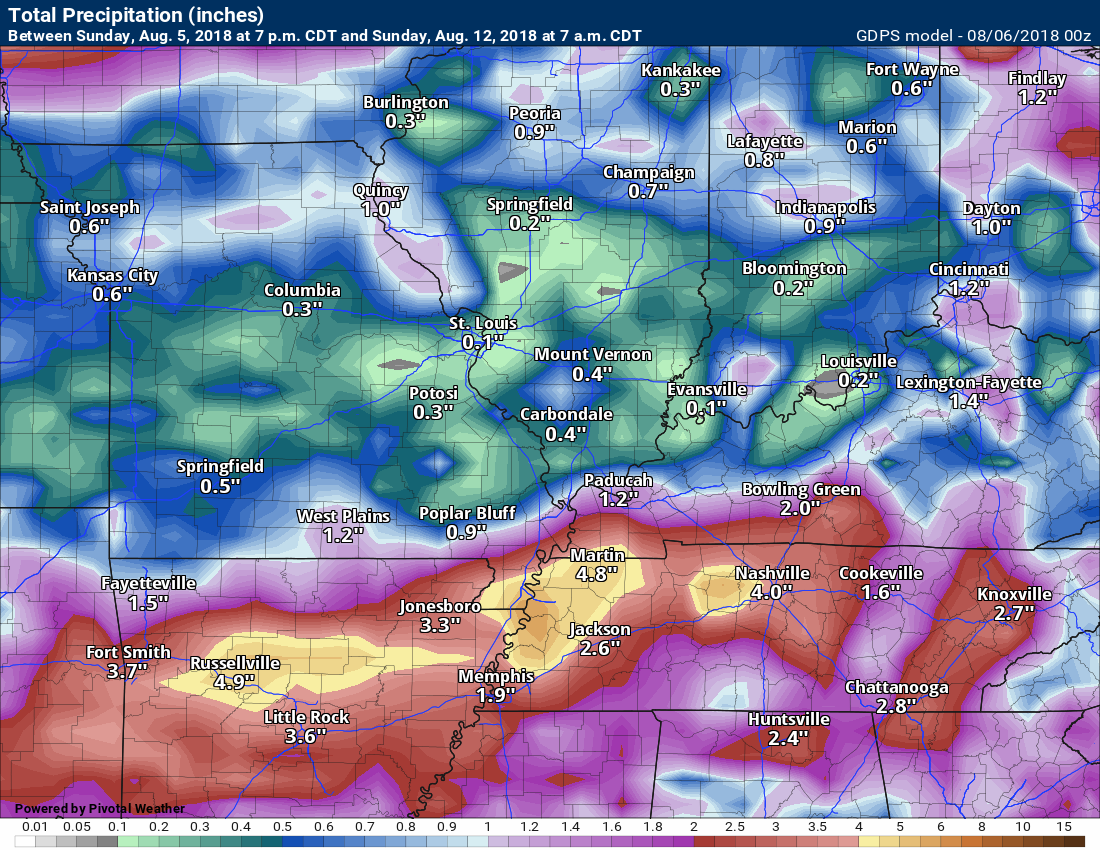
The GFS model is also showing decent rain totals for our region (this is through Sunday 7 AM)
Keep in mind, this is a model. Models are never exact. I am just showing you what the model is spitting out for rain totals.
Here is the Canadian model rain totals through 7 AM Sunday
Let’s take a look at the NAM rainfall animation.
Notice how it is patchy. That is because it is tracking thunderstorms through the region.
Again, keep in mind, this is simply a model. It won’t be exact. Take the general idea that shower and thunderstorm activity will increase over the new few days. Some heavy rain possible.
Click to enlarge
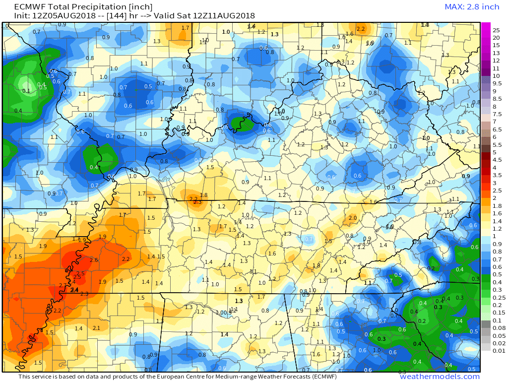
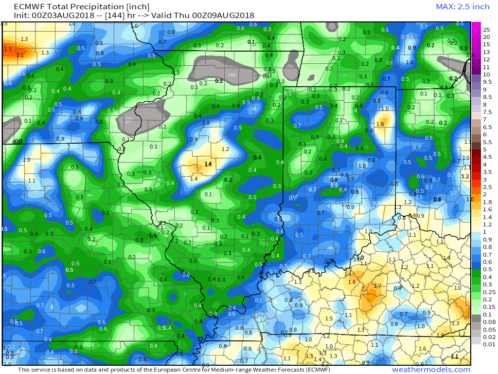
Here is the EC model guidance through Saturday morning
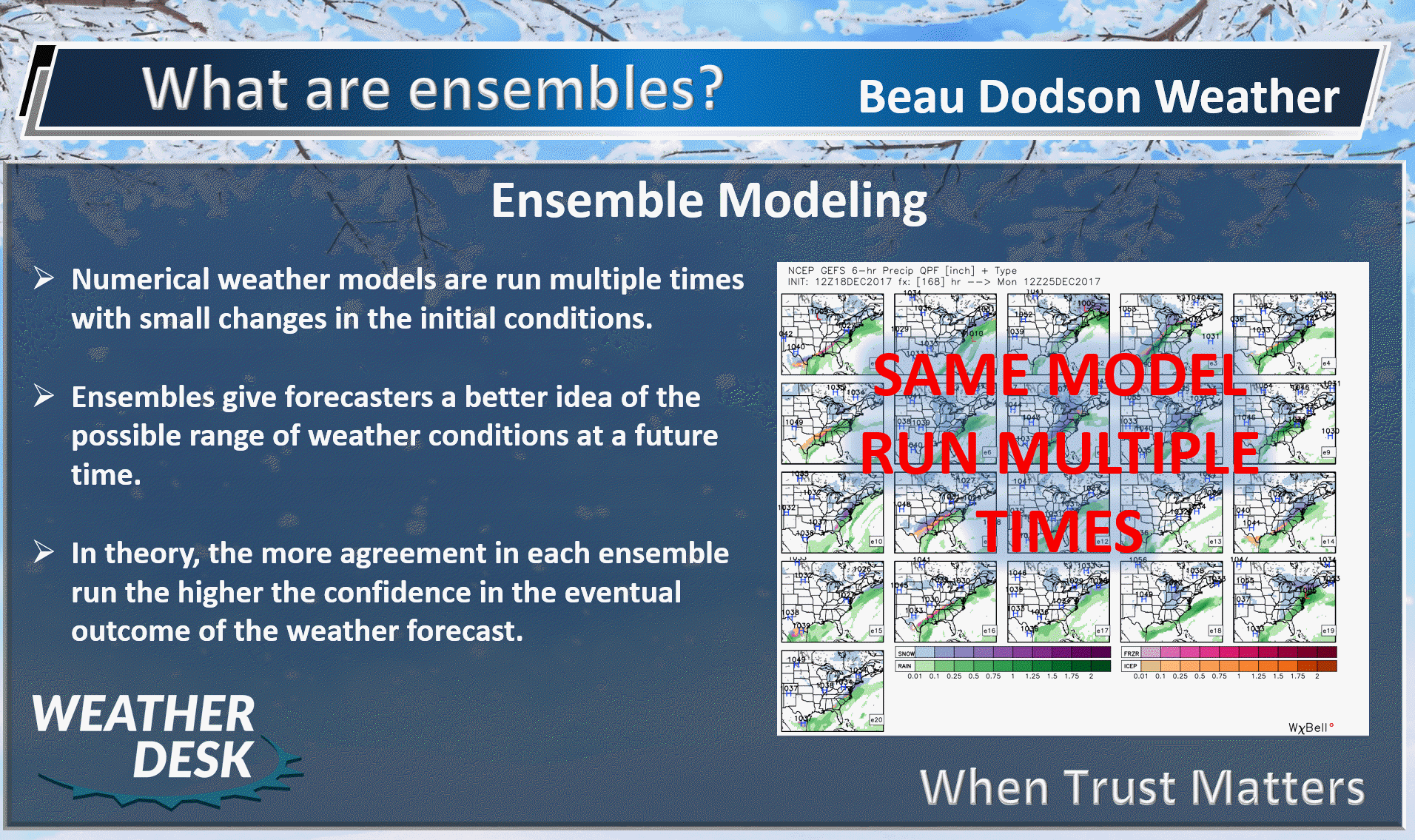
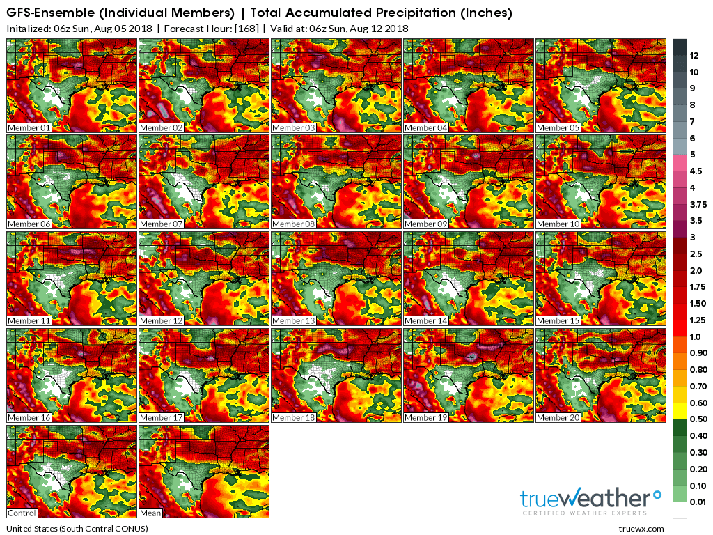
Ensembles
What are ensembles?
I usually bring this graphic out during the winter months.
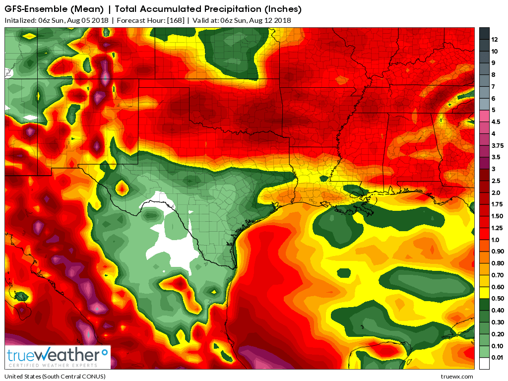
The ensemble mean shows decent rainfall totals. Let’s hope this is right.
Ensembles
Click to enlarge
The more of these that agree the greater the confidence in the forecast. Many of these do agree that we will have some rain over the coming seven days.
.

We offer interactive local city live radars and regional radars. If a radar does not update then try another one.
If a radar does not appear to be refreshing then hit Ctrl F5 on your keyboard.
You may also try restarting your browser.
The local city view radars also have clickable warnings.
During the winter months, you can track snow and ice by clicking the winterize button on the local city view interactive radars.

Questions? Broken links? Other questions?
You may email me at beaudodson@usawx.com

The National Weather Service defines a severe thunderstorm as one that produces quarter size hail or larger, 58 mph winds or greater, and/or a tornado.
Monday through Wednesday: Showers and thunderstorms will be possible during this time frame. The greatest coverage of the activity may end up being Tuesday and Wednesday.
A few of the thunderstorms could produce heavy rain, frequent lightning, gusty wind, and even small hail.
There is a low end risk of severe thunderstorms Tuesday. It is during this time period that upper level winds will be a bit stronger. That could lead to a few reports of damaging wind and quarter size hail. Overall, the risk is low at any given location.
Avoid flooded roads.
Thursday through Sunday: Confidence in the forecast after Thursday does decrease. Some of the guidance indicates additional thunderstorms Friday into the weekend. This would occur as a stalled front meanders in the region. Monitor updates.
Summer thunderstorms can produce isolated microbursts.
microburst winds can exceed 50 mph.
What are microbursts?

Interactive live weather radar page. Choose the city nearest your location. If one of the cities does not work then try a nearby one. Click here.
National map of weather watches and warnings. Click here.
Storm Prediction Center. Click here.
Weather Prediction Center. Click here.

Live lightning data: Click here.

Interactive GOES R satellite. Track clouds. Click here.

Here are the latest local river stage forecast numbers Click Here.
Here are the latest lake stage forecast numbers for Kentucky Lake and Lake Barkley Click Here.

The summer outlook have been posted for subscribers. Scroll down to see the outlook.Not a subscriber? Learn more at this link.

Weather Headlines
- A warm and unsettled week ahead of us
- Locally heavy rain with high PWAT values
- A few strong storms possible
- Lower confidence in the forecast Friday through Sunday
An unsettled week of weather ahead of us.
There is quite a bit of disagreement in the forecast Friday into Sunday.
Let’s break it down.
This is the preliminary weather update (the full update will be posted Monday morning)
Monday through Wednesday:
An upper level storm system coupled with a cold front will push into the region over the next 24 to 72 hours. This system will help in the development of showers and locally heavy thunderstorms.
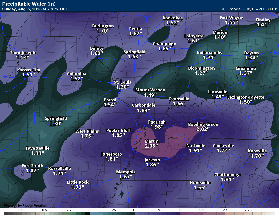
As it usually the case, there will be plenty of moisture in the atmosphere for thunderstorms to tap into. PWAT values will top 1.7″.
Thunderstorms that develop could drop an inch of rain in thirty minutes or less. That is the result of high PWAT values.
Here is the GFS model guidance PWAT value chart. You can see the surge of moisture along and ahead of the frontal boundary.
Click to enlarge the animation.
The greatest chance of rain will likely be Tuesday into Wednesday. It is during this time that the frontal boundary and disturbance will be closest to our local area.
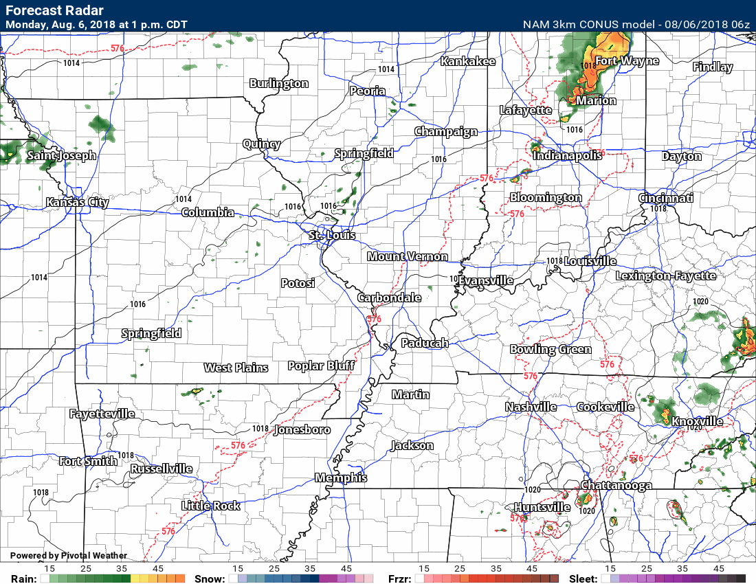
Here is the NAM future-cast radar animation. What it believes radar might look like over the coming 84 hours.
It is possible that the front stalls over our southern counties. If this happens then shower and thunderstorm chances will linger into the weekend. This remains an unknown.
If you have outdoor plans Friday into Sunday then you will want to monitor updated forecast numbers.
Temperatures this week will be seasonably warm. Highs mostly in the 86 to 94 degree range. Overnight lows in the 66 to 72 degree range.
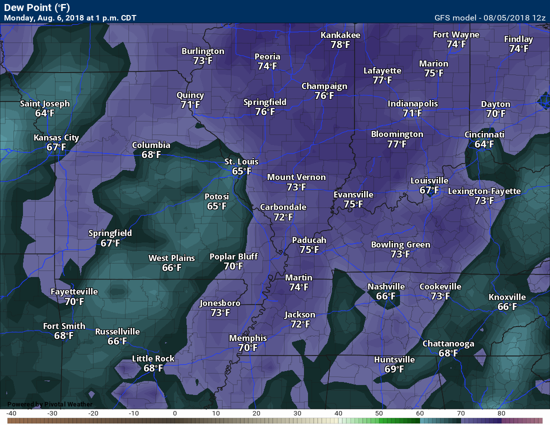
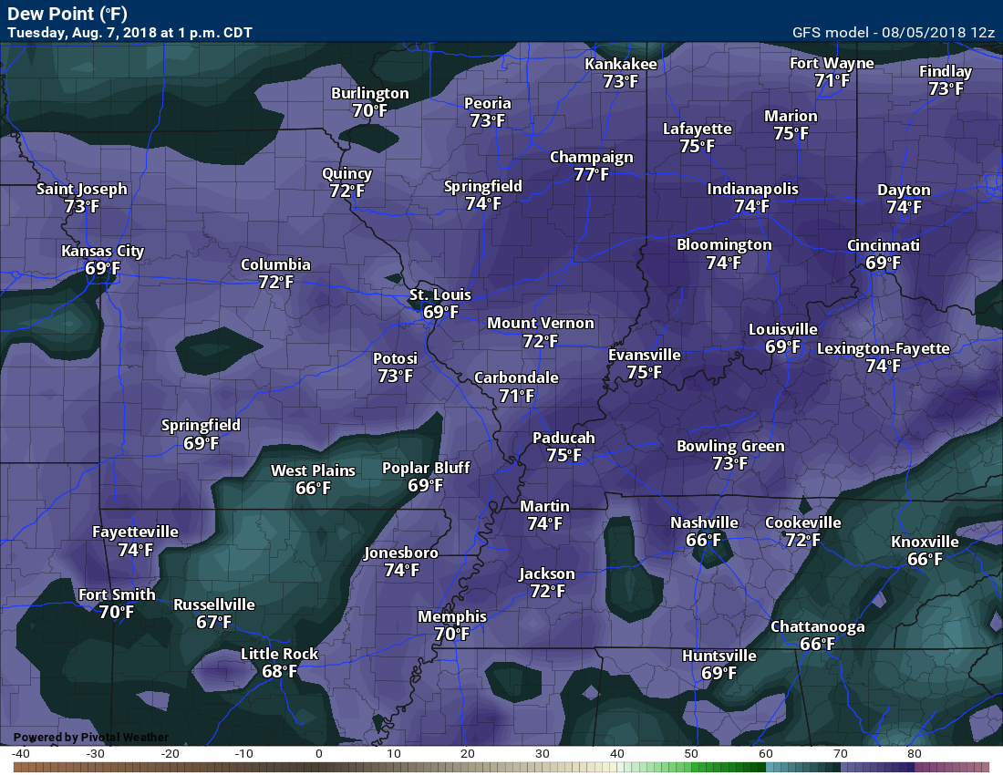
Dew points will be high Monday into at least Wednesday (esp along and south of the front). This will make it feel uncomfortable. Dew point is what controls how humid it feels outside. A lot of people like to use humidity. Humidity really does not tell the full story. Dew points do.
Monday 1 PM dew points
Tuesday 1 PM dew points
Wednesday 1 PM dew points

EC model guidance also shows high PWAT values
Dew Point Chart

.
The Final August forecast has been updated for subscribers
Subscribe at www.weathertalk.com
Outlook definitions
EQ = Equal chances of above or below normal
BN= Below normal
M/BN = Much below normal
AN = Above normal
M/AN = Much above normal
E/AN = Extremely above normal.

These videos are for subscribers.
Subscribe at www.weathertalk.com

These videos are for subscribers.
Subscribe at www.weathertalk.com

These videos are for subscribers.
Subscribe at www.weathertalk.com

I bring these to you from the BAMwx team. They are excellent long-range forecasters.
Remember, long-range outlooks are a bit of skill, understanding weather patterns, and luck combined. It is not an exact science.

Normal high temperatures for this time of the year are around 92 degrees.
Normal low temperatures for this time of the year are around 69 degrees.
Normal precipitation during this time period ranges from 0.25″ to 0.50″
This outlook covers August 6th through August 12th
These graphics are for subscribers.
Subscribe at www.weathertalk.com
The precipitation forecast is PERCENT OF NORMAL. For example, if your normal rainfall is 1.00″ and the graphic shows 10%, then that would mean 0.10″ of rain is anticipated.
Always keep in mind, slow moving summer thunderstorms can produce torrential rain. That could skew the rainfall outlook.
These graphics are for subscribers.
Subscribe at www.weathertalk.com

These graphics are for subscribers.
The precipitation forecast is PERCENT OF NORMAL. For example, if your normal rainfall is 1.00″ and the graphic shows 10%, then that would mean 0.10″ of rain is anticipated.
These graphics are for subscribers.
Subscribe at www.weathertalk.com

These graphics are for subscribers.
Subscribe at www.weathertalk.com
And precipitation
These graphics are for subscribers.
Subscribe at www.weathertalk.com
Temperature outlook for June through August.
These graphics are for subscribers.
Subscribe at www.weathertalk.com
July temperature and precipitation outlook
These graphics are for subscribers.
Subscribe at www.weathertalk.com
August temperature and precipitation outlook
These graphics are for subscribers.
Subscribe at www.weathertalk.com
![]()

A new weather podcast is now available! Weather Geeks (which you might remember is on The Weather Channel each Sunday)
To learn more visit their website. Click here.
![]()

WeatherBrains Episode 652
Tonight’s Guest WeatherBrain is a weather legend, having spanned four decades as a broadcast meteorologist. He is a Fellow of the AMS. Joe Witte, welcome to WeatherBrains!
Other discussions in this weekly podcast include topics like:
- Athletes who are passionate about weather
- What all is involved with TV weather internships
- NASA’s intern program
- KATV’s Ned Perme retiring after 34 years
- Astronomy Outlook with Tony Rice
- Drake University sportscaster Larry Cotlar dies in Iowa flash flooding
- and more!
Link to web-site https://weatherbrains.com/
Previous episodes can be viewed by clicking here.
We offer interactive local city live radars and regional radars. If a radar does not update then try another one. If a radar does not appear to be refreshing then hit Ctrl F5. You may also try restarting your browser.
The local city view radars also have clickable warnings.
During the winter months, you can track snow and ice by clicking the winterize button on the local city view interactive radars.
You may email me at beaudodson@usawx.com
Find me on Facebook!

Find me on Twitter!

Did you know that a portion of your monthly subscription helps support local charity projects?
You can learn more about those projects by visiting the Shadow Angel Foundation website and the Beau Dodson News website.

I encourage subscribers to use the app vs regular text messaging. We have found text messaging to be delayed during severe weather. The app typically will receive the messages instantly. I recommend people have three to four methods of receiving their severe weather information.
Remember, my app and text alerts are hand typed and not computer generated. You are being given personal attention during significant weather events.
