We have some great sponsors for the Weather Talk Blog. Please let our sponsors know that you appreciate their support for the Weather Talk Blog.
Milner and Orr Funeral Home and Cremation Services located in Paducah, Kentucky and three other western Kentucky towns – at Milner and Orr they believe in families helping families. You can find Milner and Orr on Facebook, as well.
![]()
.

Wortham Dental Care located in Paducah, Kentucky. The gentle dentist. Mercury free dentistry. They also do safe Mercury removal. You can find Wortham Dental Care on Facebook, as well
.

Trover’s Equipment and Lawn Care – Family owned and operated! They are a dealer for Snapper, Simplicity, Snapper Pro, Bad Boy Mowers, and Intimidator Utility Vehicles. They are a Stihl and Dolmar power products dealer. They also are a dealer for Briggs & Stratton, Kohler gas & diesel engines, and Kawasaki engines. They service and repair just about any brand. You can find them on Facebook, as well
.

Visit their web-site here. Or, you can also visit their Facebook page.
.

Endrizzi’s Storm Shelters – For more information click here. Endrizzi Contracting and Landscaping can be found on Facebook, as well – click here
.
Are you looking for a full service insurance agency that writes homes, businesses, and vehicles in Illinois, Kentucky, and Tennessee. Call Gary’s office at 270.442.8234 for rates and plans to protect what matters to you!

Gary Eckelkamp’s web-site click the above banner or click here
.

This forecast update covers far southern Illinois, far southeast Missouri, and far western Kentucky. See the coverage map on the right side of the blog.
Remember that weather evolves. Check back frequently for updates, especially during active weather.
The forecast numbers below may vary a bit across the region. These are the averages.
WEATHER RADAR PAGE – Click here —
Monday night – Partly cloudy. A 30% chance for a thunderstorm.
Temperatures: Lows in the 70’s
Winds: Northwest at 5-10 mph.
My confidence in this part of the forecast verifying is high
Should I cancel my outdoor plans? No, but there could be some storms around. Check radars
Is severe weather expected? Isolated risk
What is the chance for precipitation? 20%-30%
What impact is expected? None. If a storm forms then brief heavy rain and lightning.
Tuesday – Partly sunny. A 20%-30% chance for thunderstorms. Warm and humid.
Temperatures: Highs in the 90’s
Winds: Southwest at 10 mph. Winds will be variable near the stalled front.
My confidence in this part of the forecast verifying is medium
Should I cancel my outdoor plans? No
Is severe weather expected? Isolated risk
What is the chance for precipitation? 20%-30%
What impact is expected? Brief heavy rain, lightning, and gusty winds in areas that experience storms.
Tuesday night – Partly cloudy. A 40%-50% chance for a thunderstorm.
Temperatures: Lows in the 70’s
Winds: Northwest at 10-15 mph.
My confidence in this part of the forecast verifying is low to medium
Should I cancel my outdoor plans? No
Is severe weather expected? Isolated risk
What is the chance for precipitation? 40%-50%
What impact is expected? Storms could produce heavy rain, gusty winds, and lightning.
Wednesday – Partly sunny. A 40%-60% chance for thunderstorms. Warm and humid. Heavy rain possible.
Temperatures: Highs in the upper 80’s to perhaps some 90’s (depends on cloud cover). Temperatures could change. If we end up with a LOT more clouds and precipitation then some places stay quite a bit cooler than other areas. Keep this in mind.
Winds: Southwest at 10-15 mph
My confidence in this part of the forecast verifying is medium
Should I cancel my outdoor plans? Monitor radars. Storms will be possible. Could cause issues with outdoor plans.
Is severe weather expected? Isolated risk
What is the chance for precipitation? 40%-60%
What impact is expected? Brief heavy rain, lightning, and gusty winds in areas that experience storms.
Wednesday night – Partly cloudy. A 60%-70% chance for a thunderstorm. Locally very heavy rain possible in some areas. Flash flooding possible in the area that picks up the heaviest rain.
Temperatures: Lows in the 70’s
Winds: Variable winds at 10 mph.
My confidence in this part of the forecast verifying is low to medium
Should I cancel my outdoor plans? Could be some issues with rain. Monitor radars
Is severe weather expected? Isolated risk
What is the chance for precipitation? 60%-70%
What impact is expected? Heavy rain, lightning, and gusty winds in areas that experience storms. Flash flooding threat.
Thursday – A good chance for thunderstorms. Locally heavy rain possible.
Temperatures: Highs in the 80’s
Winds: Southwest at 10-15 mph. Winds becoming more west/northwest during the afternoon hours at 10-15 mph.
My confidence in this part of the forecast verifying is medium
Should I cancel my outdoor plans? Might want to monitor weather updates. Some storms will be possible.
Is severe weather expected? Isolated risk
What is the chance for precipitation? 60%
What impact is expected? Brief heavy rain, lightning, and gusty winds in areas that experience storms.
Some storms may remain in the forecast on Friday. Low confidence
Saturday and Sunday – very low confidence on the forecast. Will go with dry for now, but I am watching a storm system on Sunday.

![]()
Sunrise and Sunset Times – Click Here


Don’t forget to check out the Southern Illinois Weather Observatory web-site for weather maps, tower cams, scanner feeds, radars, and much more! Click here

An explanation of what is happening in the atmosphere over the coming days…
Highlights
1. Tuesday will bring warm and humid conditions
2. Locally heavy rain likely this week over portions of our region (centered over our northern half vs southern half?)
3. Some storms could be intense
The main story, as you may already have read from the past few days, is going to be a stalled front that will drape itself across our region. The front is currently over our northern counties (as of Monday afternoon). The front will stall out from tonight (Monday) through at least Thursday and maybe Friday. This is bad news if you don’t need rain chances to increase from time to time.
Ripples of low pressure and/or disturbances will move along this stalled front. Each disturbance will trigger showers and thunderstorms. The atmosphere will have plenty of moisture to work with. That means locally heavy rainfall totals will occur.
The heaviest rain will likely be right along and north of the cold front. The exact placement of the front will be key to determining who ends up with the most rain. Flash flooding will be likely in a few spots with this unfolding pattern. Perhaps the greatest risk will be Wednesday night.
Right now I am thinking the northern half of the region will have the best chance for big totals. If we were to draw a line from Piedmont, Missouri to Vienna, Illinois and then to Madisonville, Kentucky. Give or take one county. North of that line could have the biggest totals. But, that is absolutely not to say that south of that line won’t have heavy rain. They likely will, but perhaps not as widespread. So, you aren’t out of the woods south of that line.
Everyone should pick up 0.50″-1.50″ of rain this week. Then pockets of 2-4″ with localized amounts greater than 4″ of rain. Flash flooding will be possible in spots or at least brief flooding. This will especially be true if training occurs. Training is when storms move repeatedly over the same areas. Training can drop a quick 2-4″ of rain in a matter of one to two hours. When that occurs you typically have some runoff issues.
Perhaps the bigger forecast headache will be the exact timing and % chances for precipitation at any time and any given location.
For now I am going with
Scattered storms on Tuesday (30% or so)
An increase in coverage Tuesday night into Wednesday night (40%-60%)
Perhaps even widespread on Wednesday night and Thursday morning (60%+)
Scattered on Thursday afternoon (30% or so)
Perhaps isolated on Thursday night (20% or so)
Then perhaps another increase on Friday in coverage (low confidence)
The severe weather threat this week isn’t zero. But, widespread severe weather is also not anticipated. Perhaps the best chance for heavier storms (with damaging wind potential) might be on Wednesday. A stronger system will approach Wednesday into Wednesday night. Wind fields increase and instability increases. This combination could mean a few reports of wind damage. This will need to be monitored.
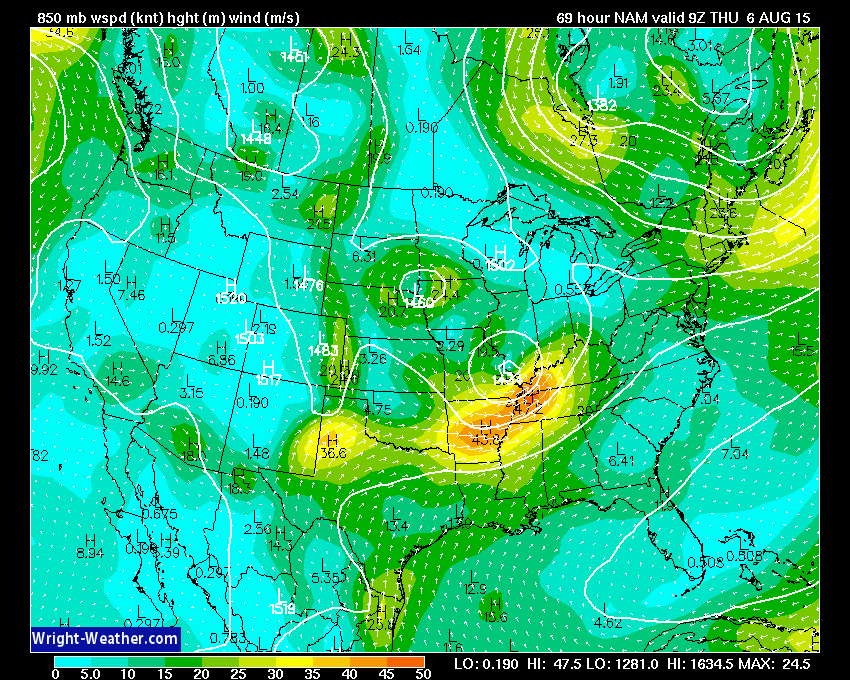
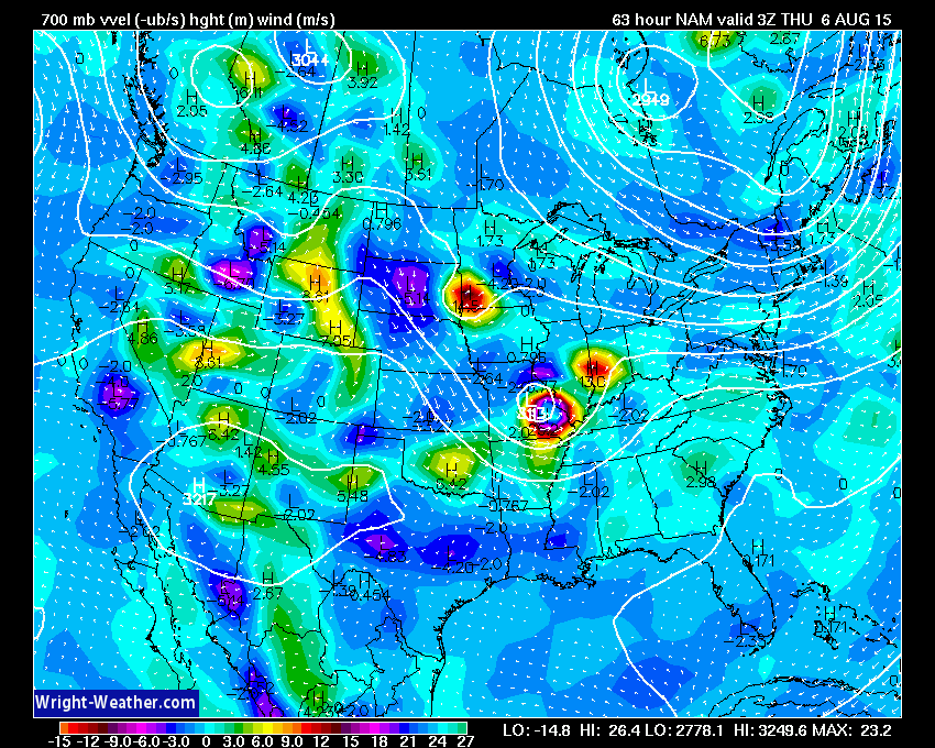
Let’s look at a few maps from wright-weather.com
These are the 850 mb wind fields for Wednesday evening and night. Some strong winds aloft to help with storms and heavy rain potential.
This map below shows lift. Some nice lift over our region. This will help with thunderstorm development. IF this model is correct.
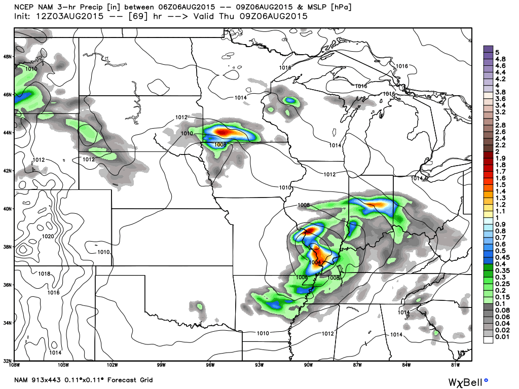
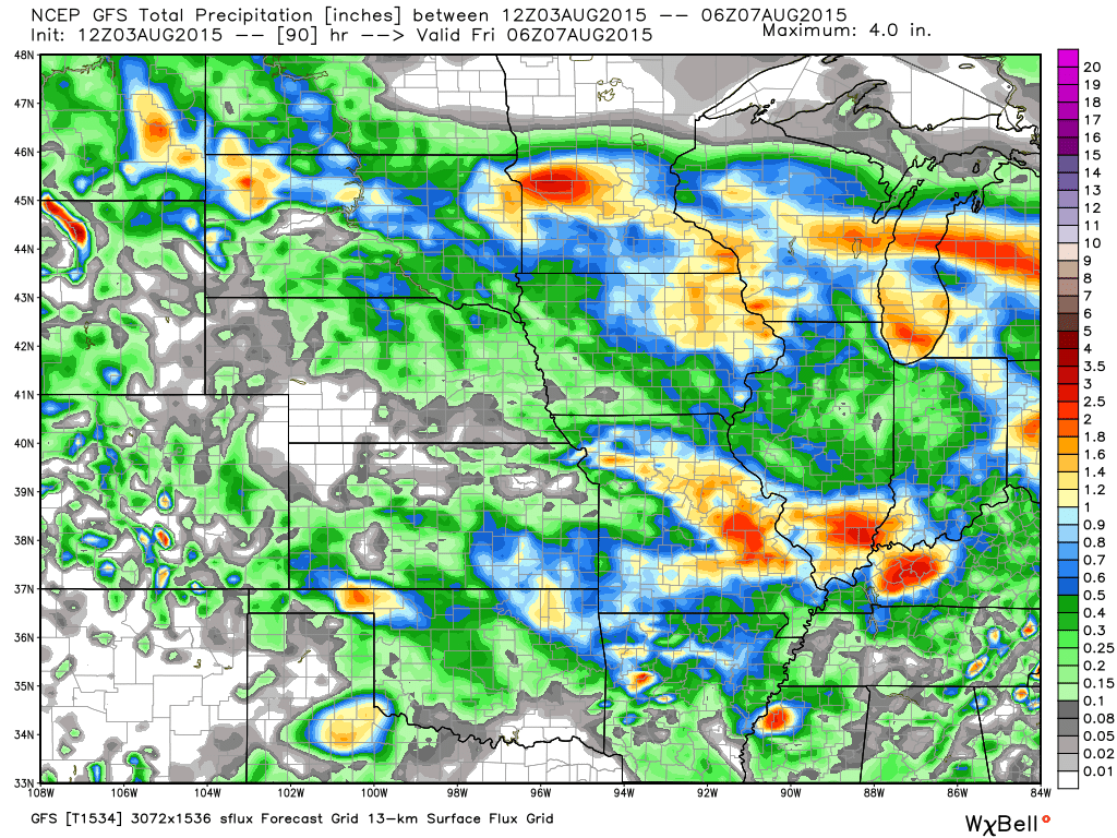
Now, some maps from weatherbell.com
This first map shows you precipitation (colors). This is for Wednesday night. Some heavy storms in our region. Might be a late night for forecasters. Especially if flash flooding is a concern. I do not like heavy storms at night in July or August. They can cause a lot of trouble (heavy rain-wise).
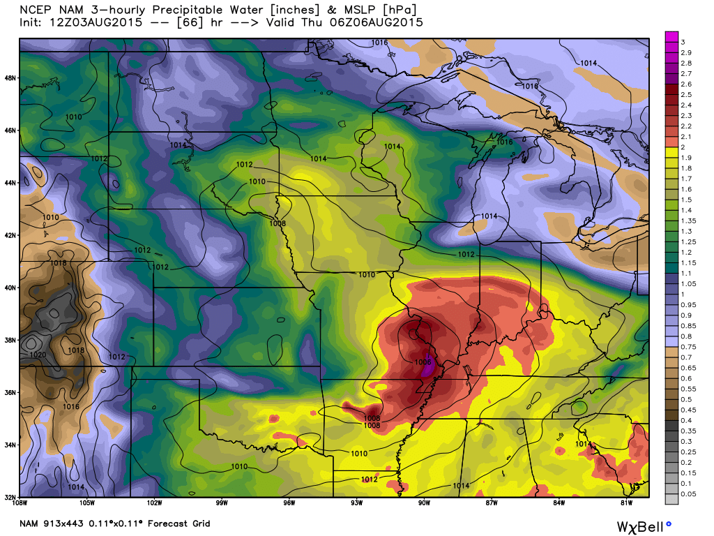
This is the total precipitation through Thursday. This is the NAM model. We will have to see if the placement of the heaviest rain is correct.
Click the map for a zoomed in view.
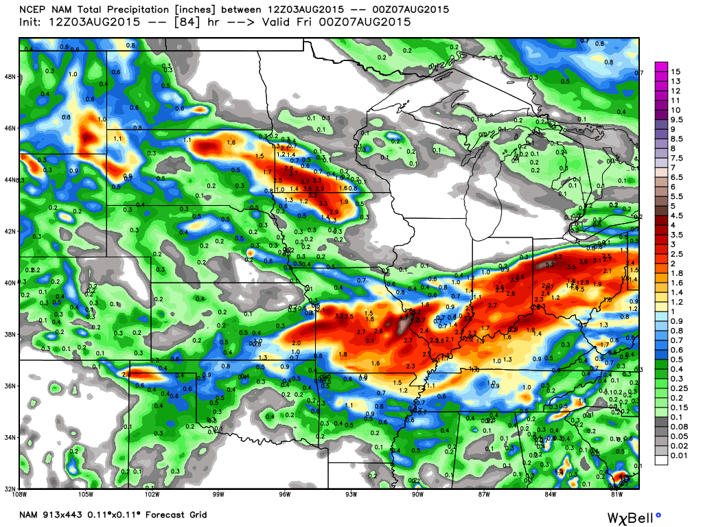
Of course, models don’t agree. They have not done well this summer. Here is the GFS (below). It shows rain over our region, but not nearly as much rain as the other model. Again, we will have to figure out the placement of the heaviest rain. Lower than normal confidence on how this all plays out.
The NAM has some impressive PWAT values for the Wednesday into Thursday morning time frame. This is a concern, if accurate. High PWAT values would mean heavy rain potential.
What are PWAT values? Great question! I found this blog post that explains it quite well. Click here for more information on PWAT values.
The map below is from weatherbell.com
What you should take from this is that rain and storm chances will increase over the coming days.
Best chances will be Tuesday night into Thursday morning. And perhaps again on Friday.
BUT, don’t forget we also have storm chances on Tuesday, as well. It just appears the more widespread precipitation would be Tuesday night into Thursday morning. Perhaps centered on the Wednesday night into Thursday morning time frame.
Temperatures will rise into the 90’s on Tuesday. Heat index values will again be around 100 or above. Use care if you have to be out in the sun. As always, use common sense.
Temperatures won’t be quite as warm Wednesday into Friday. Cloud cover and on/off rain chances should help keep temperatures in the 80’s.
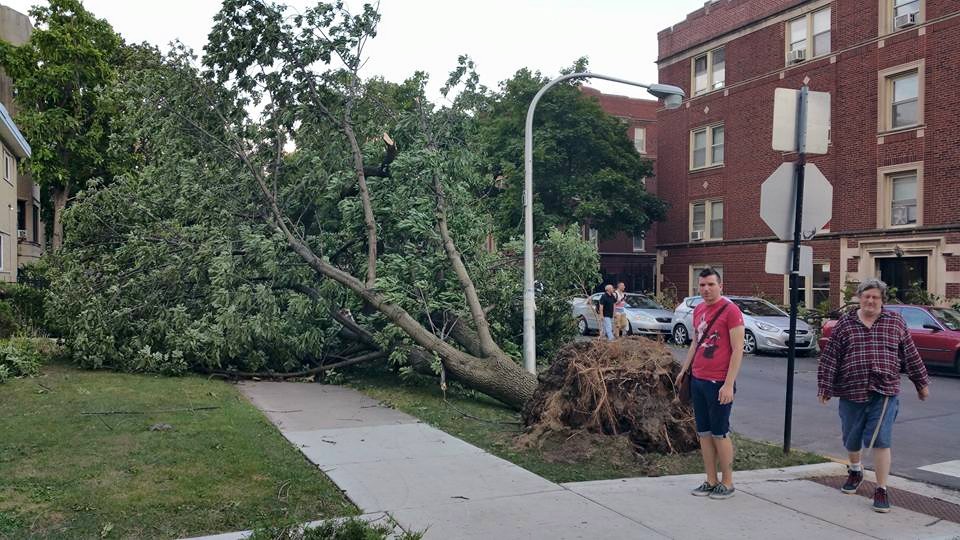
I am a big fan of photography, as some of you know. I am living both in Massac County and Chicago now! Back and forth.
I took these photographs in Millennium Park on Sunday. I thought I would share them with you.
For a larger view you can click the photograph.


Violent storms swept through Chicago soon after I took these photographs. Lot of tree damage. This is one photograph I took from Rodgers Park. A bad day for many residents.

This section of the blog is speculative forecast information. Because it is past the range of what meteorologists can forecast accurately, it should be considered speculation. Anything past day 5 is considered a long range forecast.
Highlights
1. Will it or won’t it cool off this coming weekend
2. Another trough and northwest flow next week?
Well, the models giveth and the models taketh away. But, is that a surprise. The models do not handle northwest flow patterns very well. A northwest flow pattern is when the jet stream dives down into our region from the northwest. When this happens we typically cool off a little bit and experience unsettled weather (in the summer).
A northwest pattern is what we will experience in our region from Tuesday into at least Friday.
A cold front was forecast to usher in cooler and drier air by Saturday and Sunday. Now the models have taken that away. But, that tends to lead me towards not having faith in their solutions. Lower than normal confidence as to what happens Friday into Sunday of this week.
If the front does move southward then we can expect cooler and drier weather. But, again…low confidence.
I will keep an eye on it. When models go back and forth then I just dismiss them. I typically check the ensembles and then take a wait and see approach.
Since the long range part of the forecast is always low confidence (or most of the time) I suppose it doesn’t really matter, yet.
Looking ahead to next week…
Another trough may develop over the Central United States. More northwest flow. That could mean more active weather. Such a strange pattern for summer. Par for the course?
Radars
WEATHER RADAR PAGE – Click here —

I also set up a storm tracking page with additional links (use during active weather for quick reference)
Storm Tracking Tool Page
Don’t forget to support our sponsors!

How much precipitation should we expect over the next few days?
Once again a complicated rainfall setup is taking shape for the region. If you remember the hit and miss heavy rain in July then you will know what to expect this week.
Location, location, location. The location of the stalled cold front will be key to who ends up with heavy rain. Rainfall totals of 2-4″ will be possible this week in some of our local counties. Each disturbance moving along the front will need to be monitored. Heavy rain is likely in some counties as each wave moves along the front.
Some spots could exceed 4 inches of rain this week. That could occur if training sets up. Training is when storms move over the same area repeatedly. We had this in July. It can produce very heavy rainfall totals in short periods of time.
Flash flooding is a concern with a pattern like this. You will want to monitor updates.
Widespread 0.50″-1.50″ of rain is forecast for the region between now and Friday. And, locally heavy rain is likely (as mentioned above).

Can we expect severe thunderstorms over the next 24 to 48 hours? Remember that a severe thunderstorm is defined as a thunderstorm that produces 58 mph winds or higher, quarter size hail or larger, and/or a tornado.
Thunderstorm threat level is TWO. Thunderstorms are possible over the coming days. Especially Tuesday night through Wednesday night/Thursday morning. Some storms could be on the heavy side. I can’t completely rule out a severe thunderstorm.
Tuesday: No severe weather anticipated. Some scattered storms possible. If storms occur or develop then they could be on the heavy side. Lightning and gusty winds. Severe weather risk is minimal.
Wednesday: Thunderstorms are possible. Isolated severe weather risk.
Thursday: Thunderstorms are possible. Isolated severe weather risk.
Friday: We may still have to deal with thunderstorm chances on Friday, as well.
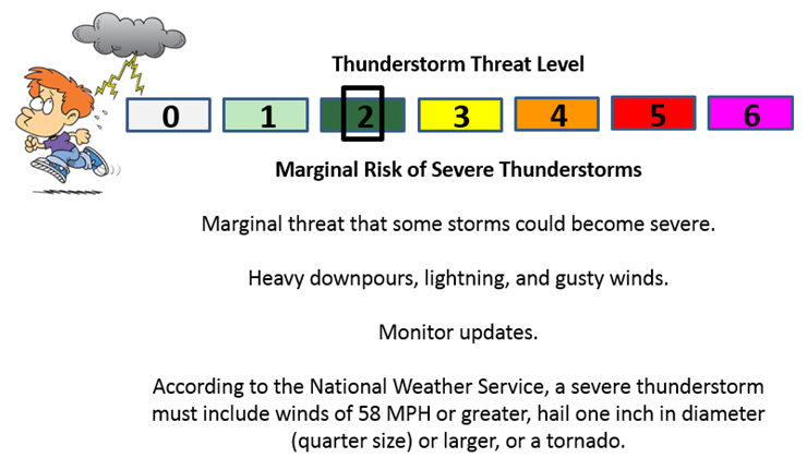

The main concern over the coming week will be on and off thunderstorm chances. Where storms occur they could be on the heavy side. Isolated severe weather risk.
There will once again be a lot of moisture in the atmosphere for storms to work with. These means that if storms train over the same areas that rainfall totals could be excessive. This will need to be monitored for flash flooding. A similar pattern occurred in July, as many of you remember.
There is a small risk for severe weather. Wind fields increase a bit on Wednesday. That will need to be monitored. Increasing wind fields is a concern for severe weather. Monitor updates.

Here are the current river stage forecasts. You can click your state and then the dot for your location. It will bring up the full forecast and hydrograph.
Click Here For River Stage Forecasts…
Here are some current forecast hydrographs. These will be updated each day with new information.


Smithland Lock and Dam

Paducah, Kentucky Forecast Stage

Cairo, Illinois

Cape Girardeau, Missouri
Current Temperatures Around The Local Area


We have regional radars and local city radars – if a radar does not seem to be updating then try another one. Occasional browsers need their cache cleared. You may also try restarting your browser. That usually fixes the problem. Occasionally we do have a radar go down. That is why I have duplicates. Thus, if one fails then try another one.
If you have any problems then please send me an email beaudodson@usawx.com
WEATHER RADAR PAGE – Click here —
We also have a new national interactive radar – you can view that radar by clicking here.
Local interactive city radars include St Louis, Mt Vernon, Evansville, Poplar Bluff, Cape Girardeau, Marion, Paducah, Hopkinsville, Memphis, Nashville, Dyersburg, and all of eastern Kentucky – these are interactive radars. Local city radars – click here
NOTE: Occasionally you will see ground clutter on the radar (these are false echoes). Normally they show up close to the radar sites – including Paducah.

Regional Radar – Click on radar to take you our full radar page.


Regional Radar

Live Lightning Data – zoom and pan: Click here
Live Lightning Data with sound (click the sound button on the left side of the page): Click here
I also set up a storm tracking page with additional links (use during active weather for quick reference)
Storm Tracking Tool Page
![]()
Current WARNINGS (a warning means take action now). Click on your county to drill down to the latest warning information. Keep in mind that there can be a 2-3 minute delay in the updated warning information.
I strongly encourage you to use a NOAA Weather Radio or warning cell phone app for the most up to date warning information. Nothing is faster than a NOAA weather radio.


Color shaded counties are under some type of watch, warning, advisory, or special weather statement. Click your county to view the latest information.

Missouri Warnings

Illinois Warnings

Kentucky Warnings

Here is the official 6-10 day and 8-14 day temperature and precipitation outlook. Check the date stamp at the top of each image (so you understand the time frame).
The forecast maps below are issued by the Weather Prediction Center (NOAA).


The latest 8-14 day temperature and precipitation outlook. Note the dates are at the top of the image. These maps DO NOT tell you how high or low temperatures or precipitation will be. They simply give you the probability as to whether temperatures or precipitation will be above or below normal.


Who do you trust for your weather information and who holds them accountable?
I have studied weather in our region since the late 1970’s. I have 37 years of experience in observing our regions weather patterns. My degree is in Broadcast Meteorology from Mississippi State University and an Associate of Science (AS). I am currently working on my Bachelor’s Degree in Geoscience. Just need to finish two Spanish classes!
I am a member of the American Meteorological Society. I am a NOAA Weather-Ready Nation Ambassador. And, I am the Meteorologist for McCracken County Emergency Management.
I own and operate the Southern Illinois Weather Observatory.
There is a lot of noise on the internet. A lot of weather maps are posted without explanation. Over time you should learn who to trust for your weather information.
My forecast philosophy is simple and straight forward.
- Communicate in simple terms
- To be as accurate as possible within a reasonable time frame before an event
- Interact with you on Twitter, Facebook, and the blog
- Minimize the “hype” that you might see on television or through other weather sources
- Push you towards utilizing wall-to-wall LOCAL TV coverage during severe weather events
I am a recipient of the Mark Trail Award, WPSD Six Who Make A Difference Award, Kentucky Colonel, and the Caesar J. Fiamma” Award from the American Red Cross. In 2009 I was presented with the Kentucky Office of Highway Safety Award. I was recognized by the Kentucky House of Representatives for my service to the State of Kentucky leading up to several winter storms and severe weather outbreaks.
If you click on the image below you can read the Kentucky House of Representatives Resolution.

I am also President of the Shadow Angel Foundation which serves portions of western Kentucky and southern Illinois.
Many of my graphics are from www.weatherbell.com – a great resource for weather data, model data, and more


You can sign up for my AWARE email by clicking here I typically send out AWARE emails before severe weather, winter storms, or other active weather situations. I do not email watches or warnings. The emails are a basic “heads up” concerning incoming weather conditions.