September 1, 2017
Midnight
Rain continues over the area. Heaviest rain was located in south central Kentucky where 1 to 3 inches has already fallen and several more inches will fall.
Murray, Kentucky has received one to one and a half inches of rain, thus far. That was about an hour ago with two reporting stations/spotters. Rain will continue all night in the Murray area.
Rainfall totals are highest over the Missouri Bootheel (locally). Totals of three to four inches have been noted on radar. There may be some five inch reports from the Bootheel.
Light to moderate rain continues over extreme southern Illinois into Kentucky/Tennessee.
It still appears the heaviest rain will fall from near Murray into south central Kentucky.
The center of the remnants of Harvey are located over northeast Mississippi. It is just now moving into Tennessee. Slowly moving into Tennessee, I should say. It is not in any hurry.
Some guidance stalls the system over Kentucky tomorrow. If that happens then clouds and some rain will linger into the afternoon for southeast Illinois and portions of western Kentucky and Tennessee. The further east you travel the more likely you will run into rain.
Flash flood watch continues for much of western Kentucky and western Tennessee. The overall flash flood risk may be low over extreme western Kentucky. Greater chances for problems as you move into south central Kentucky.
August 31, 2017
9 PM update
No major changes in the forecast. Harvey is a bit further south than anticipated. We knew that was a possibility. It is just now starting to enter Tennessee. Slow mover.
Widespread rain is falling from the Bootheel of Missouri into western Kentucky and Tennessee. The tropical rains are prolific raindrop producers. Warm cloud temperatures. Lot of moisture in the atmosphere.
Rain totals seem to be on track. I feel confident about the lower end numbers. I still am not sure about the three to six numbers. We will see how it pans out.
My earlier forecast numbers will hold. That is the forecast. See the graphics in the 2 pm update.
Tornado risk tonight is near zero. Numerous tornado warnings today in western and central Tennessee. That is where the higher risk of tornadoes was located. The low is not far enough north and west for our region to have tornadoes.
The rain will continue all night over the Missouri Bootheel, Kentucky, and Tennessee. Some of the rain will spread into extreme southern Illinois, as well.
Wind gusts to 30 mph have been reported this evening. Gusty winds will last into Friday.
Rain will come to an end on Friday afternoon. Not sure how much rain remains before 2 pm. I do think widespread rain is likely over portions of western Kentucky and perhaps western Tennessee well into the morning. We will have to monitor southeast Illinois, as well.
August 31, 2017
2 PM Update
Concerns
- Today’s guidance all shifted south and east with the big big totals. Something worth monitoring.
- Small tornado risk this afternoon and tonight along the KY/TN border and in Tennessee. Somewhat greater risk as you travel south and east into Tennessee.
- Gusty winds likely as we continue to push into the evening and overnight hours. Would not be surprised to some reports of 40 to 50 mph gusts. Part of that will depend on the exact track of Harvey and the tightening pressure gradient.
The WPC has shifted the high risk for flash flooding slightly west/northwest. This is in response to ongoing issues in the Missouri Bootheel.
Questions remain on the heavier rain totals.
The overall trend in almost all of the guidance is to shift the heavier rain totals south and east of most of our area. This raises concerns about the ongoing forecast. Although, my probabilities do capture that uncertainty.
High confidence on the low end rain totals. Lower confidence on the three to six and six and above totals.
Medium confidence for the overall forecast.
Local City View Radars to track the storms
http://www.weatherobservatory.com/weather-radar.htm
Interactive national radar
http://weather.weatherobservatory.com/interactive/
There remain questions on placement of the heaviest rain. Models are all over the place and I don’t put much faith in model rainfall totals. They aren’t really supposed to be used for exact numbers. They are to be used for guidance.
The actual center of Harvey is a bit further south and east than some of the guidance. It is moving northeast. This may be a clue as to where the heavier rain ends up falling.
The red L is the center. This is a 2 pm image.

I have updated the probability numbers. They are probabilities. Keep that in mind. The higher probabilities obviously have a higher chance of verifying. The lower the probability the greater the uncertainty.
There has been a general trend south and east for the heaviest rain totals. Whether this ends up being correct or not remains a solid question.
One-half inch to one inch of rain
One to three inches of rain
Three to six inches of rain.
Greater than six inches of rain
Lower confidence on these big numbers. Still disagreement on the track of the center of Harvey
Let me show you the morning rainfall totals from models. You can see what I mean about a shift south/east.
GFS American model
NAM American model
NAM 3K High Resolution American model
SHARP cut-off between those with a lot of rain and those with very little rain.

HRRR through Friday at 6 AM
High resolution American model
HRRR is WAY WAY south and east with heavy rain. If this verifies then we would miss most of the heavy rain. Questionable based on current radar trends
EC European model
Canadian model
Here is your day by day weather outlook into Labor Day
.
Thursday Night Forecast Details:
Forecast: Cloudy. Rain. Some lightning possible. Heavy rain likely over portions of the region (see graphics above). Monitor updates. Windy. High winds possible. Best chance for heavy rain will be the Missouri Bootheel into extreme southern Illinois and then Kentucky/Tennessee. Highest totals will be over Kentucky and Tennessee.
Temperatures: MO ~ 62 to 66 IL ~ 62 to 66 KY ~ 62 to 66 TN ~ 62 to 66
Winds: North and northeast at 15 to 25 mph becoming gusty. Gusts above 40 mph possible.
What impacts are anticipated from the weather? Wet roadways. Isolated lightning. Heavy rain. Isolated tornado risk. Flash flooding risk, esp for KY/TN. High winds possible.
My confidence in the forecast verifying: High. This forecast should verify.
Is severe weather expected? Isolated tornado risk. Flash flooding possible.
The NWS defines severe weather as 58 mph winds or great, 1″ hail or larger, and/or tornadoes
What is the chance of precipitation? MO ~ 70% IL ~ 80% KY ~ 100% TN ~ 100% (keep in mind that far northern counties will see lower rain chances vs southern half of the region)
Coverage of precipitation: Widespread.
Should I cancel my outdoor plans? Have a plan B
.
September 1, 2017
Friday Forecast Details
Forecast: Cloudy. Rain (lightning possible) likely over portions of southern Illinois, Kentucky, and Tennessee. Lesser chances as you move further west and north. Areas like Poplar Bluff, Missouri and Farmington, Missouri will likely see dry conditions as we move through the day. Windy with high winds possible. Cooler.
Temperatures: MO ~ 73 to 78 IL ~ 72 to 76 KY ~ 72 to 76 TN ~ 72 to 76
Winds: South and southeast at 15 mph with gusts to 40 mph with higher gusts possible
What impacts are anticipated from the weather? Wet roadways. Isolated lightning. Gusty winds. Flash flooding possible. Tornado risk should have dwindled.
My confidence in the forecast verifying: Medium. Some adjustments are possible.
Is severe weather expected? The tornado risk should have ended. Monitor updates and see risk charts above.
The NWS defines severe weather as 58 mph winds or great, 1″ hail or larger, and/or tornadoes
What is the chance of precipitation? MO ~ 60% IL ~ 70% KY ~ 70% TN ~ 70%
Coverage of precipitation: Numerous before 3 pm. Becoming more scattered late in the day. Rain lingers longer over the eastern half of the region.
Should I cancel my outdoor plans? Have a plan B
.
Friday Night Forecast Details:
Forecast: Cloudy. Rain possible over southeast Illinois, portions of western Kentucky, and northwest Tennessee. Rain should end from southwest to northeast. The system may slow a bit. This would keep rain chances lingering.
Temperatures: MO ~ 50 to 56 IL ~ 50 to 56 KY ~ 55 to 60 TN ~ 55 to 60
Winds: North winds at 8 to 16 mph with gusty winds, at times. Winds will depend on where the remnants of Harvey track. Winds should diminish through the night as Harvey pulls away.
What impacts are anticipated from the weather? Wet roadways. Watch for flooded roads.
My confidence in the forecast verifying: Medium. Some adjustments are possible.
Is severe weather expected? No.
The NWS defines severe weather as 58 mph winds or great, 1″ hail or larger, and/or tornadoes
What is the chance of precipitation? MO ~ 20% IL ~ 40% KY ~ 50% TN ~ 50%
Coverage of precipitation: Scattered to perhaps numerous early and then ending from southwest to northeast.
Should I cancel my outdoor plans? Have a plan B (esp southeast IL, Kentucky, and Tennessee)
.
September 2, 2017
Saturday Forecast Details
Forecast: Partly to perhaps mostly sunny. Morning clouds may linger over southeast Illinois, Kentucky, and Tennessee, Rain should have ended.
Temperatures: MO ~ 76 to 82 IL ~ 76 to 82 KY ~ 76 to 82 TN ~ 76 to 82
Winds: North and northwest winds at 6 to 12 mph. Gusts to 20 mph.
What impacts are anticipated from the weather? Most likely none.
My confidence in the forecast verifying: Medium. Some adjustments are possible.
Is severe weather expected? No
The NWS defines severe weather as 58 mph winds or great, 1″ hail or larger, and/or tornadoes
What is the chance of precipitation? MO ~ 10% IL ~ 10% KY ~ 20% TN ~ 10%
Coverage of precipitation: Rain should have ended.
Should I cancel my outdoor plans? No
.
Saturday Night Forecast Details:
Forecast: Clearing. Patchy fog possible.
Temperatures: MO ~ 54 to 58 IL ~ 52 to 56 KY ~ 54 to 58 TN ~ 54 to 58
Winds: Northwest at 5 to 10 mph
What impacts are anticipated from the weather? Patchy fog.
My confidence in the forecast verifying: Medium. Some adjustments are possible.
Is severe weather expected? No.
The NWS defines severe weather as 58 mph winds or great, 1″ hail or larger, and/or tornadoes
What is the chance of precipitation? MO ~ 0% IL ~ 0% KY ~ 0% TN ~ 0%
Coverage of precipitation: Most likely none
Should I cancel my outdoor plans? No
.
September 3, 2017
Sunday Forecast Details
Forecast: Mostly sunny. Perhaps some morning fog.
Temperatures: MO ~ 78 to 84 IL ~ 78 to 84 KY ~ 78 to 84 TN ~ 78 to 84
Winds: Variable winds at 4 to 8 mph with gusts to 12 mph
What impacts are anticipated from the weather? Patchy morning fog could reduce visibility.
My confidence in the forecast verifying: Medium. Some adjustments are possible.
Is severe weather expected? No
The NWS defines severe weather as 58 mph winds or great, 1″ hail or larger, and/or tornadoes
What is the chance of precipitation? MO ~ 0% IL ~ 0% KY ~ 0% TN ~ 0%
Coverage of precipitation: None
Should I cancel my outdoor plans? No
Sunday Night Forecast Details:
Forecast: Mostly clear. Patchy fog possible.
Temperatures: MO ~ 62 to 66 IL ~ 62 to 66 KY ~ 62 to 66 TN ~ 62 to 66
Winds: South and southwest winds at 4 to 8 mph
What impacts are anticipated from the weather? Most likely none.
My confidence in the forecast verifying: Medium. Some adjustments are possible
Is severe weather expected? No.
The NWS defines severe weather as 58 mph winds or great, 1″ hail or larger, and/or tornadoes
What is the chance of precipitation? MO ~ 0% IL ~ 0% KY ~ 0% TN ~ 0%
Coverage of precipitation: Most likely none
Should I cancel my outdoor plans? No
.
September 4, 2017
Monday Forecast Details
Forecast: Partly to mostly sunny. Mild.
Temperatures: MO ~ 82 to 86 IL ~ 82 to 86 KY ~ 82 to 86 TN ~ 82 to 86
Winds: South and southwest winds at 5 to 10 mph
What impacts are anticipated from the weather? Perhaps morning fog.
My confidence in the forecast verifying: Medium. Some adjustments are possible.
Is severe weather expected? No
The NWS defines severe weather as 58 mph winds or great, 1″ hail or larger, and/or tornadoes
What is the chance of precipitation? MO ~ 10% IL ~ 10% KY ~ 10% TN ~ 10%
Coverage of precipitation: None
Should I cancel my outdoor plans? No.
.
Monday Night Forecast Details:
Forecast: A few clouds. Patchy fog possible.
Temperatures: MO ~ 62 to 66 IL ~ 62 to 66 KY ~ 62 to 66 TN ~ 62 to 66
Winds: Variable at 5 to 10 mph
What impacts are anticipated from the weather? Patchy fog
My confidence in the forecast verifying: Medium
Is severe weather expected? No
The NWS defines severe weather as 58 mph winds or great, 1″ hail or larger, and/or tornadoes
What is the chance of precipitation? MO ~ 20% IL ~ 20% KY ~ 10% TN ~ 10%
Coverage of precipitation: None anticipated
Should I cancel my outdoor plans? No
.
Previous update below
August 31, 2017
7 AM update
I will update this page as necessary throughout the day. I will also have some Beau Dodson Weather Facebook threads running.
Updates will be posted at the top of the page.
I have opened this page for free today.
If you have not subscribed to all of this data, then please do so. Average monthly costs exceed $2000.00. That is what I pay to bring you this data.
You can subscribe for $3 a month and receive app texts, videos, blog updates, severe weather alerts, daily forecasts, daily texts to all the posts and videos, and more
Register at www.beaudodsonweather.com
A new website and app will be rolled out soon.
Subscribers, the September outlook has been updated. You can view those links by clicking here
CONCERNS FOR TODAY THROUGH FRIDAY AFTERNOON
- Periods of heavy rain are likely. The time frame for the heaviest rain is tonight (Thursday night) into Friday morning. It is during this time that the core of the system will pass through Kentucky and Tennessee. Rainfall totals of 0.50″ to 1″ per hour will be possible. There could be pockets of greater than one inch per hour.
- Isolated tornado risk for portions of Kentucky/Tennessee.
- Gusty winds will begin this afternoon. The winds will increase tonight into Friday. Highest winds will likely be from the Missouri Bootheel into extreme southern Illinois, western Kentucky, and western Tennessee. Winds may gust above 50 mph. Be aware of this. As the center of the remnants of Harvey moves through our region there could be high winds.
Confidence in the forecast is as follows
Southeast Missouri ~ Medium
Southern Illinois ~ Medium
Western Kentucky ~ Medium/High
Western Tennessee ~ High
There are MAJOR differences in the model outlooks for this event.
Some models are further southeast with the track of the area of low pressure. Keep this in mind.
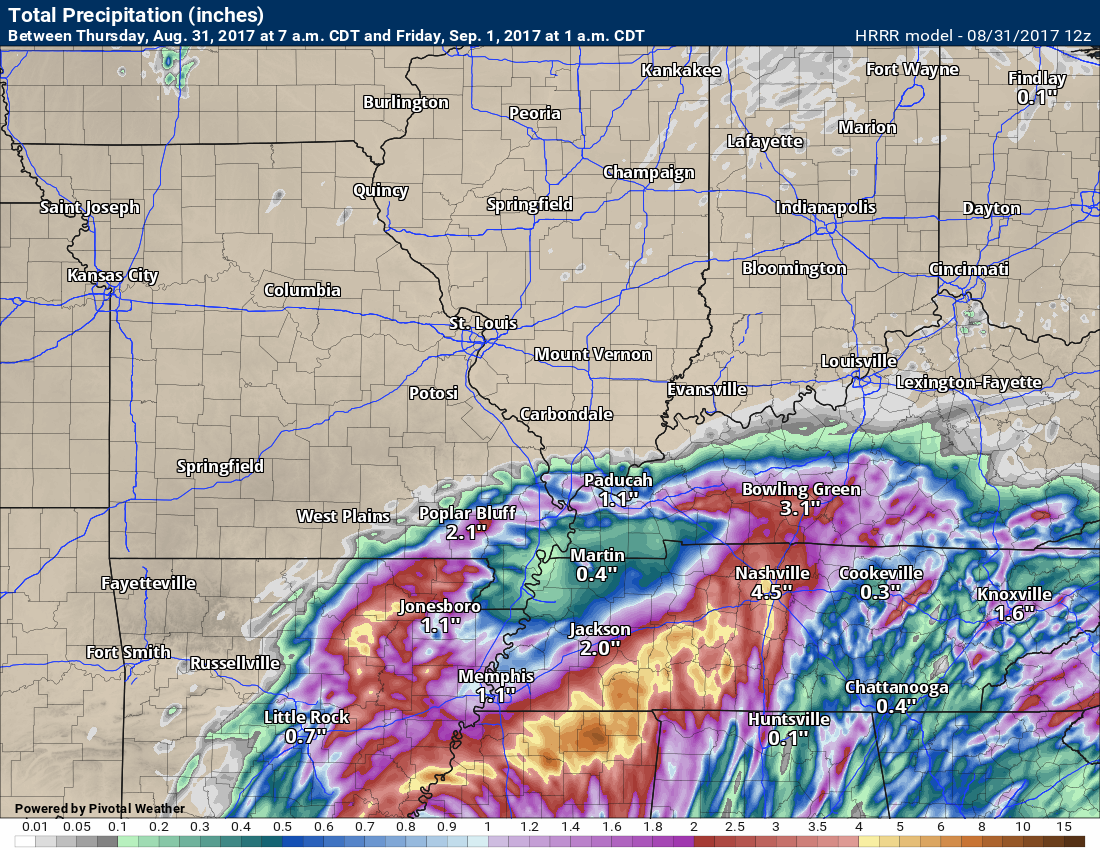
Here are the HRRR rainfall totals through 1 am tonight. Notice how low they are.
Click to enlarge.
This does not add a lot of confidence to the forecast.
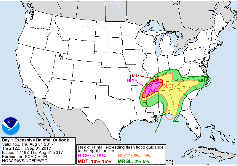
The WPC has issued a marginal risk for flash flooding over portions of southeast Missouri and southern Illinois (green color).
There is a slight risk for flash flooding over portions of southeast Missouri and Kentucky (the yellow zone)
There is a moderate risk of flash flooding in the red zone. That includes portions of western Kentucky and western Tennessee.
There is a high risk for flash flooding near LBL into much of western Tennessee (the pink zone)
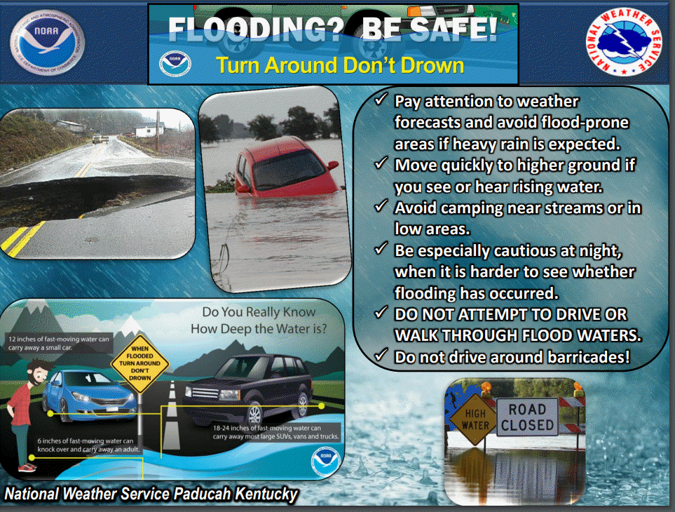
Be aware of rapidly changing weather conditions, especially tonight. Flash flooding at night is especially dangerous. In most flash flood events we have several water rescues. Avoid flooded roadways.
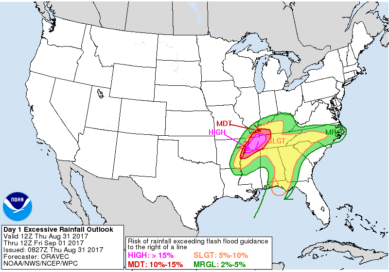
There is a moderate risk for flash flooding on Friday for portions of western Kentucky. That would be the red color.

Keep in mind, the atmosphere will be loaded with moisture. It won’t be unusual, under the heaviest cores, to experience 0.50″ to 1″ of rain per hour. This could cause flash flooding.
Avoid flooded roadways. See flood/flash flood probabilities below.
Use common sense. Don’t drive through rapidly flowing water. Water may be deeper than you realize. Every time we have flash flood someone drives into the flood waters. Avoid flooded roads.
The flash flood threat will be highest at night. That could mean you won’t see the road flooded until it is too late.
.
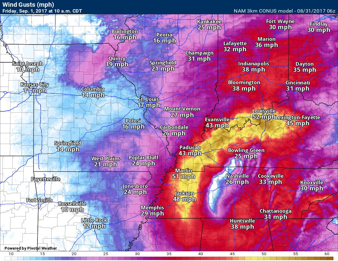
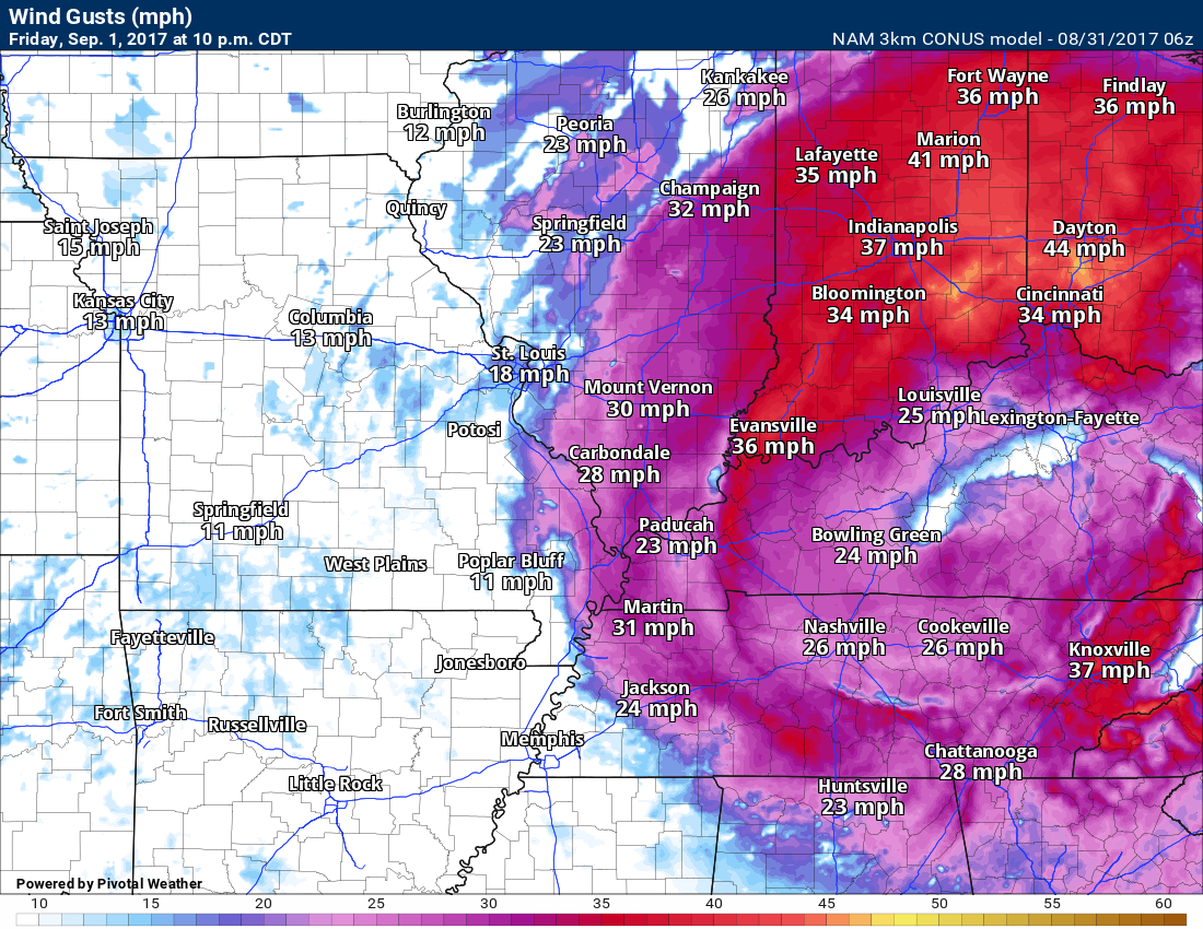
Wind Forecast
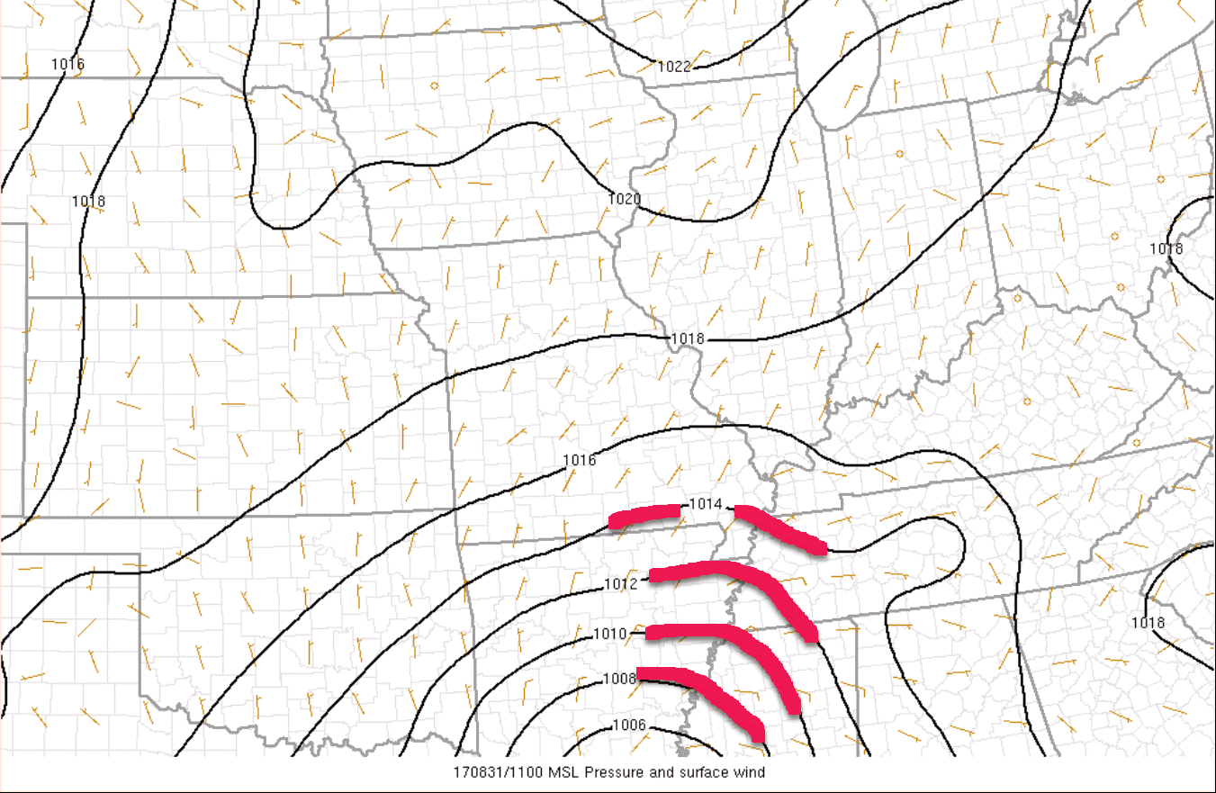
Strong and gusty winds will develop as the remnants of Harvey move northeast into Tennessee. A tightening pressure gradient will set up over our region. The tighter the pressure gradient, the strong the wind gusts.
See these black lines? Those are isobars. Isobars are equal lines of pressure.
I outlined a few in red. Isobars. They will tighten as the day wears on and especially tonight/Friday.
Winds in the 15 to 30 mph range will be common. Wind gusts above 50 mph are possible. The highest winds will likely occur from far southeast Missouri into extreme southern Illinois, Kentucky, and Tennessee.
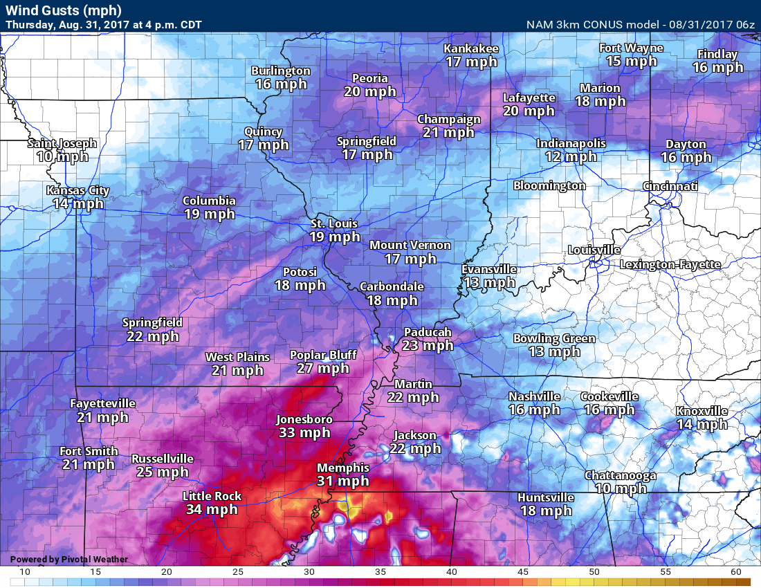
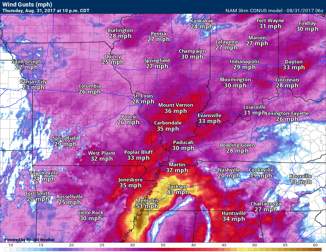
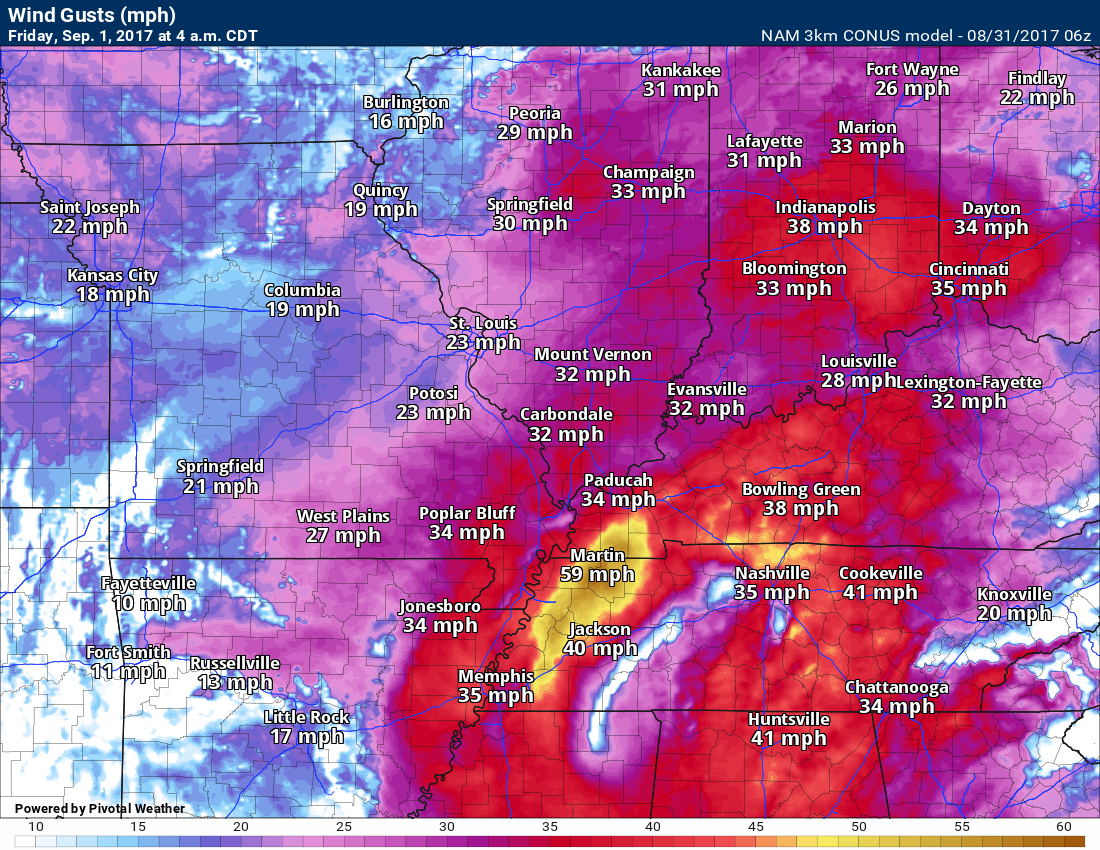
NAM 3K Model wind forecast.
There is the potential for winds above 50 mph. Keep in mind, this is a model. This is for guidance. It isn’t gospel. Models are not perfect. Take the general idea from this graphic that strong and gusty winds are possible tonight into Friday.
4 PM Thursday
Click to enlarge
This is the wind GUST map.
10 PM Thursday
Click image to enlarge
4 AM Friday
Wind gust map
There is the potential for winds above 50 mph. Keep in mind, this is a model. This is for guidance. It isn’t gospel. Models are not perfect. Take the general idea from this graphic that strong and gusty winds are possible tonight into Friday.
10 AM Friday
4 AM Friday

10 PM Friday
You can see the system pulling away on Friday night
A wind advisory covers most of the area for this afternoon into Friday evening.
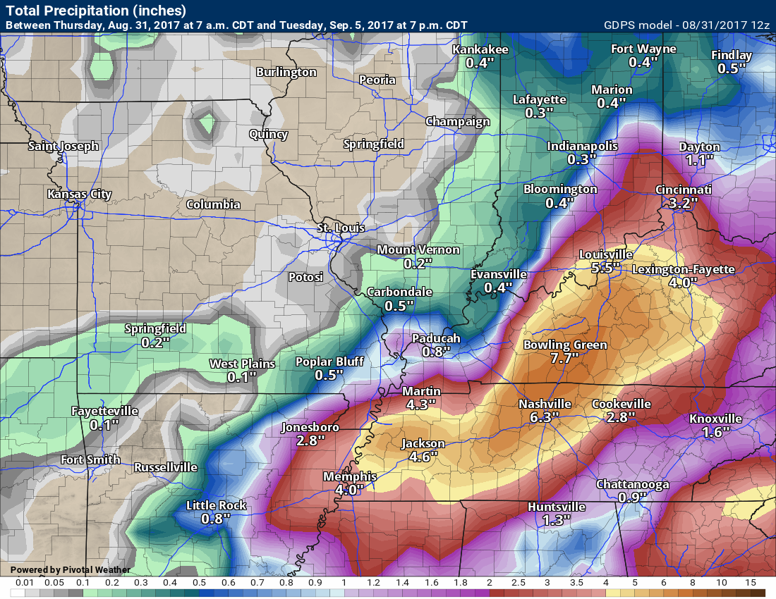
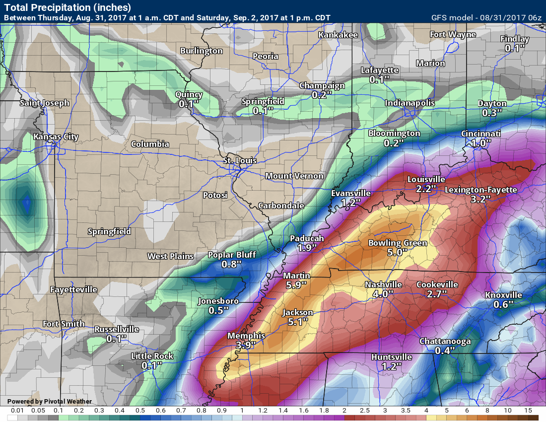
Rainfall totals
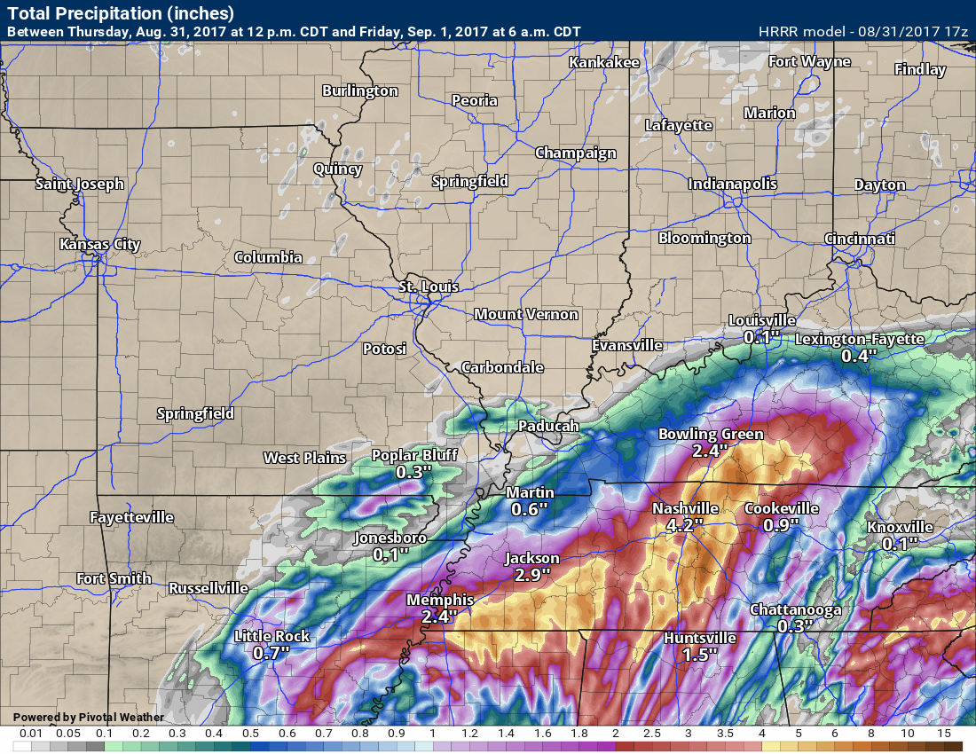
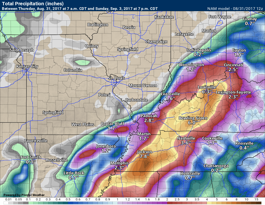
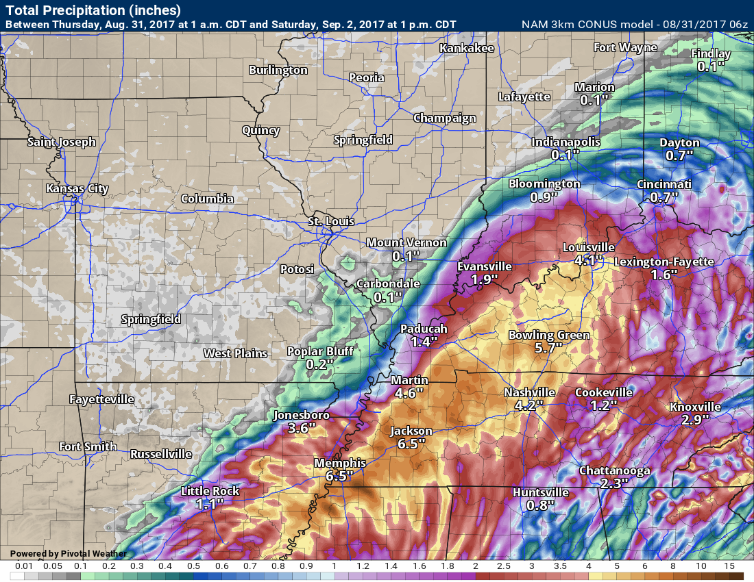
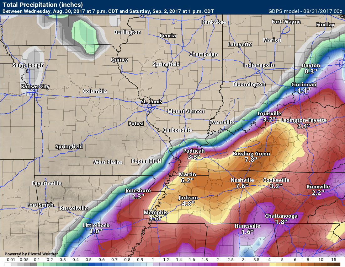
Let’s take a look at four models. These are their opinions on rainfall totals.
Models do not handle tropical moisture all that well. Models are for guidance and not gospel. You can see my actual rainfall forecast in the probability section below.
With that said, here are what the models are spitting out. Huge differences between certain models. Notice the sharp gradient in Missouri and Illinois. Some areas will receive little in the way of rainfall. Keep that in mind, as well.
One thing the models do have in common is the heaviest band extending from western and middle Tennessee into parts of western Kentucky and south central Kentucky.
Any shift in Harvey’s path will change the rainfall totals.
Hrrr high resolution model through 1 am.
Notice how low the totals are. If this system tracks further south and east then totals won’t be as high in our region. Something to consider.
Click to enlarge

GFS
Click images to enlarge
NAM
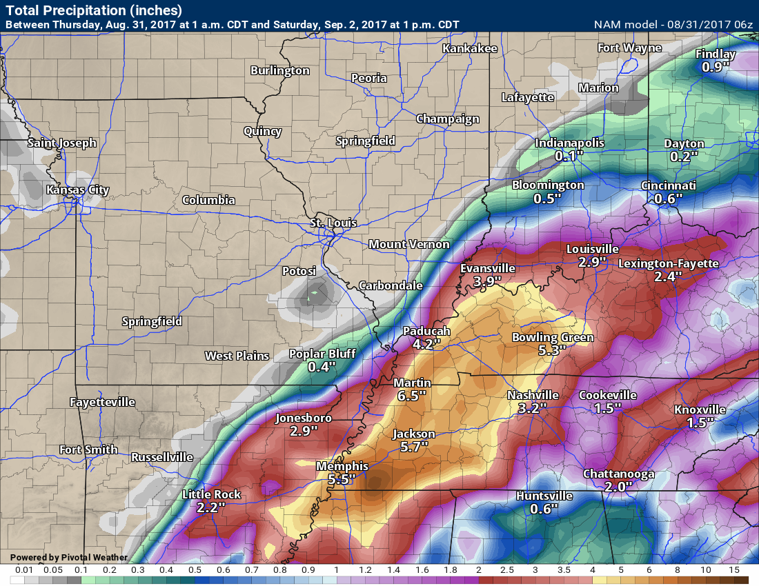
NAM 3K high resolution
Canadian
Click all images to enlarge
EC model
Click to enlarge

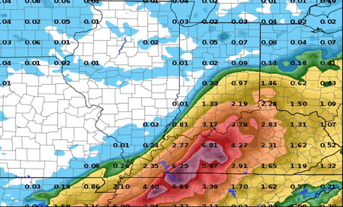
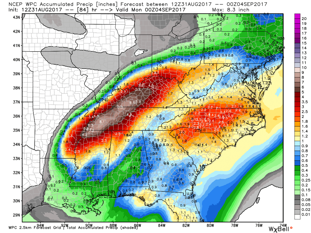
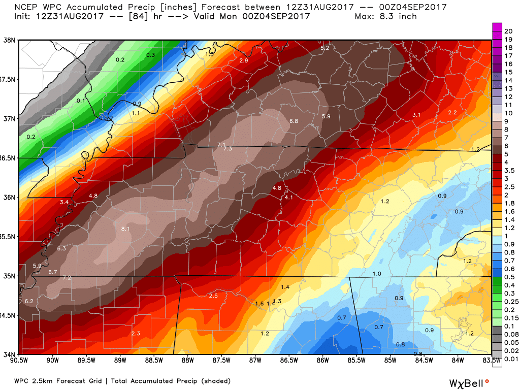
Let’s take a look at NOAA’s forecast from the WPC. Notice similarities with the model guidance. There is that band of heavier totals embedded in the system.
Regional view
Click to enlarge
Local view. Click to enlarge
Notice the SHARP gradient from almost no rain to several inches.
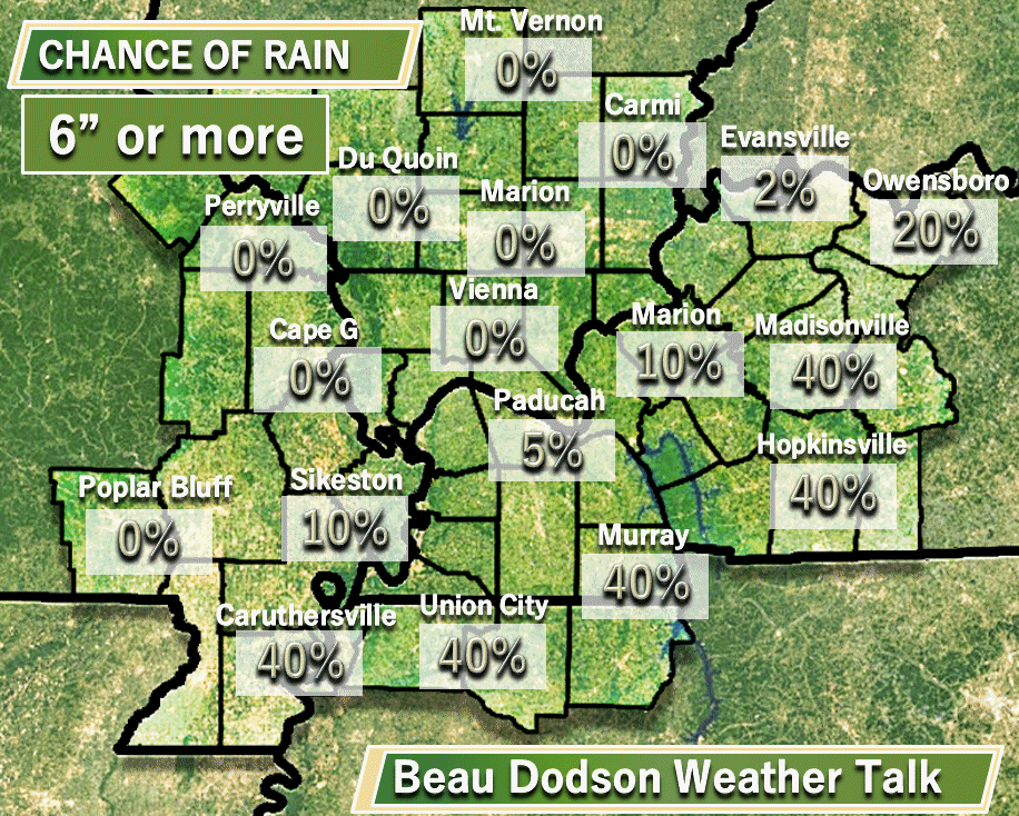
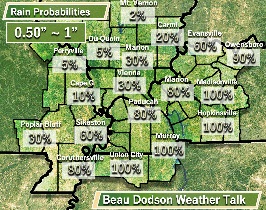
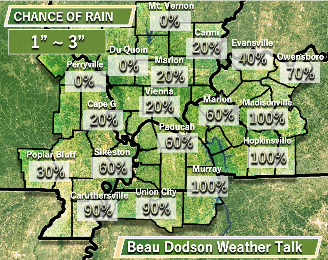
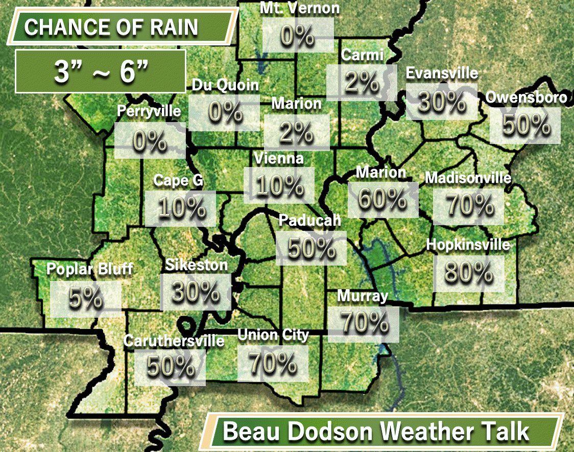
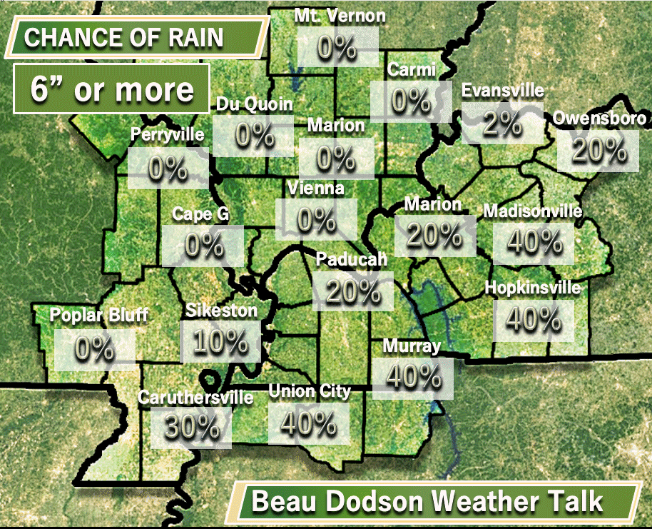
Here are my updated rainfall probability numbers.
I updated these at 7 am on Thursday morning.
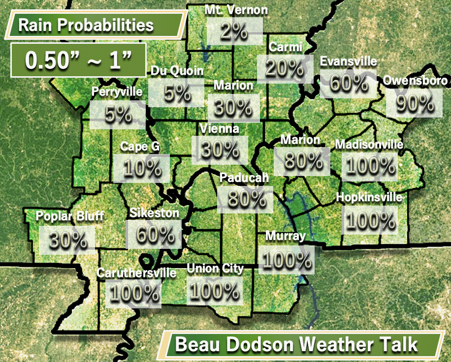
One-half inch to one inch of rain
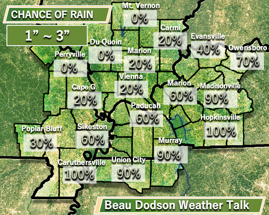
One to three inches of rain
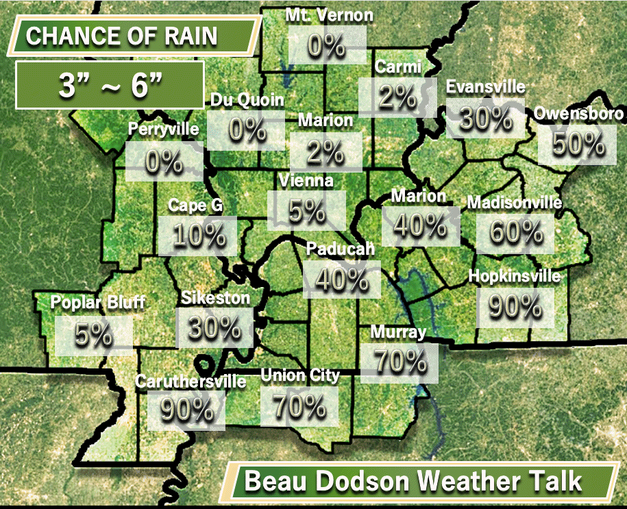
Three to six inches of rain. Lower confidence on these bigger numbers.
Greater than six inches of rain
Lower confidence on these big numbers. Still disagreement on the track of the center of Harvey.
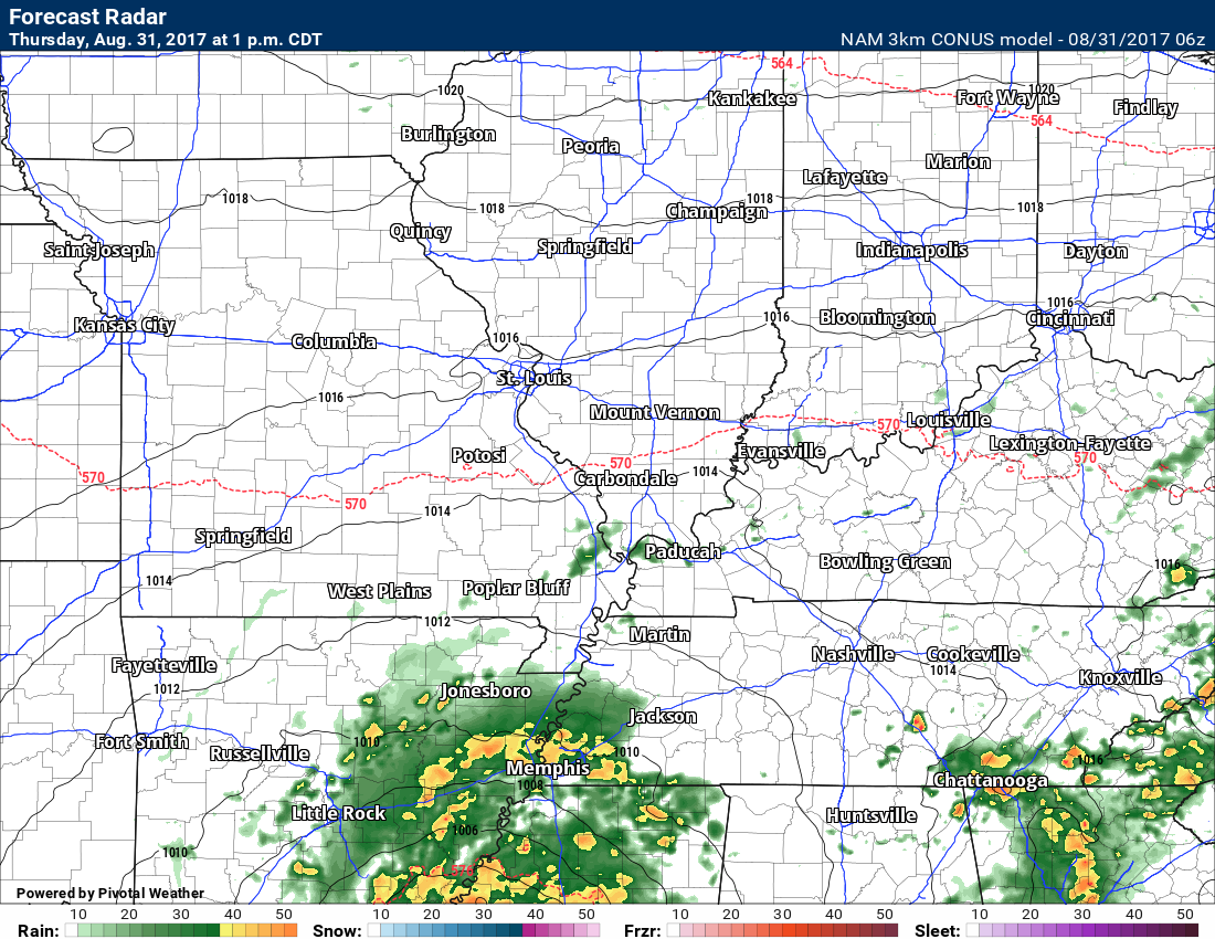
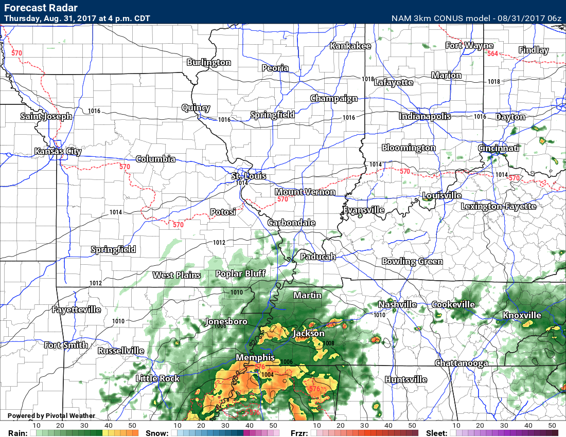
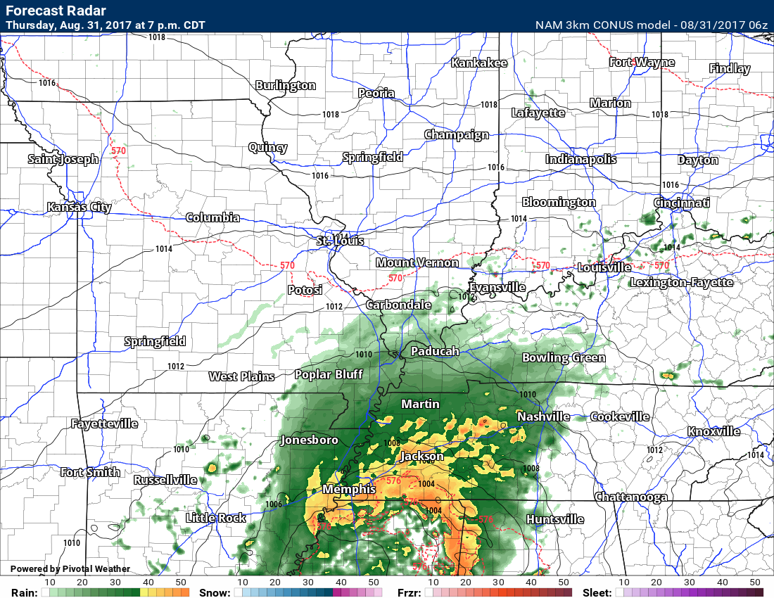
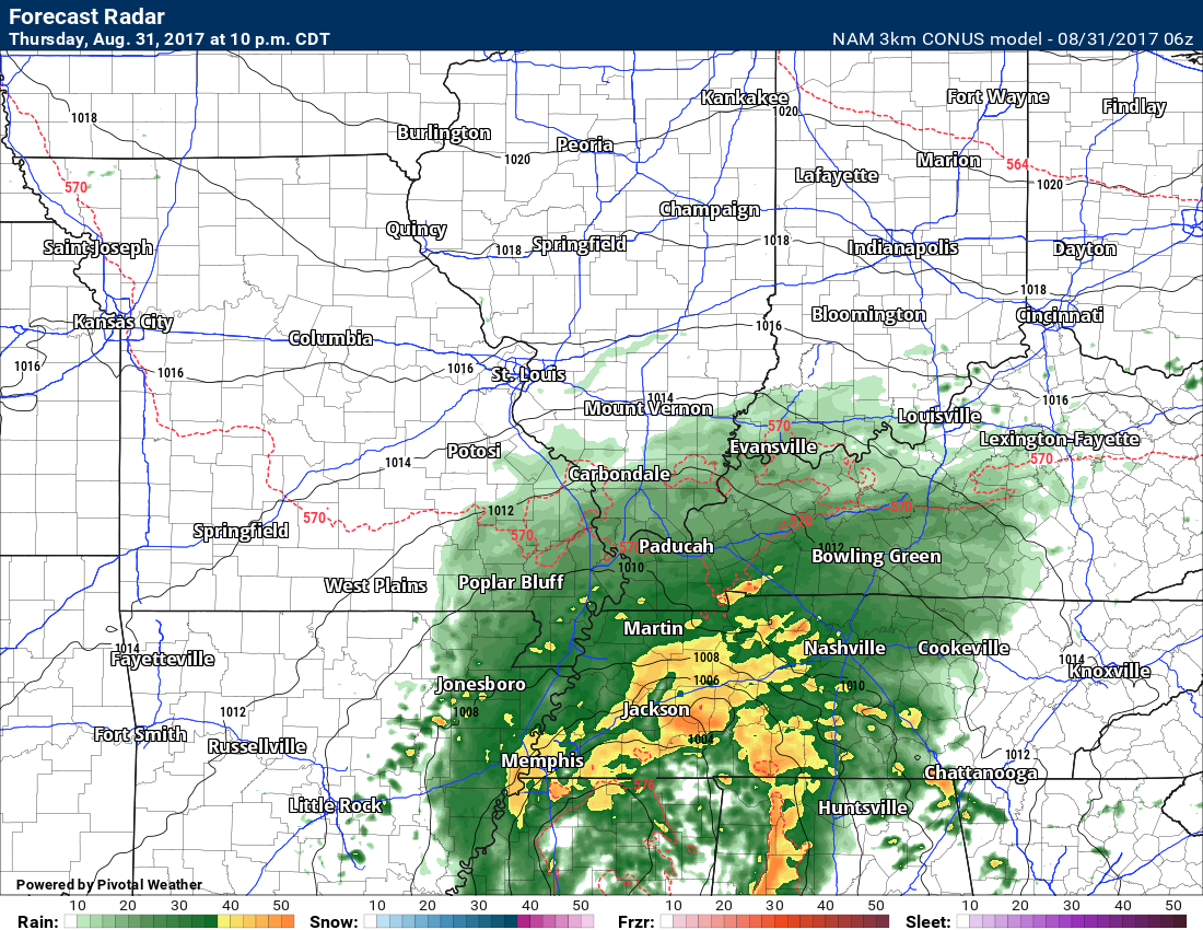
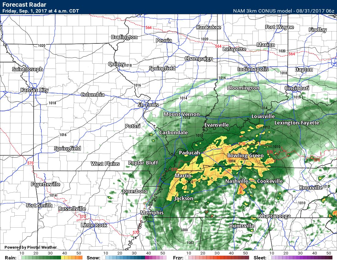
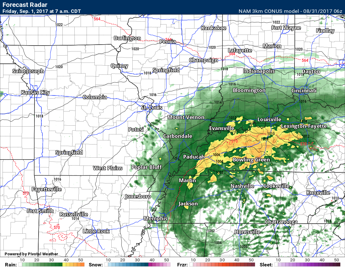
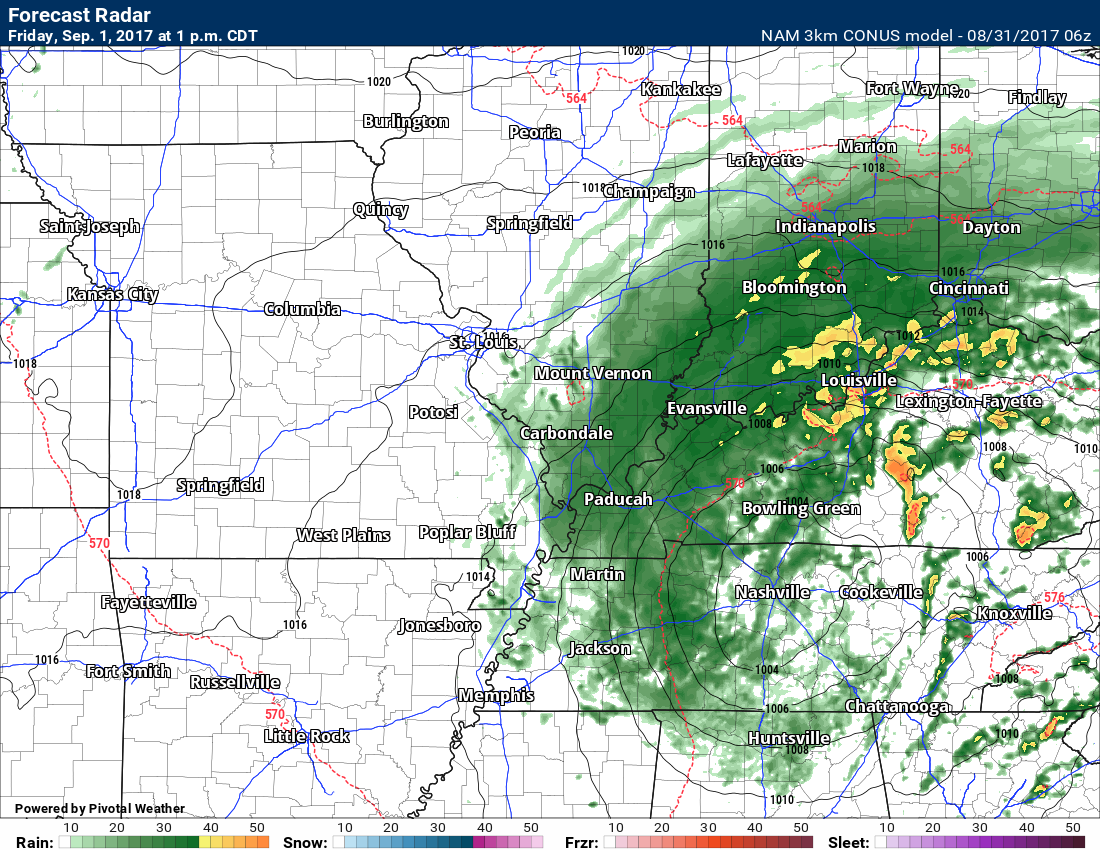
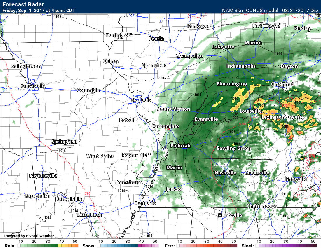
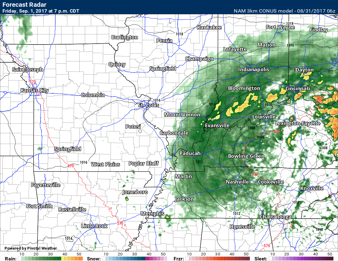
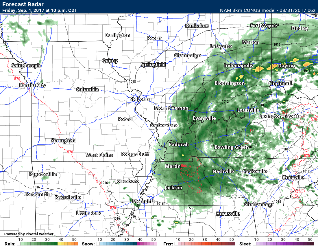
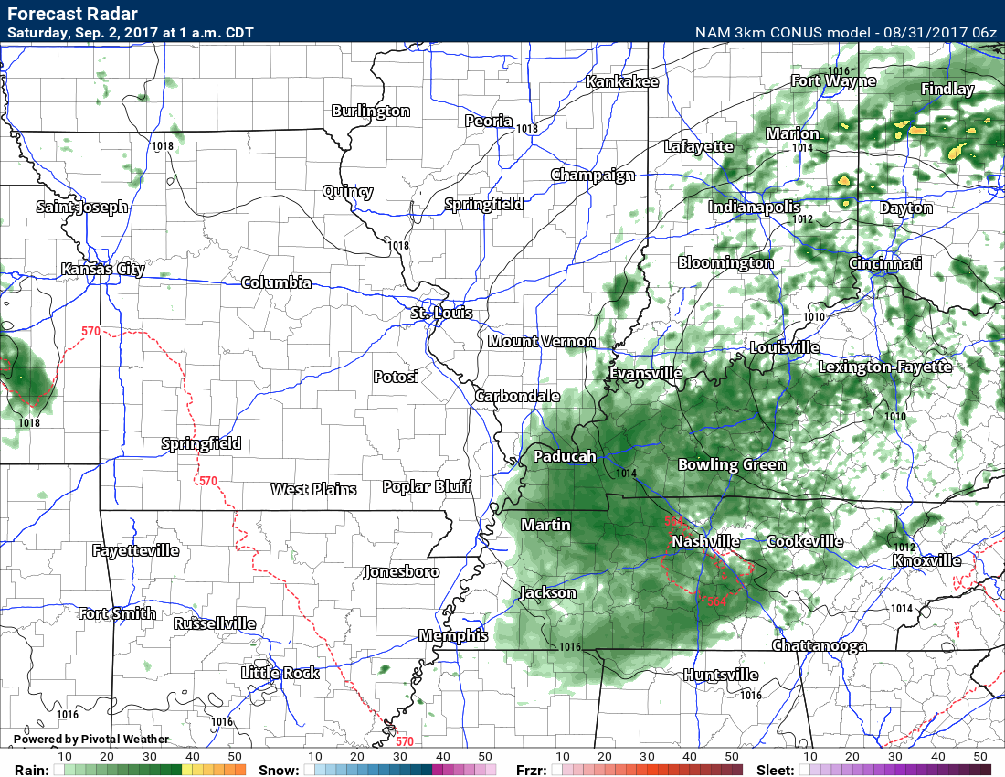
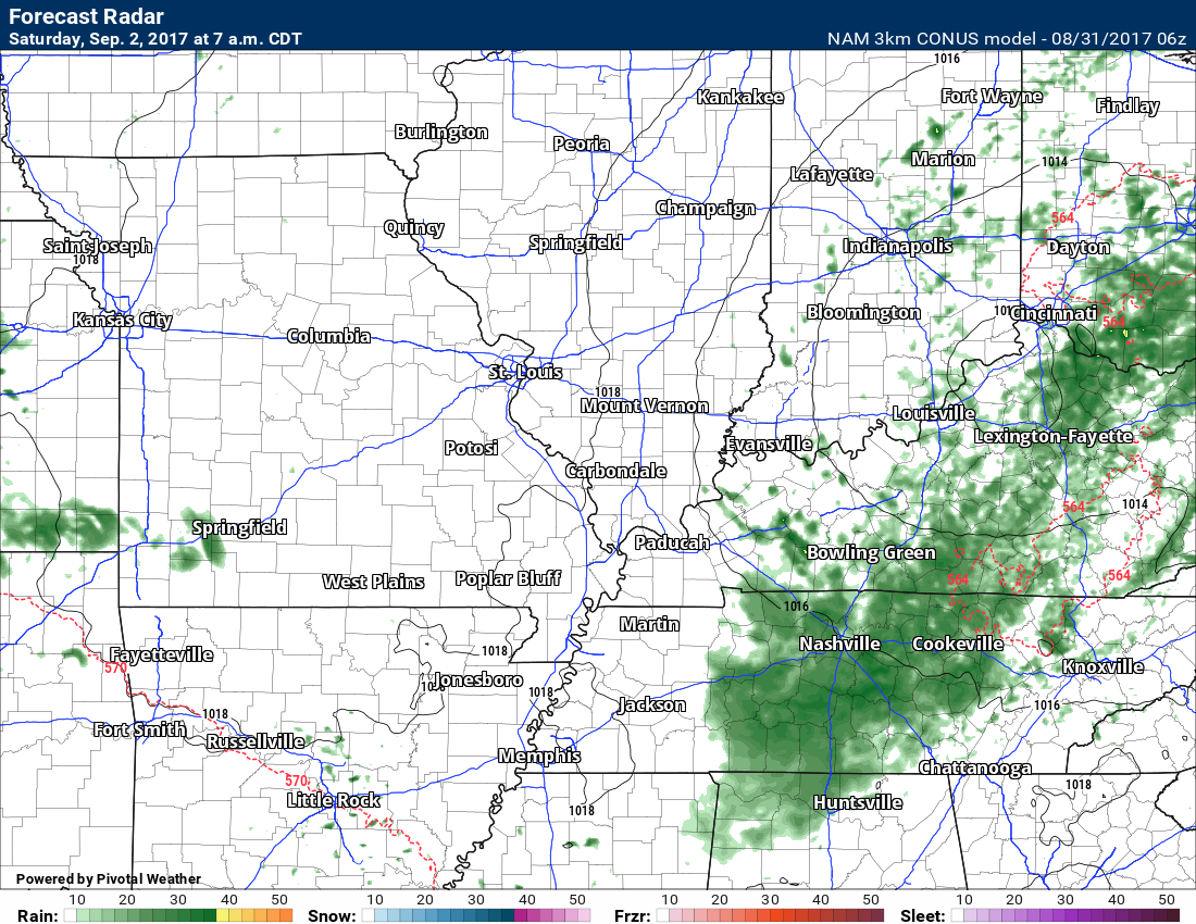
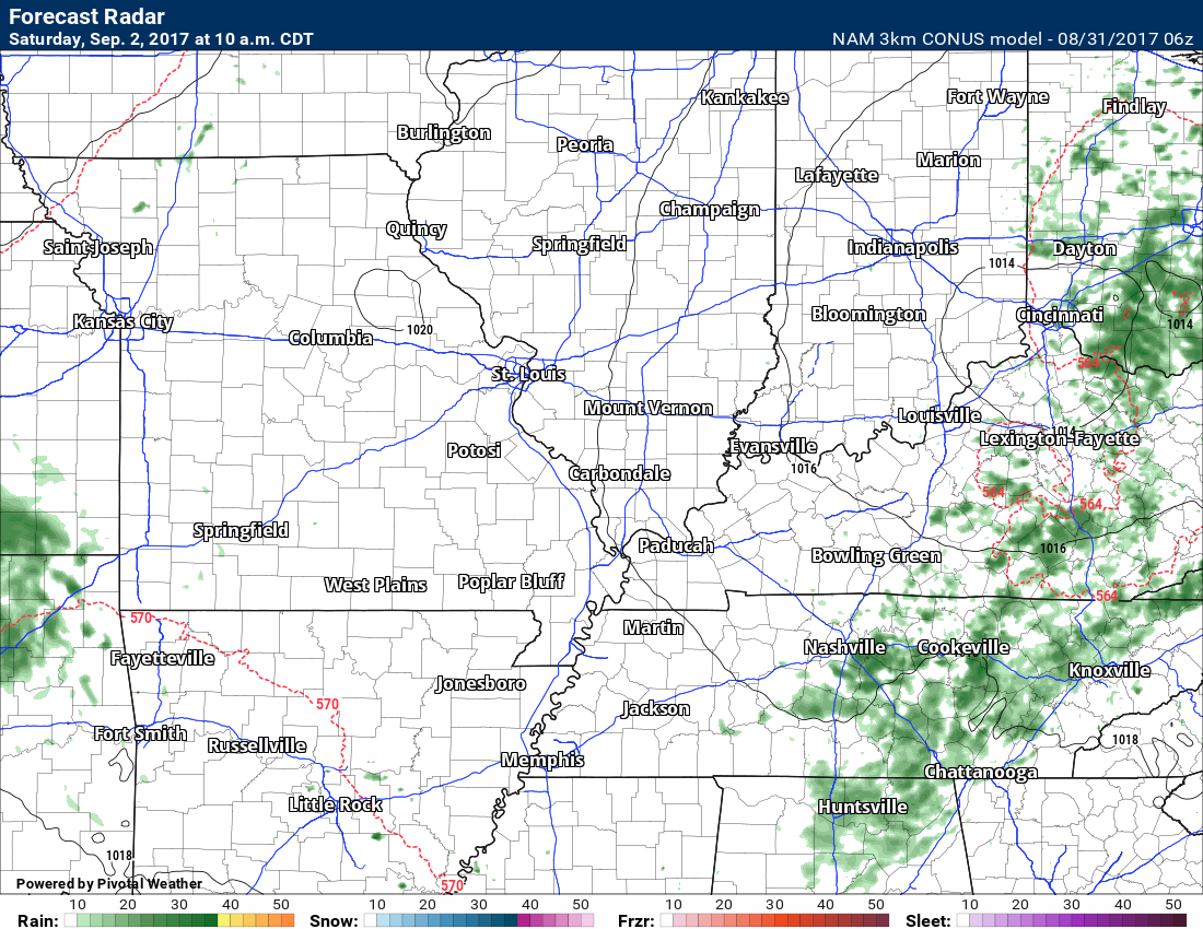
Future-cast radar.
What radar MIGHT look liked based on the 3K NAM guidance. Again, this is the models opinion. It may not be exact. Take the general idea from it.
Heaviest rain arrives Thursday night.
The models have slowed the departure of the system. Notice how rain lingers well into the overnight hours on Friday. This will need to be monitored as it is a change from previous thinking.
Several models are showing the potential slowdown in the northeast progression of the system.
It still appears that we will dry out by Saturday. I did keep shower chances in the forecast for portions of Kentucky early on Saturday. Otherwise, we should see the system pull away.
1 PM Thursday
4 PM Thursday. We can see the main rain band moving into the region from the south. It will move east/northeast overnight.
7 PM on Thursday.
10 PM Friday.
4 AM Friday
7 AM Friday
1 PM Friday
4 PM Friday
7 PM Friday
10 PM Friday
1 AM on Saturday
7 AM Saturday
10 AM on Saturday
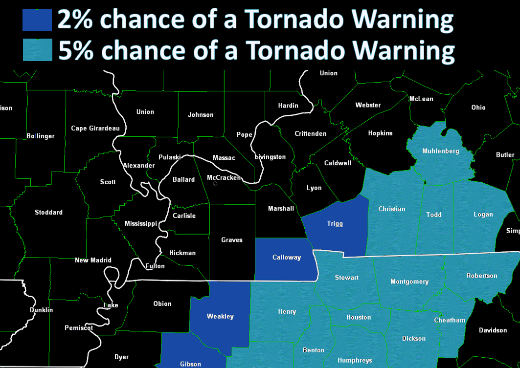
Tornado Outlook
Tornado risk graphics. Here are the probabilities for a tornado warning being issued. The greatest risk will be Thursday afternoon and Thursday night/early Friday morning.
Occasionally tropical systems can produce short lived tornadoes. Sometimes there is not a tornado warning. They can last seconds to a few minutes. They can occur without a thunderstorm present. In other words, they can occur in showers without lightning.
The overall tornado risk is fairly small, but certainly not zero. The greatest concern may end up in western Tennessee where a few tornadoes may occur. Less confidence on tornadoes in Kentucky.
Here is the morning Storm Prediction Center outlook. Green is a marginal risk. Yellow is a slight risk.
Click graphic to enlarge
Remember, a tornado watch means to keep updated on the weather. A warning means to seek shelter immediately. A warning means that radar or a spotter has reported a tornado and you should take cover.
What are the chances for a flood or flash flood warning?
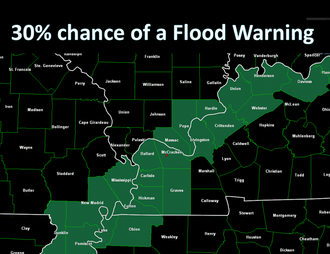
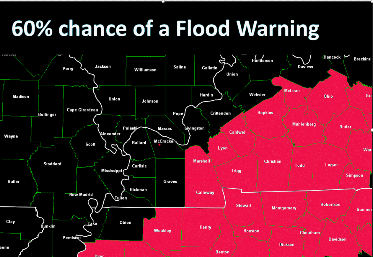
It is important to remember that historically the dying remnants of tropical systems have produced flash flooding in our region. Isolated pockets of extreme totals are not uncommon along the path of a dying system.
The heaviest rains will Harvey will be on the left and north side. That is because it is transitioning into an extra-tropical system

Choose the city nearest your location: Click this link


Videos can be viewed at this link. Long Range Video Update
If you believe you missed a video then you can also click the LIVE FEED link on the Weather Talk website. That page holds links for several days.
I can text you the videos, as well. Make sure you have text option FOUR turned on. That would be the Weather Extra text option. Sign up for the text messages at www.beaudodsonweather.com
.

.
This forecast update covers southern Illinois, southeast Missouri, western Kentucky. and northwest Tennessee.
.
The following link is for Weather Text subscribers. This is the page where short and long range video outlooks have been posted. The videos are being produced by a team of meteorologists. Some of the best in the region.
https://weathertalk.com/app/beaucast
.
August 31, 2017
Thursday Forecast Details
Forecast: Cloudy. Showers and thunderstorms becoming likely (mainly the southern half of the region). Precipitation would be moving northward out of Tennessee. Rain chances will be less from Poplar Bluff, Missouri towards Mt Vernon, Illinois. Northern counties have the least chance for precipitation.
Temperatures: MO ~ 78 to 84 IL ~ 78 to 84 KY ~ 76 to 82 TN ~ 76 to 82 Temperatures could be a bit warmer if we end up with a little more sunshine. Clouds are likely to keep temperatures down just a bit.
Winds: Variable winds at 8 to 14 mph with gusts to 18 mph. Winds increasing in the afternoon with gusts above 20 mph
What impacts are anticipated from the weather? Wet roadways. Isolated lightning. Small risk for tornadoes in Kentucky and Tennessee during the afternoon.
My confidence in the forecast verifying: High. This forecast should verify.
Is severe weather expected? Isolated tornado risk. This would mainly be for Tennessee and Kentucky.
The NWS defines severe weather as 58 mph winds or great, 1″ hail or larger, and/or tornadoes
What is the chance of precipitation? MO ~ 50% IL ~ 50% KY ~ 60% TN ~ 70%
Coverage of precipitation: Scattered to perhaps numerous. Increasing from the south towards the north.
Should I cancel my outdoor plans? Have a plan B in case rain moves into the region.
.
Thursday Night Forecast Details:
Forecast: Cloudy. Rain. Some lightning possible. Heavy rain likely over portions of the region (see graphics above). Monitor updates. Windy. High winds possible. Best chance for heavy rain will be the Missouri Bootheel into extreme southern Illinois and then Kentucky/Tennessee. Highest totals will be over Kentucky and Tennessee.
Temperatures: MO ~ 62 to 66 IL ~ 62 to 66 KY ~ 62 to 66 TN ~ 62 to 66
Winds: North and northeast at 15 to 25 mph becoming gusty. Gusts above 40 mph possible.
What impacts are anticipated from the weather? Wet roadways. Isolated lightning. Heavy rain. Isolated tornado risk. Flash flooding risk, esp for KY/TN. High winds possible.
My confidence in the forecast verifying: High. This forecast should verify.
Is severe weather expected? Isolated tornado risk. Flash flooding possible.
The NWS defines severe weather as 58 mph winds or great, 1″ hail or larger, and/or tornadoes
What is the chance of precipitation? MO ~ 70% IL ~ 80% KY ~ 100% TN ~ 100% (keep in mind that far northern counties will see lower rain chances vs southern half of the region)
Coverage of precipitation: Widespread.
Should I cancel my outdoor plans? Have a plan B
.
September 1, 2017
Friday Forecast Details
Forecast: Cloudy. Rain (lightning possible) likely over portions of southern Illinois, Kentucky, and Tennessee. Lesser chances as you move further west and north. Areas like Poplar Bluff, Missouri and Farmington, Missouri will likely see dry conditions as we move through the day. Windy with high winds possible. Cooler.
Temperatures: MO ~ 73 to 78 IL ~ 72 to 76 KY ~ 72 to 76 TN ~ 72 to 76
Winds: South and southeast at 15 mph with gusts to 40 mph with higher gusts possible
What impacts are anticipated from the weather? Wet roadways. Isolated lightning. Gusty winds. Flash flooding possible. Tornado risk should have dwindled.
My confidence in the forecast verifying: Medium. Some adjustments are possible.
Is severe weather expected? The tornado risk should have ended. Monitor updates and see risk charts above.
The NWS defines severe weather as 58 mph winds or great, 1″ hail or larger, and/or tornadoes
What is the chance of precipitation? MO ~ 60% IL ~ 70% KY ~ 70% TN ~ 70%
Coverage of precipitation: Numerous before 3 pm. Becoming more scattered late in the day. Rain lingers longer over the eastern half of the region.
Should I cancel my outdoor plans? Have a plan B
.
Friday Night Forecast Details:
Forecast: Cloudy. Rain possible over southeast Illinois, portions of western Kentucky, and northwest Tennessee. Rain should end from southwest to northeast. The system may slow a bit. This would keep rain chances lingering.
Temperatures: MO ~ 50 to 56 IL ~ 50 to 56 KY ~ 55 to 60 TN ~ 55 to 60
Winds: North winds at 8 to 16 mph with gusty winds, at times. Winds will depend on where the remnants of Harvey track. Winds should diminish through the night as Harvey pulls away.
What impacts are anticipated from the weather? Wet roadways. Watch for flooded roads.
My confidence in the forecast verifying: Medium. Some adjustments are possible.
Is severe weather expected? No.
The NWS defines severe weather as 58 mph winds or great, 1″ hail or larger, and/or tornadoes
What is the chance of precipitation? MO ~ 20% IL ~ 40% KY ~ 50% TN ~ 50%
Coverage of precipitation: Scattered to perhaps numerous early and then ending from southwest to northeast.
Should I cancel my outdoor plans? Have a plan B (esp southeast IL, Kentucky, and Tennessee)
.
September 2, 2017
Saturday Forecast Details
Forecast: Partly to perhaps mostly sunny. Morning clouds may linger over southeast Illinois, Kentucky, and Tennessee, Rain should have ended.
Temperatures: MO ~ 76 to 82 IL ~ 76 to 82 KY ~ 76 to 82 TN ~ 76 to 82
Winds: North and northwest winds at 6 to 12 mph. Gusts to 20 mph.
What impacts are anticipated from the weather? Most likely none.
My confidence in the forecast verifying: Medium. Some adjustments are possible.
Is severe weather expected? No
The NWS defines severe weather as 58 mph winds or great, 1″ hail or larger, and/or tornadoes
What is the chance of precipitation? MO ~ 10% IL ~ 10% KY ~ 20% TN ~ 10%
Coverage of precipitation: Rain should have ended.
Should I cancel my outdoor plans? No
.
Saturday Night Forecast Details:
Forecast: Clearing. Patchy fog possible.
Temperatures: MO ~ 54 to 58 IL ~ 52 to 56 KY ~ 54 to 58 TN ~ 54 to 58
Winds: Northwest at 5 to 10 mph
What impacts are anticipated from the weather? Patchy fog.
My confidence in the forecast verifying: Medium. Some adjustments are possible.
Is severe weather expected? No.
The NWS defines severe weather as 58 mph winds or great, 1″ hail or larger, and/or tornadoes
What is the chance of precipitation? MO ~ 0% IL ~ 0% KY ~ 0% TN ~ 0%
Coverage of precipitation: Most likely none
Should I cancel my outdoor plans? No
.
September 3, 2017
Sunday Forecast Details
Forecast: Mostly sunny. Perhaps some morning fog.
Temperatures: MO ~ 78 to 84 IL ~ 78 to 84 KY ~ 78 to 84 TN ~ 78 to 84
Winds: Variable winds at 4 to 8 mph with gusts to 12 mph
What impacts are anticipated from the weather? Patchy morning fog could reduce visibility.
My confidence in the forecast verifying: Medium. Some adjustments are possible.
Is severe weather expected? No
The NWS defines severe weather as 58 mph winds or great, 1″ hail or larger, and/or tornadoes
What is the chance of precipitation? MO ~ 0% IL ~ 0% KY ~ 0% TN ~ 0%
Coverage of precipitation: None
Should I cancel my outdoor plans? No
Sunday Night Forecast Details:
Forecast: Mostly clear. Patchy fog possible.
Temperatures: MO ~ 62 to 66 IL ~ 62 to 66 KY ~ 62 to 66 TN ~ 62 to 66
Winds: South and southwest winds at 4 to 8 mph
What impacts are anticipated from the weather? Most likely none.
My confidence in the forecast verifying: Medium. Some adjustments are possible
Is severe weather expected? No.
The NWS defines severe weather as 58 mph winds or great, 1″ hail or larger, and/or tornadoes
What is the chance of precipitation? MO ~ 0% IL ~ 0% KY ~ 0% TN ~ 0%
Coverage of precipitation: Most likely none
Should I cancel my outdoor plans? No
.
September 4, 2017
Monday Forecast Details
Forecast: Partly to mostly sunny. Mild.
Temperatures: MO ~ 82 to 86 IL ~ 82 to 86 KY ~ 82 to 86 TN ~ 82 to 86
Winds: South and southwest winds at 5 to 10 mph
What impacts are anticipated from the weather? Perhaps morning fog.
My confidence in the forecast verifying: Medium. Some adjustments are possible.
Is severe weather expected? No
The NWS defines severe weather as 58 mph winds or great, 1″ hail or larger, and/or tornadoes
What is the chance of precipitation? MO ~ 10% IL ~ 10% KY ~ 10% TN ~ 10%
Coverage of precipitation: None
Should I cancel my outdoor plans? No.
.
Monday Night Forecast Details:
Forecast: A few clouds. Patchy fog possible.
Temperatures: MO ~ 62 to 66 IL ~ 62 to 66 KY ~ 62 to 66 TN ~ 62 to 66
Winds: Variable at 5 to 10 mph
What impacts are anticipated from the weather? Patchy fog
My confidence in the forecast verifying: Medium
Is severe weather expected? No
The NWS defines severe weather as 58 mph winds or great, 1″ hail or larger, and/or tornadoes
What is the chance of precipitation? MO ~ 20% IL ~ 20% KY ~ 10% TN ~ 10%
Coverage of precipitation: None anticipated
Should I cancel my outdoor plans? No