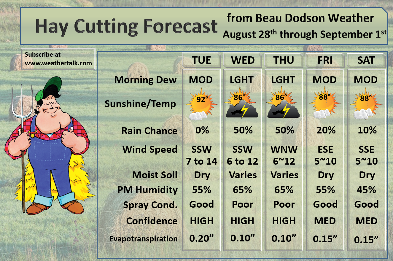
Click schedule for a larger view. Keep in mind, during active weather this schedule will change. There will be additional updates outside of what has been posted here.


We offer interactive local city view radars and regional radars.
If a radar does not update then try another one. If a radar does not appear to be refreshing then hit Ctrl F5. You may also try restarting your browser.

August 28, 2018
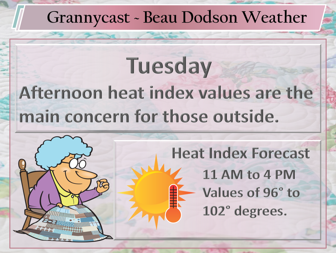
Tuesday Forecast Details
Forecast: Mostly sunny. A few cumulus clouds. Hot and muggy. Heat index 98 to 104.
Temperatures: MO ~ 90 to 94 IL ~ 90 to 94 KY ~ 90 to 94 TN ~ 90 to 94
What is the chance of precipitation? MO ~ 5% IL ~ 5% KY ~ 5% TN ~ 5%
Coverage of precipitation: Most likely none
Wind: South and southwest at 5 to 10 mph with gusts to 14 mph
What impacts are anticipated from the weather? High heat index values will make it uncomfortable.
My confidence in the forecast verifying: High
Is severe weather expected? No
The NWS defines severe weather as 58 mph wind or great, 1″ hail or larger, and/or tornadoes
Should I cancel my outdoor plans? No
UV Index: 8 to 10 High
Sunrise: 6:22 AM
Tuesday Night Forecast Details:
Forecast: Increasing clouds. Warm. Humid. A chance of late night thunderstorms over southeast Missouri and southern Illinois. Most areas will likely remain dry.
Temperatures: MO ~ 70 to 74 IL ~ 70 to 74 KY ~ 70 to 74 TN ~ 70 to 74
What is the chance of precipitation? MO ~ 30% IL ~ 20% KY ~ 10% TN ~ 10%
Coverage of precipitation: None to isolated.
Wind: South and southwest at 4 to 8 mph
What impacts are anticipated from the weather? Most likely none. Perhaps some isolated wet roads and lightning.
My confidence in the forecast verifying: Medium
Is severe weather expected? No
The NWS defines severe weather as 58 mph wind or great, 1″ hail or larger, and/or tornadoes
Should I cancel my outdoor plans? No
Sunset: 7:29 PM
Moonrise: 8:58 PM Waning Gibbous
Moonset: 8:14 AM
August 29, 2018
Wednesday Forecast Details
Forecast: Partly cloudy. Scattered thunderstorms likely. Some downpours possible. Warm and muggy. A strong thunderstorm possible with gusty wind and dime size hail.
Temperatures: MO ~ 85 to 90 IL ~ 85 to 88 KY ~ 86 to 88 TN ~ 86 to 90
What is the chance of precipitation? MO ~ 40% to 50% IL ~ 40% to 50% KY ~ 50% to 60% TN ~ 50% to 60%
Coverage of precipitation: Scattered to perhaps numerous
Wind: Southwest at 7 to 14 mph with gusts to 18
What impacts are anticipated from the weather? Wet roadways. Lightning. Some downpours possible.
My confidence in the forecast verifying: Medium
Is severe weather expected? There is a low end risk of damaging wind and nickel size hail. Monitor updates.
The NWS defines severe weather as 58 mph wind or great, 1″ hail or larger, and/or tornadoes
Should I cancel my outdoor plans? I would monitor radars and updates. There will be precipitation. Greatest coverage will likely be after 11 AM. PM hours will be peak heating and that is when thunderstorm activity should also peak.
UV Index: 6 to 8 Medium to high
Sunrise: 6:23 AM
Wednesday Night Forecast Details:
Forecast: Mostly cloudy. Showers and thunderstorms again possible. Warm and humid. The chances will shift further and further south as we move through Wednesday night.
Temperatures: MO ~ 68 to 74 IL ~ 68 to 74 KY ~ 70 to 72 TN ~ 70 to 74
What is the chance of precipitation? MO ~ 30% to 40% IL ~ 40% to 50% KY ~ 50% to 60% TN ~ 50% to 60%
Coverage of precipitation: Scattered to perhaps numerous
Wind: West and southwest at 6 to 12 mph
What impacts are anticipated from the weather? Wet roadways. Lightning. Some locally heavy rain possible.
My confidence in the forecast verifying: Medium
Is severe weather expected? Low end risk of strong winds and small hail (mainly early in the night)
The NWS defines severe weather as 58 mph wind or great, 1″ hail or larger, and/or tornadoes
Should I cancel my outdoor plans? No, but I would monitor radars and updates.
Sunset: 7:27 PM
Moonrise: 9:28 PM Waning Gibbous
Moonset: 9:12 AM
August 30, 2018
Thursday Forecast Details
Forecast: Mostly cloudy. The chance of showers and thunderstorms will continue to shift southward. Ending from north to south in the area.
Temperatures: MO ~ 80 to 85 IL ~ 80 to 85 KY ~ 80 to 85 TN ~ 80 to 85
What is the chance of precipitation? MO ~ 30% to 40% IL ~ 30% KY ~ 40% TN ~ 50%
Coverage of precipitation: Scattered (areas north of Cape Girardeau towards Harrisburg likely will be dry)
Wind: north and northeast wind behind the front at 4 to 8 mph. South and southwest winds ahead of the front.
What impacts are anticipated from the weather? Wet roadways. Lightning.
My confidence in the forecast verifying: Medium
Is severe weather expected? No, but monitor updates
The NWS defines severe weather as 58 mph wind or great, 1″ hail or larger, and/or tornadoes
Should I cancel my outdoor plans? No, but check radars and updates. Rain will be on radar.
UV Index: 6 to 8 Medium to high
Sunrise: 6:24 AM
Thursday Night Forecast Details:
Forecast: Partly cloudy. Perhaps an evening shower or thunderstorms in the Missouri Bootheel and along the Kentucky/Tennessee State line.
Temperatures: MO ~ 66 to 72 IL ~ 66 to 72 KY ~ 66 to 72 TN ~ 66 to 72
What is the chance of precipitation? MO ~ 20% IL ~ 20% KY ~ 30% TN ~ 30%
Coverage of precipitation: Scattered
Wind: East and northeast at 4 to 8 mph
What impacts are anticipated from the weather? None to wet roadways and lightning
My confidence in the forecast verifying: Medium
Is severe weather expected? No
The NWS defines severe weather as 58 mph wind or great, 1″ hail or larger, and/or tornadoes
Should I cancel my outdoor plans? No, but check radars
Sunset: 7:26 PM
Moonrise: 9:59 PM Waning Gibbous
Moonset: 10:11 AM
August 31, 2018
Friday Forecast Details
Forecast: Mostly sunny. A few clouds. Warm. Most likely dry. I will keep an eye on the placement of the cold front. It should stall to our south. If storms form Friday they would most likely be in the Missouri Bootheel, western Kentucky, and western Tennessee. The further south you travel the greater the chance of a storm or two. Most will remain dry.
Temperatures: MO ~ 85 to 88 IL ~ 85 to 88 KY ~ 85 to 88 TN ~ 85 to 88
What is the chance of precipitation? MO ~ 10% IL ~ 0% KY ~ 10% TN ~ 10%
Coverage of precipitation: None to isolated.
Wind: Southeast at 5 to 10 mph
What impacts are anticipated from the weather? None to isolated
My confidence in the forecast verifying: LOW
Is severe weather expected? No
The NWS defines severe weather as 58 mph wind or great, 1″ hail or larger, and/or tornadoes
Should I cancel my outdoor plans? No, but check radars
UV Index: 8 to 10 High
Sunrise: 6:25 AM
Friday Night Forecast Details:
Forecast: Mostly clear. A few clouds from time to time. Warm. Patchy fog.
Temperatures: MO ~ 66 to 74 IL ~ 66 to 72 KY ~ 68 to 74 TN ~ 70 to 74
What is the chance of precipitation? MO ~ 10% IL ~ 10% KY ~ 10% TN ~ 10%
Coverage of precipitation: None to isolated
Wind: Southeast at 5 to 10 mph
What impacts are anticipated from the weather? Most likely none. Perhaps isolated wet roadways and isolated lightning.
My confidence in the forecast verifying: Medium
Is severe weather expected? No
The NWS defines severe weather as 58 mph wind or great, 1″ hail or larger, and/or tornadoes
Should I cancel my outdoor plans? No, but check radars
Sunset: 7:25 PM
Moonrise: 10:33 PM Waning Gibbous
Moonset: 11:11 AM
September 1, 2018
Saturday Forecast Details
Forecast: Partly sunny. Warm. Humid. An isolated thunderstorm possible.
Temperatures: MO ~ 85 to 90 IL ~ 85 to 90 KY ~ 85 to 90 TN ~ 85 to 90
What is the chance of precipitation? MO ~ 20% IL ~ 20% KY ~ 20% TN ~ 20%
Coverage of precipitation: None to isolated. Most areas should remain dry.
Wind: Variable at 6 to 12 mph
What impacts are anticipated from the weather? None to perhaps isolated wet roadways and isolated lightning.
My confidence in the forecast verifying: Medium
Is severe weather expected? No
The NWS defines severe weather as 58 mph wind or great, 1″ hail or larger, and/or tornadoes
Should I cancel my outdoor plans? No, but check radars
UV Index: 8 to 10 High
Sunrise: 6:26 AM
Saturday Night Forecast Details:
Forecast: Partly cloudy. Warm. Humid. Isolated showers and thunderstorms possible. Patchy fog.
Temperatures: MO ~ 68 to 74 IL ~ 68 to 74 KY ~ 68 to 74 TN ~ 68 to 74
What is the chance of precipitation? MO ~ 20% IL ~ 20% KY ~ 20% TN ~ 20%
Coverage of precipitation: Isolated
Wind: South and southwest at 5 to 10 mph
What impacts are anticipated from the weather? Isolated wet roadways and lightning
My confidence in the forecast verifying: Medium
Is severe weather expected? No
The NWS defines severe weather as 58 mph wind or great, 1″ hail or larger, and/or tornadoes
Should I cancel my outdoor plans? No, but check radars
Sunset: 7:24 PM
Moonrise: 11:10 PM Waning Gibbous
Moonset: 12:16 PM
September 2, 2018
Sunday Forecast Details
Forecast: Partly cloudy. Warm. A chance of a widely scattered shower or thunderstorm.
Temperatures: MO ~ 85 to 90 IL ~ 85 to 90 KY ~ 85 to 90 TN ~ 85 to 90
What is the chance of precipitation? MO ~ 20% IL ~ 20% KY ~ 20% TN ~ 20%
Coverage of precipitation: Widely scattered
Wind: Southeast and south at 6 to 12 mph
What impacts are anticipated from the weather? A few wet roadways and lightning
My confidence in the forecast verifying: LOW
Is severe weather expected? No
The NWS defines severe weather as 58 mph wind or great, 1″ hail or larger, and/or tornadoes
Should I cancel my outdoor plans? No, but check radars
UV Index: 8 to 10 Medium to high
Sunrise: 6:27 AM
Sunday Night Forecast Details:
Forecast: Partly cloudy. An isolated thunderstorm possible. Patchy fog.
Temperatures: MO ~ 66 to 72 IL ~ 66 to 72 KY ~ 66 to 72 TN ~ 66 to 72
What is the chance of precipitation? MO ~ 20% IL ~ 20% KY ~ 20% TN ~ 20%
Coverage of precipitation: Isolated
Wind: South and southwest at 5 to 10 mph
What impacts are anticipated from the weather? Isolated wet roadways. Lightning.
My confidence in the forecast verifying: Medium
Is severe weather expected? No
The NWS defines severe weather as 58 mph wind or great, 1″ hail or larger, and/or tornadoes
Should I cancel my outdoor plans? No, but check radars
Sunset: 7:22 PM
Moonrise: 11:52 PM Waning Gibbous
Moonset: 1:19 PM
September 3, 2018
Labor Day
Monday Forecast Details
Forecast: Mostly sunny. Warm. Humid. An isolated thunderstorm possible.
Temperatures: MO ~ 86 to 92 IL ~ 86 to 92 KY ~ 86 to 92 TN ~ 88 to 92
What is the chance of precipitation? MO ~ 20% IL ~ 20% KY ~ 20% TN ~ 20%
Coverage of precipitation: Isolated
Wind: South and southwest at 4 to 8 mph
What impacts are anticipated from the weather? A few wet roadways and lightning
My confidence in the forecast verifying: Medium
Is severe weather expected? No
The NWS defines severe weather as 58 mph wind or great, 1″ hail or larger, and/or tornadoes
Should I cancel my outdoor plans? No, but check radars
UV Index: 8 to 10 Medium to high
Sunrise: 6:26 AM
Monday Night Forecast Details:
Forecast: Partly cloudy. A chance of an isolated shower or thunderstorm. Warm. Patchy fog.
Temperatures: MO ~ 66 to 72 IL ~ 66 to 72 KY ~ 66 to 72 TN ~ 66 to 72
What is the chance of precipitation? MO ~ 20% IL ~ 20% KY ~ 20% TN ~ 20%
Coverage of precipitation: Widely scattered
Wind: Southwest at 4 to 8 mph
What impacts are anticipated from the weather? A few wet roads and lightning.
My confidence in the forecast verifying: Medium
Is severe weather expected? No
The NWS defines severe weather as 58 mph wind or great, 1″ hail or larger, and/or tornadoes
Should I cancel my outdoor plans? No, but check radars
Sunset: 7:21 PM
Moonrise: 11:59 PM Last Quarter
Moonset: 2:24 PM
September 4, 2018
Tuesday Forecast Details
Forecast: Mostly sunny. Warm. Humid. A slight chance of a thunderstorm.
Temperatures: MO ~ 86 to 92 IL ~ 85 to 90 KY ~ 86 to 92 TN ~ 86 to 92
What is the chance of precipitation? MO ~ 20% IL ~ 20% KY ~ 20% TN ~ 20%
Coverage of precipitation:
Wind:
What impacts are anticipated from the weather? Wet roadways. Lightning.
My confidence in the forecast verifying: LOW
Is severe weather expected?
The NWS defines severe weather as 58 mph wind or great, 1″ hail or larger, and/or tornadoes
Should I cancel my outdoor plans? No, but check radars
UV Index: 8 to 10 High
Sunrise: 6:28 AM
Tuesday Night Forecast Details:
Forecast: Mostly clear. An isolated evening thunderstorm. Warm. Humid.
Temperatures: MO ~ 66 to 72 IL ~ 66 to 72 KY ~ 66 to 72 TN ~ 66 to 72
What is the chance of precipitation? MO ~ 20% IL ~ 20% KY ~ 20% TN ~ 20%
Coverage of precipitation:
Wind:
What impacts are anticipated from the weather? Wet roadways. Lightning.
My confidence in the forecast verifying: LOW
Is severe weather expected?
The NWS defines severe weather as 58 mph wind or great, 1″ hail or larger, and/or tornadoes
Should I cancel my outdoor plans? No, but check radars
Sunset: 7:19 PM
Moonrise: 12:42 AM Waning Crescent
Moonset: 3:27 PM
September 5, 2018
Wednesday Forecast Details
Forecast: Mostly sunny. Hot. Muggy. An isolated thunderstorm possible.
Temperatures: MO ~ 86 to 92 IL ~ 85 to 90 KY ~ 86 to 92 TN ~ 86 to 92
What is the chance of precipitation? MO ~ 20% IL ~ 20% KY ~ 20% TN ~ 20%
Coverage of precipitation:
Wind:
What impacts are anticipated from the weather? Wet roadways. Lightning.
My confidence in the forecast verifying: LOW
Is severe weather expected?
The NWS defines severe weather as 58 mph wind or great, 1″ hail or larger, and/or tornadoes
Should I cancel my outdoor plans?
UV Index: 8 to 10 High
Sunrise: 6:29 AM
Wednesday Night Forecast Details:
Forecast: Mostly clear with a few cumulus clouds. Warm. Humid. An isolated thunderstorm possible.
Temperatures: MO ~ 66 to 72 IL ~ 66 to 72 KY ~ 66 to 72 TN ~ 66 to 72
What is the chance of precipitation? MO ~ 20% IL ~ 20% KY ~ 20% TN ~ 20%
Coverage of precipitation:
Wind:
What impacts are anticipated from the weather? Wet roadways. Lightning.
My confidence in the forecast verifying: LOW
Is severe weather expected?
The NWS defines severe weather as 58 mph wind or great, 1″ hail or larger, and/or tornadoes
Should I cancel my outdoor plans? No, but check radars
Sunset: 7:18 PM
Moonrise: 1:38 AM Waning Crescent
Moonset: 4:27 PM
September 6, 2018
Thursday Forecast Details
Forecast: Partly sunny. A chance of a thunderstorm.
Temperatures: MO ~ 86 to 92 IL ~ 85 to 90 KY ~ 86 to 92 TN ~ 86 to 92
What is the chance of precipitation? MO ~ 20% IL ~ 20% KY ~ 20% TN ~ 20%
Coverage of precipitation:
Wind:
What impacts are anticipated from the weather? Wet roadways. Lightning.
My confidence in the forecast verifying: LOW
Is severe weather expected?
The NWS defines severe weather as 58 mph wind or great, 1″ hail or larger, and/or tornadoes
Should I cancel my outdoor plans? No, but check radars
UV Index: 8 to 10 High
Sunrise: 6:30 AM
Thursday Night Forecast Details:
Forecast: Partly cloudy. Warm. Humid. A thunderstorm possible.
Temperatures: MO ~ 70 to 74 IL ~ 70 to 74 KY ~ 70 to 74 TN ~ 70 to 74
What is the chance of precipitation? MO ~ 20% IL ~ 20% KY ~ 20% TN ~ 20%
Coverage of precipitation:
Wind:
What impacts are anticipated from the weather? Wet roadways. Lightning.
My confidence in the forecast verifying: LOW
Is severe weather expected?
The NWS defines severe weather as 58 mph wind or great, 1″ hail or larger, and/or tornadoes
Should I cancel my outdoor plans? No, but check radars
Sunset: 7:16 PM
Moonrise: 2:42 AM Waning Crescent
Moonset: 5:21 PM

Here is the latest WPC/NOAA rainfall outlook.
Keep in mind, this graphic won’t capture those locally heavy thunderstorms that we often have during the summer months. Those storms can easily drop an inch or more of rain in less than an hour.
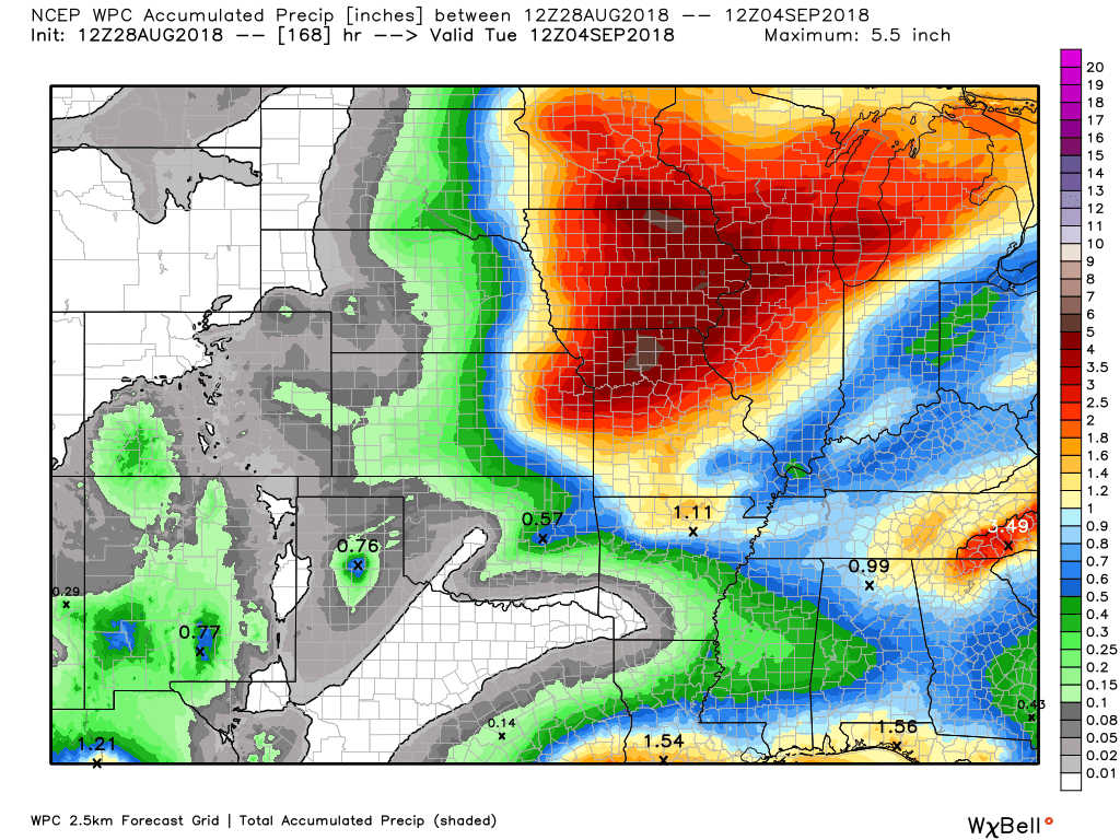
Here is the seven day rainfall forecast. This takes us into next Monday morning
Click to enlarge
.
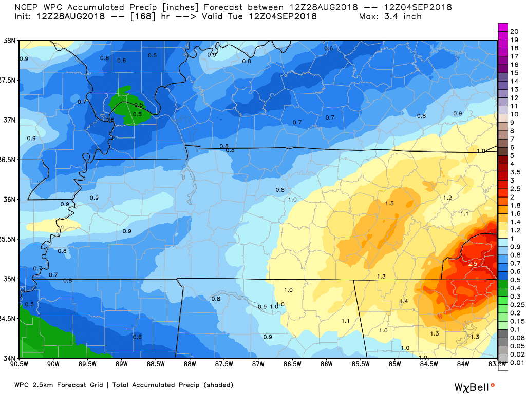
Here is the zoomed version of the above centered on southeast Missouri and southern Illinois
Notice the sharp gradient. This graphic takes us from now through 7 AM Tuesday
Click to enlarge the graphic

Zooming in on Kentucky and Tennessee.
This is through 7 AM Tuesday
Rain chances increase Wednesday and Thursday. Smaller chances Friday into Monday (many will remain dry during that time period)

We offer interactive local city live radars and regional radars.
If a radar does not update then try another one. If a radar does not appear to be refreshing then hit Ctrl F5 on your keyboard.
You may also try restarting your browser. The local city view radars also have clickable warnings.
During the winter months, you can track snow and ice by clicking the winterize button on the local city view interactive radars.

Questions? Broken links? Other questions?
You may email me at beaudodson@usawx.com

The National Weather Service defines a severe thunderstorm as one that produces quarter size hail or larger, 58 mph winds or greater, and/or a tornado.
Tuesday: Severe weather is not anticipated.
Wednesday through Friday: A cold front will approach the region from the north and west. This front will help produce showers and locally heavy thunderstorms. There is a non-zero severe weather risk Wednesday and Thursday. The main concern will be a few reports of strong winds. Pea to nickel size hail, as well.
The main concern will be Wednesday.
There will be plenty of moisture along the front. PWAT values (a measure of moisture in the atmosphere) will be high. That means locally heavy rain. Monitor updates.
The front may stall across Arkansas and Tennessee. The exact placement of where it stalls is important to our rain probabilities Friday into Monday. As long as we are north of the cold front then rain chances will be minimal Friday into Monday.
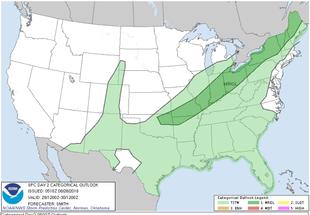
The Storm Prediction Center has placed us in a marginal (level one out of five) risk Wednesday. The dark green is the marginal risk of severe weather.
The scale runs from one to five. One being the lowest.
I can’t rule out a few reports of high winds and hail. Thursday will also need to be monitored. That risk will depend on how fast the cold front pushes southward.
The light green is sub-severe thunderstorms.
Summer thunderstorms can produce isolated microbursts.
microburst winds can exceed 50 mph.
What are microbursts?

Interactive live weather radar page. Choose the city nearest your location. If one of the cities does not work then try a nearby one. Click here.
National map of weather watches and warnings. Click here.
Storm Prediction Center. Click here.
Weather Prediction Center. Click here.

Live lightning data: Click here.

Interactive GOES R satellite. Track clouds. Click here.

Here are the latest local river stage forecast numbers Click Here.
Here are the latest lake stage forecast numbers for Kentucky Lake and Lake Barkley Click Here.

- Another hot and muggy day.
- Wednesday and Thursday will deliver increasing chances for scattered showers and locally heavy thunderstorms.
- Monitoring the potential of heavy rain.

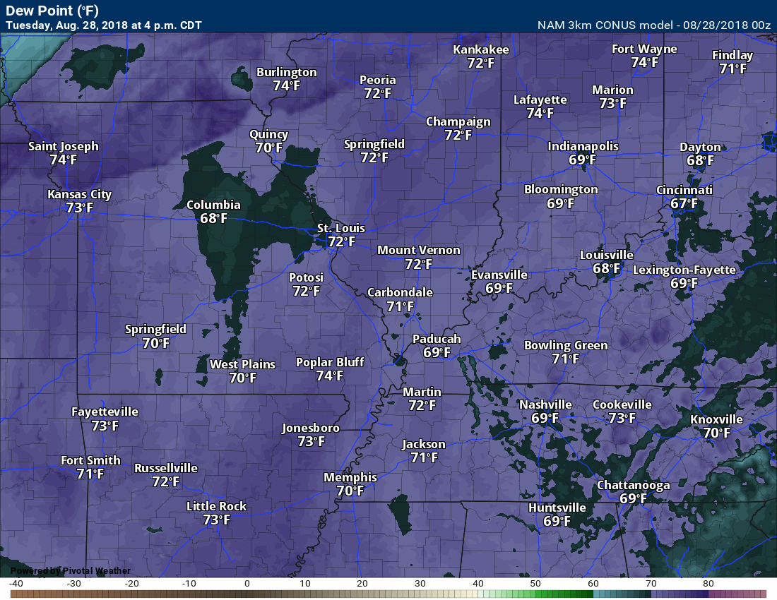
Today will feel like August! High temperatures will range from 88 to 94 degrees. Heat index values will range from 96 to 102 degrees. A hot day for the region.
Normal high temperatures are generally 88 to 92 degrees. We won’t be far off those numbers. It is the dew points that will make it feel miserable outside. Air you wear, as Jim Rasor likes to say.

Today’s dew point forecast
It appears thunderstorm chances today will be near zero. I am not anticipating precipitation.
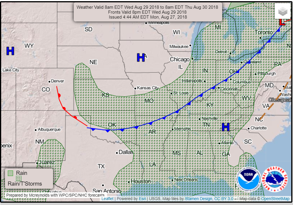
A cold front will push towards the region late tonight into Wednesday/Thursday. This front will be slow moving.
You can see that cold front here on the national weather map. This is valid on Wednesday at 8 AM.
The front will slowly sink into the region. Scattered showers and thunderstorms are possible in the hatched green zone. Some of the storms will be heavy.
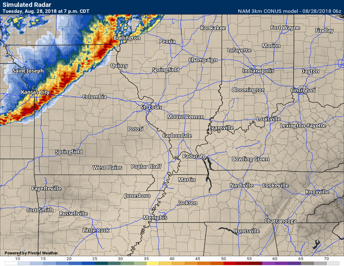
Here is the NAM 3K model future-cast radar. This is one more of several.
You can see how it develops a line of storms well to our northwest tonight and then redevelops it over our region Wednesday and Wednesday night.
This is one models opinion. The time stamp is on the upper left side of the animation.
Click to enlarge.
The front is forecast to stall over our region by Wednesday night and Thursday. Where it stalls will be key to precipitation chances.
PWAT values (a measure of moisture in the atmosphere) will be high. That means heavy rain (for some). Not everyone will experience the heavy rain. As always, during the summer months, there will be those will a lot more rain than others.
Watch on thsi PWAT animation how the higher values remain in our region into Thursday. Those along the front will need to monitor this.
Numbers above 1.7″ are considered high. Above 2″ would be extreme.

What are PWAT values?
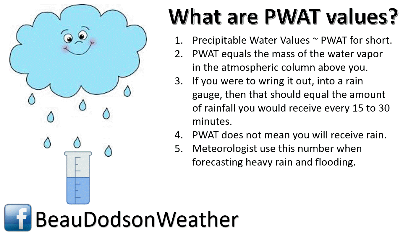
PWAT values are a clue when forecasting locally heavy rain. The longer the high numbers persist, the greater the chance of locally heavy downpours.
Generally, rainfall totals of 0.50″ to 1.00″ are anticipated. Some areas will pick up considerably more than that. I would not be surprised if a few locations picked up two or three inches of rain. This would mostly likely be where thunderstorms train over the same area.
As always, there will be those who miss out on the rain. That has been the case all summer.
What is training? Training is when thunderstorms repeatedly move over the same county. This can enhance rainfall. It can cause flash flooding, as well.
Although widespread flash flooding is not anticipated, there could be some pockets of problems. Monitor updates.
We have a non-zero severe weather threat, as well. What does that mean? It means that a few thunderstorms could produce damaging wind gusts and nickel size hail. Widespread severe weather appears unlikely.
Wind fields aloft, one ingredient in severe weather forecasting, will be weak. We will have some CAPE. CAPE is a measure of instability. High CAPE values are common during the summer months. It is the wind fields that are more important (at least in this case). Without strong wind fields the threat for severe weather will be kept to a minimum. Again, it only takes one severe thunderstorm to ruin a day. Monitor updates.
Heat index values today will top 96 degrees. This is what your body feels. This is important as it plays into heat related illnesses. It doesn’t just “sound” hotter. It actually is hotter to your body.
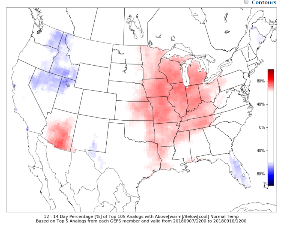
What are analogs?
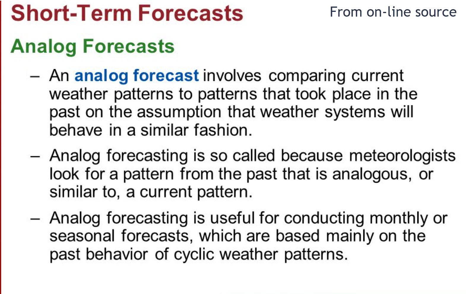
I like to use CIPS analogs. It does a great job when looking ahead.
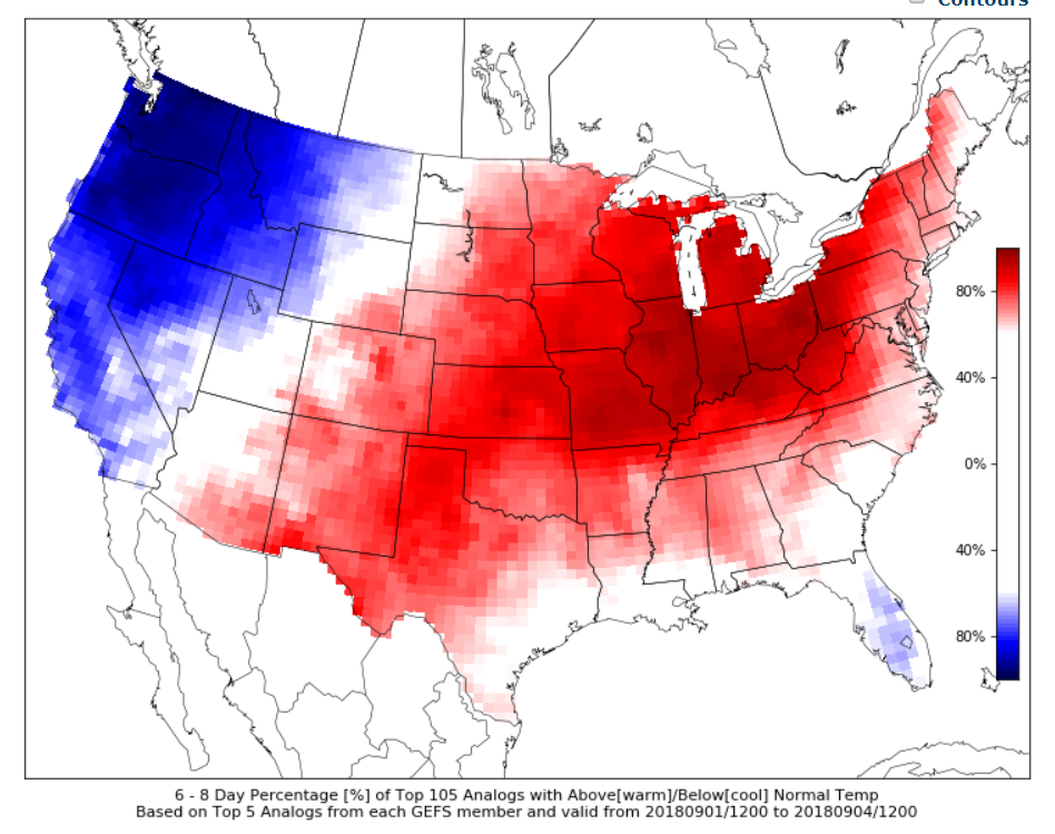
CIPS analogs show a strong signal for above normal temperatures September 1st through the 4th. This is a probability map of above or below normal temperatures.
Notice it is cooler in the west with a trough of low pressure. It is warmer in our region with the ridge of high pressure.
Click images to enlarge them.
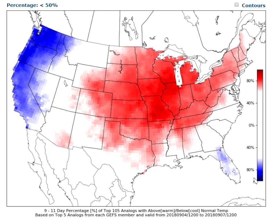
This next graphic is September 4th through the 7th
Lastly, this image represents September 7th through the 10th
The signal for warmer than normal temperatures grows weaker with time.
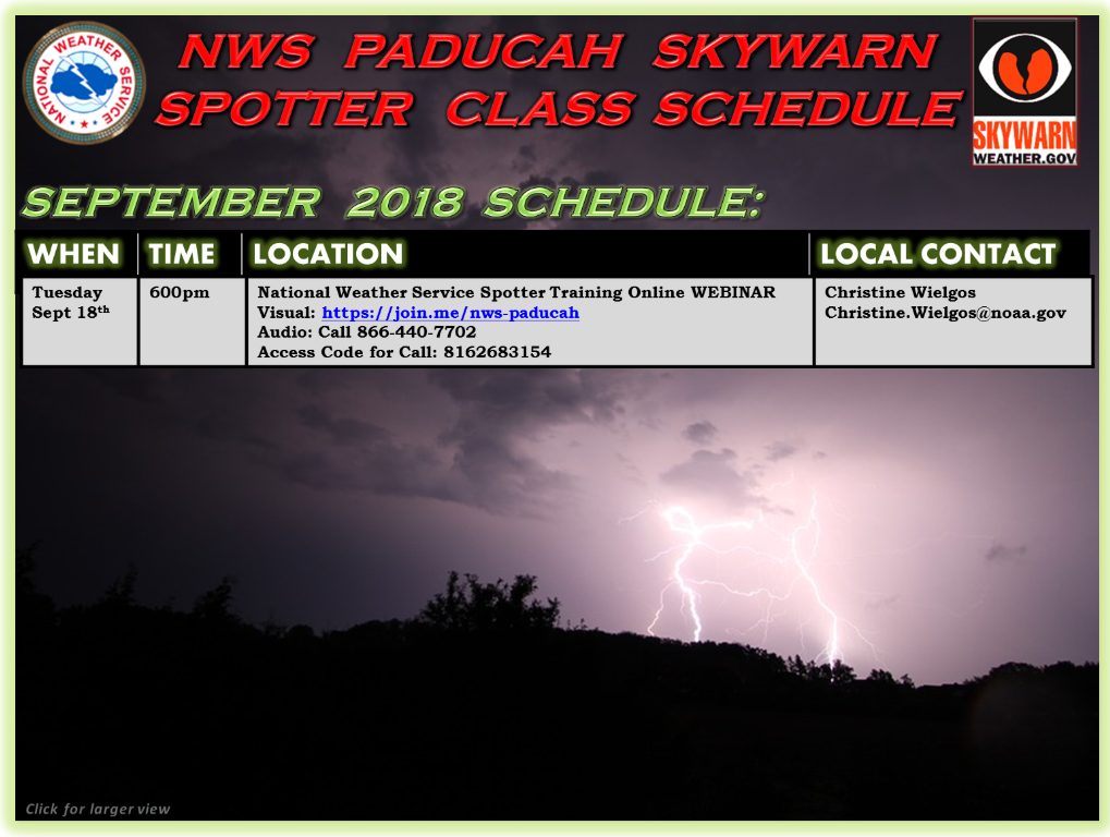
Spotter classes
![]()
Here is the preliminary fall outlook from the long range meteorology team.
Click to enlarge this graphic.
.
![]()
The September forecast has been updated.
These are bonus videos and maps for subscribers. I bring these to you from the BAMwx team. I pay them to help with videos.
The Ohio and Missouri Valley videos cover most of our area. They do not have a specific Tennessee Valley forecast but may add one in the future.
The long-range video is technical. Over time, you can learn a lot about meteorology from the long range video. Just keep in mind, it is a bit more technical.
NOTE: THESE ARE USUALLY NOT UPDATED ON SATURDAY OR SUNDAY.


![]()

I bring these to you from the BAMwx team. They are excellent long-range forecasters.
Remember, long-range outlooks are a bit of skill, understanding weather patterns, and luck combined. It is not an exact science.

This product is for subscribers.
Subscribe at www.weathertalk.com
Subscriber graphics can be viewed on this page CLICK HERE

This product is for subscribers.

Subscriber graphics can be viewed on this page CLICK HERE
![]()
.
First glance at fall!
Preliminary October precipitation outlook
Here is the preliminary November temperature and precipitation outlook
Preliminary November temperature outlook
Preliminary November precipitation outlook
.
![]()

![]()

A new weather podcast is now available! Weather Geeks (which you might remember is on The Weather Channel each Sunday)
To learn more visit their website. Click here.
![]()

WeatherBrains Episode 657
Dr. David Bodine from the Advanced Radar Research Center (see link in Web sites section) in Norman, OK, is building the prototype phased-array radar. He will join us from Japan where he is working for a few months with researchers at Kyoto University. This is definitely one of the longest connections for a Guest WeatherBrain in the history of the podcast – perhaps THE longest.
Other discussions in this weekly podcast include topics like:
- Extremes: 119 at Death Valley, CA, and 30 at 3 miles east of Agate, NE
- Severe storms occurring in Mid-South Region
- Tuesday severe possible western PA to northern VA
- Tropical Atlantic is quiet
- Astronomy Outlook with Tony Rice
- and more!
Link to web-site https://weatherbrains.com/
Previous episodes can be viewed by clicking here.
We offer interactive local city live radars and regional radars. If a radar does not update then try another one. If a radar does not appear to be refreshing then hit Ctrl F5. You may also try restarting your browser.
The local city view radars also have clickable warnings.
During the winter months, you can track snow and ice by clicking the winterize button on the local city view interactive radars.
You may email me at beaudodson@usawx.com
Find me on Facebook!

Find me on Twitter!

Did you know that a portion of your monthly subscription helps support local charity projects?
You can learn more about those projects by visiting the Shadow Angel Foundation website and the Beau Dodson News website.

I encourage subscribers to use the app vs regular text messaging. We have found text messaging to be delayed during severe weather. The app typically will receive the messages instantly. I recommend people have three to four methods of receiving their severe weather information.
Remember, my app and text alerts are hand typed and not computer generated. You are being given personal attention during significant weather events.
