We have some great sponsors for the Weather Talk Blog. Please let our sponsors know that you appreciate their support for the Weather Talk Blog.
Milner and Orr Funeral Home and Cremation Services located in Paducah, Kentucky and three other western Kentucky towns – at Milner and Orr they believe in families helping families. You can find Milner and Orr on Facebook, as well.
![]()
.

Wortham Dental Care located in Paducah, Kentucky. The gentle dentist. Mercury free dentistry. They also do safe Mercury removal. You can find Wortham Dental Care on Facebook, as well
.

Trover’s Equipment and Lawn Care – Family owned and operated! They are a dealer for Snapper, Simplicity, Snapper Pro, Bad Boy Mowers, and Intimidator Utility Vehicles. They are a Stihl and Dolmar power products dealer. They also are a dealer for Briggs & Stratton, Kohler gas & diesel engines, and Kawasaki engines. They service and repair just about any brand. You can find them on Facebook, as well
.

Visit their web-site here. Or, you can also visit their Facebook page.
.

Endrizzi’s Storm Shelters – For more information click here. Endrizzi Contracting and Landscaping can be found on Facebook, as well – click here
.
Are you looking for a full service insurance agency that writes homes, businesses, and vehicles in Illinois, Kentucky, and Tennessee. Call Gary’s office at 270.442.8234 for rates and plans to protect what matters to you!

Gary Eckelkamp’s web-site click the above banner or click here
.

This forecast update covers far southern Illinois, far southeast Missouri, and far western Kentucky. See the coverage map on the right side of the blog.
Remember that weather evolves. Check back frequently for updates, especially during active weather.
The forecast numbers below may vary a bit across the region. These are the averages.
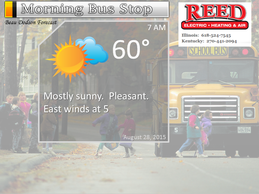
Thursday night – Some clouds. Pleasant.
Temperatures: Lows in the lower 60’s.
Winds: East and northeast winds at 5 mph.
My confidence in this part of the forecast verifying is high
Should I cancel my outdoor plans? No
Is severe weather expected? No
What is the chance for precipitation? 0%
What impact is expected? None
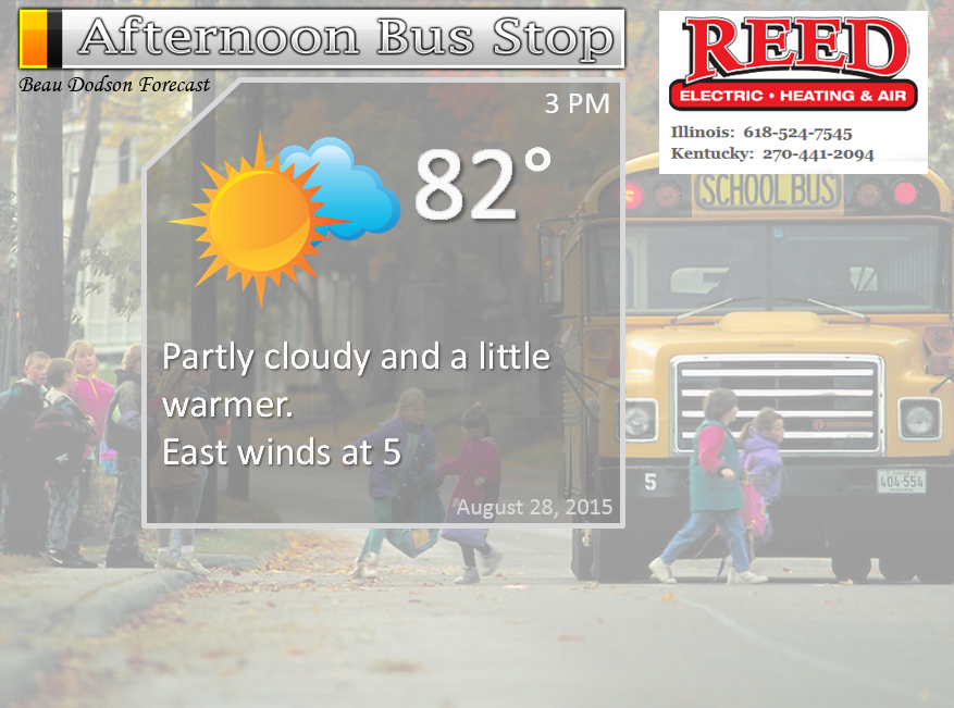
Friday – A mix of sun and clouds. Mild.
Temperatures: Highs in the lower to middle 80’s.
Winds: Southeast winds at 5-10 mph
My confidence in this part of the forecast verifying is high
Should I cancel my outdoor plans? No
Is severe weather expected? No
What is the chance for precipitation? 0%
What impact is expected? None
Friday night – Mostly clear. Perhaps a few clouds late at night.
Temperatures: Lows in the middle to upper 60’s
Winds: Southeast winds at 5-10 mph
My confidence in this part of the forecast verifying is high
Should I cancel my outdoor plans? No
Is severe weather expected? No
What is the chance for precipitation? 0%
What impact is expected? None
Saturday – Partly cloudy to perhaps mostly cloudy at times. A very small chance for a shower. Warmer than recent days.
Temperatures: Highs in the upper 80’s
Winds: Southerly winds at 10 mph
My confidence in this part of the forecast verifying is high
Should I cancel my outdoor plans? No
Is severe weather expected? No
What is the chance for precipitation? 10%
What impact is expected? None
Saturday night – Some clouds. A bit warmer than recent nights.
Temperatures: Lows in the middle to upper 60’s
Winds: Southwest winds at 5 mph.
My confidence in this part of the forecast verifying is high
Should I cancel my outdoor plans? No
Is severe weather expected? No
What is the chance for precipitation? 10%
What impact is expected? None
Sunday – Partly cloudy and warm. A chance for a couple of showers or thunderstorms.
Temperatures: Highs in the upper 80’s.
Winds: Southwest winds at 5-10 mph.
My confidence in this part of the forecast verifying is high
Should I cancel my outdoor plans? No
Is severe weather expected? No
What is the chance for precipitation? Less than 20%
What impact is expected? Not expecting any widespread concerns. If a storm forms then lightning is the main concern.
Sunday night – Partly cloudy and warmer. A slight chance for a shower or thunderstorm
Temperatures: Lows in the upper 60’s.
Winds: Southwest winds at 5-10 mph
My confidence in this part of the forecast verifying is high
Should I cancel my outdoor plans? No
Is severe weather expected? No
What is the chance for precipitation? 10%-20%
What impact is expected? Not expecting any widespread concerns. If a storm forms then lightning is the main concern.
Monday – Partly sunny and warmer. More humid, as well. A slight chance for a shower or thunderstorm.
Temperatures: Highs in the upper 80’s to lower 90’s.
Winds: Southwest winds at 5-10 mph
My confidence in this part of the forecast verifying is high
Should I cancel my outdoor plans? No
Is severe weather expected? No
What is the chance for precipitation? 10%-20%
What impact is expected? Not expecting any widespread concerns. If a storm forms then lightning is the main concern.
Monday night – Partly cloudy and mild.
Temperatures: Lows in the upper 60’s.
Winds: Southwest winds at 5-10 mph
My confidence in this part of the forecast verifying is high
Should I cancel my outdoor plans? No
Is severe weather expected? No
What is the chance for precipitation? 10%
What impact is expected? Not expecting any widespread concerns.
Tuesday – Partly sunny and warm.
Temperatures: Highs in the upper 80’s to lower 90’s
Winds: Southwest winds at 5-10 mph
My confidence in this part of the forecast verifying is high
Should I cancel my outdoor plans? No
Is severe weather expected? No
What is the chance for precipitation? 10%
What impact is expected? Not expecting any widespread concerns.
The School Bus Stop Forecast is sponsored by Reed Electric, Heating & Air in Metropolis, IL offers full electrical, heating, and air conditioning services, as well as automatic transfer generators. Our licensed and insured service technicians serve Southern Illinois and Western KY with 24 hour service. Free estimates available for all new installations!
Click their ad below to visit their web-site or click here reedelec.com

![]()
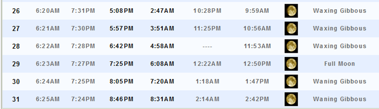
Sunrise and Sunset Times – Click Here


Don’t forget to check out the Southern Illinois Weather Observatory web-site for weather maps, tower cams, scanner feeds, radars, and much more! Click here

An explanation of what is happening in the atmosphere over the coming days…
Highlights
1. Just how many nice days can we chalk up on the board?
2. Small disturbance over the weekend. Believe most areas will remain dry with just a small shower chance.
3. Hot weather next week or just warm? Models are wavering a bit on high temperatures.
4. Update on Erika, for those who have concerns or interests in Florida or the East Coast
Imagine my surprise when I opened up the Farmers’ Almanac 2016 and was thumbing through the pages and saw my name! I had forgotten that they called me over a year ago to talk about the Weather Observatory! I never heard anything further from them and had forgotten all about it.
The article is between page 158 and 164. It is about Weather Geeks, Weather Observatories, and how you can learn more about storm spotting and observing the weather around you.
Be sure and pick up a copy!

Now, back to regularly scheduled programming.
A pattern like this could really make a weatherman lazy! We have had day after day of beautiful late summer weather. Days of below normal temperatures. Crisp nights. It really does feel more like September than August. Once again, no complaints!
The weather on Friday will be another nice one. A few degrees will be tacked onto the thermometer. But, nothing extreme.
We have a weak weather disturbance that will pass through the region over the weekend. I have placed rain chances at less than 20%. It does appear most everyone will remain dry.
Models attempt to pop a few more showers on Sunday night and Monday. But, again…mostly isolated (if they occur at all). I will continue to monitor all of the above. If shower chances appear to spike during any given time period then I will adjust the probabilities. For now, the above numbers seem appropriate. Most areas should remain dry through the weekend.
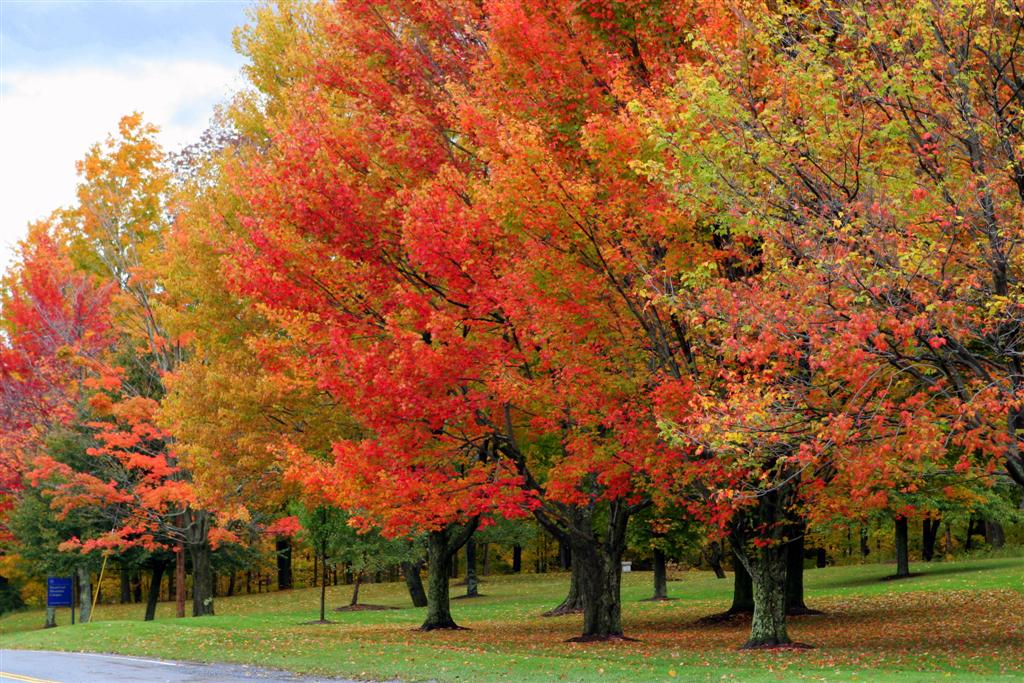
It won’t be much longer until we start seeing photographs like this (but, I won’t rush it)
I am forecasting a drier than normal September and a warmer than normal September. The one caveat of this could be a land falling tropical system that moves into our region. That can always mess us a drier than normal forecast. And, this is something I will be monitoring.
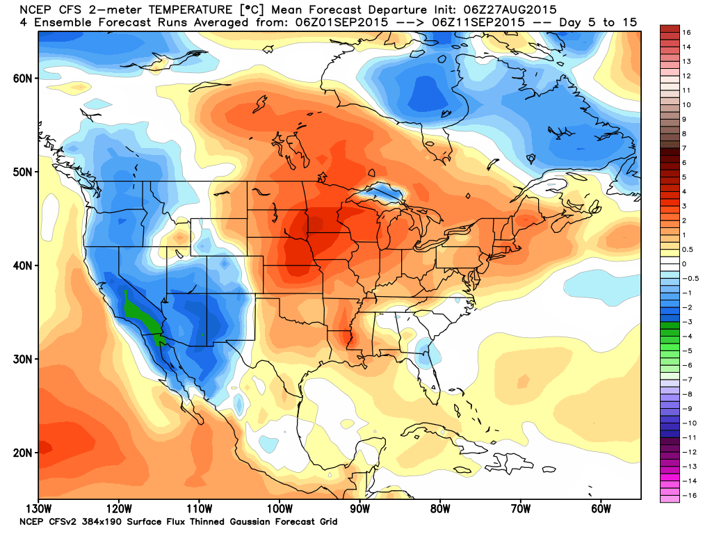
Let’s look at some long range maps for temperatures.
These colors represent above and/or below normal temperatures. Blue of course is below normal temperatures. Red of course would be above normal temperatures.
My September forecast has been that we would experience more normal to above normal temperature days vs below normal days.
And, this model is starting to agree with my assessment. This is for September 1st through September 11th. Mostly red in our region. That means temperatures through that time frame should average out above normal.
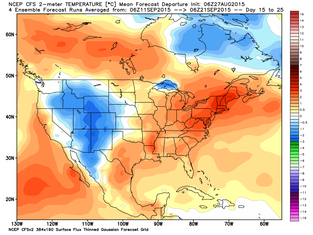
This next map is for the September 11th through September 21st time frame. Once again we see mostly above normal temperatures (when averaged out).
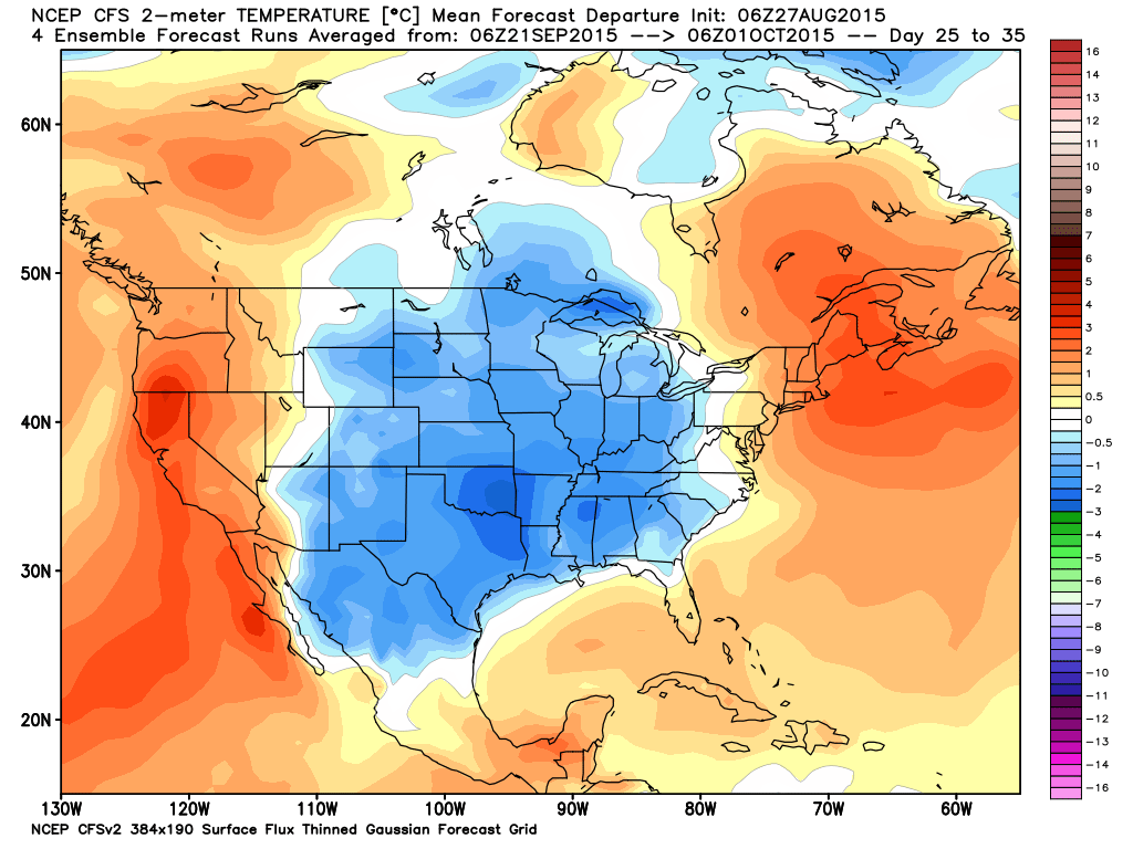
This last time frame is for the end of the month. Uh oh! Could we be looking at some early cold shots as we push into the end of the month and October? Certainly does appear possible. October could be colder than normal. We shall see.
Tropical Outlook:
Speaking of tropical systems. I continue to track Erika. I know some of you have trips to Florida and the East Coast. Weak flow could cause this system to stall off the southeast coast. Or, it could move into the southeast United States. Tough call this far out.
Tough call on intensity, as well. Models do not handle tropical storms and hurricane very well. Especially true when it comes to intensity.
Models range from a Florida hit to perhaps the Carolina’s. We still have several more days to track this system. Intensity might be key to where the storm makes a turn. Will it turn off the Florida Coast and just simply brush Florida? Good question and one that I can’t answer, yet.
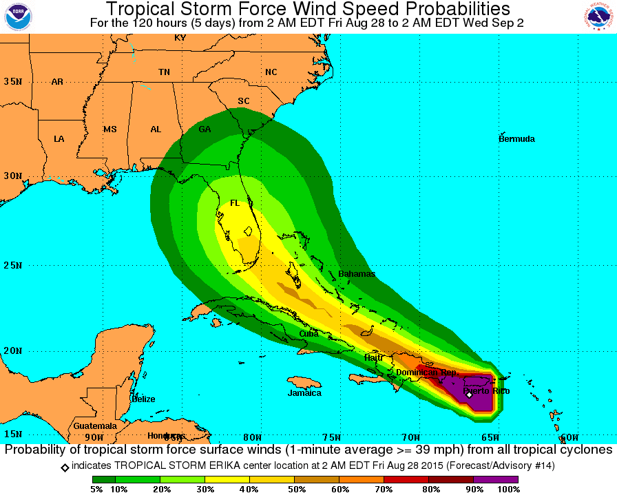
Tropical storms and hurricanes are extremely difficult to forecast days out. The National Hurricane Center uses a cone to give you an idea of where this system could track. The cone becomes broader as you extend out in time. The further out in time the larger the cone of uncertainty.
This system will be approaching Florida on Sunday night and Monday morning.
Here is the current track forecast cone.
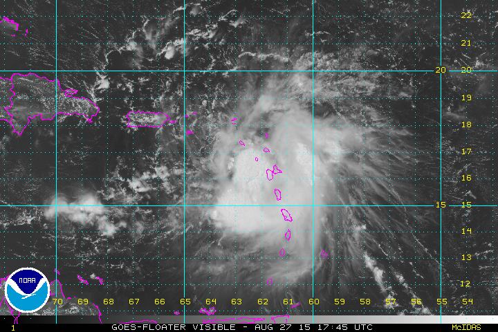
The satellite view of Erika shows a rather disorganized storm. But, I suspect this system could gain a lot of strength before all is said and done.
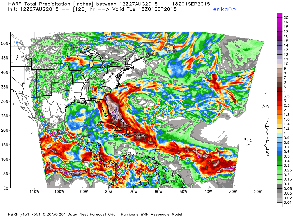
Here is one models opinion on the path of Erika and the rainfall from it. You can clearly see the track path.
Notice how this model believes the heaviest precipitation skirts the eastern coast of Florida. Time will tell.
The Paducah, Kentucky National Weather Service will be holding a couple of spotter classes in September.
Here is the information – click here
Radars
WEATHER RADAR PAGE – Click here —
Don’t forget to support our sponsors!

How much precipitation should we expect over the next few days?
No precipitation is forecast through Sunday. Very small chance for a shower on Saturday. Some data pop a few showers on Sunday into Monday. Believe the overall chances are very low. I will continue to monitor the trends.

Can we expect severe thunderstorms over the next 24 to 48 hours? Remember that a severe thunderstorm is defined as a thunderstorm that produces 58 mph winds or higher, quarter size hail or larger, and/or a tornado.
Thunderstorm threat level will be ZERO for Friday. Perhaps nearing a ONE by Saturday and Sunday when a couple of showers and storms might form, although the odds favor dry weather. Will continue to monitor.
.
Friday: Severe weather is not anticipated.
Saturday: Severe weather is not anticipated.
Sunday: Severe weather is not anticipated. Small chance for a thunderstorm.
Monday: Severe weather is not anticipated. Small chance for a thunderstorm.
Tuesday: Severe weather is not anticipated.
Wednesday: Severe weather is not anticipated

Once again, no major concerns! The beat goes on.

I also set up a storm tracking page with additional links (use during active weather for quick reference)
Storm Tracking Tool Page

Here are the current river stage forecasts. You can click your state and then the dot for your location. It will bring up the full forecast and hydrograph.
Click Here For River Stage Forecasts…
Here are some current forecast hydrographs. These will be updated each day with new information.


Smithland Lock and Dam

Paducah, Kentucky Forecast Stage

Cairo, Illinois

Cape Girardeau, Missouri
Current Temperatures Around The Local Area


We have regional radars and local city radars – if a radar does not seem to be updating then try another one. Occasional browsers need their cache cleared. You may also try restarting your browser. That usually fixes the problem. Occasionally we do have a radar go down. That is why I have duplicates. Thus, if one fails then try another one.
If you have any problems then please send me an email beaudodson@usawx.com
WEATHER RADAR PAGE – Click here —
We also have a new national interactive radar – you can view that radar by clicking here.
Local interactive city radars include St Louis, Mt Vernon, Evansville, Poplar Bluff, Cape Girardeau, Marion, Paducah, Hopkinsville, Memphis, Nashville, Dyersburg, and all of eastern Kentucky – these are interactive radars. Local city radars – click here
NOTE: Occasionally you will see ground clutter on the radar (these are false echoes). Normally they show up close to the radar sites – including Paducah.

Regional Radar – Click on radar to take you our full radar page.


Regional Radar

Live Lightning Data – zoom and pan: Click here
Live Lightning Data with sound (click the sound button on the left side of the page): Click here
I also set up a storm tracking page with additional links (use during active weather for quick reference)
Storm Tracking Tool Page
![]()
Current WARNINGS (a warning means take action now). Click on your county to drill down to the latest warning information. Keep in mind that there can be a 2-3 minute delay in the updated warning information.
I strongly encourage you to use a NOAA Weather Radio or warning cell phone app for the most up to date warning information. Nothing is faster than a NOAA weather radio.


Color shaded counties are under some type of watch, warning, advisory, or special weather statement. Click your county to view the latest information.

Missouri Warnings

Illinois Warnings

Kentucky Warnings

Here is the official 6-10 day and 8-14 day temperature and precipitation outlook. Check the date stamp at the top of each image (so you understand the time frame).
The forecast maps below are issued by the Weather Prediction Center (NOAA).


The latest 8-14 day temperature and precipitation outlook. Note the dates are at the top of the image. These maps DO NOT tell you how high or low temperatures or precipitation will be. They simply give you the probability as to whether temperatures or precipitation will be above or below normal.


Who do you trust for your weather information and who holds them accountable?
I have studied weather in our region since the late 1970’s. I have 37 years of experience in observing our regions weather patterns. My degree is in Broadcast Meteorology from Mississippi State University and an Associate of Science (AS). I am currently working on my Bachelor’s Degree in Geoscience. Just need to finish two Spanish classes!
I am a member of the American Meteorological Society. I am a NOAA Weather-Ready Nation Ambassador. And, I am the Meteorologist for McCracken County Emergency Management.
I own and operate the Southern Illinois Weather Observatory.
There is a lot of noise on the internet. A lot of weather maps are posted without explanation. Over time you should learn who to trust for your weather information.
My forecast philosophy is simple and straight forward.
- Communicate in simple terms
- To be as accurate as possible within a reasonable time frame before an event
- Interact with you on Twitter, Facebook, and the blog
- Minimize the “hype” that you might see on television or through other weather sources
- Push you towards utilizing wall-to-wall LOCAL TV coverage during severe weather events
I am a recipient of the Mark Trail Award, WPSD Six Who Make A Difference Award, Kentucky Colonel, and the Caesar J. Fiamma” Award from the American Red Cross. In 2009 I was presented with the Kentucky Office of Highway Safety Award. I was recognized by the Kentucky House of Representatives for my service to the State of Kentucky leading up to several winter storms and severe weather outbreaks.
If you click on the image below you can read the Kentucky House of Representatives Resolution.

I am also President of the Shadow Angel Foundation which serves portions of western Kentucky and southern Illinois.
Many of my graphics are from www.weatherbell.com – a great resource for weather data, model data, and more


You can sign up for my AWARE email by clicking here I typically send out AWARE emails before severe weather, winter storms, or other active weather situations. I do not email watches or warnings. The emails are a basic “heads up” concerning incoming weather conditions.