We have some great sponsors for the Weather Talk Blog. Please let our sponsors know that you appreciate their support for the Weather Talk Blog.
Milner and Orr Funeral Home and Cremation Services located in Paducah, Kentucky and three other western Kentucky towns – at Milner and Orr they believe in families helping families. You can find Milner and Orr on Facebook, as well.
![]()
.

Wortham Dental Care located in Paducah, Kentucky. The gentle dentist. Mercury free dentistry. They also do safe Mercury removal. You can find Wortham Dental Care on Facebook, as well
.

Trover’s Equipment and Lawn Care – Family owned and operated! They are a dealer for Snapper, Simplicity, Snapper Pro, Bad Boy Mowers, and Intimidator Utility Vehicles. They are a Stihl and Dolmar power products dealer. They also are a dealer for Briggs & Stratton, Kohler gas & diesel engines, and Kawasaki engines. They service and repair just about any brand. You can find them on Facebook, as well
.

Visit their web-site here. Or, you can also visit their Facebook page.
.

Endrizzi’s Storm Shelters – For more information click here. Endrizzi Contracting and Landscaping can be found on Facebook, as well – click here
.
Are you looking for a full service insurance agency that writes homes, businesses, and vehicles in Illinois, Kentucky, and Tennessee. Call Gary’s office at 270.442.8234 for rates and plans to protect what matters to you!

Gary Eckelkamp’s web-site click the above banner or click here
.

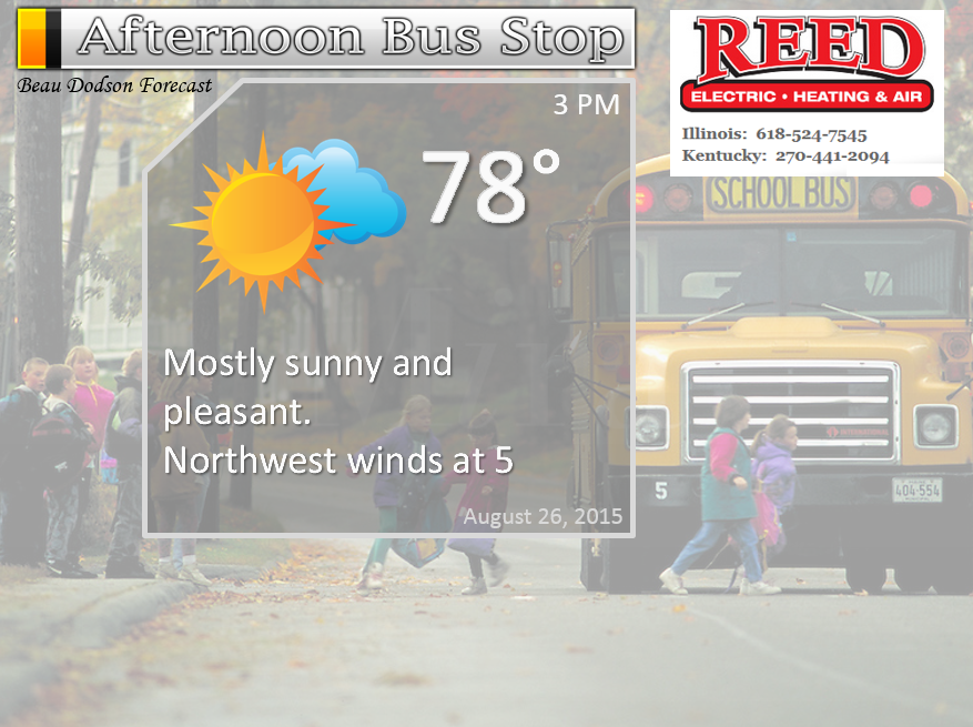
This forecast update covers far southern Illinois, far southeast Missouri, and far western Kentucky. See the coverage map on the right side of the blog.
Remember that weather evolves. Check back frequently for updates, especially during active weather.
The forecast numbers below may vary a bit across the region. These are the averages.
Tuesday night – Mostly clear and pleasant. Near record lows possible.
Temperatures: Lows in the middle to upper 50’s.
Winds: Northerly winds at 5 mph.
My confidence in this part of the forecast verifying is high
Should I cancel my outdoor plans? No
Is severe weather expected? No
What is the chance for precipitation? 0%
What impact is expected? None
Wednesday – Mostly sunny. Amazing weather for late August
Temperatures: Highs in the upper 70’s and lower 80’s.
Winds: Northerly winds at 5-10 mph
My confidence in this part of the forecast verifying is high
Should I cancel my outdoor plans? No
Is severe weather expected? No
What is the chance for precipitation? 0%
What impact is expected? None
Wednesday night – Mostly clear and pleasant.
Temperatures: Lows in the upper 50’s to lower 60’s.
Winds: Northerly winds at 5 mph.
My confidence in this part of the forecast verifying is high
Should I cancel my outdoor plans? No
Is severe weather expected? No
What is the chance for precipitation? 0%
What impact is expected? None
Thursday – Mostly sunny. Continued nice weather. Perhaps a little warmer.
Temperatures: Highs in the lower to middle 80’s.
Winds: Northeast winds at 5-10 mph
My confidence in this part of the forecast verifying is high
Should I cancel my outdoor plans? No
Is severe weather expected? No
What is the chance for precipitation? 0%
What impact is expected? None
Thursday night – Mostly clear and pleasant.
Temperatures: Lows in the 60’s.
Winds: Northeast winds at 5 mph.
My confidence in this part of the forecast verifying is high
Should I cancel my outdoor plans? No
Is severe weather expected? No
What is the chance for precipitation? 0%
What impact is expected? None
Friday – Perhaps an increase in clouds during the afternoon. Mild.
Temperatures: Highs in the lower to middle 80’s.
Winds: Southeast winds at 5-10 mph
My confidence in this part of the forecast verifying is high
Should I cancel my outdoor plans? No
Is severe weather expected? No
What is the chance for precipitation? 10%
What impact is expected? None
Saturday and Sunday – Small (10%-20%) chance for showers on Saturday. Otherwise, warmer. Highs in the middle to upper 80’s.
How next week? See details below.
I am still expecting September to deliver normal to below normal rainfall and above normal temperatures. We will see how it goes.

The School Bus Stop Forecast is sponsored by Reed Electric, Heating & Air in Metropolis, IL offers full electrical, heating, and air conditioning services, as well as automatic transfer generators. Our licensed and insured service technicians serve Southern Illinois and Western KY with 24 hour service. Free estimates available for all new installations!
Click their ad below to visit their web-site or click here reedelec.com

![]()
Sunrise and Sunset Times – Click Here


Don’t forget to check out the Southern Illinois Weather Observatory web-site for weather maps, tower cams, scanner feeds, radars, and much more! Click here

An explanation of what is happening in the atmosphere over the coming days…
Highlights
1. Another nice day on tap for the region
2. We will do it all over again on Thursday. Perhaps a couple of degrees warmer.
3. Watching a weak disturbance over the weekend
4. Hot next week? 90’s return?
Well, so far nobody has complained (to me at least) about these beautiful late summer temperatures. I would say we have done quite well in August. A couple of warm days, but nothing too intense.
It isn’t very often you experience an August of this nature.
We will do it all over again on Wednesday.
I am watching a disturbance for Friday night into Saturday. This is a system that is forecast to pass mainly to our north. If the current forecast track is accurate then we will likely remain mostly dry. I suppose if it tracks a little further south then we will have to think about 20%-30% rain chances for late Friday night into Saturday. Let’s continue to keep a weather eye on it.
A couple of weather maps from wright-weather.com The purple and pink represent rainfall.
You can see the area of low pressure to our northwest on Friday morning (near Omaha, Nebraska). More towards Nebraska and Iowa. Our region remains dry on Friday.
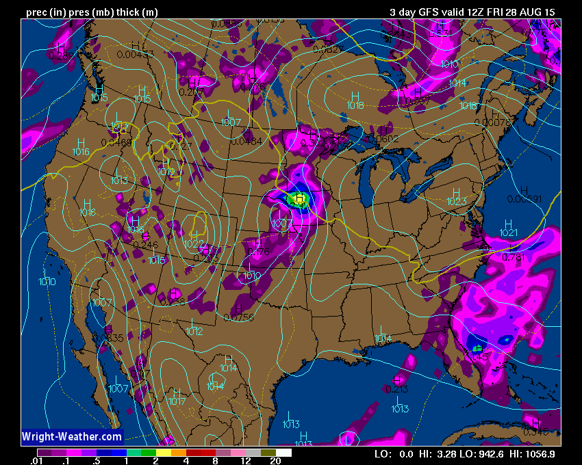
Then on Saturday you can see some attempt at a few showers over the Missouri Valley. Again, lower than normal confidence that it might rain in our region. I will keep an eye on it.

Perhaps a bigger story will be the return to heat next week (you didn’t think summer was over, did you). If everything goes as planned then we can expect several days in the 90’s between next Monday and Friday. A ridge of high pressure will attempt to build back into our region from the southwest. This is a ridge. A ridge in summer typically means hot weather (not talking about high pressure that dives in from Canada, like recent days).
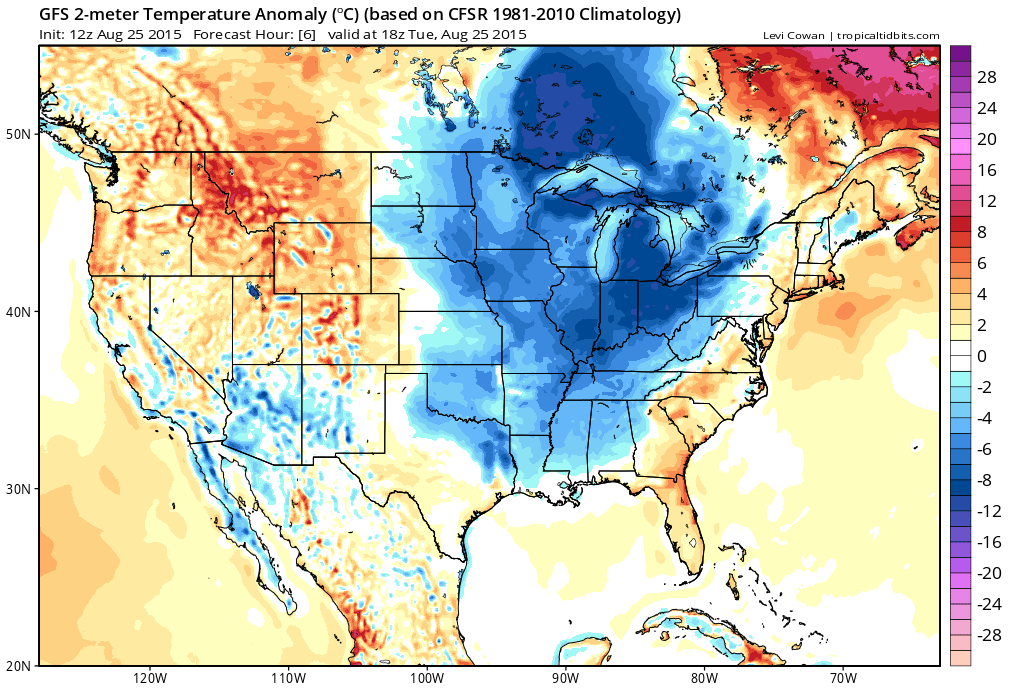
Let’s compare some anomaly maps. How much above or below normal will temperatures be. These are in Celsius.
This is the current map. Blue! That means below normal temperatures are occurring over our region.
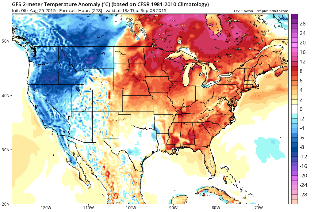
Let’s move ahead to next week. Ouch. If the models are correct then we will experience above normal temperatures next week. Lot of 90+ days possible.
This is basically a flip in the pattern, if true. Lot of orange and red. That equals bove normal temperatures.
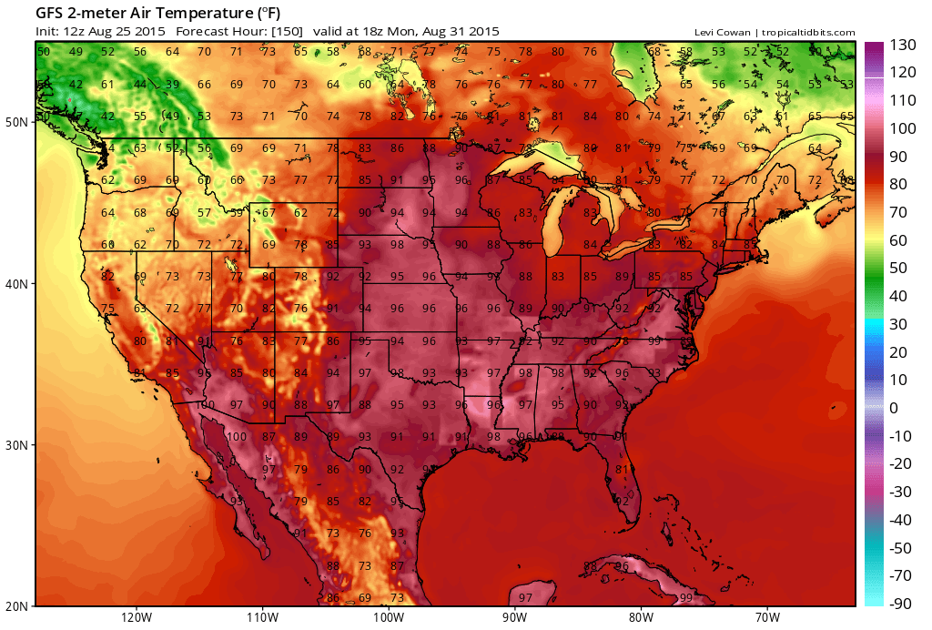
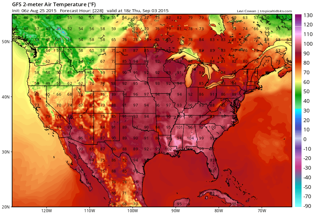
Let’s pick a few days and look at the high temperature forecast maps for next week.
This is for Monday of next week (August 31st). Click images for larger view size.
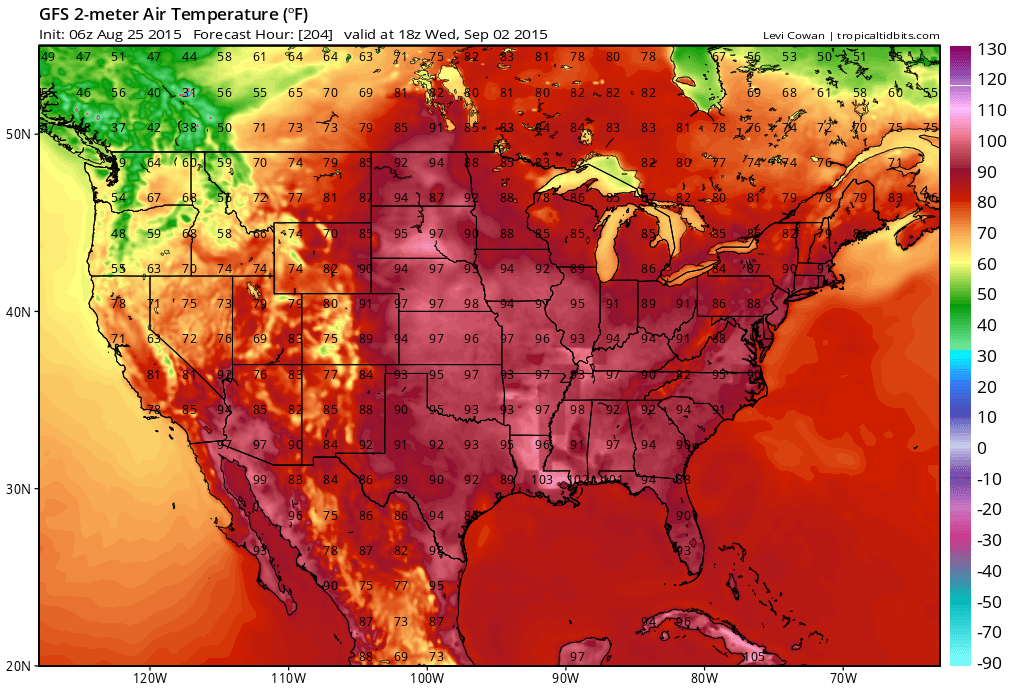
This is the Wednesday map for next week. More 90’s.
Here is the Thursday high temperature map (September 3rd). Appears the call for above normal temperatures might be right on schedule. Course, that doesn’t mean all of September will be hot! Never is. And, we have had a very difficult time shaking this pattern we have been in for the last couple of years. Semi-perma trough. Northwest flow keeps returning over and over again. This is because of the warm waters off the West Coast of the United States.
My September forecast has been for above normal temperatures and below normal precipitation.
We will need to monitor the tropics in September. If we were to have substantial widespread rainfall then it could be because of a land-falling tropical system in Texas or along the Gulf of Mexico.
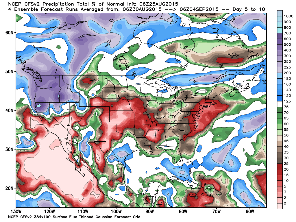
Let’s look at the first part of September and one models forecast for rainfall. This is the anomaly map. Lot of red and brown. That represents below normal rainfall.
This first map is for August 30th through September 4th.
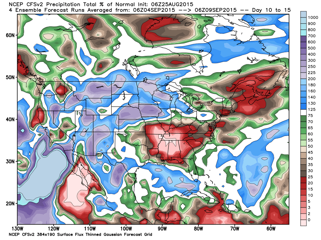
And this one is for September 4th through September 9th. Again, dry weather anticipated. We will see how my September forecast unfolds. August turned out spot on.
The Paducah, Kentucky National Weather Service will be holding a couple of spotter classes in September.
Here is the information – click here
Radars
WEATHER RADAR PAGE – Click here —
Don’t forget to support our sponsors!

How much precipitation should we expect over the next few days?
No precipitation is forecast through Friday.

Can we expect severe thunderstorms over the next 24 to 48 hours? Remember that a severe thunderstorm is defined as a thunderstorm that produces 58 mph winds or higher, quarter size hail or larger, and/or a tornado.
Thunderstorm threat level will be ZERO from Wednesday through Friday.
.
Wednesday: Severe weather is not anticipated.
Thursday: Severe weather is not anticipated.
Friday: Severe weather is not anticipated.
Saturday: Severe weather is not anticipated.
Sunday: Severe weather is not anticipated.
Monday: Severe weather is not anticipated.

No concerns.

I also set up a storm tracking page with additional links (use during active weather for quick reference)
Storm Tracking Tool Page

Here are the current river stage forecasts. You can click your state and then the dot for your location. It will bring up the full forecast and hydrograph.
Click Here For River Stage Forecasts…
Here are some current forecast hydrographs. These will be updated each day with new information.


Smithland Lock and Dam

Paducah, Kentucky Forecast Stage

Cairo, Illinois

Cape Girardeau, Missouri
Current Temperatures Around The Local Area


We have regional radars and local city radars – if a radar does not seem to be updating then try another one. Occasional browsers need their cache cleared. You may also try restarting your browser. That usually fixes the problem. Occasionally we do have a radar go down. That is why I have duplicates. Thus, if one fails then try another one.
If you have any problems then please send me an email beaudodson@usawx.com
WEATHER RADAR PAGE – Click here —
We also have a new national interactive radar – you can view that radar by clicking here.
Local interactive city radars include St Louis, Mt Vernon, Evansville, Poplar Bluff, Cape Girardeau, Marion, Paducah, Hopkinsville, Memphis, Nashville, Dyersburg, and all of eastern Kentucky – these are interactive radars. Local city radars – click here
NOTE: Occasionally you will see ground clutter on the radar (these are false echoes). Normally they show up close to the radar sites – including Paducah.

Regional Radar – Click on radar to take you our full radar page.


Regional Radar

Live Lightning Data – zoom and pan: Click here
Live Lightning Data with sound (click the sound button on the left side of the page): Click here
I also set up a storm tracking page with additional links (use during active weather for quick reference)
Storm Tracking Tool Page
![]()
Current WARNINGS (a warning means take action now). Click on your county to drill down to the latest warning information. Keep in mind that there can be a 2-3 minute delay in the updated warning information.
I strongly encourage you to use a NOAA Weather Radio or warning cell phone app for the most up to date warning information. Nothing is faster than a NOAA weather radio.


Color shaded counties are under some type of watch, warning, advisory, or special weather statement. Click your county to view the latest information.

Missouri Warnings

Illinois Warnings

Kentucky Warnings

Here is the official 6-10 day and 8-14 day temperature and precipitation outlook. Check the date stamp at the top of each image (so you understand the time frame).
The forecast maps below are issued by the Weather Prediction Center (NOAA).


The latest 8-14 day temperature and precipitation outlook. Note the dates are at the top of the image. These maps DO NOT tell you how high or low temperatures or precipitation will be. They simply give you the probability as to whether temperatures or precipitation will be above or below normal.


Who do you trust for your weather information and who holds them accountable?
I have studied weather in our region since the late 1970’s. I have 37 years of experience in observing our regions weather patterns. My degree is in Broadcast Meteorology from Mississippi State University and an Associate of Science (AS). I am currently working on my Bachelor’s Degree in Geoscience. Just need to finish two Spanish classes!
I am a member of the American Meteorological Society. I am a NOAA Weather-Ready Nation Ambassador. And, I am the Meteorologist for McCracken County Emergency Management.
I own and operate the Southern Illinois Weather Observatory.
There is a lot of noise on the internet. A lot of weather maps are posted without explanation. Over time you should learn who to trust for your weather information.
My forecast philosophy is simple and straight forward.
- Communicate in simple terms
- To be as accurate as possible within a reasonable time frame before an event
- Interact with you on Twitter, Facebook, and the blog
- Minimize the “hype” that you might see on television or through other weather sources
- Push you towards utilizing wall-to-wall LOCAL TV coverage during severe weather events
I am a recipient of the Mark Trail Award, WPSD Six Who Make A Difference Award, Kentucky Colonel, and the Caesar J. Fiamma” Award from the American Red Cross. In 2009 I was presented with the Kentucky Office of Highway Safety Award. I was recognized by the Kentucky House of Representatives for my service to the State of Kentucky leading up to several winter storms and severe weather outbreaks.
If you click on the image below you can read the Kentucky House of Representatives Resolution.

I am also President of the Shadow Angel Foundation which serves portions of western Kentucky and southern Illinois.
Many of my graphics are from www.weatherbell.com – a great resource for weather data, model data, and more


You can sign up for my AWARE email by clicking here I typically send out AWARE emails before severe weather, winter storms, or other active weather situations. I do not email watches or warnings. The emails are a basic “heads up” concerning incoming weather conditions.