For $5 a month you can receive the following. You may choose to receive these via your WeatherTalk app or regular text messaging.
- Severe weather app/text alerts from my keyboard to your app/cell phone. These are hand typed by Beau. During tornado outbreaks, you will receive numerous app/text messages telling you exactly where the tornado is located.
- Daily forecast app/texts from my computer to your app/cell phone.
- Social media links sent directly to your app/cell phone. When I update the blog, videos, or Facebook you will receive the link.
- AWARE emails. These emails keep you well ahead of the storm. They give you several days of lead time before significant weather events.
- Direct access to Beau via text and email. Your very own personal meteorologist. I work for you!
- Missouri and Ohio Valley centered video updates
- Long-range weather videos
- Week one, two, three and four temperature and precipitation outlooks.
- Monthly outlooks.
- Your subscription also will help support several local charities.
Would you like to subscribe? Subscribe at www.beaudodsonweather.com

I encourage subscribers to use the app vs regular text messaging. We have found text messaging to be delayed during severe weather. The app typically will receive the messages instantly. I recommend people have three to four methods of receiving their severe weather information.
Remember, my app and text alerts are hand typed and not computer generated. You are being given my personal attention during significant weather events.

WWW.WEATHERTALK.COM subscribers, here is my day to day schedule for your weather products.


We offer interactive local city live radars and regional radars. If a radar does not update then try another one. If a radar does not appear to be refreshing then hit Ctrl F5. You may also try restarting your browser.

August 2, 2018
Thursday Forecast Details
Forecast: Mostly sunny. Warmer. Patchy morning fog possible early. An evening thunderstorm possible near Randolph County to Jefferson County, Illinois. From there northward. Appears the broken band of thunderstorms will weaken after that point. They will move in from the north.
Temperatures: MO ~ 85 to 88 IL ~ 83 to 86 KY ~ 84 to 88 TN ~ 84 to 88
What is the chance of precipitation? MO ~ 20% (far north) IL ~ 30% (far northern counties) KY ~ 10% TN ~ 10%
Coverage of precipitation: Most likely none. A broken band of storms may briefly slide into our far northern counties. It will then weaken.
Wind: Variable to southwest at 3 to 6 mph
What impacts are anticipated from the weather? None to a few wet roadways and lightning.
My confidence in the forecast verifying: High
Is severe weather expected? No
The NWS defines severe weather as 58 mph wind or great, 1″ hail or larger, and/or tornadoes
Should I cancel my outdoor plans? No
UV Index: 9 to 10 High
Sunrise: 6:00 AM
We offer interactive local city live radars and regional radars. If a radar does not update then try another one.
Thursday Night Forecast Details:
Forecast: Mostly clear with a few passing clouds. An evening thunderstorm possible over our far northern counties.
Temperatures: MO ~ 63 to 66 IL ~ 63 to 66 KY ~ 64 to 66 TN ~ 64 to 66
What is the chance of precipitation? MO ~ 30% (far northern counties) IL ~ 40% (far northern counties) KY ~ 10% TN ~ 0%
Coverage of precipitation: None to isolated
Wind: South at 2 to 4 mph
What impacts are anticipated from the weather? None to isolated wet roadways and lightning
My confidence in the forecast verifying: High
Is severe weather expected? No
The NWS defines severe weather as 58 mph wind or great, 1″ hail or larger, and/or tornadoes
Should I cancel my outdoor plans? No
Sunset: 8:01 PM
Moonrise: 11:25 PM Waning Gibbous
Moonset: 11:20 AM
Forecast: Partly to mostly sunny. Warm and humid. An isolated shower or thunderstorm is possible. Most of the area will remain dry. A few locations will experiencing rain.
Temperatures: MO ~ 86 to 90 IL ~ 86 to 90 KY ~ 86 to 90 TN ~ 86 to 90
What is the chance of precipitation? MO ~ 20% IL ~ 20% KY ~ 20% TN ~ 10%
Coverage of precipitation: Isolated
Wind: South at 5 mph
What impacts are anticipated from the weather? Isolated wet roads and lightning.
My confidence in the forecast verifying: High
Is severe weather expected? Summer storms can produce pockets of high winds
The NWS defines severe weather as 58 mph wind or great, 1″ hail or larger, and/or tornadoes
Should I cancel my outdoor plans? No
UV Index: 9 to 10 High
Sunrise: 6:01 AM
We offer interactive local city live radars and regional radars. If a radar does not update then try another one
Friday Night Forecast Details:
Forecast: Mostly clear with a few passing clouds. Mild and humid. An isolated thunderstorm possible before 8 PM.
Temperatures: MO ~ 66 to 68 IL ~ 65 to 66 KY ~ 66 to 68 TN ~ 66 to 68
What is the chance of precipitation? MO ~ 10% IL ~ 10% KY ~ 10% TN ~ 10%
Coverage of precipitation: None to isolated
Wind: South at 2 to 4 mph
What impacts are anticipated from the weather? None to isolated wet roads and lightning.
My confidence in the forecast verifying: High
Is severe weather expected? Summer storms can produce pockets of high winds
The NWS defines severe weather as 58 mph wind or great, 1″ hail or larger, and/or tornadoes
Should I cancel my outdoor plans? No
Sunset: 8:00 PM
Moonrise: 11:57 PM Waning Gibbous
Moonset: 12:17 PM
August 4, 2018
Saturday Forecast Details
Forecast: Partly to mostly sunny. Warm and humid. An isolated thunderstorm possible. There will be warm air aloft and that should shut down most of the chances of precipitation.
Temperatures: MO ~ 88 to 92 IL ~ 88 to 92 KY ~ 88 to 92 TN ~ 88 to 92 Heat index values in the upper 90’s
What is the chance of precipitation? MO ~ 10% IL ~ 10% KY ~ 20% TN ~ 10%
Coverage of precipitation: None for most. An isolated storm possible.
Wind: South at 5 mph
What impacts are anticipated from the weather? None for most. An isolated wet road and lightning.
My confidence in the forecast verifying: Medium
Is severe weather expected? Summer storms can produce pockets of high winds
The NWS defines severe weather as 58 mph wind or great, 1″ hail or larger, and/or tornadoes
Should I cancel my outdoor plans? No
UV Index: 9 to 10 High
Sunrise: 6:02 AM
Saturday Night Forecast Details:
Forecast: Mostly clear with a few passing clouds.
Temperatures: MO ~ 65 to 70 IL ~ 65 to 68 KY ~ 65 to 70 TN ~ 65 to 70
What is the chance of precipitation? MO ~ 0% IL ~ 0% KY ~ 10% TN ~ 10%
Coverage of precipitation: None
Wind: South at 2 to 4 mph
What impacts are anticipated from the weather? Most likely none.
My confidence in the forecast verifying: Medium
Is severe weather expected? Summer storms can produce pockets of high winds
The NWS defines severe weather as 58 mph wind or great, 1″ hail or larger, and/or tornadoes
Should I cancel my outdoor plans? No
Sunset: 7:58 PM
Moonrise: 11:59 PM Last quarter
Moonset: 1:19 PM
August 5, 2018
Sunday Forecast Details
Forecast: Partly to mostly sunny. Warm. A few widely scattered thunderstorms possible. The best chance of thunderstorms will run from southeast Illinois into western Kentucky and Tennessee.
Temperatures: MO ~ 88 to 93 IL ~ 88 to 92 KY ~ 86 to 90 TN ~ 88 to 92 Heat index values of 98 to 104
What is the chance of precipitation? MO ~ 10% IL ~ 20% KY ~ 30% TN ~ 30%
Coverage of precipitation: Widely scattered
Wind: South at 5 to 10 mph
What impacts are anticipated from the weather? Wet roads. Lightning.
My confidence in the forecast verifying: Medium
Is severe weather expected? Summer storms can produce pockets of high winds
The NWS defines severe weather as 58 mph wind or great, 1″ hail or larger, and/or tornadoes
Should I cancel my outdoor plans? No, but check radars
UV Index: 9 to 10 High
Sunrise: 6:03 AM
Sunday Night Forecast Details:
Forecast: Partly cloudy. A few showers and thunderstorms.
Temperatures: MO ~ 70 to 74 IL ~ 70 to 74 KY ~ 70 to 74 TN ~ 70 to 74
What is the chance of precipitation? MO ~ 10% IL ~ 10% KY ~ 30% TN ~ 20%
Coverage of precipitation: Widely scattered
Wind: South at 2 to 4 mph with gusts to 8 mph
What impacts are anticipated from the weather? Wet roadways. Lightning.
My confidence in the forecast verifying: Medium
Is severe weather expected? Summer storms can produce pockets of high winds
The NWS defines severe weather as 58 mph wind or great, 1″ hail or larger, and/or tornadoes
Should I cancel my outdoor plans? No, but check radars
Sunset: 7:58 PM
Moonrise: 12:32 AM Waning crescent
Moonset: 2:24 PM
August 6, 2018
Monday Forecast Details
Forecast: A mix of sun and clouds. An isolated thunderstorm possible.
Temperatures: MO ~ 90 to 95 IL ~ 90 to 94 KY ~ 90 to 94 TN ~ 90 to 94 Heat index values of 98 to 104
What is the chance of precipitation? MO ~ 20% IL ~ 20% KY ~ 20% TN ~ 20%
Coverage of precipitation: Isolated
Wind: South at 5 to 10 mph with gusts to 14
What impacts are anticipated from the weather? Isolated wet roads. Lightning.
My confidence in the forecast verifying: Medium
Is severe weather expected? Summer storms can produce pockets of high winds
The NWS defines severe weather as 58 mph wind or great, 1″ hail or larger, and/or tornadoes
Should I cancel my outdoor plans? No, but check radars
UV Index: 9 to 10 High
Sunrise: 6:04 AM
Monday Night Forecast Details:
Forecast: Partly cloudy. Widely scattered showers and thunderstorms.
Temperatures: MO ~ 70 to 74 IL ~ 70 to 74 KY ~ 70 to 74 TN ~ 70 to 74
What is the chance of precipitation? MO ~ 30% IL ~ 30% KY ~ 30% TN ~ 30%
Coverage of precipitation: Widely scattered
Wind: South at 6 to 12 mph
What impacts are anticipated from the weather? Wet roadways. Lightning.
My confidence in the forecast verifying: Medium
Is severe weather expected? Summer storms can produce pockets of high winds
The NWS defines severe weather as 58 mph wind or great, 1″ hail or larger, and/or tornadoes
Should I cancel my outdoor plans? No, but check radars
Sunset: 7:57 PM
Moonrise: 1:12 AM Waning crescent
Moonset: 3:29 PM
August 7, 2018
Tuesday Forecast Details
Forecast: Mostly cloudy. Scattered showers and thunderstorms.
Temperatures: MO ~ 84 to 88 IL ~ 84 to 88 KY ~ 84 to 88 TN ~ 84 to 88
What is the chance of precipitation? MO ~ 50%-60% IL ~ 50%-60% KY ~ 50%-60% TN ~ 50%-60%
Coverage of precipitation: Scattered to numerous
Wind: South at 5 to 10 mph with gusts to 15 mph
What impacts are anticipated from the weather? Wet roads. Lightning.
My confidence in the forecast verifying: Medium
Is severe weather expected? A few strong storms are possible. Monday updates.
The NWS defines severe weather as 58 mph wind or great, 1″ hail or larger, and/or tornadoes
Should I cancel my outdoor plans? Check radars. Showers and storms likely
UV Index: 5 to 7 Medium
Sunrise: 6:04 AM
Tuesday Night Forecast Details:
Forecast: Cloudy with showers and thunderstorms possible.
Temperatures: MO ~ 70 to 74 IL ~ 70 to 74 KY ~ 70 to 74 TN ~ 70 to 74
What is the chance of precipitation? MO ~ 40% to 50% IL ~ 40% to 50% KY ~ 40% to 50% TN ~ 50% to 60%
Coverage of precipitation: Perhaps numerous
Wind: Southwest at 6 to 12 mph
What impacts are anticipated from the weather? Wet roadways. Lightning.
My confidence in the forecast verifying: Medium
Is severe weather expected? A few strong storms are possible.
The NWS defines severe weather as 58 mph wind or great, 1″ hail or larger, and/or tornadoes
Should I cancel my outdoor plans? Check radars
Sunset: 7:56 PM
Moonrise: 1:58 AM Waning crescent
Moonset: 4:36 PM
August 8, 2018
Wednesday Forecast Details
Forecast: Mostly cloudy. Scattered showers and thunderstorms.
Temperatures: MO ~ 84 to 88 IL ~ 84 to 88 KY ~ 84 to 88 TN ~ 84 to 88
What is the chance of precipitation? MO ~ 50%-60% IL ~ 50%-60% KY ~ 50%-60% TN ~ 50%-60%
Coverage of precipitation: Scattered to numerous
Wind: South at 5 to 10 mph with gusts to 15 mph
What impacts are anticipated from the weather? Wet roads. Lightning.
My confidence in the forecast verifying: Medium
Is severe weather expected? Unlikely, but monitor updates. If the front remains in the region then a few strong storms will be possible.
The NWS defines severe weather as 58 mph wind or great, 1″ hail or larger, and/or tornadoes
Should I cancel my outdoor plans? Check radars. Showers and storms likely
UV Index: 6 to 8 Medium
Sunrise: 6:05 AM
Wednesday Night Forecast Details:
Forecast: Partly cloudy. A few remaining showers and thunderstorms possible.
Temperatures: MO ~ 64 to 68 IL ~ 64 to 68 KY ~ 64 to 68 TN ~ 64 to 68
What is the chance of precipitation? MO ~ 20% to 30% IL ~ 20% to 30% KY ~ 20% to 30% TN ~ 20% to 30%
Coverage of precipitation: Widely scattered
Wind: Southwest to west at 6 to 12 mph
What impacts are anticipated from the weather? Wet roadways. Lightning.
My confidence in the forecast verifying: Medium
Is severe weather expected? Unlikely
The NWS defines severe weather as 58 mph wind or great, 1″ hail or larger, and/or tornadoes
Should I cancel my outdoor plans? No, but check radars
Sunset: 7:54 PM
Moonrise: 2:52 AM Waning crescent
Moonset: 7:54 PM
Learn more about the UV index readings. Click here.

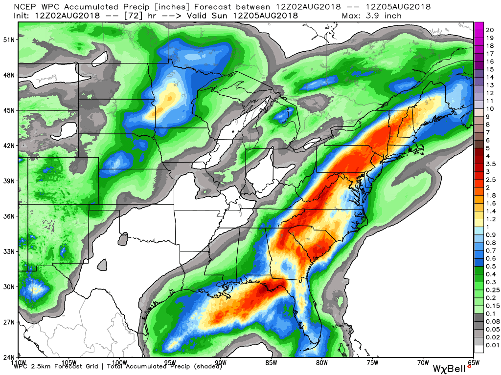
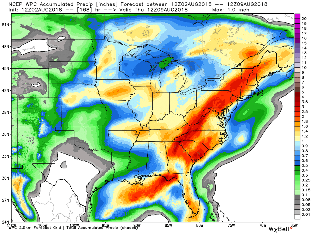
Here is the latest WPC / NOAA Rainfall charts
This graphic will not cover those wild swings in rainfall totals that occur from locally heavy thunderstorms. These number will be greatly underdone where slow moving thunderstorms occur.
This graphic is from today into Sunday morning
This graphic is the seven day rainfall outlook. This takes us through Thursday morning.
Most of this would fall Monday night into Wednesday night. A cold front nears the area.

.

We offer interactive local city live radars and regional radars. If a radar does not update then try another one.
If a radar does not appear to be refreshing then hit Ctrl F5 on your keyboard.
You may also try restarting your browser.
The local city view radars also have clickable warnings.
During the winter months, you can track snow and ice by clicking the winterize button on the local city view interactive radars.

Questions? Broken links? Other questions?
You may email me at beaudodson@usawx.com

The National Weather Service defines a severe thunderstorm as one that produces quarter size hail or larger, 58 mph winds or greater, and/or a tornado.
ind with height and/or the increase of wind speed with height. This is one ingredient when forecasting severe thunderstorms.
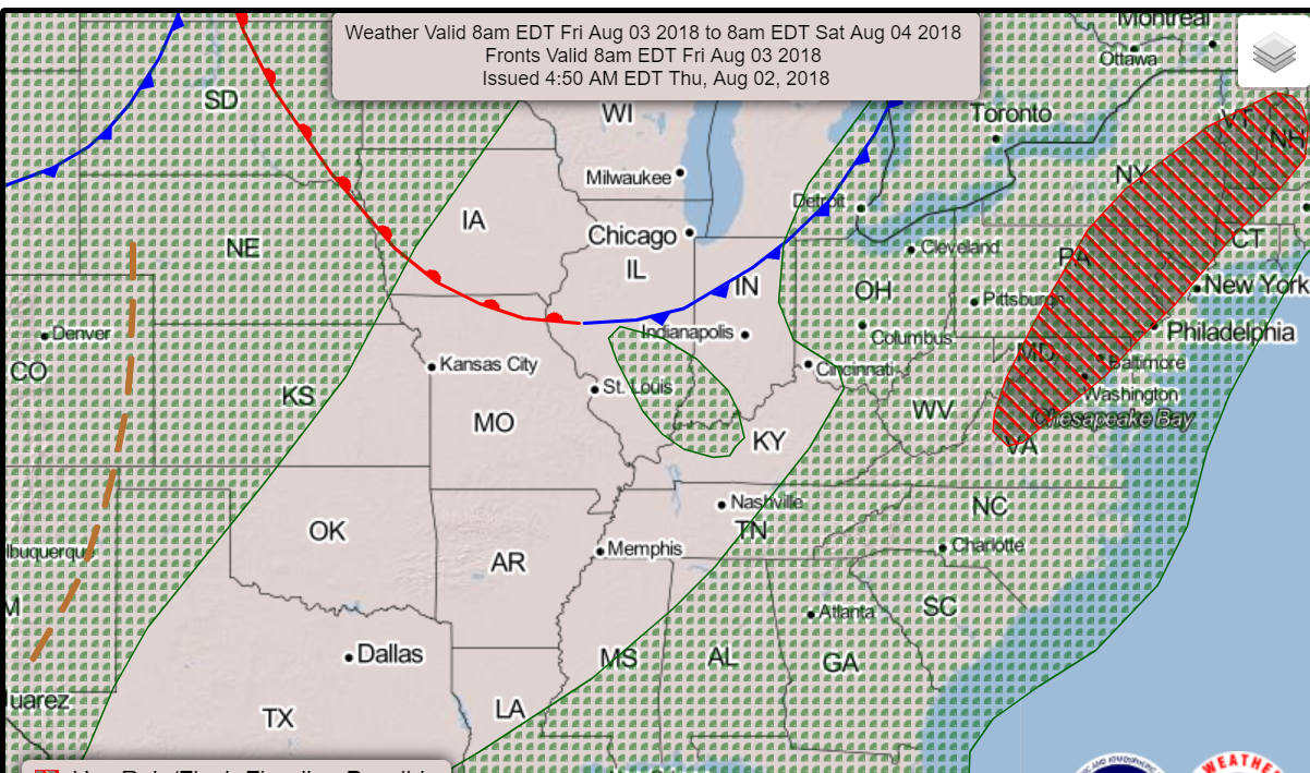
Today through Wednesday: There is a slight chance of a thunderstorm today across southeast Illinois and the Pennyrile area of western Kentucky.
There is also a chance of a band of thunderstorms approaching our northern counties late this afternoon into the first half of tonight (see graphics below). This line of storms may clip our far northern counties. It should weaken as it moves south and southeast.
An isolated storm is possible Friday afternoon and evening across southeast Illinois and mostly the Pennyrile area of western Kentucky. Chances there will be low (20% or less)
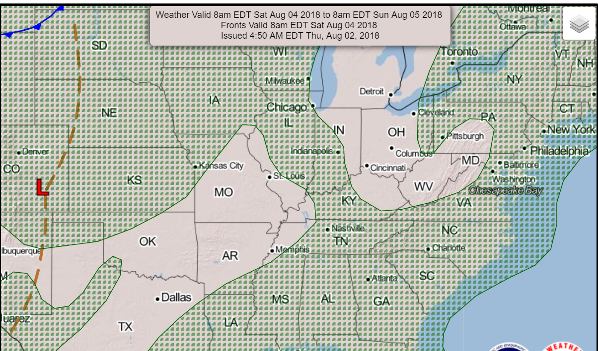
Thunderstorms are unlikely Saturday and Saturday night.
A few widely scattered thunderstorms are possible across southeast Illinois and western Kentucky.
Thunderstorm activity may increase Monday afternoon into Wednesday. This will occur as a weak cold front pushes into our region from the north. Some of these thunderstorms could be locally strong. It is a bit early to know if storms will be severe.
Summer thunderstorms can produce isolated microbursts.
microburst winds can exceed 50 mph.
What are microbursts?

Interactive live weather radar page. Choose the city nearest your location. If one of the cities does not work then try a nearby one. Click here.
National map of weather watches and warnings. Click here.
Storm Prediction Center. Click here.
Weather Prediction Center. Click here.

Live lightning data: Click here.

Interactive GOES R satellite. Track clouds. Click here.

Here are the latest local river stage forecast numbers Click Here.
Here are the latest lake stage forecast numbers for Kentucky Lake and Lake Barkley Click Here.

The summer outlook have been posted for subscribers. Scroll down to see the outlook.Not a subscriber? Learn more at this link.

Weather Headlines
- Calm weather today into Sunday
- A couple of storms across eastern Missouri towards St Louis this evening (prob staying north of us)
- Warm and a it more humid.
- Only isolated thunderstorm chances over the coming days (majority of region will remain dry through Monday morning)
- A cold front early next week
The weatherman will have a bit of a break over the next few days. It will be a bit warmer with each passing day. A bit more humid, as well.
You can expect highs today through Sunday to mostly be in the upper 80’s to lower 90’s (the 90’s may hold off until SAT or SUN).
Dew points will slowly rise, as well. Dew points control how humid it feels.
There will be a small chance of isolated thunderstorms over mostly southeast Illinois and western Kentucky. If you need rain then don’t anticipate rain. The chances of you receiving a shower will be 20% or less.
I am watching a weak disturbance moving into our region from the north and northwest this evening. This front may have a band of spotty showers and thunderstorms.
At this time, it appears the rain chances will remain just a tad north of our area. I will watch the Randolph County to Jefferson County line (there and northward).
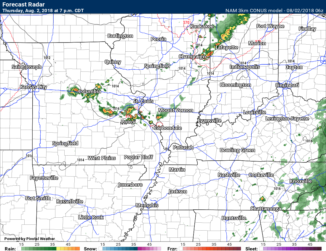
Here is the NAM model showing those thunderstorms.
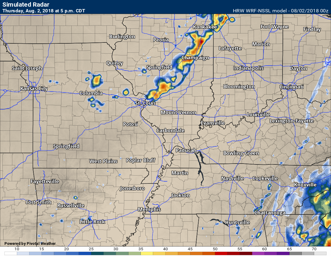
This is the WRF model. It also shows those storms. This is 5 PM this evening.
This is one of the high resolution models from the SPC. HREF NAM (again for this evening)

Early next week
The next weather maker for our region won’t arrive until Monday night and Tuesday. This is when a cold front will settle into our region.
This front will bump into warm and moist air. That means locally heavy rain.
The front will likely stall over our region. A stalled front in August typically means someone will be on the receiving end of torrential downpours. Plenty of moisture to work with during the summer months.
I am not quite sure if severe weather will be an issue. Wind fields won’t be overly impressive. I believe the main concern will be lightning, locally heavy rain, and gusty wind. If thunderstorms train over the same areas then flash flooding will be a occur.
This is the NOAA weather map for Friday. You can see small thunderstorm chances over a portion of our region.
and here is the Saturday weather map. Again, mostly dry in our region. Small storm chances over our eastern counties.
Here are the PWAT values for Monday night into Wednesday.
PWAT is a measure of moisture in the atmosphere. Charts are showing 1.7+ numbers. That is a lot of moisture to work with.
WeatherBrains Episode 652
Tonight’s Guest WeatherBrain is a weather legend, having spanned four decades as a broadcast meteorologist. He is a Fellow of the AMS. Joe Witte, welcome to WeatherBrains!
Other discussions in this weekly podcast include topics like:
- Athletes who are passionate about weather
- What all is involved with TV weather internships
- NASA’s intern program
- KATV’s Ned Perme retiring after 34 years
- Astronomy Outlook with Tony Rice
- Drake University sportscaster Larry Cotlar dies in Iowa flash flooding
- and more!
Link to web-site https://weatherbrains.com/
Previous episodes can be viewed by clicking here.
We offer interactive local city live radars and regional radars. If a radar does not update then try another one. If a radar does not appear to be refreshing then hit Ctrl F5. You may also try restarting your browser.
The local city view radars also have clickable warnings.
During the winter months, you can track snow and ice by clicking the winterize button on the local city view interactive radars.
You may email me at beaudodson@usawx.com
Find me on Facebook!

Find me on Twitter!

Did you know that a portion of your monthly subscription helps support local charity projects?
You can learn more about those projects by visiting the Shadow Angel Foundation website and the Beau Dodson News website.

I encourage subscribers to use the app vs regular text messaging. We have found text messaging to be delayed during severe weather. The app typically will receive the messages instantly. I recommend people have three to four methods of receiving their severe weather information.
Remember, my app and text alerts are hand typed and not computer generated. You are being given personal attention during significant weather events.
