Click schedule for a larger view. Keep in mind, during active weather this schedule will change. There will be additional updates outside of what has been posted here.


We offer interactive local city view radars and regional radars.
If a radar does not update then try another one. If a radar does not appear to be refreshing then hit Ctrl F5. You may also try restarting your browser.

Interactive Radars:
Interactive live weather radar page. Choose the city nearest your location. If one of the city radars won’t load then try a nearby one. Click here.
August 19, 2018
Sunday Forecast Details
Forecast: Patchy morning fog. Partly to mostly sunny. A few clouds. Rain chances at 10% or less (stray thunderstorm if anything at all)
Temperatures: MO ~ 84 to 88 IL ~ 84 to 88 KY ~ 84 to 88 TN ~ 85 to 88
What is the chance of precipitation? MO ~ 10% IL ~ 10% KY ~ 10% to 20% TN ~ 10% to 20%
Coverage of precipitation: None to isolated
Wind: Southeast at 5 to 10 mph
What impacts are anticipated from the weather? None to perhaps isolated wet roads and lightning.
My confidence in the forecast verifying: High
Is severe weather expected? Summer storms can produce isolated high winds
The NWS defines severe weather as 58 mph wind or great, 1″ hail or larger, and/or tornadoes
Should I cancel my outdoor plans? No
UV Index: 8 to 10 High
Sunrise: 6:15 AM
We offer interactive local city view radars and regional radars.
Sunday Night Forecast Details:
Forecast: Becoming cloudy. A few showers and thunderstorms possible late at night. Some question on exact timing. After midnight would be more likely than before. The rain may hold off until morning.
Temperatures: MO ~ 68 to 72 IL ~ 68 to 72 KY ~ 68 to 72 TN ~ 68 to 72
What is the chance of precipitation? MO ~ 60% to 70% (mainly late) IL ~ 50% to 60% (mainly late) KY ~ 50% (mainly late) TN ~ 50% (mainly late)
Coverage of precipitation: Most likely none early. Increasing chances late tonight (esp over southeast Missouri and southern Illinois)
Wind: Southeast at 5 to 10 mph
What impacts are anticipated from the weather? Wet roadways and lightning. Gusty winds near storms.
My confidence in the forecast verifying: High
Is severe weather expected? Summer storms can occasionally produce isolated high winds
The NWS defines severe weather as 58 mph wind or great, 1″ hail or larger, and/or tornadoes
Should I cancel my outdoor plans? No
Sunset: 7:52 PM
Moonrise: 2:53 PM First Quarter
Moonset: 12:33 AM
August 20, 2018
Monday Forecast Details
Forecast: A period or two of showers and thunderstorms. Some storms could be intense. There should be lulls between whatever precipitation happens in the morning and new activity forming in the afternoon/evening.
Temperatures: MO ~ 82 to 85 IL ~ 80 to 85 KY ~ 82 to 85 TN ~ 82 to 86
What is the chance of precipitation? MO ~ 60% IL ~ 60% KY ~ 60% TN ~ 60%
Coverage of precipitation: Scattered to perhaps numerous, at times
Wind: South and southwest at 8 to 16 mph and gusty
What impacts are anticipated from the weather? Wet roadways and lightning. A few intense storms possible. Locally heavy rain where storms occur.
My confidence in the forecast verifying: High
Is severe weather expected? Severe thunderstorms are possible.
The NWS defines severe weather as 58 mph wind or great, 1″ hail or larger, and/or tornadoes
Should I cancel my outdoor plans? Have a plan B and monitor updates
UV Index: 6 to 8 Medium/high (depends on clouds)
Sunrise: 6:15 AM
Monday Night Forecast Details:
Forecast: Mostly cloudy with a period of showers and thunderstorms along an incoming cold front. Locally heavy rain and locally strong storms. Showers and thunderstorms tapering off as we move through the night.
Temperatures: MO ~ 64 to 68 IL ~ 64 to 68 KY ~ 64 to 68 TN ~ 66 to 70
What is the chance of precipitation? MO ~ 60% IL ~60% KY ~60% TN ~ 60%
Coverage of precipitation: A period of numerous showers and thunderstorms
Wind: West and southwest at 7 to 14 mph with gusts to 20 mph
What impacts are anticipated from the weather? Wet roadways and lightning. A few intense storms possible. Locally heavy rain where storms occur.
My confidence in the forecast verifying: Medium
Is severe weather expected? A few storms could be strong early in the night with gusty winds.
The NWS defines severe weather as 58 mph wind or great, 1″ hail or larger, and/or tornadoes
Should I cancel my outdoor plans? Have a plan B and monitor updates
Sunset: 7:40 PM
Moonrise: 3:48 PM Waxing Gibbous
Moonset: 1:12 AM
August 21, 2018
Tuesday Forecast Details
Forecast: Partly sunny. A chance of isolated showers and thunderstorms. Tuesday may end up dry.
Temperatures: MO ~ 80 to 85 IL ~ 78 to 84 KY ~ 80 to 85 TN ~ 80 to 85
What is the chance of precipitation? MO ~ 10% to 20% IL ~ 10% to 20% KY ~ 10% to 20% TN ~ 10% to 20%
Coverage of precipitation: Isolated
Wind: Northwest at 10 to 20 mph with higher gusts (esp over southern Illinois and western Kentucky)
What impacts are anticipated from the weather? A few wet roads and lightning.
My confidence in the forecast verifying: High
Is severe weather expected? No
The NWS defines severe weather as 58 mph wind or great, 1″ hail or larger, and/or tornadoes
Should I cancel my outdoor plans? No
UV Index: 8 to 10 High
Sunrise: 6:16 AM
Tuesday Night Forecast Details:
Forecast: Mostly clear with a few clouds. Patchy dense fog possible.
Temperatures: MO ~ 58 to 64 IL ~ 58 to 64 KY ~ 60 to 64 TN ~ 60 to 64
What is the chance of precipitation? MO ~ 0% IL ~ 0% KY ~ 0% TN ~ 0%
Coverage of precipitation: None
Wind: North and northwest at 4 to 8 mph with gusts to 16 mph early in the night
What impacts are anticipated from the weather? Lower visibility in areas with fog.
My confidence in the forecast verifying: High
Is severe weather expected? No
The NWS defines severe weather as 58 mph wind or great, 1″ hail or larger, and/or tornadoes
Should I cancel my outdoor plans? No
Sunset: 7:38 PM
Moonrise: 4:39 PM Waxing Gibbous
Moonset: 1:56 AM
August 22, 2018
Wednesday Forecast Details
Forecast: Patchy morning fog. Some morning clouds. Cooler and less humid.
Temperatures: MO ~ 80 to 84 IL ~ 78 to 84 KY ~ 80 to 84 TN ~ 80 to 85
What is the chance of precipitation? MO ~ 0% IL ~ 0% KY ~ 0% TN ~ 0%
Coverage of precipitation: None
Wind: North and northwest at 5 to 10 mph
What impacts are anticipated from the weather? Lower visibility in areas with fog
My confidence in the forecast verifying: High
Is severe weather expected? No
The NWS defines severe weather as 58 mph wind or great, 1″ hail or larger, and/or tornadoes
Should I cancel my outdoor plans? No
UV Index: 8 to 10 High
Sunrise: 6:17 AM
Wednesday Night Forecast Details:
Forecast: Mostly clear. Pleasant. Patchy fog.
Temperatures:MO ~ 58 to 62 IL ~ 56 to 62 KY ~ 58 to 64 TN ~ 60 to 62
What is the chance of precipitation? MO ~ 0% IL ~ 0% KY ~ 0% TN ~ 0%
Coverage of precipitation: Most likely none.
Wind: North at 4 to 8 mph
What impacts are anticipated from the weather? Lower visibility if fog develops.
My confidence in the forecast verifying: High
Is severe weather expected? No
The NWS defines severe weather as 58 mph wind or great, 1″ hail or larger, and/or tornadoes
Should I cancel my outdoor plans? No
Sunset: 7:37 PM
Moonrise: 5:26 PM Waxing Gibbous
Moonset: 2:43 AM
August 23, 2018
Thursday Forecast Details
Forecast: Mostly sunny. Nice.
Temperatures: MO ~ 80 to 85 IL ~ 80 to 85 KY ~ 80 to 85 TN ~ 80 to 85
What is the chance of precipitation? MO ~ 0% IL ~ 0% KY ~ 0% TN ~ 0%
Coverage of precipitation: Most likely none
Wind: Northeast and east at 5 to 10 mph
What impacts are anticipated from the weather? Most likely none
My confidence in the forecast verifying: High
Is severe weather expected? No
The NWS defines severe weather as 58 mph wind or great, 1″ hail or larger, and/or tornadoes
Should I cancel my outdoor plans? No
UV Index: 8 to 10 High
Sunrise: 6:18 AM
Thursday Night Forecast Details:
Forecast: Mostly clear. Pleasant. Patchy fog.
Temperatures:MO ~ 58 to 64 IL ~ 58 to 64 KY ~ 58 to 64 TN ~ 58 to 64
What is the chance of precipitation? MO ~ 0% IL ~ 0% KY ~ 0% TN ~ 0%
Coverage of precipitation: Most likely none.
Wind: Southeast at 5 to 10 mph
What impacts are anticipated from the weather? Lower visibility if fog develops.
My confidence in the forecast verifying: High
Is severe weather expected? No
The NWS defines severe weather as 58 mph wind or great, 1″ hail or larger, and/or tornadoes
Should I cancel my outdoor plans? No
Sunset: 7:36 PM
Moonrise: 6:09 PM Waxing Gibbous
Moonset: 3:34 AM
August 24, 2018
Friday Forecast Details
Forecast: Partly to mostly sunny. Mild.
Temperatures: MO ~ 78 to 84 IL ~ 78 to 84 KY ~ 80 to 84 TN ~ 80 to 84
What is the chance of precipitation? MO ~ 10% IL ~ 0% KY ~ 0% TN ~ 0%
Coverage of precipitation: Most likely none
Wind: South and southeast at 5 to 10 mph
What impacts are anticipated from the weather? Most likely none
My confidence in the forecast verifying: Medium
Is severe weather expected? No
The NWS defines severe weather as 58 mph wind or great, 1″ hail or larger, and/or tornadoes
Should I cancel my outdoor plans? No
UV Index: 8 to 10 High
Sunrise: 6:19 AM
Friday Night Forecast Details:
Forecast: Partly cloudy. A slight chance of a shower or thunderstorm.
Temperatures: MO ~ 63 to 67 IL ~ 63 to 66 KY ~ 64 to 66 TN ~ 64 to 68
What is the chance of precipitation? MO ~ 20% IL ~ 20% KY ~ 20% TN ~ 20%
Coverage of precipitation: None to isolated
Wind: South at 5 to 10 mph
What impacts are anticipated from the weather? None to isolated wet roadways and lightning
My confidence in the forecast verifying: LOW
Is severe weather expected? No
The NWS defines severe weather as 58 mph wind or great, 1″ hail or larger, and/or tornadoes
Should I cancel my outdoor plans? No
Sunset: 7:34 PM
Moonrise: 6:48 PM Waxing Gibbous
Moonset: 4:27 AM
August 25, 2018
Saturday Forecast Details
Forecast: Partly cloudy with a chance of a shower or thunderstorm. Warmer and a bit more humid.
Temperatures: MO ~ 84 to 88 IL ~ 84 to 88 KY ~ 84 to 88 TN ~ 84 to 88
What is the chance of precipitation? MO ~ 30% IL ~ 30% KY ~ 30% TN ~ 30%
Coverage of precipitation: Scattered
Wind: South and southwest at 5 to 10 mph
What impacts are anticipated from the weather? Scattered wet roadways and lightning.
My confidence in the forecast verifying: LOW
Is severe weather expected? Unlikely
The NWS defines severe weather as 58 mph wind or great, 1″ hail or larger, and/or tornadoes
Should I cancel my outdoor plans? No, but monitor updates and radars.
UV Index: 8 to 10 High
Sunrise: 6:20AM
Saturday Night Forecast Details:
Forecast: Partly cloudy. A chance of a shower or thunderstorm.
Temperatures: MO ~ 63 to 67 IL ~ 63 to 66 KY ~ 64 to 66 TN ~ 64 to 68
What is the chance of precipitation? MO ~ 30% IL ~ 30% KY ~ 30% TN ~ 30%
Coverage of precipitation: Scattered
Wind: Southwest at 5 to 10 mph
What impacts are anticipated from the weather? Scattered wet roadways and lightning
My confidence in the forecast verifying: LOW
Is severe weather expected? Unlikely
The NWS defines severe weather as 58 mph wind or great, 1″ hail or larger, and/or tornadoes
Should I cancel my outdoor plans? No, but monitor updated forecasts and radars
Sunset: 7:33 PM
Moonrise: 7:23 PM Waxing Gibbous
Moonset: 5:22 AM
August 26, 2018
Sunday Forecast Details
Forecast: Mostly sunny. Warm.
Temperatures: MO ~ 84 to 88 IL ~ 84 to 88 KY ~ 84 to 88 TN ~ 84 to 88
What is the chance of precipitation? MO ~ 10% IL ~ 10% KY ~ 10% TN ~ 10%
Coverage of precipitation: Most likely none, but monitor updates
Wind: West at 5 to 10 mph
What impacts are anticipated from the weather? Most likely none, but monitor updates.
My confidence in the forecast verifying: LOW
Is severe weather expected? No
The NWS defines severe weather as 58 mph wind or great, 1″ hail or larger, and/or tornadoes
Should I cancel my outdoor plans? No
UV Index: 8 to 10 High
Sunrise: 6:20AM
Sunday Night Forecast Details:
Forecast: Mostly clear.
Temperatures: MO ~ 63 to 66 IL ~ 63 to 66 KY ~ 64 to 66 TN ~ 64 to 68
What is the chance of precipitation? MO ~ 10% IL ~ 10% KY ~ 10% TN ~ 10%
Coverage of precipitation: Most likely none
Wind: West at 5 to 10 mph
What impacts are anticipated from the weather? Most likely none, but monitor updates.
My confidence in the forecast verifying: LOW
Is severe weather expected? Unlikely
The NWS defines severe weather as 58 mph wind or great, 1″ hail or larger, and/or tornadoes
Should I cancel my outdoor plans? No
Sunset: 7:31 PM
Moonrise: 7:57 PM Full
Moonset: 6:19 AM

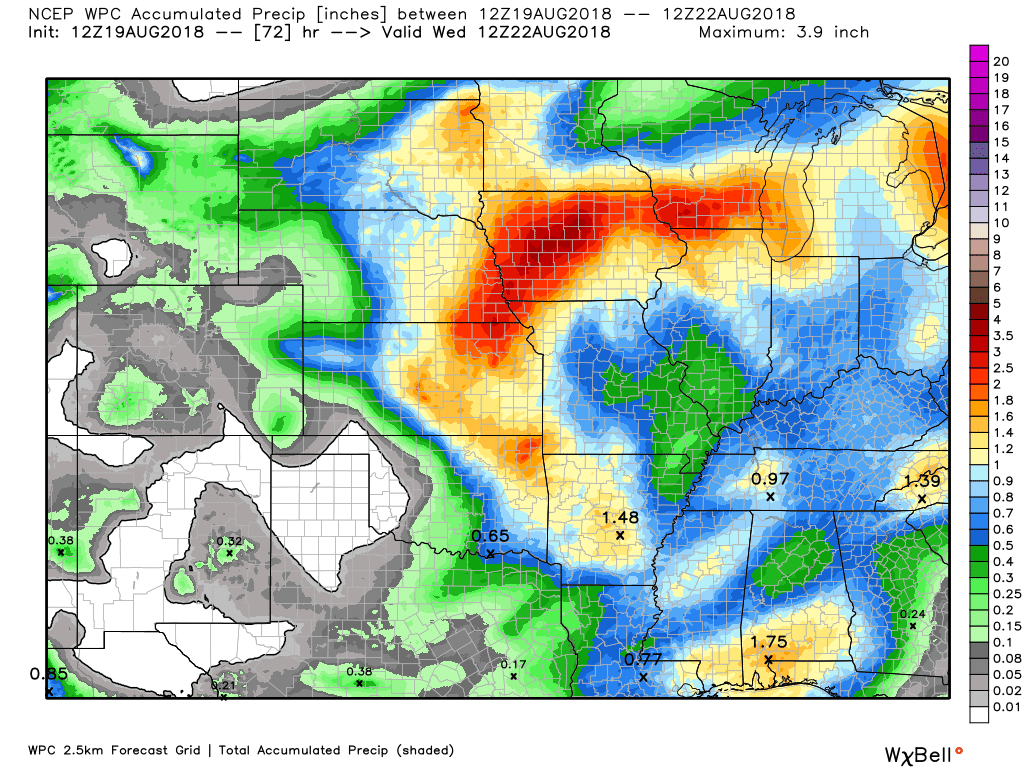
Here is the latest WPC/NOAA rainfall outlook.
Keep in mind, this graphic won’t capture those locally heavy thunderstorms that we often have during the summer months. Those storms can easily drop an inch or more of rain in less than an hour.
Here is the 72-hour rainfall forecast through 7 AM Wednesday
Here is the seven-day rainfall forecast through 7 AM Sunday
A fairly large rain event over the coming days. Some areas will likely top three inches of rain. This is much needed rain for many areas.
This is one of the larger/widespread rain events over the last few months.

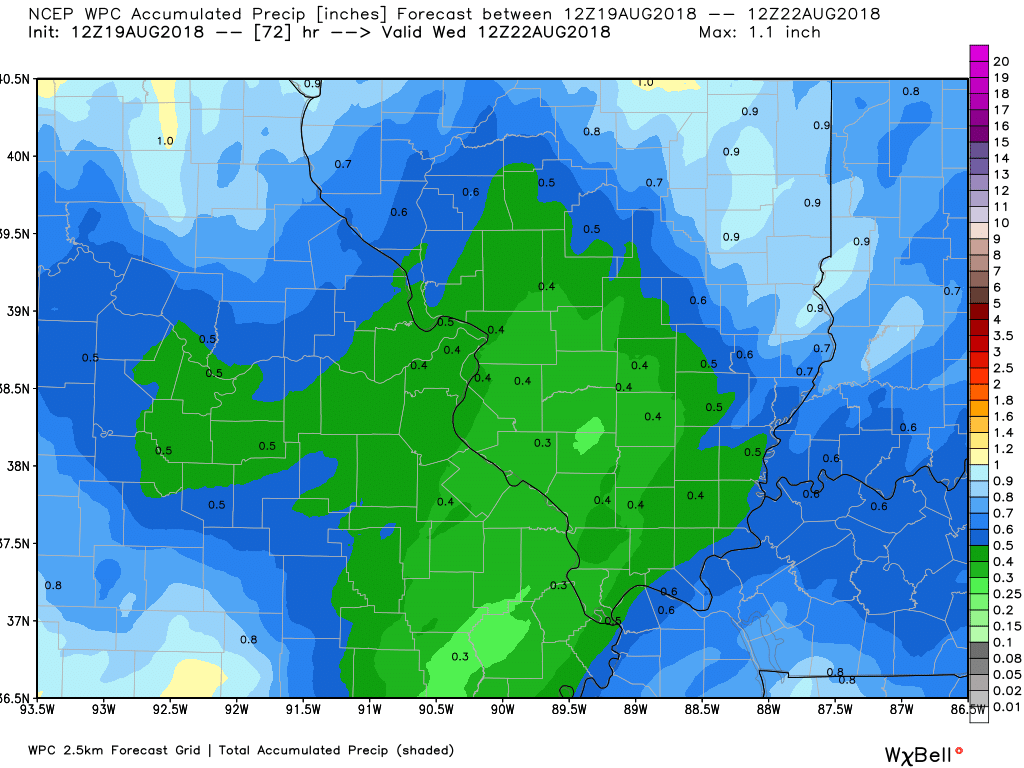
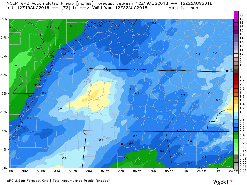
Let’s zoom in a bit.
This is southeast Missouri and southern Illinois
Kentucky and Tennessee centered

We offer interactive local city live radars and regional radars.
If a radar does not update then try another one. If a radar does not appear to be refreshing then hit Ctrl F5 on your keyboard.
You may also try restarting your browser. The local city view radars also have clickable warnings.
During the winter months, you can track snow and ice by clicking the winterize button on the local city view interactive radars.

Questions? Broken links? Other questions?
You may email me at beaudodson@usawx.com

The National Weather Service defines a severe thunderstorm as one that produces quarter size hail or larger, 58 mph winds or greater, and/or a tornado.
Sunday through Monday night: Isolated thunderstorms area possible Sunday afternoon. Most areas will remain dry.
Thunderstorm chances begin to increase west to east as we move through tonight, but especially Monday.
Some of the storms Monday afternoon and evening could produce damaging winds. There is a low end risk of severe weather. Monitor updates.
Lightning will be a concern for outdoor activities.
Locally heavy rain is a concern over the coming days. Avoid flooded roadways.
Tuesday through Friday: Severe weather is not anticipated.
Summer thunderstorms can produce isolated microbursts.
microburst winds can exceed 50 mph.
What are microbursts?

Interactive live weather radar page. Choose the city nearest your location. If one of the cities does not work then try a nearby one. Click here.
National map of weather watches and warnings. Click here.
Storm Prediction Center. Click here.
Weather Prediction Center. Click here.

Live lightning data: Click here.

Interactive GOES R satellite. Track clouds. Click here.

Here are the latest local river stage forecast numbers Click Here.
Here are the latest lake stage forecast numbers for Kentucky Lake and Lake Barkley Click Here.

- Thunderstorm chances increase tonight into Monday.
- Mostly calm weather Tuesday through Friday.
- Cooler and less humid this week (after Monday).
- Monitoring late Friday night into Sunday for some shower or thunderstorm chances (low confidence on that part of the forecast)
Just a quick Sunday update for subscribers and non-subscribers.
We have a storm system that will push into the region tonight and Monday. This will bring another chance of locally heavy rain.
Shower and thunderstorm chances before midnight will be low. Chances increase during the AM hours of Monday into Monday evening/night. Some of the storms could be strong.
CAPE (a measure on instability) should be high enough to support locally strong to severe thunderstorms Monday afternoon and night. The main concern will be damaging wind. Small hail can’t be ruled out. Frequent lightning, as well.
I would not be surprised if we have a few severe thunderstorm warnings as the main front pushes across the region (Monday afternoon and night).
Rain chances will taper as we move into Monday night/Tuesday morning.
Perhaps a few remaining showers and thunderstorms Tuesday (it may end up dry).
Dry weather is expected Wednesday through Friday.
Temperatures Tuessday into Friday will be cooler. Humidity will be lower. We may even experience some upper 50’s at night.
I am monitoring another system Friday night into Saturday night. Confidence on that system is low. Models are not in agreement on the timing or strength of the system. I will monitor trends and update the forecast as necessary.
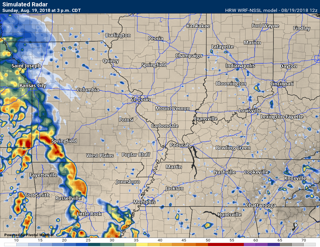
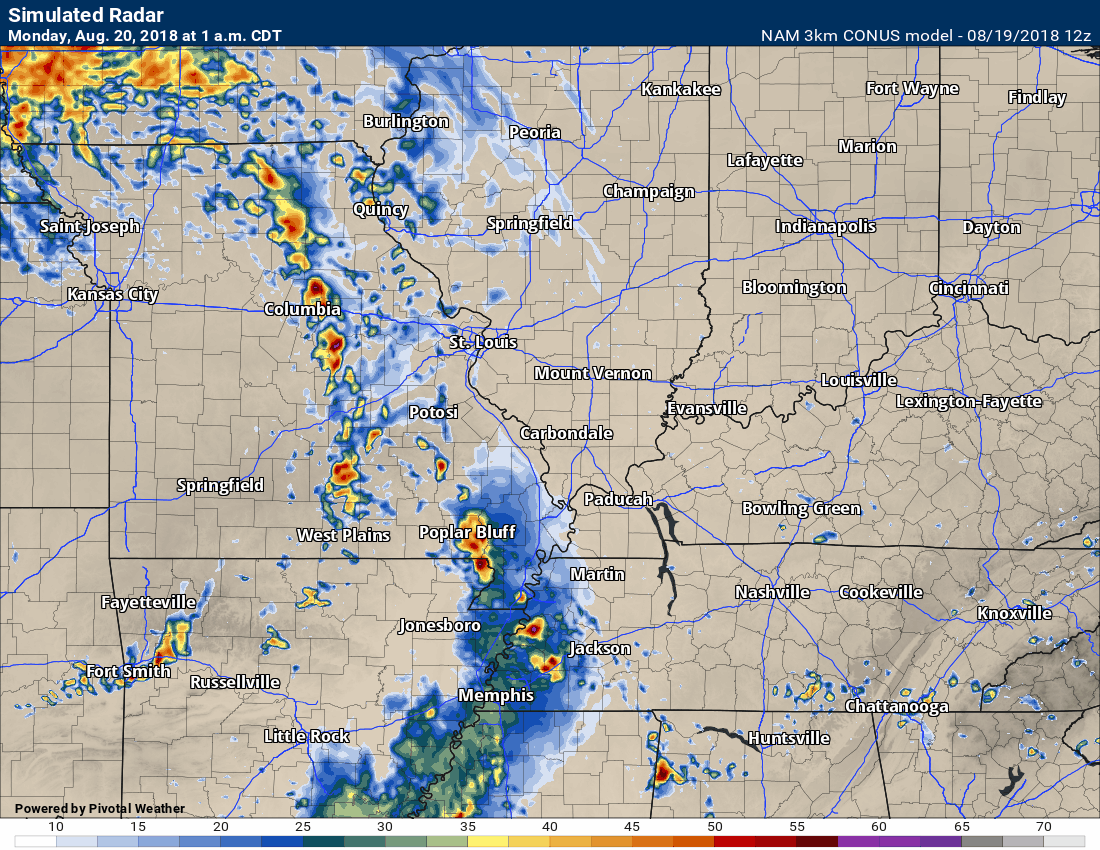
Let’s take a look at two model animation.
These are future-cast radar graphics. What radar might look like over the coming 24 to 36 hours.
The time stamp is located in the upper left corner of the animations.
Click images to enlarge
SPC WRF model
NAM 3K model
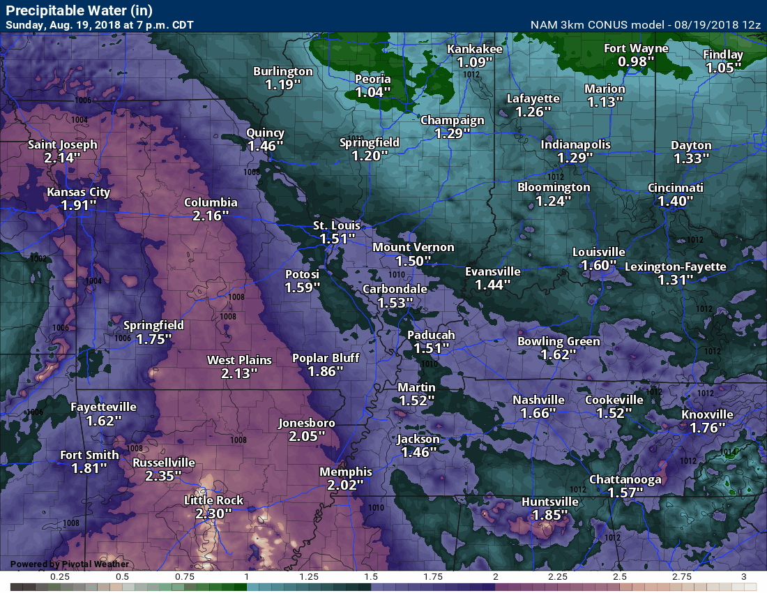
An area of low pressure will pass to our north Monday afternoon and evening. This will help pull southerly winds back into our region. That in turn means increasing dew points and moisture levels.
PWAT values (a measure of moisture) will again increase across the region. This will help support locally heavy downpours.
Here is the PWAT animation. Notice the peak of high numbers ahead of the cold front. Anything about 1.7 is considered high. PWAT values above 2″ are extremely high. That simply means that thunderstorms have plenty of moisture to tap into.
Click to enlarge. Time-stamp is located in the upper left corner of the animation.
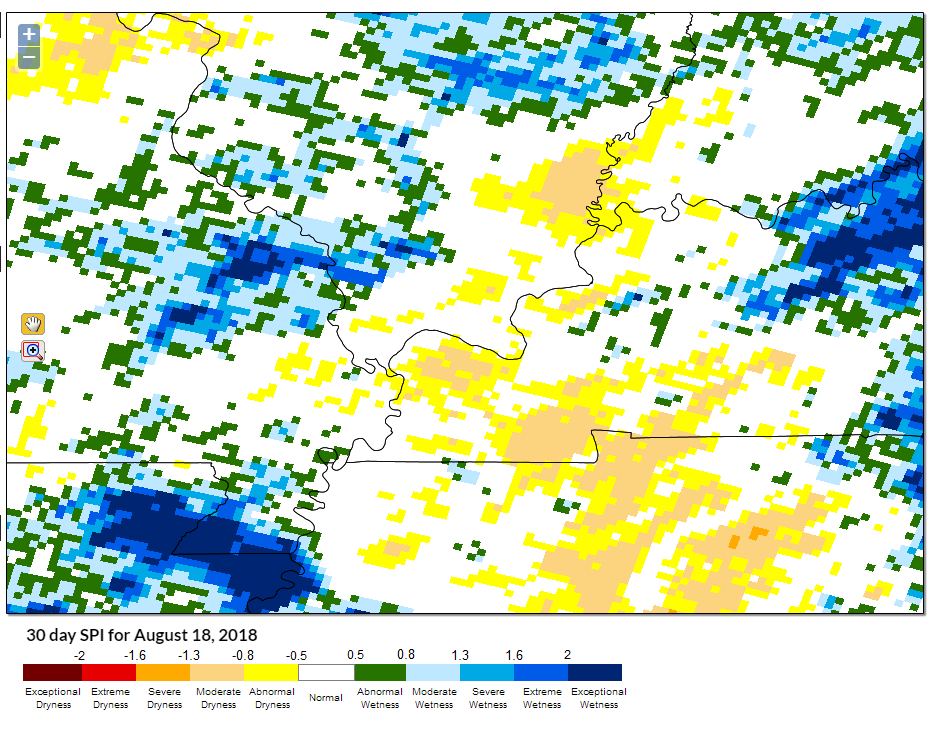
Much of the region has received between 0.75″ to 2″ of rain since last Tuesday. There are some areas where almost no rain has fallen.
This is the last in the series of rain makers. If you miss out on this rain event then you will have to wait until at least the end of the week. Drought is a problem in some areas.
Here is the 30 day SPI index. The SPI index is great for monitoring short term drought conditions. White is neutral. Blue is wetter than normal. Yellow and orange are areas that need rain.
This is about right based on latest rain totals. Some areas not shaded could be drier than normal. You get the overall idea.
![]()

A new weather podcast is now available! Weather Geeks (which you might remember is on The Weather Channel each Sunday)
To learn more visit their website. Click here.
![]()

WeatherBrains Episode 656
Tonight’s Guest WeatherBrain served for nearly 30 years in Emergency Management in Alabama including stints under five governors. He served on the cabinets of two Alabama governors. For nearly seven years, he was the Director of the Alabama Emergency Management Agency. Today, he is the Managing Partner at Blue Skies Business Group.
Other discussions in this weekly podcast include topics like:
- Extremes: 112 at Death Valley, CA, and 33 at Bodie State Park, CA
- Disturbed area in North Atlantic not expected to develop
- SPC has only marginal risk areas next two days
- Still hot in Southwest US
- Trough still along East Coast
- Heavy rain NY and PA today
- Astronomy Outlook with Tony Rice
- and more!
Link to web-site https://weatherbrains.com/
Previous episodes can be viewed by clicking here.
We offer interactive local city live radars and regional radars. If a radar does not update then try another one. If a radar does not appear to be refreshing then hit Ctrl F5. You may also try restarting your browser.
The local city view radars also have clickable warnings.
During the winter months, you can track snow and ice by clicking the winterize button on the local city view interactive radars.
You may email me at beaudodson@usawx.com
Find me on Facebook!

Find me on Twitter!

Did you know that a portion of your monthly subscription helps support local charity projects?
You can learn more about those projects by visiting the Shadow Angel Foundation website and the Beau Dodson News website.

I encourage subscribers to use the app vs regular text messaging. We have found text messaging to be delayed during severe weather. The app typically will receive the messages instantly. I recommend people have three to four methods of receiving their severe weather information.
Remember, my app and text alerts are hand typed and not computer generated. You are being given personal attention during significant weather events.
