We have some great sponsors for the Weather Talk Blog. Please let our sponsors know that you appreciate their support for the Weather Talk Blog.
Milner and Orr Funeral Home and Cremation Services located in Paducah, Kentucky and three other western Kentucky towns – at Milner and Orr they believe in families helping families. You can find Milner and Orr on Facebook, as well.
![]()
.

Wortham Dental Care located in Paducah, Kentucky. The gentle dentist. Mercury free dentistry. They also do safe Mercury removal. You can find Wortham Dental Care on Facebook, as well
.

Trover’s Equipment and Lawn Care – Family owned and operated! They are a dealer for Snapper, Simplicity, Snapper Pro, Bad Boy Mowers, and Intimidator Utility Vehicles. They are a Stihl and Dolmar power products dealer. They also are a dealer for Briggs & Stratton, Kohler gas & diesel engines, and Kawasaki engines. They service and repair just about any brand. You can find them on Facebook, as well
.

Visit their web-site here. Or, you can also visit their Facebook page.
.

Endrizzi’s Storm Shelters – For more information click here. Endrizzi Contracting and Landscaping can be found on Facebook, as well – click here
.
Are you looking for a full service insurance agency that writes homes, businesses, and vehicles in Illinois, Kentucky, and Tennessee. Call Gary’s office at 270.442.8234 for rates and plans to protect what matters to you!

Gary Eckelkamp’s web-site click the above banner or click here
.

This forecast update covers far southern Illinois, far southeast Missouri, and far western Kentucky. See the coverage map on the right side of the blog.
Remember that weather evolves. Check back frequently for updates, especially during active weather.
The forecast numbers below may vary a bit across the region. These are the averages.
Sunday night – Just a few clouds. Mild. An evening shower or thunderstorm possible.
Temperatures: Lows in the middle to upper 60’s .
Winds: Southeast winds at 5 mph.
My confidence in this part of the forecast verifying is high
Should I cancel my outdoor plans? No
Is severe weather expected? No
What is the chance for precipitation? 10%–20% early
What impact is expected? No widespread impacts anticipated
Monday – Partly sunny. A shower or thunderstorm possible. More widespread over our eastern and southeastern counties.
Temperatures: Highs in the middle to upper 80’s
Winds: South winds at 5-10 mph.
My confidence in this part of the forecast verifying is medium
Should I cancel my outdoor plans? No, but monitor radars. Some precipitation will be possible.
Is severe weather expected? No
What is the chance for precipitation? 30%-40% (higher chances eastern counties)
What impact is expected? If storms form then a brief downpour. Gusty winds. Lightning.
Monday night – Partly cloudy. A chance for scattered showers and thunderstorms.
Temperatures: Lows in the upper 60’s .
Winds: South/southeast winds at 5 mph.
My confidence in this part of the forecast verifying is high
Should I cancel my outdoor plans? No, but monitor radars because some storms are possible.
Is severe weather expected? No
What is the chance for precipitation? 30% early and 20% late.
What impact is expected? If storms form then a brief downpour. Gusty winds. Lightning.
Tuesday – Partly sunny. A shower or thunderstorm possible. A strong storm possible over our western counties late Tuesday afternoon and evening.
Temperatures: Highs in the middle to upper 80’s
Winds: South winds at 5-10 mph.
My confidence in this part of the forecast verifying is high
Should I cancel my outdoor plans? No, but monitor radars. Some precipitation will be possible.
Is severe weather expected? Risk is not zero, but isn’t great
What is the chance for precipitation? 30%-40%
What impact is expected? If storms form then a brief downpour. Gusty winds. Lightning.
Tuesday night – Partly cloudy. A chance for scattered showers and thunderstorms.
Temperatures: Lows in the upper 60’s to lower 70’s.
Winds: South/southeast winds at 5 mph.
My confidence in this part of the forecast verifying is high
Should I cancel my outdoor plans? No, but monitor radars because some storms are possible.
Is severe weather expected? Small chance for an isolated severe storm. Mainly over southeast Missouri and southwest Illinois. Small risk.
What is the chance for precipitation? 30%-40%.
What impact is expected? If storms form then a brief downpour. Gusty winds. Lightning.
Wednesday – Increasingly cloudy. Scattered showers and thunderstorms becoming likely. Locally heavy downpours and a few strong storms possible.
Temperatures: Highs in the middle to upper 80’s
Winds: South winds at 10-15 mph and gusty at times.
My confidence in this part of the forecast verifying is high
Should I cancel my outdoor plans? I would have a back up plan.
Is severe weather expected? A few severe storms can’t be ruled out.
What is the chance for precipitation? 60%-70%
What impact is expected? Locally heavy rain, strong winds, frequent lightning, and a few reports of hail possible.
Wednesday night – Cloudy with showers and thunderstorms possible. A few storms could be strong during the evening hours.
Temperatures: Lows in the middle 60’s.
Winds: Southwest winds becoming west and northwest behind the cold front at 10-15 mph. Gusty at times.
My confidence in this part of the forecast verifying is high
Should I cancel my outdoor plans? I would have a back up plan.
Is severe weather expected? A few severe storms possible.
What is the chance for precipitation? 60%
What impact is expected? Locally heavy rain, strong winds, frequent lightning, and a few reports of hail possible.
Thursday – Partly cloudy and not as humid.
Temperatures: Highs in the upper 70’s to lower 80’s
Winds: North/northwest winds at 5-15 mph.
My confidence in this part of the forecast verifying is high
Should I cancel my outdoor plans? No
Is severe weather expected? No
What is the chance for precipitation? 10%
What impact is expected? Not expecting significant impacts from weather.
Thursday night – Mostly clear. Cooler.
Temperatures: Lows in the upper 50’s and lower 60’s.
Winds: Northwest winds at 5-10 mph.
My confidence in this part of the forecast verifying is high
Should I cancel my outdoor plans? No
Is severe weather expected? No
What is the chance for precipitation? 0%
What impact is expected? None
Friday – Partly cloudy and not as humid. Small chance for a shower.
Temperatures: Highs in the upper 70’s to lower 80’s
Winds: Northeast/east winds at 5-10 mph.
My confidence in this part of the forecast verifying is medium
Should I cancel my outdoor plans? No
Is severe weather expected? No
What is the chance for precipitation? 10%-20%
What impact is expected? Not expecting significant impacts from weather.

![]()
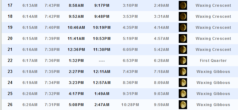
Sunrise and Sunset Times – Click Here


Don’t forget to check out the Southern Illinois Weather Observatory web-site for weather maps, tower cams, scanner feeds, radars, and much more! Click here

An explanation of what is happening in the atmosphere over the coming days…
Highlights
1. A bit more active weather this week
2. Potential for some strong storms on Wednesday
3. What about late week into the weekend? Mixed signals on the data
No, it is not time for a winter forecast. I guess there is a race this year to put out winter forecasts. 🙂 I am watching trends. I am watching El Nino. I am watching the PDO. I am watching everything, but too soon for winter forecasts. By October I will have some ideas on how I believe the winter will unfold. Now, everyone just put on a little patience and let’s concentrate on summer!
I will tell you this. If you see someone making a winter forecast based on El Nino then I would advise you to use caution with that forecast. There is so much more that goes into winter forecasts than just La Nina or El Nino. It is but one small part of a long range forecast. And, I remind you that long range forecasting is typically for entertainment purposes only. Nobody can forecast specific events months in advance. And, it is the specific events that you really want to know about.
Welcome to a new week of weather! We are going to see an increase in dew points over the coming days. That means that it will feel a bit more sticky outside. The good news is that clouds will help keep temperatures from becoming too hot.
We will have a chance for thunderstorms just about every day this week. There is a lower than normal confidence on the late week into the weekend forecast. Unfortunately, the data is all over the place with the potential of yet another cold front around Friday night and Saturday.
Let’s break it down…
Monday will bring a mix of sun and clouds. We are going to see southerly winds return to the region and that will pump a bit more moisture into the region. We will have a weak disturbance over the region. This will help pop a few showers and thunderstorms. The best coverage will be on Monday afternoon and evening. Expect 30%-40% chances. Thought about going a bit higher in the probability numbers, but left it alone.
A 30%-40% chance means that some areas will remain dry. That would be a 3/4 out of 10 chance for picking up some rain at your house.
Monday night into Tuesday we could still have some showers and thunderstorms around. Perhaps the chance goes down a bit on Tuesday compared with Monday. But, still a 20%-30% shot at precipitation.
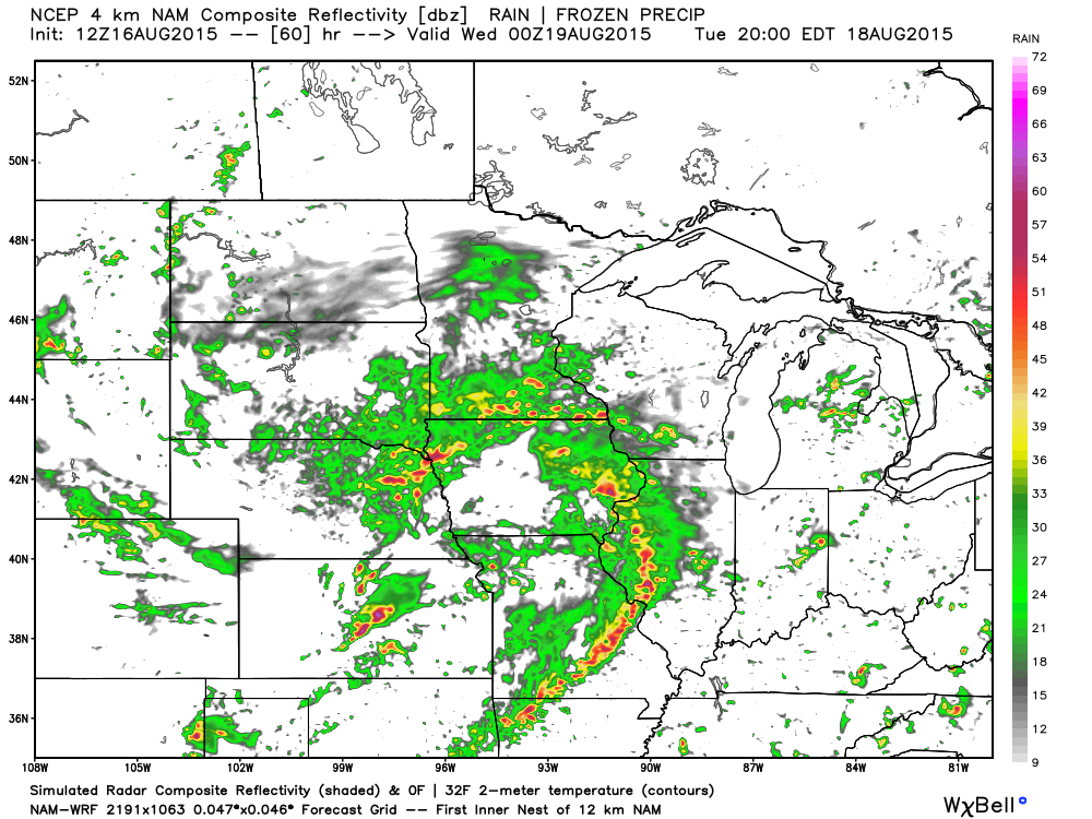
Tuesday night we might see a line of storms approaching from the west. It would first track into southeast Missouri. How long it holds together is still a bit of a question. A few strong storms can’t be ruled out with the line.
Let’s look at the high resolution WRF model for Tuesday evening. See that line of storms? But, can it hold together through the area? Most likely it will be in a weakening stage. But, at least a chance for some storms in the area. This is well ahead of the cold front on Tuesday evening.
By Wednesday a strong cold front approaches the region from the west. This is a rather unusual system for August. A deep area of low pressure is forecast to track well to our north. Something more typical of September or October rather than August.
Wind fields will increase on Wednesday. This combined with instability could mean some pockets of strong storms. I can’t rule out severe weather. The risk for severe weather at any given point appears fairly low. Let’s keep an eye on Wednesday.
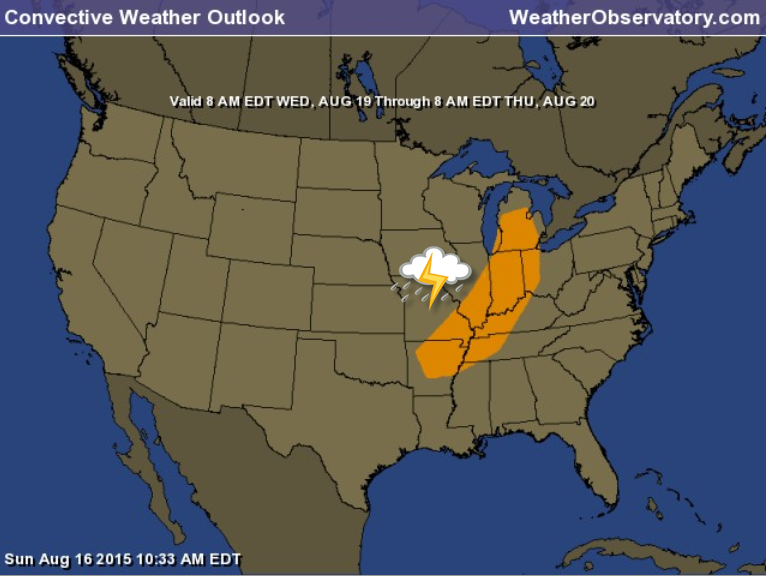
Here is the official severe weather outlook for Wednesday from the Storm Prediction Center. The area in orange is currently outlined for the potential of strong storms (maybe even a few severe thunderstorms). I will keep an eye on it.
If severe weather would occur then the main concern would be damaging wind gusts with a few storms. Secondary concern would be a few reports of hail. The tornado risk is minimal.
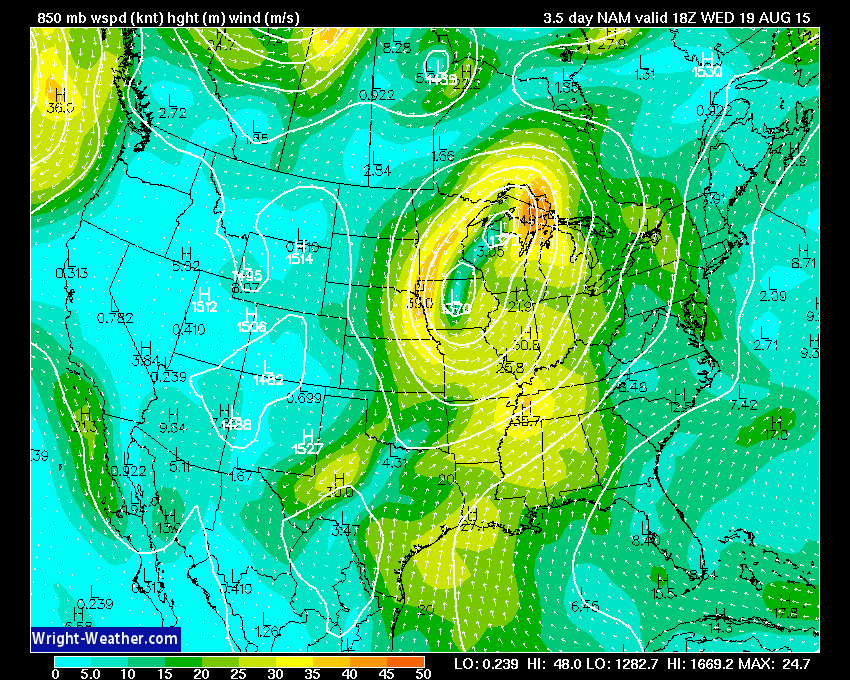
Here are a few maps from wright-weather.com
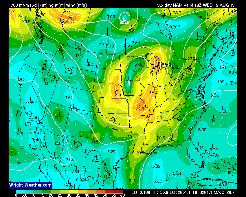
Let’s look at the wind fields at the 850 mb level, 700 mb level, and 500 mb level. Those are different heights in the atmosphere (several thousand feet above the surface). When you have increasing wind fields along a cold front then you have to start to think about a few severe thunderstorms or at least stronger storms.
First, let’s take a look at the 850 mb wind fields.
These are not crazy numbers, by any means. 850 mb wind fields are in the 20-35 knot range. Sufficient for thunderstorms, no doubt. But, not extreme.
The 700 mb winds are a bit higher (as you would expect since you are going up into the atmosphere…winds will increase).
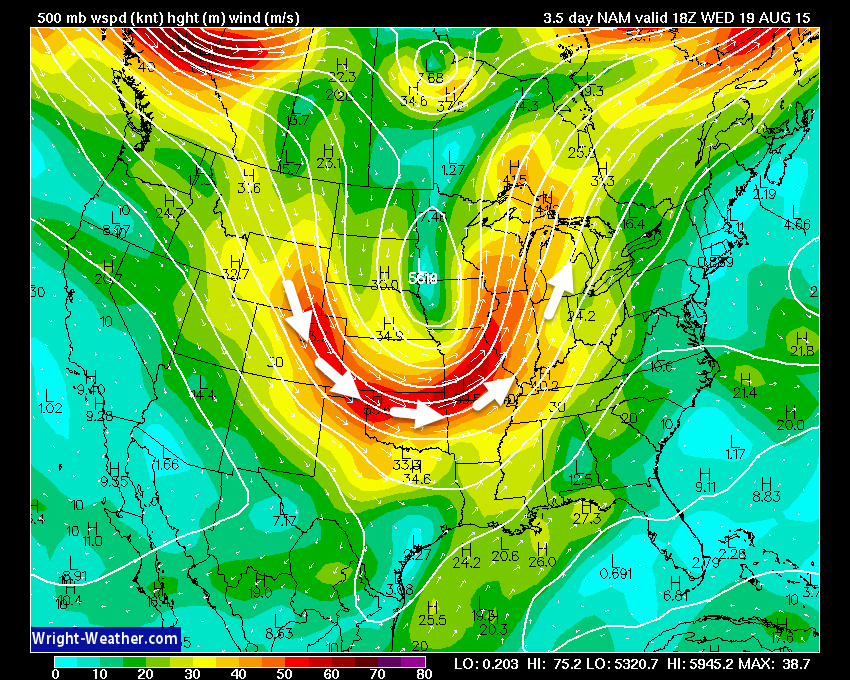
Now the 500 mb level. These are strong winds for August. Not your typical August weather map. But, what has been typical about this summer? You can see the curve of the trough as it digs into our region. A trough usually means unsettled weather. A ridge typically means nicer weather.
By the way, last week the GFS showed a large ridge over us for this week. Another grand failure by that model. Par for the course for the GFS. Ever since they fixed it…it has been broken. Go figure!
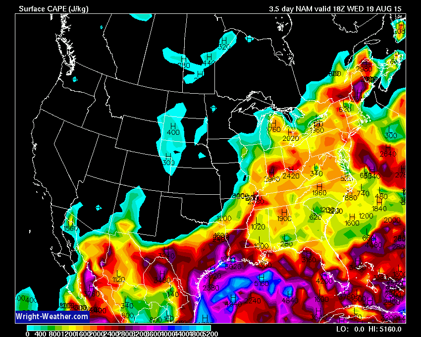
Let’s look at CAPE values for Wednesday. CAPE basically is energy for storms. We can see quite a bit of energy around by Wednesday afternoon.
That is sommmmeeee trough for August (movie reference)! A nice dip in the jet stream. Trough in the Central United States. Impressive.

This is what the weather map will look like on Wednesday morning. Deep area of low pressure over Minnesota and Wisconsin. This is rather unusual for August. We normally don’t see these type of systems in the middle of August. But, yet…there it is!
Remember, low pressure rotates counter-clockwise. Thus, while we are ahead of the cold front we will experience southerly air and moisture streaming northward towards the area of low pressure.
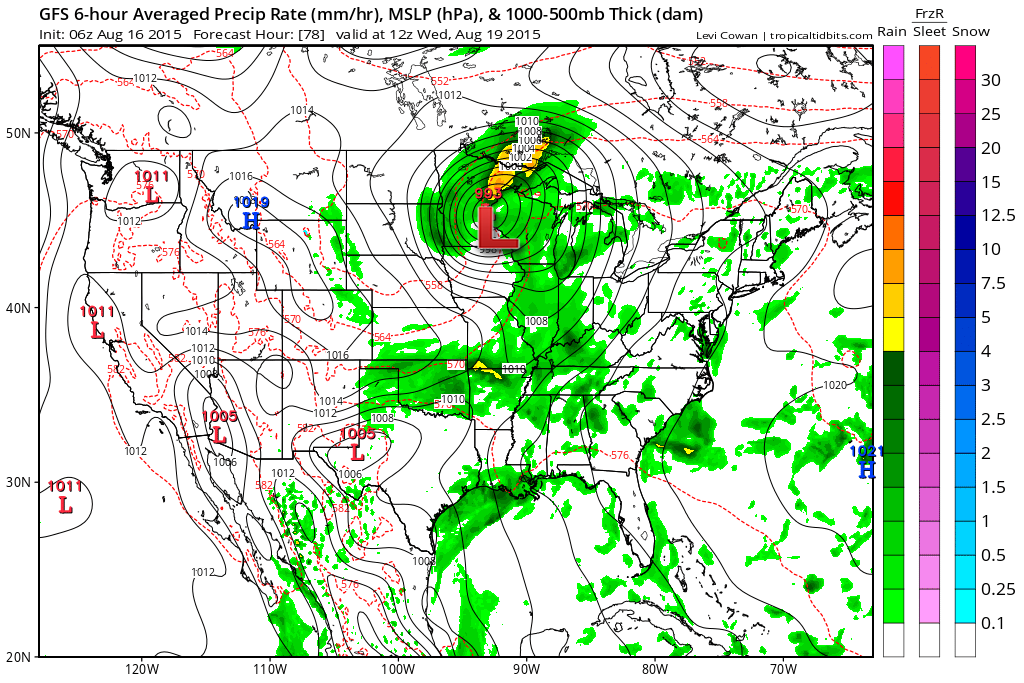
A cold front will trail from that low into Kansas and Oklahoma. The front will push eastward during the day.
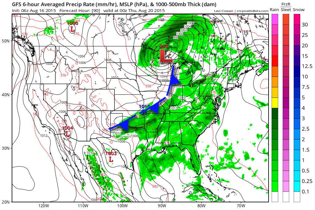
Here is the Wednesday afternoon weather map. The low continues to push east/northeast. The front continues to push into our region. It will bump into the warm and humid air and help produce showers and thunderstorms. Fairly widespread, at that.
Locally heavy rainfall will be possible with storms at any given point this week.
Again, the most widespread precipitation is forecast to fall on Wednesday and Wednesday night.
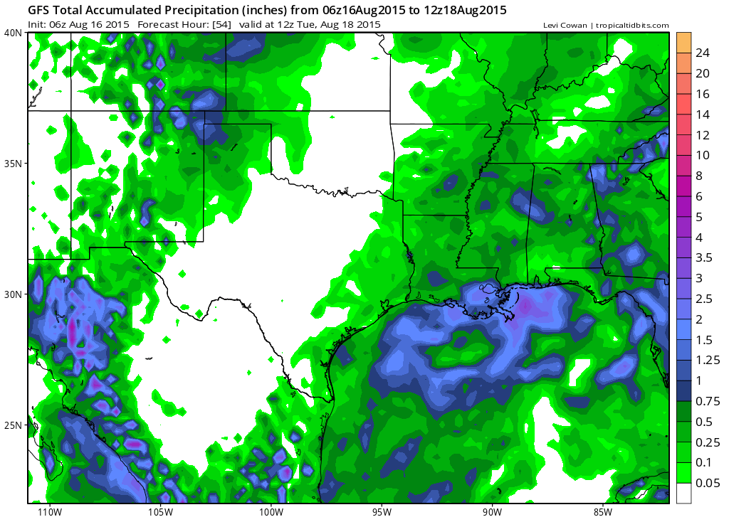
Let’s look at the GFS for rainfall totals. I do trust the GFS on this particular topic. You can see through Tuesday morning some 0.25″-0.50″ numbers. Image is from Tropical Tidbits
Click image for a larger view
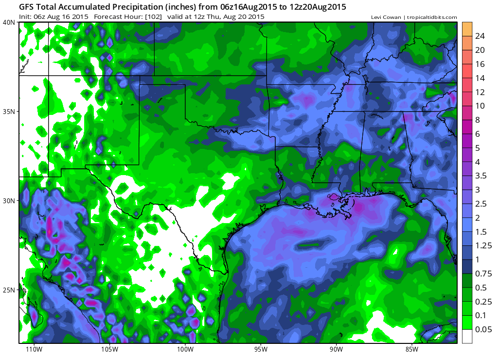
Then moving ahead through Thursday morning (this includes the entire week). You can see quite a few spots of 1″+ over our region. Even some 2″ spots in purple.
Question marks start to appear in the charts as we push towards Friday and Saturday. Models are attempting to bring southerly winds back into the region and yet another cold front. Lower than normal confidence on how the late week time frame plays out. I will be monitoring trends.
The front that moves through on Wednesday may actually stall out over the region next week. I will keep an eye on it.
With clouds and on/off precipitation we will see temperatures stay in check all week. Perhaps below normal on several days. Highs in the middle to upper 80’s ahead of the cold front and lower to middle 80’s behind the front (by Thursday and Friday).
If the cold front does sweep through the region on Wednesday/Wednesday night then below normal temperatures are likely on Thursday into at least Friday. Par for the course this month! Much of the Ohio Valley has been below normal in the temperature department.
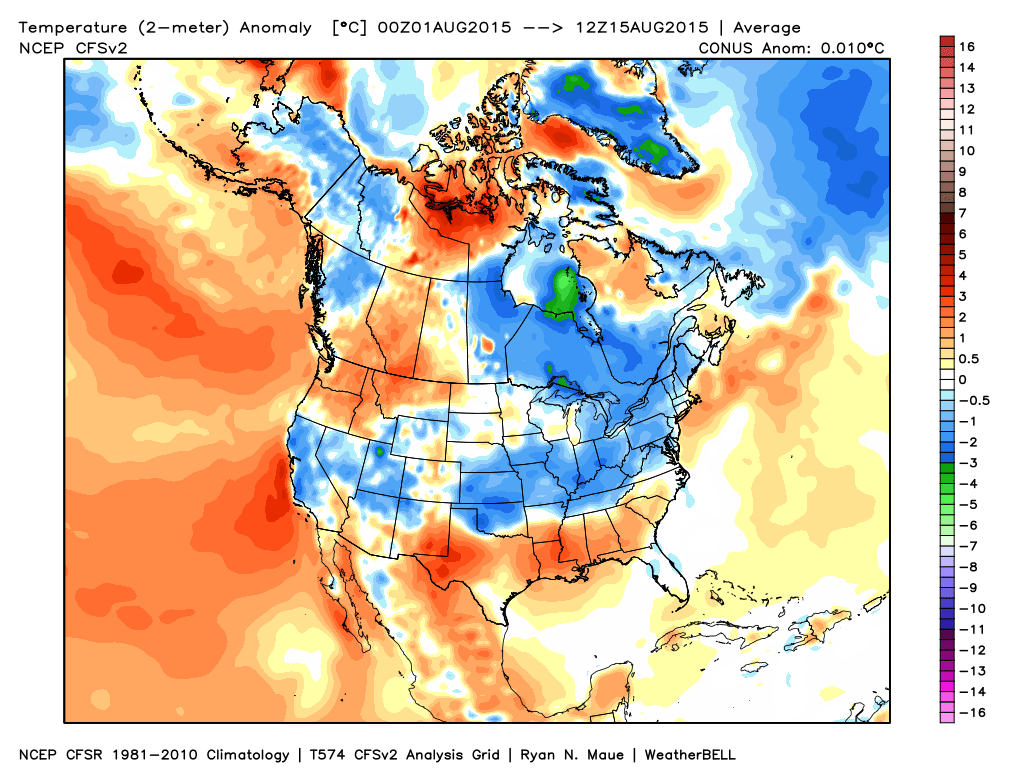
Speaking of below normal temperatures. Let’s examine the month to date temperature anomaly map. Woowee just look at all of that blue! Blue represents below normal temperatures. Again, this is what has already happened the first 15 days of the month.
Image is from weatherbell.com
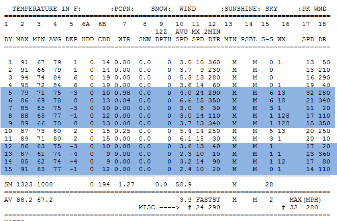
And for good measure. Let’s pull up the actual observations from the Paducah, Kentucky NWS. I forecasted at least 50% of the month to be at or below normal in the temperature department. So far, this is the results. Still a couple of weeks to go! The blue indicates at or below normal temperatures. A good chunk of days have been at or below normal. Nice days, so far.
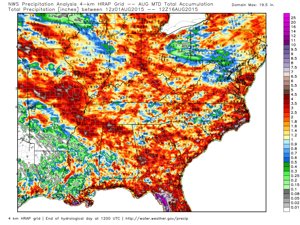
How much precipitation has fallen this month? Good question. Let’s take a look at this WeatherBell.com map (scale is on the right)
Click image for a larger view
Radars
WEATHER RADAR PAGE – Click here —
Don’t forget to support our sponsors!

How much precipitation should we expect over the next few days?
I am expecting rain to fall over the region this week. Several chances. The best chance might arrive on Wednesday and Wednesday night. This will be along a cold front.
At least scattered chances for thunderstorms on Monday, Tuesday, Thursday, Friday, and Saturday. Some data pop another cold front for next weekend. If that happens then there would be an increase in thunderstorm coverage.
Locally heavy rain will be possible with thunderstorms over the coming days. I suspect some places will remain dry on Monday and Tuesday. Scattered reports of 0.25″-0.50″ of rain will be possible. Locally heavier totals likely in the heaviest of storms. Typical for summer.
A more widespread rain event is possible on Wednesday and Wednesday night. This will be associated with a cold frontal passage. Expect totals of 0.25″-0.50″ to be a bit more widespread in nature. Locally there could be 1″ or more in the heaviest thunderstorms.
Thursday into the weekend will bring at least chances for showers and thunderstorms. Again, locally heavy rain will be possible.
Between now and next Sunday many spots could pick up 0.50″-0.75″ of rainfall. Pockets of 1-2″ of rain in localized areas.

Can we expect severe thunderstorms over the next 24 to 48 hours? Remember that a severe thunderstorm is defined as a thunderstorm that produces 58 mph winds or higher, quarter size hail or larger, and/or a tornado.
Thunderstorm threat level will be TWO on Monday. Small risk for an isolated severe thunderstorm.
.
Monday: A few storms possible
Tuesday: A few storms possible
Wednesday: A few storms could approach severe levels. Monitor updates.
Thursday: A few storms possible
Friday: A few storms possible
Saturday: A few storms possible


Some scattered storms possible this week. Much of the week, as a matter of fact. I can’t rule out stronger storms on Wednesday. Monitor updates as we move forward.
Locally heavy rain will be possible this week, as well. Lightning is always a concern for outdoor events.

I also set up a storm tracking page with additional links (use during active weather for quick reference)
Storm Tracking Tool Page

Here are the current river stage forecasts. You can click your state and then the dot for your location. It will bring up the full forecast and hydrograph.
Click Here For River Stage Forecasts…
Here are some current forecast hydrographs. These will be updated each day with new information.


Smithland Lock and Dam

Paducah, Kentucky Forecast Stage

Cairo, Illinois

Cape Girardeau, Missouri
Current Temperatures Around The Local Area


We have regional radars and local city radars – if a radar does not seem to be updating then try another one. Occasional browsers need their cache cleared. You may also try restarting your browser. That usually fixes the problem. Occasionally we do have a radar go down. That is why I have duplicates. Thus, if one fails then try another one.
If you have any problems then please send me an email beaudodson@usawx.com
WEATHER RADAR PAGE – Click here —
We also have a new national interactive radar – you can view that radar by clicking here.
Local interactive city radars include St Louis, Mt Vernon, Evansville, Poplar Bluff, Cape Girardeau, Marion, Paducah, Hopkinsville, Memphis, Nashville, Dyersburg, and all of eastern Kentucky – these are interactive radars. Local city radars – click here
NOTE: Occasionally you will see ground clutter on the radar (these are false echoes). Normally they show up close to the radar sites – including Paducah.

Regional Radar – Click on radar to take you our full radar page.


Regional Radar

Live Lightning Data – zoom and pan: Click here
Live Lightning Data with sound (click the sound button on the left side of the page): Click here
I also set up a storm tracking page with additional links (use during active weather for quick reference)
Storm Tracking Tool Page
![]()
Current WARNINGS (a warning means take action now). Click on your county to drill down to the latest warning information. Keep in mind that there can be a 2-3 minute delay in the updated warning information.
I strongly encourage you to use a NOAA Weather Radio or warning cell phone app for the most up to date warning information. Nothing is faster than a NOAA weather radio.


Color shaded counties are under some type of watch, warning, advisory, or special weather statement. Click your county to view the latest information.

Missouri Warnings

Illinois Warnings

Kentucky Warnings

Here is the official 6-10 day and 8-14 day temperature and precipitation outlook. Check the date stamp at the top of each image (so you understand the time frame).
The forecast maps below are issued by the Weather Prediction Center (NOAA).


The latest 8-14 day temperature and precipitation outlook. Note the dates are at the top of the image. These maps DO NOT tell you how high or low temperatures or precipitation will be. They simply give you the probability as to whether temperatures or precipitation will be above or below normal.


Who do you trust for your weather information and who holds them accountable?
I have studied weather in our region since the late 1970’s. I have 37 years of experience in observing our regions weather patterns. My degree is in Broadcast Meteorology from Mississippi State University and an Associate of Science (AS). I am currently working on my Bachelor’s Degree in Geoscience. Just need to finish two Spanish classes!
I am a member of the American Meteorological Society. I am a NOAA Weather-Ready Nation Ambassador. And, I am the Meteorologist for McCracken County Emergency Management.
I own and operate the Southern Illinois Weather Observatory.
There is a lot of noise on the internet. A lot of weather maps are posted without explanation. Over time you should learn who to trust for your weather information.
My forecast philosophy is simple and straight forward.
- Communicate in simple terms
- To be as accurate as possible within a reasonable time frame before an event
- Interact with you on Twitter, Facebook, and the blog
- Minimize the “hype” that you might see on television or through other weather sources
- Push you towards utilizing wall-to-wall LOCAL TV coverage during severe weather events
I am a recipient of the Mark Trail Award, WPSD Six Who Make A Difference Award, Kentucky Colonel, and the Caesar J. Fiamma” Award from the American Red Cross. In 2009 I was presented with the Kentucky Office of Highway Safety Award. I was recognized by the Kentucky House of Representatives for my service to the State of Kentucky leading up to several winter storms and severe weather outbreaks.
If you click on the image below you can read the Kentucky House of Representatives Resolution.

I am also President of the Shadow Angel Foundation which serves portions of western Kentucky and southern Illinois.
Many of my graphics are from www.weatherbell.com – a great resource for weather data, model data, and more


You can sign up for my AWARE email by clicking here I typically send out AWARE emails before severe weather, winter storms, or other active weather situations. I do not email watches or warnings. The emails are a basic “heads up” concerning incoming weather conditions.