Click schedule for a larger view. Keep in mind, during active weather this schedule will change. There will be additional updates outside of what has been posted here.


We offer interactive local city view radars and regional radars.
If a radar does not update then try another one. If a radar does not appear to be refreshing then hit Ctrl F5. You may also try restarting your browser.

Interactive Radars:
Interactive live weather radar page. Choose the city nearest your location. If one of the city radars won’t load then try a nearby one. Click here.
August 14, 2018
Tuesday Forecast Details
Forecast: A mix of sun and clouds. Scattered showers and thunderstorms possible. Temperatures will vary based on cloud cover. Greatest rain chances will be across Missouri and Illinois.
Temperatures: MO ~ 83 to 86 IL ~ 86 to 88 KY ~ 86 to 88 TN ~ 86 to 88
What is the chance of precipitation? MO ~ 60% IL ~ 40% to 50% KY ~ 30% TN ~ 20% to 30%
Coverage of precipitation: Widely scattered to scattered (best chance over portions of southeast Missouri and southern Illinois)
Wind: Southwest wind 6 to 12 mph
What impacts are anticipated from the weather? Wet roadways. Lightning. Locally heavy rain where thunderstorms occur.
My confidence in the forecast verifying: High
Is severe weather expected? Summer storms can produce isolated high winds
The NWS defines severe weather as 58 mph wind or great, 1″ hail or larger, and/or tornadoes
Should I cancel my outdoor plans? No, but I would recommend checking radars from time to time
UV Index: 8 to 10 High (3 to 5) in southeast Missouri and southern Illinois
Sunrise: 6:10 AM
Tuesday Night Forecast Details:
Forecast: Mostly cloudy with scattered showers and thunderstorms. Locally heavy rain where thunderstorms occur.
Temperatures: MO ~ 66 to 70 IL ~ 66 to 70 KY ~ 66 to 70 TN ~ 66 to 70
What is the chance of precipitation? MO ~ 40% IL ~ 40% KY ~ 30% TN ~ 20%
Coverage of precipitation: Widely scattered to scattered
Wind: South and southeast at 5 to 10 mph
What impacts are anticipated from the weather? Wet roadways. Lightning. Locally heavy rain where thunderstorms occur. This can temporarily flood ditches.
My confidence in the forecast verifying: High
Is severe weather expected? Summer storms can occasionally produce isolated high winds
The NWS defines severe weather as 58 mph wind or great, 1″ hail or larger, and/or tornadoes
Should I cancel my outdoor plans? No, but I would recommend checking radars.
Sunset: 7:47 PM
Moonrise: 9:46 AM Waxing Crescent
Moonset: 10:14 PM
August 15, 2018
Wednesday Forecast Details
Forecast: Partly sunny with scattered showers and thunderstorms likely. Locally heavy rain where thunderstorms occur. Greatest coverage may again be across Missouri and Illinois.
Temperatures: MO ~ 83 to 88 (coolest readings where clouds are thicker) IL ~ 83 to 86 KY ~ 86 to 88 TN ~ 86 to 88
What is the chance of precipitation? MO ~ 50% to 60% IL ~ 40% to 50% KY ~ 30% to 40% TN ~ 30%
Coverage of precipitation: Scattered to perhaps numerous. Greatest coverage over Missouri and Illinois.
Wind: South and southwest at 7 to 14 mph with gusts to 20 mph
What impacts are anticipated from the weather? Wet roadways. Lightning. Locally heavy rain where thunderstorms occur. This can temporarily flood ditches. Isolated severe weather risk.
My confidence in the forecast verifying: Medium
Is severe weather expected? Summer storms can produce isolated high winds. Isolated severe weather risk
The NWS defines severe weather as 58 mph wind or great, 1″ hail or larger, and/or tornadoes
Should I cancel my outdoor plans? I would have a plan B and monitor forecast updates
UV Index: 4 to 9 (will vary based on clouds)
Sunrise: 6:11 AM
Wednesday Night Forecast Details:
Forecast: Mostly cloudy. Showers and thunderstorms likely. Locally heavy rain with any thunderstorms that develop.
Temperatures: MO ~ 68 to 72 IL ~ 68 to 72 KY ~ 68 to 72 TN ~68 to 72
What is the chance of precipitation? MO ~ 60% to 70% IL ~ 60% to 70% KY ~ 60% to 70% TN ~ 60% to 70%
Coverage of precipitation: Numerous
Wind: South and southwest at 6 to 12 mph with gusts to 16 mph
What impacts are anticipated from the weather? Wet roadways. Lightning. Locally heavy rain where thunderstorms occur. This can temporarily flood ditches. Isolated severe weather risk
My confidence in the forecast verifying: Medium
Is severe weather expected? Summer storms can occasionally produce isolated high winds. Isolated severe weather risk
The NWS defines severe weather as 58 mph wind or great, 1″ hail or larger, and/or tornadoes
Should I cancel my outdoor plans? Have a plan B and monitor updated forecasts
Sunset: 7:46 PM
Moonrise: 10:52 AM Waning Crescent
Moonset: 10:47 PM
August 16, 2018
Thursday Forecast Details
Forecast: Quite a few clouds with scattered showers and thunderstorms. Locally heavy rain with any thunderstorms that develop.
Temperatures: MO ~ 84 to 88 IL ~ 84 to 88 KY ~ 84 to 88 TN ~ 85 to 88
What is the chance of precipitation? MO ~ 40% to 50% IL ~ 40% to 50% KY ~ 50% TN ~ 50%
Coverage of precipitation: Scattered to perhaps numerous (esp Pennyrile area of west KY)
Wind: Southwest at 6 to 12 mph with gusts to 15 mph
What impacts are anticipated from the weather? Wet roadways. Lightning. Locally heavy downpours. Isolated severe weather risk.
My confidence in the forecast verifying: Medium
Is severe weather expected? Summer storms can produce isolated high winds. Isolated severe weather risk.
The NWS defines severe weather as 58 mph wind or great, 1″ hail or larger, and/or tornadoes
Should I cancel my outdoor plans? No, but monitor radars
UV Index: 8 to 10 High
Sunrise: 6:12 AM
Thursday Night Forecast Details:
Forecast: Partly cloudy. A chance of scattered showers or thunderstorms.
Temperatures: MO ~ 66 to 70 IL ~ 66 to 68 KY ~ 66 to 68 TN ~ 66 to 72
What is the chance of precipitation? MO ~ 30% IL ~ 30% KY ~ 30% TN ~ 30%
Coverage of precipitation: Widely scattered
Wind: West and southwest at 4 to 8 mph
What impacts are anticipated from the weather? Wet roadways. Lightning.
My confidence in the forecast verifying: Medium
Is severe weather expected? Summer storms can occasionally produce isolated high winds
The NWS defines severe weather as 58 mph wind or great, 1″ hail or larger, and/or tornadoes
Should I cancel my outdoor plans? No, but check radars
Sunset: 7:45 PM
Moonrise: 11:55 AM Waning Crescent
Moonset: 11:20 PM
Confidence in the rain probabilities will be lower as we move into the Friday through Monday time-frame. I will have a better grasp on this as we move through the week.
Monitor updated forecasts.
August 17, 2018
Friday Forecast Details
Forecast: Partly sunny. Scattered thunderstorms again possible. Greatest coverage during the PM hours.
Temperatures: MO ~ 85 to 88 IL ~ 84 to 88 KY ~ 85 to 88 TN ~ 85 to 88
What is the chance of precipitation? MO ~ 30% IL ~ 30% KY ~ 30% TN ~ 30%
Coverage of precipitation: Scattered
Wind: West and northwest at 4 to 8 mph
What impacts are anticipated from the weather? Wet roadways. Lightning. Locally heavy rain.
My confidence in the forecast verifying: Low to medium
Is severe weather expected? Summer storms can produce isolated high winds
The NWS defines severe weather as 58 mph wind or great, 1″ hail or larger, and/or tornadoes
Should I cancel my outdoor plans? No
UV Index: 8 to 10 High
Sunrise: 6:13 AM
Friday Night Forecast Details:
Forecast: Partly cloudy. A chance of scattered showers and thunderstorms.
Temperatures: MO ~ 65 to 70 IL ~ 65 to 68 KY ~ 65 to 68 TN ~ 66 to 72
What is the chance of precipitation? MO ~40% IL ~ 40% to 50% KY ~ 40% TN ~ 40%
Coverage of precipitation: Scattered
Wind: Variable at 5 to 10 mph
What impacts are anticipated from the weather? Wet roadways. Lightning.
My confidence in the forecast verifying: Low to medium
Is severe weather expected? Summer storms can occasionally produce isolated high winds
The NWS defines severe weather as 58 mph wind or great, 1″ hail or larger, and/or tornadoes
Should I cancel my outdoor plans? Monitor updated forecasts
Sunset: 7:44 PM
Moonrise: 12:57 PM Waxing Crescent
Moonset: 11:55 PM
August 18, 2018
Saturday Forecast Details
Forecast: Mostly cloudy with widely scattered showers and thunderstorms.
Temperatures: MO ~ 84 to 88 IL ~ 84 to 88 KY ~ 84 to 88 TN ~ 85 to 88
What is the chance of precipitation? MO ~ 30% to 40% IL ~ 30% to 40% KY ~ 40% to 50% TN ~ 40% to 50%
Coverage of precipitation: Widely scattered
Wind: South and southwest at 5 to 10 mph
What impacts are anticipated from the weather? Wet roadways. Lightning.
My confidence in the forecast verifying: LOW
Is severe weather expected? Summer storms can produce isolated high winds
The NWS defines severe weather as 58 mph wind or great, 1″ hail or larger, and/or tornadoes
Should I cancel my outdoor plans? Monitor updates
UV Index: 8 to 10 High
Sunrise: 6:14 AM
Saturday Night Forecast Details:
Forecast: Partly cloudy with widely scattered showers and thunderstorms.
Temperatures: MO ~ 64 to 66 IL ~ 64 to 66 KY ~ 64 to 68 TN ~ 66 to 72
What is the chance of precipitation? MO ~ 20% IL ~ 20% KY ~ 30% TN ~ 20%
Coverage of precipitation: Widely scattered
Wind: South and southwest at 5 to 10 mph
What impacts are anticipated from the weather? Wet roadways and lightning.
My confidence in the forecast verifying: LOW
Is severe weather expected? Summer storms can occasionally produce isolated high winds
The NWS defines severe weather as 58 mph wind or great, 1″ hail or larger, and/or tornadoes
Should I cancel my outdoor plans? Monitor updates
Sunset: 7:42 PM
Moonrise: 1:56 PM Waxing Crescent
Moonset: 12:01 AM
August 19, 2018
Sunday Forecast Details
Forecast: Partly cloudy with widely scattered showers and thunderstorms again possible.
Temperatures: MO ~ 84 to 88 IL ~ 84 to 88 KY ~ 84 to 88 TN ~ 85 to 88
What is the chance of precipitation? MO ~ 30% IL ~ 30% KY ~ 30% TN ~ 30%
Coverage of precipitation: Widely scattered
Wind: Southwest at 5 to 10 mph
What impacts are anticipated from the weather? Wet roadways and lightning.
My confidence in the forecast verifying: LOW
Is severe weather expected? Summer storms can produce isolated high winds
The NWS defines severe weather as 58 mph wind or great, 1″ hail or larger, and/or tornadoes
Should I cancel my outdoor plans? No, but monitor updated forecasts
UV Index: 8 to 10 High
Sunrise: 6:15 AM
Sunday Night Forecast Details:
Forecast: Partly cloudy with widely scattered showers and thunderstorms again possible.
Temperatures: MO ~ 66 to 70 IL ~ 64 to 68 KY ~ 64 to 68 TN ~ 66 to 72
What is the chance of precipitation? MO ~ 30% IL ~ 30% KY ~ 30% TN ~ 30%
Coverage of precipitation: Widely scattered
Wind: Southwest at 5 to 10 mph
What impacts are anticipated from the weather? Wet roadways and lightning.
My confidence in the forecast verifying: LOW
Is severe weather expected? Summer storms can occasionally produce isolated high winds
The NWS defines severe weather as 58 mph wind or great, 1″ hail or larger, and/or tornadoes
Should I cancel my outdoor plans? No, but check the latest forecast numbers
Sunset: 7:52 PM
Moonrise: 2:53 PM First Quarter
Moonset: 12:33 AM
August 20, 2018
Monday Forecast Details
Forecast: Partly cloudy with scattered showers and thunderstorms again possible.
Temperatures: MO ~ 86 to 90 IL ~ 84 to 88 KY ~ 84 to 88 TN ~ 85 to 88
What is the chance of precipitation? MO ~ 30% to 40% IL ~ 30% to 40% KY ~ 30% to 40% TN ~ 30% to 40%
Coverage of precipitation: Scattered
Wind: Southwest at 5 to 10 mph
What impacts are anticipated from the weather? Wet roadways and lightning. A few intense storms possible.
My confidence in the forecast verifying: LOW
Is severe weather expected? Summer storms can produce isolated high winds. We should monitor Monday for a few stronger storms.
The NWS defines severe weather as 58 mph wind or great, 1″ hail or larger, and/or tornadoes
Should I cancel my outdoor plans?
UV Index: 6 to 8
Sunrise: 6:15 AM
Monday Night Forecast Details:
Forecast: Partly cloudy with scattered showers and thunderstorms again possible.
Temperatures: MO ~ 66 to 70 IL ~ 64 to 68 KY ~ 64 to 68 TN ~ 66 to 72
What is the chance of precipitation? MO ~ 30% to 40% IL ~ 30% to 40% KY ~ 30% to 40% TN ~ 30% to 40%
Coverage of precipitation: Scattered
Wind: Southwest at 5 to 10 mph
What impacts are anticipated from the weather? Wet roadways and lightning. A few intense storms possible.
My confidence in the forecast verifying: LOW
Is severe weather expected? Summer storms can occasionally produce isolated high winds
The NWS defines severe weather as 58 mph wind or great, 1″ hail or larger, and/or tornadoes
Should I cancel my outdoor plans?
Sunset: 7:40 PM
Moonrise: 3:48 PM Waxing Gibbous
Moonset: 1:12 AM
August 21, 2018
Tuesday Forecast Details
Forecast: Partly cloudy with scattered showers and thunderstorms again possible.
Temperatures: MO ~ 84 to 88 IL ~ 84 to 88 KY ~ 84 to 88 TN ~ 84 to 88
What is the chance of precipitation? MO ~ 30% IL ~ 30% KY ~ 30% TN ~ 30%
Coverage of precipitation: Scattered
Wind: Southwest at 5 to 10 mph
What impacts are anticipated from the weather? Wet roadways and lightning.
My confidence in the forecast verifying: LOW
Is severe weather expected? Summer storms can produce isolated high winds
The NWS defines severe weather as 58 mph wind or great, 1″ hail or larger, and/or tornadoes
Should I cancel my outdoor plans?
UV Index: 6 to 8 Medium/High
Sunrise: 6:16 AM
Tuesday Night Forecast Details:
Forecast: Partly cloudy with a shower or thunderstorm possible.
Temperatures: MO ~ 66 to 70 IL ~ 64 to 68 KY ~ 64 to 68 TN ~ 66 to 72
What is the chance of precipitation? MO ~ 20% IL ~ 20% KY ~ 20% TN ~ 20%
Coverage of precipitation:
Wind: Southwest at 5 to 10 mph
What impacts are anticipated from the weather? Wet roadways and lightning.
My confidence in the forecast verifying: LOW
Is severe weather expected? Summer storms can occasionally produce isolated high winds
The NWS defines severe weather as 58 mph wind or great, 1″ hail or larger, and/or tornadoes
Should I cancel my outdoor plans?
Sunset: 7:38 PM
Moonrise: 4:39 PM Waxing Gibbous
Moonset: 1:56 AM

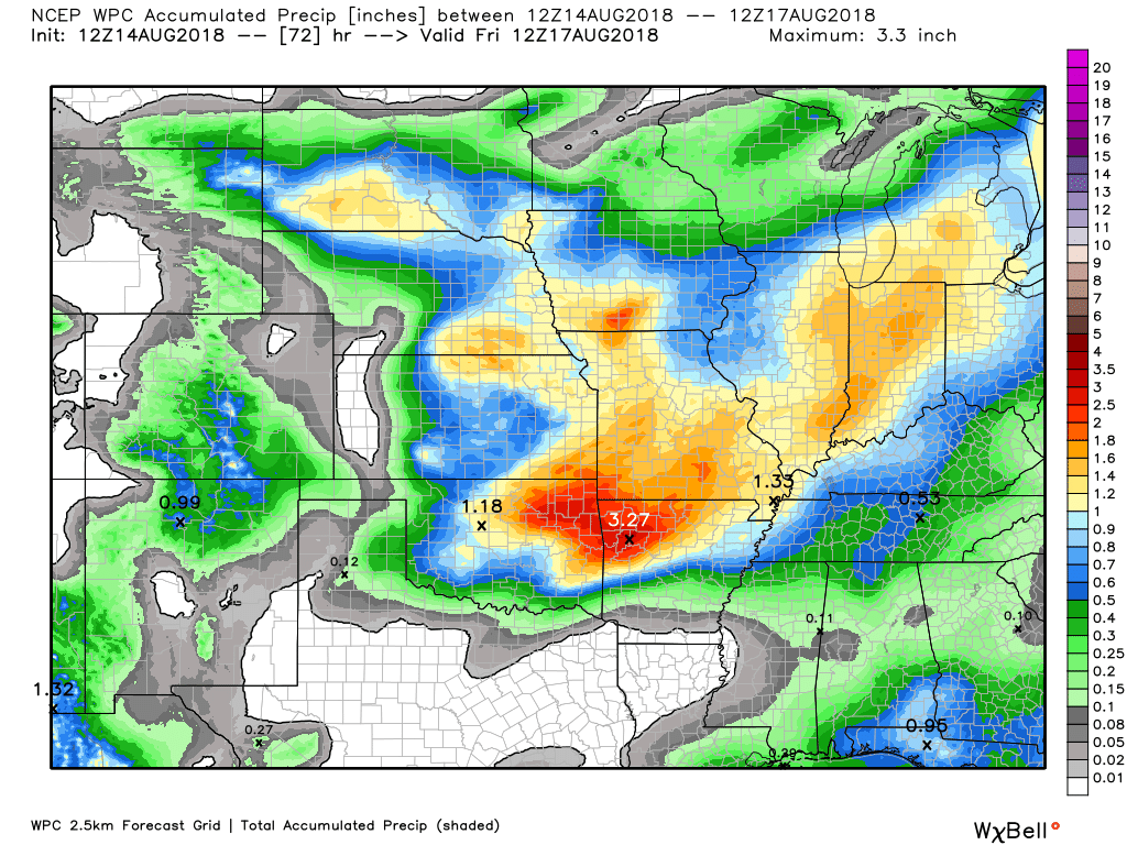
Here is the latest WPC/NOAA rainfall outlook.
Keep in mind, this graphic won’t capture those locally heavy thunderstorms that we often have during the summer months. Those storms can easily drop an inch or more of rain in less than an hour.
Here is the 72-hour rainfall forecast through 7 AM Wednesday
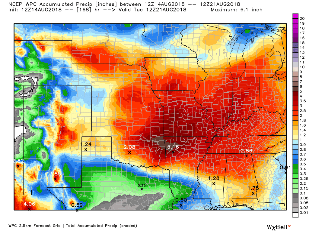
Here is the seven-day rainfall forecast through 7 AM Sunday
A fairly large rain event over the coming days. Some areas will likely top three inches of rain. This is much needed rain for many areas.
This is one of the larger/widespread rain events over the last few months.
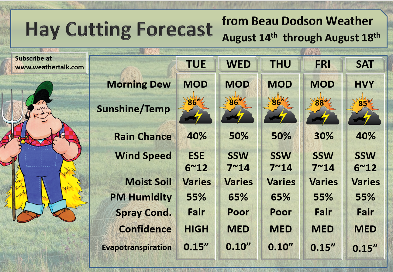
Spray conditions will be mixed. The reason for this is on and off shower and storm chances. It won’t rain everywhere through the period. There will likely be rain on radar into Saturday. Some locally heavy rain likely.

We offer interactive local city live radars and regional radars.
If a radar does not update then try another one. If a radar does not appear to be refreshing then hit Ctrl F5 on your keyboard.
You may also try restarting your browser. The local city view radars also have clickable warnings.
During the winter months, you can track snow and ice by clicking the winterize button on the local city view interactive radars.

Questions? Broken links? Other questions?
You may email me at beaudodson@usawx.com

The National Weather Service defines a severe thunderstorm as one that produces quarter size hail or larger, 58 mph winds or greater, and/or a tornado.
Tuesday through Thursday: Scattered thunderstorms are possible. Storms that form will produce gusty winds, lightning, and locally heavy rain. The threat of severe weather appears low to marginal. I can’t rule out a few reports of wind gusts between 50 and 60 mph. Isolated down-burst winds can occur with summer thunderstorms.
Friday through Monday: Scattered thunderstorms are possible. Storms that form will produce gusty winds, lightning, and locally heavy rain. The best chance of intense thunderstorms may hold off until Monday. This is when a stronger storm system approaches the region.
Summer thunderstorms can produce isolated microbursts.
microburst winds can exceed 50 mph.
What are microbursts?

Interactive live weather radar page. Choose the city nearest your location. If one of the cities does not work then try a nearby one. Click here.
National map of weather watches and warnings. Click here.
Storm Prediction Center. Click here.
Weather Prediction Center. Click here.

Live lightning data: Click here.

Interactive GOES R satellite. Track clouds. Click here.

Here are the latest local river stage forecast numbers Click Here.
Here are the latest lake stage forecast numbers for Kentucky Lake and Lake Barkley Click Here.

- Finally, some decent rain in the forecast.
- Locally heavy rain again possible where thunderstorms occur.
- I can not rule out a few strong thunderstorms, as well.
- Rain chances will linger into early next week.
The September forecast has been updated.
A series of disturbances will push through our region between today and next Monday.
Each of these disturbances will be accompanied by showers and thunderstorms. Locally heavy rain is likely over the coming days.
I would not be surprised if a few locations exceeded three inches of rain between now and Monday night.
The best chance of rain today and tonight will be across southeast Missouri and southern Illinois. The same on Wednesday.
That does not mean it won’t rain elsewhere. The greatest coverage, however, should be over the above mentioned areas.
Rain chances will increase area-wide as we move into Wednesday night and Thursday. Locally heavy rain is likely.
We will have at least a few scattered showers and thunderstorms Thursday night into Friday, as well.
Here is the future-cast radar from the NAM model guidance. This is what the NAM model believes radar will look like over the coming 48 to 60 hours. It won’t be exact. Take the general idea from this graphic.

Another system chugs into the region late Friday afternoon and night. This system lingers into Saturday. This should deliver an increase in shower and thunderstorm activity, as well.
That system will linger into Sunday.
Yet another system moves across the region on Monday. That system will also deliver increasing shower and thunderstorm chances.
Many of you need rain. It appears many of you will receive a decent rain event between now and Monday night.
Temperatures won’t be extreme. Highs will mostly top out in the 84 to 88-degree range right on through the weekend. Overnight lows will dip into the 60’s to around 70 degrees.
Temperatures will be somewhat cooler because of cloud cover. Not sure cool is the right word. Not as hot. How is that?
Wind fields aloft will be fairly tame this week. That should limit the risk of severe weather. A few isolated reports of damaging wind gusts are possible. The main concern would be Wednesday and Thursday and then again next Monday. This is when wind fields aloft will be slightly stronger. Still, nothing extreme.
CAPE (a measure of instability for thunderstorms to tap into) will be marginal for severe weather. Today’s CAPE values will be low.
Those numbers increase a bit on Wednesday and even more so on Thursday. We will need to monitor Thursday since CAPE levels will be higher. Perhaps a few strong thunderstorms (again, isolated high winds).
Wednesday CAPE
Fairly low numbers Wednesday.
CAPE values in the 300 to 1500 range. That is not all that high for the Month of August. In the winter, those numbers would be high.
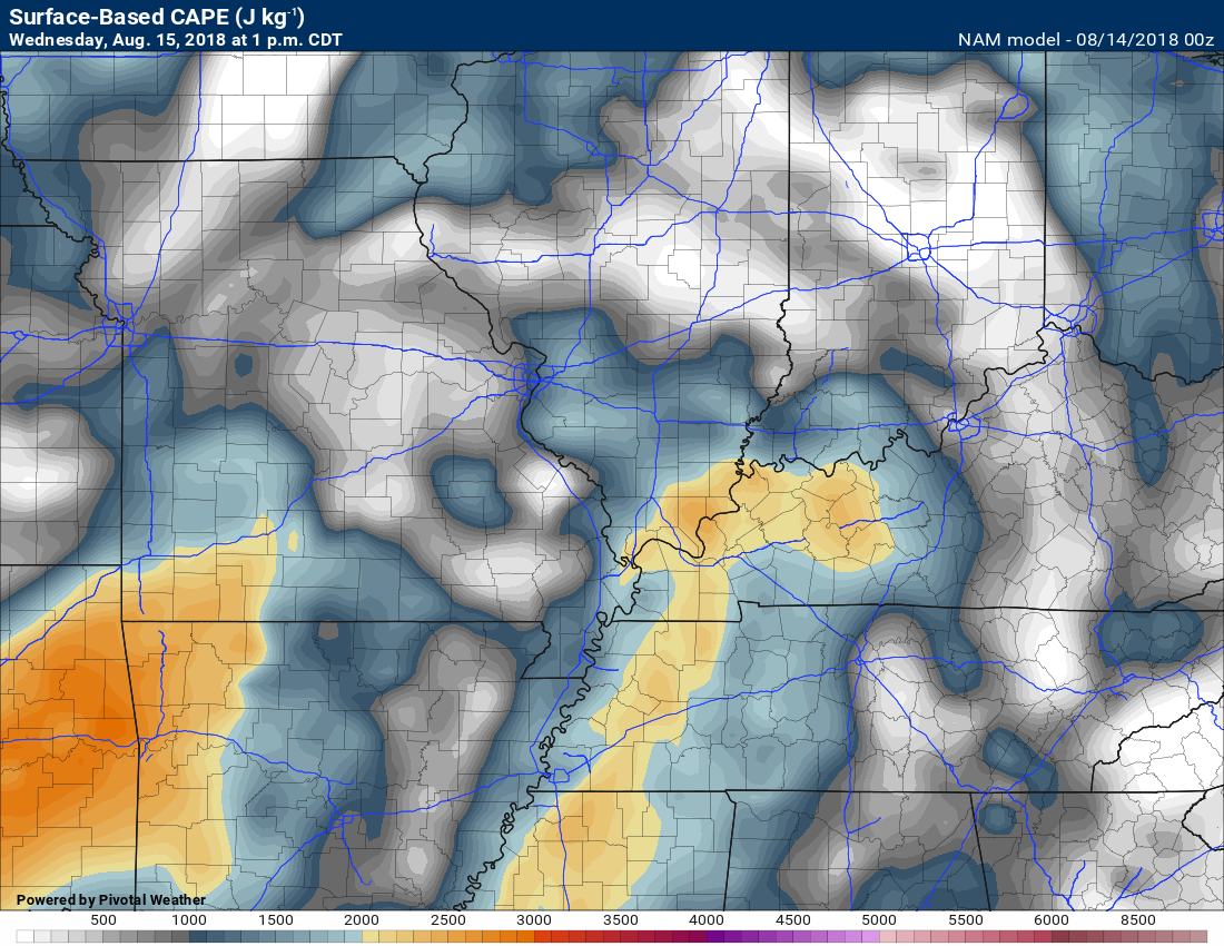
Thursday CAPE numbers via the NAM model guidance.
Thursday’s numbers will be in the 1500 to 3000 range. Perhaps sufficient for a few thunderstorms to produce high winds.
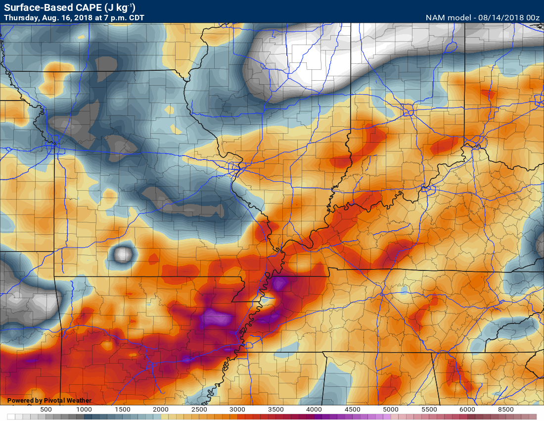
There will be plenty of moisture for thunderstorms to work with. That means locally heavy rain is again on the table.
The low level jet will kick up as we move through the next couple of days. The low level jet will help spread a conveyor belt of moisture into the region.
You can see that animation here (850 mb is about 5000′ aloft). A strong low level jet typically means heavy rain and strong thunderstorms.
The strongest low level jet will be Wednesday afternoon into Thursday.
Time stamp upper left. Click image to enlarge.
You are looking at winds at the 5000′ level (aloft).
PWAT values will range from 1.7 to 2.1″ over the coming days. PWAT is a measure of moisture that thunderstorms tap into. Showers and thunderstorms will be prolific rain producers. Tropical-like.
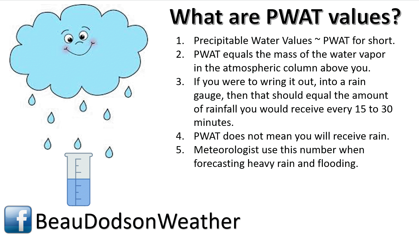
Here is the PWAT animation map from the NAM model guidance. You can see the high numbers moving across our region over the coming days.
This prolonged period of high PWAT values is another indicator that heavy rain will be possible.
Time stamp is located in the upper left portion of the animation. Click to enlarge.
![]()
![]()
These are bonus videos and maps for subscribers. I bring these to you from the BAMwx team. I pay them to help with videos.
The Ohio and Missouri Valley videos cover most of our area. They do not have a specific Tennessee Valley forecast but may add one in the future.
The long-range video is technical. Over time, you can learn a lot about meteorology from the long range video. Just keep in mind, it is a bit more technical.
NOTE: THESE ARE USUALLY NOT UPDATED ON SATURDAY OR SUNDAY.


![]()

I bring these to you from the BAMwx team. They are excellent long-range forecasters.
Remember, long-range outlooks are a bit of skill, understanding weather patterns, and luck combined. It is not an exact science.


![]()
First glance at fall!
Preliminary October precipitation outlook
Here is the preliminary November temperature and precipitation outlook
Preliminary November temperature outlook
Preliminary November precipitation outlook
![]()

![]()

A new weather podcast is now available! Weather Geeks (which you might remember is on The Weather Channel each Sunday)
To learn more visit their website. Click here.
![]()

WeatherBrains Episode 655
This episode features a focus on the upcoming National Weather Association annual meeting August 25 to 30, 2018, in St. Louis, MO.
Joining us are Janice Bunting, Executive Director of the NWA, and Pat Spoden, Hospitality Host for the meeting as well as handling.
The RON! The RON is a special session to try to connect researchers and operational meteorologist.
Other discussions in this weekly podcast include topics like:
- Extremes: 119 at Death Valley, CA, and 28 at West Yellowstone, MT
- Hot along West Coast of US
- Severe storms eastern Colorado Monday evening
- Cooler weather coming to OK and North TX
- 1st all-woman flight crew on hurricane hunter flight into Hector
- Astronomy Outlook with Tony Rice
- and more!
Link to web-site https://weatherbrains.com/
Previous episodes can be viewed by clicking here.
We offer interactive local city live radars and regional radars. If a radar does not update then try another one. If a radar does not appear to be refreshing then hit Ctrl F5. You may also try restarting your browser.
The local city view radars also have clickable warnings.
During the winter months, you can track snow and ice by clicking the winterize button on the local city view interactive radars.
You may email me at beaudodson@usawx.com
Find me on Facebook!

Find me on Twitter!

Did you know that a portion of your monthly subscription helps support local charity projects?
You can learn more about those projects by visiting the Shadow Angel Foundation website and the Beau Dodson News website.

I encourage subscribers to use the app vs regular text messaging. We have found text messaging to be delayed during severe weather. The app typically will receive the messages instantly. I recommend people have three to four methods of receiving their severe weather information.
Remember, my app and text alerts are hand typed and not computer generated. You are being given personal attention during significant weather events.
