For $5 a month you can receive the following. You may choose to receive these via your WeatherTalk app or regular text messaging.
- Severe weather app/text alerts from my keyboard to your app/cell phone. These are hand typed by Beau. During tornado outbreaks, you will receive numerous app/text messages telling you exactly where the tornado is located.
- Daily forecast app/texts from my computer to your app/cell phone.
- Social media links sent directly to your app/cell phone. When I update the blog, videos, or Facebook you will receive the link.
- AWARE emails. These emails keep you well ahead of the storm. They give you several days of lead time before significant weather events.
- Direct access to Beau via text and email. Your very own personal meteorologist. I work for you!
- Missouri and Ohio Valley centered video updates
- Long-range weather videos
- Week one, two, three and four temperature and precipitation outlooks.
- Monthly outlooks.
- Your subscription also will help support several local charities.
Would you like to subscribe? Subscribe at www.beaudodsonweather.com

I encourage subscribers to use the app vs regular text messaging. We have found text messaging to be delayed during severe weather. The app typically will receive the messages instantly. I recommend people have three to four methods of receiving their severe weather information.
Remember, my app and text alerts are hand typed and not computer generated. You are being given my personal attention during significant weather events.

WWW.WEATHERTALK.COM subscribers, here is my day to day schedule for your weather products.


We offer interactive local city live radars and regional radars. If a radar does not update then try another one. If a radar does not appear to be refreshing then hit Ctrl F5. You may also try restarting your browser.

August 1, 2018
Wednesday Forecast Details
Forecast: Party to mostly cloudy. Some clearing. Morning dense fog, use care. An isolated shower or thunderstorm possible over southeast Illinois and western Kentucky.
Temperatures: MO ~ 83 to 86 IL ~ 82 to 85 KY ~ 82 to 85 TN ~ 82 to 85
What is the chance of precipitation? MO ~ 5% IL ~ 5% KY ~ 10% TN ~ 10%
Coverage of precipitation: Most likely none
Wind: Northwest at 3 to 6 mph
What impacts are anticipated from the weather? If fog develops then there would be lower visibility during the morning hours
My confidence in the forecast verifying: Medium to high
Is severe weather expected? No
The NWS defines severe weather as 58 mph wind or great, 1″ hail or larger, and/or tornadoes
Should I cancel my outdoor plans? No
UV Index: 8 to 10 High
Sunrise: 5:59 AM
Wednesday Night Forecast Details:
Forecast: Mostly clear with a few passing clouds. Patchy fog.
Temperatures: MO ~ 63 to 66 IL ~ 63 to 66 KY ~ 64 to 66 TN ~ 64 to 66
What is the chance of precipitation? MO ~ 0% IL ~ 0% KY ~ 0% TN ~ 0%
Coverage of precipitation: Most likely none
Wind: Variable light wind
What impacts are anticipated from the weather? Lower visibility if fog forms
My confidence in the forecast verifying: High
Is severe weather expected? No
The NWS defines severe weather as 58 mph wind or great, 1″ hail or larger, and/or tornadoes
Should I cancel my outdoor plans? No
Sunset: 8:02 PM
Moonrise: 10:55 PM Waning Gibbous
Moonset: 10:21 AM
August 2, 2018
Thursday Forecast Details
Forecast: Partly to mostly sunny. Warmer. Patchy morning fog possible early.
Temperatures: MO ~ 85 to 88 IL ~ 83 to 86 KY ~ 84 to 88 TN ~ 84 to 88
What is the chance of precipitation? MO ~ 0% IL ~ 0% KY ~ 10% TN ~ 10%
Coverage of precipitation: Most likely none
Wind: Variable to southwest at 3 to 6 mph
What impacts are anticipated from the weather? None
My confidence in the forecast verifying: High
Is severe weather expected? No
The NWS defines severe weather as 58 mph wind or great, 1″ hail or larger, and/or tornadoes
Should I cancel my outdoor plans? No
UV Index: 9 to 10 High
Sunrise: 6:00 AM
Thursday Night Forecast Details:
Forecast: Mostly clear with a few passing clouds.
Temperatures: MO ~ 63 to 66 IL ~ 63 to 66 KY ~ 64 to 66 TN ~ 64 to 66
What is the chance of precipitation? MO ~ 0% IL ~ 0% KY ~ 0% TN ~ 0%
Coverage of precipitation: None
Wind: South at 2 to 4 mph
What impacts are anticipated from the weather? None
My confidence in the forecast verifying: High
Is severe weather expected? No
The NWS defines severe weather as 58 mph wind or great, 1″ hail or larger, and/or tornadoes
Should I cancel my outdoor plans? No
Sunset: 8:01 PM
Moonrise: 11:25 PM Waning Gibbous
Moonset: 11:20 AM
Forecast: Partly to mostly sunny. Warm and humid. An isolated thunderstorm possible during the heat of the day. Garden variety if any at all.
Temperatures: MO ~ 86 to 90 IL ~ 86 to 88 KY ~ 86 to 90 TN ~ 86 to 88
What is the chance of precipitation? MO ~ 20% IL ~ 10% KY ~ 20% TN ~ 20%
Coverage of precipitation: None to isolated
Wind: South at 5 mph
What impacts are anticipated from the weather? Isolated wet roads and lightning.
My confidence in the forecast verifying: High
Is severe weather expected? Summer storms can produce pockets of high winds
The NWS defines severe weather as 58 mph wind or great, 1″ hail or larger, and/or tornadoes
Should I cancel my outdoor plans? No
UV Index: 9 to 10 High
Sunrise: 6:01 AM
Friday Night Forecast Details:
Forecast: Mostly clear with a few passing clouds. Mild and humid. An isolated thunderstorm possible before 7 PM.
Temperatures: MO ~ 66 to 68 IL ~ 65 to 66 KY ~ 66 to 68 TN ~ 66 to 68
What is the chance of precipitation? MO ~ 10% IL ~ 10% KY ~ 10% TN ~ 10%
Coverage of precipitation: None to isolated
Wind: South at 2 to 4 mph
What impacts are anticipated from the weather? None to isolated wet roads and lightning.
My confidence in the forecast verifying: High
Is severe weather expected? Summer storms can produce pockets of high winds
The NWS defines severe weather as 58 mph wind or great, 1″ hail or larger, and/or tornadoes
Should I cancel my outdoor plans? No
Sunset: 8:00 PM
Moonrise: 11:57 PM Waning Gibbous
Moonset: 12:17 PM
August 4, 2018
Saturday Forecast Details
Forecast: Partly to mostly sunny. Warm and humid. An isolated heat of the day thunderstorm possible.
Temperatures: MO ~ 86 to 90 IL ~ 85 to 88 KY ~ 86 to 90 TN ~ 86 to 88
What is the chance of precipitation? MO ~ 10% IL ~ 20% KY ~ 20% TN ~ 20%
Coverage of precipitation: None for most. An isolated storm possible.
Wind: South at 5 mph
What impacts are anticipated from the weather? None for most. An isolated wet road and lightning.
My confidence in the forecast verifying: Medium
Is severe weather expected? Summer storms can produce pockets of high winds
The NWS defines severe weather as 58 mph wind or great, 1″ hail or larger, and/or tornadoes
Should I cancel my outdoor plans? No
UV Index: 9 to 10 High
Sunrise: 6:02 AM
Saturday Night Forecast Details:
Forecast: Mostly clear with a few passing clouds. An isolated evening storm possible.
Temperatures: MO ~ 65 to 70 IL ~ 65 to 68 KY ~ 65 to 70 TN ~ 65 to 70
What is the chance of precipitation? MO ~ 10% IL ~ 10% KY ~ 20% TN ~ 20%
Coverage of precipitation: None to isolated early
Wind: South at 2 to 4 mph
What impacts are anticipated from the weather? Most likely none. Perhaps isolated wet roads and lightning.
My confidence in the forecast verifying: Medium
Is severe weather expected? Summer storms can produce pockets of high winds
The NWS defines severe weather as 58 mph wind or great, 1″ hail or larger, and/or tornadoes
Should I cancel my outdoor plans? No
Sunset: 7:58 PM
Moonrise: 11:59 PM Last quarter
Moonset: 1:19 PM
August 5, 2018
Sunday Forecast Details
Forecast: Partly to mostly sunny. Warm. A few widely scattered thunderstorms possible.
Temperatures: MO ~ 86 to 92 IL ~ 86 to 88 KY ~ 86 to 90 TN ~ 86 to 90
What is the chance of precipitation? MO ~ 20% IL ~ 20% KY ~ 30% TN ~ 30%
Coverage of precipitation: Widely scattered
Wind: South at 5 to 10 mph
What impacts are anticipated from the weather? Wet roads. Lightning.
My confidence in the forecast verifying: Medium
Is severe weather expected? Summer storms can produce pockets of high winds
The NWS defines severe weather as 58 mph wind or great, 1″ hail or larger, and/or tornadoes
Should I cancel my outdoor plans? No, but check radars
UV Index: 9 to 10 High
Sunrise: 6:03 AM
Sunday Night Forecast Details:
Forecast: Partly cloudy. An isolated thunderstorm possible.
Temperatures: MO ~ 65 to 70 IL ~ 65 to 68 KY ~ 64 to 68 TN ~ 64 to 68
What is the chance of precipitation? MO ~ 20% IL ~ 20% KY ~ 20% TN ~ 20%
Coverage of precipitation: Widely scattered
Wind: South at 2 to 4 mph
What impacts are anticipated from the weather? Wet roadways. Lightning.
My confidence in the forecast verifying: Medium
Is severe weather expected? Summer storms can produce pockets of high winds
The NWS defines severe weather as 58 mph wind or great, 1″ hail or larger, and/or tornadoes
Should I cancel my outdoor plans? No, but check radars
Sunset: 7:58 PM
Moonrise: 12:32 AM Waning crescent
Moonset: 2:24 PM
Learn more about the UV index readings. Click here.

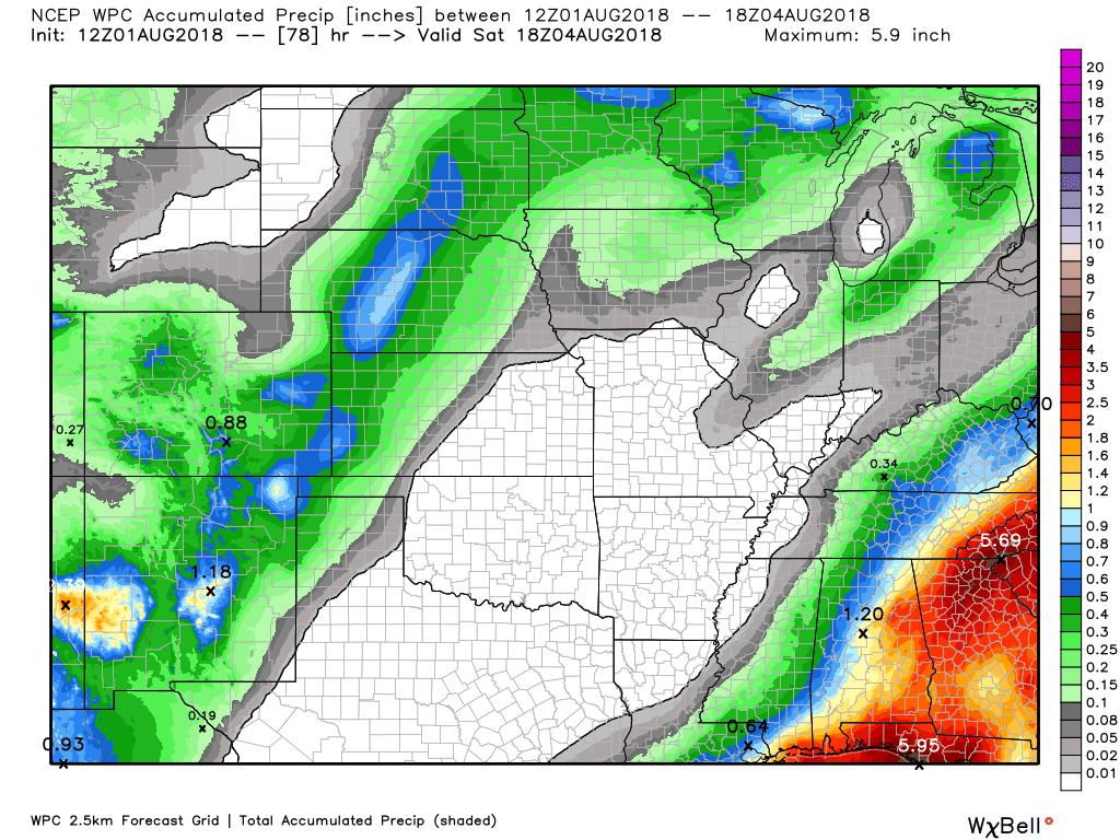
Here is the latest WPC / NOAA Rainfall charts
This rain would fall today into this evening.
This graphic will not cover those wild swings in rainfall totals that occur from locally heavy thunderstorms. These number will be greatly underdone where slow moving thunderstorms occur.
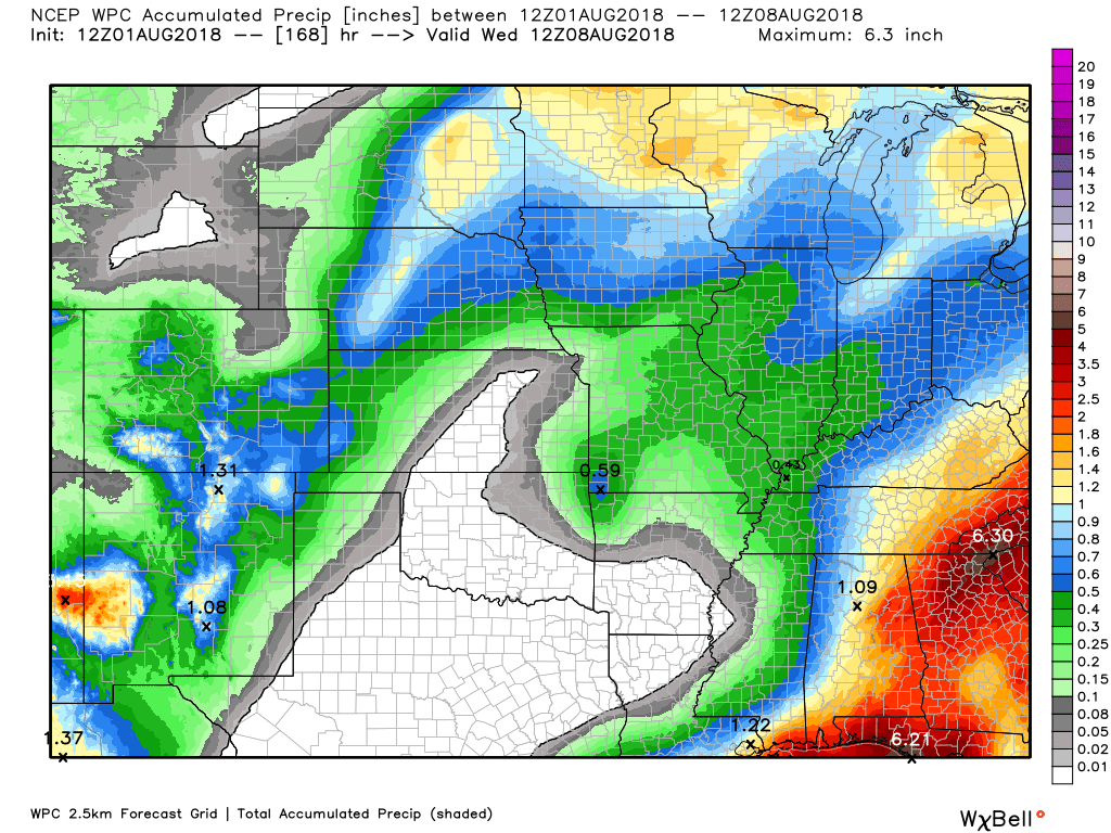
This graphic is from today into Saturday afternoon
This graphic is the seven day rainfall outlook.
.

We offer interactive local city live radars and regional radars. If a radar does not update then try another one.
If a radar does not appear to be refreshing then hit Ctrl F5 on your keyboard.
You may also try restarting your browser.
The local city view radars also have clickable warnings.
During the winter months, you can track snow and ice by clicking the winterize button on the local city view interactive radars.

Questions? Broken links? Other questions?
You may email me at beaudodson@usawx.com

The National Weather Service defines a severe thunderstorm as one that produces quarter size hail or larger, 58 mph winds or greater, and/or a tornado.
ind with height and/or the increase of wind speed with height. This is one ingredient when forecasting severe thunderstorms.
Today through Monday: The bulk of the region will avoid thunderstorms today into Sunday night.
A few isolated storms will be possible. This would mainly be during the heat of the day. The greatest chance would be across western Kentucky. In particular our eastern counties.
There will be some uptick in shower and thunderstorm activity Monday afternoon into Tuesday. Too early to know if severe weather is a concern.
Summer thunderstorms can produce isolated microbursts.
microburst winds can exceed 50 mph.
What are microbursts?

Interactive live weather radar page. Choose the city nearest your location. If one of the cities does not work then try a nearby one. Click here.
National map of weather watches and warnings. Click here.
Storm Prediction Center. Click here.
Weather Prediction Center. Click here.

Live lightning data: Click here.

Interactive GOES R satellite. Track clouds. Click here.

Here are the latest local river stage forecast numbers Click Here.
Here are the latest lake stage forecast numbers for Kentucky Lake and Lake Barkley Click Here.

The summer outlook have been posted for subscribers. Scroll down to see the outlook.Not a subscriber? Learn more at this link.

Weather Headlines
- Morning fog. Clouds today.
- Isolated shower or thunderstorm today over southeast Illinois and western Kentucky
- Mostly dry tonight into Sunday night (isolated heat of the day storms)
- Cold front Monday afternoon into Tuesday may produce some thunderstorms
Many of you picked up showers and thunderstorms Tuesday. Some did miss out. Most of the region received 0.25″ to 0.75″ of rain over the past seven days. A few areas picked up one to four inches of rain. Summer thunderstorms can produce a lot of rain.
There were several reports of cold air funnels Tuesday afternoon and evening. These often form when an upper level low passes over our region. Typically, they don’t touch down. Occasionally, one will.
We did have a waterspout on Kentucky Lake Tuesday evening, as well!
Calmer weather will prevail today into Sunday night.
I can’t rule out a shower or thunderstorm over southeast Illinois and western Kentucky today. Odds favor the bulk of the region remaining dry.
Temperatures will slowly increase as we move into the weekend. Some 90 degree readings will return Friday into Sunday. Dew points will also be on the rise. It will become muggier. Summer weather is not finished.
A cold front will nudge into the region Monday afternoon into Tuesday. This will be the focus of shower and thunderstorm chances early next week.
Storms Monday afternoon into Tuesday could produce locally heavy downpours. We will have plenty of moisture in the summer atmosphere. Typically, that is the way summer goes. Plenty of moisture that is just waiting for lift. The lift would be the cold front.
Some uncertainties about precipitation coverage. We have a few days to monitor. It could be another hit or miss type event. Again, typical for the summer months when it comes to weather.
The August forecast has been updated. Outlook definitions
Outlook definitions
EQ = Equal chances of above or below normal
BN= Below normal
M/BN = Much below normal
AN = Above normal
M/AN = Much above normal
E/AN = Extremely above normal.

These videos are for subscribers.
Subscribe at www.weathertalk.com

These videos are for subscribers.
Subscribe at www.weathertalk.com

These videos are for subscribers.
Subscribe at www.weathertalk.com

I bring these to you from the BAMwx team. They are excellent long-range forecasters.
Remember, long-range outlooks are a bit of skill, understanding weather patterns, and luck combined. It is not an exact science.

Normal high temperatures for this time of the year are around 92 degrees.
Normal low temperatures for this time of the year are around 69 degrees.
Normal precipitation during this time period ranges from 0.25″ to 0.50″
This outlook covers August 1st through August 6th
These graphics are for subscribers.
Subscribe at www.weathertalk.com
The precipitation forecast is PERCENT OF NORMAL. For example, if your normal rainfall is 1.00″ and the graphic shows 10%, then that would mean 0.10″ of rain is anticipated.
Always keep in mind, slow moving summer thunderstorms can produce torrential rain. That could skew the rainfall outlook.
These graphics are for subscribers.
Subscribe at www.weathertalk.com

These graphics are for subscribers.
The precipitation forecast is PERCENT OF NORMAL. For example, if your normal rainfall is 1.00″ and the graphic shows 10%, then that would mean 0.10″ of rain is anticipated.
These graphics are for subscribers.
Subscribe at www.weathertalk.com

These graphics are for subscribers.
Subscribe at www.weathertalk.com
And precipitation
These graphics are for subscribers.
Subscribe at www.weathertalk.com
Temperature outlook for June through August.
These graphics are for subscribers.
Subscribe at www.weathertalk.com
July temperature and precipitation outlook
These graphics are for subscribers.
Subscribe at www.weathertalk.com
August temperature and precipitation outlook
These graphics are for subscribers.
Subscribe at www.weathertalk.com
![]()

A new weather podcast is now available! Weather Geeks (which you might remember is on The Weather Channel each Sunday)
To learn more visit their website. Click here.
![]()

WeatherBrains Episode 652
Tonight’s Guest WeatherBrain is a weather legend, having spanned four decades as a broadcast meteorologist. He is a Fellow of the AMS. Joe Witte, welcome to WeatherBrains!
Other discussions in this weekly podcast include topics like:
- Athletes who are passionate about weather
- What all is involved with TV weather internships
- NASA’s intern program
- KATV’s Ned Perme retiring after 34 years
- Astronomy Outlook with Tony Rice
- Drake University sportscaster Larry Cotlar dies in Iowa flash flooding
- and more!
Link to web-site https://weatherbrains.com/
Previous episodes can be viewed by clicking here.
We offer interactive local city live radars and regional radars. If a radar does not update then try another one. If a radar does not appear to be refreshing then hit Ctrl F5. You may also try restarting your browser.
The local city view radars also have clickable warnings.
During the winter months, you can track snow and ice by clicking the winterize button on the local city view interactive radars.
You may email me at beaudodson@usawx.com
Find me on Facebook!

Find me on Twitter!

Did you know that a portion of your monthly subscription helps support local charity projects?
You can learn more about those projects by visiting the Shadow Angel Foundation website and the Beau Dodson News website.

I encourage subscribers to use the app vs regular text messaging. We have found text messaging to be delayed during severe weather. The app typically will receive the messages instantly. I recommend people have three to four methods of receiving their severe weather information.
Remember, my app and text alerts are hand typed and not computer generated. You are being given personal attention during significant weather events.
