We have some great sponsors for the Weather Talk Blog. Please let our sponsors know that you appreciate their support for the Weather Talk Blog.
Milner and Orr Funeral Home and Cremation Services located in Paducah, Kentucky and three other western Kentucky towns – at Milner and Orr they believe in families helping families. You can find Milner and Orr on Facebook, as well.
![]()
.

Wortham Dental Care located in Paducah, Kentucky. The gentle dentist. Mercury free dentistry. They also do safe Mercury removal. You can find Wortham Dental Care on Facebook, as well
.

Trover’s Equipment and Lawn Care – Family owned and operated! They are a dealer for Snapper, Simplicity, Snapper Pro, Bad Boy Mowers, and Intimidator Utility Vehicles. They are a Stihl and Dolmar power products dealer. They also are a dealer for Briggs & Stratton, Kohler gas & diesel engines, and Kawasaki engines. They service and repair just about any brand. You can find them on Facebook, as well
.

Visit their web-site here. Or, you can also visit their Facebook page.
.

Endrizzi’s Storm Shelters – For more information click here. Endrizzi Contracting and Landscaping can be found on Facebook, as well – click here
.
Are you looking for a full service insurance agency that writes homes, businesses, and vehicles in Illinois, Kentucky, and Tennessee. Call Gary’s office at 270.442.8234 for rates and plans to protect what matters to you!

Gary Eckelkamp’s web-site click the above banner or click here
.

This forecast update covers far southern Illinois, far southeast Missouri, and far western Kentucky. See the coverage map on the right side of the blog.
Remember that weather evolves. Check back frequently for updates, especially during active weather.
The forecast numbers below may vary a bit across the region. These are the averages.
WEATHER RADAR PAGE – Click here —
Friday night – Mostly clear sky conditions. Nice weather. Nice camping weather. Low humidity.
Temperatures: Lows in the 60’s
Winds: Light mainly northerly winds at 5 mph.
My confidence in this part of the forecast verifying is high
Should I cancel my outdoor plans? No
Is severe weather expected? No
What is the chance for precipitation? Not expecting rain
What impact is expected? Not expecting rain
Saturday – Some clouds in the morning. Then becoming mostly sunny. Some cumulus clouds possible in the afternoon. Pleasant. Less humid. Warm.
Temperatures: Highs in the 80’s.
Winds: Variable winds at 5 mph. North winds mainly. Occasional 10 mph gust.
My confidence in this part of the forecast verifying is high
Should I cancel my outdoor plans? No
Is severe weather expected? No
What is the chance for precipitation? Not expecting precipitation.
What impact is expected? None
Saturday night – Some patchy clouds. Cooler. Nice weather for summer! Pleasant. There is a hint on some models of a shower or two Saturday night. Let’s go with 10% and leave it alone for now.
Temperatures: Lows in the 60’s
Winds: Light northerly winds
My confidence in this part of the forecast verifying is high
Should I cancel my outdoor plans? No
Is severe weather expected? No
What is the chance for precipitation? 10%
What impact is expected? None
Sunday – A mix of sun and clouds. Warm. Not so humid. Perhaps some afternoon increase in clouds. Small chance for a shower or thunderstorm during the afternoon over southwest Illinois and southeast Missouri.
Temperatures: Highs in the 80’s. Perhaps touching 90 in a few spots.
Winds: Variable winds at 5-10 mph. Winds gusty in the afternoon at 10-15 mph.
My confidence in this part of the forecast verifying is high
Should I cancel my outdoor plans? No
Is severe weather expected? No
What is the chance for precipitation? 20% chance (will monitor)
What impact is expected? None
Sunday night – Some patchy clouds. Cooler. Nice weather for summer! Pleasant.
Temperatures: Lows in the 60’s
Winds: Southwest winds at 5-10 mph. Winds in the evening may gust above 20 mph.
My confidence in this part of the forecast verifying is high
Should I cancel my outdoor plans? No
Is severe weather expected? No
What is the chance for precipitation? 10%
What impact is expected? None
Monday – A mix of sun and clouds. Perhaps increasing clouds during the afternoon hours. Warm and a bit more humid. Dew points will be on the rise. That may mean it will feel a bit more stuffy outside.
Temperatures: Highs from 88 degrees to 92 degrees.
Winds: Southwest winds at 5-10 mph.
My confidence in this part of the forecast verifying is high
Should I cancel my outdoor plans? No
Is severe weather expected? No
What is the chance for precipitation? Not anticipating rain
What impact is expected? None

![]()
Sunrise and Sunset Times – Click Here


Don’t forget to check out the Southern Illinois Weather Observatory web-site for weather maps, tower cams, scanner feeds, radars, and much more! Click here

An explanation of what is happening in the atmosphere over the coming days…
Highlights
1. Some nice days ahead of us
2. Less humidity, but warm.
Well, I am enjoying this weather. What about you? I am not expecting any active* weather through the weekend.
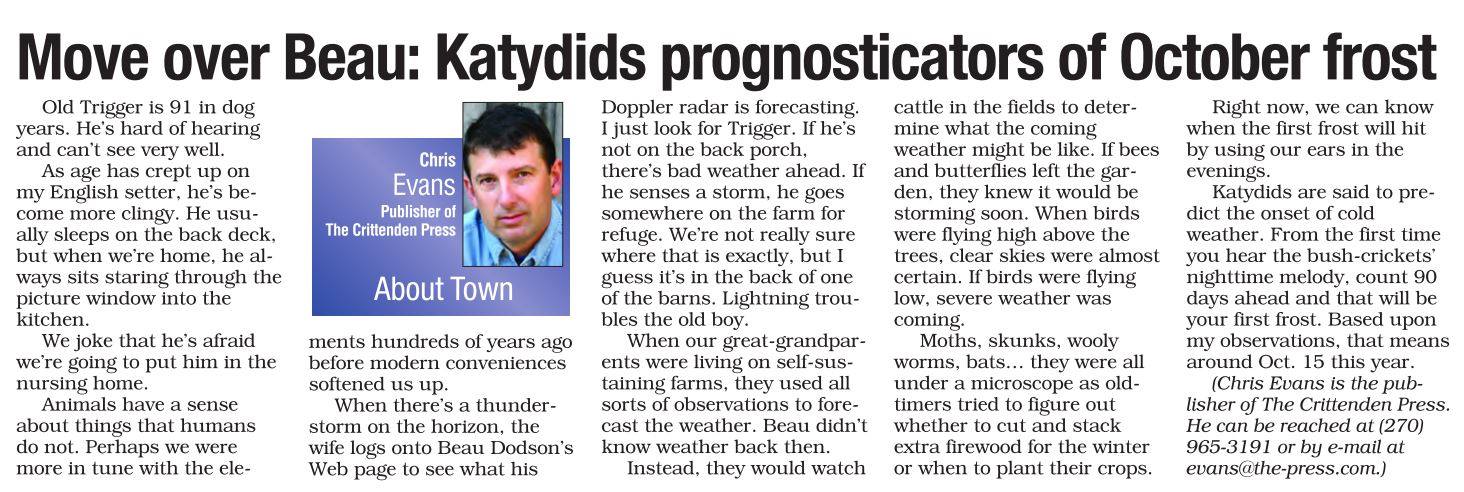
I suppose it is never too soon for the fall outlook? Chris Evans, Publisher of The Crittenden Press has thrown in the first outlook of the season. Well, I say Chris, but actually it was his dog Trigger (who is 91 years old and I admit does have some years on me) and the friendly bush-crickets aka Katydids. If we are to believe the Katydids then the first frost will be around October 15th. And, who am I to disagree with natures finest noise maker (and Trigger, as well). I did reach out to Chris to determine whether or not Trigger might be able to help me with the first snow and snow totals for the upcoming winter season (you see, that is where the money is). But, at this point it appears that Trigger is holding his cards (or doggie biscuits) close to his vest.
Here is the article. You will need to click the image to enlarge the size of the article.
Thanks, Chris. And, my offer stands. If Trigger is seeking employment (yes, I realize he is a retired weatherdog) then just let me know. I could always use a stand-in!
*I am watching a weak disturbance on Sunday for our far far northern counties. Small chances for some precipitation. I will keep an eye on it. Some data brings showers into southwest Illinois and southeast Missouri on Sunday. I am not just not convinced they will survive that far south. However, the EC has been adamant about this subject. Again, let’s check back on Saturday for an update.
Otherwise, enjoy your weekend weather. Low humidity and warm temperatures.

This section of the blog is speculative forecast information. Because it is past the range of what meteorologists can forecast accurately, it should be considered speculation. Anything past day 5 is considered a long range forecast.
Highlights
1. Cold front next Wednesday and Thursday
2. How did my July forecast turn out?
The next two weeks should bring more below normal temperatures than above normal temperatures. Several cold fronts to monitor.
Speaking of long range forecasts.
August. I am forecasting more below normal temperature days than above normal temperature days. I am forecasting near normal to slightly above normal precipitation. As always, precipitation will likely vary greatly. Thunderstorms can drop a LOT of rain in localized areas.
How did July turn out?
Well, it was mixed. I predicted above normal precipitation for the Missouri and Ohio Valleys. And below normal temperatures for the Missouri and Ohio Valleys.
We certainly did have the above normal precipitation! But, temperatures were mixed.
Here is the temperature map. Most of the Missouri and Ohio Valleys ended up blue. That means below normal temperatures. Our region ended up right on the line between below and above normal temperatures. It was a tough call, which I knew it would be. The ridge to our south kept intruding.
The overnight lows were higher than expected because of all the moisture in the ground. Something I did not account for (doh).
I always say that perception is all that matters when it comes to weather. The perception was that July was hot. Even though Paducah only reached 95 degrees twice during the entire month. No 100 degree readings were recorded.

Let’s look at the official temperature obs from Paducah, Kentucky. Everything in light blue was at or below normal in the temperature department. Those are days that were at or below normal. We would have experienced a few more, but all the moisture in the ground kept overnight lows warmer than they usually would have been. This skewed the data.
That means 15’ish days of the month were at or below normal in the temperature department. About split!

Many locations picked up 5″-10″+ of rain. These are incredible numbers for the Month of July. It is summer gosh darnnit.
Here are the rainfall maps for July. You can barely see the state outlines. Again, this is an incredible amount of rain. Click image for a larger view of this weatherbell.com map
Scale is on the right.

Zooming in on our region. I did add Paducah to help you find your way around the map. Hard to see the state outlines.

Let’s look at the percent of normal precipitation map. This is for precipitation. Some places were 200-350% above normal.

Looking ahead to the new work week…
The GFS model has decided to blow up a storm over our region on Monday and Tuesday. I am skeptical of what it is showing. It takes a deep low through Missouri. The model has little or no other support from its peers. So, this means I will keep 1/2 eye on the other models. The GFS model has been horrible this summer. They supposedly fixed it, but I think they broke it. lol
A stronger cold front will dive into the region towards the middle of next week. This front will trigger some showers and thunderstorms. Not sure if we will have to deal with locally heavy rain. But, I will be monitoring.
Cooler air will find itself reinforced behind this front. But, how cool? Some data shows cooler than other data.
Best chances for rain and storms might end up on Wednesday. Some data brings precipitation into the region as soon as Tuesday night.
Tough call on rainfall totals. A large MCS is likely to move to our north with this front. That will drop several inches of rain. But, whether our region ends up in an MCS will need to be determined. Remember, an MCS is a large thunderstorm complex. Similar to the ones we have been dealing with the last few months. They can drop a lot of rain in a short amount of time.
Radars
WEATHER RADAR PAGE – Click here —

I also set up a storm tracking page with additional links (use during active weather for quick reference)
Storm Tracking Tool Page
Don’t forget to support our sponsors!

How much precipitation should we expect over the next few days?
Precipitation is not expected to be an issue through at least Sunday, for most of the area.
I am watching a weak system on Sunday for mainly north of our region. However, some of the models paint a bit of precipitation perhaps towards I64. I will continue to monitor and update accordingly.

Can we expect severe thunderstorms over the next 24 to 48 hours? Remember that a severe thunderstorm is defined as a thunderstorm that produces 58 mph winds or higher, quarter size hail or larger, and/or a tornado.
Thunderstorm threat level is ZERO.
Friday – Sunday: Not expecting severe weather
Monday: No severe weather anticipated.
Tuesday: No severe weather anticipated.
Wednesday: Thunderstorms are possible. Too soon to determine whether severe weather will be a concern.


No significant concerns through the weekend.

Here are the current river stage forecasts. You can click your state and then the dot for your location. It will bring up the full forecast and hydrograph.
Click Here For River Stage Forecasts…
Here are some current forecast hydrographs. These will be updated each day with new information.


Smithland Lock and Dam

Paducah, Kentucky Forecast Stage

Cairo, Illinois

Cape Girardeau, Missouri
Current Temperatures Around The Local Area


We have regional radars and local city radars – if a radar does not seem to be updating then try another one. Occasional browsers need their cache cleared. You may also try restarting your browser. That usually fixes the problem. Occasionally we do have a radar go down. That is why I have duplicates. Thus, if one fails then try another one.
If you have any problems then please send me an email beaudodson@usawx.com
WEATHER RADAR PAGE – Click here —
We also have a new national interactive radar – you can view that radar by clicking here.
Local interactive city radars include St Louis, Mt Vernon, Evansville, Poplar Bluff, Cape Girardeau, Marion, Paducah, Hopkinsville, Memphis, Nashville, Dyersburg, and all of eastern Kentucky – these are interactive radars. Local city radars – click here
NOTE: Occasionally you will see ground clutter on the radar (these are false echoes). Normally they show up close to the radar sites – including Paducah.

Regional Radar – Click on radar to take you our full radar page.


Regional Radar

Live Lightning Data – zoom and pan: Click here
Live Lightning Data with sound (click the sound button on the left side of the page): Click here
I also set up a storm tracking page with additional links (use during active weather for quick reference)
Storm Tracking Tool Page
![]()
Current WARNINGS (a warning means take action now). Click on your county to drill down to the latest warning information. Keep in mind that there can be a 2-3 minute delay in the updated warning information.
I strongly encourage you to use a NOAA Weather Radio or warning cell phone app for the most up to date warning information. Nothing is faster than a NOAA weather radio.


Color shaded counties are under some type of watch, warning, advisory, or special weather statement. Click your county to view the latest information.

Missouri Warnings

Illinois Warnings

Kentucky Warnings

Here is the official 6-10 day and 8-14 day temperature and precipitation outlook. Check the date stamp at the top of each image (so you understand the time frame).
The forecast maps below are issued by the Weather Prediction Center (NOAA).


The latest 8-14 day temperature and precipitation outlook. Note the dates are at the top of the image. These maps DO NOT tell you how high or low temperatures or precipitation will be. They simply give you the probability as to whether temperatures or precipitation will be above or below normal.


Who do you trust for your weather information and who holds them accountable?
I have studied weather in our region since the late 1970’s. I have 37 years of experience in observing our regions weather patterns. My degree is in Broadcast Meteorology from Mississippi State University and an Associate of Science (AS). I am currently working on my Bachelor’s Degree in Geoscience. Just need to finish two Spanish classes!
I am a member of the American Meteorological Society. I am a NOAA Weather-Ready Nation Ambassador. And, I am the Meteorologist for McCracken County Emergency Management.
I own and operate the Southern Illinois Weather Observatory.
There is a lot of noise on the internet. A lot of weather maps are posted without explanation. Over time you should learn who to trust for your weather information.
My forecast philosophy is simple and straight forward.
- Communicate in simple terms
- To be as accurate as possible within a reasonable time frame before an event
- Interact with you on Twitter, Facebook, and the blog
- Minimize the “hype” that you might see on television or through other weather sources
- Push you towards utilizing wall-to-wall LOCAL TV coverage during severe weather events
I am a recipient of the Mark Trail Award, WPSD Six Who Make A Difference Award, Kentucky Colonel, and the Caesar J. Fiamma” Award from the American Red Cross. In 2009 I was presented with the Kentucky Office of Highway Safety Award. I was recognized by the Kentucky House of Representatives for my service to the State of Kentucky leading up to several winter storms and severe weather outbreaks.
If you click on the image below you can read the Kentucky House of Representatives Resolution.

I am also President of the Shadow Angel Foundation which serves portions of western Kentucky and southern Illinois.
Many of my graphics are from www.weatherbell.com – a great resource for weather data, model data, and more


You can sign up for my AWARE email by clicking here I typically send out AWARE emails before severe weather, winter storms, or other active weather situations. I do not email watches or warnings. The emails are a basic “heads up” concerning incoming weather conditions.