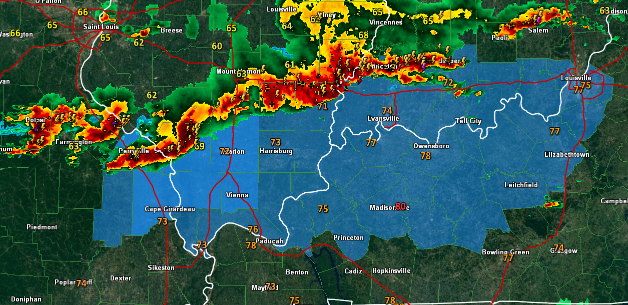
3:30 PM
Storms are lined up from southeast Missouri into northwest Kentucky. Occasionally one of the storms pulses up to severe levels.
Monitor radars if you have concerns
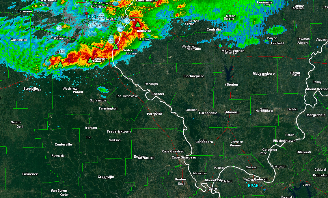
2 PM
Storms are lined up from SE Missouri into southern Illinois and then into southern Indiana. A new severe thunderstorm watch covers more of Kentucky and Indiana.
Storms are moving east/southeast and sagging southward. High winds possible with some storms.
Very heavy rainfall where storms are moving over the same areas repeatedly.
Monitor watches and warnings – links below (and radars)
Dozens of storm tracking tools
http://weathertalk.com/storm-tracking-tools/
Here is the 2 pm radar view of the line of storms (blue area is the severe thunderstorm watch)
11:40 AM
Storms are moving more east than southeast now. At this time they are reorganizing. We will have to see if they get back into the severe category with large hail and damaging winds. Monitor radars if you have concerns. Mostly southern Illinois, at this time.
10:45 AM
Updated graphic
10:30 AM
Line of strong to occasionally severe thunderstorms is pushing out of east central Missouri into southern Illinois. It is moving east/southeast. A little bit south, as well.
Radar shows it nicely
The Paducah, KY NWS Office issued this statement concerning the line of storms.

...SEVERE THUNDERSTORM WATCH REMAINS IN EFFECT UNTIL 2 PM CDT FOR
A SMALL PART OF SOUTHWEST ILLINOIS AND SOUTHEAST MISSOURI...

STRONG TO SEVERE THUNDERSTORMS CONTINUE DEVELOP AND MOVE ACROSS
THE SAINT LOUIS METROPOLITAN AREA THIS MORNING. THESE STORMS HAVE
HAD A HISTORY OF PRODUCING HAIL FROM ONE QUARTER TO NEAR TWO AND A
QUARTER INCHES IN SIZE AS THEY MOVED ACROSS EAST CENTRAL MISSOURI.
SOME REPORTS OF WIND DAMAGE WERE REPORTED AS WELL.

THE STORMS HAVE BEEN MOVING EAST...SOUTHEAST BETWEEN 20 AND 25
MPH. SHOULD THE STORMS CONTINUE TO MOVE AT THIS SPEED...THEY WILL
REACH PARTS OF NORTHWEST PERRY COUNTY ILLINOIS...EAST OF
COULTERVILLE ILLINOIS BETWEEN 1215 PM AND 1230 PM CDT AND NEAR
SAINT MARY IN NORTHWEST PERRY COUNTY MISSOURI BEFORE 1 PM CDT.

THERE ARE INDICATIONS THAT THE STORMS OVER THE SAINT LOUIS AREA
MAY MOVE MORE TO THE SOUTHEAST ALONG THE MISSISSIPPI
RIVER...IMPACTING PARTS OF SOUTHEAST MISSOURI AND SOUTHWEST
ILLINOIS AROUND MIDDAY.

STAY TUNED TO NOAA WEATHER RADIO...COMMERICAL TELEVISION AND
RADIO...AS WELL AS INTERNET FOR ADDITIONAL
INFORMATION...FORECASTS...STATEMENTS AND POSSIBLE WARNINGS.
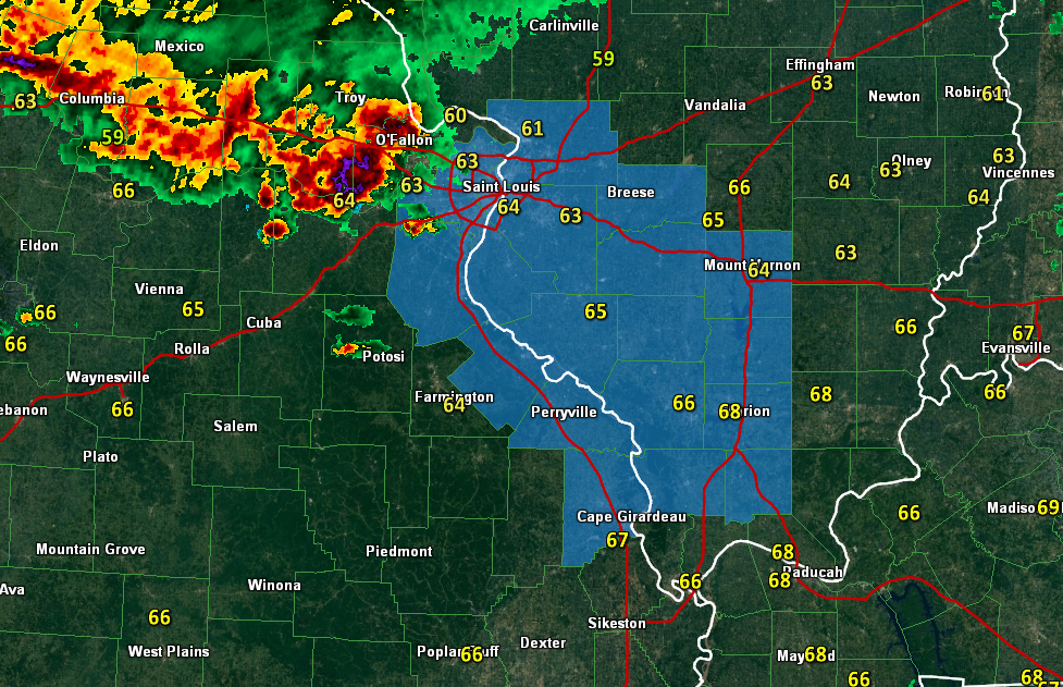
8:30 AM
A severe thunderstorm watch has been issued for the area in blue on this graphic – storms are moving out of the St Louis area and are moving south/southeast. That means the area of concern will include parts of eastern Missouri and southern Illinois.
8 AM Update
Overnight storms produced heavy rain and intense lightning over the area. A few reports of small hail, as well.
Those storms have moved off to the east.
A new complex of storms is moving through the St Louis area with high winds and hail. This complex of storms is moving southeast.
If it holds together then it will move into southern Illinois over the coming hours. A few of the storms could produce high winds and hail.
I have updated the graphic below to reflect this.
This graphic is mainly for eastern Missouri into southern Illinois. Check back for updates. If the storms hold together then they could move into west Kentucky, as well.
We have some great sponsors for the Weather Talk Blog. Please support them when you have the opportunity.
Milner and Orr Funeral Home and Cremation Services located in Paducah, Kentucky and three other western Kentucky towns – at Milner and Orr they believe in families helping families. You can find Milner and Orr on Facebook, as well.
![]()

This forecast update covers far southern Illinois, far southeast Missouri, and far western Kentucky. See the coverage map on the right side of the blog.
Remember that weather evolves. Check back frequently for updates, especially during active weather.
The forecast numbers below may vary quite a bit across the region. These are averages.
Tonight – Some thunderstorms redeveloping late tonight – especially over southeast Illinois, southwest Indiana, and parts of northwestern Kentucky. Other areas will need to be monitored, as well. Some of these storms could produce hail. Another area of concern extends from northern Missouri into east central Missouri. I have lower confidence on how tonight unfolds. These overnight hail events can be tricky to forecast. Hopefully some storms pop but without the hail.
Tuesday – Some early morning heavy thunderstorms for portions of the region. Gusty winds and hail. Storms should be moving out by sunrise or a bit after. Remainder of the day…a chance for a scattered thunderstorm. Very warm. Highs well into the 70’s and perhaps touching 80 in some areas. Southerly winds at 10-20 mph. My confidence in this part of the forecast verifying is high.
Should I cancel my outdoor plans? Could be some scattered storms around. Most of the day should end up dry for many areas. I would monitor radars if I had an outdoor activity planned. Outdoor sports should monitor lightning data.
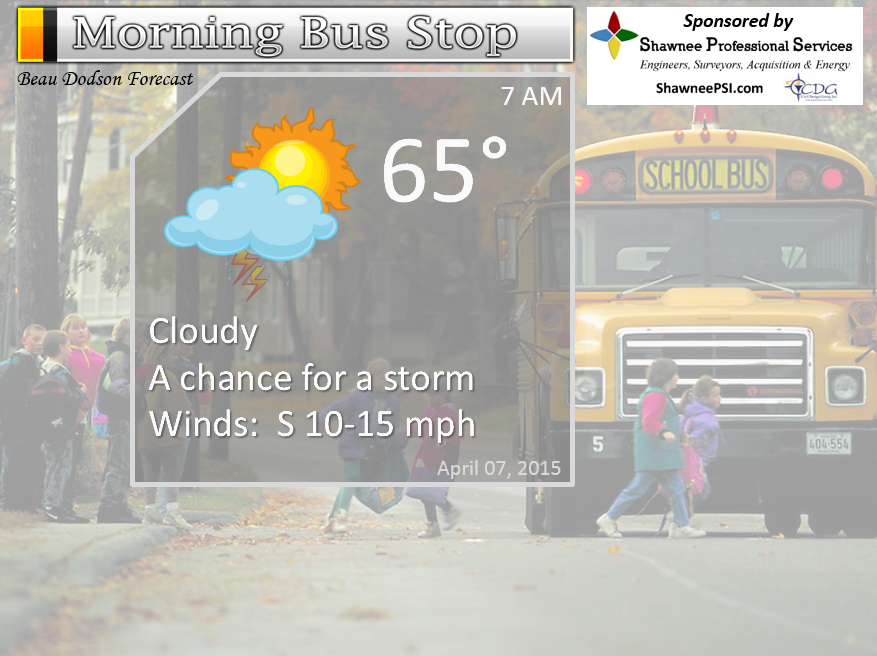
Morning School Bus Stop Weather – Cloudy during the morning with a few scattered showers or storms around. Mild. Temperatures in the 60’s. South winds 10-15 mph
—————————————————————————————-
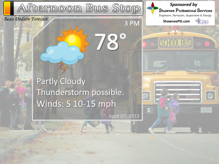
Afternoon School Bus Stop Weather – Partly sunny and warm. Humid. Highs in the 70’s. Stray thunderstorm possible. South winds 10-15 mph. Gusts to 20 mph.
Tuesday night – Partly cloudy. A thunderstorm possible. Mild. Lows only in the 60’s. South winds at 10-15 mph with gusts to 20 mph. My confidence in this part of the forecast verifying is high
Should I cancel my outdoor plans? You should be okay. Monitor radars for a few stray storms.
Wednesday – Partly sunny and warm. A scattered thunderstorm possible. Storms may increase from west to east late in the afternoon. Some storms could be heavy. Mild. Highs well into the 60’s. South winds at 10-15 mph. Gusty at times. My confidence in this part of the forecast verifying is high.
Should I cancel my outdoor plans? You should be okay. Monitor radars for a few stray storms.
Wednesday night – Cloudy. A chance for thunderstorms. Locally heavy rain with any storms that do form. Lows in the 60’s. South/southwest winds at 10-15 mph. Gusts to 20 mph. My confidence in this part of the forecast verifying is high.
Should I cancel my outdoor plans? Monitor radars. Some overnight storms are possible.
Thursday – Partly sunny. Mild. Windy at times. An increasing chance for heavy thunderstorms during the afternoon and overnight hours. Some storms could become severe. South/southwest winds at 10-25 mph with gusts above 25 mph. My confidence in this part of the forecast verifying is medium.
Should I cancel my outdoor plans? Have a plan B in case storms move into the area.

The School Bus Stop Forecast is brought to your by Shawnee Professional Services. For more information click here
Current Temperatures Around The Local Area


Don’t forget to check out the Southern Illinois Weather Observatory web-site for weather maps, tower cams, scanner feeds, radars, and much more! Click here

An explanation of what is happening in the atmosphere over the coming days…
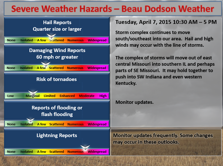
Highlights
1. Early morning Tuesday boomers. A few could produce hail (low confidence on hailers tonight).
2. Unsettled weather into Friday
3. A round of heavy storms possible Wednesday evening into Wednesday night.
4. Regional severe weather risk Thursday/Friday. Monitor updates closely
5. Dry for Saturday
6. Another weather event Sunday night into Monday? Additional heavy weather possible.
Some of you picked up heavy downpours on Monday morning into the afternoon hours. Lightning, heavy downpours, and 20-30 mph winds were about the extent of the morning thunderstorms. No reports of severe weather (nor was any expected).
We have an active week of weather ahead of us. Some of the weather could become severe. You will want to monitor updates each day. We will be in a fast changing weather pattern over the coming days.
I will try to break all of this down for each day. The biggest severe weather concerns are likely going to be on Thursday afternoon into Thursday night. Although, Wednesday evening will need to be closely monitored, as well.
Let’s break it down.
Early Tuesday morning outlook…
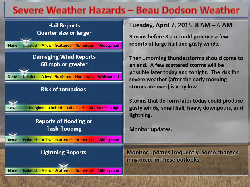
This is the severe weather outlook from midnight tonight until 8 am Tuesday morning. I will post a graphic like this each day (and update them if necessary)
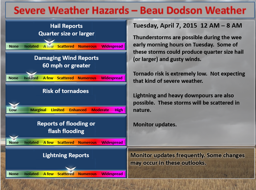
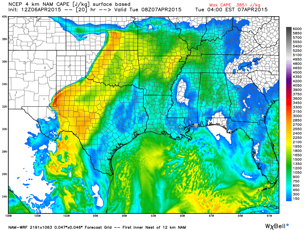
We will have another round of storms during the early morning hours of Tuesday. As of this writing, the timing is expected to be midnight through about 6 or 7 am Tuesday morning. Some of these storms could produce hail and high winds. Quarter size hail or larger can’t be ruled out with some of the thunderstorms. Thankfully the higher end severe weather risk is minimal (winds above 60 mph or tornadoes).
CAPE values actually rise through tonight (Monday night/Tuesday morning). You can see those numbers here. CAPE is a measure of energy available to thunderstorms to feed on. Higher the CAPE numbers the more intense storms can become. For more information on CAPE – click here. Image is from weatherbell.com
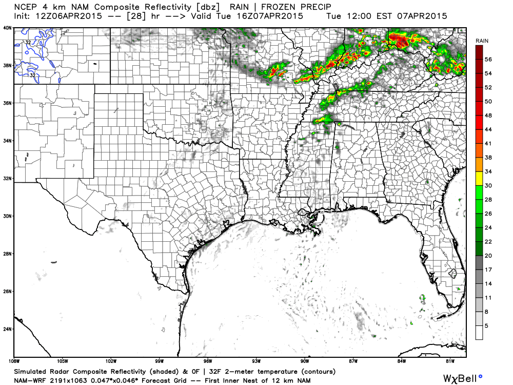
Here is the future-cast radar for late tonight (around 2 am or so). You can see a few storms dotting our region.
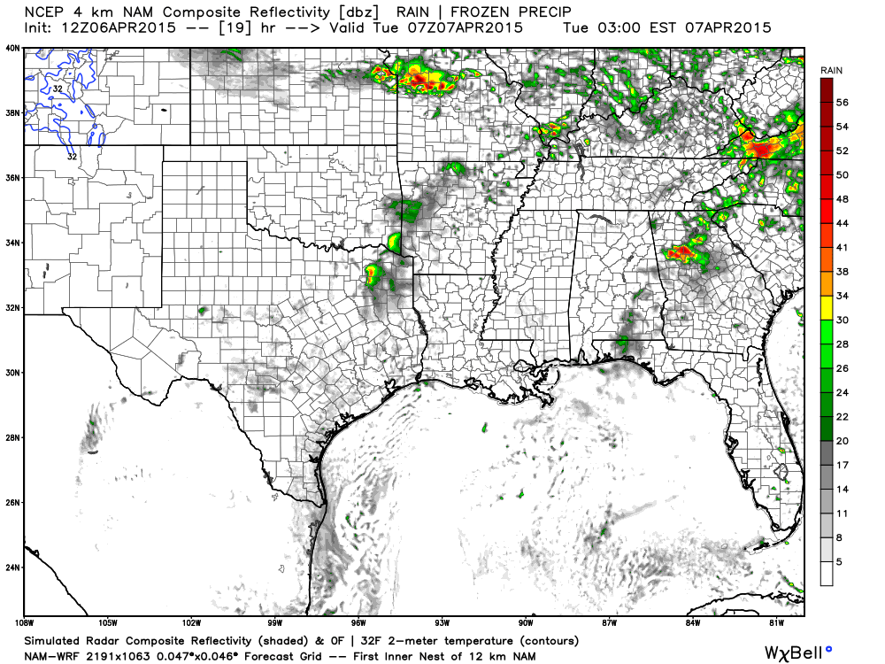
Then around 3 am to 5 am – you can see the heaviest storms are likely going to be over our northeast counties.
That would include parts of SE IL, SW IN, and NW KY. Another area of concern will be northern and central Missouri into east central Missouri.
The rest of the area could experience thunderstorms, as well. Hail possible.
Bottom line – a few storms tonight could produce some reports of hail. High winds are not likely and tornadoes are not in the forecast. Mainly lightning, heavy downpours, and some hail. Mostly northern half of the region (if they occur). Lower confidence on how this unfolds tonight.
Note another band of storms moving into Missouri. These could spread into our region on Tuesday during the day.
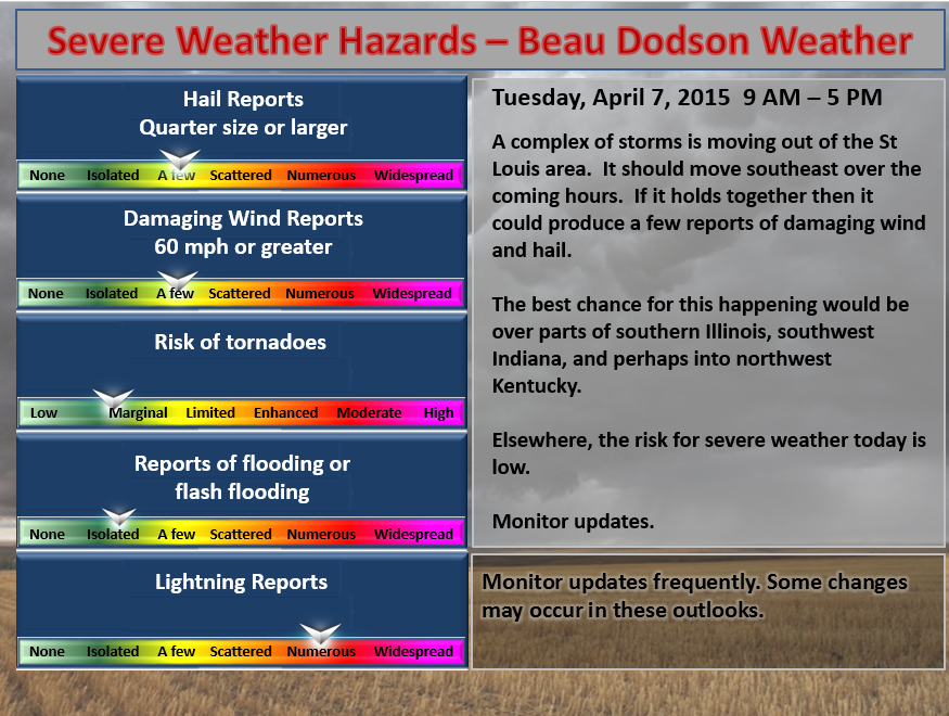
Tuesday late morning and afternoon outlook…
Note this outlook below is after the early morning Tuesday storms. The storms between midnight tonight and 8 am could produce a few reports of large hail (see the outlook above). This outlook below is for the rest of Tuesday into Tuesday night.
An unsettled few days ahead of us. We will remain in the warm sector of an approaching storm system. That means a few scattered thunderstorms possible on Tuesday afternoon into Wednesday afternoon.
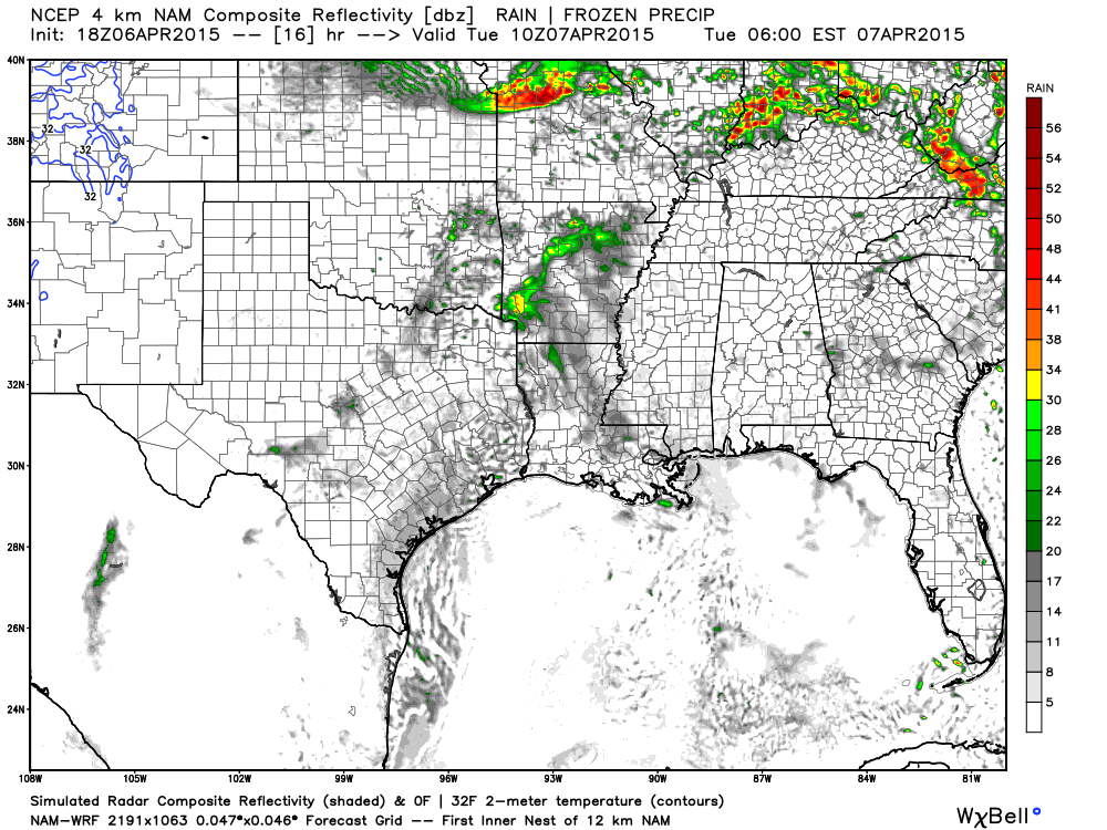
Future-cast radar for late Tuesday morning and afternoon even shows a band of thunderstorms approaching from the west/northwest. We will see if that happens.
Wednesday into Wednesday night outlook…
A stronger disturbance will push through the area on Wednesday evening and night. This will spark showers and locally heavy thunderstorms. Once again we might see a few reports of hail and gusty winds. Tornado risk on Wednesday night is low. Heavy rain is a concern. We don’t need additional heavy rain. Lightning, as always, will accompany the storms.
Check out the CAPE numbers for Wednesday afternoon and evening. This is concerning. If the WRF model is correct then I can’t rule out severe weather on Wednesday evening. These are very high CAPE numbers.
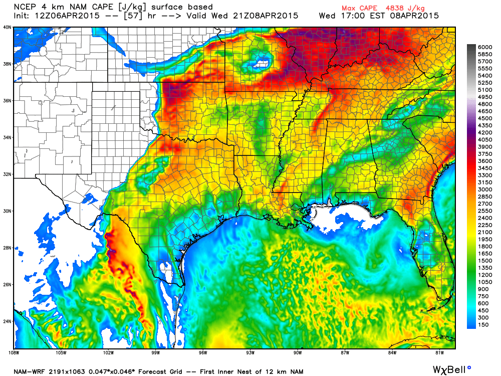
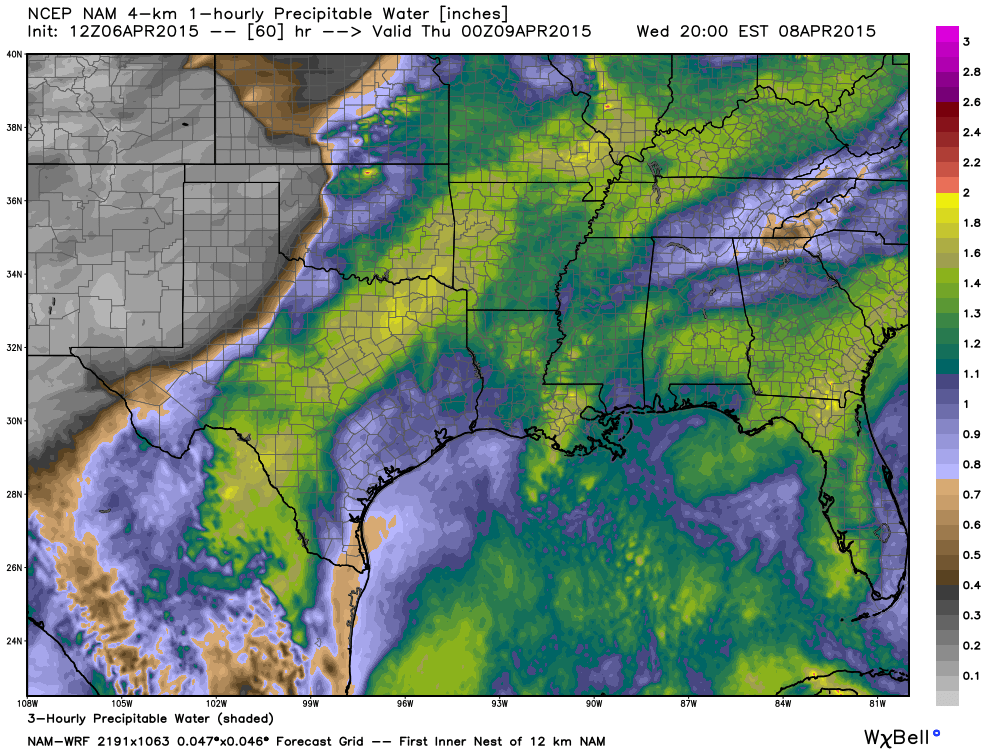
In addition to high CAPE numbers we will have high PWAT numbers. That means heavy rain will occur (if that complex of storms does move into our area). What are PWAT values? For you weather enthusiasts who really want to learn 🙂 – click here – I found that blog posting which sums it up nicely.
These numbers below are ahead of the Wednesday complex of storms. Again, let’s assume the WRF model is correct in the timing and placement of that complex. It will be running into some very high PWAT values. Extremely heavy downpours would be possible.
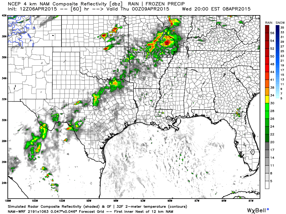
Future-cast radar from weatherbell.com – this is for Wednesday evening. You can see an area of storms moving towards our region from southern Missouri. We will have to keep an eye on this. Could be some heavy storms with this complex. The complex will move east and maybe a bit northeast.
Still some uncertainty on the exact placement and timing of this complex. Again, monitor updates because this is an unsettled pattern with a lot of fast moving parts.
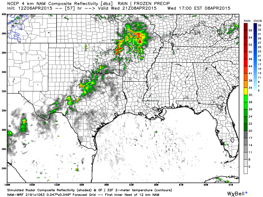
Then later on Wednesday evening – storms moving into our region. A few storms could be on the heavy side. Will need to monitor for the potential of some of these storms becoming severe.
Thursday and Friday outlook…
A larger severe weather event is possible on Thursday afternoon into Friday morning. An approaching cold front will be the trigger. Wind fields aloft will increase quite a bit on Thursday into Friday morning. CAPE levels will also be on the rise. Dew points well into the 60’s are likely for the region. These are all ingredients for severe thunderstorms.
There will be a risk for large hail, damaging winds, heavy rain, frequent lightning, and possibly tornadoes on Thursday afternoon into Friday morning. I will need to work on the timing of the squall line and possible supercells, as we move forward.
I recommend everyone monitor future updates on the upcoming busy week of weather.
Another storm system will approach our region on Sunday night into Monday night of next week. See discussion in the extended part of the blog.
Radars
WEATHER RADAR PAGE – Click here —
I also set up a storm tracking page with additional links (use during active weather for quick reference)
Storm Tracking Tool Page
Have you ever attended the Charleston, Missouri Dogwood Azalea Festival? This years festival will be April 16th through the 19th. Click here for more information

Don’t forget to support our sponsors!

Adjusted wind speeds. No other significant changes to the ongoing forecast.

Concerns early Tuesday morning about a few storms producing hail. Mainly this would be over SE IL, SW IN, and NW KY.
Otherwise, scattered storms between now and Thursday with brief heavy downpours and lighting.
One complex of storms will likely push into the region on Wednesday evening and night. This complex could produce some reports of severe weather. Monitor updates.
I am more concerned about Thursday afternoon into Friday for severe thunderstorms. All modes of severe weather may occur in and near our region. Monitor updates.
Check out our sponsors! There are more on the right side bar of the page, as well. Be sure and let them know that you appreciate their sponsorship of the WeatherTalk daily weather bulletin.
How about a $5 meal deal? The DQ Grill and Chill (located across from Noble Park in Paducah, Kentucky) is the newest WeatherTalk Blog sponsor! A local business helping to sponsor the weather information that you have come to love so much.
Check out their Facebook page for specials, as well DQ Grill and Chill on Facebook


Premier Portable Buildings proudly serving our region. For more information click the above ad or here
They can also be found on this Facebook page
G&C Multi-Services out of Paducah, Kentucky. G & C Multi-Services is a service provider in Western Kentucky that provides industrial and commercial equipment fabrication, machine troubleshooting, repair and maintenance, and installation. They can custom fabricate steel, stainless, and aluminum products per customer specifications.
Visit their web-site here. Or click the ad below! Facebook page.


Wortham Dental Care located in Paducah, Kentucky. The gentle dentist. Mercury free dentistry. They also do safe Mercury removal. You can find Wortham Dental Care on Facebook, as well

Trover’s Equipment and Lawn Care – Family owned and operated! They are a dealer for Snapper, Simplicity, Snapper Pro, Bad Boy Mowers, and Intimidator Utility Vehicles. They are a Stihl and Dolmar power products dealer. They also are a dealer for Briggs & Stratton, Kohler gas & diesel engines, and Kawasaki engines. They service and repair just about any brand. You can find them on Facebook, as well

Visit their web-site here. Or, you can also visit their Facebook page.

Endrizzi’s Storm Shelters – For more information click here. Endrizzi Contracting and Landscaping can be found on Facebook, as well – click here
The School Bus Stop Forecast is brought to your by Shawnee Professional Services. For more information click here

Shawnee Professional Services & Civil Design Group have been providing Land Surveying, Engineering, Grant Administration and Acquisition services for the past 20 years. Currently Licensed in Illinois, Kentucky, Missouri, Indiana, and Tennessee; please contact Shawnee for any Land Surveying or Engineering needs. Shawnee’s company size allows them to devote individual attention to each client and to approach each project with the required thoroughness to successfully complete the project, large or small. Visit Shawnee’s website at shawneepsi.com for more information. Shawnee has offices in Paducah, KY, Vienna, IL and Benton, Illinois.
.

Gary Eckelkamp’s web-site click the above banner or click here
.

Here are the current river stage forecasts. You can click your state and then the dot for your location. It will bring up the full forecast and hydrograph.
Rivers are on the rise. Additional heavy rain later this week won’t help our cause.
Click Here For River Stage Forecasts…
Here are some current forecast hydrographs. These will be updated each day with new information.


Smithland Lock and Dam

Paducah, Kentucky Forecast Stage

Cairo, Illinois

Monitor updated forecasts over the coming days. Severe weather will be possible, especially Thursday afternoon into Friday. Locally heavy rain, as well.
Umbrellas may be necessary from time to time.

The wild card tells you where the uncertainties are in the forecast
Wild card in this forecast – Whether or not we experience some reports of hail late Monday night and Tuesday morning. Otherwise, the wild card will be rainfall totals between now and Thursday morning. The scattered nature of the storms will likely mean a wide variety of rainfall totals.

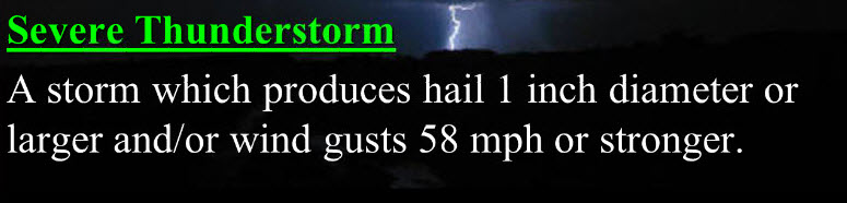
Can we expect severe thunderstorms over the next 24 to 48 hours? Remember that a severe thunderstorm is defined as a thunderstorm that produces 58 mph winds or higher, quarter size hail or larger, and/or a tornado.
Thunderstorm threat level is ONE/TWO (for Monday night into Tuesday morning) A few storms over the coming 24 hours could produce hail and gusty winds. Overall, after the early morning storms come to an end, the risk for severe weather is low (for Tuesday afternoon and Tuesday night).
Wednesday Severe Weather Outlook – Some severe weather possible on Wednesday evening and night.
.
Thursday Severe Weather Outlook – Severe thunderstorms are likely during the afternoon or overnight hours. Closely monitor updated forecasts.
.
Friday Severe Weather Outlook – Severe storms are possible until the cold front moves through the area.
.
Saturday Severe Weather Outlook – No severe weather anticipated.
.
Sunday Severe Weather Outlook – Monitor updates for the Sunday night time-frame.
Monday Severe Weather Outlook – Severe storms are possible. Monitor updates.


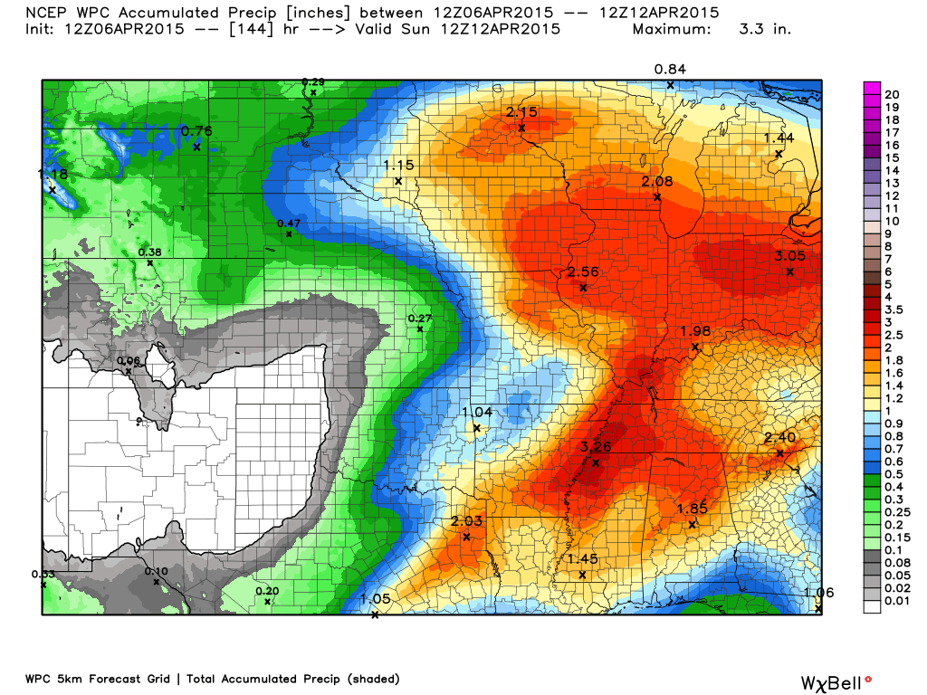
How much precipitation should we expect over the next few days?
Locally heavy rain will occur with thunderstorms that form over the coming days. The good news is that not everyone will get in on the action each day. Different portions of the area will experience storms.
The most widespread thunderstorm event is forecast to occur on Thursday afternoon into Friday. This is when the main cold front will push through the area. Very heavy downpours will occur along the front.

This section of the blog is speculative forecast information. Because it is past the range of what meteorologists can forecast accurately, it should be considered speculation. Anything past day 5 is considered a long range forecast.
Our next storm system is already starting to show up in the data for late Sunday and Monday. This one could also produce heavy weather. We will need to monitor it closely. It seems we have to monitor most storm systems closely! Especially true during the spring months.
An area of low pressure is forecast to move out of the Central United States on Sunday night and Monday. This system could produce locally heavy rain and perhaps severe weather. We don’t need either.
Monitor updates as we move forward. Busy time for meteorologists and storm trackers.

We have regional radars and local city radars – if a radar does not seem to be updating then try another one. Occasional browsers need their cache cleared. You may also try restarting your browser. That usually fixes the problem. Occasionally we do have a radar go down. That is why I have duplicates. Thus, if one fails then try another one.
If you have any problems then please send me an email beaudodson@usawx.com
WEATHER RADAR PAGE – Click here —
We also have a new national interactive radar – you can view that radar by clicking here.
Local interactive city radars include St Louis, Mt Vernon, Evansville, Poplar Bluff, Cape Girardeau, Marion, Paducah, Hopkinsville, Memphis, Nashville, Dyersburg, and all of eastern Kentucky – these are interactive radars. Local city radars – click here
NOTE: Occasionally you will see ground clutter on the radar (these are false echoes). Normally they show up close to the radar sites – including Paducah.

Regional Radar – Click on radar to take you our full radar page.


Regional Radar

Live Lightning Data – zoom and pan: Click here
Live Lightning Data with sound (click the sound button on the left side of the page): Click here

For the most up to date maps – click here


![]()
Current WARNINGS (a warning means take action now). Click on your county to drill down to the latest warning information. Keep in mind that there can be a 2-3 minute delay in the updated warning information.
I strongly encourage you to use a NOAA Weather Radio or warning cell phone app for the most up to date warning information. Nothing is faster than a NOAA weather radio.


Color shaded counties are under some type of watch, warning, advisory, or special weather statement. Click your county to view the latest information.

Missouri Warnings

Illinois Warnings

Kentucky Warnings

Here is the official 6-10 day and 8-14 day temperature and precipitation outlook. Check the date stamp at the top of each image (so you understand the time frame).
The forecast maps below are issued by the Weather Prediction Center (NOAA).


The latest 8-14 day temperature and precipitation outlook. Note the dates are at the top of the image. These maps DO NOT tell you how high or low temperatures or precipitation will be. They simply give you the probability as to whether temperatures or precipitation will be above or below normal.


Who do you trust for your weather information and who holds them accountable?
I have studied weather in our region since the late 1970’s. I have 37 years of experience in observing our regions weather patterns. My degree is in Broadcast Meteorology from Mississippi State University and an Associate of Science (AS). I am currently working on my Bachelor’s Degree in Geoscience. Just need to finish two Spanish classes!
I am a member of the American Meteorological Society. I am a NOAA Weather-Ready Nation Ambassador. And, I am the Meteorologist for McCracken County Emergency Management.
I own and operate the Southern Illinois Weather Observatory.
There is a lot of noise on the internet. A lot of weather maps are posted without explanation. Over time you should learn who to trust for your weather information.
My forecast philosophy is simple and straight forward.
- Communicate in simple terms
- To be as accurate as possible within a reasonable time frame before an event
- Interact with you on Twitter, Facebook, and the blog
- Minimize the “hype” that you might see on television or through other weather sources
- Push you towards utilizing wall-to-wall LOCAL TV coverage during severe weather events
I am a recipient of the Mark Trail Award, WPSD Six Who Make A Difference Award, Kentucky Colonel, and the Caesar J. Fiamma” Award from the American Red Cross. In 2009 I was presented with the Kentucky Office of Highway Safety Award. I was recognized by the Kentucky House of Representatives for my service to the State of Kentucky leading up to several winter storms and severe weather outbreaks.
If you click on the image below you can read the Kentucky House of Representatives Resolution.

I am also President of the Shadow Angel Foundation which serves portions of western Kentucky and southern Illinois.
Many of my graphics are from www.weatherbell.com – a great resource for weather data, model data, and more


This blog was inspired by ABC 33/40’s Alabama Weather Blog – view their blog
Current tower cam view from the Weather Observatory- Click here for all cameras.

Southern Illinois Weather Observatory

The Weather Observatory

Southern Illinois Weather Observatory
WSIL TV 3 has a number of tower cameras. Click here for their tower camera page & Illinois Road Conditions

Marion, Illinois
WPSD TV 6 has a number of tower cameras. Click here for their tower camera page & Kentucky Road Conditions & Kentucky Highway and Interstate Cameras

Downtown Paducah, Kentucky
Benton, Kentucky Tower Camera – Click here for full view

Benton, Kentucky

I24 Paducah, Kentucky

I24 Mile Point 9 – Paducah, KY

I24 – Mile Point 3 Paducah, Kentucky

You can sign up for my AWARE email by clicking here I typically send out AWARE emails before severe weather, winter storms, or other active weather situations. I do not email watches or warnings. The emails are a basic “heads up” concerning incoming weather conditions.