We have some great sponsors for the Weather Talk Blog. Please let our sponsors know that you appreciate their support for the Weather Talk Blog.
Milner and Orr Funeral Home and Cremation Services located in Paducah, Kentucky and three other western Kentucky towns – at Milner and Orr they believe in families helping families. You can find Milner and Orr on Facebook, as well.
![]()
.

For all of your families eye care needs. Visit their web-site here. Or, you can also visit their Facebook page.
.

Best at Enabling Body Shop Profitability since 1996. Located In Paducah Kentucky and Evansville Indiana; serving all customers in between. They provide Customer Service, along with all the tools necessary for body shops to remain educated and competitive. Click the logo above for their main web-site. You can find McClintock Preferred Finishes on Facebook, as well

Expressway Carwash and Express Lube are a locally owned and operated full service Carwash and Lube established in 1987. We have been proudly serving the community for 29 years now at our Park Avenue location and 20 years at our Southside location. We have been lucky enough to partner with Sidecar Deli in 2015, which allows us to provide our customers with not only quality service, but quality food as well. . If you haven’t already, be sure to make Expressway your one stop shop, with our carwash, lube and deli. For hours of operation and pricing visit www.expresswashlube.com or Expressway Carwash on Facebook.

TORNADO SHELTERS! Endrizzi’s Storm Shelters – For more information click here. Endrizzi Contracting and Landscaping can be found on Facebook, as well – click here
I have launched the new weather texting service! I could use your help. Be sure and sign up and fully support all of the weather data you see each day.
This is a monthly subscription service. Supporting this helps support everything else. The cost is $3 a month for one phone, $5 a month for three phones, and $10 a month for seven phones.
For more information visit BeauDodsonWeather.com
Or directly sign up at Weathertalk.com


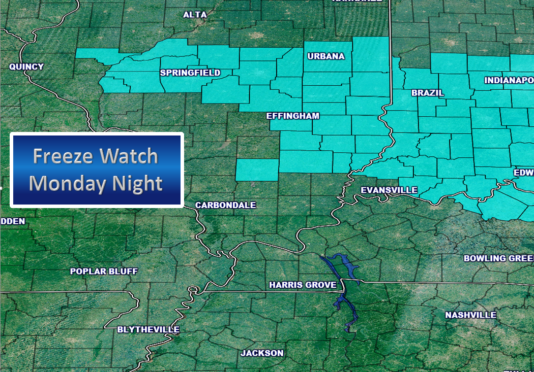
This forecast update covers far southern Illinois, far southeast Missouri, and far western Kentucky. See the coverage map on the right side of the blog.
Remember that weather evolves. Check back frequently for updates, especially during active weather.

FROST FORECAST:
Frost update for the orchards/others.
Sunday night – no frost anticipated.
Monday night – There is a 50% chance for a frost or freeze. Dry air might help our cause when it comes to frost.
Tuesday night – Frost is not anticipated
Wednesday night – Not concerned about frost.
Thursday night – Small chance for frost.
Friday night – Decent shot at freezing temperatures in the region. Monitor updates.
Sunday Night – Mostly clear and not as cold.
Temperatures: Lows in the 46 to 52 degree range.
Winds: South and southwest winds at 8-16 mph
What is the chance for precipitation? 0%
Coverage of precipitation? None
My confidence in this part of the forecast verifying is High
Should I be concerned about snow or ice? No
Should I cancel my outdoor plans? No
Is severe weather expected? No
What impact is expected? None
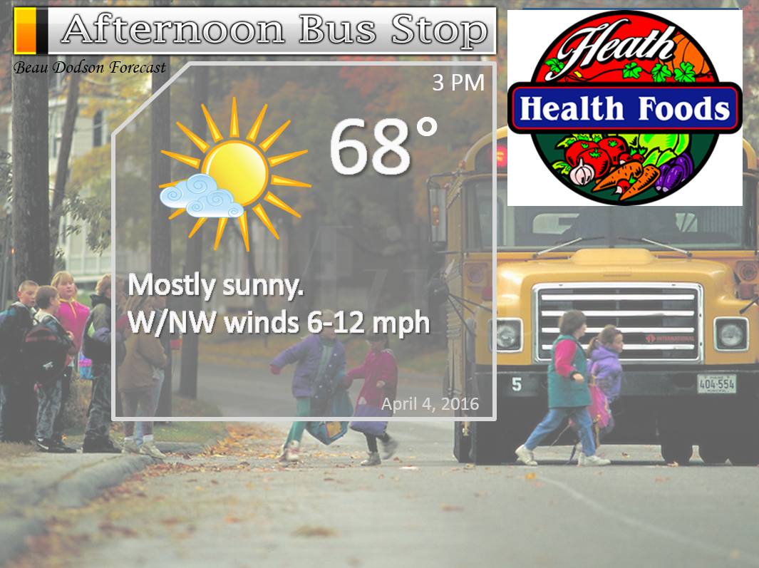
Monday – Some clouds from time to time. Small chance for sprinkles.
Temperatures: High temperatures in the 65 to 70 degree range. Cooler over northern parts of southern Illinois.
Winds: Southwest and west winds at 8-16 mph. Winds becoming northwest behind the cold front.
What is the chance for precipitation? 10%-20%
Coverage of precipitation? A sprinkle possible
My confidence in this part of the forecast verifying is High
Should I be concerned about snow or ice? No
Should I cancel my outdoor plans? No
Is severe weather expected? No
What impact is expected? None
Monday Night – Mostly clear and cold. Frost and or freeze possible.
Temperatures: Lows in the lower to middle 30s. Upper 20s possible in the freeze warning zone.
Winds: Light winds from the northeast at 4-8 mph. Gusts to 12 mph.
What is the chance for precipitation? 0%
Coverage of precipitation? None
My confidence in this part of the forecast verifying is High
Should I be concerned about snow or ice? No
Should I cancel my outdoor plans? No
Is severe weather expected? No
What impact is expected? Frost and/or freeze possible.
Tuesday – Mostly sunny. Colder.
Temperatures: High temperatures in the upper 50s to lower 60s.
Winds: Light and variable winds at 4-8 mph. Gusts to 12 mph.
What is the chance for precipitation? 0%
Coverage of precipitation? None
My confidence in this part of the forecast verifying is High
Should I be concerned about snow or ice? No
Should I cancel my outdoor plans? No
Is severe weather expected? No
What impact is expected? None
Tuesday Night – Increasing clouds. Perhaps a shower or thunderstorm after midnight.
Temperatures: Lows in the lower to middle to upper 40s.
Winds: East and southeast winds at 5-10 mph. Gusts to 20 mph after midnight.
What is the chance for precipitation? 20%-30%
Coverage of precipitation? None to isolated. If the front advances quicker than anticipated then I will have to increase the rain chances a bit.
My confidence in this part of the forecast verifying is Medium
Should I be concerned about snow or ice? No
Should I cancel my outdoor plans? No
Is severe weather expected? No
What impact is expected? Maybe wet roadways if showers do develop.
Wednesday – Becoming cloudy. A chance for a shower or thunderstorm. Increasing chances through the day.
Temperatures: High temperatures in the middle to upper 60s
Winds: South and southwest winds at 8-16 mph. Gusts to 35 mph.
What is the chance for precipitation? 60%-70%
Coverage of precipitation? Scattered to perhaps widespread
My confidence in this part of the forecast verifying is High
Should I be concerned about snow or ice? No
Should I cancel my outdoor plans? Some rain possible
Is severe weather expected? Unlikely
What impact is expected? Lightning. Wet roadways.
Wednesday Night – Cloudy. A chance for showers and thunderstorms.
Temperatures: Lows in the lower to middle 40s.
Winds: Winds becoming west and northwest at 8-16 mph early and 5-10 mph late.
What is the chance for precipitation? 30%-40%
Coverage of precipitation? Scattered
My confidence in this part of the forecast verifying is High
Should I be concerned about snow or ice? No
Should I cancel my outdoor plans? Some showers possible
Is severe weather expected? Unlikely
What impact is expected? Maybe wet roadways if showers do develop.
Thursday – Mix of sun and clouds.
Temperatures: High temperatures in the 58-64 degree range. Warmer west vs east in the region. Southeast Missouri should be the warmest.
Winds: Northwest winds at 8-16 mph.
What is the chance for precipitation? 10%
Coverage of precipitation? Isolated
My confidence in this part of the forecast verifying is High
Should I be concerned about snow or ice? No
Should I cancel my outdoor plans? No
Is severe weather expected? No
What impact is expected? Wet roadways if anything at all.
Thursday Night – Partly cloudy. A shower possible.
Temperatures: Lows in the 36 to 42 degree range
Winds: Winds becoming west and northwest at 8-16 mph.
What is the chance for precipitation? 30%
Coverage of precipitation? Isolated to Scattered
My confidence in this part of the forecast verifying is Medium
Should I be concerned about snow or ice? No
Should I cancel my outdoor plans? No
Is severe weather expected? No
What impact is expected? None
Friday – Colder. Clouds. a chance for a shower.
Temperatures: High temperatures in the middle to upper 40s
Winds: Northwest winds at 8-16 mph. Diminishing late in the date to less than 10 mph.
What is the chance for precipitation? 10%
Coverage of precipitation? Isolated
My confidence in this part of the forecast verifying is Medium
Should I be concerned about snow or ice? No
Should I cancel my outdoor plans? No
Is severe weather expected? No
What impact is expected? Maybe wet roadways.
The School Bus Stop Forecast is sponsored by Heath Health and Wellness. Located next to Crowell Pools in Lone Oak, Kentucky.
Visit their web-site here. And. visit Heath Health Foods on Facebook!

The School Bus Stop Forecast is sponsored by Heath Health and Wellness. Located next to Crowell Pools in Lone Oak.

Heath Health Foods is a locally owned and operated retail health and wellness store. Since opening in February 2006; the store has continued to grow as a ministry with an expanding inventory which also offers wellness appointments and services along with educational opportunities. Visit their web-site here. And. visit Heath Health Foods on Facebook!

Don’t forget to check out the Southern Illinois Weather Observatory web-site for weather maps, tower cams, scanner feeds, radars, and much more! Click here

An explanation of what is happening in the atmosphere over the coming days…
- Cold front arrives on Monday. Small shower chances.
- Monday night will be cold
- Rain chances increase late Tuesday night and especially on Wednesday
- Unsettled Thursday and Friday. Cooler.
- Frost or freeze possible on Saturday morning.
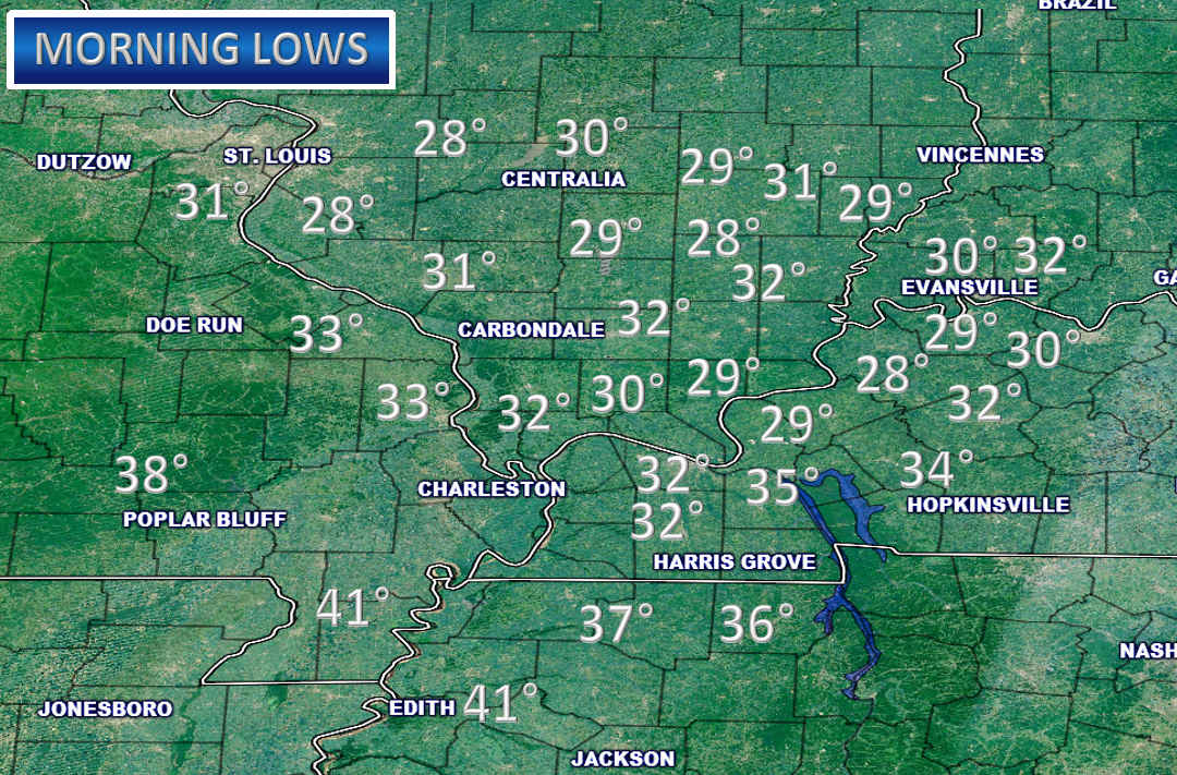
Brrrr. The region woke up to cold temperatures on Sunday morning. Widespread upper 20s to middle 30s over the region. Parts of southeast Missouri and the Missouri Bootheel were not as cold. The coldest air was situated over southeast Illinois and northwest Kentucky.
Here are some of the official and unofficial low temperatures. Some of the unofficial reporting stations can be over/under one or two degrees in accuracy. And, cold favored spots can be quite a bit colder than surrounding areas. You probably know who you are!
The main weather story over the coming week will be rain showers and perhaps a few thunderstorms on Wednesday and then several cold shots.
A cold front will push through our region on Monday afternoon and evening. A few clouds and maybe a light shower will accompany the front. Mostly dry. Colder air filters back into the region late Monday night and Tuesday morning. Temperatures could once again dip into the freezing range. Dry air might help prevent widespread frost. Monitor updates if you have vegetation concerns.
A stronger cold front arrives Tuesday night and Wednesday. This front will be accompanied by a band of showers and thunderstorms. Not anticipating severe weather. And, rainfall totals should be fairly light. Mostly in the 0.10″-0.40″ range. A thunderstorm can always drop locally heavier totals. As is usually the case.
Clouds and a few light showers might linger in the region on Thursday and Friday. Especially true for Thursday night and Friday. Another cold front moves through the region on Friday. The coldest air of the week might spread into our region Friday night and Saturday morning. Lows in the upper 20s to lower 30s will once again be possible. Still a bit early for specifics on the frost/freeze risk Friday night. Hopefully temperatures will moderate a little bit as we move forward. I will keep a close eye on trends.
Another system will enter the region around the 11th-13th of April. Showers and thunderstorms again possible.
We made it through March with only a couple of severe weather events. A few tornadoes on Easter Sunday and then the other event last week. But, for the most part there was not any widespread severe weather outbreaks in our region. Now we just need to make it through April!
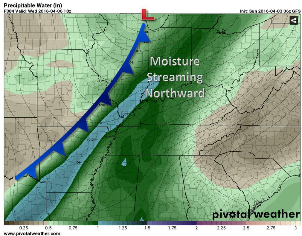
Let’s pull up a few Weatherbell.com guidance maps. Let’s check out the cold front on Wednesday. This is the GFS model guidance.
This first map is the PWAT value map. PWAT is a measure of moisture in the atmosphere. Decent moisture recovery (coming in after our very low dew points). So, this means the front will have some moisture to work with. I do expect widespread showers along the front. And, some thunderstorms. The blue colors represents moisture pooling ahead of the cold front.
What are PWAT values? Great question! I found this blog post that explains it quite well. Click here for more information on PWAT values.
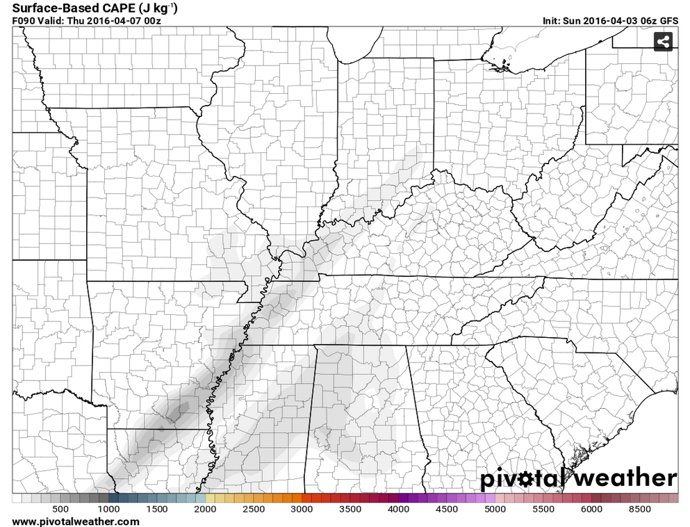
Let’s look at the surface based CAPE map for Wednesday. Not much CAPE on this map. CAPE is a measure of energy in the atmosphere. Higher CAPE equals stronger thunderstorms. Not much to work with on Wednesday. Which, is good news. We don’t want severe storms.
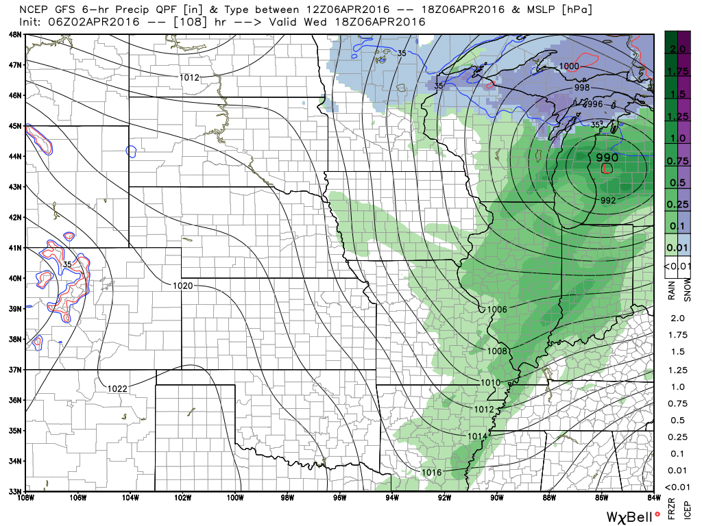
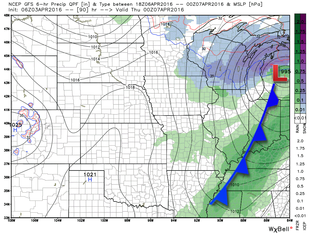
Here is the storm system as it approaches are region late Tuesday night and Wednesday morning. A cold front trails from eastern Iowa into Missouri. The low is centered over eastern Iowa. Showers and thunderstorms will develop along and ahead of the cold front. Right now the severe weather risk looks minimal. Not anticipating severe storms.

Here is the weather map for Wednesday at 1 pm. You can see green over our region. Some showers and storms. The low is moving into Michigan. Cold front trails back into our region.
Here is the Wednesday evening weather map. Cold front moving through our region. Still some showers and storms. Check out the snow over Wisconsin.
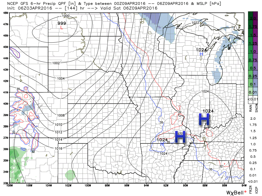
Moving ahead to the next cold front.
This is the weather map for Thursday evening. Another disturbance dives down from the northwest. We might have some light showers in the region on Thursday and Friday.

Here is the Friday afternoon weather map. The GFS even shows a rain/snow mix in the region. If nothing else this is a testament to colder temperatures anticipated on Friday and Saturday.

The map below is for Friday night.
Cold high pressure builds into the region on Friday night. We might have to deal with another frost/freeze situation.
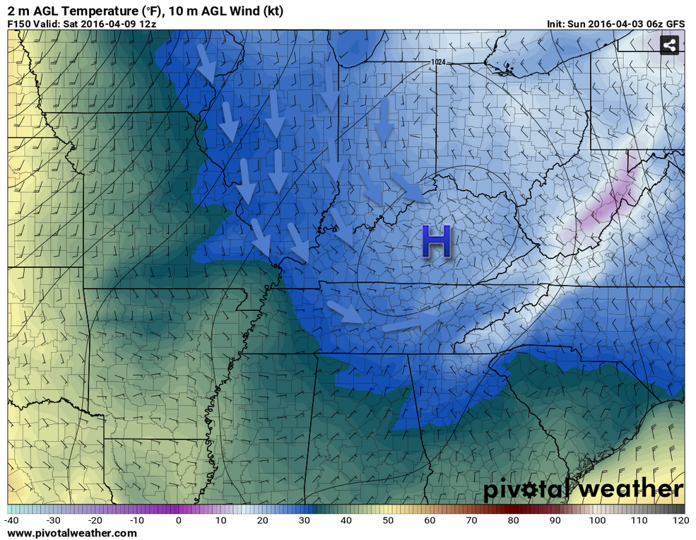
We look at the 500 mb map for next weekend. Deep trough over the Eastern United States. A trough is a dip in the jet stream. That means cold weather again. See how the jet stream dives down from Canada into our region? Bringing with it below normal temperatures, of course. How cold will next Friday and Saturday end up being? Well, that is a good question. We may have another shot at freeze warnings. Still a bit early to know for sure.

Here is the temperature map for next Saturday morning
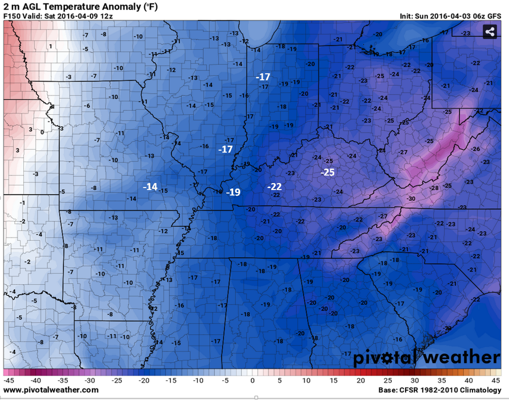
How many degrees below normal will temperatures be next Saturday? This map shows you. These are not air temperatures. These are departures. In other words how many degrees above or below normal. Some big numbers. Well below normal temperatures.
Maybe spring will shot up sooner than later. Hope so!

Can we expect severe thunderstorms over the next 24 to 48 hours? Remember that a severe thunderstorm is defined as a thunderstorm that produces 58 mph winds or higher, quarter size hail or larger, and/or a tornado.
.
No thunderstorms expected through Tuesday. Small chance late Tuesday night for lightning. Better chances on Wednesday.
Level ONE threat for storms on Wednesday and Wednesday night. Lightning would be the main concern. Severe weather is currently not anticipated.

.

Updated temperatures.
.

Frost and freeze possible Saturday night.
Frost update for the orchards/others.
Sunday night – no frost anticipated.
Monday night – There is a 50% chance for frost and/or a freeze. Coldest locations will likely be southwest Illinois and northwest Kentucky.
Tuesday night – Frost is not anticipated
Wednesday night – Not concerned about frost.
Thursday night – Frost is possible.
Friday night – Frost and/or freeze will be possible.

Another frost or freeze is possible on Tuesday morning.
Coldest night of the upcoming week might be Friday night/Saturday morning. Another chance for frost/freeze during that time frame.
Thunderstorms on Wednesday. Lightning is the main concern. At this time the threat for severe storms appears very small.

How much precipitation should we expect over the next few days?
Small chance for a light shower on Monday. Rainfall totals less than 0.10″ (if any at all).
Better chance for showers and thunderstorms on Tuesday night into Wednesday evening. Best chance on Wednesday. Some light showers possible Thursday and Friday. Some of the data indicates a rain/snow mix in the Ohio Valley Friday afternoon and evening.
Rainfall totals on Wednesday might range from 0.10″-0.40″. Right now this does not look like a significant rain event.
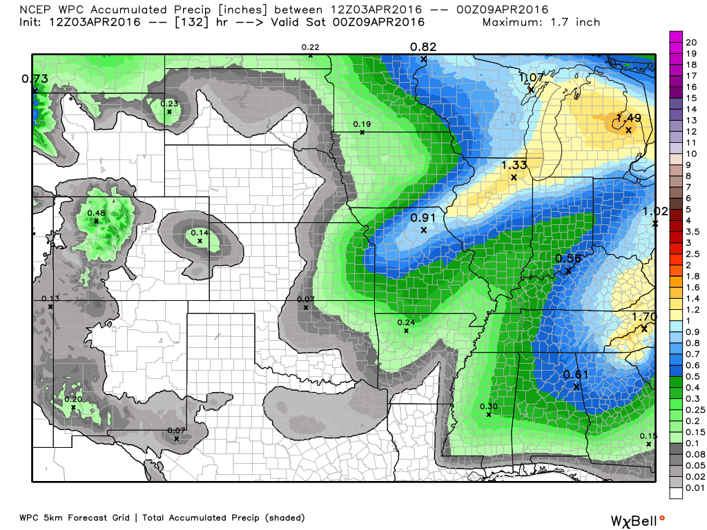
Here are the current rainfall totals for the upcoming week. Subject to changes. Thunderstorms can always produce locally heavy rainfall totals.

Here are the current river stage forecasts. You can click your state and then the dot for your location. It will bring up the full forecast and hydrograph.

Here is the official 6-10 day and 8-14 day temperature and precipitation outlook. Check the date stamp at the top of each image (so you understand the time frame).
The forecast maps below are issued by the Weather Prediction Center (NOAA).


The latest 8-14 day temperature and precipitation outlook. Note the dates are at the top of the image. These maps DO NOT tell you how high or low temperatures or precipitation will be. They simply give you the probability as to whether temperatures or precipitation will be above or below normal.


Who do you trust for your weather information and who holds them accountable?
I have studied weather in our region since the late 1970’s. I have 37 years of experience in observing our regions weather patterns. My degree is in Broadcast Meteorology from Mississippi State University and an Associate of Science (AS). I am currently working on my Bachelor’s Degree in Geoscience.
My resume includes:
Member of the American Meteorological Society.
NOAA Weather-Ready Nation Ambassador.
Meteorologist for McCracken County Emergency Management. I served from 2005 through 2015.
I own and operate the Southern Illinois Weather Observatory.
Recipient of the Mark Trail Award, WPSD Six Who Make A Difference Award, Kentucky Colonel, and the Caesar J. Fiamma” Award from the American Red Cross.
In 2009 I was presented with the Kentucky Office of Highway Safety Award.
Recognized by the Kentucky House of Representatives for my service to the State of Kentucky leading up to several winter storms and severe weather outbreaks.
I am also President of the Shadow Angel Foundation which serves portions of western Kentucky and southern Illinois.
There is a lot of noise on the internet. A lot of weather maps are posted without explanation. Over time you should learn who to trust for your weather information.
My forecast philosophy is simple and straight forward.
- Communicate in simple terms
- To be as accurate as possible within a reasonable time frame before an event
- Interact with you on Twitter, Facebook, and the blog
- Minimize the “hype” that you might see on television or through other weather sources
- Push you towards utilizing wall-to-wall LOCAL TV coverage during severe weather events
I am a recipient of the Mark Trail Award, WPSD Six Who Make A Difference Award, Kentucky Colonel, and the Caesar J. Fiamma” Award from the American Red Cross. In 2009 I was presented with the Kentucky Office of Highway Safety Award. I was recognized by the Kentucky House of Representatives for my service to the State of Kentucky leading up to several winter storms and severe weather outbreaks.
If you click on the image below you can read the Kentucky House of Representatives Resolution.

Many of my graphics are from www.weatherbell.com – a great resource for weather data, model data, and more


You can sign up for my AWARE email by clicking here I typically send out AWARE emails before severe weather, winter storms, or other active weather situations. I do not email watches or warnings. The emails are a basic “heads up” concerning incoming weather conditions.