
April 28, 2018
Saturday Forecast Details
Forecast: Mostly sunny. Mild temperatures.
Temperatures: MO ~ 64 to 68 IL ~ 60 to 66 (coolest near Mt Vernon) KY ~ 63 to 68 TN ~ 64 to 68
What is the chance of precipitation? MO ~ 0% IL ~ 0% KY ~ 0% TN ~ 0%
Coverage of precipitation: None
Winds: Wind from the north at 10 to 20 mph with gusts to 25 mph
What impacts are anticipated from the weather? Gusty winds for boaters
My confidence in the forecast verifying: High
Is severe weather expected? No
The NWS defines severe weather as 58 mph wind or great, 1″ hail or larger, and/or tornadoes
Should I cancel my outdoor plans? No
Sunrise: 6:03 AM
Saturday Night Forecast Details:
Forecast: Mostly clear. Cool. Patchy fog possible. Monitor frost chances.
Temperatures: MO ~ 36 to 40 IL ~ 34 to 40 KY ~ 34 to 40 TN ~ 38 to 42
What is the chance of precipitation? MO ~ 0% IL ~ 0% KY ~ 0% TN ~ 0%
Coverage of precipitation: None
Winds: North wind at 10 to 20 mph early becoming 5 to 10 mph late.
What impacts are anticipated from the weather? Frost possible
My confidence in the forecast verifying: High
Is severe weather expected? No
The NWS defines severe weather as 58 mph wind or great, 1″ hail or larger, and/or tornadoes
Should I cancel my outdoor plans? No
Sunset: 7:40 PM
April 29, 2018
Sunday Forecast Details
Forecast: Mostly sunny. Mild.
Temperatures: MO ~ 64 to 66 IL ~ 63 to 66 KY ~ 63 to 66 TN ~ 64 to 68
What is the chance of precipitation? MO ~ 0% IL ~ 0% KY ~ 0% TN ~ 0%
Coverage of precipitation: None
Winds: East and northeast wind at 5 to 10 mph
What impacts are anticipated from the weather? None
My confidence in the forecast verifying: High
Is severe weather expected? No
The NWS defines severe weather as 58 mph wind or great, 1″ hail or larger, and/or tornadoes
Should I cancel my outdoor plans? No
Sunrise: 6:02 AM
Sunday Night Forecast Details:
Forecast: Mostly clear. Cool.
Temperatures: MO ~ 40 to 45 IL ~ 40 to 45 KY ~ 40 to 44 TN ~ 43 to 46
What is the chance of precipitation? MO ~ 0% IL ~ 0% KY ~ 0% TN ~ 0%
Coverage of precipitation: None
Winds: East and southeast at 4 to 8 mph
What impacts are anticipated from the weather? None
My confidence in the forecast verifying: High
Is severe weather expected? No
The NWS defines severe weather as 58 mph wind or great, 1″ hail or larger, and/or tornadoes
Should I cancel my outdoor plans? No
Sunset: 7:41 PM
April 30, 2018
Monday Forecast Details
Forecast: Mostly sunny. Warmer.
Temperatures: MO ~ 72 to 76 IL ~ 72 to 76 KY ~ 72 to 76 TN ~ 72 to 76
What is the chance of precipitation? MO ~ 0% IL ~ 0% KY ~ 0% TN ~ 0%
Coverage of precipitation: None
Winds: South and southeast at 7 to 14 mph with gusts to 18
What impacts are anticipated from the weather? None
My confidence in the forecast verifying: High
Is severe weather expected? No
The NWS defines severe weather as 58 mph wind or great, 1″ hail or larger, and/or tornadoes
Should I cancel my outdoor plans? No
Sunrise: 6:01 AM
Monday Night Forecast Details:
Forecast: A few clouds. Otherwise, clear sky conditions and mild.
Temperatures: MO ~ 50 to 55 IL ~ 50 to 55 KY ~ 50 to 55 TN ~ 52 to 55
What is the chance of precipitation? MO ~ 0% IL ~ 0% KY ~ 0% TN ~ 0%
Coverage of precipitation: None
Winds: South at 6 to 12 mph
What impacts are anticipated from the weather? None
My confidence in the forecast verifying: High
Is severe weather expected? No
The NWS defines severe weather as 58 mph wind or great, 1″ hail or larger, and/or tornadoes
Should I cancel my outdoor plans? No
Sunset: 7:42 PM
May 1, 2018
Tuesday Forecast Details
Forecast: Mostly sunny. Warmer.
Temperatures: MO ~ 77 to 84 IL ~ 77 to 82 KY ~ 77 to 82 TN ~ 77 to 82
What is the chance of precipitation? MO ~ 0% IL ~ 0% KY ~ 0% TN ~ 0%
Coverage of precipitation: None
Winds: South and southwest wind 7 to 14 mph with gusts to 25 mph
What impacts are anticipated from the weather? None
My confidence in the forecast verifying: High
Is severe weather expected? No
The NWS defines severe weather as 58 mph wind or great, 1″ hail or larger, and/or tornadoes
Should I cancel my outdoor plans? No
Sunrise: 5:59 AM
Tuesday Night Forecast Details:
Forecast: Mostly clear to partly cloudy. Mild. An isolated shower possible over western portions of southeast Missouri.
Temperatures: MO ~ 62 to 65 IL ~ 62 to 65 KY ~ 63 to 65 TN ~ 63 to 65
What is the chance of precipitation? MO ~ 10% IL ~ 0% KY ~ 0% TN ~ 0%
Coverage of precipitation: None to isolated (MO)
Winds: South 6 to 12 mph
What impacts are anticipated from the weather? Most likely none.
My confidence in the forecast verifying: High
Is severe weather expected? No
The NWS defines severe weather as 58 mph wind or great, 1″ hail or larger, and/or tornadoes
Should I cancel my outdoor plans? No
Sunset: 7:43 PM
May 2, 2018
Wednesday Forecast Details
Forecast: Partly sunny. An isolated thunderstorm possible. The probability numbers will change as confidence in the forecast increases.
Temperatures: MO ~ 77 to 82 IL ~ 76 to 80 KY ~ 78 to 82 TN ~ 78 to 82
What is the chance of precipitation? MO ~ 20% IL ~ 20% KY ~ 20% TN ~ 20%
Coverage of precipitation: None to isolated over southeast Missouri
Winds: South and southwest wind 10 to 20 mph and gusty.
What impacts are anticipated from the weather? Monitor storm chances. Wet roads and lightning would be the concern. A low-end risk of a strong thunderstorm.
My confidence in the forecast verifying: Medium
Is severe weather expected? Widespread severe weather is unlikely. An isolated storm could become intense with gusty winds and hail.
The NWS defines severe weather as 58 mph wind or great, 1″ hail or larger, and/or tornadoes
Should I cancel my outdoor plans? No, but glance at radars from time to time. Isolated storms are possible.
Sunrise: 5:58 AM
Wednesday Night Forecast Details:
Forecast: Partly cloudy. A thunderstorm possible. Breezy. The probability numbers will change as confidence in the forecast increases.
Temperatures: MO ~ 68 to 72 IL ~ 66 to 70 KY ~ 66 to 70 TN ~ 68 to 72
What is the chance of precipitation? MO ~ 20% IL ~ 20% KY ~ 20% TN ~ 20%
Coverage of precipitation: Isolated to widely scattered
Winds: South and southwest at 8 to 16 mph
What impacts are anticipated from the weather? Wet roadways. Lightning. Monitor the risk of a strong thunderstorm or two.
My confidence in the forecast verifying: Medium
Is severe weather expected? A low-end risk of isolated strong thunderstorms.
The NWS defines severe weather as 58 mph wind or great, 1″ hail or larger, and/or tornadoes
Should I cancel my outdoor plans? No, but monitor radars
Sunset: 7:44 PM
May 3, 2018
Thursday Forecast Details
Forecast: Mostly cloudy. Widely scattered showers and thunderstorms. The probability numbers will change as confidence in the forecast increases.
Temperatures: MO ~ 75 to 82 IL ~ 77 to 82 KY ~ 78 to 82 TN ~ 78 to 82
What is the chance of precipitation? MO ~ 30% IL ~ 30% KY ~ 30% TN ~ 30%
Coverage of precipitation: Widely scattered
Winds: South at 10 to 20 mph and gusty
What impacts are anticipated from the weather? A few wet roadways. Lightning.
My confidence in the forecast verifying: Medium
Is severe weather expected? Most likely no, but monitor updates.
The NWS defines severe weather as 58 mph wind or great, 1″ hail or larger, and/or tornadoes
Should I cancel my outdoor plans? No, but monitor updated forecasts and radars
Sunrise: 5:57 AM
Thursday Night Forecast Details:
Forecast: Mostly cloudy. A chance of showers and thunderstorms. The probability numbers will change as confidence in the forecast increases.
Temperatures: MO ~ 63 to 66 IL ~62 to 65 KY ~ 64 to 66 TN ~ 64 to 68
What is the chance of precipitation? MO ~ 50% IL ~ 50% KY ~ 50% TN ~ 50%
Coverage of precipitation: Scattered to perhaps numerous
Winds: South and southwest at 10 to 20 mph
What impacts are anticipated from the weather? Wet roadways. Lightning. Monitor the potential of heavy rain. Monitor the potential of strong storms.
My confidence in the forecast verifying: Medium
Is severe weather expected? Some storms could be strong. The overall severe weather risk is limited. Monitor updates, as always.
The NWS defines severe weather as 58 mph wind or great, 1″ hail or larger, and/or tornadoes
Should I cancel my outdoor plans? Monitor updates.
Sunset: 7:45 PM
May 4, 2018
Friday Forecast Details
Forecast: Partly cloudy. Showers and thunderstorms again possible. The probability numbers will change as confidence in the forecast increases.
Temperatures: MO ~ 74 to 76 IL ~ 74 to 76 KY ~ 74 to 76 TN ~ 74 to 76
What is the chance of precipitation? MO ~ 50% IL ~ 50% KY ~ 50% TN ~ 50%
Coverage of precipitation: Scattered to perhaps numerous
Winds: Southwest at 10 to 15 mph with gusts to 25 mph. Winds becoming west and northwest late in the day.
What impacts are anticipated from the weather? Wet roadways. Lightning. Perhaps heavy downpours.
My confidence in the forecast verifying: Medium
Is severe weather expected? Monitor updates
The NWS defines severe weather as 58 mph wind or great, 1″ hail or larger, and/or tornadoes
Should I cancel my outdoor plans? Monitor updates
Sunrise: 5:56 AM
Friday Night Forecast Details:
Forecast: Some evening clouds. Clearing overnight. Any remaining rain will exit to the east.
Temperatures: MO ~ 53 to 56 IL ~ 52 to 55 KY ~ 53 to 56 TN ~ 53 to 56
What is the chance of precipitation? MO ~ 0% IL ~ 0% KY ~ 10% TN ~ 10%
Coverage of precipitation: Ending. None.
Winds: North and northwest at 6 to 12 mph with gusts to 14 mph
What impacts are anticipated from the weather? None
My confidence in the forecast verifying: Medium
Is severe weather expected? No
The NWS defines severe weather as 58 mph wind or great, 1″ hail or larger, and/or tornadoes
Should I cancel my outdoor plans? No
Sunset: 7:46 PM
May 5, 2018
Saturday Forecast Details
Forecast: Mostly sunny. Mild.
Temperatures: MO ~ 72 to 75 IL ~ 72 to 75 KY ~ 73 to 75 TN ~ 73 to 75
What is the chance of precipitation? MO ~ 0% IL ~ 0% KY ~ 0% TN ~ 0%
Coverage of precipitation: None
Winds: East and northeast at 5 to 10 mph with gusts to 14 mph
What impacts are anticipated from the weather? None
My confidence in the forecast verifying: High
Is severe weather expected? No
The NWS defines severe weather as 58 mph wind or great, 1″ hail or larger, and/or tornadoes
Should I cancel my outdoor plans? No
Sunrise: 5:55 AM
Saturday Night Forecast Details:
Forecast: Mostly clear and cool.
Temperatures: MO ~ 46 to 52 IL ~ 46 to 52 KY ~ 50 to 54 TN ~ 50 to 54
What is the chance of precipitation? MO ~ 0% IL ~ 0% KY ~ 0% TN ~ 0%
Coverage of precipitation: None
Winds: Light and variable
What impacts are anticipated from the weather? Most likely none
My confidence in the forecast verifying: High
Is severe weather expected? No
The NWS defines severe weather as 58 mph wind or great, 1″ hail or larger, and/or tornadoes
Should I cancel my outdoor plans? No
Sunset: 7:47 PM
May 6, 2018
Sunday Forecast Details
Forecast: Mostly sunny.
Temperatures: MO ~ 72 to 75 IL ~ 72 to 75 KY ~ 73 to 75 TN ~ 73 to 75
What is the chance of precipitation? MO ~ 0% IL ~ 0% KY ~ 0% TN ~ 0%
Coverage of precipitation: None
Winds: East and northeast at 5 to 10 mph with gusts to 14
What impacts are anticipated from the weather? None
My confidence in the forecast verifying: Medium
Is severe weather expected? No
The NWS defines severe weather as 58 mph wind or great, 1″ hail or larger, and/or tornadoes
Should I cancel my outdoor plans? No
Sunrise: 5:54 AM
Sunday Night Forecast Details:
Forecast: A few clouds.
Temperatures: MO ~ 54 to 58 IL ~ 53 to 56 KY ~ 53 to 56 TN ~ 53 to 56
What is the chance of precipitation? MO ~ 0% IL ~ 0% KY ~ 0% TN ~ 0%
Coverage of precipitation: None
Winds: East and southeast at 5 to 10 mph
What impacts are anticipated from the weather? None
My confidence in the forecast verifying: LOW
Is severe weather expected? No
The NWS defines severe weather as 58 mph wind or great, 1″ hail or larger, and/or tornadoes
Should I cancel my outdoor plans? No
Sunset: 7:48 PM
May 7, 2018
Monday Forecast Details
Forecast: Partly cloudy. A chance of showers.
Temperatures: MO ~ 73 to 76 IL ~ 73 to 76 KY ~ 73 to 76 TN ~ 73 to 76
What is the chance of precipitation? MO ~ 20% IL ~ 20% KY ~ 20% TN ~ 20%
Coverage of precipitation:
Winds:
What impacts are anticipated from the weather?
My confidence in the forecast verifying: LOW
Is severe weather expected? No
The NWS defines severe weather as 58 mph wind or great, 1″ hail or larger, and/or tornadoes
Should I cancel my outdoor plans? No
Sunrise: 5:53 AM
Monday Night Forecast Details:
Forecast: Partly cloudy. A chance of showers.
Temperatures: MO ~ 55 to 60 IL ~ 55 to 60 KY ~ 55 to 60 TN ~ 55 to 60
What is the chance of precipitation? MO ~ 20% IL ~ 20% KY ~ 20% TN ~ 20%
Coverage of precipitation:
Winds:
What impacts are anticipated from the weather?
My confidence in the forecast verifying: LOW
Is severe weather expected? No
The NWS defines severe weather as 58 mph wind or great, 1″ hail or larger, and/or tornadoes
Should I cancel my outdoor plans? No
Sunset: 7:48 PM
May 8, 2018
Tuesday Forecast Details
Forecast: Partly sunny. A chance of showers.
Temperatures: MO ~ 74 to 78 IL ~ 74 to 78 KY ~ 74 to 78 TN ~ 74 to 78
What is the chance of precipitation? MO ~ 20% IL ~ 20% KY ~ 20% TN ~ 20%
Coverage of precipitation:
Winds:
What impacts are anticipated from the weather?
My confidence in the forecast verifying: LOW
Is severe weather expected?
The NWS defines severe weather as 58 mph wind or great, 1″ hail or larger, and/or tornadoes
Should I cancel my outdoor plans?
Sunrise: 5:52 AM
Tuesday Night Forecast Details:
Forecast: Partly cloudy. A chance of showers.
Temperatures: MO ~ 55 to 60 IL ~ 55 to 60 KY ~ 55 to 60 TN ~ 55 to 60
What is the chance of precipitation? MO ~ 20% IL ~ 20% KY ~ 20% TN ~ 20%
Coverage of precipitation:
Winds:
What impacts are anticipated from the weather?
My confidence in the forecast verifying: LOW
Is severe weather expected?
The NWS defines severe weather as 58 mph wind or great, 1″ hail or larger, and/or tornadoes
Should I cancel my outdoor plans?
Sunset: 7:49 PM
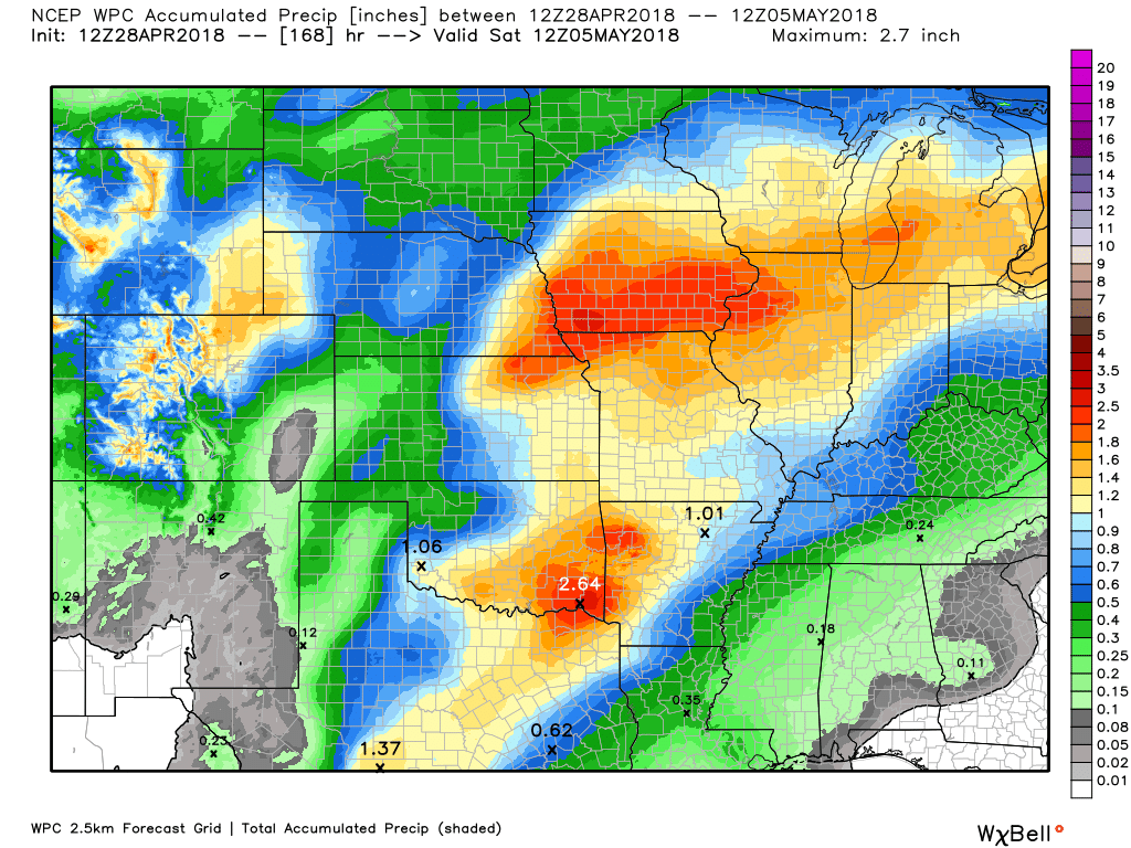
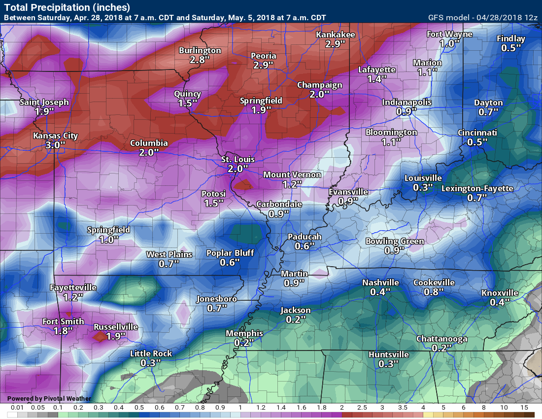
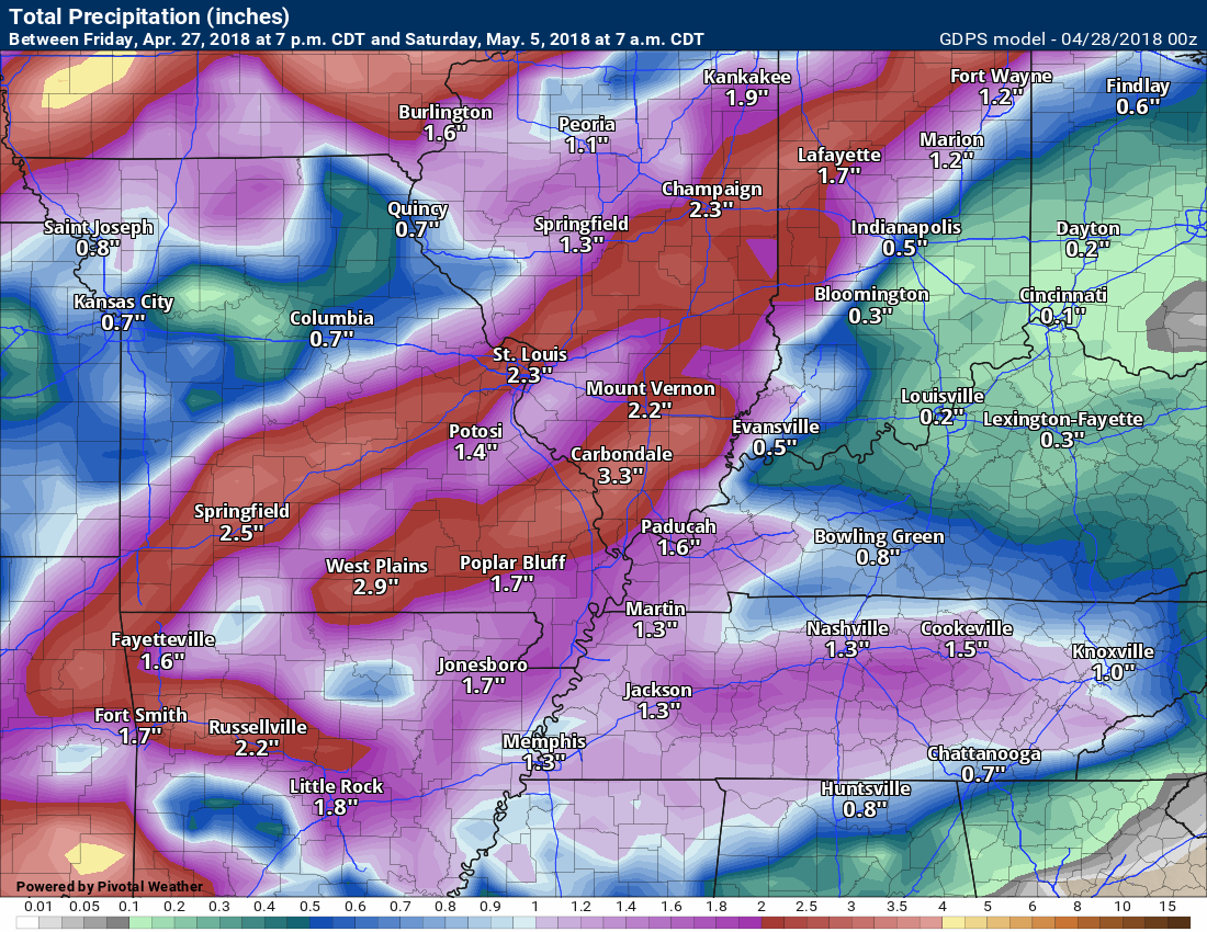
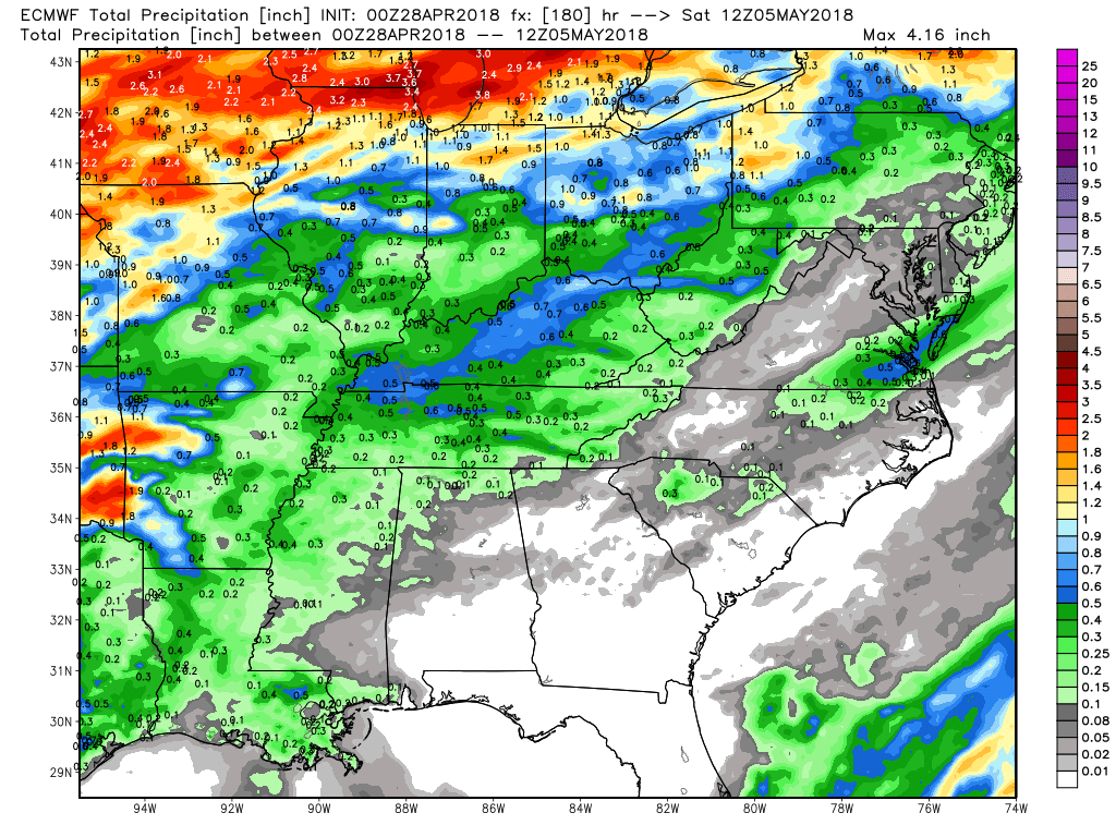
RAIN TOTALS
Locally heavy thunderstorms are possible along an incoming cold front. Data is mixed as to the timing of the front. I am confident there will be a period of showers and thunderstorms next week.
I believe the greatest chance of rain will be Thursday into Friday night. That does not mean we may not have some storms Wednesday and Wednesday night. Confidence is higher, however, on Thursday into Friday night.
These charts will not capture the potential of heavy rain. Slow moving or training thunderstorms can always produce two or three times the amount of rain forecast. Monitor updates as we will have quite a bit of moisture to work with. Some heavy rain is possible.
Why the large differences in rain totals?
Each model brings the system into the region at different times.
They will change and thunderstorms can enhance totals.
Click images to enlarge.
WPC/NOAA seven day rain forecast
GFS model guidance seven day rain forecast
Canadian model guidance seven day rain forecast
EC model guidance
Rainfall through 7 AM next Friday (notice it is the slowest of all the models)

Interactive Radars:
Interactive live weather radar page. Choose the city nearest your location. If one of the cities does not work then try a nearby one. Click here.

Questions? Broken links? Other?
You may email me at beaudodson@usawx.com

The National Weather Service defines a severe thunderstorm as one that produces quarter size hail or larger, 58 mph winds or greater, and/or a tornado.
Saturday through Tuesday: Severe weather is not anticipated.
Wednesday and Wednesday night: Monitor updates. A few thunderstorms are possible, especially over southeast Missouri. For now, confidence in storms Wednesday is rather low. Severe weather is unlikely Wednesday into Wednesday night.
Thursday through Friday night: Monitor updates. Increasing chances for thunderstorms during this time frame. A few storms could be intense. Heavy rain is a concern if thunderstorms train over the same areas.
![]()
Interactive live weather radar page. Choose the city nearest your location. If one of the cities does not work then try a nearby one. Click here.
National map of weather watches and warnings. Click here.
Storm Prediction Center. Click here.
Weather Prediction Center. Click here.

Live lightning data: Click here.

Interactive GOES R satellite. Track clouds. Click here.

Here are the latest local river stage forecast numbers Click Here.
Here are the latest lake stage forecast numbers for Kentucky Lake and Lake Barkley Click Here.

The spring and preliminary summer outlooks have been posted for subscribers. Scroll down to see the outlook.
Not a subscriber? Learn more at this link.
![]()

Weather Brains is a weekly podcast/video for those who love weather and want more!
Weather Brains episode number 640
Tonight’s WeatherBrain is the Emergency Response Meteorologist for the National Weather Service Southern Region Headquarters, Jennifer McNatt. Also joining us is Elinor Lutu-McMoore, the Meteorologist in Charge at the NWS office in Pago Pago, American Samoa.
Other discussions in this weekly podcast include topics like:
- Extremes: 103 at Thermal, CA, & Death Valley, CA, and 15 at Estcourt Station, ME
- Kevin checks out phased-array radar prototype
- Discussion on issue of differing graphics from different weather agencies
- Gulf coast tornadoes on 4/22
- Astronomy Outlook with Tony Rice
- and more!
Previous episodes can be viewed by clicking here.

We offer interactive local city live radars and regional radars. If a radar does not update then try another one. If a radar does not appear to be refreshing then hit Ctrl F5. You may also try restarting your browser.
The local city view radars also have clickable warnings.
During the winter months, you can track snow and ice by clicking the winterize button on the local city view interactive radars.
You may email me at beaudodson@usawx.com
Find me on Facebook!

Find me on Twitter!

Did you know that a portion of your monthly subscription helps support local charity projects?
You can learn more about those projects by visiting the Shadow Angel Foundation website and the Beau Dodson News website.

I encourage subscribers to use the app vs regular text messaging. We have found text messaging to be delayed during severe weather. The app typically will receive the messages instantly. I recommend people have three to four methods of receiving their severe weather information.
Remember, my app and text alerts are hand typed and not computer generated. You are being given personal attention during significant weather events.
