7 AM morning update
.
Friday, April 28, 2017:
Please download and use the app to receive the text messages. ATT and Verizon have been slow in pushing texts to your phone. The app receives the messages instantly. Sign up for the texts at www.beaudodsonweather.com and then you can download the app.
Please utilize the Apple and Android apps for your text messages. It has come to our attention that ATT and Verizon can be slow in delivering your text messages. The app is INSTANT. I barely take my finger off the enter button and my phone dings. Here is the Apple link https://itunes.apple.com/us/app/id1190136514
Here is the Android app link https://play.google.com/store/apps/details?id=com.weathertalk.beaudodsonweather.android


This forecast update covers far southern Illinois, far southeast Missouri, and far western Kentucky. See the coverage map on the right side of the blog
Thursday Night Forecast Details:
Forecast: Some clouds. A 10% for a shower. I think we should remain dry.
Temperatures: MO ~ 54 to 58 IL ~ 54 to 58 KY ~ 54 to 58 TN ~ 54 to 58
Winds: South and southeast at 5 to 10 mph
My confidence in the forecast verifying: High. This forecast should verify.
What impacts are anticipated from the weather? Most likely none.
Is severe weather expected? No
The NWS defines severe weather as 58 mph winds or great, 1″ hail or larger, and/or tornadoes
What is the chance of precipitation? MO ~ 10% IL ~ 10% KY ~ 10% TN ~ 10%
Coverage of precipitation: None to isolated.
Should I cancel my outdoor plans? No
..
April 28, 2017
Friday Forecast Details
Forecast: Partly sunny. Warm. Breezy, at times. Becoming humid. A 30% for afternoon strong thunderstorms. Flash flood watch.
Temperatures: MO ~ 76 to 82 IL ~ 76 to 82 KY ~ 76 to 82 TN ~ 76 to 82
Winds: South and southeast winds at 8 to 16 mph with gusts to 30 mph.
What impacts are anticipated from the weather? Lightning. Wet roadways. If storms break the CAP then some severe weather is possible.
My confidence in the forecast verifying: Medium. Some adjustments are possible.
Is severe weather expected? Monitor updates
The NWS defines severe weather as 58 mph winds or great, 1″ hail or larger, and/or tornadoes
What is the chance of precipitation? MO ~ 30% IL ~ 30% KY ~ 30% TN ~ 30%
Coverage of precipitation: Scattered.
Should I cancel my outdoor plans? No, but monitor updates
.
Friday night:
Forecast: Flash flood watch. There remain questions as to whether the CAP (warm air aloft) will break on Friday and Friday night. If the CAP does not break then storms won’t form south of the front. That would be good news. Low confidence on how this plays out. Cloudy. Breezy. Widespread heavy rain developing along and north of the front. Scattered severe storms possible along the front. Where the front sets up shop will determine your forecast. There remain questions on frontal boundary placement. Areas north of the front could receive three to five inches of rain. Wide temperature range from north to south.
Temperatures: MO ~ 60 to 72 IL ~ 60 to 72 KY ~ 68 to 74 TN ~ 70 to 70
Winds: South winds south of the front at 15 to 30 mph. Variable winds north of the front at 7 to 14 mph.
My confidence in the forecast verifying: Low. Significant adjustments possible.
What impacts are anticipated from the weather? Lightning. Gusty winds. Wet roadways. Flash flooding. Large hail. Damaging winds. Isolated tornadoes. Severe weather threat is low if the CAP does not break. If the CAP breaks then severe weather will occur.
Is severe weather expected? Yes. Severe weather is possible IF the CAP breaks.
The NWS defines severe weather as 58 mph winds or great, 1″ hail or larger, and/or tornadoes
What is the chance of precipitation? MO ~ 70% IL ~ 70% KY ~ 60% TN ~ 60%
Coverage of precipitation: Scattered south of the front and widespread along and north of the front.
Should I cancel my outdoor plans? Have a plan B. Monitor updated forecasts. Some storms are possible Friday night.
.
April 29, 2017
Saturday Forecast Details
Forecast: Flash flood watch. Partly to mostly cloudy. Some breaks in the clouds possible south of the front. Showers and thunderstorms possible. Again, frontal boundary placement is key to the forecast. It is possible that the greatest coverage of rain and storms will be over Missouri and Illinois on Saturday. Heavy rain possible. A few storms could be severe. Locally heavy rain possible. A wide temperature range from north to south.
Temperatures: MO ~ 64 to 82 IL ~ 84 to 78 KY ~ 74 to 80 TN ~ 76 to 82
Winds: South of the front the winds will be from the south at 6 to 12 mph with gusts to 35 mph. Variable winds north of the front at 7 to 14 mph.
What impacts are anticipated from the weather? Lightning. Wet roadways. Flash flooding. Some storms could be severe with hail and high winds.
My confidence in the forecast verifying: Low. Significant adjustments are possible.
Is severe weather expected? Possibly.
The NWS defines severe weather as 58 mph winds or great, 1″ hail or larger, and/or tornadoes
What is the chance of precipitation? MO ~ 70% IL ~ 70% KY ~ 50% TN ~ 50%
Coverage of precipitation: Scattered to widespread.
Should I cancel my outdoor plans? Have a plan B. Rain is possible.
Saturday Night Forecast Details:
Forecast: Flash flood watch. Mostly cloudy. Showers and thunderstorms likely. A few storm could be intense. Locally heavy rain possible.
Temperatures: MO ~ 65 to 74 IL ~ 65 to 72 KY ~ 68 to 74 TN ~ 68 to 74
Winds: South winds at 6 to 12 mph with gusts to 30 mph.
My confidence in the forecast verifying: Medium. Some adjustments are possible.
What impacts are anticipated from the weather? Lightning. Gusty winds. Wet roadways. Some storms could be intense. Monitor updates.
Is severe weather expected? Monitor updates.
The NWS defines severe weather as 58 mph winds or great, 1″ hail or larger, and/or tornadoes
What is the chance of precipitation? MO ~ 60% IL ~ 60% KY ~ 50% TN ~ 50%
Coverage of precipitation: Scattered to perhaps widespread.
Should I cancel my outdoor plans? have a plan B, in case it rains.
.
April 30, 2017
Sunday Forecast Details
Forecast: Partly to mostly cloudy. Showers and thunderstorms possible. Some storms could be heavy. Some intense storms possible.
Temperatures: MO ~ 76 to 82 IL ~ 76 to 82 KY ~ 76 to 82 TN ~ 76 to 82
Winds: South winds at 8 to 16 mph with gusts to 35 mph
What impacts are anticipated from the weather? Lightning. Wet roadways. Some storms could become severe. Heavy rain possible.
My confidence in the forecast verifying: Medium. Some adjustments are possible.
Is severe weather expected? Monitor updates. Some storms could be severe.
The NWS defines severe weather as 58 mph winds or great, 1″ hail or larger, and/or tornadoes
What is the chance of precipitation? MO ~ 70% IL ~ 70% KY ~ 70% TN ~ 70%
Coverage of precipitation: Increasing coverage from west to east.
Should I cancel my outdoor plans? Have a plan B.
Sunday Night Forecast Details:
Forecast: Showers likely. Some evening thunderstorms possible. Cooler.
Temperatures: MO ~ 48 to 54 IL ~ 48 to 54 KY ~ 50 to 55 TN ~ 50 to 55
Winds: Winds becoming west and northwest behind the front at 7 to 14 mph with gusts to 30 mph.
My confidence in the forecast verifying: Medium. Some adjustments are possible.
What impacts are anticipated from the weather? Evening storms could be strong with lightning, gusty winds, and hail. Once the main line passes then just remaining showers.
Is severe weather expected? Perhaps early. This will depend on how fast the front moves through the region.
The NWS defines severe weather as 58 mph winds or great, 1″ hail or larger, and/or tornadoes
What is the chance of precipitation? MO ~ 60% IL ~ 70% KY ~ 70% TN ~ 70%
Coverage of precipitation: Widespread ahead of the front. Becoming scattered as the night wears on.
Should I cancel my outdoor plans? Have a plan B.
.
May 1, 2017
Monday Forecast Details
Forecast: Mostly sunny and cooler.
Temperatures: MO ~ 64 to 68 IL ~ 64 to 68 KY ~ 64 to 68 TN ~ 64 to 68
Winds: West and southwest winds at 15 to 35 mph and gusty
What impacts are anticipated from the weather? None.
My confidence in the forecast verifying: High. This forecast should verify.
Is severe weather expected? No.
The NWS defines severe weather as 58 mph winds or great, 1″ hail or larger, and/or tornadoes
What is the chance of precipitation? MO ~ 0% IL ~ 0% KY ~ 0% TN ~ 0%
Coverage of precipitation: None.
Should I cancel my outdoor plans? No
Monday Night Forecast Details:
Forecast: Mostly clear and cool.
Temperatures: MO ~ 45 to 50 IL ~ 45 to 50 KY ~ 45 to 50 TN ~ 45 to 50
Winds: West winds at 4 to 8 mph
My confidence in the forecast verifying: High. This forecast should verify.
What impacts are anticipated from the weather? None.
Is severe weather expected? No
The NWS defines severe weather as 58 mph winds or great, 1″ hail or larger, and/or tornadoes
What is the chance of precipitation? MO ~ 0% IL ~ 0% KY ~ 0% TN ~ 0%
Coverage of precipitation: None
Should I cancel my outdoor plans? No
.
May 2, 2017
Tuesday Forecast Details
Forecast: Partly sunny.
Temperatures: MO ~ 70 to 75 IL ~ 70 to 75 KY ~ 70 to 75 TN ~ 70 to 75
Winds: Southwest and west winds at 6 to 12 mph with gusts to 15 mph
What impacts are anticipated from the weather? None
My confidence in the forecast verifying: High. This forecast should verify.
Is severe weather expected? No.
The NWS defines severe weather as 58 mph winds or great, 1″ hail or larger, and/or tornadoes
What is the chance of precipitation? MO ~ 10% IL ~ 10% KY ~ 0% TN ~ 0%
Coverage of precipitation: None
Should I cancel my outdoor plans? No
Tuesday Night Forecast Details:
Forecast: Some clouds. A shower or thunderstorm possible.
Temperatures: MO ~ 50 to 55 IL ~ 50 to 55 KY ~ 50 to 55 TN ~ 50 to 55
Winds: Variable winds at 5 to 10 mph
My confidence in the forecast verifying: Low. Significant adjustments are possible.
What impacts are anticipated from the weather?
Is severe weather expected? No
The NWS defines severe weather as 58 mph winds or great, 1″ hail or larger, and/or tornadoes
What is the chance of precipitation? MO ~ 30% IL ~ 30% KY ~ 30% TN ~ 30%
Coverage of precipitation:
Should I cancel my outdoor plans? No
.

Don’t forget to check out the Southern Illinois Weather Observatory web-site for weather maps, tower cams, scanner feeds, radars, and much more! Click here

An explanation of what is happening in the atmosphere over the coming day

Severe thunderstorm outlook.
Remember that a severe thunderstorm is defined as a thunderstorm that produces 60 mph winds or higher, quarter size hail or larger, and/or a tornado.
Thursday night: A late night shower or thunderstorm is possible, but most areas will likely remain dry.
Friday into Friday night: Most of Friday will remain dry. A few scattered showers or storms are possible. Friday night is when the weather picks up again. A band of heavy showers and thunderstorms will develop across portions of the region. The placement of the frontal boundary will determine the placement of the heavy rain.
There will be a CAP on the atmosphere most of Friday. A CAP is a warm layer aloft. This keeps thunderstorms from forming. IF the CAP breaks then severe weather is likely to occur. The greatest risk will be from 5 pm Friday through 5 am Saturday morning.
If the CAP does break, then some of the thunderstorms could produce large hail, damaging winds, and even isolated tornadoes.
Very heavy rain is likely along and north of the front. Some areas could receive 3 to 5 inches of rain on Friday night. Thunderstorms training over the same areas will be the cause of the large rainfall totals. Flash flooding is possible on Friday night/Saturday morning.
Monitor updates. I am not overly confident as to where the front become stationary. That is key to the forecast at your house.
Saturday and Saturday night:
At least some chance for storms on Saturday. If the front pushes far enough north then our rain chances would diminish. Plan on some showers and storms Saturday. I will need to fine tune the forecast moving forward.
Perhaps the greatest coverage on Saturday will be over Missouri and Illinois. Again, low confidence.
If storms do form on Saturday/Saturday night then they could produce heavy rain. There is also a risk for a few severe thunderstorms.
Sunday into Monday: A cold front will enter the region on Sunday and Sunday night. A band of showers and thunderstorms will accompany the front. Severe weather is possible. Monitor updates.
Weather analysis for the next few days:
The main weather story will be a stationary boundary that will find itself draped across our region. Multiple rounds of showers and heavy thunderstorms are anticipated along and north of the front.
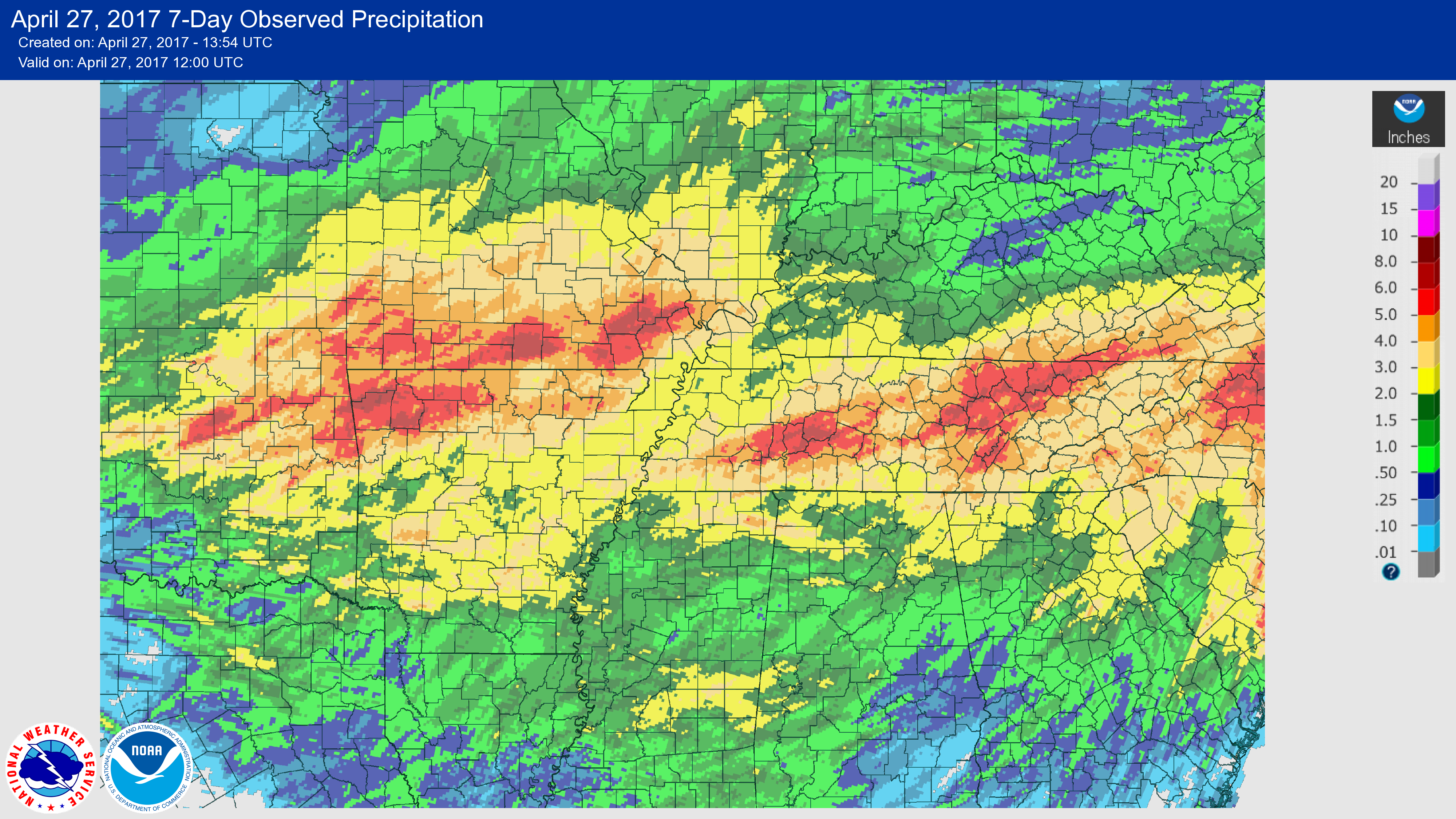
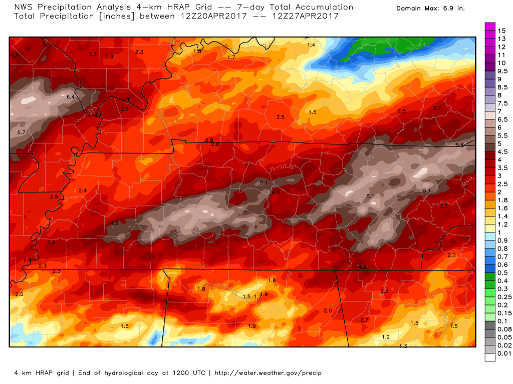
Heavy rain has already fallen across much of the area over the past seven days. Here is what has already fallen since last weekend.
Click image to enlarge
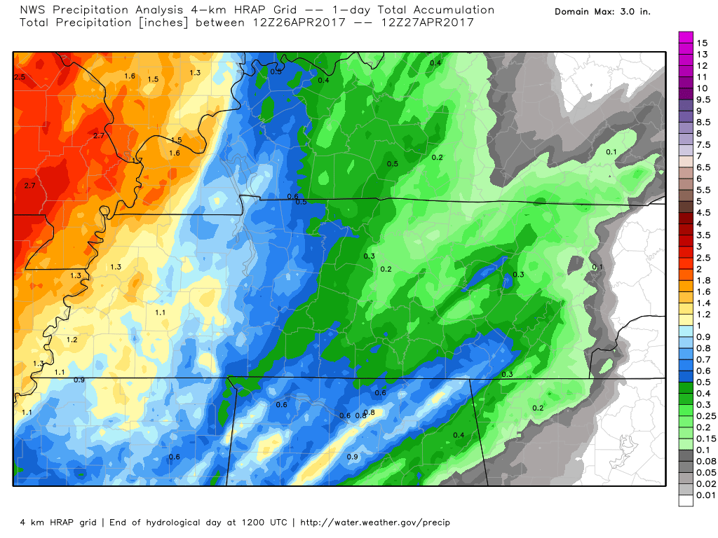
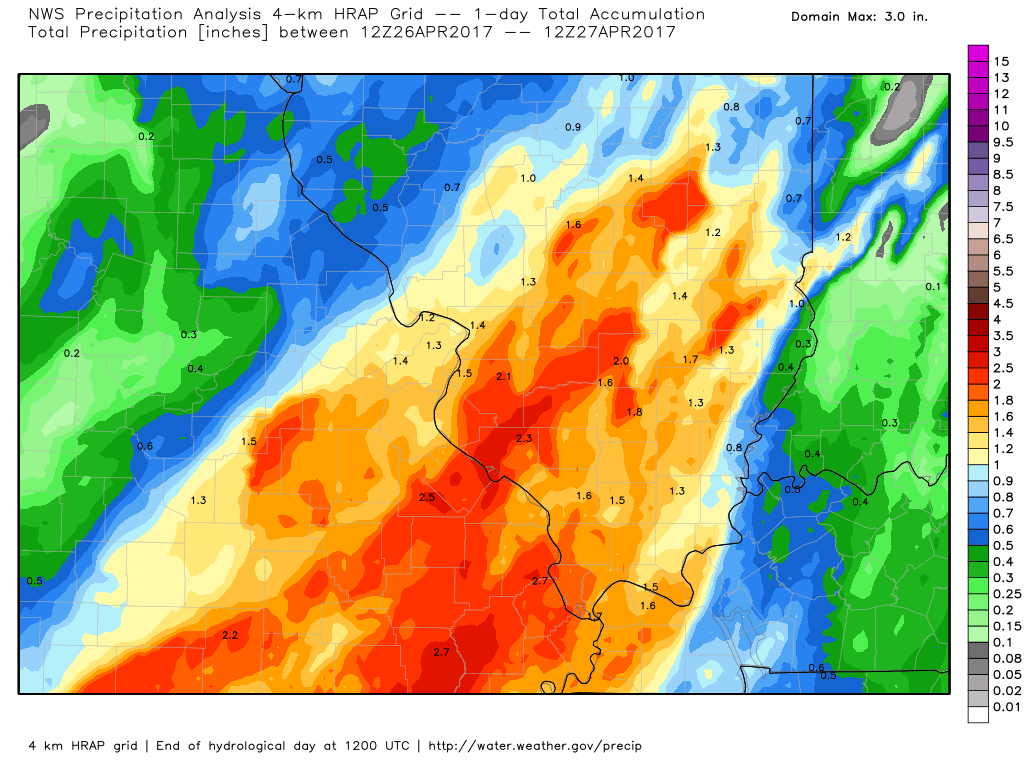
and during the last 24 hours
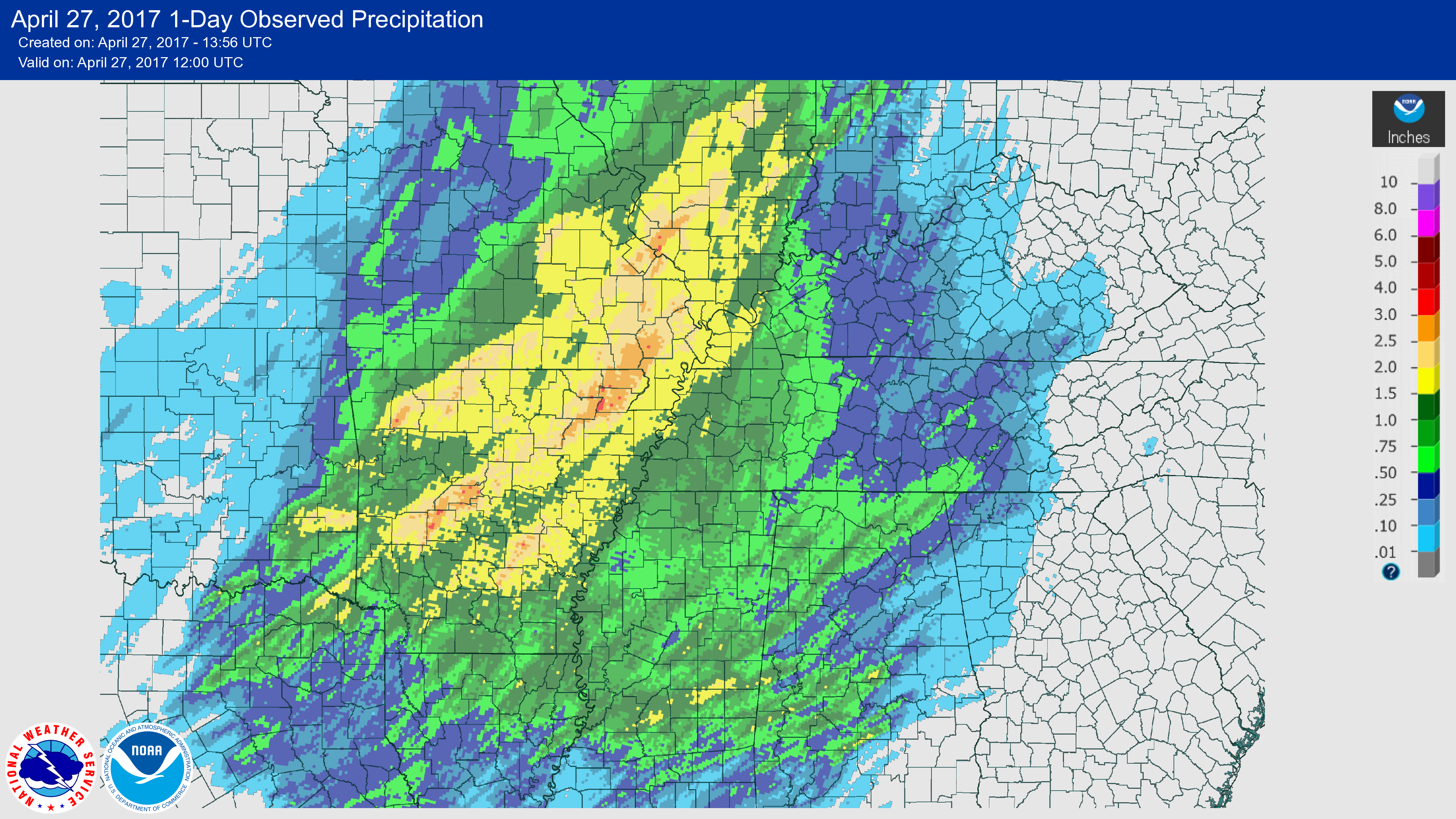
Another view
First image is the last seven days. Second image is the last 24 hours. Rainfall totals
Again
Last seven days and the last 24 hours. These are radar estimated rain totals.
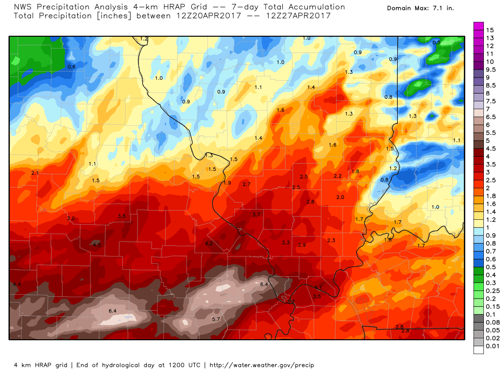
I am not overly confident as to where the front stalls out. It is important to know where the front will become stationary because this is where the heaviest rainfall totals will occur.
We should remain dry through most of Friday. Yes, a few showers or storms could form during this time period, but I suspect many will remain dry.
IF THE CAP DOES NOT BREAK ON FRIDAY/FRIDAY NIGHT THEN SEVERE WEATHER WILL BE UNLIKELY.
The severe weather part of the forecast all comes down to the CAP breaking. The CAP is warm air aloft that keeps storms from forming south of the front.
The atmosphere becomes quite unstable on Friday afternoon. CAPE numbers south of the front will pop above 1000. Lift index values of -7 to -11. Shear will be high.
Here is the NAM model forecast for CAPE
CAPE is a measure of energy that thunderstorms can tap into.
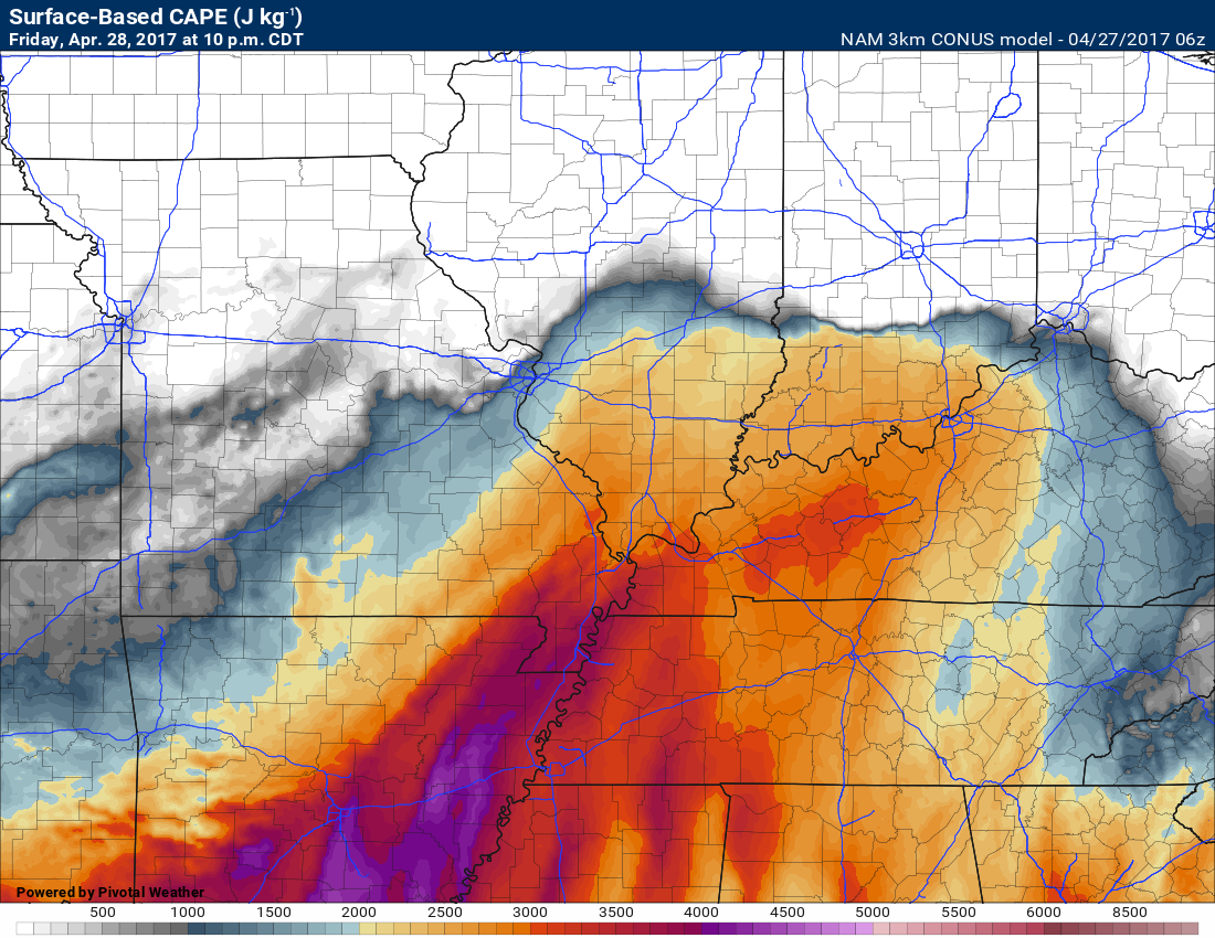
Plenty of energy for thunderstorms.
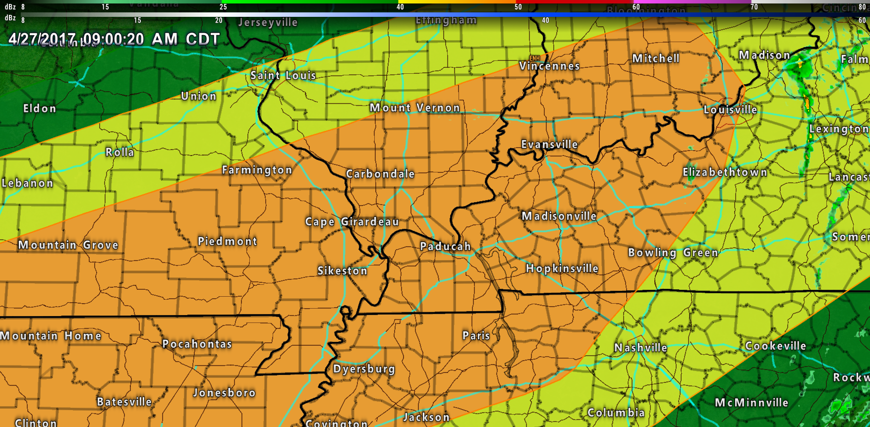
The SPC has already placed us in a significant risk zone for severe thunderstorms.
The orange is the greatest risk zone. This is for Friday afternoon into Friday night.
Orange is a level three out of five risk. Yellow is a two of out five risk zone. Dark green is a two of five risk zone.
The real question remains placement. The NAM trended further north. The EC has been favoring north. The GFS has been in the middle.
I am favoring the heaviest rain totals to fall from Poplar Bluff, MO towards Evansville, IL. Along and north of that line. Confidence is LOW.
Supercells may form south of the frontal boundary. Lines of storms may also form. Thunderstorms on Friday evening and night could produce large hail, damaging winds, and tornadoes. Monitor updates moving forward.
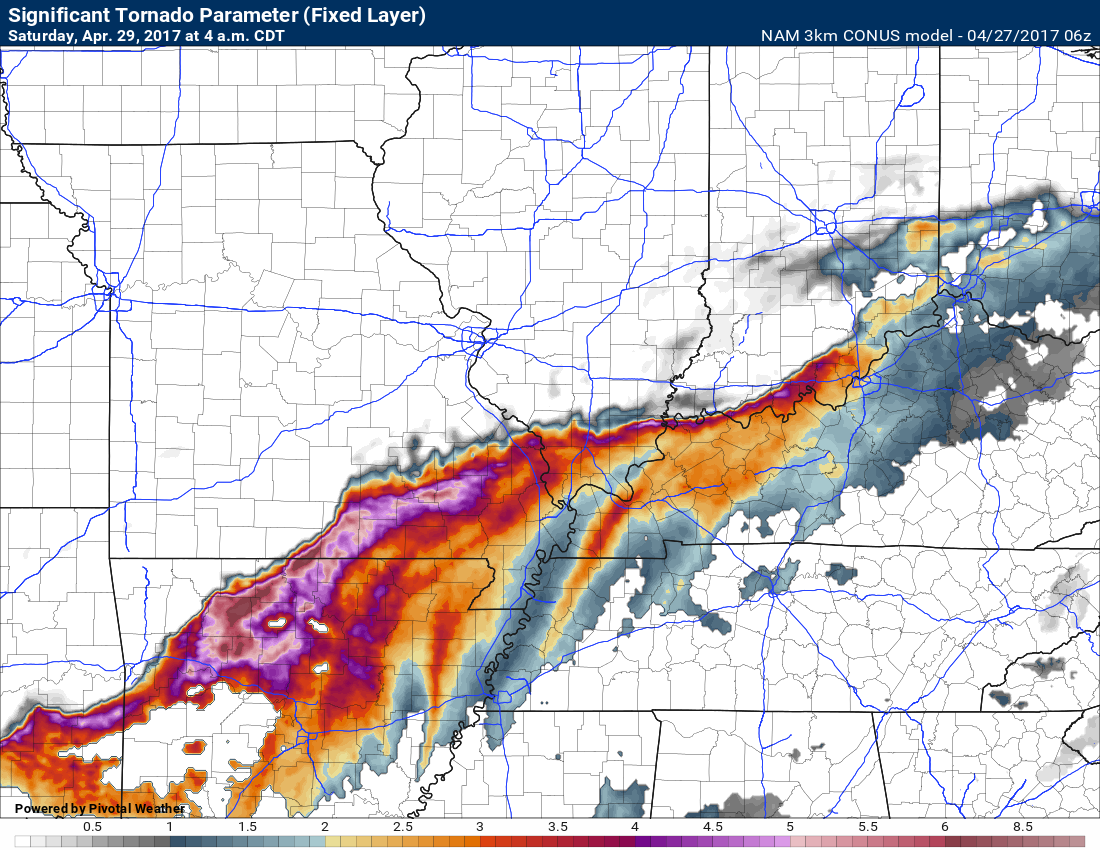
EHI numbers, along the front, will be high. This is something I typically look for when forecasting tornadoes.
This is the significant tornado parameter index. Can you find the front? Pretty easy to spot it. If storms can root into the front then spin will be enhanced. This could enhance the severe weather potential.
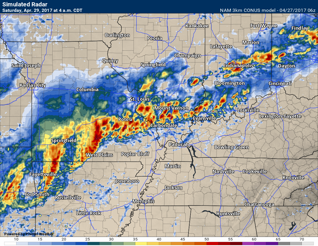
Here is the 3K NAM. High resolution model. It paints the heaviest storms north vs south.
This is 4 am on Saturday. An all night event.
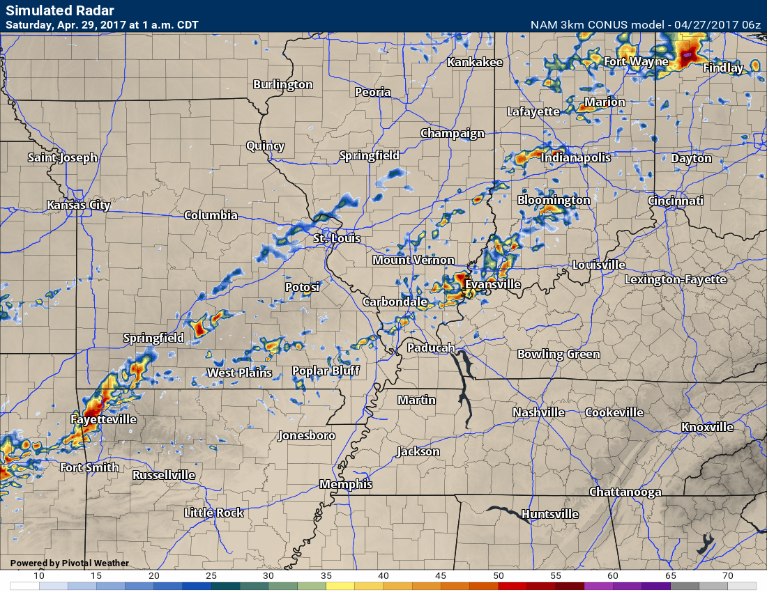
Check out this image. One of the NAM models keeps everything quiet until late Friday evening/night. This is the 10 pm future-cast radar. Not much going on.
All of this should tell you something. Confidence is not all that great as to how this all unfolds. Monitor updates frequently on Friday and Friday night.
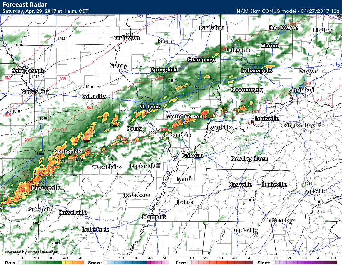
The Thursday morning run of the NAM shows the CAP not breaking. Severe weather will not occur south of the front unless the CAP breaks.
1 AM future-cast Thursday run of the NAM. Quiet south of the front.
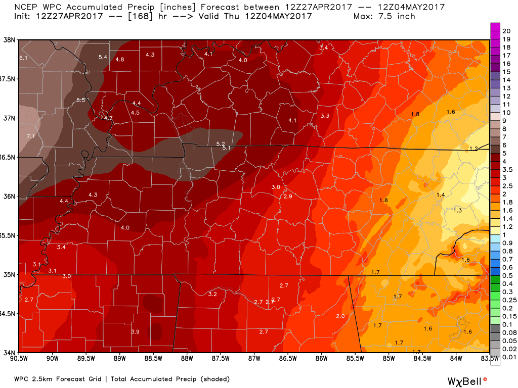
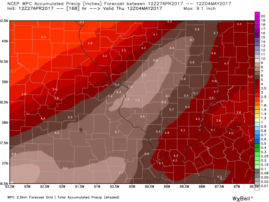
Rainfall totals will be another issue. All of the guidance paints heavy rain. The question is how much.
The St Louis NWS summed everything up. Record high PWAT values are forecast over the coming days. PWAT is a measure of moisture in the entire atmosphere. Very high numbers are forecast. These are readings you would expect in July or August.
Click image for a larger view.
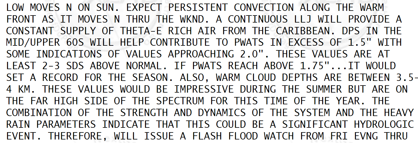
Portions of the region picked up one to four inches of rain on Wednesday and Wednesday night. An additional three to six inches of rain will be possible between now and Sunday night. Mainly along and north of the frontal boundary.
That means the greatest risk for the biggest totals will be over Missouri and Illinois.
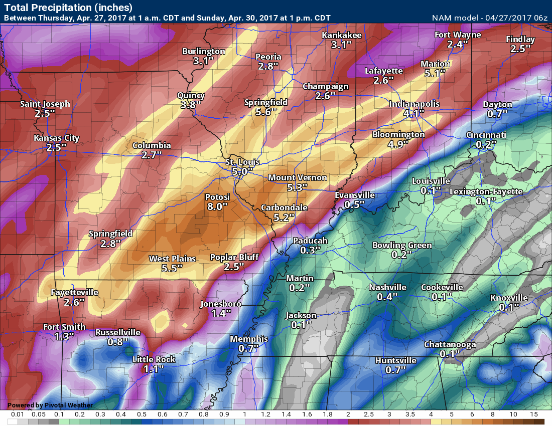
Here is what the NAM is forecasting through 1 pm on Sunday. More rain falls after 1 pm on Sunday.
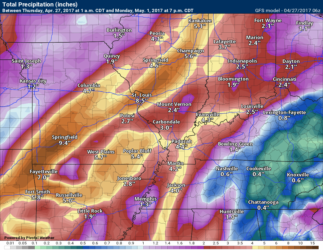
Here is what the GFS model is forecasting
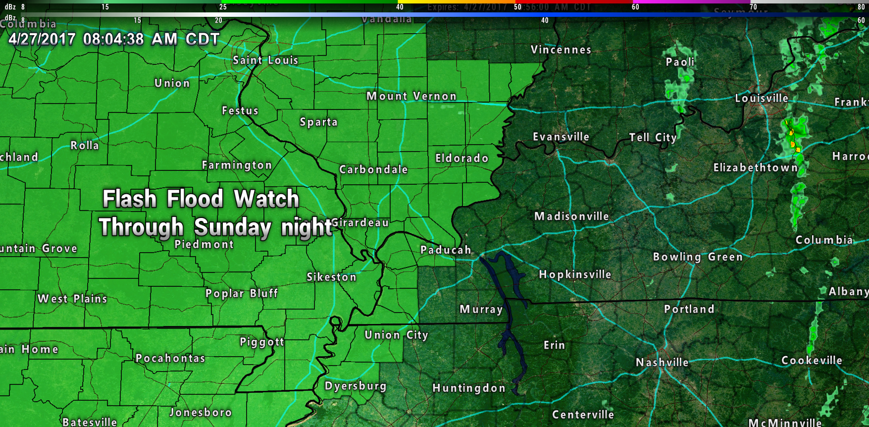
Flash flood watches blanket much of the region. Additional counties may need to be added.
There will be a large temperature spread across the front. Cooler north of the front and warmer south of the front.
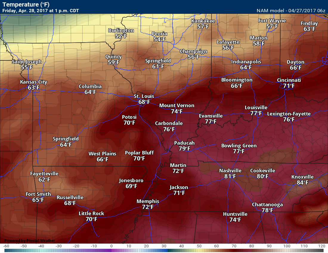
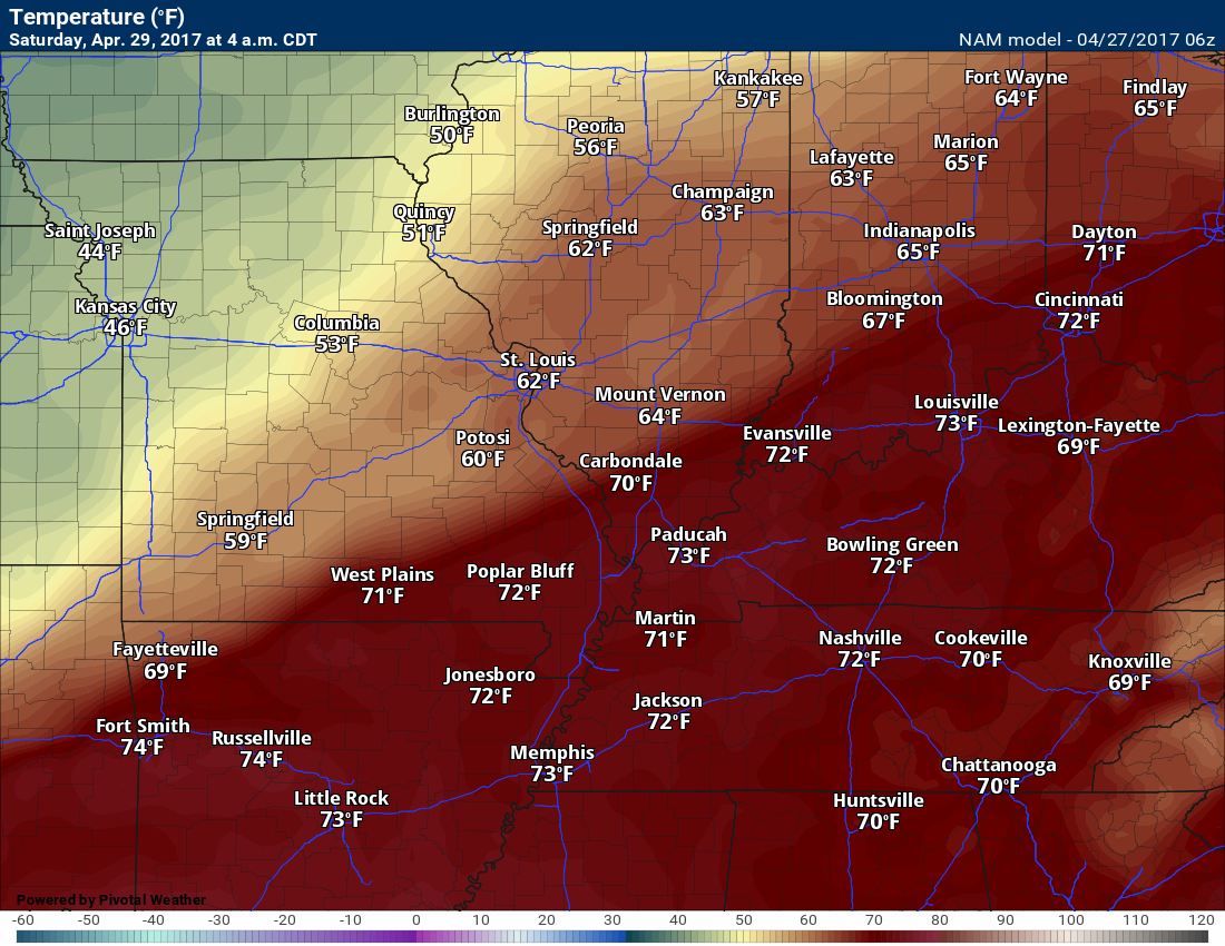
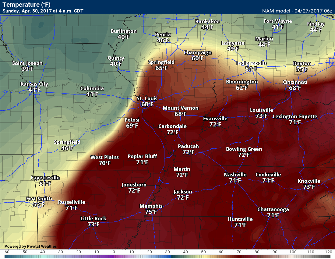
The NAM model shows this nicely
Friday afternoon temperatures
4 AM Saturday morning temperatures
Wow
4 AM Sunday temperatures. Again, wow
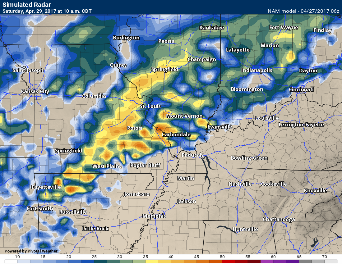
Let’s take a look at some future-cast radars
Real questions surround Saturday’s weather. It is possible that we don’t have much of a break. At least portions of the area. I am not overly confidence about Saturday’s forecast.
Saturday 10 am future-cast radar. Some rain and storms in the region.
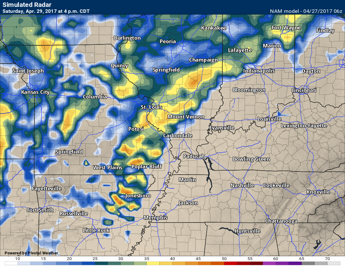
Saturday 4 pm future-cast radar
Plan on some showers and storms on Sunday/Sunday night, as well. Some of those storms could be heavy or severe.
WPC/NOAA rainfall forecast from now through Sunday night
Click images to enlarge
and

Find me on Twitter

We have regional radars and local city radars – if a radar does not update then try another one. Occasional browsers need their cache cleared. You may also try restarting your browser. That usually fixes the problem. Occasionally we do have a radar go down. That is why I have duplicates. Thus, if one fails then try another one.
During the winter you can track snow and ice by clicking the winterize button on the local city view interactive radars.
If you have any problems then please send me an email beaudodson@usawx.com
Interactive Weather Radar Page. Choose the city nearest your location: Click this link—
National interactive radar: Click this link.
Local interactive city radars include St Louis, Mt Vernon, Evansville, Poplar Bluff, Cape Girardeau, Marion, Paducah, Hopkinsville, Memphis, Nashville, Dyersburg, and all of eastern Kentucky. These are interactive radars. Local city radars – click here
Regional Radar

The official 6-10 day and 8-14 day temperature and precipitation outlook. Check the date stamp at the top of each image (so you understand the time frame).
The forecast maps below are issued by the Weather Prediction Center (NOAA)


The latest 8-14 day temperature and precipitation outlook. Note the dates are at the top of the image. These maps DO NOT tell you how high or low temperatures or precipitation will be. They simply give you the probability as to whether temperatures or precipitation will be above or below normal.


The Beau Dodson Weather APP is ready for Apple and Android users. The purpose of this app is for me to deliver your text messages instantly. ATT and Verizon have not always been reliable when it comes to speed. The app allows instant delivery.
Some of you have asked if you can keep receiving the texts on your phone and the app. The answer to that is, yes. The Android app will automatically allow that to happen. On the Apple app, however, you will need to go into your app and click settings. Make sure the green tab is OFF. Off means you will still receive the texts to your phone and the app. If you have any questions, then email me at beaudodson@usawx.com
The app is for text subscribers.
The direct download, for the Apple app, can be viewed here
https://itunes.apple.com/us/app/id1190136514
If you have not signed up for the texting service then you may do so at www.beaudodsonweather.com

The Android app is also ready.
Remember, the app’s are for www.weathertalk.com subscribers. The app allows your to receive the text messages faster than ATT and Verizon.
Here is the download link for the Android version Click Here

——————————————————–
If you have not signed up for the texts messages, then please do. Link www.beaudodsonweather.com
Your support helps with the following:

and


Who do you trust for your weather information and who holds them accountable?
I have studied weather in our region since the late 1970’s. I have 39 years of experience in observing our regions weather patterns. My degree is in Broadcast Meteorology and a Bachelor’s of Science.
My resume includes:
Member of the American Meteorological Society.
NOAA Weather-Ready Nation Ambassador.
Meteorologist for McCracken County Emergency Management. I served from 2005 through 2015.
Meteorologist for McCracken County Rescue. 2015 through current
I own and operate the Southern Illinois Weather Observatory.
I am the chief meteorologist for Weather Talk LLC. I am the owner of Weather Talk LLC.
I am also a business owner in western Kentucky.
Recipient of the Mark Trail Award, WPSD Six Who Make A Difference Award, Kentucky Colonel, and the Caesar J. Fiamma” Award from the American Red Cross.
In 2005 I helped open the largest American Cross shelter in U.S. history in Houston, Texas. I was deployed to help after Hurricane Katrina and Hurricane Rita. I was a shelter manager of one of the Houston, Texas shelter divisions.
In 2009 I was presented with the Kentucky Office of Highway Safety Award.
Recognized by the Kentucky House of Representatives for my service to the State of Kentucky leading up to several winter storms and severe weather outbreaks.
If you click on the image below you can read the Kentucky House of Representatives Resolution.

I am also President of the Shadow Angel Foundation which serves portions of western Kentucky and southern Illinois.
There is a lot of noise on the internet. A lot of weather maps are posted without explanation. Over time you should learn who to trust for your weather information.
My forecast philosophy is simple and straight forward.
- Communicate in simple terms
- To be as accurate as possible within a reasonable time frame before an event
- Interact with you on Twitter, Facebook, email, texts, and this blog
- Minimize the “hype” that you might see on some television stations or through other weather sources
- Push you towards utilizing wall-to-wall LOCAL TV coverage during severe weather events
Many of the graphics on this page are from www.weatherbell.com
WeatherBell is a great resource for weather model guidance.


You can sign up for my AWARE email by clicking here I typically send out AWARE emails before severe weather, winter storms, or other active weather situations. I do not email watches or warnings. The emails are a basic “heads up” concerning incoming weather conditions